In order to better manage coastline hazards, it is necessary to first understand the various processes that cause them. The waves, water levels and
|
|
|
- Adele Lawrence
- 5 years ago
- Views:
Transcription


1
2
3
4 In 2015 Council worked with coastal engineering consultants to complete a detailed analysis of coastal processes and the risks from coastal hazards along the coastal zone of the Shire. This study looked at a range of previously recorded information about coastal processes and hazards, and combined this information with new modelling to provide an up-to-date understanding of coastal hazard risk along our coastline and around our estuaries. In 2017 Council are now developing a new Coastal Management Program that will provide a pathway for addressing the identified coastal hazards, termed the Coastal Management Program Coastal Hazards (CMP-CH). The new CMP-CH sets out to: As the first step in developing the CMP-CH, this document provides an introduction and overview of the coastal processes and hazards that are relevant to the coastal zone of the Bega Valley Shire, and summarises the risks from these hazards. This report is largely based on the Bega Valley Shire Coastal Processes and Hazards Definition Study that was undertaken in 2015 (CPHDS; BMT WBM, 2015).
5 In order to better manage coastline hazards, it is necessary to first understand the various processes that cause them. The waves, water levels and winds, together with coastal currents and estuaries flowing into coastal waters, reshape beaches and shift beach sediments offshore, onshore and alongshore. At best, a dynamic balance is achieved with sandy beaches continuously adjusting in response to these forces. It is essential to appreciate that these processes do not operate in isolation, but interact with each other, often in quite complex ways and over very different time scales. Coastal hazards arise through both short term (storm) processes that are immediately obvious, as well as longer term background processes that are only noticeable to the most avid observers. This section provides a broad overview of the coastal processes that impact the coastline and estuaries of the Bega Valley Shire, with a focus on those processes that result in hazards. As well as the underlying geomorphology of the coastal zone, coastal processes relevant to the coastline of the Bega Valley Shire region include:
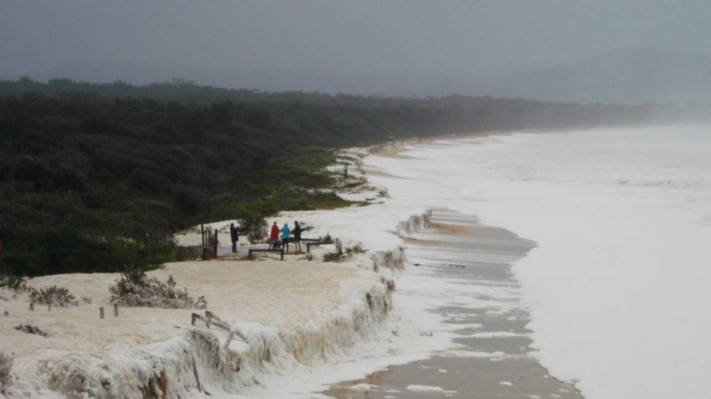
.")
6 The south coast region primarily experiences offshore waves from the south-east to southsouth-east, with approximately 50% of recorded waves originating from these directions. The modal offshore significant wave height is 1 2 m from the south-south-east, with these wave conditions occurring almost 20% of the time (BMT WBM, 2015). As waves move nearshore, they are modified by the processes of refraction, diffraction, wave-wave interaction and dissipation by bed friction and wave breaking. This typically results in smaller waves in the nearshore coastal zones, particularly in areas sheltered from the predominant wave direction such as Horseshoe Bay (Bermagui) and Pambula Beach. The coastal zone is also subject to periodic coastal storm events which are accompanied by larger wave conditions. These storm wave events are typically a major driver of rapid onset coastal hazards such as beach erosion and inundation. After the completion of the CPHDS in 2015, the far south coast region was impacted by the most significant coastal storm recorded in almost 40 years, with the east coast low of June As well as causing significant damage to infrastructure and beaches of the Bega Valley Shire coastline, this event resulted in a significant adjustment to the frequency distribution for extreme wave conditions. The updated extreme wave conditions since this event are reported in this summary, and therefore differ from the information presented in the CPHDS which was based on the best information available at the time. If the CPHDS was repeated using the revised extreme wave conditions (without analysis of updated storm demand measurements), the 2050 and 2100 erosion and recession hazard extents and all storm tide inundation extents may shift slightly landward. Small increases in the ocean boundary conditions for flood studies and nearshore design wave heights would also be expected due to additional wave setup that would occur.
7 During the 2016 storm, the Eden buoy broke a number of NSW wave records including the largest wave ever recorded in NSW of 17.7 m height, and the largest significant wave height of 8.5 m. On the basis of the updated uni-directional extreme wave height probability distribution, this event was of the order of 30 year Average Recurrence Interval (ARI). Of particular importance, however, is that during the peak of the storm the wave direction was from the east-north-east, making the event much more extreme, though there is not a long enough directional wave record on the Eden buoy to allow a rigorous directional wave probability analysis. A summary of the updated offshore extreme wave height frequency distribution undertaken for the Eden wave buoy (MHL, 2017) is presented in Figure 2.2. Astronomical tides, which are forced by the sun, moon and planets in NSW are semi-diurnal and vary significantly depending the lunar month and season. Open coast total tidal ranges along the south coast region are approximately m (BMT WBM, 2015). However, water levels can be elevated above the predictable tide levels (termed a tidal anomaly) during storm events through a number of contributing processes. Tidal anomalies primarily result from factors such as wind setup (or setdown) and barometric effects, which are often combined as storm surge. Water levels within the surf zone are also subject to wave setup and wave runup. This is shown diagrammatically in Figure 2.3. While the still water levels (tide, barometric set and wind setup) are generally considered reasonably constant within a relatively large region, wave setup and wave runup are

8 intrinsically dependent on the nearshore wave conditions and bathymetry, and therefore vary from site to site and with different environmental drivers (wave height, period, direction, etc). Elevated coastal water levels can also have significant backwater effects on coastal estuaries and rivers behind coastal dunes. This is particularly significant when coastal storms coincide with large rainfall events, and can exacerbate flooding in the coastal region. An example of this process was Back Lake in Merimbula during the June 2016 storm, when the entrance was artificially opened by Council at a water level of ~1.4 m AHD, however, wave setup and storm surge kept the entrance hydraulically closed and water levels in the lake peaked at almost 2 m AHD. Wind is the primary mechanism of sand movement from the sub-aerial beach zone to the dunes and fore dunes (BMT WBM, 2015), and can also be a driver of coastal erosion through the suspension or movement of sand off the un-vegetated beach zone. Winds vary seasonally with the Bega Valley region, as is observed in many places on the NSW coastline. Vegetated dunes help to trap sand within the beach system that might otherwise be lost. Historically, good coastal management has resulted in most beaches in the Bega Valley Shire have well vegetated dunes, sufficient to trap windborne sediment within the active beach system. While there is an ever present risk of dune blowout, often initiated by the development of informal walking or vehicle tracks, this is unlikely with the current and proposed future regimes of formalised beach accesses and dune vegetation management. Longshore sediment transport refers to the waterborne movement of sand along beaches from one end to the other, and in many areas of NSW, the movement of sand along the coastline from one beach to the next. Longshore sediment transport is primarily determined by the direction of the prevailing wave conditions, and can cause sediment movement either north or south along the coastline. As waves approach the coast at an oblique angle and break in the surf zone, a current is generated that mobilises sand. Due to the dominance of waves
 determined that sediment transport on beaches within the Bega Valley Shire region is strongly controlled by bounding headlands, which prohibits significant sediment bypassing from many")
9 originating from the south-east, net longshore sediment transport is primarily to the north in NSW. BMT WBM (2015) determined that sediment transport on beaches within the Bega Valley Shire region is strongly controlled by bounding headlands, which prohibits significant sediment bypassing from many beaches (Figure 2.4). Many of the embayed beaches are relatively closed sediment compartments, and longshore sediment transport tends to cause a rotation of the beach over time, as opposed to a net transfer of sediment along the coast. When El Niño climate conditions prevail (positive Southern Oscillation Index), this typically means that the southern ends of beaches erode in NSW, while the northern ends accrete. BMT WBM (2015) examined beaches within Bega Valley Shire and determined that beaches in the region have generally experienced this kind of beach rotation since the 1970s from when reasonable data sets exist and El Niño conditions have been predominant. Cross Shore sediment transport refers to the movement of sand on and off shore of beaches. Waves are again the primary mechanism of cross shore sediment movement. During storm events, when water levels are elevated and waves are larger, sand is removed from the dune and upper beach zones and deposited offshore in sand bars. While this process can result in a significant and rapid erosion of beaches, it is a part of a natural beach response to help dissipate more energetic storm wave conditions by flattening of the overall beach profile. In mild conditions, the waves generally promote the onshore movement of sediment to the subaerial beach at a gradual rate. Aeolian transport then begins to rebuild the dune system behind the beach. In general, cross-shore sediment transport initiated by waves does not result in a net loss of sediment from the active coastal zone, but rather temporary redistribution. Cross shore sediment transport is therefore very transient in nature, and this is the case for the beaches of the Bega Valley Shire.
 are common features of the coastline and Bega Valley Shire has more ICOLLs than other local government area in NSW.")
10 Natural coastal entrances can be highly variable in both location and condition. In NSW, Intermittently Closed and Open Lakes and Lagoons (ICOLLs) are common features of the coastline and Bega Valley Shire has more ICOLLs than other local government area in NSW. The entrances of ICOLLs tend to close during periods of low rainfall, and then break open (or are mechanically opened) during freshwater flood events. The location and state of these entrances can impact upon the coastal zone in which they occur. Estuary entrance processes influence numerous coastal hazards, primarily through: The somewhat unpredictable location at which ICOLLS will break open to the sea, and the tendency for entrances to wander laterally in position along a beach; Breaches of lower estuary walls through wave overtopping on adjacent beaches; Increased erosion of beaches in areas adjacent to the entrance (Figure 2.5). Climate change is likely to exacerbate coastal hazards in many regions, due to the adjustment, and in some cases amplification, of coastal processes. BMT WBM (2015) stated the following three (3) climate change influencing factors to be significant to coastal processes and hazards on the NSW coastal line: Sea level rise (SLR); Changes to the wave climate; and Changes to storm surge.
11 It is commonly understood that increases in sea level will result in a recession of the coastline. The magnitude of the recession varies, but typical values along exposed beaches the NSW coast are predicted to be m for every 1 m rise in the mean sea level. Three sea level rise trajectories were considered in the CPHDS and are summarised in Table 2.1 (relative to the 2014 mean sea level). The almost certain projection was based on extrapolation of the existing sea level rise rate (3.1 mm/year). The unlikely projection is consistent with sea level rise values of 0.4 m by 2050 and 0.9 m by 2100 (relative to the 1990 mean sea level) adopted for planning purposes by BVSC. The rare projection was based on sea level rise 1.5 times that considered for the unlikely trajectory in the CPHDS. Wave climate changes, including changes to wave direction and size, under climate change scenarios are generally less well understood. BMT WBM (2015) did not incorporate any changes in wave climate into the future predictions, recognising that current information suggests that future changes are likely within historical variability. Storm surge is a significant portion of elevated ocean levels experienced during coastal storm events. Changes to storm surge could potentially alter the extent of erosion experienced along the Shire s beaches during extreme events. However, BMT WBM (2015) concluded that the estimated change in storm surge for the south coast region is sufficiently uncertain (i.e. it is not known whether storm surge levels will increase or decrease) and small that no provisions need to be included in estimates of coastal hazards within the Bega Valley Shire region at present.
12 Coastal hazards are the result of one or more coastal processes impacting on beach and foreshore areas in the coastal zone, including the foreshore of our estuaries. In the NSW Coastal Management Act (2016), seven coastal hazards have been identified as potentially impacting the NSW coastline, as follows: 1. Beach erosion; 2. Shoreline recession (both underlying and recession driven by sea level rise) 3. Coastal lake or watercourse entrance instability; 4. Coastal inundation (both on open coast locations and within the lower estuaries); 5. Tidal Inundation; 6. Coastal cliff or slope instability; and 7. Erosion and inundation of foreshores caused by tidal waters and the action of waves, including the interaction of those waters with catchment floodwaters. The first four coastal hazards identified in the legislation, and an additional fifth hazard of sand drift, were examined in the CPHDS (the three remaining legislated coastal hazards were not directly considered as the study was completed prior to the introduction of the Act). Sand drift was included in the CPHDS as it is a hazard that has previously been encountered at locations along the NSW coast. This section provides a broad overview of the five coastal hazards that were considered in the CPHDS to have the potential to impact both natural and built assets as well as the safety of people in the Bega Valley Shire region. These hazards were identified and mapped in the CPHDS, and the potential impacts of the hazards have also been mapped as a part of the Coastal Management Program Coastal Hazards (see Appendix A). The definition of coastal hazards inherently involves uncertainty relating not only to coastal processes, but also to the uncertainties involved with climate change. There are uncertainties surrounding climate change projections, the timeframes over which this change may occur, as well as how climate change may affect the environment (BMT WBM, 2015). As prescribed in NSW government coastal management guidance, a risk-based approach was adopted for defining hazards across the study area in the CPHDS, allowing consideration of a range of extreme coastal events and their likelihood. The CPHDS considered three levels of uncertainty/likelihood when defining coastal hazard areas and extents, as summarised in Table 3.1. Hazards were also considered across three timeframes of 2014, 2050 and 2100 for each likelihood level.
13 In considering the coastal hazard risks documented in the CPHDS for planning purposes, BMT WBM (2015) make the following suggestions with regards to the qualitative uncertainty levels: The almost certain descriptor is used to identify areas that have a high likelihood of being exposed to coastal hazards; The unlikely descriptor provides the best estimate for coastal hazards that should be expected to occur, albeit infrequently. This level of likelihood is suggested to be used for hazard management and planning, and has been adopted by BVSC; and The rare descriptor provides a worst case scenario of coastal hazards (similar to the probable maximum flood estimate provided for flood hazard mapping), which would not be expected to occur, but may occur in an extreme case. During storm events, the combined actions of elevated water levels and large waves can cause significant erosion of beaches and their dunes. The amount of erosion that occurs is dependent on the environmental conditions and the antecedent conditions of the beach prior to the storm event (was the beach in an eroded or accreted state and was the dune vegetated?). While the sand is generally not removed from the active coastal zone and beaches tend to recover in the period after storm events, storm erosion can cause significant short term changes to the beach state. Beaches can recede over 50 m during a storm event. Short term beach erosion of this magnitude was experienced in the June 2016 storm, with examples of the change experienced at Tathra (with additional entrance instability influence) and Pambula Beaches shown in Figure 3.1.


14 The CPHDS considered three different values of beach erosion (storm demand), each related to a certain probability of occurrence. Two categories were used one for embayed beaches which generally have a smaller nearshore wave climate, and one for open coast beaches. Storm demand estimates were based on the analysis of historical photogrammetry data from 1944 to 2011, which generally showed that the largest erosion events recorded in that data occurred in the 1970s. Table 3.2 summarises the adopted storm demand volumes. 1 With the exception of Jiguma Beach, Merimbula Beach and Horseshoe Bay, which were assumed to be 80 to 100 m 3 /m for the almost certain and unlikely events, respectively (rare volume unknown). 2 With the exception of the southern end of Tathra Beach, which was assumed to increase linearly from 100 to 200 m 3 /m for the almost certain case and 125 to 250 m 3 /m for the unlikely case from the most southern end to just south of the Tathra Beach Family Park (rare volume unknown).
15 Unlike beach erosion, shoreline or beach recession is the long term migration of the shoreline landward over time. There are two main categories of shoreline recession that are typically considered in coastal management assessments, though by observation of a beach only, the two hazards are inseparable: 1. Underlying recession caused by the long term loss of sediment from the beach compartment over time; 2. Sea level rise recession which causes a shift in the equilibrium position of the beach profile, gradually moving it landward and upward as mean sea level increases. BMT WBM (2015) undertook an analysis of the available photogrammetric data at each beach in the Shire to determine long term underlying recession rates. While the data for Merimbula/Pambula and Tathra Beaches suggested underlying recession rates of the order of 0.1 m per year (of which the majority of recession is likely the result of sea level rise during the photogrammetry period), there was no clear trend across the region and ongoing monitoring of beaches was recommended. With regards to regional underlying recession rates, the CPHDS adopted: A nominal best estimate of 0.1 m/year; and A lower limit of 0 and an upper limit of 0.2 m/year to account for uncertainty. At Moorhead Beach, Horseshoe Bay, Cuttagee Beach and Aslings Beach, the photogrammetry data showed no evidence of long term recession, therefore no underlying recession was adopted for the Almost Certain and Unlikely probability conditions, and 0.1 m/year was conservatively adopted for the rare likelihood condition. It is a commonly applied theory that an elevation in sea level will result in a recession of beaches. BMT WBM (2015) used a variety of models to assess the recession due to sea level rise at each beach in the Bega Valley Shire. While recession due to sea level rise changes between beaches due to the site specific geomorphology, BMT WBM (2015) estimated the recession until 2100 (0.84 m of SLR) in the Unlikely scenario to be between m throughout the Bega Valley Shire region. BMT WBM (2015) undertook comprehensive mapping of erosion hazards throughout Bega Valley Shire for three planning periods: Immediate (2014); 2050; 2100.
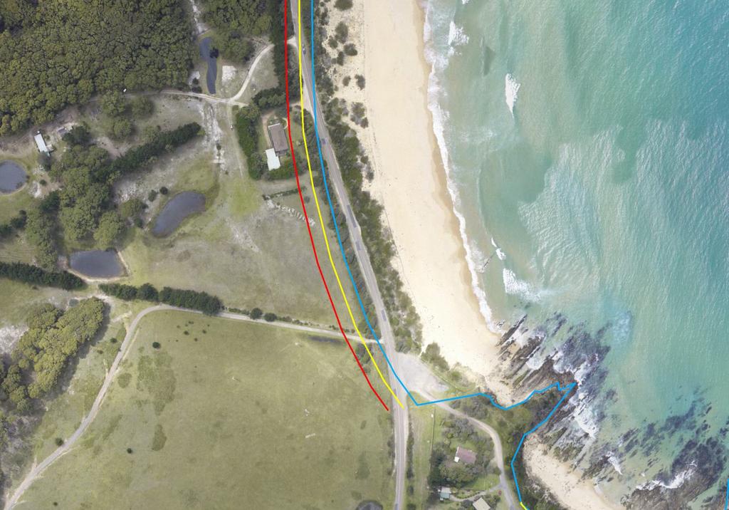
.")
16 The erosion hazard lines mapped in the CPHDS correspond to the landward side of the Zone of Slope Adjustment (ZSA) as described by Nielsen et al. (1992; Figure 3.2Error! Reference source not found.). This zone encompasses the limit of short-term beach erosion (storm demand) including slumping following a storm event. Very few new structures (except beach access ways, relocatable lifeguard towers, etc.) should be constructed within this zone (seaward of the erosion hazard lines). New structures may be constructed immediately landward of the erosion hazard lines if they are constructed on appropriately engineered piled foundations. While not mapped in the CPHDS, new structures built on only conventional foundations (e.g. slab-on-ground) should be located further landward of the erosion hazard lines due to the low strength of unconsolidated sand. This potentially unstable region behind the theoretical erosion escarpment is described as the Zone of Reduced Foundation Capacity (ZRFC). The width of the ZRFC is variable and is directly related to the height of the dune backing each beach. For example, for a 5 metre high dune, the erosion hazard lines should be offset landwards by 11 metres to avoid the ZRFC. Ultimately, forecasting beach erosion into the future is a combination of accounting for long term recession (both underlying and sea level rise), along with foreseeable short term storm erosion fluctuations which may occur with differing likelihood. Table 3.2 provides a summary of the assumed environmental conditions for the hazard lines mapped in the CPHDS. Error! Reference source not found. Figure 3.2 diagrammatically represents how both beach erosion and recession are incorporated into erosion hazard mapping and Figure 3.3 shows an example of erosion hazard lines at Cuttagee.
17
18
19 At many untrained coastal estuaries and rivers, there is inherent variability of the coastal entrance position. While some estuary channels and entrances are relatively stable through time and are held by natural geomorphic features (Merimbula Lake), others have historically broken through beach bars at various positions (Bega River at Mogareeka and Towamba River at Kiah). BMT WBM (2015) used aerial photography to assess the instability of each of the coastal entrances on a site by site basis to assess how they may change over time into the future. A summary is provided below: Wallaga Lake predominately open, although it does close during sustained dry periods. No significant migration of the entrance is expected into the future, as the entrance lays immediately adjacent to Morunna Point. Bermagui River is a permanently open, trained entrance. However, if a significant erosion event occurs, there is the potential of a dune breakthrough on Moorhead Beach, opening an alternate entrance to the river. Baragoot Lake, Cuttagee Lake and Bunga Lagoon predominantly closed (Haines, 2006), untrained entrances that scour under large flood events. Due to the undeveloped nature of the areas, changes to the entrance stability were not considered a hazard. Murrah Lake predominantly open, although still scours significantly under large flood events. Due to the undeveloped nature of the area, changes to the entrance stability were not considered a hazard. Wapengo Lagoon is a predominately open (Haines, 2006), untrained entrance. No significant migration of the entrance is expected into the future due to geomorphic constraints. Bega River predominately open, although it does close during sustained dry periods. When in a closed state, it is generally mechanically opened by Council to alleviate flooding in the lower estuary. However, natural openings have also occurred. CMG (2000) suggested that historically, the entrance was located 1.5 km to the south of the existing entrance and that mechanical opening of the existing entrance (when in a closed state) is required to prevent future dune breaching at this alternative location. Wallagoot Lake - is a predominately closed (Haines, 2006), untrained entrance. No significant migration of the entrance is expected into the future, as the entrance lays immediately adjacent to Turingal Head. The entrance to the lake is within Bournda National Park, and as such there is little development at risk of coastal hazards if the entrance did migrate (though sites of Aboriginal cultural significance may be impacted). The lake entrance is artificially opened by Council to reduce flooding of Wallagoot Lake Road on the northern foreshore of the lake. Pambula River - naturally permanent opening. No significant migration of the entrance is expected into the future due to geomorphic constraints. Merimbula Lake naturally permanent opening. BMT WBM (2015) indicated that an increase in sea levels may decrease the effectiveness of the geomorphic controls, potentially increasing the likelihood of closure.

20 Back Lake is predominately closed and is regularly manually opened to prevent flooding in the lower estuary, although it has historically opened naturally. No significant migration of the entrance is expected into the future. Lake Curalo almost equally open and closed, untrained entrance. When in a closed state, it is mechanically opened by Council to alleviate flooding around the lake foreshore. No significant migration of the entrance is expected into the future. Towamba River naturally permanent opening at the southern end of a thin section of sandy dune at Whale Beach, shown in Figure 3.4. Historically, the beach has also been breached in several additional locations during catchment flood events. Wonboyn Lake - predominately open, although it does close during sustained dry periods. No significant migration of the entrance is expected into the future. Coastal inundation is the flooding of coastal areas by ocean waters and is typically caused by elevated ocean water levels combined with extreme waves impacting the coast. As described in Section 2.4, elevated water levels consist of (predictable) tides, which are forced by the sun, moon and planets (astronomical tides), and a tidal anomaly. Tidal anomalies primarily result from factors such as wind setup (or setdown) and barometric effects, which are often combined as storm surge. Water levels within the surf zone are also subject to wave setup and wave runup. Consequently, inundation levels along the coast are characterised by two components:
21 A quasi-static component, which includes the effects of elevated water levels due to tide, storm surge, flooding, wind setup and wave setup; and A dynamic component, which includes the effects of wave runup and wave overtopping caused by the direct impact of waves on the beach and coastal structures. BMT WBM (2015) considered coastal inundation of ocean beaches and cliffs separately to the coastal inundation of low lying areas around estuary foreshores. Due to the height of the dunes, BMT WBM (2015) determined that direct inundation of areas behind ocean beaches and cliffs due to quasi-static water levels is unlikely for most areas of the Shire. Therefore, these areas are susceptible to coastal inundation only through wave runup and overtopping. Wave runup levels reported by BMT WBM (2015) were based on a combination of the 100 year ARI wave condition (for the deep water wave direction resulting in the maximum wave height at each sub section) with the 100 year ARI water level and are summarised in Table 3.4. Wave runup levels in the CPHDS were calculated using the methods described by Nielsen and Hanslow (1991; sandy beaches) and EurOtop (2007; seawalls and cliffs). Note that predictions of wave runup levels were only provided for present day conditions.
22 Unpublished wave runup levels measured around the Shire after the June 2016 storm (Blacka, M. 2016, pers. comm.) are shown in Table 3.5. The levels predicted in the CPHDS were in good agreement with these levels observed during June Wave overtopping only occurs in cases where the design wave runup level exceeds the dune, seawall or cliff crest. BMT WBM (2015) identified areas where wave overtopping may occur (excluding areas adjacent to creek and lagoon entrances) to be:
23 Barragga Bay and Armonds Bay (although little risk to development); Tathra Beach, Moon Bay, Nelsons Beach, Tathra Headland, Tathra Wharf and Wharf Road; Pambula Beach; Cattle Bay, Cocora, Beach, Bungo Beach, Quarantine Bay, Brandy Creek Beach, the southern parts of Boydtown Beach, Whale Beach and Fisheries Beach; and Disaster Bay. The low-lying area behind snug cove as well as Aslings beach are also known to be susceptible to wave overtopping, though were not identified in the CPHDS. The quasi-static inundation level is the most representative oceanic inundation level for areas located away from direct impact of the waves, including the foreshores of lower estuary areas. Inundation levels in the lower estuary may also be affected by coincident catchment flooding, however this was not considered in the CPHDS. It should be noted that formal flood studies have been undertaken for several of the major estuaries in the Shire, and these studies have considered the joint impacts of catchment flooding and elevated ocean water levels. A summary of the climatic conditions assumed by BMT WBM (2015) for inundation hazard mapping for each planning period is provided in Table 3.6. A complete summary of the final coastal inundation levels derived by BMT WBM (2015) is also provided in Table 3.7.
24
25 Sand drift is the transportation of sand by wind action. Wind is the primary mechanism of sand movement from the sub-aerial beach zone to the dunes and fore dunes, allowing the dunes to rebuild after storm events. However, if the dunes are unvegetated, the sand drift can cause a net loss of sediment from the beach system and cause a problem for coastal developments.
26 BMT WBM (2015) Bega Valley Shire Coastal Processes and Hazards Definition Study, Prepared for Bega Valley Shire Council. Coastal & Marine Geosciences [CMG] (2000) Bega River Estuary Sediment Study, Prepared for the Bega Valley Shire Council, January DECCW (2010) NSW Estuaries and Coastal Catchments Spatial Database. EurOtop (2007), Wave Overtopping of Sea Defences and Related Structures: Assessment Manual. Haines, P E (2006) Physical and Chemical Behaviour and Management of Intermittently Closed and Open Lakes and Lagoons (ICOLLs) in NSW. Ph.D. Thesis. Griffith University, Gold Coast. Kidd, R W (1978), Estuarine Sediment Regimes, Far South Coast, New South Wales, Ph.D. thesis, Macquarie University, Sydney. Manly Hydraulics Laboratory [MHL] (2017) NSW Wave Climate Extreme Value Analysis, Report MHL2538, In Prep. Nielsen, A F, Lord, D B and Poulos, H G (1992) Dune Stability Considerations for Building Foundations, Vol. CE34 No. 2 June Nielsen, P and Hanslow, D J (1991), Wave Runup Distributions on Natural Beaches, Journal of Coastal Research, pp OEH (2016), NSW Coastal Management Act 2016, Act No. 20 of 2016, Assented on 7 June NSW Government (1990), Coastline Management Manual, NSW Government Printer
Appendix M: Durras Lake Tailwater Conditions
 Appendix M: Durras Lake Tailwater Conditions M.1 Preamble WRL has completed a tailwater condition assessment for the entrance to Durras Lake, to be used as an ocean boundary condition for a future flood
Australian Coastal Councils Conference
 Australian Coastal Councils Conference Kiama March 2019 Where Has My Beach Gone? (and what can I do about it?) Dr Andrew McCowan Water Technology Where Has My Beach Gone? Where Has My Beach Gone? Where
4/06/2014. Need for Guidance. East Coast Lows. Catchment and coastal flood events can combine! Project 18 ARR Review
 Need for Guidance Development of Practical Guidance for Coincidence of Catchment Flooding and Oceanic Inundation Angela Toniato, NSW OEH Duncan McLuckie, NSW OEH Grantley Smith, Water Research Laboratory
Impacts of breakwaters and training walls
 Across the eastern seaboard of Australia, breakwaters and training walls have instigated fundamental perturbations to coastal and estuary processes. This has induced long-term changes to foreshore alignments,
Coastal Inundation. An Overview for TCDC
 Coastal Inundation An Overview for TCDC Rick Liefting Team Leader Regional Hazards and Environmental Compliance Integrated Catchment Management Waikato Regional Council Photo: Sugar Loaf Wharf, Coromandel.
To: William Woods, Jenni Austin Job No: CentrePort Harbour Deepening Project - Comments on community queries
 Memo To: William Woods, Jenni Austin From: Richard Reinen-Hamill Date: Subject: cc: 1 Purpose This memo sets out our response to issues raised at and after Seatoun community consultation sessions held
CROSS-SHORE SEDIMENT PROCESSES
 The University of the West Indies Organization of American States PROFESSIONAL DEVELOPMENT PROGRAMME: COASTAL INFRASTRUCTURE DESIGN, CONSTRUCTION AND MAINTENANCE A COURSE IN COASTAL DEFENSE SYSTEMS I CHAPTER
SELECTION OF THE PREFERRED MANAGEMENT OPTION FOR STOCKTON BEACH APPLICATION OF 2D COASTAL PROCESSES MODELLING
 SELECTION OF THE PREFERRED MANAGEMENT OPTION FOR STOCKTON BEACH APPLICATION OF 2D COASTAL PROCESSES MODELLING C Allery 1 1 DHI Water and Environment, Sydney, NSW Abstract This paper presents an approach
Shorelines Earth - Chapter 20 Stan Hatfield Southwestern Illinois College
 Shorelines Earth - Chapter 20 Stan Hatfield Southwestern Illinois College The Shoreline A Dynamic Interface The shoreline is a dynamic interface (common boundary) among air, land, and the ocean. The shoreline
CHAPTER 8 ASSESSMENT OF COASTAL VULNERABILITY INDEX
 124 CHAPTER 8 ASSESSMENT OF COASTAL VULNERABILITY INDEX 8.1 INTRODUCTION In order to assess the vulnerability of the shoreline considered under this study against the changing environmental conditions,
HURRICANE SANDY LIMITED REEVALUATION REPORT UNION BEACH, NEW JERSEY DRAFT ENGINEERING APPENDIX SUB APPENDIX D SBEACH MODELING
 HURRICANE SANDY LIMITED REEVALUATION REPORT UNION BEACH, NEW JERSEY DRAFT ENGINEERING APPENDIX SUB APPENDIX D SBEACH MODELING Rev. 18 Feb 2015 1 SBEACH Modeling 1.0 Introduction Following the methodology
Beach profile surveys and morphological change, Otago Harbour entrance to Karitane May 2014 to June 2015
 Beach profile surveys and morphological change, Otago Harbour entrance to Karitane May 2014 to June 2015 Prepared for Port Otago Ltd Martin Single September 2015 Shore Processes and Management Ltd Contact
COASTAL ENVIRONMENTS. 454 lecture 12
 COASTAL ENVIRONMENTS Repeated movement of sediment & water constructs a beach profile reflecting the balance between average daily or seasonal wave forces and resistance of landmass to wave action Coasts
Figure 4, Photo mosaic taken on February 14 about an hour before sunset near low tide.
 The Impact on Great South Bay of the Breach at Old Inlet Charles N. Flagg and Roger Flood School of Marine and Atmospheric Sciences, Stony Brook University Since the last report was issued on January 31
OECS Regional Engineering Workshop September 29 October 3, 2014
 B E A C H E S. M A R I N A S. D E S I G N. C O N S T R U C T I O N. OECS Regional Engineering Workshop September 29 October 3, 2014 Coastal Erosion and Sea Defense: Introduction to Coastal Dynamics David
Future Coasts Port Fairy Coastal Hazard Assessment
 Future Coasts Port Fairy Coastal Hazard Assessment WRL Technical Report 2012/21 April 2013 by F Flocard, J T Carley, D S Rayner, P F Rahman and I R Coghlan Water Research Laboratory University of New South
Volume and Shoreline Changes along Pinellas County Beaches during Tropical Storm Debby
 Volume and Shoreline Changes along Pinellas County Beaches during Tropical Storm Debby Ping Wang and Tiffany M. Roberts Coastal Research Laboratory University of South Florida July 24, 2012 Introduction
Oceans and Coasts. Chapter 18
 Oceans and Coasts Chapter 18 Exploring the oceans The ocean floor Sediments thicken and the age of the seafloor increases from ridge to shore The continental shelf off the northeast United States Constituent
Inlet Management Study for Pass-A-Grille and Bunces Pass, Pinellas County, Florida
 Inlet Management Study for Pass-A-Grille and Bunces Pass, Pinellas County, Florida Final Report Submitted By Ping Wang, Ph.D., Jun Cheng Ph.D., Zachary Westfall, and Mathieu Vallee Coastal Research Laboratory
Wave-dominated embayed beaches. Andrew D Short School of Geosciences University of Sydney
 Wave-dominated embayed beaches Andrew D Short School of Geosciences University of Sydney Wave-dominated embayed beaches wave-dominated beaches embayed beaches morphodynamics of W-D embayed beaches circulation,
Chapter 10 Lecture Outline. The Restless Oceans
 Chapter 10 Lecture Outline The Restless Oceans Focus Question 10.1 How does the Coriolis effect influence ocean currents? The Ocean s Surface Circulation Ocean currents Masses of water that flow from one
1. Introduction. 1.1 Background
 1. Introduction 1.1 Background The Eurobodalla Shire Council (ESC) coastline is approximately 110 km long extending from South Durras to Mystery Bay and includes Batemans Bay east of the Tollgate Bridge.
Draft Coastal Zone Management Plan for Byron Shire Coastline
 Byron Shire Council Draft Coastal Zone Management Plan for Byron Shire Coastline 26 November 2010 #1030842 Presentation Outline o o o o o o o Brief Byron Shire erosion history What is a CZMP? Why Develop
Q1. What are the primary causes/contributors to coastal erosion at Westshore and the concept of longshore / littoral drift.
 Q1. What are the primary causes/contributors to coastal erosion at Westshore and the concept of longshore / littoral drift. In order of (timing related) contribution to present problem 1. Beach is too
COUPLED MANAGEMENT STRATEGY LAKE CATHIE ESTUARY & COAST
 Lake Cathie Progress Association Inc. ABN 28 251 433 854 P.O. Box 247 Lake Cathie NSW 2445 PHONE/FAX: 02 6584 8211 EMAIL: r3packag@bigpond.com 20 th October 2009 Port Macquarie Hastings Council PO Box
ST LEONARDS COASTAL HAZARD VULNERABILITY ASSESSMENT
 Level 12, 333 Collins Street Melbourne VIC 3000 Australia Telephone: +61 3 8676 3500 Facsimile: +61 3 8676 3505 www.worleyparsons.com WorleyParsons Services Pty Ltd ABN 61 001 279 812 23 November 2011
Implications of changes to El Niño Southern Oscillation for coastal vulnerability in NSW
 Implications of changes to El Niño Southern Oscillation for coastal vulnerability in NSW By Thomas Mortlock (Thomas.mortlock@mq.edu.au) El Niño Southern Oscillation (ENSO) has a strong impact on weather
Chapter - Oceans and Coasts
 Chapter - Oceans and Coasts Discussion: What do oceans contribute to the environment of Earth? How do Earth s major systems relate to the oceans? Oceans and Coasts Oceans are important - Thermal regulation
Beach Profiles. Topics. Module 9b Beach Profiles and Crossshore Sediment Transport 3/23/2016. CE A676 Coastal Engineering
 Beach Profiles AND CROSS-SHORE TRANSPORT Orson P. Smith, PE, Ph.D., Professor Emeritus Topics Features of beach and nearshore profiles Equilibrium profiles Cross-shore transport References Text (Sorensen)
THE HYDRAULIC AND MORPHOLOGICAL RESPONSE OF A LARGE COASTAL LAKE TO RISING SEA LEVELS
 THE HYDRAULIC AND MORPHOLOGICAL RESPONSE OF A LARGE COASTAL LAKE TO RISING SEA LEVELS Mr Evan K Watterson 1 Dr Joanna M Burston 1 Ms Heather Stevens 2 Mr Dan J Messiter 1 1 Author affiliation: WorleyParsons
DUNE STABILIZATION AND BEACH EROSION
 DUNE STABILIZATION AND BEACH EROSION CAPE HATTERAS NATIONAL SEASHORE NORTH CAROLINA ROBERT DOLAN PAUL GODFREY U. S. DEPARTMENT OF INTERIOR NATIONAL PARK SERVICE OFFICE OF NATURAL SCIENCE WASHINGTON, D.
INTRODUCTION TO COASTAL ENGINEERING
 The University of the West Indies Organization of American States PROFESSIONAL DEVELOPMENT PROGRAMME: COASTAL INFRASTRUCTURE DESIGN, CONSTRUCTION AND MAINTENANCE A COURSE IN COASTAL DEFENSE SYSTEMS I CHAPTER
DUXBURY WAVE MODELING STUDY
 DUXBURY WAVE MODELING STUDY 2008 Status Report Duncan M. FitzGerald Peter S. Rosen Boston University Northeaster University Boston, MA 02215 Boston, MA 02115 Submitted to: DUXBURY BEACH RESERVATION November
Future Condi,ons coastal hazard modeling and mapping
 Future Condi,ons coastal hazard modeling and mapping Presented by Bob Ba:alio, PE Environmental Science Associates, Inc. (ESA) On behalf of the physical processes team (USGS, TerraCosta- Scripps, ESA)
page - Laboratory Exercise #5 Shoreline Processes
 page - Laboratory Exercise #5 Shoreline Processes Section A Shoreline Processes: Overview of Waves The ocean s surface is influenced by three types of motion (waves, tides and surface currents). Shorelines
HARBOUR SEDIMENTATION - COMPARISON WITH MODEL
 HARBOUR SEDIMENTATION - COMPARISON WITH MODEL ABSTRACT A mobile-bed model study of Pointe Sapin Harbour, in the Gulf of St. Lawrence, resulted in construction of a detached breakwater and sand trap to
City of Del Mar Local Coastal Plan (LCP) Amendment for Sea Level Rise and Coastal Flooding
 Amendment for Sea Level Rise and Coastal Flooding") City of Del Mar Local Coastal Plan (LCP) Amendment for Sea Level Rise and Coastal Flooding 6/22/17 Presentation to Sea Level Rise Stakeholder- Technical Advisory Committee (STAC) Nick Garrity, P.E. Lindsey
City of Del Mar Local Coastal Plan (LCP) Amendment for Sea Level Rise and Coastal Flooding 6/22/17 Presentation to Sea Level Rise Stakeholder- Technical Advisory Committee (STAC) Nick Garrity, P.E. Lindsey
Exemplar for Internal Assessment Resource Geography Level 3. Resource title: The Coastal Environment Kaikoura
 Exemplar for internal assessment resource Geography 3.5A for Achievement Standard 91430 Exemplar for Internal Assessment Resource Geography Level 3 Resource title: The Coastal Environment Kaikoura This
There are many different kinds of beaches which are generally characterized by the dominance of waves, tides, rivers and currents, and in particular
 Fig. 11-11, p. 253 There are many different kinds of beaches which are generally characterized by the dominance of waves, tides, rivers and currents, and in particular differ by the amount of energy, which
Long Beach Island Holgate Spit Little Egg Inlet Historical Evolution Introduction Longshore Transport Map, Survey and Photo Historic Sequence
 Appendix B Long Beach Island Holgate Spit Little Egg Inlet Historical Evolution Introduction The undeveloped southern end of Long Beach Island (LBI) is referred to as the Holgate spit as it adjoins the
Julebæk Strand. Effect full beach nourishment
 Julebæk Strand Effect full beach nourishment Aim of Study This study is a part of the COADAPT funding and the aim of the study is to analyze the effect of beach nourishment. In order to investigate the
Coastal Hazards Management Plan Marengo to Skenes Creek
 Coastal Hazards Management Plan Marengo to Skenes Creek October 2012 ISO 9001 QEC22878 SAI Global DOCUMENT STATUS Version Doc type Reviewed by Approved by Date issued v04 Final Report GLR TJW 26/10/2012
Photo by: Darryl Hatheway, 2011
 Photo by: Darryl Hatheway, 2011 September 11, 2015 Presentation Discussion Examine PFD V-Zone Mapping in Wave Runup Dominated West Coast Application of PFD V-Zone Mapping Criteria in Pacific G&S PFD V-Zone
Appendix E Cat Island Borrow Area Analysis
 Appendix E Cat Island Borrow Area Analysis ERDC/CHL Letter Report 1 Cat Island Borrow Area Analysis Multiple borrow area configurations were considered for Cat Island restoration. Borrow area CI1 is located
Earth Science Chapter 16 Section 3 Review
 Name: Class: Date: Earth Science Chapter 16 Section 3 Review Multiple Choice Identify the choice that best completes the statement or answers the question. 1. The movement of water that parallels the shore
INTRODUCTION TO COASTAL ENGINEERING AND MANAGEMENT
 Advanced Series on Ocean Engineering Volume 16 INTRODUCTION TO COASTAL ENGINEERING AND MANAGEMENT J. William Kamphuis Queen's University, Canada World Scientific Singapore New Jersey London Hong Kong Contents
Coastal Change and Conflict
 Coastal Change and Conflict Outline of the Topic Contrasting Coasts why do all coasts not look the same? Geology of the coast the impact rock structure has on the coastline Waves Constructive and destructive
PUBLIC EXHIBITION OF COASTAL ZONE MANAGEMENT PLAN FOR COLLAROY-NARRABEEN BEACH AND FISHERMANS BEACH
 ITEM 8.3 REPORTING MANAGER TRIM FILE REF 2014/110936 ATTACHMENTS PUBLIC EXHIBITION OF COASTAL ZONE MANAGEMENT PLAN FOR COLLAROY-NARRABEEN BEACH AND FISHERMANS BEACH GROUP MANAGER NATURAL ENVIRONMENT 1
Lecture Outlines PowerPoint. Chapter 15 Earth Science, 12e Tarbuck/Lutgens
 Lecture Outlines PowerPoint Chapter 15 Earth Science, 12e Tarbuck/Lutgens 2009 Pearson Prentice Hall This work is protected by United States copyright laws and is provided solely for the use of instructors
MODELLING THE SHORELINE IMPACTS OF RICHMOND RIVER TRAINING WALLS
 MODELLING THE SHORELINE IMPACTS OF RICHMOND RIVER TRAINING WALLS D Patterson 1 1 BMT WBM / University Of Qld, Brisbane, QLD Introduction The construction of river entrance training walls is generally aimed
LAB: WHERE S THE BEACH
 Name: LAB: WHERE S THE BEACH Introduction When you build a sandcastle on the beach, you don't expect it to last forever. You spread out your towel to sunbathe, but you know you can't stay in the same spot
USE OF SEGMENTED OFFSHORE BREAKWATERS FOR BEACH EROSION CONTROL
 .. CETN-III-22 4/84 PURPOSE: USE OF SEGMENTED OFFSHORE BREAKWATERS FOR BEACH EROSION CONTROL To provide information on the functional application of and general design considerations for using offshore
Sandy Beach Morphodynamics. Relationship between sediment size and beach slope
 Sandy Beach Morphodynamics Relationship between sediment size and beach slope 1 Longshore Sorting - Willard Bascom Beach Slope, Grain Size, and Wave Energy Beach at Sandwich Bay, Kent, UK near the Straights
Flooding Tailwater Levels for NSW Coastal Entrances
 Flooding Tailwater Levels for NSW Coastal Entrances E Watterson 1, B You 2, T Baldock 3, D Callaghan 3 and P Nielsen 3 1 SMEC Australia, Newcastle (email evan.watterson@smec.com) 2 Coastal and Marine Science,
COASTAL SYSTEMS WAVE ENERGY
 WAVE ENERGY The energy of a wave determines its ability to erode and transport material on the coast Wave energy depends on the fetch, the distance the wind has blown the wave Wind strength and wind duration
IMPACTS OF COASTAL PROTECTION STRATEGIES ON THE COASTS OF CRETE: NUMERICAL EXPERIMENTS
 IMPACTS OF COASTAL PROTECTION STRATEGIES ON THE COASTS OF CRETE: NUMERICAL EXPERIMENTS Tsanis, I.K., Saied, U.M., Valavanis V. Department of Environmental Engineering, Technical University of Crete, Chania,
4/20/17. #30 - Coastlines - General Principles Coastlines - Overview
 Writing Assignment Due one week from today by 11:59 pm See main class web pages for detailed instructions Essays will be submitted in Illinois Compass (instructions later) Pick one: Earthquakes, tsunamis,
ESTIMATION OF EXTREME WATER LEVELS AT NSW COASTAL ENTRANCES
 ESTIMATION OF EXTREME WATER LEVELS AT NSW COASTAL ENTRANCES Zai-Jin YOU Coastal Science, NSW Office of Environment and Heritage Level 4, 26 Honeysuckle Drive, Newcastle NSW 2300 Email: bob.you@environment.nsw.gov.au
Technical Article No. 2.3
 Technical Article No. 2.3 INTRODUCTION Estuary, stream and river entrances can experience significant natural shoreline changes, typically much larger than experienced on other areas of the same coast.
Bay County, MI Coastal Hazard Analysis Flood Risk Review Meeting. May 14, 2018
 Bay County, MI Coastal Hazard Analysis Flood Risk Review Meeting May 14, 2018 Agenda Introductions Coastal Flood Risk Study and Mapping Program Current Status Technical Overview of Study and Mapping Floodplain
Taranaki Tsunami Inundation Analysis. Prepared for Taranaki Civil Defence Emergency Management Group. Final Version
 Taranaki Tsunami Inundation Analysis Prepared for Taranaki Civil Defence Emergency Management Group Final Version June 2012 AM 12/07 HBRC Plan Number 4362 Asset Management Group Technical Report Prepared
2 How do I use the Coastal Inundation Tool?
 Coastal Inundation Tool Guidance 1 Overview The Coastal Inundation Tool provides users with a tool to quickly understand the susceptibility of coastal areas to coastal inundation due to tides, storms and
Undertow - Zonation of Flow in Broken Wave Bores
 Lecture 22 Nearshore Circulation Undertow - Zonation of Flow in Broken Wave Bores In the wave breaking process, the landward transfer of water, associated with bore and surface roller decay within the
Performance of Upham Beach T-Groin Project and Its Impact to the Downdrift Beach
 Performance of Upham Beach T-Groin Project and Its Impact to the Downdrift Beach Progress Report for the Period of October 2008 to April 2009 Submitted by Ping Wang, Ph.D., and Tiffany M. Roberts Department
ALTERNATIVES FOR COASTAL STORM DAMAGE MITIGATION
 ALTERNATIVES FOR COASTAL STORM DAMAGE MITIGATION Dave Basco Old Dominion University, Norfolk, Virginia, USA National Park Service Photo STRUCTURAL (changes to natural, physical system) hardening (seawalls,
FOR INFORMATION ONLY. Gold Coast Seaway Channel Scour and Rock Wall Stability Investigation. R.B doc December 2011
 A part of BMT in Energy and Environment Gold Coast Seaway Channel Scour and Rock Wall Stability Investigation R.B18625.001.00.doc December 2011 Gold Coast Seaway Channel Scour and Rock Wall Stability Investigation
The Impact on Great South Bay of the Breach at Old Inlet Charles N. Flagg School of Marine and Atmospheric Sciences, Stony Brook University
 The Impact on Great South Bay of the Breach at Old Inlet Charles N. Flagg School of Marine and Atmospheric Sciences, Stony Brook University The previous report provided a detailed look at the conditions
CMS Modeling of the North Coast of Puerto Rico
 CMS Modeling of the North Coast of Puerto Rico PRESENTED BY: Dr. Kelly Rankin Legault, Ph.D., P.E. 1 Dr. Alfredo Torruella, Ph.D. 2 1 USACE Jacksonville District 2 University of Puerto Rico October 2016
Inspection of Clarence City Beaches following Winter 2011 Storm Events
 18 July 2011 WRL Ref: WRL10086TDS L20110718 Messrs P Watson & I Preece Clarence City Council PO Box 96 Rosny Park TAS 7018 By email: pwatson@ccc.tas.gov.au ipreece@ccc.tas.gov.au Dear Phil/Ian, Inspection
NORTHERN CELL OPTIONS SHORTLIST RECOMMENDATIONS
 OPTIONS SHORTLIST RECOMMENDATIONS Coastal Unit C: Bayview Options recommended for MCDA scoring. Status quo. Planting 3. Renourishment (gravel) 6. Beach-scraping 7. Restore shingle crest. Inundation accommodation
Marginal Marine Environments
 Marginal Marine Environments Delta: discrete shoreline protuberances formed where rivers enter oceans, semi-enclosed seas, lakes or lagoons and supply sediment more rapidly than it can be redistributed
Undertow - Zonation of Flow in Broken Wave Bores
 Nearshore Circulation Undertow and Rip Cells Undertow - Zonation of Flow in Broken Wave Bores In the wave breaking process, the landward transfer of water, associated with bore and surface roller decay
Update: UNSW s Research Program for Extreme Waves on Fringing Reefs. Matt Blacka,Kristen Splinter, Ron Cox
 Update: UNSW s Research Program for Extreme Waves on Fringing Reefs Matt Blacka,Kristen Splinter, Ron Cox Overview Research Area 1: Extreme wave and water level processes for fringing reef coastlines Research
Advanced Series on Ocean Engineering - Volume 14 COASTAL STABILIZATION. Richard Silvester John R C Hsu. \v? World Scientific
 Advanced Series on Ocean Engineering - Volume 14 COASTAL STABILIZATION Richard Silvester John R C Hsu \v? World Scientific Contents PREFACE xv 1 INTRODUCTION 1 /. / Coastal Environment 2 J.2 State of Beach
Shoreline Response to an Offshore Wave Screen, Blairgowrie Safe Boat Harbour, Victoria, Australia
 Shoreline Response to an Offshore Wave Screen, Blairgowrie Safe Boat Harbour, Victoria, Australia T.R. Atkins and R. Mocke Maritime Group, Sinclair Knight Merz, P.O. Box H615, Perth 6001, Australia ABSTRACT
Reading Material. Inshore oceanography, Anikouchine and Sternberg The World Ocean, Prentice-Hall
 Reading Material Inshore oceanography, Anikouchine and Sternberg The World Ocean, Prentice-Hall BEACH PROCESSES AND COASTAL ENVIRONMENTS COASTAL FEATURES Cross section Map view Terminology for Coastal
Chapter 4 EM THE COASTAL ENGINEERING MANUAL (Part I) 1 August 2008 (Change 2) Table of Contents. Page. I-4-1. Background...
 1 August 2008 (Change 2) Table of Contents. Page. I-4-1. Background...") Chapter 4 EM 1110-2-1100 THE COASTAL ENGINEERING MANUAL (Part I) 1 August 2008 (Change 2) Table of Contents I-4-1. Background... Page I-4-1 a. Shore Protection Planning and Design, TR 4... I-4-1 b. Shore
Chapter 4 EM 1110-2-1100 THE COASTAL ENGINEERING MANUAL (Part I) 1 August 2008 (Change 2) Table of Contents I-4-1. Background... Page I-4-1 a. Shore Protection Planning and Design, TR 4... I-4-1 b. Shore
EXISTING AND PLANNED STRATEGIES AND ACTIONS CONNECTED WITH COASTAL PROTECTION IN ASPECT OF PREDICTED SEA LEVEL RISE
 EXISTING AND PLANNED STRATEGIES AND ACTIONS CONNECTED WITH COASTAL PROTECTION IN ASPECT OF PREDICTED SEA LEVEL RISE Andrzej Cieślak Long term coastal protection strategy In 2000 a new 1 Polish long term
AN OVERVIEW OF RECENT PROJECTS RELATED TO SAND BUDGETS, SOUTHERN CALIFORNIA BEACHES
 AN OVERVIEW OF RECENT PROJECTS RELATED TO SAND BUDGETS, SAND SUPPLY, COASTAL ARMORING, MANAGEMENT, AND VALUING SOUTHERN CALIFORNIA BEACHES Dr. Kiki Patsch California State University Channel Islands Environmental
Emergency Coastal Protection Works Practical Lessons For The Future From The Past
 Emergency Coastal Protection Works Practical Lessons For The Future From The Past Angus Jackson1 Principal Engineer, International Coastal Management a.jackson@coastalmanagement www.coastalmanagement.com.au
Wind Blow-out Hollow Generated in Fukiage Dune Field, Kagoshima Prefecture, Japan
 R. Nishi Wind Blow-out Hollow Generated in Fukiage Dune Field, Kagoshima Prefecture, Japan Ryuichiro Nishi, Li Elikson and Myokhin PREFACE A sand dune is vulnerable to severe waves and wind. Therefore,
MESSOLOGI LAGOON AREA (GREECE)
") MESSOLOGI LAGOON AREA (GREECE) 20 Contact: Kyriakos SPYROPOULOS TRITON Consulting Engineers 90 Pratinou Str. 11634 Athens (GREECE) Tel: +32 10 729 57 61 Fax: +32 10 724 33 58 e-mail: kspyropoulos@tritonsa.gr
MESSOLOGI LAGOON AREA (GREECE) 20 Contact: Kyriakos SPYROPOULOS TRITON Consulting Engineers 90 Pratinou Str. 11634 Athens (GREECE) Tel: +32 10 729 57 61 Fax: +32 10 724 33 58 e-mail: kspyropoulos@tritonsa.gr
Cross-shore sediment transports on a cut profile for large scale land reclamations
 Cross-shore sediment transports on a cut profile for large scale land reclamations Martijn Onderwater 1 Dano Roelvink Jan van de Graaff 3 Abstract When building a large scale land reclamation, the safest
2. Water levels and wave conditions. 2.1 Introduction
 18 2. Water levels and wave conditions 2.1 Introduction This Overtopping Manual has a focus on the aspects of wave run-up and wave overtopping only. It is not a design manual, giving the whole design process
ALTERNATIVES FOR COASTAL STORM DAMAGE MITIGATION AND FUNCTIONAL DESIGN OF COASTAL STRUCTURES
 The University of the West Indies Organization of American States PROFESSIONAL DEVELOPMENT PROGRAMME: COASTAL INFRASTRUCTURE DESIGN, CONSTRUCTION AND MAINTENANCE A COURSE IN COASTAL DEFENSE SYSTEMS I CHAPTER
CLAM PASS RESTORATION AND MANAGEMENT PLAN BATHYMETRIC MONITORING REPORT NO. 7 Including Interior Bay Dredge Cuts and Tidal Data
 CLAM PASS RESTORATION AND MANAGEMENT PLAN BATHYMETRIC MONITORING REPORT NO. 7 Including Interior Bay Dredge Cuts and Tidal Data Submitted to: Florida Department of Environmental Protection DEP File No.
Appendix D: SWAN Wave Modelling
 Appendix D: SWAN Wave Modelling D.1 Preamble The Eurobodalla Shire Council area is subject to extreme waves originating from offshore storms. When swell waves approach the coast, they are modified by the
Delaware Chapter Surfrider Foundation - Indian River Inlet Monitoring
 Delaware Chapter Surfrider Foundation - Indian River Inlet Monitoring In 2012, the Delaware Surfrider Foundation Chapter formed the Surf Quality and Access Committee to focus on issues such as surf spot
Nearshore Sediment Transport What influences the loss of sediment on Beaches? - Waves - Winds - Tidal Currents - River discharge - Runoff
 Tides & Beaches Nearshore Sediment Transport What influences the loss of sediment on Beaches? - Waves - Winds - Tidal Currents - River discharge - Runoff Oceans Ocean Topography Physical Structure of the
Variation in Beach Profile and Sediment Characteristics at Popham Beach, Phippsburg, ME
 Colby College Digital Commons @ Colby Undergraduate Research Symposium Student Research 2006 Variation in Beach Profile and Sediment Characteristics at Popham Beach, Phippsburg, ME Kathryn Lidington Colby
EVALUATION OF BEACH EROSION UP-DRIFT OF TIDAL INLETS IN SOUTHWEST AND CENTRAL FLORIDA, USA. Mohamed A. Dabees 1 and Brett D.
 EVALUATION OF BEACH EROSION UP-DRIFT OF TIDAL INLETS IN SOUTHWEST AND CENTRAL FLORIDA, USA Mohamed A. Dabees 1 and Brett D. Moore 1 The paper discusses the analysis of up-drift beach erosion near selected
S E SKELLY ENGINEERING
 May 5, 2004 Mr. Joel Baldwin Earth Investigation Consultants P.O. Box 795 Pacifica, CA 94044 SUBJECT: Reference: Coastal Hazard Study Proposed Legacy Quest Condominiums, 1567 Beach Boulevard, Pacifica.
Low-crested offshore breakwaters: a functional tool for beach management
 Environmental Problems in Coastal Regions VI 237 Low-crested offshore breakwaters: a functional tool for beach management K. Spyropoulos & E. Andrianis TRITON Consulting Engineers, Greece Abstract Beach
Environmental Protection on the Gold Coast of Queensland, Australia. 1. What is the appeal of the Gold Coast to tourists?
 Environmental Protection on the Gold Coast of Queensland, Australia Sections 1. What is the appeal of the Gold Coast to tourists? 2. How are Gold Coast visitor trends changing? 3. How can the impacts of
Improving predictions of nearshore processes and shoreline dynamics for beaches along Australia s rocky and coral reef coasts
 Improving predictions of nearshore processes and shoreline dynamics for beaches along Australia s rocky and coral reef coasts Ryan Lowe Jeff Hansen, Graham Symonds, Mark Buckley, Andrew Pomeroy, Gundula
Inner-Bank Erosion Processes and Solutions at Coastal Inlets
 Inner-Bank Erosion Processes and Solutions at Coastal Inlets by William C. Seabergh PURPOSE: The Coastal and Hydraulics Engineering Technical Note (CHETN) herein provides information on erosion which occurs
The History of Coastal Flood Hazard Assessments in the Great Lakes
 The History of Coastal Flood Hazard Assessments in the Great Lakes Brian A. Caufield, P.E., CFM June 23, 2016 2 The Great Lakes Some Statistics Courtesy of Great Lakes Information Network One-fifth of
ASSESSING SHORELINE RESPONSE TO SEA LEVEL RISE: AN ALTERNATIVE TO THE BRUUN RULE
 ASSESSING SHORELINE RESPONSE TO SEA LEVEL RISE: AN ALTERNATIVE TO THE BRUUN RULE V Rollason 1, D Patterson 2, C Huxley 2 1 BMT WBM, Newcastle, NSW 2 BMT WBM / University of QLD, Brisbane, QLD Introduction
Anatomy of Coastal Regions
 The Coast I. BEACH ANATOMY Anatomy of Coastal Regions Terms for different parts of beaches and coastal regions Are all about ENERGY- ie, where the ocean s energy Mostly through tides and waves, and shape
Evaluation of June 9, 2014 Federal Emergency Management Agency Flood Insurance Study for Town of Weymouth, Norfolk, Co, MA
 Evaluation of June 9, 2014 Federal Emergency Management Agency Flood Insurance Study for Town of Weymouth, Norfolk, Co, MA Prepared For: Woodard & Curran 95 Cedar Street, Suite 100 Providence, RI 02903