Lessons learnt from the Samoa tsunami September a multi-disciplinary survey
|
|
|
- Leo Wright
- 5 years ago
- Views:
Transcription

 GNS Science University of")
1 Lessons learnt from the Samoa tsunami September a multi-disciplinary survey Stefan Reese, Jochen Bind, Graeme Smart, Shona van Zijll de Jong, William Power, Brendon Bradley, Kate Wilson, Gegar Prasetya National Institute of Water and Atmospheric Research (NIWA) GNS Science University of Canterbury

2 The earthquake 6:48 am (local time) magnitude Mw 8.0 EQ At Pacific-Australia plate boundary Epicenter 190 km South of APIA, Samoa 2700 km NNE of Auckland, New Zealand
3 Relevance for New Zealand Building structure similar (timber framed, concrete block) Reported shoreline wave height of 3 to 5 m above sea level highly relevant to New Zealand Estimated 500-year wave heights for most populated parts of New Zealand are in the range between 4 and 8 m
4 The purpose of the trip Validate and refine RiskScape Lessons learned for New Zealand Provide advice to Samoan government (recovery) American Samoa 9 th 14 th October Samoa (as part of UNESCO team) 14 th 26 th Oct.
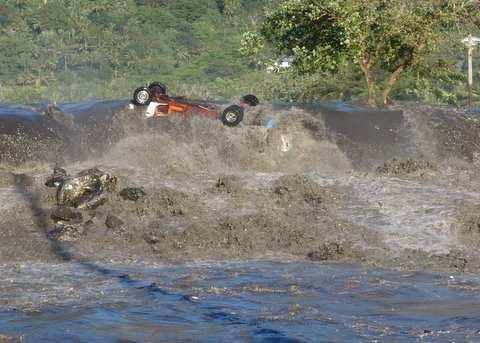
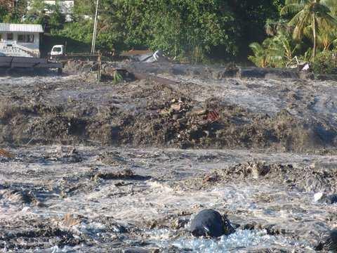
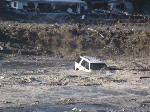
5 Wave run-up / inundation
6 Course of event Tsunami hit during mid tide, Water first receded and left the reef bare, A roaring sound, like a jet engine, 2-3 incoming waves only a few minutes apart, No complete withdrawal between, Second wave being largest, Surge, rather than breaking wave.

7 Wave run-up and inundation Pago Pago, American Samoa


8 Wave run-up and inundation Pago Pago, American Samoa Google Earth

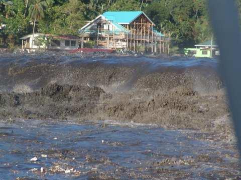
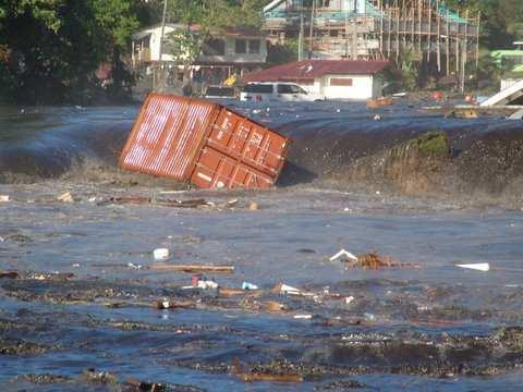
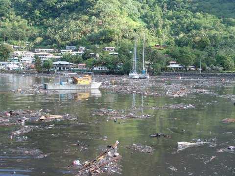
9 Wave run-up and inundation Pago Pago, American Samoa Photos taken by a couple on a yacht in Pago Pago harbour (American Samoa)


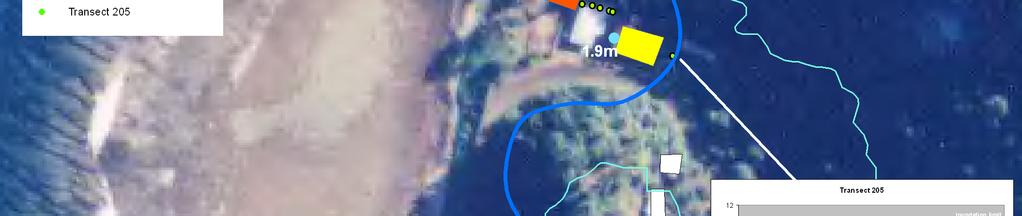
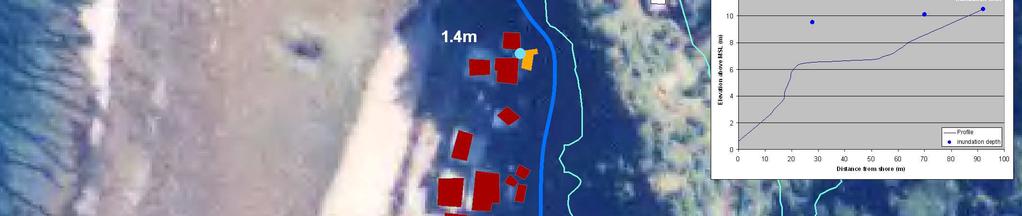
10 Wave run-up and inundation Key questions: Areas affected Wave height / run-up Inundation depth Driving factors

11 Wave run-up and inundation Maximum wave run-up (a. MSL): American Samoa: 10.5 m Samoa: 13.0 m Maximum flow / inundation depth: American Samoa: 5 m Samoa: 6+ m Koshimura et al, 2009 Inland inundation distance: American Samoa: ~620m Samoa: ~350 m Wilson et al, 2009

.")
12 Wave run-up and inundation Wave height dependant on: Near-shore bathymetry, shape of coast, existence of offshore reefs, existence of the offshore islands, Onshore: topography (e.g. roughness, gradient). NZDF, 2009
13 Wave run-up and inundation Lessons learned: Natural warning signs are of key importance for local source tsunamis, First wave may not be the largest, Harbours, bays and inlets often amplify waves, Large variation in in run-up and inundation over short distances, Wide, unbroken reefs lessened inundation and run-up, Intact coastal vegetation reduced flow velocity and depth.
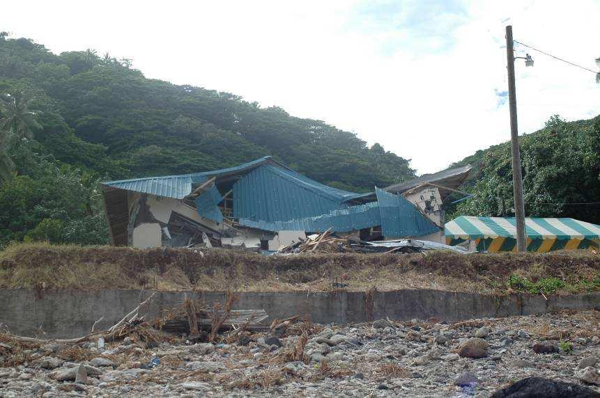
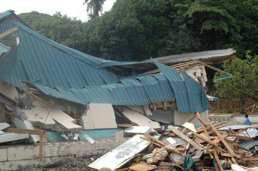
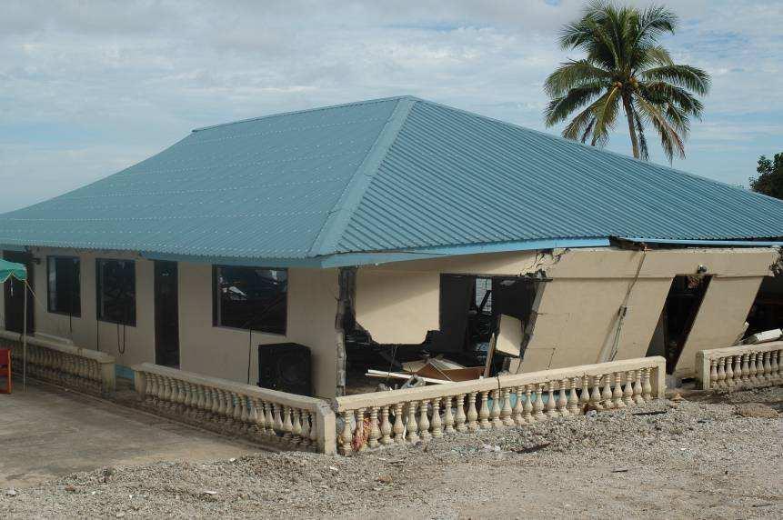
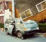
14 Building damage


15 Building damage Relationships between inundation depth, construction type and extent of damage to buildings determined Damage classification: Undamaged Light Damage / Non-structural Damage Minor Damage / Little Structural Damage Only Moderate Damage / Repairable Structural Damage Severe Damage / Irreparable Structural Damage Collapse

16 Poloa / American Samoa


17 Building damage Buildings sustained varying degrees of damage Importance of reinforcement very clear: traditional light timber totally destroyed > 1.5m minimal reinforcement reduced damage significantly Concrete buildings, only minor damage at same inundation depth


18 Building damage >6m Damage was correlated with: depth of tsunami flow, velocity, structural strength, width of reef, ~6m ~3m 1 km 300 m

19 Building damage Damage was correlated with: depth of tsunami flow, velocity, structural strength, width of reef, shielding, density of vegetation


20 amount of debris, condition and height of foundations, quality of building materials used, quality of workmanship, and adherence to the building code Building damage Damage was correlated with: depth of tsunami flow, velocity, structural strength, width of reef, shielding, density of vegetation
")
21 Building damage Lessons learned: Buildings are more likely to survive with less damage if they: are elevated or are a fair distance away from the shore have elevated and sound foundations have reinforced concrete or core-filled concrete block walls, are shielded, and are well constructed and built according to building codes Reinforced buildings in high risk areas (All hazard) Reinforcement for critical facilities such as schools or hospitals should be mandatory Provided by Adam Jowitt
22 Infrastructure
 Water supply (water mains, connections) Septic tanks were displaced Telecommunications (grid) Reinstallation within weeks")
23 Impacts on infrastructure All areas accessible, most roads in reasonable condition Clean-up began within hours Some road erosion A couple of bridges taken out -> temporarily filled Sea walls, river embankments, ports damaged Power network disrupted (transmission grid) Water supply (water mains, connections) Septic tanks were displaced Telecommunications (grid) Reinstallation within weeks (workable level)
24 Economy
25 (Macro-) Economic damage 160 Mio direct damage ($ SAT ) 100 Mio medium-long term losses ($SAT, Early Recovery Framework: 29 Sept. 2009; Worldbank, 2009) 80,000,000 70,000,000 60,000,000 50,000,000 40,000,000 30,000,000 20,000,000 10,000,000 - Losses Damage Direct: Schools, loss of agricultural production / livestock, buildings, shops, hotels, roads & cars
26 (Macro-) Economic damage Indirect: Health -> long term treatment (e.g. trauma) Agriculture -> loss of subsistence production & livestock 80,000,000 70,000,000 60,000,000 50,000,000 40,000,000 30,000,000 20,000,000 10,000,000 - Losses Damage Fisheries -> replacement of boats and gear Tourism -> infrast., accommodation, less tourists Buildings / infrastructure -> rebuilding Not included: costs of disruption, clean-up costs, emergency service, disruption to education, relocation,..
27 (Macro-) Economic damage Not only negative, but also positive impacts: Negative impacts Loss of hotels & restaurants -> $10 Mio/a Loss of wages and salaries - > $11.8 Mio/a Positive impacts Additional visitor arrivals & relief & recovery mission Some loss of income replaced by additional remittances...
28 Environment


29 Environmental damage Tsunami sedimentary deposits widespread (10-20cm, up to 250m inland) Maximum erosion of back beach areas up to ~ 2m, driven by offshore return flow Different levels of environmental damage Pollution from solid waste and sewage Coastal trees provided significant protection to immediate coastal areas, Intact vegetation reduced speed and depth of the waves Coastal trees saved lives Photo taken by NZDF Photo taken by Samuel Etienne
30 Environmental damage Lessons learned: Keep your coastal habitat intact because it can reduce the impacts Clean-up is a huge task (manual in sensitive areas) Pollution from sewage tanks and cars Ecosystems will most likely repair themselves naturally and are unlikely to preserve long-term impacts
31 People
32 People Samoa American Samoa Tonga Fatalities Injuries People affected Displaced people Buildings destroyed 20 villages completely
33 People Tsunami struck at ~7.00am in Samoa and ~7.10am in American Samoa Some people had left to work but most people were in or near their houses Different levels of awareness / preparedness A lack of information about how to react or where to go People expected official warning Confusion about sirens, no protocol


34 People Issues: Clean-up, repair and rebuilding starts within hours / days No time for policy changes, revision of plans Processing of insurance claims Temporary accommodation Schools in high risk areas Immediate needs: sewage, water, clothes, re-install infrastructure Medium-long term needs: Lack of capital, land for relocation, Loss of livelihood Long-term treatment, support
35 Impacts on people Lessons learned: Inform & educate people, it saves lives Don t wait for official warning Identify & sign evacuation routes and assembly areas Establish effective warning system and have protocols Monitor short-term needs Be flexible during response phase Government assistance needed in recovery phase
36 Impacts on people Is Samoa more resilient than New Zealand? Specific local, social, cultural and economic features: People have responsibilities in community (to society) Social network people look after one another System of sharing Land tenure system

37 RiskScape Regional RiskScape A Multi-Hazard Loss Estimation Tool


38 RiskScape Lifelines Economy Disaster impacts $ Damage Businesses Buildings People
39 For more information see: or contact:
Understanding the Tsunami Wave
 The First Tsunami attack on Sri Lanka Krakatoa Island 27 th August 1883 Understanding the Tsunami Wave Generation Propagation Nearshore Transformation Shoreline Entry Inland Dissipation 1 Generation and
THE INEVITABLE RIPPLE 2ND OF APRIL TSUNAMI
 THE INEVITABLE RIPPLE 2ND OF APRIL TSUNAMI Structure Background Preparedness for 2nd of April Response Operations 2nd of April Lessons learnt Future work Hawaii 1957 Background Approx 250,000 people live
For Educational and Non-Profit Use Only!
 This flyer was originally created and published in Japanese by Shizuoka Prefecture, Japan. UNESCO IOC ITIC provides this English translation for portions of the original document with the kind permission
Taranaki Tsunami Inundation Analysis. Prepared for Taranaki Civil Defence Emergency Management Group. Final Version
 Taranaki Tsunami Inundation Analysis Prepared for Taranaki Civil Defence Emergency Management Group Final Version June 2012 AM 12/07 HBRC Plan Number 4362 Asset Management Group Technical Report Prepared
Tsunamis. Tsunamis COMMUNITY EMERGENCY RESPONSE TEAM TSUNAMIS
 Tsunamis Tsunamis Tell the participants that tsunamis are ocean waves that are produced by underwater earthquakes or landslides. The word is Japanese and means harbor wave because of the devastating effects
The frequently asked questions are grouped under headings to make it easier to find information -
 Tsunami Inundation Mapping for Hawke s Bay Frequently Asked Questions The frequently asked questions are grouped under headings to make it easier to find information - General tsunami information Tsunami
CORL Update. July June By Mike King
 2009-2010 CORL Update July 1 2009 June 30 2010 By Mike King At the beginning of CORL s 2009-2010 fiscal year (July 1 to June 30th) we had two funded projects underway. Funding for both was provided by
WHAT IS A TSUNAMI? happens.nz. Long or Strong GET GONE TSUNAMI 101
 WHAT IS A TSUNAMI? A tsunami is a series of powerful waves with strong currents. They are mostly caused by underwater or coastal earthquakes, and sometimes by underwater landslides or volcanic eruptions.
Waves Part II. non-dispersive (C g =C)
") Waves Part II Previously we discussed Surface Gravity Waves Deep Water Waves Shallow Water Waves C g T 2 C g h dispersive (C g =C/2) Definitions: phase speed C= /T= /k non-dispersive (C g =C) group speed
Waves Part II Previously we discussed Surface Gravity Waves Deep Water Waves Shallow Water Waves C g T 2 C g h dispersive (C g =C/2) Definitions: phase speed C= /T= /k non-dispersive (C g =C) group speed
Tsunami Preparedness in the Capital Region
 Tsunami Preparedness in the Capital Region A presentation by: the CRD Local Government Emergency Program Advisory Commission (LG EPAC) and your community emergency programs What is a tsunami? A tsunami
15 GRC AS AN ALTERNATIVE MATERIAL FOR LOW-COST, HIGH-DURABILITY FISHING BOATS
 15 GRC AS AN ALTERNATIVE MATERIAL FOR LOW-COST, HIGH-DURABILITY FISHING BOATS H. W. ASHADI, Material Laboratory, Civil Engineering Dept, University of Indonesia B. SOERYONUGROHO, PT KRAZU Musantara, Indonesia
Case Study 3. Case Study 3: Cebu Island, Philippines MPA Network 10
 Case studies of mpa networks Case Study 3: Cebu Island, Philippines MPA Network 10 Location and background Cebu Island in the Philippines lies in the center of the Visayan Islands, known as an area high
CMS Modeling of the North Coast of Puerto Rico
 CMS Modeling of the North Coast of Puerto Rico PRESENTED BY: Dr. Kelly Rankin Legault, Ph.D., P.E. 1 Dr. Alfredo Torruella, Ph.D. 2 1 USACE Jacksonville District 2 University of Puerto Rico October 2016
Tsunami Preparedness in the Capital Region
 Tsunami Preparedness in the Capital Region A presentation by: the CRD Local Government Emergency Program Advisory Commission (LG EPAC) and your community emergency programs What is a tsunami? A tsunami
MESSOLOGI LAGOON AREA (GREECE)
") MESSOLOGI LAGOON AREA (GREECE) 20 Contact: Kyriakos SPYROPOULOS TRITON Consulting Engineers 90 Pratinou Str. 11634 Athens (GREECE) Tel: +32 10 729 57 61 Fax: +32 10 724 33 58 e-mail: kspyropoulos@tritonsa.gr
MESSOLOGI LAGOON AREA (GREECE) 20 Contact: Kyriakos SPYROPOULOS TRITON Consulting Engineers 90 Pratinou Str. 11634 Athens (GREECE) Tel: +32 10 729 57 61 Fax: +32 10 724 33 58 e-mail: kspyropoulos@tritonsa.gr
WIND SPEED LENGTH OF TIME WIND BLOWS (Duration) DISTANCE OVER WHICH IT BLOWS (Fetch)
 DISTANCE OVER WHICH IT BLOWS (Fetch)") WAVES Up and down movement of ocean surface Transportation of energy across the water over vast distances If not stopped by anything, waves can travel entire oceans Size and speed depend upon: WIND SPEED
WAVES Up and down movement of ocean surface Transportation of energy across the water over vast distances If not stopped by anything, waves can travel entire oceans Size and speed depend upon: WIND SPEED
Puducherry Port Disaster. A Man-Made Made Tsunami. Coastal Erosion at Puducherry. & neighboring beaches of Tamil Nadu
 Puducherry Port Disaster A Man-Made Made Tsunami Coastal Erosion at Puducherry & neighboring beaches of Tamil Nadu Pondicherry Citizens Action Network February 2007 Once upon a time Pondicherry had a beautiful
Cyclone Hazards: waves and storm tide
 Cyclone Hazards: waves and storm tide 1/32 HIGH WAVES TORRENTIAL RAIN (FLOODING) SURGE ON COAST AT CROSSING GALE FORCE WINDS 2/32 Waves and Swell MetEd Comet Program Wind and Wave forecasting https://www.meted.ucar.edu/training_course.php?id=8
COMMENTS FOR THE NSF TSUNAMI WORKSHOP AT HILO, HAWAII, DECEMBER 2006 By Robert L. Wiegel
 COMMENTS FOR THE NSF TSUNAMI WORKSHOP AT HILO, HAWAII, 26-28 DECEMBER 2006 By Robert L. Wiegel 1. Introduction 2. Risk, Adjustment, Mitigation 3. Hilo, Hawaii 4. Designing for Tsunamis: Seven Principles
Montserrat. Wise practices for coping with. i b bea n Se a
 Wise practices for coping with Montserrat Car i b bea n Se a Fisheries Division, Montserrat Physical Planning Department, Montserrat University of Puerto Rico, Sea Grant College Program Caribbean Development
LAB: WHERE S THE BEACH
 Name: LAB: WHERE S THE BEACH Introduction When you build a sandcastle on the beach, you don't expect it to last forever. You spread out your towel to sunbathe, but you know you can't stay in the same spot
Intergovernmental Oceanographic Commission
 Intergovernmental Oceanographic Commission International Tsunami Information Centre Intergovernmental Oceanographic Commission (IOC) United Nations Educational, Scientifi c and Cultural Organization (UNESCO)
A PHYSICAL MODEL STUDY OF TSUNAMI INUNDATION WITH COASTAL INFRASTRUCTURE
 A PHYSICAL MODEL STUDY OF TSUNAMI INUNDATION WITH COASTAL INFRASTRUCTURE Abstract Jennifer Krebs, Edgewood College, Oregon State University Dan Cox (Faculty Mentor), Harry Yeh (Faculty Mentor). The Cascadia
Sea Level Rise and Coastal Flooding Why Waves Matter!
 Sea Level Rise and Coastal Flooding Why Waves Matter! Jason D. Burtner Massachusetts Office of Coastal Zone Management South Shore Regional Coordinator Sea Level Rise and Coastal Storm Damage and Flooding
The Eastern Coromandel Tsunami Strategy. Managing tsunami risks in Mercury Bay
 The Eastern Coromandel Tsunami Strategy Managing tsunami risks in Mercury Bay January 2017 Why are we working on the Eastern Coromandel Tsunami Strategy? The release of the Review of Tsunami Hazard in
FREQUENCY-BASED HARBOR RESPONSE TO INCIDENT TSUNAMI WAVES IN AMERICAN SAMOA. Ziyi Huang 1 and Jiin-Jen Lee 1
 FREQUENCY-BASED HARBOR RESPONSE TO INCIDENT TSUNAMI WAVES IN AMERICAN SAMOA Ziyi Huang and Jiin-Jen Lee September 29, 29 Samoa tsunami attacked Pago Pago Harbor, the major harbor in American Samoa. The
Intergovernmental Oceanographic Commission. International Tsunami Information Centre
 Intergovernmental Oceanographic Commission International Tsunami Information Centre Intergovernmental Oceanographic Commission (IOC) United Nations Educational, Scientific and Cultural Organization (UNESCO)
Prologue. TSUNAMI - To Survive from Tsunami World Scientific Publishing Co. Pte. Ltd.
 Prologue The Indian Ocean tsunami which occurred on December 26, 2004 caused unprecedented disaster and claimed the priceless lives of more than 300,000 persons worldwide. Among the conditions which contributed
SA New Trial Artificial Reef Project
 BACKGROUND PAPER SA New Trial Artificial Reef Project Development of options for the trial artificial reef 1. Summary CONTENTS Each year, an estimated 236,000 South Australians participate in recreational
Environmental Protection on the Gold Coast of Queensland, Australia. 1. What is the appeal of the Gold Coast to tourists?
 Environmental Protection on the Gold Coast of Queensland, Australia Sections 1. What is the appeal of the Gold Coast to tourists? 2. How are Gold Coast visitor trends changing? 3. How can the impacts of
Coastal Inundation. An Overview for TCDC
 Coastal Inundation An Overview for TCDC Rick Liefting Team Leader Regional Hazards and Environmental Compliance Integrated Catchment Management Waikato Regional Council Photo: Sugar Loaf Wharf, Coromandel.
Hydrographic Surveying Methods, Applications and Uses
 Definition: Hydrographic Surveying Methods, Applications and Uses It is the branch of surveying which deals with any body of still or running water such as a lake, harbor, stream or river. Hydrographic
RE: Hurricane Matthew Beach Damage Assessment and Recommendations [CSE 2416]
![RE: Hurricane Matthew Beach Damage Assessment and Recommendations [CSE 2416]](/thumbs/83/87675702.jpg "RE: Hurricane Matthew Beach Damage Assessment and Recommendations [CSE 2416]") October 25, 2016 Iris Hill Town Administrator Town of Edisto Beach 2414 Murray St Edisto Beach SC 29438 RE: Hurricane Matthew Beach Damage Assessment and Recommendations [CSE 2416] Dear Iris, Hurricane
October 25, 2016 Iris Hill Town Administrator Town of Edisto Beach 2414 Murray St Edisto Beach SC 29438 RE: Hurricane Matthew Beach Damage Assessment and Recommendations [CSE 2416] Dear Iris, Hurricane
LOCAL COASTAL PROGRAM UPDATE
 LOCAL COASTAL PROGRAM UPDATE Agenda Meeting #1 General Information (1 1:45 pm) Introductions and Background Grants involved What is a Local Coastal Program? What is required? LCP Update tasks and schedule
The Dynamic Coast. Right Place Resources. A presentation about the interaction between the dynamic coast and people
 The Dynamic Coast Houses threatened by coastal erosion in California Right Place Resources A presentation about the interaction between the dynamic coast and people For the rest of the presentations in
Chapter 3 Field Survey Report on the 2004 Indian Ocean Tsunami along the Southwestern Coast of Sri Lanka
 Chapter 3 Field Survey Report on the 2004 Indian Ocean Tsunami along the Southwestern Coast of Sri Lanka 3.1 Introduction A huge earthquake with a magnitude of 9.0 took place to the northwest of Sumatra
Delaware Chapter Surfrider Foundation - Indian River Inlet Monitoring
 Delaware Chapter Surfrider Foundation - Indian River Inlet Monitoring In 2012, the Delaware Surfrider Foundation Chapter formed the Surf Quality and Access Committee to focus on issues such as surf spot
Leaning Into Adaptation
 www.marinslr.org Leaning Into Adaptation GFNMS Ocean Summit, May 17, 2016 Jack Liebster, Planning Manager, Marin County Marin County C-SMART Sea Level Rise Adaptation Process Evaluate Science Info. Implement
Emergency Coastal Protection Works Practical Lessons For The Future From The Past
 Emergency Coastal Protection Works Practical Lessons For The Future From The Past Angus Jackson1 Principal Engineer, International Coastal Management a.jackson@coastalmanagement www.coastalmanagement.com.au
A Survey of Biodegradable and Non Biodegradable Debris on. Dominica s Coastal Zones
 A Survey of Biodegradable and Non Biodegradable Debris on Dominica s Coastal Zones Heather edina, Heather Woods, ichele Horner, Patricia Jimenez, Zac Zemanek Dominica 2011 Abstract: This report is a summary
EROSION MECHANICS OF A CARBONATE- TOMBOLO BEACH IN MIYAKOJIMA ISLAND, OKINAWA PREFECTURE, JAPAN.
 EROSION MECHANICS OF A CARBONATE- TOMBOLO BEACH IN MIYAKOJIMA ISLAND, OKINAWA PREFECTURE, JAPAN. Ryuichiro NISHI 1, Takaaki UDA 2, Akio KIKUCHI 3 and Kou FURUIKE 4 1) Associate Prof. Dept. of Ocean Civil
Geology of the Hawaiian Islands
 Geology of the Hawaiian Islands Class 24 8 April 2004 Any Questions? Rise and fall of sea level and its effect on Hawai`i Sea level Has fluctuated up and down many times in the geologic past Evidence?
LAKKOPETRA (GREECE) EUROSION Case Study. Contact: Kyriakos SPYROPOULOS. TRITON Consulting Engineers. 90 Pratinou Str Athens (GREECE)
 EUROSION Case Study. Contact: Kyriakos SPYROPOULOS. TRITON Consulting Engineers. 90 Pratinou Str Athens (GREECE)") LAKKOPETRA (GREECE) Contact: Kyriakos SPYROPOULOS TRITON Consulting Engineers 90 Pratinou Str. 11634 Athens (GREECE) Tel: +32 10 729 57 61 Fax: +32 10 724 33 58 e-mail: kspyropoulos@tritonsa.gr 19 1 1.
LAKKOPETRA (GREECE) Contact: Kyriakos SPYROPOULOS TRITON Consulting Engineers 90 Pratinou Str. 11634 Athens (GREECE) Tel: +32 10 729 57 61 Fax: +32 10 724 33 58 e-mail: kspyropoulos@tritonsa.gr 19 1 1.
Geology 15 Activity 5 A Tsunami
 Materials: Marigram recorded in San Diego, May 23, 1960. Travel Time Graph To San Diego. Answer sheet Source of information: Lander, James F., Patricia A. Lockridge and Michael J. Kozuch, s Affecting the
TRANSPORT PUBLIC SAFETY SERVICES THAT SUPPORT COMMUNITIES. Provide access to, from and for emergency services
 Transport - 128 - Road Network KEY FACTS Council operates and maintains a network of some 2,53 km which includes: o 864 km of sealed roads o 1,666 km of unsealed roads o 7 bridges and large culverts o
TSUNAMI WARNINGS - A GUIDE FOR MEDIA - August 2018
 TSUNAMI WARNINGS - A GUIDE FOR MEDIA - August 2018 Tsunami that affect New Zealand may be generated on, near, or far from our shores. New Zealand is at risk from tsunami that happen near us, and around
STATUS REPORT FOR THE SUBMERGED REEF BALL TM ARTIFICIAL REEF SUBMERGED BREAKWATER BEACH STABILIZATION PROJECT FOR THE GRAND CAYMAN MARRIOTT HOTEL
 August 23 STATUS REPORT FOR THE SUBMERGED REEF BALL TM ARTIFICIAL REEF SUBMERGED BREAKWATER BEACH STABILIZATION PROJECT FOR THE GRAND CAYMAN MARRIOTT HOTEL performed by Lee E. Harris, Ph.D., P.E. Consulting
Statement of the World Forum of Fisher People To the FAO Conference on Small Scale Fisheries, Bangkok, 2008
 Statement of the World Forum of Fisher People To the FAO Conference on Small Scale Fisheries, Bangkok, 2008 INTRODUCTION Around the world, small-scale, artisanal and indigenous fisher people are standing
Coastal Hazards Study
 Coastal Hazards Study 2212 Beach Boulevard, Pacifica Prepared for: EXECUTIVE SUMMARY City of Pacifica 170 Santa Maria Ave Pacifica, CA 94044 Prepared by: moffatt & nichol 2185 N. California Blvd. Walnut
Geology 10 Activity 8 A Tsunami
 Geology 10 Activity 8 A Materials: Marigram recorded in San Diego, May 23, 1960. Travel Time Graph To San Diego. Answer sheet Source of information: Lander, James F., Patricia A. Lockridge and Michael
GONE! Coastal Erosion Happens During Storms! Why Worry About Coastal Setbacks? Goals for Today
 RI Regulatory Setbacks & Buffers: Coastal Zone Management Issues New England Onsite Wastewater Training Program @ URI OWT 155 November 21, 2013 Goals for Today Understand the impacts of storms, coastal
INTRODUCTION TO COASTAL ENGINEERING
 The University of the West Indies Organization of American States PROFESSIONAL DEVELOPMENT PROGRAMME: COASTAL INFRASTRUCTURE DESIGN, CONSTRUCTION AND MAINTENANCE A COURSE IN COASTAL DEFENSE SYSTEMS I CHAPTER
RI Regulatory Setbacks & Buffers: Coastal Management Issues
 RI Regulatory Setbacks & Buffers: Coastal Management Issues New England Onsite Wastewater Training Program @ URI OWT 155 - November 29, 2012 James Boyd - Coastal Policy Analyst Photo: October 30, 2012
County of Santa Barbara Permit Option Analysis Goleta Beach JULY 13, 2017
 County of Santa Barbara Permit Option Analysis Goleta Beach JULY 13, 2017 Introduction 2 Goleta Beach Park welcomes 1.5 million visitors annually Amenities include: Picnic Areas and Group Areas w/bbqs
Q1. What are the primary causes/contributors to coastal erosion at Westshore and the concept of longshore / littoral drift.
 Q1. What are the primary causes/contributors to coastal erosion at Westshore and the concept of longshore / littoral drift. In order of (timing related) contribution to present problem 1. Beach is too
consulting engineers and scientists
 consulting engineers and scientists Coastal Processes Presented by: January 9, 2015 Varoujan Hagopian, P.E. F.ASCE Senior Consultant, Waterfront Engineer Living Shoreline Workshop Lets Remember Why We
The Kingston Harbour Fisheries
 The Kingston Harbour Fisheries Presenter: G. Andre Kong, Director of Fisheries November 6, 2003, Conference Centre. KINGSTON HARBOUR S S CP S CP CP CP CP RF Arrangement of Presentation Major elements of
Fisheries Livelihood Support
 Public Disclosure Authorized Public Disclosure Authorized Public Disclosure Authorized Public Disclosure Authorized PROGRAM PROFILE Sustainable Fisheries A component of Tamil Nadu and Puducherry Coastal
The Sand Beaches of New Hampshire and Maine
 The Sand Beaches of New Hampshire and Maine Beach Preservation and Erosion Control Photographs provided by Joe Kelly and Steve Adams Cover photo: Reid State Park, ME Introduction The sand beaches of New
COASTAL ENVIRONMENTS. 454 lecture 12
 COASTAL ENVIRONMENTS Repeated movement of sediment & water constructs a beach profile reflecting the balance between average daily or seasonal wave forces and resistance of landmass to wave action Coasts
NYS Coastal Waters. Water Resources of NYS: THE NATURE of the COASTAL ZONE. NYS Coastal Waters. NYS Coastal Atlas. Coastal Zone Management 10/10/2014
 Water Resources of NYS: THE NATURE of the COASTAL ZONE NYS Coastal Waters NYS is the only state to border the Atlantic Ocean and the Great Lakes (Lakes Erie and Ontario). Great Lakes shoreline: 577 miles
UNDERSTANDING STORM SURGE
 The Education Program at the New Jersey Sea Grant Consortium 22 Magruder Road, Fort Hancock, NJ 07732 (732) 872-1300 www.njseagrant.org UNDERSTANDING STORM SURGE ACTIVITY 6 SURGE OF THE STORM http://secoora.org/classroom/virtual_hurricane/surge_of_the_storm>
Warm-up # 7 A day 5/17 - B day 5/18 UPDATE YOUR TABLE OF CONTENTS
 Warm-up # 7 A day 5/17 - B day 5/18 UPDATE YOUR TABLE OF CONTENTS Question: List all examples of surface water on Earth. Answer: Rivers and streams, lakes and reservoirs, (ponds) wetlands, estuaries and
Derelict fishing gear and other marine debris: Australia and the Asia Pacific
 Derelict fishing gear and other marine debris: Australia and the Asia Pacific 9 June 2005 UNICPOLOS, New York Ilse Kiessling National Oceans Office Department of Environment and Heritage, Australia 1 Marine
The Failure of the Kamaishi Tsunami Protection Breakwater
 PT-13: Coastal and Ocean Engineering ENGI.8751 Undergraduate Student Forum Faculty of Engineering and Applied Science, Memorial University, St. John s, NL, Canada March, 2013 Paper Code. (PT-13 - Tucker)
LOCALLY CONCENTRATED SEVERE BEACH EROSION ON SEISHO COAST CAUSED BY TYPHOON T0709
 F-4 Fourth International Conference on Scour and Erosion 2008 LOCALLY CONCENTRATED SEVERE BEACH EROSION ON SEISHO COAST CAUSED BY TYPHOON T0709 Yoshimitsu TAJIMA 1 and Shinji SATO 2 1 Member of JSCE, Associate
Door County, WI Coastal Hazard Analysis Flood Risk Review Meeting. August 21, 2017
 Door County, WI Coastal Hazard Analysis Flood Risk Review Meeting August 21, 2017 Agenda Introductions Coastal Flood Risk Study and Mapping Program Current Status Technical Overview of Study and Mapping
Lee E. Harris, Ph.D., P.E. Assoc. Professor of Ocean Engineering. Doug Bowlus and Ashley Naimaster Ocean Engineering Graduate Students
 FLORIDA TECH OCEAN ENGINEERING PROFESSOR LEE HARRIS AND HIS GRADUATE STUDENTS ASSIST WITH POST-HURRICANE IVAN CORAL REEF RESTORATION IN THE CAYMAN ISLANDS Lee E. Harris, Ph.D., P.E. Assoc. Professor of
City of Del Mar Local Coastal Plan (LCP) Amendment for Sea Level Rise and Coastal Flooding
 Amendment for Sea Level Rise and Coastal Flooding") City of Del Mar Local Coastal Plan (LCP) Amendment for Sea Level Rise and Coastal Flooding 6/22/17 Presentation to Sea Level Rise Stakeholder- Technical Advisory Committee (STAC) Nick Garrity, P.E. Lindsey
City of Del Mar Local Coastal Plan (LCP) Amendment for Sea Level Rise and Coastal Flooding 6/22/17 Presentation to Sea Level Rise Stakeholder- Technical Advisory Committee (STAC) Nick Garrity, P.E. Lindsey
Bay of Fundy Estuary Profile
 s The is a sub-basin of the Bay of Fundy along the northwestern shore of Nova Scotia and at the western end of the Annapolis Valley. The Annapolis River is the major water source flowing into the estuary.
Bay County, MI Coastal Hazard Analysis Flood Risk Review Meeting. May 14, 2018
 Bay County, MI Coastal Hazard Analysis Flood Risk Review Meeting May 14, 2018 Agenda Introductions Coastal Flood Risk Study and Mapping Program Current Status Technical Overview of Study and Mapping Floodplain
Samoa National Tuna Fishery Report. Dan Su a, Peter Watt, and Roseti Imo
 SCTB15 Working Paper NFR-20 Samoa National Tuna Fishery Report Dan Su a, Peter Watt, and Roseti Imo Fisheries Division Ministry of Agriculture, Forests, Fisheries and Meteorology Apia, Samoa Samoa National
2016 NC Coastal Local Governments Annual Meeting
 2016 NC Coastal Local Governments Annual Meeting Coastal Flood Study Modeling and Mapping 101 April 21, 2016 Tom Langan, PE, CFM Engineering Supervisor NCEM Floodplain Mapping Program FEMA Coastal Flood
Ocean Waves. Capillary. Gravity. Wind generated. Tides Tsunamis Seiches
 Ocean Waves Capillary Wind generated Gravity Tides Tsunamis Seiches Capillary waves are driven by the surface tension produced by electrically polarized water molecule San Pedro Lighthouse Waves are alternate
The events associated with the Great Tsunami of 26 December 2004 Sea Level Variation and Impact on Coastal Region of India
 The events associated with the Great Tsunami of 26 December 2004 Sea Level Variation and Impact on Coastal Region of India Satish R. Shetye National Institute of Oceanography, Goa Tsunamis are shallow-water
ALTERNATIVES FOR COASTAL STORM DAMAGE MITIGATION AND FUNCTIONAL DESIGN OF COASTAL STRUCTURES
 The University of the West Indies Organization of American States PROFESSIONAL DEVELOPMENT PROGRAMME: COASTAL INFRASTRUCTURE DESIGN, CONSTRUCTION AND MAINTENANCE A COURSE IN COASTAL DEFENSE SYSTEMS I CHAPTER
Intergovernmental Oceanographic Commission. International Tsunami Information Center
 W W W.T S U N A M I W AV E.I N F O Intergovernmental Oceanographic Commission INTERNATIONAL TSUNAMI INFORMATION CENTER International Tsunami Information Center United Nations Educational, Scientific and
EVALUATION OF TSUNAMI FLUID FORCE ACTING ON THE BRIDGE DECK
 JOINT CONFERENCE PROCEEDINGS 9th International Conference on Urban Earthquake Engineering/ th Asia Conference on Earthquake Engineering March -8,, Tokyo Institute of Technology, Tokyo, Japan EVALUATION
Climate Change Risks for Victoria s Surf Coast
 Climate Change Risks for Victoria s Surf Coast Craig A, Clifton 1, Dan Ware 1, Simon Coverdale 2 and Chloe Hanson-Boyd 1 1 Sinclair Knight Merz, Melbourne, AUSTRALIA. email: cclifton@globalskm.com 2 Great
Name Class Date. Use the terms from the following list to complete the sentences below. Each term may be used only once. Some terms may not be used.
 Assessment Chapter Test B The Movement of Ocean Water USING KEY TERMS Use the terms from the following list to complete the sentences below. Each term may be used only once. Some terms may not be used.
TITLE: North Carolina s Changing Shorelines. KEYWORDS: erosion - shorelines - mapping - sustainability
 UNC Coastal Studies Institute Teacher Resources 1 TITLE: North Carolina s Changing Shorelines KEYWORDS: erosion - shorelines - mapping - sustainability Changing shorelines impact coastal infrastructure.
M. Takezawa & Y. Maeno Department of Civil Engineering, College of Science & Technology Nihon University, 1-8 Kandasurugadai Chiyodaku, Tokyo, Japan
 Survey of small fisheries in Japan M. Takezawa & Y. Maeno Department of Civil Engineering, College of Science & Technology Nihon University, 1-8 Kandasurugadai Chiyodaku, Tokyo, Japan Abstract The coast
Recreational Saltwater Fishing Industry Trends and Economic Impact January 2007
 Document was created exclusively for RISAA and the information contained herein is not to be disclosed without their expressed permission Recreational Saltwater Fishing Industry Trends and Economic Impact
Inspection of Clarence City Beaches following Winter 2011 Storm Events
 18 July 2011 WRL Ref: WRL10086TDS L20110718 Messrs P Watson & I Preece Clarence City Council PO Box 96 Rosny Park TAS 7018 By email: pwatson@ccc.tas.gov.au ipreece@ccc.tas.gov.au Dear Phil/Ian, Inspection
31. Rosses Point Mini-Plan
 County Development Plan 2017-2023 Volume 2, Chapter 31 Rosses Point Mini-Plan 31. Rosses Point Mini-Plan Village profile Rosses Point is a coastal settlement located approximately 8 km north-west of Sligo
Modeling Beach Erosion
 Ocean Lecture & Educator s Night May 16, 2012 Modeling Beach Erosion Below is an overview of the activity Modeling Beach Erosion (New Jersey Sea Grant Consortium, Education Program) to incorporate information
Bathing Water Profile - Carne (2017)
") Bathing Water Profile - Carne (2017) Bathing Water: Bathing Water Code: Local Authority: River Basin District: Monitoring Point: Carne IESEBWC050_0000_0300 Wexford County Council South Eastern 312952E,
Bathing Water Profile - Carne (2017) Bathing Water: Bathing Water Code: Local Authority: River Basin District: Monitoring Point: Carne IESEBWC050_0000_0300 Wexford County Council South Eastern 312952E,
Assessment of flooding on low-elevation reef-lined coasts
 Assessment of flooding on low-elevation reef-lined coasts Ap van Dongeren, Deltares, Delft, The Netherlands With Curt Storlazzi, USGS, Santa Cruz, USA Impact on coral reef-lined islands and coasts Coral
Shoreline Response to an Offshore Wave Screen, Blairgowrie Safe Boat Harbour, Victoria, Australia
 Shoreline Response to an Offshore Wave Screen, Blairgowrie Safe Boat Harbour, Victoria, Australia T.R. Atkins and R. Mocke Maritime Group, Sinclair Knight Merz, P.O. Box H615, Perth 6001, Australia ABSTRACT
Community vulnerability to elevated sea level and coastal tsunami events in Otago
 Community vulnerability to elevated sea level and coastal tsunami events in Otago Otago Regional Council Private Bag 1954, 70 Stafford St, Dunedin 9054 Phone 03 474 0827 Fax 03 479 0015 Freephone 0800
The Case of the Disappearing Shoreline
 Name The Case of the Disappearing Shoreline Humans change the earth's climate in many ways. One change is the increase of carbon dioxide in the atmosphere. As we burn more fossil fuels, we release more
ALTERNATIVES FOR COASTAL STORM DAMAGE MITIGATION
 ALTERNATIVES FOR COASTAL STORM DAMAGE MITIGATION Dave Basco Old Dominion University, Norfolk, Virginia, USA National Park Service Photo STRUCTURAL (changes to natural, physical system) hardening (seawalls,
The Surge of the Storm By Margaret Olsen and Katie Greganti
 The Surge of the Storm By Margaret Olsen and Katie Greganti Grade Level: 5-12 Type of Activity: Hands on Focus Question: How does a hurricane s storm surge of a hurricane affect the low-lying areas along
Coastal management has lagged behind the growth in population leading to problems with pollution
 Fifty percent of the population of the industrialized world lives within 100 km of a coast. Coastal management has lagged behind the growth in population leading to problems with pollution and natural
NORTHERN CELL OPTIONS SHORTLIST RECOMMENDATIONS
 OPTIONS SHORTLIST RECOMMENDATIONS Coastal Unit C: Bayview Options recommended for MCDA scoring. Status quo. Planting 3. Renourishment (gravel) 6. Beach-scraping 7. Restore shingle crest. Inundation accommodation
4/20/17. #32 - Coastal Erosion Case Histories - Lake Michigan
 Writing Assignment Due Monday by 11:59 pm #32 - Coastal Erosion Case Histories - Lake Michigan See main class web pages for detailed instructions Submit papers Illinois Compass No copying: Compass will
VIMS CCRM Coastal Management Decision Tools. Decision Tree for Undefended Shorelines and Those with Failed Structures
 VIMS CCRM Coastal Management Decision Tools Decision Tree for Undefended Shorelines and Those with Failed Structures Center for Coastal Resources Management Virginia Institute of Marine Science Gloucester
Beach profile surveys and morphological change, Otago Harbour entrance to Karitane May 2014 to June 2015
 Beach profile surveys and morphological change, Otago Harbour entrance to Karitane May 2014 to June 2015 Prepared for Port Otago Ltd Martin Single September 2015 Shore Processes and Management Ltd Contact
Prepare 2008 Olympic Sailing Events. Sailing Sub-committee of BOCOG Qingdao
 Prepare 2008 Olympic Sailing Events Sailing Sub-committee of BOCOG Qingdao 2006.1.16 1 Contents About the city About Us What have been done Olympiad, Qingdao 2 About the city Qingdao, a charming coastal
DELAWARE S VULNERABLE COASTAL AREAS. DELAWARE INLAND BAYS and DELAWARE BAY RECONNAISSANCE STUDY
 DELAWARE S VULNERABLE COASTAL AREAS and the DELAWARE INLAND BAYS and DELAWARE BAY RECONNAISSANCE STUDY Kimberly K. McKenna, PG Delaware Dept. of Natural Resources & Environmental Control Division of Watershed