Influence of oceanographic processes on coastal erosion, morphology and inundation
|
|
|
- Brianna Briggs
- 5 years ago
- Views:
Transcription

1 FACULTY OF ENGINEERING, COMPUTING AND MATHEMATICS Influence of oceanographic processes on coastal erosion, morphology and inundation Charitha Pattiaratchi School of Civil, Environmental and Mining Engineering & UWA Oceans Institute,


2 Acknowledgements Ivan Haigh*, Cyprien Bosserelle, Shari Gallop*, Matt Eliot, Sarath Wijeratne School of Civil, Environmental and Mining Engineering, UWA *National Oceanography Centre, Southampton, UK Tony Lamberto, Reena Lowry Department of Transport


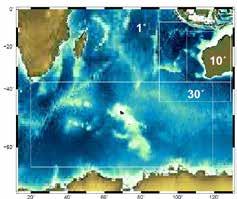
3 Coastal impacts From 2001 to 2011, the population of Western Australia increased by 24%, and Greater Perth by 26% concentrated in the coastal zone. 2020, 2050, 2100??


4 Coastal impacts Climate Change Landslides Earthquakes Astronomical Tides Longer term sea level variability (non-tidal) Storm systems Tsunamis Storm Surges Surface Waves Sea level changes Coastal flooding Beach Stability Coastal Amenity

5 Tsunamis: Seismic and Meteorological Max: 0.60m Max: 0.72m
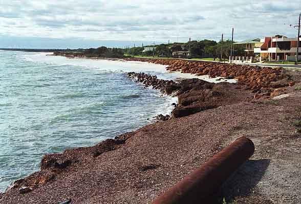
6 Coastal Infrastructure

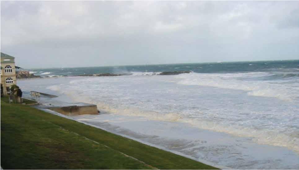
7 Cottesloe


8 Port Beach Fremantle 2003

9 Geordie Bay Rottnest 2003 Matt Eliot

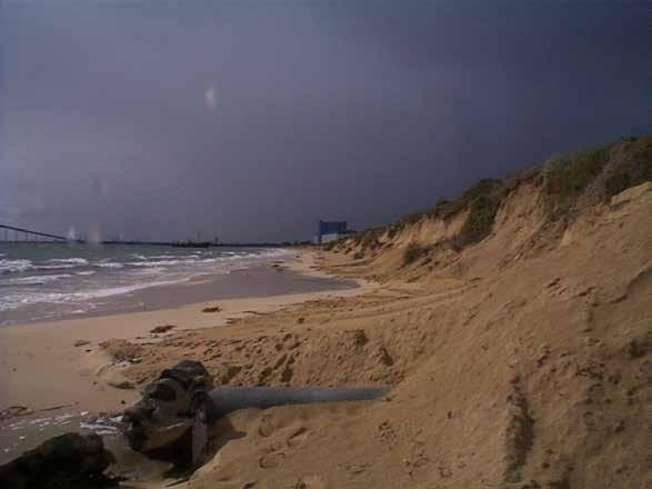
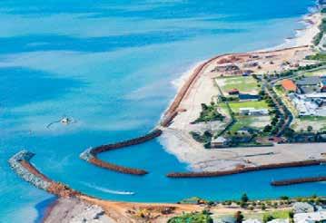
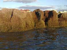
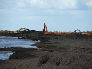
10 Port Geographe 2003
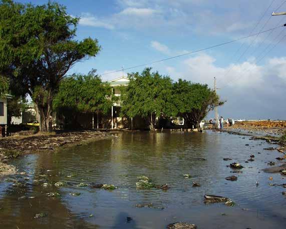
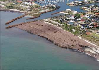
11 Rockingham 2003
12 Beach variability
13 What would this beach look like in 2100?

14 Beach variability Binningup 90m 0.9m 3m 42m

15 Perched Beaches Start Summer N Yanchep Lagoon November


16 Forcing: a range of spatial scales Astronomical Meteorological Oceanic: Indian + Pacific Oceanic: Atlantic + Southern


")

17 Beach Basin Scale Shelf Scale Beach Scale Wave Climate Storm Surges Mean sea level ENSO (El Nin0/La Nina) Seasonal + Inter-annual Nodal tides Relative MSL


18 Hindcasts 40-year climatology NCEP Re-analysis Ocean Wave model 60-year climatology Tide &Storm surge model Bosserelle et al., 2012


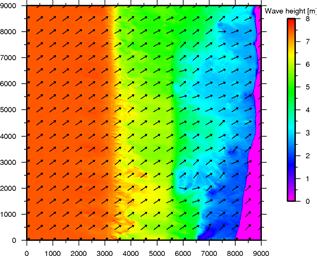
19 Wave climate variability nearshore Nearshore wave climate Offshore wave climate Effect of nearshore wave climate variability on sediment transport on beaches 3
20 Where does the wave energy come from? Instituto de Hidráulica Ambiental Universidad de Cantabria, Spain

21 Mean wave height (40 year)

22 Trends in mean Hs 0.24 over 40 years

23 Max wave heights: 1975

24 Max wave height: 1996

25 Max wave height 2006

26 Annual 90 th percentile time slice Southward shift

27 Evolution of long-term wave climate in WA Increase in number and severity of storms in southern Indian Ocean No trends in extreme wave events off WA but increase in swell height Large wave event tracks shifted southward 7m 8m 9m 10m Bosserelle et al. (2011)
 = Tide(t) + Surge(t) + Mean")

28 Sea Level Fluctuations: Fremantle Sea Level (t) = Tide(t) + Surge(t) + Mean Sea Level(t) Range = 2.22m Highest WL +2.12m CD Daily Range m Lowest WL 0.1m CD
29 Processes contributing to water level variability at Fremantle Water level range (m) seiches tsunami diurnal tides surges annual inter-annual nodal tides global warming / 100 yr 0.0 Pattiaratchi et al. (2014)
30 Fremantle Tide Spectrum


31 Long-period Tides Fremantle 18.6 years Broome 4.4 years
32 Fremantle High WL Exceedance (cumulative) Sea Level Rise Shows bursts of activity, and progressive change Matt Eliot, 2012


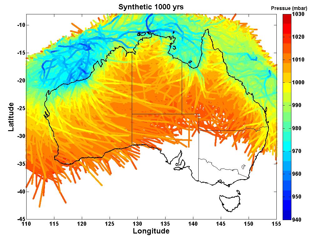
33 Sea level hindcasts NCEP: Tropical Cyclones Global tidal model ~75,ooo simulations equivalent to 10,000 years Total Sea level

34 Storm Surges


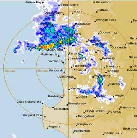
35 Storm track categories Storm track Start of storm track Time of max surge 35

36 Decadal changes 36
 1,000 ± 500 km Surge - 2-5 days Several hundred")

37 Extreme Events storm surge Extra-tropical Tropical (cyclones) 1,000 ± 500 km Surge days Several hundred km Sprawling geometry Apr-Aug 500 ± 200 km Surge - up to half a day Usually < 200 km Compact and nearly symmetrical Nov-Apr


38 Tropical storms 10,000 year climatology
39 1:1000ARI: total water level (tropical + extra-tropical) Haigh et al.,, 2013, 2014


40 Study Team: Ivica Janeković and Yasha Hetzel

41 Continental Shelf Wave generation Summer: Tropical cyclones Winter + summer: pressure systems


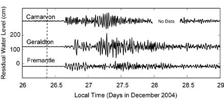
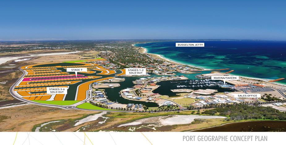
42 TC Bianca: 30 January 2011
43 Continental Shelf Waves (TC Bianca) Tropical low Mihanovic & Pattiaratchi, 2014


44 Tropical Cyclone Bianca: Jan Flooding around the Swan river typically commences at about 1.6m CD, with flooding of the Kwinana Freeway at Como around 1.8 m CD.


45 Tropical Cyclone Bianca Yanchep Beach 17 January 31 January 5 m

46 Tropical Cyclone Bianca Perth CBD?
47 Fremantle Sea Level: Mean rate of increase: 1.54 mm/year Mean global rate: 1.88 mm/year ( ) (IPCC R4) Global mean sea level increased throughout the 20th century and in 2012 was 225 mm higher than in 1880: 1.7 mm/year (March : CSIRO & BoM State of the Climate Report)
48 Sea Level Variability (phase) Fremantle (5 yr running means) Mean Sea Level Astronomical Tide Storm Surge Observed Tide
49 Fremantle Sea Level: Acceleration?
50 Global mean sea level rise Acceleration detection timescale 0.5 m 1.0 m 1.5 m 2.0 m It will be several decades before a change in acceleration in individual TG records are detected. This is mainly due to inter-annual to multi-decadal variability Haigh et al., 2014, Nature Communications


51 Coastal Modelling: multiple scales from ocean basins to beaches Basin scale: Meteorological forcing
52 Port Geographe: new marina layout to prevent seaweed accumulations $ 30 million Project


53 Port Geographe 16 October 2014


54 Yanchep lagoon: effect of a severe storm a


55 Yanchep lagoon: effect of a severe storm

56 Yanchep lagoon: how does the sand come over the reef?
")
57 Yanchep lagoon (1974 to 2008)
")
58 Yanchep lagoon (1974 to 2008)
59 Rockingham 40 PSM Rockingham Change in Shoreline position with time Position of MSL relative to 1974 (m) Year PSM Rockingham Change in Shoreline position with time (months) Position of MSL relative to 1974 (m) Mar Apr May-0320-May Jun Jul Aug-03 Ailbhe Travers


60 Summary Energy incident at the beach has a range of spatial and temporal scales Wave energy is increasing Sea level has many components and strongly influences beach stability. Expect a decrease in mean water levels over next 10 years due to tidal effects Implications for coastal flooding, beach stability and coastal infrastructure Not a time to be complacent!!!
61 Thank You
Climate change effects on fisheries: implications for management Nick Caputi
 NCCARF Climate change effects on fisheries: implications for management Nick Caputi Alan Pearce & Rod Lenanton December 2009 Overview 1. Overall environmental trends 2. Environmental effect on fisheries
Nature Of Marine winds, Waves and Swells over West African Coasts Case study of Victoria Island beach in Lagos, Nigeria
 Nature Of Marine winds, Waves and Swells over West African Coasts Case study of Victoria Island beach in Lagos, Nigeria By S. O. Gbuyiro and E. Olaniyan Marine Unit, Nigeria Meteorological Agency, Lagos
Sand Bank Passage. Fiji nearshore wave hindcast ' ' 19 00'
 Sand Bank Passage Fiji nearshore wave hindcast 1 00' 1 00' 1 30' 1 00' 177 00' 177 30' 17 00' 17 30' 17 30' Figure 1. Location maps of the site. The map on the left shows the region. The map on the right
Coastal management has lagged behind the growth in population leading to problems with pollution
 Fifty percent of the population of the industrialized world lives within 100 km of a coast. Coastal management has lagged behind the growth in population leading to problems with pollution and natural
Mango Bay_Resort. Fiji nearshore wave hindcast ' ' 19 00'
 Mango Bay_Resort Fiji nearshore wave hindcast 1 00' 1 30' 1 00' 177 00' 177 30' 17 00' 17 30' Figure 1. Location maps of the site. The map on the left shows the region. The map on the right shows the island
Kavala Bay. Fiji nearshore wave hindcast ' ' 19 00'
 Kavala Bay Fiji nearshore wave hindcast 1 00' 19 00' 1 30' 19 00' 1 00' 1 30' 1 00' 1 30' 1 30' Figure 1. Location maps of the site. The map on the left shows the region. The map on the right shows the
3/9/2013. Build house on cliff for a view of the ocean - be one with said view Pearson Education, Inc. Shorelines: summary in haiku form
 Introduction to Environmental Geology, 5e Edward A. Keller Shorelines: summary in haiku form Chapter 11 Coastal Processes Lecture Presentation prepared by X. Mara Chen, Salisbury University Build house
Chapter - Oceans and Coasts
 Chapter - Oceans and Coasts Discussion: What do oceans contribute to the environment of Earth? How do Earth s major systems relate to the oceans? Oceans and Coasts Oceans are important - Thermal regulation
Australian Coastal Councils Conference
 Australian Coastal Councils Conference Kiama March 2019 Where Has My Beach Gone? (and what can I do about it?) Dr Andrew McCowan Water Technology Where Has My Beach Gone? Where Has My Beach Gone? Where
Baird. Innovation, Excellence & Service Oceans, Lakes & Rivers
 Profile Capabilities Innovation, Excellence & Service Oceans, Lakes & Rivers Baird provides professional engineering and technical services related to the design of coastal structures and facilities that
The role of large-scale modes of climate variability on the Cape Point wave record
 GODAE OceanView 5th COSS-TT meeting, Cape Town 2017 The role of large-scale modes of climate variability on the Cape Point wave record Jennifer Veitch1, Andrew Birkett2, Juliet Hermes1, Christo Rautenbach,
Avaavaroa passage. Rarotonga nearshore wave hindcast 21 09' 21 12' 21 15' 21 18' ' ' ' '
 Avaavaroa passage Rarotonga nearshore wave hindcast 21 09' 21 ' Fuel Pipeline Avatiu Passage Black Rock Avarua Passage Pue Tupapa Papua Passage Avaavaroa Passage 21 15' Ngatangiia Passage onga Wave Hotspot
Managing and Adapting to Sea Level Rise in Egypt. Coastal Research Institute
 Managing and Adapting to Sea Level Rise in Egypt Coastal Research Institute Global Perspective Climate-induced increases in sea level are caused by thermal expansion of the oceans and melting of land ice
Tropical Cyclone Climate in the Asia- Pacific Region and the Indian Oceans
 Tropical Cyclone Climate in the Asia- Pacific Region and the Indian Oceans Johnny Chan Guy Carpenter Asia-Pacific Climate Impact Centre School of Energy and Environment City University of Hong Kong Annual
MODELING OF CLIMATE CHANGE IMPACTS ON COASTAL STRUCTURES - CONTRIBUTION TO THEIR RE-DESIGN
 Proceedings of the 14 th International Conference on Environmental Science and Technology Rhodes, Greece, 3-5 September 2015 MODELING OF CLIMATE CHANGE IMPACTS ON COASTAL STRUCTURES - CONTRIBUTION TO THEIR
April 7, Prepared for: The Caribbean Disaster Emergency Response Agency Prepared by: CEAC Solutions Co. Ltd.
 April 7, 2006 Prepared for: The Caribbean Disaster Emergency Response Agency Prepared by: Introduction CEAC Solutions Co. Ltd was commissioned in May 2005 to prepare coastal beach erosion hazard maps for
OCEANOGRAPHY STUDY GUIDE
 OCEANOGRAPHY STUDY GUIDE Chapter 2 Section 1 1. Most abundant salt in ocean. Sodium chloride; NaCl 2. Amount of Earth covered by Water 71% 3. Four oceans: What are they? Atlantic, Pacific, Arctic, Indian
Unit 11 Lesson 2 How Does Ocean Water Move? Copyright Houghton Mifflin Harcourt Publishing Company
 Unit 11 Lesson 2 How Does Ocean Water Move? Catch a Wave A wave is the up-and-down movement of surface water. Catch a Wave Catch a Wave (wave effects) Surface waves are caused by wind pushing against
Ngatangiia passage. Rarotonga nearshore wave hindcast 21 09' 21 12' 21 15' 21 15' 21 18' ' ' ' '
 Ngatangiia passage Rarotonga nearshore wave hindcast 21 0' 21 ' Fuel Pipeline Avatiu Passage Black Rock Avarua Passage Pue Tupapa Ngatangiia Passage 21 15' Ngatangiia Passage onga Wave Hotspot Rutaki Passage
G. Meadows, H. Purcell and L. Meadows University of Michigan
 www.coj.net/departments/fire+and+rescue/emergency+preparedness/rip+current.htm G. Meadows, H. Purcell and L. Meadows Over 80% of all surf related rescues are attributable to Rip Currents According to the
Improving predictions of nearshore processes and shoreline dynamics for beaches along Australia s rocky and coral reef coasts
 Improving predictions of nearshore processes and shoreline dynamics for beaches along Australia s rocky and coral reef coasts Ryan Lowe Jeff Hansen, Graham Symonds, Mark Buckley, Andrew Pomeroy, Gundula
City of Del Mar Local Coastal Plan (LCP) Amendment for Sea Level Rise and Coastal Flooding
 Amendment for Sea Level Rise and Coastal Flooding") City of Del Mar Local Coastal Plan (LCP) Amendment for Sea Level Rise and Coastal Flooding 6/22/17 Presentation to Sea Level Rise Stakeholder- Technical Advisory Committee (STAC) Nick Garrity, P.E. Lindsey
City of Del Mar Local Coastal Plan (LCP) Amendment for Sea Level Rise and Coastal Flooding 6/22/17 Presentation to Sea Level Rise Stakeholder- Technical Advisory Committee (STAC) Nick Garrity, P.E. Lindsey
Coastal Wave Studies FY13 Summary Report
 DISTRIBUTION STATEMENT A. Approved for public release; distribution is unlimited. Coastal Wave Studies FY13 Summary Report Jeffrey L. Hanson US Army Corps of Engineers, Field Research Facility 1261 Duck
Rimatara. French Polynesia
 Rimatara French Polynesia 8 22 00' 16 22 30' 20 23 00' 24 23 30' 28 152 8 4 0 136 153 30' 153 00' 152 30' 152 00' Figure 1. Location maps of the site. The map on the left shows the region. The map on the
Port Moresby. Papua New Guinea
 Port Moresby Papua New Guinea 00' 2 4 30' 6 8 00' 12 30' 142 144 146 148 150 152 154 156 146 30' 147 00' 147 30' 148 00' Figure 1. Location maps of the site. The map on the left shows the region. The map
Hydrodynamic and hydrological modelling to support the operation and design of sea ports
 Hydrodynamic and hydrological modelling to support the operation and design of sea ports Data needs and examples Martijn de Jong (port/nautical requirements, waves, currents) Sofia Caires (mean and extreme
Waves. G. Cowles. General Physical Oceanography MAR 555. School for Marine Sciences and Technology Umass-Dartmouth
 Waves G. Cowles General Physical Oceanography MAR 555 School for Marine Sciences and Technology Umass-Dartmouth Waves Sound Waves Light Waves Surface Waves Radio Waves Tidal Waves Instrument Strings How
The impact of ocean bottom morphology on the modelling of long gravity waves from tides and tsunami to climate
 The impact of ocean bottom morphology on the modelling of long gravity waves from tides and tsunami to climate Christian Le Provost and Florent Lyard Laboratoire d Etudes en Géophysique et Océanographie
El Niño / Southern Oscillation (ENSO) and inter-annual climate variability
 and inter-annual climate variability") El Niño / Southern Oscillation (ENSO) and inter-annual climate variability seasonal cycle what is normal? monthly average conditions through a calendar year sea level pressure and surface winds surface
El Niño / Southern Oscillation (ENSO) and inter-annual climate variability seasonal cycle what is normal? monthly average conditions through a calendar year sea level pressure and surface winds surface
Coastal Inundation. An Overview for TCDC
 Coastal Inundation An Overview for TCDC Rick Liefting Team Leader Regional Hazards and Environmental Compliance Integrated Catchment Management Waikato Regional Council Photo: Sugar Loaf Wharf, Coromandel.
CHAPTER 8 ASSESSMENT OF COASTAL VULNERABILITY INDEX
 124 CHAPTER 8 ASSESSMENT OF COASTAL VULNERABILITY INDEX 8.1 INTRODUCTION In order to assess the vulnerability of the shoreline considered under this study against the changing environmental conditions,
Suva. Fiji. A copy of this report is available at ' ' 18 30' 19 00' ' ' ' '
 Suva Fiji 16 17 30' 17 1 00' 1 1 30' 1 20 1 00' 177 17 17 10 17 17 177 30' 17 00' 17 30' 17 00' Figure 1. Location maps of the site. The map on the left shows the region. The map on the right shows the
Honiara. Solomon Islands
 Honiara Solomon Islands 8 30' 9 00' 8 9 9 30' 10 11 10 00' 12 19 10 11 12 13 14 1 1 1 19 00' 19 30' 10 00' 10 30' Figure 1. Location maps of the site. The map on the left shows the region. The map on the
Coastal Environments Oceanographic and Engineering Expertise
 Coastal Environments Oceanographic and Engineering Expertise Coastal Environments La Jolla, CA www.coastalenvironments.com 14 May 2004 CE Ref. No. 04-05 EcoSystems Management Associates, Inc. Carlsbad,
CROSS-SHORE SEDIMENT PROCESSES
 The University of the West Indies Organization of American States PROFESSIONAL DEVELOPMENT PROGRAMME: COASTAL INFRASTRUCTURE DESIGN, CONSTRUCTION AND MAINTENANCE A COURSE IN COASTAL DEFENSE SYSTEMS I CHAPTER
Implications of changes to El Niño Southern Oscillation for coastal vulnerability in NSW
 Implications of changes to El Niño Southern Oscillation for coastal vulnerability in NSW By Thomas Mortlock (Thomas.mortlock@mq.edu.au) El Niño Southern Oscillation (ENSO) has a strong impact on weather
To: William Woods, Jenni Austin Job No: CentrePort Harbour Deepening Project - Comments on community queries
 Memo To: William Woods, Jenni Austin From: Richard Reinen-Hamill Date: Subject: cc: 1 Purpose This memo sets out our response to issues raised at and after Seatoun community consultation sessions held
ST LEONARDS COASTAL HAZARD VULNERABILITY ASSESSMENT
 Level 12, 333 Collins Street Melbourne VIC 3000 Australia Telephone: +61 3 8676 3500 Facsimile: +61 3 8676 3505 www.worleyparsons.com WorleyParsons Services Pty Ltd ABN 61 001 279 812 23 November 2011
MONITORING SEDIMENT TRANSPORT PROCESSES AT MANAVGAT RIVER MOUTH, ANTALYA TURKEY
 COPEDEC VI, 2003 in Colombo, Sri Lanka MONITORING SEDIMENT TRANSPORT PROCESSES AT MANAVGAT RIVER MOUTH, ANTALYA TURKEY Isikhan GULER 1, Aysen ERGIN 2, Ahmet Cevdet YALCINER 3 ABSTRACT Manavgat River, where
Sea-level rise: How are we tracking in Wellington region & how will it effect coastal flooding? Dr Rob Bell NIWA, Hamilton
 Sea-level rise: How are we tracking in Wellington region & how will it effect coastal flooding? Dr Rob Bell NIWA, Hamilton Coastal adaptation in NZ: Starting-block issues with sea-level rise Tell us what
Nuku alofa. Tonga. A copy of this report is available at ' 21 00' 21 30' 22 00' ' ' ' '
 Nuku alofa Tonga 16 20 30' 18 21 00' 20 21 30' 176 174 172 22 00' 176 00' 175 30' 175 00' 174 30' Figure 1. Location maps of the site. The map on the left shows the region. The map on the right shows the
Inlet Management Study for Pass-A-Grille and Bunces Pass, Pinellas County, Florida
 Inlet Management Study for Pass-A-Grille and Bunces Pass, Pinellas County, Florida Final Report Submitted By Ping Wang, Ph.D., Jun Cheng Ph.D., Zachary Westfall, and Mathieu Vallee Coastal Research Laboratory
INTRODUCTION TO COASTAL ENGINEERING AND MANAGEMENT
 Advanced Series on Ocean Engineering Volume 16 INTRODUCTION TO COASTAL ENGINEERING AND MANAGEMENT J. William Kamphuis Queen's University, Canada World Scientific Singapore New Jersey London Hong Kong Contents
Climatic and marine environmental variations associated with fishing conditions of tuna species in the Indian Ocean
 Climatic and marine environmental variations associated with fishing conditions of tuna species in the Indian Ocean Kuo-Wei Lan and Ming-An Lee Department of Environmental Biology and Fisheries Science,
Directed Reading. Section: Ocean Currents. a(n). FACTORS THAT AFFECT SURFACE CURRENTS
. FACTORS THAT AFFECT SURFACE CURRENTS") Skills Worksheet Directed Reading Section: Ocean Currents 1. A horizontal movement of water in a well-defined pattern is called a(n). 2. What are two ways that oceanographers identify ocean currents? 3.
Skills Worksheet Directed Reading Section: Ocean Currents 1. A horizontal movement of water in a well-defined pattern is called a(n). 2. What are two ways that oceanographers identify ocean currents? 3.
A Coastal Storm Modeling System for determination of flood hazards along a high energy coast in response to SLR and 21 st century storms
 Li Erikson, Patrick Barnard, Andrea O Neill, Jodi Eshleman, Amy Foxgrover, Michael Fitzgibbon 2, Grant Ballard 2, Kelly Higgason 3 A Coastal Storm Modeling System for determination of flood hazards along
Warming trends of ocean temperatures off the WA coast and implications for fisheries. Nick Caputi Alan Pearce, Rod Lenanton, Ming Feng
 Warming trends of ocean temperatures off the WA coast and implications for fisheries Nick Caputi Alan Pearce, Rod Lenanton, Ming Feng Overview WAMSI 4.2.3: Fisheries-dependent data and climate change (Caputi,
STUDY ON TSUNAMI PROPAGATION INTO RIVERS
 ABSTRACT STUDY ON TSUNAMI PROPAGATION INTO RIVERS Min Roh 1, Xuan Tinh Nguyen 2, Hitoshi Tanaka 3 When tsunami wave propagation from the narrow river mouth, water surface is raised and fluctuated by long
Cyclone Hazards: waves and storm tide
 Cyclone Hazards: waves and storm tide 1/32 HIGH WAVES TORRENTIAL RAIN (FLOODING) SURGE ON COAST AT CROSSING GALE FORCE WINDS 2/32 Waves and Swell MetEd Comet Program Wind and Wave forecasting https://www.meted.ucar.edu/training_course.php?id=8
OCN 201 Tides. Tsunamis, Tides and other long waves
 OCN 201 Tides Tsunamis, Tides and other long waves Storm surges Caused by winds and low atmospheric pressure associated with large storms Can raise sea surface by up to 25 ft, bottom contours magnify effect
Shorelines Earth - Chapter 20 Stan Hatfield Southwestern Illinois College
 Shorelines Earth - Chapter 20 Stan Hatfield Southwestern Illinois College The Shoreline A Dynamic Interface The shoreline is a dynamic interface (common boundary) among air, land, and the ocean. The shoreline
Appendix E Mangaone Stream at Ratanui Hydrological Gauging Station Influence of IPO on Stream Flow
 NZ Transport Agency Peka Peka to North Ōtaki Expressway Hydraulic Investigations for Expressway Crossing of Mangaone Stream and Floodplain Appendix E Mangaone Stream at Ratanui Hydrological Gauging Station
An IOOS Operational Wave Observation Plan Supported by NOAA IOOS Program & USACE
 An IOOS Operational Wave Observation Plan Supported by NOAA IOOS Program & USACE R.E. Jensen, W.A. Birkemeier and W. Burnett JCOMM-Workshop on Wave Measurements from Buoys Wave Information to Application
MULTIDECADAL SHORELINE EVOLUTION DUE TO LARGE-SCALE BEACH NOURISHMENT JAPANESE SAND ENGINE? Abstract
 MULTIDECADAL SHORELINE EVOLUTION DUE TO LARGE-SCALE BEACH NOURISHMENT JAPANESE SAND ENGINE? Masayuki Banno 1, Satoshi Takewaka 2 and Yoshiaki Kuriyama 3 Abstract Beach nourishment is one of the countermeasures
EROSION MECHANICS OF A CARBONATE- TOMBOLO BEACH IN MIYAKOJIMA ISLAND, OKINAWA PREFECTURE, JAPAN.
 EROSION MECHANICS OF A CARBONATE- TOMBOLO BEACH IN MIYAKOJIMA ISLAND, OKINAWA PREFECTURE, JAPAN. Ryuichiro NISHI 1, Takaaki UDA 2, Akio KIKUCHI 3 and Kou FURUIKE 4 1) Associate Prof. Dept. of Ocean Civil
Establishment of a Proxy Wave Climate for Coastal Modeling in the Southern California Bight
 Establishment of a Proxy Wave Climate for Coastal Modeling in the Southern California Bight Douglas L. Inman Center for Coastal Studies Scripps Institution of Oceanography, UCSD La Jolla, CA 92093-0209
Chapter 12: Coasts (after a brief review of Tides)
") Chapter 12: Coasts (after a brief review of Tides) 1 Questions from previous classes: What happens when a wave meets a current? wave = people walking current = bus If wave goes with the current, the wave
Chapter 12: Coasts (after a brief review of Tides) 1 Questions from previous classes: What happens when a wave meets a current? wave = people walking current = bus If wave goes with the current, the wave
COASTAL MORPHODYNAMICS
 COASTAL MORPHODYNAMICS PATRICIA CHARDÓN-MALDONADO, PHD, EIT Miguel Canals, Jack A. Puleo, Alec Torres-Freyermuth & Jens Figlus March 9, 2017 OUTLINE INTRODUCTION Meteorological Phenomena Forcing Conditions
Wave research at Department of Oceanography, University of Hawai i
 Wave research at Department of Oceanography, University of Hawai i Hawaii wave climate. Directional waverider buoys around Hawaii. Past and present wave-related research projects. Effect of tides on wave
What are we adapting to? David Provis Senior Principal, Oceanography, Cardno Member, Victorian Coastal Council
 What are we adapting to? David Provis Senior Principal, Oceanography, Cardno Member, Victorian Coastal Council Sea-level -NOAA Sea-level - NOAA 90% probability ranges Sea-level - NOAA Sea-level Port Phillip
VENICE LOCAL COASTAL PROGRAM UPDATE: COASTAL HAZARDS WELCOME
 VENICE LOCAL COASTAL PROGRAM UPDATE: COASTAL HAZARDS WELCOME 1 Introducing the Team Hosted by the Department of City Planning and grant funded in part by the California Coastal Commission 2 Workshop Purpose
ENSO Cycle: Recent Evolution, Current Status and Predictions. Update prepared by Climate Prediction Center / NCEP 8 March 2010
 ENSO Cycle: Recent Evolution, Current Status and Predictions Update prepared by Climate Prediction Center / NCEP 8 March 2010 Outline Overview Recent Evolution and Current Conditions Oceanic Niño Index
Lecture 13 El Niño/La Niña Ocean-Atmosphere Interaction. Idealized 3-Cell Model of Wind Patterns on a Rotating Earth. Previous Lecture!
 Lecture 13 El Niño/La Niña Ocean-Atmosphere Interaction Previous Lecture! Global Winds General Circulation of winds at the surface and aloft Polar Jet Stream Subtropical Jet Stream Monsoons 1 2 Radiation
consulting engineers and scientists
 consulting engineers and scientists Coastal Processes Presented by: January 9, 2015 Varoujan Hagopian, P.E. F.ASCE Senior Consultant, Waterfront Engineer Living Shoreline Workshop Lets Remember Why We
Sediment Dynamics of Warnbro Sound, Western Australia
 Sediment Dynamics of Warnbro Sound, Western Australia Ben Hollings The University of Western Australia Centre for Water Research Cover Photo: Warnbro Sound from the south, September 2004 (courtesy of Stuart
Name Class Date. Use the terms from the following list to complete the sentences below. Each term may be used only once. Some terms may not be used.
 Assessment Chapter Test B The Movement of Ocean Water USING KEY TERMS Use the terms from the following list to complete the sentences below. Each term may be used only once. Some terms may not be used.
Equatorial upwelling. Example of regional winds of small scale
 Example of regional winds of small scale Sea and land breezes Note on Fig. 8.11. Shows the case for southern hemisphere! Coastal upwelling and downwelling. Upwelling is caused by along shore winds, that
CALCASIEU SALINITY STRUCTURES. HYDRODYNAMIC MODELING (To Support Design of Salinity Barriers)
") CALCASIEU SALINITY STRUCTURES HYDRODYNAMIC MODELING (To Support Design of Salinity Barriers) Presentation Overview 1 2 3 4 5 Project Overview and CEA Circulation Modeling Vessel Hydrodynamics Modeling
CALCASIEU SALINITY STRUCTURES HYDRODYNAMIC MODELING (To Support Design of Salinity Barriers) Presentation Overview 1 2 3 4 5 Project Overview and CEA Circulation Modeling Vessel Hydrodynamics Modeling
CMS Modeling of the North Coast of Puerto Rico
 CMS Modeling of the North Coast of Puerto Rico PRESENTED BY: Dr. Kelly Rankin Legault, Ph.D., P.E. 1 Dr. Alfredo Torruella, Ph.D. 2 1 USACE Jacksonville District 2 University of Puerto Rico October 2016
COMPARISON OF FIXED & VARIABLE RATES (25 YEARS) CHARTERED BANK ADMINISTERED INTEREST RATES - PRIME BUSINESS*
 CHARTERED BANK ADMINISTERED INTEREST RATES - PRIME BUSINESS*") COMPARISON OF FIXED & VARIABLE RATES (25 YEARS) Fixed Rates Variable Rates FIXED RATES OF THE PAST 25 YEARS AVERAGE RESIDENTIAL MORTGAGE LENDING RATE - 5 YEAR* (Per cent) Year Jan Feb Mar Apr May Jun Jul
COMPARISON OF FIXED & VARIABLE RATES (25 YEARS) Fixed Rates Variable Rates FIXED RATES OF THE PAST 25 YEARS AVERAGE RESIDENTIAL MORTGAGE LENDING RATE - 5 YEAR* (Per cent) Year Jan Feb Mar Apr May Jun Jul
Marginal Marine Environments
 Marginal Marine Environments Delta: discrete shoreline protuberances formed where rivers enter oceans, semi-enclosed seas, lakes or lagoons and supply sediment more rapidly than it can be redistributed
Oceans in Motion: Waves and Tides
 Oceans in Motion: Waves and Tides Waves Waves are among the most familiar features in the ocean. All waves work similarly, so although we are talking about ocean waves here, the same information would
4/20/17. #30 - Coastlines - General Principles Coastlines - Overview
 Writing Assignment Due one week from today by 11:59 pm See main class web pages for detailed instructions Essays will be submitted in Illinois Compass (instructions later) Pick one: Earthquakes, tsunamis,
The Child. Mean Annual SST Cycle 11/19/12
 Introduction to Climatology GEOGRAPHY 300 El Niño-Southern Oscillation Tom Giambelluca University of Hawai i at Mānoa and Pacific Decadal Oscillation ENSO: El Niño-Southern Oscillation PDO: Pacific Decadal
Sensitivity of storm waves in Montevideo (Uruguay) to a hypothetical climate change
 to a hypothetical climate change") Vol. 9: 81-85,1997 1 CLIMATE RESEARCH Clim Res I Published December 29 Sensitivity of storm waves in Montevideo (Uruguay) to a hypothetical climate change Eugenio Lorenzo*, Luis Teixeira Instituto de Mecanica
Vol. 9: 81-85,1997 1 CLIMATE RESEARCH Clim Res I Published December 29 Sensitivity of storm waves in Montevideo (Uruguay) to a hypothetical climate change Eugenio Lorenzo*, Luis Teixeira Instituto de Mecanica
Compiled by Uwe Dornbusch. Edited by Cherith Moses
 REPORT ON WAVE AND TIDE MEASUREMENTS Compiled by Uwe Dornbusch. Edited by Cherith Moses 1 Aims...1 2 Summary...1 3 Introduction...1 4 Site selection...1 5 Wave recorder settings...2 6 Results...2 6.1 Water
The Movement of Ocean Water. Currents
 The Movement of Ocean Water Currents Ocean Current movement of ocean water that follows a regular pattern influenced by: weather Earth s rotation position of continents Surface current horizontal movement
Appendix M: Durras Lake Tailwater Conditions
 Appendix M: Durras Lake Tailwater Conditions M.1 Preamble WRL has completed a tailwater condition assessment for the entrance to Durras Lake, to be used as an ocean boundary condition for a future flood
Mean Sea Level Pressure and Wind Climatology over the North Indian Ocean: Quality control, Validation and Biases
 Mean Sea Level Pressure and Wind Climatology over the North Indian Ocean: Quality control, Validation and Biases M. Rajeevan and S.K.Dikshit India Meteorological Department Pune. India Introduction India
ESTIMATION OF EXTREME WATER LEVELS AT NSW COASTAL ENTRANCES
 ESTIMATION OF EXTREME WATER LEVELS AT NSW COASTAL ENTRANCES Zai-Jin YOU Coastal Science, NSW Office of Environment and Heritage Level 4, 26 Honeysuckle Drive, Newcastle NSW 2300 Email: bob.you@environment.nsw.gov.au
STATUS REPORT FOR THE SUBMERGED REEF BALL TM ARTIFICIAL REEF SUBMERGED BREAKWATER BEACH STABILIZATION PROJECT FOR THE GRAND CAYMAN MARRIOTT HOTEL
 August 23 STATUS REPORT FOR THE SUBMERGED REEF BALL TM ARTIFICIAL REEF SUBMERGED BREAKWATER BEACH STABILIZATION PROJECT FOR THE GRAND CAYMAN MARRIOTT HOTEL performed by Lee E. Harris, Ph.D., P.E. Consulting
Australian Northwest Shelf
 Overview The Australian Northwest shelf extends roughly 2000 km along the coast of Western Australia (Figure 1). The region is influenced by part of the South Equatorial Current that runs southwest out
Chapter. The Dynamic Ocean
 Chapter The Dynamic Ocean An ocean current is the mass of ocean water that flows from one place to another. 16.1 The Composition of Seawater Surface Circulation Surface Currents Surface currents are movements
Understanding the Tsunami Wave
 The First Tsunami attack on Sri Lanka Krakatoa Island 27 th August 1883 Understanding the Tsunami Wave Generation Propagation Nearshore Transformation Shoreline Entry Inland Dissipation 1 Generation and
Chapter 10 Lecture Outline. The Restless Oceans
 Chapter 10 Lecture Outline The Restless Oceans Focus Question 10.1 How does the Coriolis effect influence ocean currents? The Ocean s Surface Circulation Ocean currents Masses of water that flow from one
Taranaki Tsunami Inundation Analysis. Prepared for Taranaki Civil Defence Emergency Management Group. Final Version
 Taranaki Tsunami Inundation Analysis Prepared for Taranaki Civil Defence Emergency Management Group Final Version June 2012 AM 12/07 HBRC Plan Number 4362 Asset Management Group Technical Report Prepared
INTRODUCTION TO COASTAL ENGINEERING
 The University of the West Indies Organization of American States PROFESSIONAL DEVELOPMENT PROGRAMME: COASTAL INFRASTRUCTURE DESIGN, CONSTRUCTION AND MAINTENANCE A COURSE IN COASTAL DEFENSE SYSTEMS I CHAPTER
Monsoon variability over South and East Asia: statistical downscaling from CMIP5 models
 Monsoon variability over South and East Asia: statistical downscaling from CMIP5 models AMITA PRABHU* Jaiho OH, P. Bhaskar, R.H. Kripalani Indian Institute of Tropical Meteorology Pune 411008, India *Presenter:
COMPARISON OF CONTEMPORANEOUS WAVE MEASUREMENTS WITH A SAAB WAVERADAR REX AND A DATAWELL DIRECTIONAL WAVERIDER BUOY
 COMPARISON OF CONTEMPORANEOUS WAVE MEASUREMENTS WITH A SAAB WAVERADAR REX AND A DATAWELL DIRECTIONAL WAVERIDER BUOY Scott Noreika, Mark Beardsley, Lulu Lodder, Sarah Brown and David Duncalf rpsmetocean.com
Synoptic Lab, MET 421, Test 2
 Name Synoptic Lab, MET 421, Test 2 1) For a 15 ms -1 east wind blowing towards Milwaukee a) Calculate the distance to the east shore of Lake Michigan. You can use a distance calculator website such as
OECS Regional Engineering Workshop September 29 October 3, 2014
 B E A C H E S. M A R I N A S. D E S I G N. C O N S T R U C T I O N. OECS Regional Engineering Workshop September 29 October 3, 2014 Coastal Erosion and Sea Defense: Introduction to Coastal Dynamics David
Chapter 22, Section 1 - Ocean Currents. Section Objectives
 Chapter 22, Section 1 - Ocean Currents Section Objectives Intro Surface Currents Factors Affecting Ocean Currents Global Wind Belts (you should draw and label a diagram of the global wind belts) The Coriolis
LONG WAVES OVER THE GREAT BARRIER REEF. Eric Wolanski ABSTRACT
 LONG WAVES OVER THE GREAT BARRIER REEF by Eric Wolanski k ABSTRACT Low-frequency forcing of water currents over the continental shelf f Australia is quite strong and should be taken into account when the
Update: UNSW s Research Program for Extreme Waves on Fringing Reefs. Matt Blacka,Kristen Splinter, Ron Cox
 Update: UNSW s Research Program for Extreme Waves on Fringing Reefs Matt Blacka,Kristen Splinter, Ron Cox Overview Research Area 1: Extreme wave and water level processes for fringing reef coastlines Research
Possible Effects of Global Warming on Tropical Cyclone Activity
 Possible Effects of Global Warming on Tropical Cyclone Activity Johnny Chan Guy Carpenter Asia-Pacific Climate Impact Centre School of Energy and Environment City University of Hong Kong Outline Background
2014 Half-Year Natural Catastrophe Review. July 9, 2014
 2014 Half-Year Natural Catastrophe Review July 9, 2014 US Natural Catastrophe in the First Half of 2014 Carl Hedde, Head of Risk Accumulation Munich Reinsurance America, Inc. Source: FEMA MR NatCatSERVICE
ENSO Cycle: Recent Evolution, Current Status and Predictions. Update prepared by Climate Prediction Center / NCEP 4 September 2012
 ENSO Cycle: Recent Evolution, Current Status and Predictions Update prepared by Climate Prediction Center / NCEP 4 September 2012 Outline Overview Recent Evolution and Current Conditions Oceanic Niño Index
El Niño Unit (2.5 pts)
") T. James Noyes, El Camino College El Niño Unit (Topic 9B) page 1 Name: Section: El Niño Unit (2.5 pts) El Niño is a warm ocean current that flows along the Equator and towards the west coast of South America
T. James Noyes, El Camino College El Niño Unit (Topic 9B) page 1 Name: Section: El Niño Unit (2.5 pts) El Niño is a warm ocean current that flows along the Equator and towards the west coast of South America
Sei Ichi SAITOH 1, 2 Robinson M. Mugo 1,3,
 Sei Ichi SAITOH 1, 2 Robinson M. Mugo 1,3, Mukti Zainuddin 4 and Fumihiro Takahashi 2 ssaitoh@salmon.fish.hokudai.ac.jp 1 Faculty of Fisheries Sciences. Hokkaido University 2 Green & Life Innovation, Inc.
Assateague Island National Seashore North End Restoration Project Timeline
 Assateague Island National Seashore North End Restoration Project Timeline Date Event Some information provided in the Project Introduction document. Detailed events are available in a timeline compiled