FINAL REPORT School Transportation and Safety Review. District of North Vancouver North Vancouver School District #44.
|
|
|
- Pamela Harrington
- 5 years ago
- Views:
Transcription

1 District of North Vancouver North Vancouver School District # School Transportation and Safety Review FINAL REPORT February 29,
2 District of North Vancouver / North Vancouver School District #44 TABLE OF CONTENTS 1.0 INTRODUCTION Study Process What is Safe Routes to School? Relevant Policies and Directions BRAEMAR ELEMENTARY Context Demographics Travel Patterns Transportation Initiatives Existing Conditions Issues Improvement Options CLEVELAND ELEMENTARY Context Demographics Travel Patterns Transportation Initiatives Existing Conditions Issues Improvement Options ROSS ROAD ELEMENTARY Context Demographics Travel Patterns Transportation Initiatives Existing Conditions Issues i
3 District of North Vancouver / North Vancouver School District # Improvement Options IMPLEMENTATION Priorities Cost Estimates Appendix A Appendix B Summary of Survey Results Safe Routes to School Maps ii
4 District of North Vancouver / North Vancouver School District # INTRODUCTION The District of North Vancouver (DNV) and the North Vancouver School District #44 (NVSD) have conducted a school safety review and Safe Routes to School Plan for Cleveland, Braemar, and Ross Road Elementary Schools. The study was undertaken in order to identify current transportation issues and opportunities around each school; to develop recommendations to improve the safety and access to schools; and to promote healthy and active modes of transportation to school such as walking and cycling. The outcomes of the study include: Identification of high priority, cost-effective improvements and transportation management strategies to improve safety conditions and access; and Development of route suggestions and travel information for students and parents. This report presents findings regarding transportation issues and opportunities at each of the schools, and includes recommendations and an implementation strategy to effectively deliver improved safety and access conditions to each school, as well as to encourage students to walk and bicycle to school. 1.1 Study Process Urban Systems Ltd. was retained by the DNV and NVSD to prepare the 2011 School Safety Review. This study was conducted through close collaboration with the DNV, NVSD, and parents and staff at each school. Activities conducted throughout the course of the study included: Meetings with the DNV, NVSD and school principals in June 2011 to provide an overview of the study and identify preliminary transportation issues and opportunities; Comprehensive site visits by the Urban Systems project team in early June 2011 to review existing transportation infrastructure, travel patterns, and safety and access issues. Field observations were made during both the morning drop-off period (between 7:30am to 8:30am) and afternoon pick-up period (between 2:30pm to 3:30pm) at each school; An on-line survey that was sent to all Braemar, Cleveland and Ross Road Elementary School parents to understand current travel patterns and identify transportation issues and opportunities at each school. An overview of the study and invitation to complete the survey was ed by the Principal of each school to parents in early June The survey was available on-line between June 10 and June 24, responses to the survey were received, including 61 responses from Braemar Elementary parents, 63 responses from Cleveland Elementary parents, and 36 surveys from Ross Road Elementary parents. Taking the number of students per household into account, the surveys received represented over 250 students at the three schools, or approximately 17% of the student enrolment at the schools (see Appendix A for a summary of survey results) 1
5 District of North Vancouver / North Vancouver School District #44 Meetings with the Parent Advisory Committee (PAC) representatives of each school in October and November 2011 to confirm and discuss transportation issues, to develop recommendations to improve safety conditions and access, and to encourage students to walk and bicycle to school. 1.2 What is Safe Routes to School? Safe Routes to School is a term used to describe an international movement to improve children s safety as they walk and bicycle to school. Safe Routes to School initiatives are built on five key components, typically called the 5 E s of Safe Routes to School, as described below: Engineering: The built environment is often a key determinant in whether parents allow their children to walk or bicycle to school. Engineering treatments can change the physical infrastructure, design, or operation of key routes in order to improve conditions for children walking and cycling to school. This can be achieved through a range of short and long-term improvements such as landscaping, marked crosswalks, stop signs, sidewalks, pathways, traffic calming treatments, and redesigned intersections. It is important that engineering treatments be applied in conjunction with the other E s to ensure consistent and safe use. Education: Education is a key program component that seeks to inform and promote safety and awareness of the goals and benefits of Safe Route to School programs. It is important that education initiatives be relevant to parents and hands-on and practical for kids. Education initiatives may include promotion of traffic safety behaviors and rules of the road, and encouraging drivers to share the road with pedestrians and cyclists. Hands-on activities for students can include in-classroom bicycle and pedestrian safety training and bicycle workshops for older students. Encouragement: This element is based on encouraging people to try walking or bicycling to school through special events, contests, and other initiatives. An enthusiastic and fun event attracts attention to issues of safety and active transportation, and encourages busy families to break their routines and try something new. Events can involve coordinating a Bike or Walk to School Week (or day or month), bike trains, and walking school busses. Enforcement: Enforcement targets unsafe behaviors and seeks to maintain a level of safety to keep children comfortable in their journeys on foot or bike. This can involve having a law enforcement officer to speak to students about issues related to crime and safety concerns (such as stranger danger or bullying), the development of programs such as crossing guards, and/or the use of eyes on the street in terms of volunteer parents monitoring school zones and popular routes during peak hours. Evaluation: This involves documenting the current situation at the school, in terms of infrastructure evaluation, reasons that parents choose to drive, and safety concerns. This also involves determining the proportion of students that walk, bike, take transit, are driven, or carpool to school. Information and data collected through this evaluation process plays a key role in determining the scope of the Safe Routes to School program. 2
6 District of North Vancouver / North Vancouver School District #44 A combination of these program elements can lead to Safe Routes to School programs that effectively facilitate the safe walking or cycling movements of school children through a variety of approaches while encouraging active transportation and healthier travel behaviours. A key component of a Safe Routes to School program is the development of a map highlighting the safest ways to access the school. Safe Routes to School maps for each school are provided in Appendix B. These maps highlight the best walking routes to school, which generally include trails, busier streets with sidewalks, or low volume local streets that don t have sidewalks but which provide direct access to the school. These maps highlight marked crosswalks and traffic signals as well as current bicycle parking locations at each school. The maps also identify drop off zones and park and walk areas to provide options for those students who live outside the catchment areas for each school. 1.3 Relevant Policies and Directions The District of North Vancouver recently adopted a new Official Community Plan (OCP). The OCP contains a community vision for 2030, which includes the following statements: Our young have safe and healthy environments in which to grow and succeed our enviable pedestrian and cycling network connects [residents] to destinations and our unparalleled natural environment. Many people walk, cycle, take transit, and leaving cars at home as viable alternatives are available. This vision emphasizes the District s commitment to promoting the health and well-being of all residents through increased transportation choices. The District s demographic profile is resulting in fewer new families and recent school closures, and the OCP addresses this through goals and policies that foster a sustainable community for residents to live, work, and play for years to come. In particular, the plan focuses on enhancing the District s pedestrian and cyclist networks to provide safe and efficient options for all types of modes and users. This includes encouraging sidewalk and bicycle infrastructure improvements, integrated active transportation networks, pedestrian-friendly features, traffic calming, public realm improvements and overall enhancements in accessibility. The OCP also promotes the establishment of a strong network of community programs and services for all residents, including children and youth, to further support the development of a healthy community. In particular, one of the policies identified in the OCP to improve is to work with schools to provide safe walking and cycling routes to schools. The 2011 School Safety Review promotes the safety, well-being, and health of children which directly supports the goals and objectives articulated within the OCP. 3

7 2.0 BRAEMAR ELEMENTARY District of North Vancouver / North Vancouver School District # Context Braemar Elementary is located on Mahon Avenue in the Upper Lonsdale neighbourhood in North Vancouver. The school provides instruction to approximately 500 students from Kindergarten through Grade 7. Braemar is unique in the North Vancouver School District, as it is the only school in the School District with a three-track program, meaning that it offers an English Program (K to 7), an Early French Immersion Program (K to 7), and a Late French Immersion Program (Grade 6 and Grade 7). The school s catchment area for the English language program is bounded by West Queens Road to the south, Lonsdale Avenue to the east, Delbrook Avenue and Mosquito Creek to the west, and the mountains to the north. The neighbourhood surrounding the school is generally characterized by low-density, single family housing. The neighbourhood also contains two other schools, Balmoral Junior Secondary School and École André-Piolat. Both of these schools are primarily accessed via Mahon Avenue, as École André- Piolat is located on the northeast corner of Mahon Avenue and West Kings Road, and Balmoral Junior Secondary is located west of the Mahon Avenue and West Osborne Road intersection. École André- Piolat is a K to 12 French school, with a current enrolment of approximately 300 students. Balmoral Junior Secondary School currently has approximately 650 students (grades 8 to 10) from Carson Graham Secondary, who will be relocated to the new Carson Graham replacement school in Fall Once the students are relocated, it is understood that the School District currently plans to use Balmoral for the future site of the consolidated Community Learning Program, a centre offering grade 9 to 12 programs to improve student completion and achievement, as well as adult basic education classes. With these potential changes to programming at Balmoral School, the student enrollment is expected to change from the current 650 students to less than 300 students by Fall The recommendations of this report do not reflect the implications of any changes at Balmoral. 2.2 Demographics Braemar Elementary s student enrollment for the 2010/2011 school year was slightly more than 500 students. As shown in Table 2.1, approximately 45% of the student population was enrolled in French Immersion, with approximately 35% in the Early French Immersion Program and 10% in the Late French Immersion Program. As a result of the fact that Braemar Elementary is a triple-track school with both 4


8 District of North Vancouver / North Vancouver School District #44 Early French Immersion and Late French Immersion Programs, there is a higher than typical proportion of Grade 6 and 7 students at Braemar Elementary, with nearly a third of all students in Grade 6 or 7. Table 2.1: Student Enrollment by Program Program Number of Students Proportion of Students English % Early French Immersion % Late French Immersion 53 10% Total % Largely due to the fact that Braemar Elementary is home to a sizeable French Immersion student population, a significant proportion of students live outside the traditional English Language Program catchment area. In fact, many students live well beyond a reasonable walking distance from the school (approximately 800 metres, or a ten-minute walking distance), as shown in Figure 2.1 below. As shown in Table 2.2, less than 15% of students live within a five minute walking distance from the school (within 400 metres), and approximately 43% of students live within a ten minute walking distance from the school. Conversely, over half (57%) of students live further than a ten minute walk from the school, with over a third (37%) of students living more than a twenty minute walk from the school (greater than 1,600 metres). Figure 2.1: Braemar Elementary Student Location 5

9 District of North Vancouver / North Vancouver School District #44 Table 2.2: Student Enrollment by Distance from School Distance From School Proportion of Students < 400 metres 14% metres 28% metres 13% metres 7% >1600 metres 37% Total 100% 2.3 Travel Patterns The on-line survey asked respondents to indicate how their children typically travel to and from school. In recognition of the fact that travel patterns can vary considerably based on weather, the survey asked respondents to indicate their typical mode of transportation on both dry or sunny days, and on rainy days. The results of the on-line survey indicated that the vast majority of Braemar Elementary students (88%) arrive at the school by walking or in a car driven by their parent or caregiver on both sunny and rainy days. The remaining students typically take transit, bicycle, or are driven in a day care vehicle with another parent or caregiver. As shown in Figure 2.2, travel patterns vary based on weather conditions. For example, while nearly half (44%) of students walk to school on dry or sunny days, this drops to just over a quarter (27%) of students that walk to school on rainy days. Figure 2.2: Mode Share to Braemar Elementary on Sunny and Rainy Days Sunny Days Rainy Days Bicycle, 1% Transit, 1% Day Care vehicle, 4% Car (driven with another family), 6% Bicycle, 0% Transit, 1% Day Care vehicle, 4% Car (driven with another family), 7% Car (driven by parent or caregiver), 44% Walk, 27% Walk, 44% Car (driven by parent or caregiver), 61% 6
10 District of North Vancouver / North Vancouver School District #44 As noted above, a large proportion of Braemar Elementary students are in the French Immersion program and, and over half of the students live beyond a ten minute walking distance to the school. This has significant implications on the travel patterns to and from Braemar Elementary. As noted above, approximately 44% of students typically walk to school on dry or sunny days. However, this varies significantly among students in the English and French Immersion Programs, as approximately 57% of students in the English Program walk to school on dry or sunny days, compared to only 32% of French Immersion students. The difference in travel patterns are even more pronounced based on the travel distance to Braemar Elementary. As shown in Figure 2.3, the majority of students who live within approximately 800 metres (roughly a ten minute walk) walk to school on both sunny and rainy days. The percentage of students who walk to school decreases significantly beyond a ten minute walking distance. Figure 2.3: Walking Mode Share to School Based on Distance to School 100% 90% 80% 70% 60% 50% 40% 30% 20% 10% 0% 67% 86% 64% <400 metres (less than five minute walk) metres (five to ten minute walk) 45% 42% 42% 800-1,200 metres (ten to fifteen minute walk) 25% 25% 0% 0% 1,200-1,600 metres (fifteen to twenty minute walk) >1,600 metres (greater than twenty minute walk) Sunny Days Rainy Days 2.4 Transportation Initiatives Braemar Elementary has undertaken several initiatives that support safety and/or health of the students In order to improve the safety of traffic movements during drop-off and pick-up hours, Braemar Elementary and DNV staff worked together to implement a new traffic regulation (as of March 2011) in the Mahon Avenue cul-de-sac. This regulation prohibits any cars entering the cul-de-sac to drop-off or pick up students, and pylons placed at the entrance of the cul-de-sac further enforce this restriction. The entrance to the Mahon Avenue cul-de-sac has been often monitored by a crossing guard; however lack 7
11 District of North Vancouver / North Vancouver School District #44 of student volunteers this school year has put the crossing guard program on hold. Additional initiatives include walking class field trips, and the school newsletter regularly providing information on pedestrian safety, traffic awareness, parking restrictions, and traffic flow. 2.5 Existing Conditions This section describes existing transportation conditions in the area around Braemar Elementary school. This includes a summary of existing access points, road network characteristics, pedestrian facilities, bicycle facilities, transit services and facilities, parking, drop-off and pick-up zones, and safety Access Points The main entrance to the school is located at the north end of the Mahon Avenue cul-de-sac. Until recently, the Mahon Avenue cul-de-sac was the primary access point for student drop-offs and pick-ups. Traffic and safety concerns resulted in a recent change by the administration to implement new regulations in the cul-de-sacs on both Mahon Avenue and Everglade Place, prohibiting student drop-offs and pick-ups in both cul-de-sacs during peak hours (8:30am to 9:30am and 2:30pm to 3:30pm on school days). In addition, there are several other access points to the school via trails on the north, west, and south sides of the school property. These trails provide connections from the school to Calder Avenue (north side), Calder Avenue (south side), Everglade Place, Silverdale Place, and West Balmoral Road. These trails pass through the forested areas surrounding the school, and are generally not signed Road Network Road Classification As shown in Figure 2.4, Lonsdale Avenue and Delbrook Avenue are classified as arterial roads. The primary function of arterial roads is to support traffic movement of all vehicle types. Both of these roads have one travel lane in each direction and accommodate on-street parking on both sides. Collector roads include Evergreen Place, Mahon Avenue, and Norwood Avenue. Each of these roads also has one travel lane in each direction and accommodates on-street parking on both sides. Collector roads support both mobility and access, and are designed to accommodate volumes of 1,000 and 8,000 vehicles per day in both directions. All of the remaining streets in the vicinity of the school are classified as local roads. Parking is generally available on both sides of local roads, with traffic volumes typically less than 1,500 vehicles/day. The majority of local roads in the neighbourhood of the school do not have sidewalks on either side, as discussed in further detail below. 8
12 District of North Vancouver / North Vancouver School District #44 Intersections The most significant intersection in the immediate vicinity of Braemar Elementary is at Mahon Avenue and Evergreen Place. This three-way intersection contains marked crosswalks on the west leg and the south leg of the intersection. Motor vehicle traffic is restricted on Mahon Avenue north of Evergreen Place during peak hours due to the drop-off and pick-up restrictions in the Mahon Avenue cul-de-sac noted above. This intersection is monitored by crossing guards in the morning and afternoon to ensure pedestrian safety. The Evergreen Place and Everglade Place intersection is another key intersection around the school, which now experiences higher volumes than previously due to the peak hour access restrictions on Mahon Avenue noted above. With the closure of the Mahon Avenue cul-de-sac, a number of drivers also use Everglade Place to turn around, increasing the volumes going through the intersection. Other key intersections with noted safety concerns are the intersections of Mahon Avenue at West Queens Road, Delbrook Avenue at Silverdale Place, and Evergreen Place at Calder Avenue Pedestrian Facilities Sidewalks As shown in Figure 2.5, the only streets in the immediate vicinity of Braemar Elementary with sidewalks are on Mahon Avenue, Evergreen Place, and Osborne Road. As a collector road and main access route to Braemar Elementary, Mahon Avenue has a sidewalk on both sides of the street. However, Evergreen Place contains a sidewalk only on the south side of the street. None of the remaining streets that surround Braemar Elementary have sidewalks on either side of the street, which forces pedestrians to walk on the roadway to access the school. In particular, the issue of no sidewalks on the north side of Evergreen Place, Calder Avenue (north and south) and Everglade Place is significant due to these being well used by students and parents walking to school. Trails As noted above, several trails provide access to the school from the west, north, and east. These trails provide connections from the school to Calder Avenue (north side), Calder Avenue (south side), Everglade Place, Silverdale Place, and West Balmoral Road, as shown in Figure 2.5. The trails that lead to the school grounds cross through hilly and wooded areas, and often contain wooden or concrete steps. The stairs on the trail from Calder Avenue (north side) contains handrails for users. Some of the stairs and trails have overgrown shrubs extending into the trail, and some of the trails become challenging to traverse in snow conditions. 9
13 District of North Vancouver / North Vancouver School District #44 Figure 2.4: Braemar Elementary Road Network Classification 10


14 District of North Vancouver / North Vancouver School District #44 Figure 2.5: Braemar Elementary Existing Pedestrian Facilities 11
15 District of North Vancouver / North Vancouver School District #44 Crosswalks There are two marked crosswalks at the intersection of Evergreen Place and Mahon Avenue. There is also a marked crosswalk across Mahon Avenue at Osborne Road. The other streets that have connecting trails to the school do not have any marked crosswalk facilities Bicycle Facilities Bicycle Routes There are no existing bicycle routes in the vicinity of the school. The District s draft 2011 Bicycle Master Plan identifies Evergreen Place, Osborne Road, and Mahon Avenue between Evergreen Place and Mahon Avenue as planned bicycle routes, which would provide an east-west connection to Delbrook Avenue in the west and Norwood Avenue in the east. Trails The trails that connect to the Braemar Elementary mainly contain stairs and terrain that is difficult to navigate for young cyclists. Access to the school grounds through Mahon Avenue is likely a preferred option for cyclists. Bicycle Parking There are currently three bicycle racks are on the Braemar Elementary school grounds, located on the west side of the building near the main entrance to the school. One of the bicycle racks offers weather protection as it is covered by an overhang, while the two other bicycle racks do not offer weather protection. The bicycle racks were not observed to be in high use, even on fair weather days Transit Services and Facilities Braemar Elementary is not directly served by any transit routes. The closest transit route is approximately 500 metres to the west on Delbrook Avenue, with a stop at the intersection of Delbrook Avenue and Evergreen Place. Services on Delbrook and other major routes in proximity to Braemar Elementary include: #230 Upper Lonsdale, Lonsdale Quay - operates every 10 to 15 minutes in peak hours, and every 30 minutes in non-peak hours. A linear route providing service on Lonsdale Avenue from Lonsdale Quay to West Rockland Road and West Balmoral Road in Upper Lonsdale. #246 Downtown, Lonsdale Quay, Highlands - operates every 15 minutes in peak hours and every 30 minutes in non-peak hours, and provides connections to Lonsdale Quay, Edgemont Village, and downtown Vancouver with routing on Delbrook Avenue and Mont Royal Boulevard 12
16 District of North Vancouver / North Vancouver School District #44 #232 Grouse Mountain, Phibbs Exchange operates every 30 minutes. Connects Phibbs Exchange to Grouse Mountain via Capilano Road, West Queens Road, Lonsdale Avenue, and Keith Road. #241 Upper Lonsdale, Vancouver Monday to Friday peak hour service only, operates every 10 to 15 minutes and connects downtown Vancouver with Upper Lonsdale Avenue #242 Upper Lonsdale, Vancouver Early morning weekend service only, provides service every 30 minutes between downtown Vancouver and upper Lonsdale Avenue Parking Off-Street Parking Braemar Elementary has one off-street parking lot for staff use only. The staff parking lot is located on the west side of the school building, with the entrance to the north of the Mahon Avenue cul-de-sac. The staff parking lot has a capacity of 28 regular parking stalls, two reserved parking stalls (for administration), and one disabled parking stall. The number of parking stalls is generally sufficient to accommodate staff demand, with less than 24 full-time equivalent (FTE) teachers and administrators on staff. During site visits, the parking lot was observed to be near capacity almost all day, indicating that parking supply adequately meets demand of the staff. On-Street Parking The staff parking lot is intended exclusively for staff members and does not contain any parking for parents or other visitors. Signage also restricts parents from using the parking lot for any drop-off and pick-up activities. As shown in Figure 2.6, on-street parking is available in the Mahon Avenue cul-de-sac at all times on the east side, and outside of school hours on the west side. On-street parking is also permitted on both sides of Evergreen Place and Mahon Avenue south of Evergreen Place. As such, the majority of parent parking occurs on the north and south side of Evergreen Place, and in Everglade Place Drop-off / Pick-up Zones Braemar Elementary does not have any designated drop-off and pick-up zones for parents who are driving their children. Due to the access restrictions to Mahon Avenue north of Evergreen Place in the morning and afternoon peak hours, many parents have shifted their drop-off and pick-up activities to Evergreen Place and Everglade Place, although as shown in Figure 2.6, drop-offs and pick-ups are not permitted in the Everglade Place cul-de-sac. To a lesser extent, drop-off and pick-up of students occurs at the trailheads located on both the north and south segments of Calder Avenue, which has resulted in some traffic and safety issues on these local roads. 13


17 District of North Vancouver / North Vancouver School District #44 Figure 2.6: Braemar Elementary Parking and Stopping Restrictions 14
18 2.5.8 Safety District of North Vancouver / North Vancouver School District #44 ICBC collects and maintains statistics for all reported collisions in British Columbia. The collision data classifies reported collisions based on the type of reported collision as follows: fatality, injury, material damage (above $1,000), and material damage (under $1,000), and also includes reported collisions involving pedestrians or cyclists. Collision data for all roads within approximately 400 metres of Braemar Elementary was reviewed for the past five years (2006 to 2010) to identify overall collision frequencies around the school. Overall it was found that collisions around schools are not very common, and those that do occur are generally relatively minor and do not usually involve pedestrians or cyclists. In fact, between 2006 and 2010, only one reported collision resulted in injury. This occurred on Calder Avenue north of Evergreen Place, and did not involve any pedestrians or cyclists. Three locations around the school have had more than one average reported collision per year (Mahon Avenue at Evergreen Place, West Osborne Road, and between West Osborne Road and West St. James Road). No reported collisions in the area were noted to have involved pedestrians or cyclists over this period. 2.6 Issues This section describes transportation and safety issues that have been identified to date based on the on-line survey responses, field visits, and existing conditions summary in the previous section. The on-line survey asked respondents to identify which issues present safety concerns getting their children to and from school. As shown in Figure 2.7, the primary safety concerns identified by survey respondents were related to traffic and safety. Figure 2.7: Braemar Elementary Reported Safety Concerns Traffic 39 Safety Pick-Up/Drop-Off Issue Crosswalks Parking Walking to School 17 Cycling to School Number of Responses 15
19 District of North Vancouver / North Vancouver School District #44 The on-line survey also asked respondents to identify the key transportation issues affecting the decision to allow their children to walk or bicycle to or from school. As noted in Figure 2.8, the most significant issue identified by survey respondents for Braemar Elementary was the safety of intersections and crossings, followed by traffic speeds and traffic volumes. Other notable issues included affecting this decision included distance, before or after school activities, and time. Figure 2.8: Braemar Elementary Transportation Issues Issue Safety of Intersections and Crossings Speed of Traffic Along Route Amount of Traffic Along Route Distance Child's Before or After School Activities Time Adults to Walk or Bike With Sidewalks or Trails Crossing Guards Weather or Climate Violence or Crime Convenience of Driving Number of Responses Specific transportation and safety issues that have been identified to date around Braemar Elementary include: Speeding is perceived as an issue on several roads near the school, including Mahon Avenue, Evergreen Place, and Delbrook Avenue; Missing sidewalks on several streets, including Evergreen Road (north side), Evergreen Place, Loraine Avenue, and Calder Avenue, which forces students to walk on the roadway; Intersection safety is perceived to be an issue on at the Evergreen Place intersections at Mahon Avenue, Everglade Place and Calder Avenue; Delbrook Avenue intersections at Saville Crescent, Silverdale Place, and Evergreen Place; Mahon Avenue at West Queens Road, Loraine Avenue and Lewister Road, and along Lonsdale Avenue at several locations; Drop-off and pick-up activities in Everglade Place, and the Calder Place north segment (at West Braemar road) and south segment (cul-de-sac) have been noted to present safety issues. This is 16
20 District of North Vancouver / North Vancouver School District #44 due to high traffic volumes in the peak drop-off and pick-up periods in combination with the lack of sidewalks; Lack of parking close to the school entrance; Traffic volumes during drop-off and pick-up periods on Mahon Avenue and Evergreen Avenue, particularly in conjunction with traffic generated by Balmoral Junior Secondary School and École André-Piolat. Potential future changes in programming at Balmoral School will considerably reduce student enrolment on-site by nearly half, but the new program will have students of driving age. As such, it is recommended that NVSD and Balmoral School develop parking and traffic management strategies as any future changes in programming occur at Balmoral School to understand changes in traffic patterns and identify mitigation measures; Driver behaviour, including vehicles not following traffic regulations, such as parking in noparking areas, not using turning signals, blocking of driveways, and stopping in the street; Increased use of Everglade Place, with the implementation of the new traffic regulation in Mahon Avenue, parents driving their children have shifted to using Everglade Place, causing increased traffic and congestion problems as noted by the residents. Residents of Everglade Place are experiencing increased traffic and increased noise. Curbside space is limited on the Everglade Place and so drivers often resort to temporarily blocking the driveways of residents. Parents noted that speeding is sometimes a problem for latecomers, which poses a danger when there are parents and children walking in the roadway. Further, when parking is occurring on both sides such as on Everglade Place, the available roadway space for pedestrians narrows, which also increases the likelihood of vehicle and pedestrian collisions. Accessibility of trails, present challenges for cyclists as well as parents with strollers. 2.7 Improvement Options The existing conditions and issues at Braemar Elementary School were assessed, and improvements were identified to enhance the environment for walking and cycle routes to the school grounds and improve community livability. Table 2.3 below describes the recommended improvement options proposed to the Braemar PAC, DNV, and NVSD for potential inclusion in the final school safety implementation strategy (discussed further in Section 5.0). Figure 2.9 shows the location of these improvement options. 17
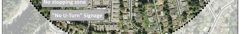
21 Improvement Type 1. Curb extensions 1a 1b District of North Vancouver / North Vancouver School District #44 Table 2.3: Improvement Options Braemar Elementary Location Mahon Avenue at Evergreen Place Delbrook Avenue at Evergreen Place 2. Sidewalks 2a Evergreen Place 3. Marked Crosswalks 3a 3b 3c Mahon Avenue at Evergreen Place Mahon Avenue at Evergreen Place Delbrooke Avenue at Saville Crescent 4. Signs 4a Evergreen Place 5. Valet Program 5a 6. Trails 6a 7. Traffic Restrictions 8. Programs / In-Class Initiatives 7a 7b 7c 9a Evergreen Place West Braemar Road/Calder Avenue trail Calder Place, north of Evergreen Place (cul-de-sac) Everglade Place Evergreen Place (south side) Description Reduce curb radius at existing sidewalk and provide curb extensions on northwest and southwest corner to reduce pedestrian crossing distance Provide curb extensions at existing sidewalk to reduce pedestrian crossing distance Provide sidewalk on north side of Evergreen Place, between Everglade Place and Mahon Avenue in conjunction with valet program (5a) to designated a preferred pick-up and drop-off area Provide new raised crosswalk on north leg of Mahon Avenue and Evergreen Place intersection to discourage vehicles entering cul-de-sac and improve pedestrian safety Crossing guards and pylons in morning and afternoon to discourage vehicles entering cul-de-sac and improve pedestrian safety Relocate crosswalk to south leg of intersection for better sightlines No U-turn Signs to discourage U-Turns on Evergreen lance Implement valet program, with drop-offs occurring on Evergreen Place and student volunteers escorting dropped off students to the school entrance. (Can acquire BCAA support for this initiative, as BCAA offers training to support valet program and traffic safety patrol programs) Complete paved trail, and cutback vegetation to improve visibility and accessibility Local traffic only 8:30am to 9:30am, 2:30pm to 3:30pm to improve pedestrian safety Local traffic only 8:30am to 9:30am, 2:30pm to 3:30pm to improve pedestrian safety No parking 8:30am to 9:30am, 2:30pm to 3:30pm to provide for a drop off & pick up zone - Participate in TransLink s TravelSmart program for elementary schools. - Pursue rideshare initiatives/education through online carpooling networks ( and information at - Issue announcements/reminders to parents on safety improvements and/or changes in traffic rules, as well as information on safe routes to school - Promote in-class education promoting walking, cycling and traffic safety including walking field trips, in conjunction with the RCMP and ICBC - Include information on the school website on safe routes to school / active transportation - Promote a Walking or Cycling School Bus Program - Engage in bike/walk to school events such as bike to school week, Winter Walk Day, IWalk with contests and prizes with related in-class activities - Consider a traffic safety patrol program 18


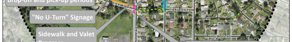
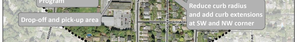
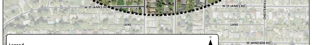
22 District of North Vancouver / North Vancouver School District #44 Figure 2.9: Preliminary Improvement Options Braemar Elementary 19

23 3.0 CLEVELAND ELEMENTARY District of North Vancouver / North Vancouver School District # Context Cleveland Elementary is located on Eldon Road, east of Capilano Road in the northern part of the Capilano neighbourhood. The school provides instruction to nearly 500 students from Kindergarten through Grade 7. Cleveland is a dual-track school that offers an English Program and French Immersion Programs from Kindergarten to Grade 7. The neighbourhood surrounding the school generally consists of low density, single-family residential housing, and is located near Eldon Park. The school s catchment area for the English language program is bounded by Capilano River to the west, Ridgewood Drive to the south, Mackay Creek to the east, and Handsworth Road to the north. 3.2 Demographics Cleveland Elementary had a student enrollment in the school year of 486 students. As shown in Table 3.1, the school has a very high proportion of students enrolled in French Immersion, with nearly two-thirds (63%) of the student population enrolled in the French Immersion program. Table 3.1: Student Enrollment by Program Program Number of Students Proportion of Students English % French Immersion % Total % Cleveland Elementary has a significant number of students who live beyond a reasonable walking distance to the school, as shown in Figure 3.1. As noted in Table 3.2, while approximately 17% and 40% of students live within a five and ten minute walking distance to school, respectively, approximately 60% of students live further than a ten minute walking distance from the school, with over a third (37%) of students living more than a twenty minute walk from the school (greater than 1,600 metres). 20


24 District of North Vancouver / North Vancouver School District #44 Figure 3.1: Cleveland Elementary Student Location Table 3.2: Student Enrollment by Distance from School Distance From School Proportion of Students < 400 metres 17% metres 24% metres 12% metres 10% >1600 metres 37% Total 100% 21


25 3.3 Travel Patterns District of North Vancouver / North Vancouver School District #44 The results of the on-line survey indicated that the vast majority of Cleveland Elementary students arrive at the school by walking or in a car driven by their parent or caregiver on both sunny and rainy days. As shown in Figure 3.2, travel patterns were relatively similar on dry and sunny days and rainy days. In fact, the proportion of trips made by walking did not change significantly on dry or sunny days (45% of trips) compared to rainy days (41%). 9% of students typically bicycle to work on sunny days, but no reported cycling trips were made on rainy days. No survey respondents indicated that they took transit, used a day care vehicle, or rode in vehicles with another parent or caregiver to get to school on either sunny or rainy days. Figure 3.2 Mode Share to Cleveland Elementary on Sunny and Rainy Days Sunny Days Rainy Days Car (driven with another family), 0% Day Care vehicle, 0% Car (driven with another family), 0% Day Care vehicle, 0% Car (driven by parent or caregiver), 45% Walk, 45% Car (driven by parent or caregiver), 59% Walk, 41% Transit, 0% Bicycle, 9% Transit, 0% Bicycle, 0% As noted above, a large proportion of Cleveland Elementary students are in the French Immersion program and, and over half of the students live beyond a ten minute walking distance to the school, which has significant implications on the travel patterns to and from Cleveland Elementary. As noted above, approximately 45% of students typically walk to school on dry or sunny days. However, this varies significantly among students in the English and French Immersion Programs, as approximately 79% of students in the English Program walk to school on dry or sunny days, compared to only 32% of French Immersion students. As shown in Figure 3.3, the overwhelming majority of students who live within approximately 400 metres (roughly a five minute walk) walk to school on both sunny and rainy days (92% and 88% of students, respectively). The number of students reporting that they walk to school declines significantly 22
26 District of North Vancouver / North Vancouver School District #44 beyond a five-minute walking distance. Approximately half of students who live between a five and twenty minute walking distance to school walk to school on sunny days, although this drops somewhat on rainy days. Figure 3.3: Walking Mode Share to School Based on Distance to School 100% 90% 80% 70% 60% 50% 40% 30% 20% 10% 0% 92% 88% <400 metres (less than five minute walk) 58% 58% metres (five to ten minute walk) 50% 50% 50% 25% 800-1,200 metres (ten to fifteen minute walk) 1,200-1,600 metres (fifteen to twenty minute walk) 3% 0% >1,600 metres (greater than twenty minute walk) Sunny Days Rainy Days 3.4 Transportation Initiatives Traffic safety initiatives at Cleveland Elementary include the placement of on-street pylons on Eldon Road in front of the school for the duration of the school day, and a parent and student crossing guard program in the morning and afternoon on Eldon Road. Until recently, the school had a kindergarten valet program due to the proximity of the classrooms to the parking lot, but this initiative was recently discontinued when kindergarten classes were relocated. The school participates and promotes Bike to School week, which has seen high participation rates, with the 2010/2011 school year seeing on average 250 participants biking to school daily. Cleveland Elementary also has a Walk to School program, which includes Walking Wednesdays where parents and children are encouraged to take active modes to school rather than drive on Wednesdays. The school has also participated International Walk to School month through promoting IWALK Day, and promotes awareness to parents through the school newsletter. The school newsletters also issue notices to parents about drop-off/pick-up zones and traffic regulations. 23
27 3.5 Existing Conditions District of North Vancouver / North Vancouver School District #44 This section describes existing transportation conditions in the area around Cleveland Elementary school. This includes a summary of existing access points, road network characteristics, pedestrian facilities, bicycle facilities, transit services and facilities, parking, drop-off and pick-up zones, and safety Access Points The main entrance to Cleveland Elementary is on Eldon Road, with the majority of drop-off and pick-ups occurring here during peak hours. Access to the school is also provided by trails connecting to the school from Mount Crown Road, Lewister Road, Loraine Avenue, and Kendal Place. These trails allow students and parents to walk and bicycle from the southern and eastern parts of the neighbourhood, and also allow parents driving to school to drop-off and pick-up their children at the trailheads Road Network Road Classifications As shown in Figure 3.4, the neighbourhood around Cleveland Elementary is typically characterized by local roads, with the exception of Eldon Road and Capilano Road. Capilano Road is classified as a major arterial road with a primary function to support traffic movement of all types of vehicles. Capilano Road has one travel lane in each direction, with parking generally permitted on both sides of the street. Eldon Road is classified as a collector road, with one travel lane in either direction and parking allowed on both sides, excluding the restricted school zones, as described in further detail below. Intersections The most notable intersection near the school is at Capilano Road and Eldon Road. This intersection has only a pedestrian activated signal to cross Capilano Road and traffic queues were observed here during peak hours as vehicles wait to turn left onto Capilano Road. Further congestion issues are augmented at this intersection by the queuing of southbound vehicles on Capilano Road waiting to turn left onto Eldon Road. Other notable intersections around the school include Eldon Road at Bracknell Place, and Capilano Road at Mount Crown Road. Further afield from the school, the Loraine Avenue intersections at Lewister Road and at Sunset Boulevard present safety challenges for those walking on these key routes to school. 24
28 District of North Vancouver / North Vancouver School District #44 Figure 3.4: Cleveland Elementary Road Network Classification 25
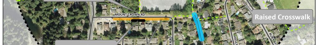
29 3.5.3 Pedestrian Facilities District of North Vancouver / North Vancouver School District #44 Sidewalks As shown in Figure 3.5, Eldon Road has sidewalks on both sides of the street between Capilano Road and Bracknell Crescent. East of Bracknell Crescent, the sidewalk only continues on the south side of the street. Bracknell Place contains a short segment of sidewalk on its west side, which stops before Bracknell Crescent. Similarly, Mount Crown Road contains a small segment of sidewalk on its south side, near the intersection with Capilano Road. Other than these facilities, pedestrians using Mount Crown Road, Bracknell Crescent, Lewister Road, and Loraine Avenue must walk in the roadway. Crosswalks The main marked crosswalk across Eldon Road is located near the school entrance, and is demarcated with traffic cones during school hours. Curb extensions were recently installed to shorten the distance crossed by pedestrians. This marked crosswalk is monitored by a volunteer parent and students during peak hours. There is also a marked crosswalk at the Eldon Road and Bracknell Place intersection which is not monitored by crossing guards, but is also demarcated with cones and pylons to increase the awareness of drivers. Marked crosswalks are also provided across Capilano Road at both Eldon Road and Mount Crown Road. Trails As shown in Figure 3.5, there are a number of trails that provided access to Cleveland Elementary from a number of different directions. From the south of the school property, there are two main trails. The trail from Mount Crown Road, through the wooded area on the west of the gravel field, provides access to the back and west side of the school. A trail leading from Loraine Avenue around the eastern edge of the school property provides access to the back of the school. The Kendal Place cul-de-sac also connects to this east trail. Additional trails facilitate access to the school from adjacent neighbourhoods, such as those from Sunset Boulevard to Eldon Road, and from Hillcrest Avenue to Loraine Avenue. 26

30 District of North Vancouver / North Vancouver School District #44 Figure 3.5: Cleveland Elementary Existing Pedestrian Facilities 27
31 District of North Vancouver / North Vancouver School District # Bicycle Facilities Bicycle Routes There are no designated bicycle routes in the area around Cleveland Elementary, although the District s draft 2011 Bicycle Master Plan identifies a planned on-street bicycle route on Capilano Road in the future. Trails Most of the trails on the school grounds contain staircases and thus deter use by cyclists. To facilitate use of the trail on the western edge of the gravel field, the school has one bicycle rack placed at the foot of the staircase, which allows students to lock up their bicycles before ascending the trail. Bicycle Parking There are currently two bicycle racks on the school property The first near the main entrance on Eldon Road, and the second located on the back gravel field. Both of the racks were observed to be moderately used on sunny days, with approximately 7 to 10 bicycles in each rack Transit Services and Facilities Capilano Road is the nearest transit corridor, with several north-south bus routes, including: #236 Lonsdale Quay, Grouse Mountain operates every 15 minutes; #246 Downtown, Lonsdale Quay, Highlands operates every 15 minutes during peak hours, and every 30 minutes during off-peak hours; #247 Downtown, Upper Capilano, Grouse Mountain operates every 30 minutes between 8:00am to 9:00 am and 4:00pm to 6:00pm; #232 Grouse Mountain, Phibbs Exchange operates every 30 minutes. The nearest bus stop to Cleveland Elementary is at the Eldon Road and Capilano Road intersection Parking Off-Street Parking Staff parking at Cleveland Elementary is divided into three parking lots, with a total of 32 parking stalls. The lots were observed to have a vacancy of approximately 1 to 3 spots per lot. The number of parking stalls is generally sufficient to accommodate staff demand, with less than 25 full-time equivalent (FTE) teachers and administrators on staff. On-Street Parking Parents are restricted from using the staff parking lot for drop-off and pick-up activity. As shown in Figure 3.6, there are several areas on Eldon Road where parking is restricted during school hours. As a result, the majority of parent parking occurs in the designated drop-off/pick-up zones on Eldon Road, and on Bracknell Crescent and Ruby Avenue where no parking restrictions apply. Peak hour parking was 28
32 District of North Vancouver / North Vancouver School District #44 observed to extend along Ruby Avenue as far as Hillcrest Avenue. Further, considerable congestion can occur at the intersections of Bracknell Place and Eldon Road, as many parents use this road to park, and then to turn around Drop-off Zones Eldon Road has several designated drop-off/pick-up zones on both sides of the street. The zones are delineated by pylons during school hours, and are located intermittently between Bracknell Place and Bracknell Crescent. These drop-off zones prohibit parking during 8:00am to 4:00pm on school days, but parents were observed to use these zones to park and wait for their children at day s end Safety ICBC collects and maintains statistics for all reported collisions in British Columbia. The collision data classifies reported collisions based on the type of reported collision as follows: fatality, injury, material damage (above $1,000), and material damage (under $1,000), and also includes reported collisions involving pedestrians or cyclists. ICBC collision data was reviewed for all roads within approximately 400 metres of Cleveland Elementary for the past five years (2006 to 2010) to identify overall collision frequencies around the school. Overall it was found that collisions around schools are not very common, and those that do occur are generally relatively minor and do not usually involve pedestrians or cyclists. The highest number of reported collisions was found along Capilano Road at the Eldon Road intersection, followed by Capilano Road at Mount Crown Road, Capilano Road north of Eldon Road, and Eldon Road adjacent to Cleveland Elementary between Bracknell Place and Bracknell Crescent. However, it should be noted that the majority of reported collisions around the school (84%) only involved material damage. 16% of reported collisions did result in an injury, all of which occurred along Capilano Road. No reported collisions were noted to have involved pedestrians, and one collision over this period along Capilano Road between Edgemont Boulevard and Mount Crown Road was noted to have involved a cyclist. 29
33 District of North Vancouver / North Vancouver School District #44 Figure 3.6: Cleveland Elementary Parking and Stopping Restrictions 30
34 3.6 Issues District of North Vancouver / North Vancouver School District #44 This section describes transportation and safety issues that have been identified to date based on the on-line survey responses, field visits, and existing conditions summary in the previous section. The on-line survey asked respondents to identify which issues present safety concerns getting their children to and from school. As shown in Figure 3.7, the primary safety concerns identified by survey respondents were related to traffic, safety, and crosswalks. Figure 3.7: Cleveland Elementary Reported Safety Concerns Traffic 42 Safety 29 Crosswalks 25 Issue Walking to School Parking Pick-Up/Drop-Off Cycling to School Number of Responses The on-line survey also asked respondents to identify the key transportation issues affecting the decision to allow their children to walk or bicycle to or from school. As noted in Figure 3.8, the most significant issue identified by survey respondents for Cleveland Elementary was the safety of intersections and crossings, followed by children s before or after school activities, traffic volumes, and traffic speeds. Other notable issues included affecting this decision included the time and distance to school and the presence of sidewalks of trails. 31
35 District of North Vancouver / North Vancouver School District #44 Figure 3.8: Cleveland Elementary Transportation Issues Issue Safety of Intersections and Crossings Child's Before or After School Amount of Traffic Along Route Speed of Traffic Along Route Time Sidewalks or Trails Distance Adults to Walk or Bike With Crossing Guards Weather or Climate Violence or Crime Convenience of Driving Number of Responses Specific transportation and safety issues that have been identified to date around Cleveland Elementary include: Speeding is perceived as an issue on several roads near the school, including Capilano Road, Eldon Road, Ruby Avenue, Sunset Boulevard, and Ridgewood Drive; Missing sidewalks on several streets, including the west side of Capilano Road, east side of Ruby Road, the north side of Mount Crown Road, and on Loraine Avenue; Vegetation overgrowth on sidewalks including those along Eldon Road; Intersection safety is perceived to be an issue at several locations, including the Capilano Road intersections at Mount Crown Road and Eldon Road; Ridgewood Avenue at Paisley Road/Sunset Boulevard; Sunset Boulevard intersections at Edgemont Boulevard and Virginia Crescent, the Loraine Avenue and Lewister Road intersection which lacks both a stop sign and sidewalks; and the Eldon Road and Bracknell Road intersection which lacks a marked crosswalk. Lack of parking close to the school entrance; Traffic volumes during drop-off and pick-up periods, particularly along Eldon Road leads to difficulty crossing from stairs, as well as along Capilano Road; Intermittent speed restriction signage particularly along Ruby Avenue near Eldon Park, where the signage is neither prominent nor frequent; Traffic congestion at the Capilano Road and Eldon Road intersection with vehicles queuing both on Eldon Road westbound and Capilano Road southbound waiting to turn left; and 32
36 District of North Vancouver / North Vancouver School District #44 Driver behavior, including vehicles not following traffic regulations, such as parking in noparking areas, not stopping for pedestrians in crosswalks, u-turns, blocking of and turning around in driveways, and stopping in the street. 3.7 Improvement Options The existing conditions and issues at Cleveland Elementary School were assessed, and improvements were identified to enhance the safety of walking and cycle routes to the school grounds. Table 3.3 below describes the recommended improvement options proposed to the Cleveland PAC, DNV, and NVSD for potential inclusion in the final school safety implementation strategy (discussed further in Section 5.0). Please note that recommendations are aligned with the 2007 Upper Capilano Road Crosswalk Location Priority and Safety Review study by ICBC. Figure 3.9 shows the location of these improvement options. 33
37 Improvement Type 1. Curb extensions 2. Sidewalks 3. Marked Crosswalks 4. Signs 1a 1b 2a 2b 3a 3b 3c District of North Vancouver / North Vancouver School District #44 Table 3.3: Improvement Options Cleveland Elementary Location Eldon Road at Bracknell Place Eldon Road at Capilano Rd. Bracknell Place Mount Crown Road Eldon Road at Bracknell Place Eldon Road (in front of school entrance) Ruby Avenue at Hillcrest Avenue Description Provide curb extensions on east side of intersection at existing marked crosswalk to reduce pedestrian crossing distance Provide curb extensions on south side of intersection at existing marked crosswalk to reduce pedestrian crossing distance Construct sidewalk on east side of Bracknell Place to improve pedestrian safety Extend existing sidewalk on south side of road to intersection with Lewister Rd. to improve pedestrian safety Raise existing marked crosswalk to reduce traffic speeds and improve pedestrian safety Raise existing marked crosswalk to reduce traffic speeds and improve pedestrian safety Raise existing marked crosswalk to reduce traffic speeds and improve pedestrian safety 3d Mount Crown Road Provide no-stopping zone at trail entrance to ensure visibility 4a Mount Crown Road Provide No U-turn signs to discourage u-turn movements 4b Mount Crown Road Provide signs at trailhead to improve visibility and awareness of trail 4c Ruby Avenue, Eldon Road Provide additional 30 km/hr signs to reduce vehicle speeds 5. Intersection Eldon Road at Capilano Consider intersection improvements as part of the Capilano Road 5a Improvemens Road Road Safety Plan 6a Sunset Blvd at Pelly Implement traffic calming treatments (i.e. curb extensions, traffic Road/Virginia circle) to improve safety 6. Outlying Sunset Blvd at Edgemont 6b Intersections Blvd Conduct separate study on intersection safety/treatments 6c Loraine Avenue at Lewister Road Install a stop sign to improve intersection safety 7. Bike racks 7a School grounds Provide more bicycle racks in the upper and lower grounds 8. Traffic No stopping 8:30a to 9:30am and 2:30 to 3:30 to prevent pick-ups 8a Lorraine Avenue (cul-de-sac) restrictions and drop-offs in the cul-de-sac - Participate in TransLink s TravelSmart program for elementary schools - Pursue rideshare initiatives/education through online carpooling networks ( and information at - Issue announcements/reminders to parents on safety improvements and/or changes in traffic rules, as well as information on safe routes to school 8. Program / In-class Initiatives 8a - Promote in-class education promoting walking, cycling and traffic safety including walking field trips, in conjunction with the RCMP and ICBC - Include information on the school website on safe routes to school / active transportation - Consider promoting a Park and Walk or Walking School Bus from Eldon Park parking Lot to the school entrance - Promote (or continue to promote) bike/walk to school events such as bike to school week, Winter Walk Day, IWalk with contests and prizes with related in-class activities - Consider a traffic safety patrol program, can acquire safety training from BCAA 34


38 District of North Vancouver / North Vancouver School District #44 Figure 3.9: Improvement Options Cleveland Elementary 35

39 4.0 ROSS ROAD ELEMENTARY District of North Vancouver / North Vancouver School District # Context Ross Road Elementary is located on Bushnell Place, south of Ross Road in Lynn Valley. The school provides instruction to over 500 students from Kindergarten through Grade 7. Ross Road is a dualtrack school that offers an English Program and French Immersion Program from Kindergarten to Grade 7. The surrounding neighbourhood is predominantly a low to mediumdensity residential neighbourhood, and enjoys a close proximity to the services and amenities of the Lynn Valley Town Centre. The school s catchment area for the English language program is bounded by Mountain Highway to the west, Lynn Creek to the east, East 27 th Street and Hastings Creek to the south, and Ross Road and Westover Road to the north. 4.2 Demographics Ross Road Elementary had a student enrollment in the school year of 525 students. As shown in Table 4.1, the school has the highest proportion of students enrolled in French Immersion of the three schools in this study, with nearly two-thirds (64%) of the student population enrolled in the French Immersion program. Table 4.1: Student Enrollment by Program Program Number of Students Proportion of Students English % French Immersion % Total % Ross Road Elementary has a significant number of students who live beyond a reasonable walking distance to the school, as shown in Figure 4.1. However, the majority (52%) of Ross Road students actually live within 800 metres (approximately ten minute walking distance) from the school, as noted in Table 4.2. In contrast, less than half (48%) of students live further than a ten minute walking distance (800 metres), while only 18% of students live further than a twenty minute walking distance (1,600 36


40 District of North Vancouver / North Vancouver School District #44 metres). As will be discussed further below, the distances that students travel to school has significant implications for travel patterns to Ross Road Elementary. Figure 4.1: Ross Road Elementary Student Location Table 4.2: Student Enrollment by Distance from School Distance From School Proportion of Students < 400 metres 20% metres 32% metres 17% metres 13% >1600 metres 18% Total 100% 37
 and on rainy days (51%). In fact, as shown in Figure 4.2, the proportion of trips to school by walking is significant, even on rainy days.")

41 4.3 Travel Patterns District of North Vancouver / North Vancouver School District #44 The results of the on-line survey indicated that the majority of students walk to school on both dry or sunny days (54%) and on rainy days (51%). In fact, as shown in Figure 4.2, the proportion of trips to school by walking is significant, even on rainy days. Ross Road Elementary also has a significant proportion of students (12%) who bicycle to school on sunny days. Of particular note is that there is a relatively low proportion of students who are driven to school by their parent or caregiver. In addition to a higher proportion of walking and cycling trips to Ross Road is partially accounted for by respondents indicating they use more varied transportation option, most notably vehicles driving with another family and day care vehicles. Figure 4.2: Mode Share to Ross Road Elementary on Sunny and Rainy Days Sunny Days Rainy Days Car (driven with another family), 8% Day Care vehicle, 7% Car (driven with another family), 11% Day Care vehicle, 8% Car (driven by parent or caregiver), 19% Walk, 54% Car (driven by parent or caregiver), 30% Walk, 51% Transit, 0% Bicycle, 12% Transit, 0% Bicycle, 0% As shown in Figure 4.3, the overwhelming majority of students who live within approximately 800 metres (roughly a ten minute walk) walk to school on both sunny and rainy days. This is particularly significant due to the fact that the majority of students live within 800 metres of the school. The percentage of students who walk to school decreases significantly beyond a ten minute walking distance, particularly on rainy days. 38
42 District of North Vancouver / North Vancouver School District #44 Figure 4.3: Walking Mode Share to School Based on Distance to School 100% 90% 80% 70% 60% 50% 40% 89% 84% 100% 100% 30% 50% 20% 33% 10% 20% 20% 6% 6% 0% <400 metres (less than five minute walk) metres (five to ten minute walk) 800-1,200 metres (ten to fifteen minute walk) 1,200-1,600 metres (fifteen to twenty minute walk) >1,600 metres (greater than twenty minute walk) Sunny Days Rainy Days 4.4 Transportation Initiatives Ross Road Elementary has already taken steps to promote active transportation and manage traffic movements and improve safety conditions at the school. The school promotes Bike to School week through providing incentives (i.e. class pizza rewards) and getting students to make awareness posters. The District implemented a one-way traffic loop that is in effect during peak hours in order to streamline traffic movements. Ross Road school newsletters often promote awareness about the one-way traffic loop, designated pick-up/drop-off locations, safety awareness, and reminders about no idling and blocking driveways. The school has a valet program to ensure smoother and safer traffic movements, where students are dropped off near the school entrance and then escorted into the school grounds by student volunteers. Parent volunteers also help to direct traffic and ensure safety and efficiency during the morning peak period. 4.5 Existing Conditions This section describes existing transportation conditions in the area around Ross Road Elementary school. This includes a summary of existing access points, road network characteristics, pedestrian facilities, bicycle facilities, transit services and facilities, parking, drop-off and pick-up zones, and safety. 39
43 4.5.1 Access Points District of North Vancouver / North Vancouver School District #44 The main entrance to Ross Road Elementary is located on Bushnell Place. Students can also access the school through the Allan Road cul-de-sac, which backs onto the school property, as well as through a trail that connects to East 27 th Street to the south of the school Road Network Road Classifications As shown in Figure 4.4, there are a number of collector and arterial roads near Ross Road Elementary. Lynn Valley Road and Mountain Highway are classified as major arterial roads, with a primary function to support traffic movement of all types of vehicles. Ross Road is currently classified as a minor arterial road, which also has a primary function to support traffic movement on roads with 3,000 10,000 vehicles per day. However, as part of the District s Transportation Plan, Ross Road is being considered to be reclassified as a collector road to better reflect its existing traffic volumes of approximately 3,700 vehicles per day and because a previously planned extension of Ross Road is not longer being considered. Other roads currently classified as collector roads near the school include Bushnell Place, Hoskins Road, Allan Road north of Ross Road, East 27 th Street west of Viewlynn Drive, and Viewlynn Drive. All remaining roads near the school are classified as local roads. Intersections Key intersections in close proximity to the school include Bushnell Place at Kilkenny Road, Bushnell Place at Ross Road, and Kilkenny Road at Hoskins Road Pedestrian Facilities Sidewalks The majority of the streets in the area around Ross Road Elementary have a sidewalk on at least one side of the street. This is largely a reflection of the number of collector and arterial roads in the area around the school. Hoskins Road south of Ross Road has sidewalks on both sides of the street. Ross Road, Bushnell Place, Kilkenny Road, Allan Road north of Ross Road, and Hoskins Road north of Ross Road all have sidewalks on one side of the street. Trails The forested area to the south of the school property contains a trail network that facilitates the movement of students from the southern neighbourhoods. There is a short trail connection from East 27 th Street, and also a longer trail that runs along Hastings Creek, with connections to some of the adjacent residential areas. The trail has steep topography in areas, is well-maintained, and is unsigned at the trailheads. The trail from East 27 th Street is well used by students and parents walking in and out with their children. 40
44 District of North Vancouver / North Vancouver School District #44 Figure 4.4: Ross Road Elementary Road Network Classification 41
45 District of North Vancouver / North Vancouver School District #44 Figure 4.5: Ross Road Elementary Existing Pedestrian Facilities 42
46 District of North Vancouver / North Vancouver School District #44 Crosswalks Marked crosswalks are provided at several locations, including the south side of the Bushnell Place and Kilkenny Road intersection, west side of the Allan Road and Ross Road intersection, and the south side of the Kilkenny Road and Hoskins Road intersection Bicycle Facilities Bicycle Routes There District s 2011 draft Bicycle Master Plan identifies bicycle routes on East 27 th Street, Viewlynn Drive, and Lynn Valley Road. Trails in Hastings Creek are not amenable to cyclists due to the steep topography and presence of stairs and steep embankments. Bicycle Racks There are four bicycle racks at Ross Road Elementary. One rack is located in the front of the building near the playground, which is used mainly by the students in the primary grades. This bicycle rack is considerably newer than the other racks, and as such is in very good condition. Field observations were made in early June during both the morning and afternoon peak period, and the front rack was observed to be in high use (over 15 bicycles per day) on sunny days, with bicycles also locked to a nearby tree because of lack of space. The other three bicycle racks are located in the rear of the building, and are primarily used by older students. These racks were also observed to be very well used, with approximately 20 to 30 bicycles per day. In addition to the formal bicycle parking, the chain fence that separates the rear play area from the gravel field as an informal bicycle parking was also observed to be a popular parking spot for bicycles. In total, approximately 40 to 50 bicycles were observed to be parked on the school grounds during fair weather days in June. While this may have been due to sunny weather, it was also noted that the school had promoted Bike to School Week the previous week, with daily prizes for the class with the most participants. This may have effectively encouraged more students to use bicycles even after Bike to School week finished Transit Facilities Ross Road and Hoskins Road are the nearest transit corridors to Ross Road Elementary, served by the 229 route. Descriptions of this route and other nearby transit routes are as follows: #229 West Lynn, Phibbs Exchange, Lonsdale Quay This bus operates on Hoskins Road, with the closest bus stop at the intersection with Kilkenny Road. The frequency of Route #229 is every 30 minutes, except during the evening peak hour period when the bus operates every 15 minutes. 43
47 District of North Vancouver / North Vancouver School District #44 #228 Lonsdale Quay Operates every 15 to 30 minutes during peak hours, and every 30 minutes during non-peak hours. Provides service between Lonsdale Quay and Upper Lynn Valley, with service on Lynn Valley Road. #209/210 Vancouver Offers peak hour service every 10 to 15 minutes, with non-peak hour service every 30 minutes. Provides service between Upper Lynn Valley and downtown Vancouver, with service on Mountain Highway. #255 Capilano University/Dundarave Provides service via Mountain Highway, Lynn Valley Road and Marine Drive between Dundarave in West Vancouver and Capilano University in eastern North Vancouver. Morning peak hour service is provided every 30 minutes and evening peak hour service is every 15 minutes. Non-peak hour service is offered every 30 minutes Parking Off-Street Parking Ross Road Elementary has two lots available for staff parking only with a total of 28 parking spaces. The primary lot, which has an entrance off of the Bushnell Place cul-de-sac, has 22 parking stalls, while the secondary lot has 6 stalls. There is no preferential parking, except one stall for disabled parking in the primary lot. The demand for the parking spaces is primarily from the school staff, of which Ross Road has approximately 26 full-time equivalent (FTE) teachers and administrators, approximately 12 office and support staff members, and additional student services members on staff. Both of the parking lots were observed to be at or near capacity on multiple occasions, suggesting the current parking lot supply may not sufficiently meet staff parking demands. On-Street Parking As shown in Figure 4.6, on-street parking is not permitted any time on the west side of Allan Road south of Ross Road. Parking is not permitted during school hours (8:00am to 4:00pm) on the south side of Kilkenny Road east of Bushnell Place, and on the west side of Bushnell Place north of Kilkenny Road. In addition, there is no stopping or parking permitted on the east side of Bushnell Place, in order to enforce the one-way traffic loop that is in place during peak hours. Parking is permitted on both sides of all other streets. 44


48 District of North Vancouver / North Vancouver School District #44 Figure 4.6: Ross Road Elementary Parking and Stopping Restrictions 45
49 4.5.7 Drop-off Zones District of North Vancouver / North Vancouver School District #44 In the morning drop-off period, Ross Road Elementary has implemented a successful valet parking program on the west side of Bushnell Place, which allows parents to drive their children to the front of the school where a student volunteer will escort those students dropped off to the school entrance. This avoids parents having to park and walk in with their children, and allows for more efficient traffic movements on Bushnell Place and Kilkenny Road. In both the morning and afternoon, many parents use Kilkenny Road and Ross Road for drop-offs and pick-ups. In the afternoon, there is much more parking activity occurring on Kilkenny Road, with cars lining up on along almost the entire length of both sides of the road. As well, parents were observed to park on Allan Road, which causes considerable congestion in the narrow roadway Safety ICBC collects and maintains statistics for all reported collisions in British Columbia. The collision data classifies reported collisions based on the type of reported collision as follows: fatality, injury, material damage (above $1,000), and material damage (under $1,000), and also includes reported collisions involving pedestrians or cyclists. ICBC collision data was reviewed for all roads within approximately 400 metres of Ross Road Elementary for the past five years (2006 to 2010) to identify overall collision frequencies around the school. Overall it was found that collisions around schools are not very common, and those that do occur are generally relatively minor and do not usually involve pedestrians or cyclists. The highest number of reported collisions was found at the Ross Road and Hoskins Road intersection, followed by Ross Road between Allan Road and Bushnell Place, and Bushnell Place south of Kilkenny Road. It should be noted that the majority of reported collisions around the school (93%) only involved material damage. 7% of the reported collisions did result in an injury, most of which occurred along Ross Road and at the Ross Road and Hoskins Road intersection. No reported collisions were noted to have involved cyclists, and one collision over this period was noted to have involved a pedestrian along Ross Road. 4.6 Issues This section describes transportation and safety issues that have been identified to date at Ross Road Elementary based on the on-line survey responses, field visits, and existing conditions summary in the previous section. The on-line survey asked respondents to identify which issues present safety concerns getting their children to and from school. As shown in Figure 4.7, the primary safety concerns identified by survey respondents were related to traffic, crosswalks, and parking. 46
50 District of North Vancouver / North Vancouver School District #44 Figure 4.7: Ross Road Elementary Reported Safety Concerns As noted in previous sections, the on-line survey also asked respondents to identify the key transportation issues affecting the decision to allow their children to walk or bicycle to or from school. As noted in Figure 4.8, the most significant issue identified by survey respondents for Ross Road Elementary was the safety of intersections and crossings, followed by traffic volumes, distance to school, and traffic speeds. Figure 4.8: Ross Road Elementary Transportation Issues Safety of Intersections and Crossings Amount of Traffic Along Route Distance Speed of Traffic Along Route Sidewalks or Trails Time Adults to Walk or Bike With Child's Before or After School Activities Weather or Climate Crossing Guards Violence or Crime Convenience of Driving Issue Number of Responses 47
51 District of North Vancouver / North Vancouver School District #44 Specific transportation and safety issues that have been identified to date around Ross Road Elementary include: Speeding is perceived as an issue on Ross Road, Lynn Valley Road, and Mountain Highway; Missing sidewalks on several streets, including the north side of Ross Road, north side of Kilkenny Road, east side of Bushnell Road, and both sides of East 27 th Street; Intersection safety on Ross Road at Hoskins Road; Traffic volumes during drop-off and pick-up periods, particularly along Ross Road; Pick-up and drop-off in the Allan Road cul-de-sac presents issues regarding safety, congestion, and blocked driveways due to the narrow width of Allan Road Driver behavior, including vehicles not following traffic regulations, such as parking in noparking areas, double parking, and blocking of driveways. 4.7 Improvement Options The existing conditions and issues at Ross Road Elementary School were assessed, and opportunities were identified to introduce improvements to enhance safety of walking and cycle routes to the school grounds. Table 4.3 below describes the recommended improvement options proposed to the Ross Road PAC, DNV, and NVSD for potential inclusion in the final school safety implementation strategy (discussed further in Section 5.0). Figure 4.9 shows the location of these improvement options. 48
52 Improvement Type 1. Curb Extensions 2. Sidewalks 3. Marked Crosswalks 1a 1b 2a 2b 2c 2d 3a 3b District of North Vancouver / North Vancouver School District #44 Table 4.3: Improvement Options Ross Road Elementary Location Description Ross Road at Allan Road Kilkenny Road at Hoskins Rd. Ross Road Bushnell Place Kilkenny Road East 27 th Street Ross Road at Bushnell Place Bushnell Place at Kilkenny Road Upgrade temporary curb extension to permanent curb extension on northwest corner of intersection to reduce pedestrian crossing distance and improve pedestrian visibility Provide curb extensions on south side of intersection at marked crosswalk to reduce pedestrian crossing distance Construct sidewalk on north side between Allan Road and Hoskins Road to improve pedestrian safety and accessibility Construct sidewalk on east side to improve pedestrian safety and accessibility Construct sidewalk on north side to improve pedestrian safety and accessibility Extend existing sidewalk on south side of East 27 th street to connect sidewalk to trail Provide new marked crosswalk, only in conjunction with sidewalk improvements on Bushnell Place/Ross Road (2a/2b) Upgrade existing marked crosswalk to raised crosswalk and/or introduce pylons at marked crosswalk to discourage vehicles from entering cul-de-sac and improve pedestrian safety 3c East 27 th Street Implelement no stopping zone to trail head to improve visibility 4a Bushnell Place Simplify amount of signs 4b Kilkenny Road at Hoskins Rd Provide clearer signs (i.e. no left-turn during peak hours ) 4. Signage 4c Entrance to East 27 th trail Provide wayfinding signs at trailheads to improve visibility 4d Kilkenny Road Provide No idling signs Repaint yellow curb to make no-parking restrictions more 5. Painted Curbs 5a Allan Road cul-de-sac visible Local traffic only during peak hours to restrict vehicles in culde-sac and improve pedestrian safety 6a Allan Road (cul-de-sac) 6. Traffic Restrictions Bushnell Place (cul-de-sac, Local traffic only during peak hours to restrict vehicles in culde-sac and improve pedestrian safety 6b south of Kilkenny Road) Crosswalk at Bushnell 7. Crossing Guard 7a Designated crossing guard to school entrance Place/Kilkenny Road 8. Bicycle Additional racks near Allan Road entrance, replace existing 8a School grounds Infrastructure racks at rear of school (south grounds) - Participate in TransLink s TravelSmart program for elementary schools - Pursue rideshare initiatives/education through online carpooling networks ( and information at - Issue announcements/reminders to parents on safety improvements and/or changes in traffic rules, as well as information on safe routes to school - Include information on the school website on safe routes to school / active transportation 9. Programs/In- 9a - Promote in-class education promoting walking, cycling and traffic safety including walking Class Initiatives field trips, in conjunction with the RCMP and ICBC - Consider promoting a Walking (or Cycling) School Bus Program - Promote (continue to promote) in bike/walk to school events such as bike to school week, Winter Walk Day, IWalk with contests and prizes with related inclass activities - Consider a traffic safety patrol program, potential for BCAA to support with safety training 49


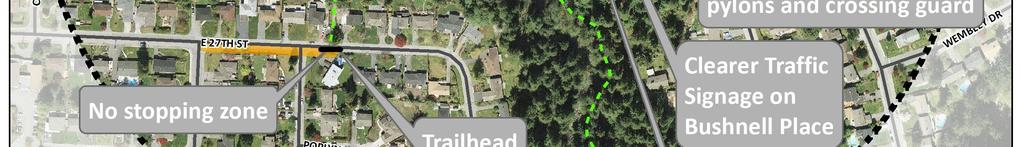
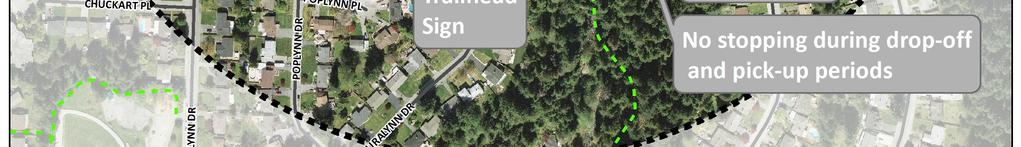
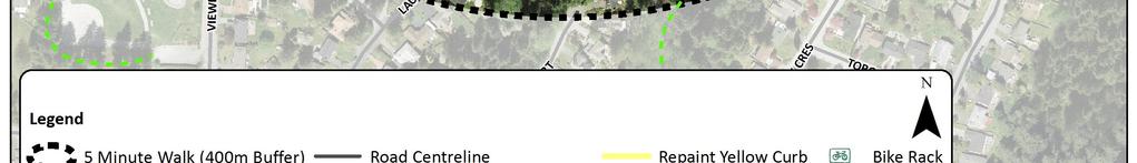
53 District of North Vancouver / North Vancouver School District #44 Figure 4.9: Improvement Options Ross Road Elementary 50
54 5.0 IMPLEMENTATION District of North Vancouver / North Vancouver School District # Priorities The recommended implementation strategy for Braemar Elementary, Cleveland Elementary and Ross Road Elementary is organized into the time frame of short-term and medium-long term. Short-term implementation strategies for each school are described in Tables 5.1, 5.3 and 5.5, and medium-long term strategies are outlined in Table 5.2, 5.4 and 5.6. Priorities were identified by the DNV and School District staff in conjunction with PAC representatives at each school. Short-term priorities were identified as the most pressing and effective improvements that will significantly improve conditions and community livability in the near future. Short-term implementation of engineering infrastructure generally includes high priority sidewalk construction, installation of curb extensions, installation of bicycle racks, and/or the implementation of local traffic restrictions. Several programmatic initiatives are also included in the short-term strategies, such as a valet program, walking school bus or park and walk programs, and participation in TransLink s TravelSmart program many of which can be undertaken by the school administration and/or School District. Further, short-term recommendations include incorporating in-class activities, such as active field trips or activities from Canadian safe routes to school organizations, in order to educate students on safety and active transportation. Enforcement, an activity often carried out by District bylaw officers, is also included in the short-term strategy, as it is necessary to ensure compliance to new parking and traffic restrictions. Medium and long-term priorities are targeted more specifically on infrastructure improvements. These improvements are which are not perceived to be critical immediately, but would further enhance and improve the environment for walking and cycling of routes after short-term priorities are implemented. Programmatic recommendations, such as in-class education opportunities, promotion of bike/walk to school initiatives, and school announcements to parents on traffic rules and safe routes are intended to carry on from the short-term into the medium and long-term time frame in order to establish a continued focus on healthy and safe travel behaviors. Random enforcement by the District s bylaw officers is also recommended on an on-going basis into the medium and long-term. 51
55 District of North Vancouver / North Vancouver School District #44 Engineering Education Encouragement Enforcement Evaluation Table 5.1: Short-Term Improvements Braemar Elementary Recommended Improvements Responsibility DNV NVSD School Other Evergreen Place, between Everglade Place and Mahon Avenue: Construct sidewalk on the north side (65m) Engage in the TravelSmart program (TransLink) for elementary schools Pursue opportunities for in-class education such as active field trips, and Active and Safe Routes elementary classroom activities Issue announcements/reminders to parents on traffic rules and/or safety improvements Evergreen Place: Potential valet program, with drop-offs occurring and student volunteers escorting dropped-off students to the school entrance Promote a Walking (or Cycling) School Bus program Promote events (and/or continue to promote) such as bike/walk to school week, Winter Walk day, IWalk club, with contests and class prize incentives Calder Place cul-de-sac: Implement traffic restrictions - Local Traffic Only 8:30am to 9:30 am and 2:30pm to 3:30pm (2 signs) Consider a traffic safety patrol program Bylaw officer enforcement upon changes to parking / traffic regulations Evaluate if safety improvements are achieving goals and if adjustments are required Table 5.2: Medium and Long-Term Improvements Braemar Elementary Recommended Improvements Responsibility DNV NVSD School Other Mahon Avenue at Evergreen Place:Curb extensions on northwest and southwest corner Mahon Avenue at Evergreen Place: Raise crosswalk at existing crosswalk on north leg Delbrook Avenue at Evergreen Place: Curb extensions at existing marked crosswalk Continue in-class safe routes/active transportation learning activities Yearly promotion of walk/cycle to school events West Braemar Road/Calder Avenue trail: Complete paved trail and trim vegetation Crossing guard (in absence of valet program) and pylons during the school day Evergreen Place: Install No U-Turn signs in conjunction with bylaw enforcement (2 signs) Evergreen Place (south side): Implement No Parking restrictions 8:30am to 9:30 am, 2:30 pm to 3:30 pm (4 signs) Everglade Place: Implement traffic restrictions Local Traffic Only 8:30 am to 9:30 am, 2:30 pm to 3:30 pm (2 signs) Random enforcement checks on a on-going basis by bylaw offices Evaluate if safety improvements are achieving goals and if adjustments are required 52
56 District of North Vancouver / North Vancouver School District #44 Engineering Education Encouragement Enforcement Evaluation Table 5.3: Short-Term Improvements Cleveland Elementary Recommended Improvements Primary Responsibility DNV NVSD School Other Eldon Road at Bracknell Place: Raise existing crosswalk Eldon Road (in front of school entrance): Raise existing crosswalk Ruby Avenue at Hillcrest Avenue: Raise existing crosswalk Install a stop sign at Loraine Avenue and Lewister Road (1 sign) Engage in the TravelSmart program (TransLink) for elementary schools Pursue opportunities for in-class education such as active field trips, Active and Safe routes to school elementary classroom activities Issue announcements/reminders to parents on traffic rules and/or safety improvements Promote (and/or continue to promote) events such as bike/walk to school week, Winter Walk day, IWalk club, with contests and class prize incentives Install more bicycle racks on the school grounds Consider a park and walk or Walking School Bus program from the Eldon Park parking lot to the entrance of Cleveland Elementary entrance More frequent/prominent 30 km/hr signs around Eldon Park (Ruby Ave) Consider a traffic safety patrol program Bylaw officer enforcement upon changes to parking / traffic regulations Evaluate if safety improvements are achieving goals and if adjustments are required Table 5.4: Medium and Long-Term Improvements Cleveland Elementary Recommended Improvements Eldon Road at Capilano Road: Curb extensions on south side of intersection (existing marked crosswalk) Responsibility DNV NVSD School Other Eldon Road at Bracknell Place: Curb extensions on east side of intersection at existing marked crosswalk Bracknell Place: Construct sidewalk on the east side (60m) Mount Crown Road:Construct sidewalk on south side of road to Lewister Road (150m) Mount Crown Road: Consider no stopping zone at trail entrance At Pelly Road / Virginia: Implement traffic calming treatments At Edgemont Boulevard: Conduct separate study on intersection safety/treatments Continue in-class safe routes/active transportation learning activities Yearly promotion of walk/cycle to school events Mount Crown Road: Install No U-Turn signs at intersection with Lewister Road (2 signs) Random enforcement checks on an ongoing basis for traffic/parking violations Mount Crown Road: Install wayfinding sign at trailhead to school (1 sign) Evaluate if safety improvements are achieving goals and if adjustments are required 53
57 District of North Vancouver / North Vancouver School District #44 Engineering Education Encouragement Enforcement Evaluation Table 5.5: Short-Term Improvements Ross Road Elementary Recommended Improvements Primary Responsibility DNV NVSD School Other Ross Road at Allan Road: Upgrade temporary curb extension to permanent curb extension on the northwest corner of intersection; at the existing sidewalk Engage in the TravelSmart program (TransLink) for elementary schools Pursue opportunities for in-class education such as active field trips, Active and Safe routes to school elementary classroom activities Issue announcements/reminders to parents on traffic rules and/or safety improvements Promote (and/or continue to promote) events such as bike/walk to school week, Winter Walk day, IWalk club, with contests and class prize incentives School Grounds: Install additional bicycle racks near Allan Road entrance, and replace existing racks at the rear of school (south grounds) Promote a Walking School Bus program Allan Road (cul-de-sac): Implement traffic restrictions - Local Traffic Only during 8:30am to 9:30 am and 2:30pm to 3:30pm (2 signs) Consider a traffic safety patrol program Simplify signs in drop-off and pick-up area (8 signs) Bylaw officer enforcement upon changes to parking / traffic regulations Evaluate if safety improvements are achieving goals and if adjustments are required Table 5.6: Medium and Long-Term Improvements Ross Road Elementary Recommended Improvements Responsibility DNV NVSD School Other Ross Road: Construct sidewalk between Allan Road and Hoskins Road (360m) Ross Road at Bushnell Place: New marked crosswalk in conjunction with sidewalk improvement Kilkenny Road at Hoskins Road: Curb extensions on south side of intersection, at existing marked crosswalk Kilkenny Road: Construct sidewalk on north side (165m) Bushnell Place: Construct sidewalk on east side (80m) Bushnell Place at Kilkenny Road: Upgrade crosswalk to raised crosswalk Continue in-class safe routes/active transportation learning activities Yearly promotion of walk/cycle to school events East 27 th Street: New marked crosswalk to trail head East 27 th : Extend existing sidewalk on south side of street to connect to trail Continue in-class safe routes/active transportation learning activities Yearly promotion of walk/cycle to school events Wayfinding signs at the entrance of East 27 th trail Bushnell Place/Kilkenny Road: Crossing guard at crosswalk to school entrance Bushnell Place cul-de-sac: Local Traffic Only restrictions 8:30am to 9:30 am, 2:30 pm to 3:30 pm Allan Road cul-de-sac: Repaint yellow curb Kilkenny Road at Hoskins Road: No-left turn signs during peak hours onto Kilkenny Road Kilkenny Road: Install No idling signs Random enforcement checks on an ongoing basis for traffic/parking violations Evaluate if safety improvements are achieving goals and if adjustments are required 54
58 5.2 Cost Estimates District of North Vancouver / North Vancouver School District #44 Cost estimates for short-term priorities are outlined in Table 5.7, and costs for medium and long-term priorities are outlined in Table 5.8. Cost estimates have been developed only for projects which are primarily the responsibility of the District of North Vancouver and which involve capital expenditures. Cost estimates are based on unit costs for each treatment and include a 20% contingency, but exclude HST. The approximate cost to implement the short-term priorities at each school is approximately $61,500, as summarized in Table 5.7. The approximately cost for medium- and long-term priorities at each school is approximately $350,000, as summarized in Table 5.8. Table 5.7: Cost Estimates for Short-Term Priorities Measure Unit Braemar Cleveland Ross Road Total Cost Quantity Cost Quantity Cost Quantity Cost Quantity Cost Sidewalks $300/m 65m $19,500 65m $19,500 Raised crosswalks $7,500 3 $22,500 3 $22,500 Curb extensions $5,000 1 $5,000 1 $5,000 Signs $250 2 $500 5 $1, $2, $4,250 Sub-Total $20,000 $23,750 $7,500 $51,250 Contingency (20%) $4,000 $4,750 $1,500 $10,250 Total (Including Contingency) $24,000 $28,500 $9,000 $61,500 55
59 District of North Vancouver / North Vancouver School District #44 Table 5.8: Cost Estimates for Long-Term Priorities Measure Unit Braemar Cleveland Ross Road Total Cost Quantity Cost Quantity Cost Quantity Cost Quantity Cost Sidewalks $300/m 60m $18, m $181, $199,500 Raised crosswalks $7,500 1 $7,500 1 $7,500 2 $15,000 Painted $500 2 $1,000 2 $1,000 4 $2,000 crosswalks Curb extensions $5,000 6 $30,000 6 $30,000 2 $10, $70,000 Signs $250 8 $2,000 3 $750 8 $2, $4,750 Sub-Total $39,500 $49,750 $202,000 $291,250 Contingency $7,900 $9,950 $40,400 $58,250 (20%) Total (Including Contingency) $47,400 $59,700 $242,400 $349,500
60 District of North Vancouver / North Vancouver School District #44 Appendix A Summary of Survey Results
61 Commerce Parkway, Richmond BC V6V 3A1 Telephone: Fax: MEMORANDUM date: to: cc: from: file: subject: July 12, 2011 Tegan Smith, Jerry Guspie Erica Geddes Brian Patterson District of North Vancouver (DNV) / North Vancouver School District# School Safety Review Summary of On-Line Survey Results The District of North Vancouver (DNV) and the North Vancouver School District #44 (NVSD) are conducting a school safety review and developing a Safe Routes to School Plan for Cleveland, Braemar and Ross Road Elementary Schools. The purpose of this study is to identify current transportation issues and opportunities around each school; to develop recommendations to improve the safety and access to schools; and to promote healthy and active modes of transportation to school such as walking and cycling. In order to understand current travel patterns and identify transportation issues and opportunities, the DNV and NVSD developed an on-line survey for parents to complete. The survey was posted on-line at An overview of the study and invitation to complete the survey was ed by the Principal of each school to parents in early June, The survey was available on-line between June 10 and June 24, This memorandum summarizes the results of the on-line survey. 1.0 SURVEY RESPONSE SUMMARY 1.1 Response Rate As shown in Table 1, 160 responses to the survey were received, including 61 responses from Braemar Elementary parents, 63 responses from Cleveland Elementary parents, and 36 surveys from Ross Road Elementary parents. The survey included a question asking respondents to indicate how many students attended the school. Taking the number of students per household into account, the surveys received represented over 250 students at the three schools, or approximately 17% of the student enrolment at the schools. Table 1: Survey Response Summary Number of Surveys Received Number of Students Represented Number of Students Enrolled (2010/11) Survey Participation Rate Braemar Elementary % Cleveland Elementary % Ross Road Elementary % Total , % CALGARY EDMONTON FORT ST. JOHN KAMLOOPS KELOWNA NELSON QUESNEL RICHMOND
62 Number of Students SUMMARY OF ON-LINE SURVEY RESULTS 2011 School Safety Review July 12, 2011 Page 2 of Grade Level As shown in Figure 1, the majority of the students represented in the survey were primary students, with nearly two thirds (64%) of responses representing students between Kindergarten and Grade 3. The lowest response was among students in Grade 7, which is not surprising given that those students will no longer attend their respective elementary school in the coming school year. Figure 1: Grade Level of Students Represented in Survey, by School Grade Braemar Cleveland Ross Road 1.3 French Immersion The NVSD has established catchment areas for all English schools in North Vancouver. However, Braemar, Cleveland and Ross Road Elementary schools also offer French Immersion programs, with a significant amount of the student population enrolled in those programs. As shown in Figure 2, 43% of Braemar Elementary students, 63% of Cleveland Elementary Students, and 64% of Ross Road Elementary students are enrolled in French Immersion programs, respectively. This has significant implications for travel patterns to and from these schools, as the NVSD does not have specific catchment areas for French Immersion, and students tend to travel further distances for French immersion and therefore are more likely to drive. As a result, the survey asked respondents to indicate whether students are enrolled in French Immersion, and the survey summary examines the differences in travel patterns between students enrolled in French Immersion and the English programs. As shown in Figure 2, the survey responses reflected a high proportion of French immersion students, as approximately 65% of students represented in the survey are in French Immersion. It should be noted that French immersion students were slightly overrepresented in the survey results compared to the enrolment levels. CALGARY EDMONTON FORT ST. JOHN KAMLOOPS KELOWNA NELSON QUESNEL RICHMOND
63 Proportion in French Immersion (%) SUMMARY OF ON-LINE SURVEY RESULTS 2011 School Safety Review July 12, 2011 Page 3 of 18 Figure 2: Proportion of French Immersion Students 80% 70% 60% 50% 40% 30% 20% 10% 0% 67% 64% 73% 63% 53% 43% Braemar Cleveland Ross Road School Student Survey Responses Student Enrollment 2.0 TRAVEL PATTERNS 2.1 Mode Share The survey asked respondents to indicate how their children typically travel to and from school. In recognition of the fact that travel patterns can vary considerably based on weather, the survey asked respondents to indicate their typical mode of transportation on both dry or sunny days, and on rainy days. As shown in Figure 3, on dry or sunny days walking is the primary form of transportation, accounting for 47% of all trips to school, followed by car travel with a parent or caregiver (39%). On rainy days, car travel with a parent or caregiver was the most common form of transportation (53%), although walking still accounts for 38% of all trips. Figure 3: Mode Share To School on Sunny and Rainy Days (All Schools) 60% 50% 40% 30% 20% 10% 0% 47% 38% Walk 39% 53% Car (driven by parent or caregiver) 7% 0% Bicycle 4% 5% 3% 4% Car (driven with another family) Day Care vehicle 0% 0% Transit Sunny Days Rainy Days CALGARY EDMONTON FORT ST. JOHN KAMLOOPS KELOWNA NELSON QUESNEL RICHMOND
64 Mode Share (%) Mode Share (%) SUMMARY OF ON-LINE SURVEY RESULTS 2011 School Safety Review July 12, 2011 Page 4 of 18 In recognition of the significant proportion of students enrolled in French Immersion, mode shares were also calculated for French Immersion students as compared to English students. As shown in Figure 4, on sunny days, although nearly half of all students (47%) walked to school, nearly three quarters (73%) of English program students walked to school, compared to one third (33%) of French Immersion students. Figure 4: Mode Share to School for English and French Immersion Students on Dry or Sunny Days (All Schools) 100% 90% 80% 70% 60% 50% 40% 30% 20% 10% 0% 46% 1% 11% 33% 25% 0% 73% As shown in Figure 5, on rainy days, more than half of all English students (59%) walked to school, while over a quarter of all French Immersion students (27%) walked to school. Figure 5: Mode Share to School for English and French Immersion Students on Rainy Days (All Schools) 100% 90% 80% 70% 60% 50% 40% 30% 20% 10% 0% 4% 2% 3% 6% 4% French Immersion Students English Students Program 39% 7% 47% All Students 2% 5% 4% 8% 5% 62% 1% 27% French Immersion Students 36% 59% English Students Program 53% 38% All Students Day Care vehicle Car (driven with another family) Car (driven by parent or caregiver) Transit Bicycle Walk Day Care vehicle Car (driven with another family) Car (driven by parent or caregiver) Transit Bicycle Walk CALGARY EDMONTON FORT ST. JOHN KAMLOOPS KELOWNA NELSON QUESNEL RICHMOND
65 Mode Share (%) SUMMARY OF ON-LINE SURVEY RESULTS 2011 School Safety Review July 12, 2011 Page 5 of 18 There are also significant variations in travel patterns among each of the three schools. As shown in Figure 6, on sunny days walking accounted for 44% and 45% of trips to school at Braemar and Cleveland Elementary schools, respectively; and accounted for 54% of trips to school at Ross Road Elementary. A significant number of students were also driven by parent or caregiver at Braemar (44%) and Cleveland (45%), but accounted for significantly less trips at Ross Road Elementary (19%). While bicycle trips only accounted for 1% of trips to Braemar Elementary, they accounted for 9% and 12% of trips to Cleveland and Ross Elementary schools, respectively. Figure 6: Mode Share to School on Dry or Sunny Days, by School 100% 90% 80% 70% 60% 50% 40% 30% 20% 10% 0% 4% 7% 6% 8% 44% 1% 1% 45% 9% 44% 45% On rainy days, the number of walking trips dropped most significantly at Braemar Elementary, from 44% of trips on sunny days to 27% of trips on rainy days. There was less change at Cleveland Elementary (45% of trips on sunny days compared to 41% of trips on rainy days) and Ross Road Elementary (54% of trips on sunny days compared to 51% of trips on rainy days). Car trips with a parent or caregiver were the most common form of transportation on rainy days at both Braemar and Cleveland, with 61% and 59% of trips respectively, but accounted for only 30% of trips at Ross Road Elementary. Bicycles were not used at all on rainy days. 19% 12% 54% Braemar Cleveland Ross Road School Day Care vehicle Car (driven with another family) Car (driven by parent or caregiver) Transit Bicycle Walk CALGARY EDMONTON FORT ST. JOHN KAMLOOPS KELOWNA NELSON QUESNEL RICHMOND
66 Proportion of Students Who Walk to School (%) Mode Share (%) SUMMARY OF ON-LINE SURVEY RESULTS 2011 School Safety Review July 12, 2011 Page 6 of 18 Figure 7: Mode Share to School on Rainy Days, by School 100% 90% 80% 70% 60% 50% 40% 30% 20% 10% 0% 4% 8% 7% 11% 59% 30% 61% 1% 51% 41% 27% Braemar Cleveland Ross Road Day Care vehicle Car (driven with another family) Car (driven by parent or caregiver) Transit Bicycle Walk School 2.2 Walking Companions Respondents were asked to indicate who their children walked to school with, if they typically walked to school. As shown in Figure 8, over two-thirds of students who walk to school do so with a parent or caregiver (68%), while 19% of students walk with other children, and only 13% walk alone. 100% 90% 80% 70% 60% 50% 40% 30% 20% 10% 0% Figure 8: Who Students Walk to School With 21% 12% 3% 2% 2% 67% 65% 64% 66% 14% 17% 24% 19% 9% 13% With another child's parent/caregiver With a parent/caregiver With other children Alone School CALGARY EDMONTON FORT ST. JOHN KAMLOOPS KELOWNA NELSON QUESNEL RICHMOND
67 Proportion of Students (%) SUMMARY OF ON-LINE SURVEY RESULTS 2011 School Safety Review July 12, 2011 Page 7 of Travel Time Respondents were asked to indicate how long their trip to and from school typically takes. As shown in Figure 9, over half of all trips (55%) are less than 10 minutes long, with a further 28% between 10 and 15 minutes long. Only 17% of trips are 15 minutes or longer. 100% 90% 80% 70% 60% 50% 40% 30% 20% 10% 0% Figure 9: Travel Time to School 10% 8% 3% 6% 8% 11% 13% 34% 21% 31% 28% 37% 41% 41% 39% 20 minutes or longer 15 to 20 minutes 10 to 15 minutes 14% 17% 16% 16% 5 to 10 minutes Less than 5 minutes School 2.4 Permission to Walk or Bicycle to School Overall, approximately 55% of students have asked their parents for permission to walk or bicycle to school in the past year. This ranged from 39% at Braemar Elementary to 63% at Cleveland Elementary and 69% at Ross Road Elementary. 2.5 Age to Walk Alone Respondents were asked to indicate at what age they would allow their children to or from school walk alone. Over a third (35%) of respondents indicated that they didn t know. As shown in Figure 10, among those respondents who did provide a response, over two thirds (70%) said they would not allow their children to walk alone until they were at least 10 years old. CALGARY EDMONTON FORT ST. JOHN KAMLOOPS KELOWNA NELSON QUESNEL RICHMOND
68 Proportion of Students (%) SUMMARY OF ON-LINE SURVEY RESULTS 2011 School Safety Review July 12, 2011 Page 8 of 18 Figure 10: Age Parents Will Allow Children to Walk to School Alone 40% 35% 30% 25% 20% 15% 10% 5% 0% 29% 24% 17% 14% 10% 5% 2% 0% Age CALGARY EDMONTON FORT ST. JOHN KAMLOOPS KELOWNA NELSON QUESNEL RICHMOND
69 Issue SUMMARY OF ON-LINE SURVEY RESULTS 2011 School Safety Review July 12, 2011 Page 9 of TRANSPORTATION ISSUES Respondents were asked to indicate which issues affect their decision to allow their children to walk or bicycle to school and to check all the issues that applied. As shown in Figure 11, the three top rated issues were factors that can be addressed through this study, including safety of intersections and crossings, traffic volumes and traffic speeds. The least reported issues were convenience of driving, violence or crime, and weather or climate. Figure 11: Transportation Issues Safety of Intersections and Crossings Amount of Traffic Along Route Speed of Traffic Along Route Distance Child's Before or After School Activities Sidewalks or Trails Time Adults to Walk or Bike With Crossing Guards Weather or Climate Violence or Crime Convenience of Driving Number of Responses Braemar Cleveland Ross Road Respondents were asked to identify which issues present safety concerns getting their children to and from school. As shown in Figure 12, traffic was overwhelmingly identified as the most significant safety concern, followed by safety and crosswalks. CALGARY EDMONTON FORT ST. JOHN KAMLOOPS KELOWNA NELSON QUESNEL RICHMOND
70 Issue SUMMARY OF ON-LINE SURVEY RESULTS 2011 School Safety Review July 12, 2011 Page 10 of 18 Figure 12: Safety Concerns Traffic Safety Crosswalks Parking Pick-Up/Drop-Off Walking to School Cycling to School Respondents were also asked to describe their safety concerns. The following sections summarize the comments received from parents at each school and, for the most part, are shown verbatim. 3.1 Braemar Elementary Number of Responses Braemar Cleveland Ross Road a. Speeding People driving way too fast on Mahon Avenue. Parents aren't paying attention, they speed, they drop their kids in the middle of the road so that dashing kids into and out of roads is a constant hazard. Parents race up St. James Road to drop off kids. Cars have trouble stopping. Many people speed on Evergreen Place, but primarily the morning drop-off is coordinated with my departure for work. Cars driving at excessive speed on Delbrook Avenue at Saville Crescent. People still drive too fast near the school. b. Sidewalks / Crosswalks No sidewalks. St. James Road does not have sidewalks. There is no sidewalk on east side of school. Crosswalk or 4 way stop needed at Osborne Road and Calder Avenue, and Evergreen Place and Calder Avenue. Delbrook Avenue crosswalk is very dangerous. Crossing at Saville Crescent and Delbrook Avenue. Corner is blind and traffic goes quickly. A light would help, with warning flashers before the corner. Delbrook Avenue at Saville Crescent: a pedestrian controlled intersection is needed there; the cars do not see/pay attention to the crosswalk. CALGARY EDMONTON FORT ST. JOHN KAMLOOPS KELOWNA NELSON QUESNEL RICHMOND
71 SUMMARY OF ON-LINE SURVEY RESULTS 2011 School Safety Review July 12, 2011 Page 11 of 18 Delbrook Avenue and Saville Crescent crosswalk is not visible to traffic coming down Delbrook Avenue until the last second. I am concerned about the speed & volume of traffic on Delbrook Avenue. I feel there should be a crosswalk with a stop light, or flashing light at Delbrook Avenue and Saville Crescent / Silverdale Place. Would like to see crossing guard at Queens Road and Mahon Avenue. If they had this they almost always would walk to school. Sadly they don't and I have seen too many close calls. There are no sidewalks on Calder Avenue cul-de-sac, or on Evergreen Place where we are now parking. No sidewalk or crosswalk. Calder Avenue has no sidewalks and is extremely busy with cars. Queens Road crosswalk is very dangerous, as are drop off/pick up areas. The overwhelming issue is the safety of crossing Lonsdale Avenue without a crosswalk. We have written to the District many times to install a crosswalk, but they will not. c. General Safety Traffic & safety. Streets are narrow, parents ignore traffic rules. Safety is the primary concern. Looking for a safe environment. Traffic speed endangers pedestrians. d. Cul-de-sacs Calder Avenue cul-de-sac traffic. Block off all of Calder Avenue from Evergreen Place to the stairs. Parents continue to drive in the cul-de-sac(s) where children are walking to get to school. No parking permit on west side of school on cul-de-sac. Recently Mahon Avenue and Everglade Place Cul-de-sac were closed off and it made traffic worse than before. The traffic is terrible at the Calder Avenue cul-de-sac now. People often do not obey stop signs. The same parents use the cul-de-sac, even with new regulations. The new trick is to park in residents' driveways to wait for children. e. Bus Bus service takes too long. f. Parking Not enough parking spots. No area near a school entrance to drop off when large projects are being transported to school, for child's school project. Not enough parking so I can drop off/pick up my children as we live too far away to walk/bike to school - 5K. Parking can be difficult. The biggest problem is people parking their cars where they shouldn't and blocking traffic at drop-off and/or pick-up time. g. Traffic Busy area where we drop off and pick up. It's crazy near Balmoral School, cars pulling out without signaling and parking/stopping right near the intersection. CALGARY EDMONTON FORT ST. JOHN KAMLOOPS KELOWNA NELSON QUESNEL RICHMOND
72 SUMMARY OF ON-LINE SURVEY RESULTS 2011 School Safety Review July 12, 2011 Page 12 of 18 Traffic and older children from surrounding schools. Too many cars try to get too close to the school for drop off. h. Other Crossing Lonsdale Avenue is a nightmare, crossing Windsor Road at Andre Piolat School can be very tricky too. Cars stopping in the middle of street / more bike safety training would be good). 3.2 Cleveland Elementary a. Sidewalks/Crosswalks Very dangerous crosswalk at Mount Crown Road and Capilano Road. Crosswalk on Capilano Road and Eldon Road needs sensor so that light will change when cars are trying to turn left onto Capilano Road. I just worry about my 9 year old walking in the middle of the street. Crosswalks: Montroyal Boulevard/Handsworth Road/Edgemont Boulevard -kids must wait or walk behind. Capilano Road bike lane! may also slow cars, buffer walkers above Eldon Road. Crossing Capilano Road is dangerous. At least 3 incidents of cars running red lights/year. Cars drive into the cross walk Capilano Road and Eldon Road while the kids are crossing which is intimidating for young kids. My son must cross two busy intersections: Ridgewood Avenue at Paisley Road/Sunset Boulevard and Sunset Boulevard at Edgemont Boulevard. Both intersections are marked with crosswalks, but cars regularly drive through when we are waiting, especially at Ridgewood Avenue and Paisley Road. The speed of traffic on Ridgewood Avenue is also a concern. There are not always sidewalks on every street; we are concerned with their safety with strangers when walking/cycling without an adult. Crosswalks between Sunset Boulevard and Edgemont Boulevard is very dangerous. Heavy traffic on Eldon Road for when crossing from the stairs to the school side of the street. b. Parking Hard to find parking, lots of traffic getting onto both Capilano Road and onto Sunset Boulevard, often very few pick up and drop off slots and parents get out of cars at these stops. If we allow cars to park on Eldon Road, we should only allow them in the school side of the road, this way children will not run out behind parked cars across the road. Parking near school is an issue. c. Traffic/Safety Not comfortable with kids crossing street (Virginia Crescent and Sunset Boulevard) on their own yet, Handsworth Avenue traffic is pretty busy. Busy streets. Traffic and lack of a proper light at our intersection is a constant worry for us. I believe I have clarified that the Montroyal and Capilano Road area requires better traffic safety. Congestion in front and at nearby intersections. Too many cars backing up in driveways and turning around on the road. Traffic on Eldon Road presents a safety hazard for other children arriving at the school on that route. Major roads/intersections and traffic. CALGARY EDMONTON FORT ST. JOHN KAMLOOPS KELOWNA NELSON QUESNEL RICHMOND
73 SUMMARY OF ON-LINE SURVEY RESULTS 2011 School Safety Review July 12, 2011 Page 13 of 18 d. Speed The condition of Capilano Road where we walk the kids to school is extremely hazardous, particularly the section north of Eldon Road on the West side. There is no sidewalk, cars regularly speed and accelerate to pass left turning traffic at the Eldon Road intersection, and cars regularly crash into concrete barriers placed along this section of road because of excessive speed. Many cars still speed along Ruby Avenue and Eldon Road and many parked cars are not in proper spots and block sight lines for corner street crossings. Drivers going too fast once they are not directly in front of the school. Speed: Capilano Road/Montroyal Boulevard, above Eldon Road (cut corner, bad if kids trip/fall). People focusing on trying to get good parking forget to slow down and watch for kids. Vehicle traffic travels TOO FAST along Capilano Road and cars frequently do not stop at crosswalks for pedestrians. It is appalling. People drive way to fast on Sunset Boulevard and we have to cross it to get on to Ruby Avenue. e. Driving Behaviours Too many parents irresponsible/inconsiderate especially for drop off. Parents are in a HURRY near the school, can't find parking, and do drastic things to get a spot (e.g. U-turns, 3 point turns into driveways/parking lots, park in teacher's lot, etc.). I would not let my kids walk alone because I don't trust the drivers who are late, inconsiderate or not paying attention. Parents who drive rushing in their vehicles to drop their own kids off when they are late. They are not taking into consideration that lots of kids are walking/cycling on the same streets. Few Parents do not obey traffic signs and often park where they are prohibited to park. Too many parents in cars rushing in late and too fast to drop their own children. Drivers in a hurry, not paying adequate attention. Parents ignore crosswalks, speed, park illegally, unload kids in the middle of the road, make U turns, pull into private driveways and block the sidewalks, run over traffic safety cones, etc. f. Other The school should set up a drive thru/drop off mechanism (no parking). I'm not quite comfortable with them walking so far by themselves. Maybe next year. Due to 20 minutes walk to school the safety is the most important part. I have a 2nd child entering into Kindergarten and is too young to do "drop off" so we have no options but to walk. One parent always accompanies primary schoolers to class. Driving is our only option given distance. Cycling is a non-starter given lack of bike lanes. The sharp corner on Capilano Road above Eldon Road has no barricade between the road and the sidewalk, and cars drive very close to the sidewalk on that corner. There should be a barricade there. People don t respect the drive thru / drop of zones. 3.3 Ross Road Elementary a. Sidewalks/Crosswalks Need painted crosswalks on all collector streets within 1 km of school. Very congested and busy/crossing Ross Road is hazardous and could use a crosswalk or stop sign. CALGARY EDMONTON FORT ST. JOHN KAMLOOPS KELOWNA NELSON QUESNEL RICHMOND
74 SUMMARY OF ON-LINE SURVEY RESULTS 2011 School Safety Review July 12, 2011 Page 14 of 18 A crossing guard at Hoskins Road and Kilkenny Road would help younger students cross the road by themselves. We have no sidewalk. Not all the roads have sidewalks. Crossing guard at Ross Road and Bushnell Place would be great. b. Trails Walking through the trail (creek). Distance and shortcuts through trails present a concern. The ravine can be a bit worrisome for the kids to get through. c. Parking People parking where it is not legal and that prevents other drivers from seeing people in a crosswalk. Parked cars in a drop off zone (before it was monitored), double parked cars are an accident waiting to happen. Parked cars pulling out. When people are so focused on parking and squeezing through traffic. d. Speed No 30 km/h speed limit posted on Ross Road (school zone), so people drive 50 km/h or more during school hours. Traffic at 50km/h and higher is too fast. Rushed parent drivers dropping their children off are very dangerous, even though you'd think this group would drive safely. Mostly concerned with Lynn Valley Road and Ross Road intersections and speed of vehicles. Cars drive very fast along Ross Road and many don't stop at the crosswalk. Cars travelling too fast and not stopping at crosswalks, drivers talking on cell phones. e. Distance/Topography Distance from school. Unfortunately, I live at the bottom of a sign. hill in which my 6 year old son is not willing to walk. Distance is too great, just over 4 km for their age. f. Traffic Too much traffic for them to ride along Kilkenny Road, I'd rather they walk. Extra traffic from parents parking on Allen to drop off even though it is not allowed. Huge amount of traffic on Ross Road. g. Other I don't like to drive because there are too many children on the road. It is better if everyone walks or rides. 4.0 ADDITIONAL COMMENTS Respondents were invited to provide any additional comments. Additional comments are shown below and, for the most part, are shown verbatim. However, the comments have been grouped by theme. CALGARY EDMONTON FORT ST. JOHN KAMLOOPS KELOWNA NELSON QUESNEL RICHMOND
75 SUMMARY OF ON-LINE SURVEY RESULTS 2011 School Safety Review July 12, 2011 Page 15 of Braemar Elementary a. Bus Bus service please. I have attempted to get a group interested in having a yellow bus service instituted to bring down the amount of traffic but the cost is too prohibitive. For students out of catchment and attending for French Immersion we need to have affordable options for a bus service. b. Sidewalk / Crosswalks There needs to be a sidewalk along Calder Avenue. Traffic calmed along Norwood Avenue and St. James Road. Should put in a light at intersection Delbrook Avenue and Saville Crescent with flashers around corner to warn motorists as they come around the bend. We need to add a crossing guard at Delbrook Avenue and Silverdale Place. c. Cul-de-sacs All cul-de-sacs should be closed to cars at drop off and pick up times. The whole part of Calder Avenue that leads to the turning circle at Braemar Elementary should be a no stopping zone. Parents are doing 3 point turns in the tiny turning circle and kids are having to skip out of the way of reversing cars. Not sure how effective the closing of the circle is. The congestion is just now on Evergreen Place where cars drive faster and there are too many people who seem to not be sure where to turn around, etc. The recent no parking signs in the Calder Avenue cul-de-sac seem to have made it more safe, but there are still concerns with no sidewalks. People now drop kids off at end of Calder Avenue and are backing up which endangers children more. Calder Avenue to Evergreen Place should be resident parking only. Even though new rules have been applied, people still drive in to the cul-de-sac. It's quite frustrating to see this. d. Traffic There is already so much traffic, I worry what will happen when Balmoral School closes. To make that the location of the Community Learning Program would be a huge mistake!!! Increased vehicle traffic/decreased safety is partly due to District decisions (school closures, French Immersion). Yes, Traffic bylaw enforcement must be present. e. Other We prefer walking to school, although sometimes drive due to work or other commitments. I am sure selling the Braemar Elementary lands and more residents will affect the traffic with more concern for children's safety. Make some short stay/ drop off areas available. Quit trying to solve a problem by pretending that people will magically decide to walk or bike to school. Way too difficult to access school. Especially as stairs make stroller use very difficult! We would LOVE to have alternative to driving our kids to school! The kids at Balmoral School are inconsiderate when we walk home - we have to walk off the sidewalk and onto the road to get past them. CALGARY EDMONTON FORT ST. JOHN KAMLOOPS KELOWNA NELSON QUESNEL RICHMOND
76 SUMMARY OF ON-LINE SURVEY RESULTS 2011 School Safety Review July 12, 2011 Page 16 of Cleveland Elementary a. Sidewalks/Crosswalks There are ten children under the age of 12 that live in houses along the West side of Capilano Road north of Eldon Road, a section that is without a sidewalk and is extremely hazardous. I believe it is inevitable that there will be a serious accident to a child if the safety of Capilano Road and the intersection at Eldon Road is not adequately addressed. Each of the sidewalks that cross Eldon Road in front of Cleveland Elementary should be raised up so as to form a large speed bump - this is effectively used in Whistler Village to calm traffic. Safety attendant at crosswalk would be big improvement. A crossing guard at Capilano Road and Eldon Road would be a fantastic addition to the community. I think that the crossing guards in front of the school do a great job. b. Valet Many families come from out of catchment to our school and have to drive as a result. I think our school has done a good job of setting up and enforcing drop-off areas in the morning. This helps keep traffic moving and avoid congestion. c. Driving Behaviours Drivers park or turn around in driveways, drive on sidewalks, double park, stop in the middle of the road to drop-off or pick up, u-turns in front of the school, etc. Inattentive or inconsiderate parent drivers are the problem. How do you enforce rules on people who won t follow clearly marked traffic signs? DNV Bylaw Officer is a huge help but can't be everywhere. Crazy people and their u-turns. d. Parking Why are we allowing parents to park on both sides of Eldon Road for pickup after school and then sit in the cars until the children arrive. I thought there is supposed to be no parking during school hours. We don't have any safety concerns. The temporary parking enforcement at Cleveland Elementary is quite strict. However, we have no illusions about how safety would degrade if the enforcement stopped! The Kindergarten valet by Grade 7's was a GREAT idea this year. The day the traffic survey was done at Cleveland Elementary was not typical since there was a parent appreciation tea at 8am that changed my get-to-school pattern that day as well as many others (June 9). Designated drop-off areas would be good - no stopping or getting out of car-these are currently abused constantly by drivers. Having kids from out of catchment (french immersion,etc) feeds this problem. P-up/D-off : with a K child and baby, wish I'd 'parked' 1 min, deliver K to door, let baby sleep in sight. But NO! yet across road, others park and wait. Not fair. e. Traffic Main causes of traffic are getting on to Capilano Road from Eldon Road and onto Edgemont Boulevard from Sunset Boulevard. f. Traffic Calming I think some speed bumps along Ruby Avenue and Eldon Road are warranted. CALGARY EDMONTON FORT ST. JOHN KAMLOOPS KELOWNA NELSON QUESNEL RICHMOND
77 SUMMARY OF ON-LINE SURVEY RESULTS 2011 School Safety Review July 12, 2011 Page 17 of 18 We are never quite sure whether we should ride on road or sidewalk when we get closer to the school (more drop-off/pick up traffic & more pedestrian traffic). Speed humps and permanent cones on side of road would help greatly. Thank you for looking at this important issue!! g. Speed Several times cars have raced through without seeing kids. h. Distance to Home/work We would encourage walking or biking if possible but we live too far away. Not possible to walk/bike to school regardless of age. Driving is linked to after school activities, walking just won't work on those days. If I didn't have to work downtown I would love to cycle in with the kids or walk, but my youngest is too young and I can't leave him with my eldest! i. Other We should have a "walking school bus". I feel that this issue is extremely important. Thank you. What about a 'bike pool'. Kids that live near each other could ride together accompanied by one adult on a rotation basis. The social aspect is a great motivator for young kids. I feel quite strongly that my children should be walking or cycling as often as possible, as I believe it is good for their health (short and long term, physical and mental), but I am constantly concerned for their safety, and have sent numerous letters to DNV to request safety improvements for all who travel along the upper Capilano corridor. Some of my concerns have been addressed, but others still remain, as follows: Speed - especially at Montroyal Boulevard (where numerous vehicles have lost control just above the corner, and mounted the sidewalk) and at the curve just above Eldon Road (where kids racing downhill risk tripping/falling into traffic, and cars routinely cut the corner very tight). Stop signs at Montroyal Boulevard and Capilano Road would force traffic to slow down here, and make crossing much easier. Extending the solid barrier (on the hill above Eldon Road) down along the curve would reduce the risk of cars and children colliding. Also, I think there should be crosswalks at Montroyal Boulevard, Handsworth Avenue, and Edgewood Road, as cars routinely ignore pedestrians and pull right up (to better see opportunities for turning) but in doing so, block children from crossing safely, forcing them to either wait (often several minutes) for the intersection to clear, or to cross behind/between vehicles (dangerous - reduces visibility of kids for cars turning from Capilano Road), or to cross in front of cars, into the traffic flow on Capilano Road. A bike lane along upper Capilano Road would provide a safer route for cyclists (including numerous commuters) plus the narrowed car lane may encourage drivers to slow down, and could also provide a small buffer for kids at that dangerous curve just above Eldon Road. I look forward to seeing more children walking & cycling to school in the years to come, not only along the route my children use, but all across the North Shore. I believe the benefits of children walking/cycling to school are far-reaching, and I am grateful to you for having the foresight to do something about this. I have worked to promote walking to school at Cleveland Elementary. The safety of walking routes (sidewalks, crosswalks, etc.) to and from the school is a key deterrent/ concern for parents wanting to increase the frequency of walks to school. I also act as a supervisor for safety patrol. I am astonished at the poor driving/ parking habits of parents and neighbours driving past the school or dropping children off. I am concerned both for the safety of children arriving at school as well as the students serving as safety patrol guards. CALGARY EDMONTON FORT ST. JOHN KAMLOOPS KELOWNA NELSON QUESNEL RICHMOND

 for people who drive but most are unaware of it!! b. Traffic/Safety Car congestion around the immediate school area is my biggest safety concern.")
78 SUMMARY OF ON-LINE SURVEY RESULTS 2011 School Safety Review July 12, 2011 Page 18 of Ross Road Elementary a. Trails New valet/drop-off service at Ross Road this year will help greatly but more people should walk - walking school buses would be helpful. Many people walk/could walk from the Viewlynn area taking the trail through Hastings Creek/over the bridge behind the school. This would also make a great alternate drop-off point (27th street at trail head) for people who drive but most are unaware of it!! b. Traffic/Safety Car congestion around the immediate school area is my biggest safety concern. Ross rd is a hwy from Mountain Highway to Dempsey Road. My kids are not safe crossing in front of my house. c. Speed It is very dangerous crossing Hoskins Road at Kilkenny Road due to speeding vehicles and a large/tall hedge that blocks sight of pedestrians and vehicles. Need to reduce speed on Ross Road. Lots of big trucks and construction vans etc. use this route and speed DAILY! Very dangerous. d. Parking Cars park along Allan Road and Ross Road and doors get thrown open without any regard for people already walking on the sidewalk. e. Crosswalk/Sidewalk Ross Road and Allen Road crosswalk is very difficult to see cars and cars frequently do not stop. There is no side walk on Ross Road. f. Traffic Calming Should love to see more speed bumps or roundabouts on some of these semi-busy streets - Ross Road, Frederick Road etc... Trees / shrubs from yards are encroaching onto sidewalks and blocking a drivers view. Is there no bylaw that prevents this? If so, why is it not enforced? (ex. corner or Ross Road & Hoskins Road). We chose to go to our local school in large part so kids could walk to school and have local neighborhood friends. We love that we are close enough to the school to walk. Ross Road is a cul-de-sac so people have to turn around in someone else's driveway all the time. Backing up sometimes cause danger to children. CALGARY EDMONTON FORT ST. JOHN KAMLOOPS KELOWNA NELSON QUESNEL RICHMOND
79 District of North Vancouver / North Vancouver School District #44 Appendix B Safe Routes to School Maps
80
81
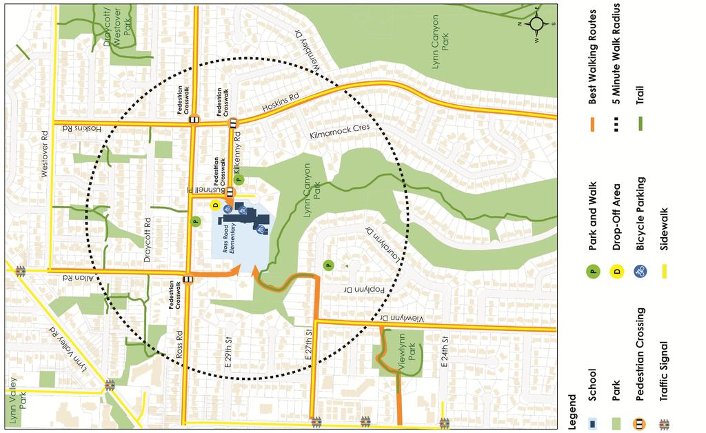
82
Woodward Hill Elementary School School Safety and Operation Review
 Address: 6082-142 nd Street Surrey, BC, V3X 1C1 Site Visit: March 7, 2011 Principal Anne Mackie Report Date: November 25, 2011 Phone: (604) 594-2408 Email: Mackie_A@sd36.bc.ca The following report is one
Classification Criteria
 SCHEDULE D TO RECOMMENDED OFFICIAL PLAN AMENDMENT NO. 40 SCHEDULE C-4 Road Criteria Criteria Traffic Service Objective Land Service/Access Typical Daily Traffic Volume Flow characteristics Travel Speed
Roadway Classification Review
 District of North Vancouver 355 West Queens Road North Vancouver British Columbia V7N 4N5 Roadway Classification Review District of North Vancouver January 2013 District of North Vancouver Roadway Classification
Active Transportation Infrastructure Investment A Business Case
 Active Transportation Infrastructure Investment A Business Case In 2016, the Real Estate Foundation awarded the Capital Regional District a $50,000 grant for Shifting Gears: Land Use Change through Active
Corporate. Report COUNCIL DATE: May 25, 1998 NO: R1500 REGULAR COUNCIL. TO: Mayor & Council DATE: April 27, 1998
 R1500 : Traffic Safety at 25 Avenue and 128 Street Intersection Corporate NO: R1500 Report COUNCIL DATE: May 25, 1998 REGULAR COUNCIL TO: Mayor & Council DATE: April 27, 1998 FROM: General Manager, Engineering
Sardis Elementary School Road Safety Plan. Produced by: Sardis Elementary School - Safer School Travel Team in cooperation with Safer City
 Sardis Elementary Road Safety Plan Produced by: Sardis Elementary - Safer Travel Team in cooperation with Safer City Plan completed in January 2016 1 Acknowledgements It takes commitment and community
SAFE ROUTES TO SCHOOL
 SAFE ROUTES TO SCHOOL Forest Ridge Elementary School Existing Conditions and ACTION PLAN > Oak Creek - Franklin Joint School District Table of Contents CONTEXT Enrollment Boundaries
Edgemont Village Traffic and Parking Technical Report January 2014
 Edgemont Village Traffic and Parking Technical Report January 2014 In the fall of 2013, the District of North Vancouver engaged consultants to assess existing intersection and parking conditions in Edgemont
EXECUTIVE SUMMARY. Vision
 Vision Walking and bicycling in Salt Lake City will be safe, convenient, comfortable, and viable transportation options that connect people to places, foster recreational and economic development opportunities,
SAFE ROUTES TO SCHOOL
 SAFE ROUTES TO SCHOOL Edgewood Elementary School Existing Conditions and ACTION PLAN > Oak Creek - Franklin Joint School District Table of Contents CONTEXT Enrollment Boundaries Enrollment
CONNECTING PEOPLE TO PLACES
 CONNECTING PEOPLE TO PLACES 82 EAST BENCH MASTER PLAN 07 Introduction The East Bench transportation system is a collection of slow moving, treelined residential streets and major arteries that are the
POLICY: TRAFFIC CALMING
 2006 MAY REFERENCE: COUNCIL APPROVED BY COUNCIL MAY 23, 2006 CITY OPERATIONS - NO. 608 POLICY: TRAFFIC CALMING A. All requests for traffic calming within the City shall be considered in accordance with
C/CAG. Sunnybrae Elementary School Walking and Bicycling Audit. San Mateo-Foster City School District JUNE 2013
 Sunnybrae Elementary School Walking and Bicycling Audit JUNE 2013 San Mateo-Foster City School District C/CAG City/County Association of Governments of San Mateo County SUNNYBRAE ELEMENTARY SCHOOL WALKING
Vallecito Elementary School. Travel Plan
 Vallecito Elementary School Travel Plan TABLE OF CONTENTS 1. PURPOSE... 1 1.1. SR2S PLANNING, IMPLEMENTATION AND MONITORING... 1 1.2. MARIN COUNTY MEASURE A... 1 2. VALLECITO ELEMENTARY SCHOOL PROFILE...
Chapter 7. Transportation. Transportation Road Network Plan Transit Cyclists Pedestrians Multi-Use and Equestrian Trails
 Chapter 7 Transportation Transportation Road Network Plan Transit Cyclists Pedestrians Multi-Use and Equestrian Trails 7.1 TRANSPORTATION BACKGROUND The District of Maple Ridge faces a number of unique
CITY OF WEST KELOWNA COUNCIL POLICY MANUAL
 CITY OF WEST KELOWNA COUNCIL POLICY MANUAL Page 1 of 7 DEPARTMENT: Engineering Services SUBJECT: Traffic Calming Policy (Revised June 6, 2017) Policy Statement: The provision of traffic calming measures
CITY OF OAK CREEK SAFE ROUTES TO SCHOOL ACTION PLAN. East Middle School
 CITY OF OAK CREEK SAFE ROUTES TO SCHOOL ACTION PLAN East Middle School CITY OF OAK CREEK SAFE ROUTES TO SCHOOL ACTION PLAN East Middle School Why Safe Routes to School? Safe Routes to School ( SRTS ) is
o n - m o t o r i z e d transportation is an overlooked element that can greatly enhance the overall quality of life for the community s residents.
 N o n - m o t o r i z e d transportation is an overlooked element that can greatly enhance the overall quality of life for the community s residents. 84 Transportation CHAPTER 11 INTRODUCTION Transportation
Welcome. If you have any questions or comments on the project, please contact:
 Welcome This drop-in public open house is intended to provide information about the Bay Street bike lanes project. This project proposes a dedicated cycling facility along Bay Street between Aberdeen Avenue
City of Elizabeth City Neighborhood Traffic Calming Policy and Guidelines
 City of Elizabeth City Neighborhood Traffic Calming Policy and Guidelines I. Purpose: The City of Elizabeth City is committed to ensure the overall safety and livability of residential neighborhoods. One
CITY OF ABBOTSFORD TRANSPORTATION AND TRANSIT MASTER PLAN
 CITY OF ABBOTSFORD TRANSPORTATION AND TRANSIT MASTER PLAN EXECUTIVE COMMITTEE MONDAY, OCTOBER 2, 2017 TRANSPORTATION & TRANSIT AGENDA 1. Plan Overview 2. Shaping Influences 3. Existing Conditions and What
Prepared For: Shieldbay Developments Inc. c/o Matson, McConnell Ltd. 2430A Bloor Street West Toronto, Ontario M6S 1P9.
 Prepared For: Shieldbay Developments Inc. c/o Matson, McConnell Ltd. 2430A Bloor Street West Toronto, Ontario M6S 1P9 Prepared By: URS Canada Inc. 4 th Floor, 30 Leek Crescent Richmond Hill, Ontario L4B
Safer Cycling: How the City of Vancouver is Proactively Improving Cycling Safety
 Safer Cycling: How the City of Vancouver is Proactively Improving Cycling Safety Brian Patterson, MCIP, RPP Urban Systems 2015 Canadian Association of Road Safety Professionals (CARSP) Conference Session
Solana Beach Comprehensive Active Transportation Strategy (CATS)
") Solana Beach Comprehensive Active Transportation Strategy (CATS) 3.0 Goals & Policies The Solana Beach CATS goals and objectives outlined below were largely drawn from the Solana Beach Circulation Element
Solana Beach Comprehensive Active Transportation Strategy (CATS) 3.0 Goals & Policies The Solana Beach CATS goals and objectives outlined below were largely drawn from the Solana Beach Circulation Element
Bikeway action plan. Bicycle Friendly Community Workshop March 5, 2007 Rochester, MN
 Bikeway action plan Summary The was held on March 5, 2007 at the Rochester Mayo Civic Center. The workshop was hosted by Rochester-Olmsted County Planning Department in collaboration with the League of
Sebastopol Charter School Traffic Management Plan
 Sebastopol Charter School The serves as the working document in support of these essential goals: to ensure the safety and efficiency of student arrival to and departure from school to ensure the safety
complete streets design and construction standards public primer City of Edmonton
 complete streets design and construction standards public primer City of Edmonton introduction Complete Streets are streets for everyone: people who walk, wheel, bike, take transit, or drive. They are
Winnipeg Walk Bike Projects Downtown Tire Talk - Summary
 Winnipeg Walk Bike Projects Downtown Tire Talk - Summary Downtown Projected Bike Lane System Connecting The Forks to the Exchange District (Fort Street, Garry Street & The Forks to Assiniboine Connection)
PEDESTRIAN ACTION PLAN
 ATTACHMENT 2 CITY OF SANTA MONICA PEDESTRIAN ACTION PLAN CITY OF SANTA MONICA PEDESTRIAN ACTION PLAN This page intentionally left blank EXECUTIVE SUMMARY CHAPTER 1 EXECUTIVE SUMMARY Setting the Stage
City of Birmingham Draft Multi-modal Transportation Plan
 City of Birmingham Draft Multi-modal Transportation Plan City Commission Public Hearing Monday, November 25, 2013 7:30 pm Norman Cox, PLA, ASLA The Greenway Collaborative, Inc. Ann Arbor, Michigan The
2014/2015 BIKE ROUTE PLAN 83 AVENUE PROTECTED BIKE LANE
 About the Project 2014/2015 BIKE ROUTE PLAN The City of Edmonton is planning a major bike route on the south side of Edmonton. This bike route is one part of a plan to provide citizens with transportation
Nanaimo Transportation Master Plan. Phase 1 Consultation Summary
 Nanaimo Transportation Master Plan Phase 1 Consultation Summary Transportation Advisory Committee Meeting Wednesday December 12, 2012 Agenda Study Update Phase 1 Consultation Process Phase 1 Consultation
TABLE OF CONTENTS. Executive Summary
 Executive Summary Background... ES-1 Pedestrian Network... ES-2 Bikeway Network... ES-2 Collision History... ES-2 Public Input... ES-4 Conclusions and Recommendations... ES-4 1. Introduction and Setting
APPENDIX E Needs Assessment
 APPENDIX E Needs Assessment Active Transportation Needs Assessment Technical Background This appendix provides the technical background supporting the findings presented in Section 3 of the report. Developed
Improving Cyclist Safety at the Dundas Street West and Sterling Road Intersection
 STAFF REPORT ACTION REQUIRED Improving Cyclist Safety at the Dundas Street West and Sterling Road Intersection Date: August 17, 2012 To: From: Wards: Reference Number: Public Works and Infrastructure Committee
Tonight is for you. Learn everything you can. Share all your ideas.
 Strathcona Neighbourhood Renewal Draft Concept Design Tonight is for you. Learn everything you can. Share all your ideas. What is Neighbourhood Renewal? Creating a design with you for your neighbourhood.
City of Novi Non-Motorized Master Plan 2011 Executive Summary
 City of Novi Non-Motorized Master Plan 2011 Executive Summary Prepared by: February 28, 2011 Why Plan? Encouraging healthy, active lifestyles through pathway and sidewalk connectivity has been a focus
CITY OF COCOA BEACH 2025 COMPREHENSIVE PLAN. Section VIII Mobility Element Goals, Objectives, and Policies
 CITY OF COCOA BEACH 2025 COMPREHENSIVE PLAN Section VIII Mobility Element Goals, Objectives, and Policies Adopted August 6, 2015 by Ordinance No. 1591 VIII MOBILITY ELEMENT Table of Contents Page Number
TRAFFIC CALMING GUIDE FOR TORONTO CITY OF TORONTO TRANSPORTATION SERVICES DIVISION
 TRAFFIC CALMING GUIDE FOR TORONTO CITY OF TORONTO TRANSPORTATION SERVICES DIVISION CITY OF TORONTO TRANSPORTATION SERVICES DIVISION 2016 TRAFFIC CALMING GUIDE FOR TORONTO TABLE OF CONTENTS Introduction
Centennial Neighbourhoods Transportation Management Plan Summary of Phase 1 Consultation. Overview of Issues
 1 Centennial Neighbourhoods Transportation Management Plan Summary of Phase 1 Consultation The Centennial Neighbourhoods Transportation Management Plan (CNTMP) is being undertaken to support the Secondary
MASTER BICYCLE AND PEDESTRIAN PLAN
 VILLAGE OF NORTHBROOK MASTER BICYCLE AND PEDESTRIAN PLAN DRAFT PLAN OPEN HOUSE May 2, 2018 AGENDA 1. Community Engagement 2. Vision and Goals 3. General Structure of Plan 4. Recommendations Overview 5.
WELCOME. City of Greater Sudbury. Transportation Demand Management Plan
 WELCOME City of Greater Sudbury Transportation Demand Management Plan Public Consultation Session St. Andrew s Place, Activity Hall 111 Larch Street Wednesday September 13, 2017 6:00 to 8:00 pm Welcome
Arlington Public Schools Abingdon Elementary School Site Evaluation Preliminary Transportation Findings
 Arlington Public Schools Abingdon Elementary School Site Evaluation Preliminary Transportation Findings Arlington County Public Facilities Review Committee (PFRC) November 19, 2014 SAN ANTONIO-BEXAR COUNTY
Downey Road. Transportation Improvement Study
 Downey Road Transportation Improvement Study Workshop 2 Participant Handbook Workshop 1 May 18 and 19, 2016 Workshop 2 June 23 and 28, 2016 Prepared By: City of Guelph Paradigm Transportation Solutions
Ormond & McKinnon Walks Response to Draft Glen Eira Community Plan
 Response to Draft Glen Eira Community Plan We would like to take this opportunity to thank Glen Eira City Council for the opportunity to comment on the Glen Eira Draft Community Plan. Below is an outline
STONY PLAIN ROAD STREETSCAPE
 Jasper Place Revitalization Strategy: Vision The people involved in the Jasper Place Revitalization Strategy envision: Goal 1: Feeling safe in our community Create a community where feeling safe is common--where
S A F E R O U T E S T O S C H O O L H E R M A N TOW N S C H O O L S A N D P R O C TO R S C H O O L S P L A N A P P R OVA L S
 S A F E R O U T E S T O S C H O O L H E R M A N TOW N S C H O O L S A N D P R O C TO R S C H O O L S P L A N A P P R OVA L S WHAT IS SAFE ROUTES TO SCHOOL? In 1969, nearly 50% of children walked or rode
10.0 CURB EXTENSIONS GUIDELINE
 10.0 CURB EXTENSIONS GUIDELINE Road Engineering Design Guidelines Version 1.0 March 2017 City of Toronto, Transportation Services City of Toronto Page 0 Background In early 2014, Transportation Services
ACTIVE TRANSPORTATION
 ACTIVE TRANSPORTATION Mobility 2040 Supported Goals Improve the availability of transportation options for people and goods. Support travel efficiency measures and system enhancements targeted at congestion
Creating walkable, bikeable and transit-supportive communities in Halton
 Creating walkable, bikeable and transit-supportive communities in Halton By presenting current research and best practices, the information in this paper is meant to support and broaden discussion on how
University of Victoria Campus Cycling Plan Terms of Reference. 1.0 Project Description
 University of Victoria Campus Cycling Plan Terms of Reference 1.0 Project Description The Campus Cycling Plan, a first for the University, will provide a comprehensive and coordinated approach to support
A Matter of Fairness: ROCOG s Environmental Justice Protocol. What is Mobility Limitation?
 No Person Left Behind What is Mobility Limitation? What is the Access Limitation? Environmental Justice population should be provided adequate mobility & access to meet their needs; Identify acceptable
Proposed. City of Grand Junction Complete Streets Policy. Exhibit 10
 Proposed City of Grand Junction Complete Streets Policy Exhibit 10 1 City of Grand Junction Complete Streets Policy Vision: The Complete Streets Vision is to develop a safe, efficient, and reliable travel
C C C
 C-012-001 Thank you for your support for the creation of new public space and nonmotorized access between downtown and the waterfront through the Overlook Walk, the East-West Connections, and the Promenade.
Bicycle and Pedestrian Plans and Improvements
 Bicycle and Pedestrian Plans and Improvements Presented to the City Council By Randle Harwood, Planning and Development, and Richard Zavala, Parks and Community Services September 24, 2013 Purpose Review
Transportation Assessment
 Transportation Assessment Midtown Open House February 10, 2018 Overview Midtown in Focus Overview & Purpose of Today Transportation Assessment overview Summary of Transportation work to date Review & Analysis
Pattullo Bridge Replacement Project Community Connections Phase 2 Consultation. Appendix 3: Open House Display Boards
 Replacement Project Community Connections Phase 2 Consultation Appendix 3: Open House Display Boards November 2016 Welcome! Welcome to the Replacement Project Public Open House We Want to Hear from You
Sixth Line Development - Transit Facilities Plan
 Memorandum Date: November 13, 2012 To: From: c.c. Subject: Rob Freeman (Freeman Planning) Kevin Phillips Sixth Line Development - Transit Facilities Plan 33016631 This memo was prepared to review the transit
REGIONAL BICYCLE AND PEDESTRIAN DESIGN GUIDELINES
 REGIONAL BICYCLE AND PEDESTRIAN DESIGN GUIDELINES November 16, 2011 Deb Humphreys North Central Texas Council of Governments Bicycle and Pedestrian Advisory Committee Snapshot of the Guide 1. Introduction
Kelowna On the Move. Pedestrian and Bicycle Master Plan
 Kelowna On the Move Pedestrian and Bicycle Master Plan Executive Summary April 2016 Purpose of the Plan The Pedestrian and Bicycle Master Plan identifies infrastructure, planning, and policy requirements
TOWN OF CHAPEL HILL POLICY AND PROCEDURES FOR TRAFFIC CALMING MEASURES
 TOWN OF CHAPEL HILL POLICY AND PROCEDURES FOR TRAFFIC CALMING MEASURES (Adopted by the Town Council on June 30, 2004) (Revised December 6, 2010) (Revised February 8, 2016) POLICY AND PROCEDURES FOR TRAFFIC
Laura Secord. PAC -- Process and Action Plan Updates
 Laura Secord PAC -- Process and Action Plan Updates OVERVIEW 1. Process Review 2. Stakeholder Actions 1. City of Vancouver 2. Other Stakeholders 3. School Actions 4. PAC Actions 3. Next Steps PROCESS REVIEW
A CHANGING CITY. of Edmonton, it is essential that it reflects the long-term vision of the City.
 A CHANGING CITY By the year 2040, Edmonton will be home to more than 1 million people. To accommodate growth and support a healthy and compact city, we need a new approach to development/redevelopment
2014/2015 BIKE ROUTE PLAN 83 AVENUE PROTECTED BIKE LANE
 About the Project The City of Edmonton is planning a major bike route on the southside of Edmonton. The Strathcona Bike Route will connect the communities of Strathcona, Garneau and the University area,
Public Information Centre
 WELCOME Public Information Centre Father Tobin Road Lougheed Middle School - Library Wednesday November 7, 2012 7:00 p.m.to 9:00 p.m. Please sign in Neighbourhood Traffic Calming Guide Background The City
ALBERTA AVENUE WHAT WE HEARD REPORT BUILDING GREAT NEIGHBOURHOODS
 ALBERTA AVENUE WHAT WE HEARD REPORT BUILDING GREAT NEIGHBOURHOODS FEBRUARY 2019 EXECUTIVE SUMMARY Starting in 2019, Alberta Avenue will see the replacement and enhancement of its aging collector and local
Complete Streets. Designing Streets for Everyone. Sarnia
 Complete Streets Designing Streets for Everyone Sarnia Complete Streets ~ Sarnia ~ 2018 Introduction Our City is made up of a network of streets that we use to go for a walk, cycle to work, drive to the
NEWMARKET UPHAM S CORNER
 SOUTH STATION Planning Initiative NEWMARKET UPHAM S CORNER COLUMBIA ROAD (P) FOUR CORNERS/GENEVA Working Advisory Group (WAG) Meeting #5 TALBOT AVENUE MORTON STREET BLUE HILL AVE/CUMMINS HWY (P) RIVER
Appendix A. Road Classification Review of Outstanding Issues and Proposed Classifications (All Wards) Staff Report Road Classification System
 Staff Report Road Classification System") Appendix A Road Classification Review of Outstanding Issues and Proposed Classifications (All Wards) Staff Report 2000 A.1 of A.10 A.2 of A.10 STAFF REPORT January 26, 2000 To: From: Works Committee Barry
Appendix A Road Classification Review of Outstanding Issues and Proposed Classifications (All Wards) Staff Report 2000 A.1 of A.10 A.2 of A.10 STAFF REPORT January 26, 2000 To: From: Works Committee Barry
As the Toronto Transit Commission (TTC) operates a transit service on Avenue Road, City Council approval of this report is required.
 operates a transit service on Avenue Road, City Council approval of this report is required.") REPORT FOR ACTION Corridor Safety Review - Avenue Road Date: September 27, 2017 To: Toronto and East York Community Council From: Acting Director, Transportation Services, Toronto and East York District
REPORT FOR ACTION Corridor Safety Review - Avenue Road Date: September 27, 2017 To: Toronto and East York Community Council From: Acting Director, Transportation Services, Toronto and East York District
Memorandum. Sunday, July 13, Saturday, July 19, 2014
 Memorandum To: David Lowin, Brooklyn Bridge Park Corporation From: Daniel Schack, AICP, PTP Date: Re: Brooklyn Bridge Park Pier 5/6 Loop Road Traffic Study Project No: 14-01-2407 At the request of Brooklyn
EUCLID AVENUE PARKING STUDY CITY OF SYRACUSE, ONONDAGA COUNTY, NEW YORK
 EUCLID AVENUE PARKING STUDY CITY OF SYRACUSE, ONONDAGA COUNTY, NEW YORK CITY OF SYRACUSE DEPARTMENT OF PUBLIC WORKS 1200 CANAL STREET EXTENSION SYRACUSE, NEW YORK 13210 DRAFT REPORT DATE: November 13,
City of Wayzata Comprehensive Plan 2030 Transportation Chapter: Appendix A
 A1. Functional Classification Table A-1 illustrates the Metropolitan Council s detailed criteria established for the functional classification of roadways within the Twin Cities Metropolitan Area. Table
CITY OF OTTAWA ROADWAY MODIFICATION APPROVAL UNDER DELEGATED AUTHORITY
 RMA-2015-ATM-038 CITY OF OTTAWA ROADWAY MODIFICATION APPROVAL UNDER DELEGATED AUTHORITY DATE: April 22, 2015 SUBJECT Approval of Roadway Modifications Recommended through an Area Traffic Management Study
Chapter 2. Bellingham Bicycle Master Plan Chapter 2: Policies and Actions
 Chapter 2 Bellingham Bicycle Master Plan Chapter 2: Policies and Actions Chapter 2: Policies and Actions The Bicycle Master Plan provides a road map for making bicycling in Bellingham a viable transportation
Safe Routes to School Comprehensive Plan
 Safe Routes to School Comprehensive Plan City of Apple Valley Dakota County, MN May 2010 Prepared by: Project Background The Statewide Health Improvement Program (SHIP) aims to help Minnesotans live longer,
West Dimond Blvd Upgrade Jodhpur Street to Sand Lake Road
 West Dimond Blvd Jodhpur St to Sand Lake CSS Transportation Project Summary Municipality of Anchorage Project # 05 005 Project Manager: John Smith, P.E. (MOA PM&E) Project Administrator: Julie Makela,
Bicycle Master Plan Goals, Strategies, and Policies
 Bicycle Master Plan Goals, Strategies, and Policies Mobilizing 5 This chapter outlines the overarching goals, action statements, and action items Long Beach will take in order to achieve its vision of
TRAFFIC ACTION PLAN. North Central Neighborhood CITY OF SAN MATEO
 TRAFFIC ACTION PLAN North Central Neighborhood CITY OF SAN MATEO Draft February 2017 Table of Contents Introduction... 1 The Traffic Forum Process... 4 Neighborhood Traffic Issues... 6 Neighborhood Recommendations
Welcome! Public Open House on UBC s Transportation Plan
 1 Welcome! Public Open House on UBC s Transportation Plan Public open house hours: to When it comes to on-campus transportation, what do you think is working well and what are some opportunities for improvement?
County of Spartanburg South Carolina
 County of Spartanburg South Carolina Traffic Calming Program June 2012 (Revised/Program on Hold) PURPOSE The potential negative impacts from vehicular traffic on residential roads have been a longstanding
TRANSPORTATION NEEDS ASSESSMENT
 TRANSPORTATION NEEDS ASSESSMENT A travel demand analysis was carried out to determine the operational issues and the potential benefit that adding traffic capacity would have on the road network. All the
Byron Avenue. Public Meeting. Thursday June 16, Traffic Calming Design Sherbourne Road to Island Park Drive
 Byron Avenue Traffic Calming Design Sherbourne Road to Island Park Drive Public Meeting Thursday June 16, 2016 Our Lady of Fatima Parish 153 Woodroffe Avenue 6 9pm 1 Project Summary Area Projects Background
Doull Elementary School
 Doull Elementary School Safe Routes to School Walking Audit and Recommendations WalkDenver Fall 2013 Doull Elementary School (ECE grade 5) 2520 South Utica Street, Denver 80219 This project was supported
WALK- AND bike-friendly TURLOCK
 WALK- AND bike-friendly TURLOCK Ideas to Encourage Walking and Biking Benefits to the COMMUNITY Get Connected People who walk and bike have many more opportunities for casual interactions with friends
TRAFFIC ACTION PLAN. Laurie Meadows Neighborhood CITY OF SAN MATEO
 TRAFFIC ACTION PLAN Laurie Meadows Neighborhood CITY OF SAN MATEO Draft January 2017 Table of Contents Introduction... 2 The Traffic Forum Process... 5 Neighborhood Traffic Issues... 7 Neighborhood Recommendations
City of White Rock. Strategic Transportation Plan. May 16, 2005
 City of White Rock Strategic Transportation Plan May 16, 2005 1 Outline Scope of Plan & Approach Council input and direction Key issues based on existing conditions Range of strategies to consider? Next
General Plan Circulation Element Update Scoping Meeting April 16, 2014 Santa Ana Senior Center, 424 W. 3rd Street, Santa Ana, CA 92701
 General Plan Circulation Element Update Scoping Meeting April 16, 2014 Santa Ana Senior Center, 424 W. 3rd Street, Santa Ana, CA 92701 Meeting Agenda 1. Purpose of Scoping Meeting 2. Project Overview 3.
WELCOME Public Information Centre
 WELCOME Public Information Centre Fernforest Drive Brampton Soccer Centre Community Room #2 Tuesday January 19, 2016 6:30 p.m.to 9:00 p.m. Please sign in Neighbourhood Traffic Calming Guide Background
PRINCE GEORGE S PLAZA METRO AREA PEDESTRIAN PLAN
 PRINCE GEORGE S PLAZA METRO AREA PEDESTRIAN PLAN May 28, 2008 Agenda Welcome and introductions Project overview and issue identification Planning context and strengths Design challenges and initial recommendations
Glebe Neighbourhood Cycling Plan
 Glebe Neighbourhood Cycling Plan Summary of Public Comments received after June 5 th Public Information Session Comment STUDY NETWORK CS9, CS8, E, E0 CS4, E CS4 CS8 E Suggestions for alternate cycling
Moving Cambridge. City of Cambridge Transportation Master Plan Public Consultation Centre. March 7, :00 8:00 PM.
 City of Cambridge Transportation Master Plan Public Consultation Centre March 7, 2018 5:00 8:00 PM Region of Waterloo City of Cambridge Transportation Master Plan Public Consultation Centre March 7, 2018
Chapter 6 Transportation Plan
 Chapter 6 Transportation Plan Transportation Plan Introduction Chapter 6 Transportation Plan Transportation Plan Introduction This chapter describes the components of Arvada s transportation system, comprised
Aitkin School Routing Plan July 2010
 Aitkin School Routing Plan July 2010 Prepared by: Arrowhead Regional Development Commission Regional Planning Division Aitkin School Routing Plan July 2010 Aitkin School Routing Plan July 2010 Prepared
UBC Vancouver Transportation Status Report Fall 2014
 UBC Vancouver Transportation Status Report Fall 2014 July 2015 1. Introduction... 1 1.1. Context... 1 1.2. Transportation Monitoring Program... 2 1.3. Changes at UBC Affecting Travel Patterns... 4 1.4.
Coquitlam Cross-town Bike Route Improving Bicycle Facilities in a Mature Suburban Environment
 Coquitlam Cross-town Bike Route Improving Bicycle Facilities in a Mature Suburban Environment Sarah Rocchi, Vice-President, Projects, Opus International Consultants (Main Presenter) Catherine Mohoruk,
Toronto Complete Streets Guidelines
 88 90 5.1 Cycling Design Principles 92 5.2 Context-sensitive Cycling Facilities 96 5.3 Key Cycling Elements Cycling infrastructure provides choice in how people are able to move around the city. Cyclists
Bellevue Downtown Association Downtown Bike Series
 Bellevue Downtown Association Downtown Bike Series Meeting 2 Franz Loewenherz Andreas Piller Kyle Potuzak Chris Long October 26, 2017 Today s Agenda: 1) Meeting Purpose 2) 9/28 Meeting Recap 3) Candidate
Clay Street Bridge Replacement Project
 Clay Street Bridge Replacement Project Frequently Asked Questions (FAQs) The project is located in downtown Placerville on Clay Street between US Highway 50 and Main Street and Cedar Ravine Road. The proposed
Develop a Multi-Modal Transportation Strategy (Theme 6)
") DEVELOP A MULTI-MODAL TRANSPORTATION STRATEGY (THEME 6) WHY IS THIS THEME ADDRESSED? Develop a Multi-Modal Transportation Strategy (Theme 6) Statement of Ideal Reduce resident and visitor reliance on single
DEVELOP A MULTI-MODAL TRANSPORTATION STRATEGY (THEME 6) WHY IS THIS THEME ADDRESSED? Develop a Multi-Modal Transportation Strategy (Theme 6) Statement of Ideal Reduce resident and visitor reliance on single