NEIGHBORHOOD STREET ENHANCEMENT PROGRAM IMPLEMENTATION PLAN
|
|
|
- Godwin Sullivan
- 5 years ago
- Views:
Transcription


1 NEIGHBORHOOD STREET ENHANCEMENT PROGRAM IMPLEMENTATION PLAN final draft November 21, 2017


2 NEIGHBORHOOD STREET ENHANCEMENT PROGRAM IMPLEMENTATION PLAN final draft November 21, 2017
3 TABLE OF CONTENTS Table of Contents Executive Summary Introduction Introduction Planning Context Planning Documents San Mateo County General Plan (1986) San Mateo County Comprehensive Bicycle and Pedestrian Plan (CBPP) (2011) San Mateo Countywide Transportation Plan (CTP) (2016) City of Redwood City General Plan (2010) North Fair Oaks (NFO) Community Plan (County of San Mateo; 2011) Stanford in Redwood City Precise Plan (2012) Hoover Area Community Mobility Plan (2009) Other Programs and Policies Traffic Calming Programs Permit Parking Programs Stop Sign on Residential Streets Tree Permits Existing Conditions Roadway System Transit Services Neighborhood Street Enhancement Program Implementation Plan i
4 TABLE OF CONTENTS Caltrain Services Bus Services Bicycle Facilities Pedestrian Facilities Sidewalks Crosswalks Safe Route to School (SRTS) Data Collection Average Daily Traffic (ADT) and Speed Data Turning Movement Counts (TMC) Data Speed Data Speed Limits Collision History Street Lighting Planned Transportation Facilities Stanford In Redwood City Precise Plan EIR Precise Plan Roadway Summary Performance Roadway Segment Average Daily Traffic Mitigation Measures and Other Proposed Improvements Transit Improvements ii Neighborhood Street Enhancement Program Implementation Plan
5 TABLE OF CONTENTS Bicycle Improvements Pedestrian Improvements Neighborhood Outreach and Feedback Introduction Approach Feedback Pre-Workshop Outreach Efforts First Round of Neighborhood Workshops Online Survey Second Round of Neighborhood Workshops Third Round of Neighborhood Workshops Final Recommended Projects Traffic Calming Devices Final Recommended Projects Prioritization and Cost Estimates Immediate (High Priority) Improvements Conceptual Design Near-Term (Medium Priority) Improvements Long-Term (Low Priority) Improvements Potential Funding Safe Routes to Schools Green Infrastructure Grants, C/CAG Stanford in Redwood City Development Agreement Neighborhood Street Enhancement Program Implementation Plan iii
6 TABLE OF CONTENTS Tables Table 1. Planning Documents and Relevant Contents Table 2. Roadway Classification for the NSEP Study Area Table 3. Mode Use to School Table 4. Available Average Daily Traffic Counts Table 5. Available Turning Movement Counts Table 6. Available Speed Surveys Table 7. Planned Pedestrian and Bicycle Facilities by Source Table 8. Level of Service and Delay (Existing and Near Term with Project) Table 9. Roadway Segment Average Daily Traffic (Existing and Near Term with Project) Table 10. s and Mitigation Measures Table 11. Precise Plan Roadway Design Standards Table 12. Key Areas of Concerns Friendly Acres Workshop # Table 13. Preferred Solutions Friendly Acres Workshop # Table 14. Key Areas of Concerns North Fair Oaks Workshop # Table 15. Preferred Solutions North Fair Oaks Workshop # Table 16. Key Areas of Concerns Redwood Village Workshop # Table 17. Preferred Solutions Redwood Village Workshop # Table 18. Other Preferred Solutions Table 19. Overall Questions, Comments, and Concerns iv Neighborhood Street Enhancement Program Implementation Plan
7 TABLE OF CONTENTS Table 20. Neighborhood Discussion Summary Friendly Acres Workshop # Table 21. Neighborhood Discussion Summary North Fair Oaks Workshop # Table 22. Neighborhood Discussion Summary Redwood Village Workshop # Table 23. Improvements and Descriptions Shared Cost Table 24. Improvements and Descriptions Friendly Acres Table 25. Improvements and Descriptions North Fair Oaks Table 26. Improvements and Descriptions Redwood Village Table 27. Immediate (High Priority) Improvements Table 28. Near-Term (Medium Priority) Improvements Table 29. Long-Term (Low Priority) Improvements Figures Figure 1. Residential Area Boundaries Figure 2. SamTrans Bus Route in Study Area (Source: SamTrans System Maps) Figure 3. Existing Bicycle Facilities Figure 4. Collision Map ( ) Figure 5. Street Light Inventory Figure 6. Existing and Planned Bicycle Facilities Figure 7. Proposed Mitigation Measures Figure 8. Neighborhood Outreach Approach Figure 9. Pre-Workshop Neighborhood Comments Figure 10. Online Survey Question 1 Surveyee Identity Neighborhood Street Enhancement Program Implementation Plan v
8 TABLE OF CONTENTS Figure 11. Online Survey Question 2 Population Distribution Figure 12. Online Survey Question 8 Major Concerns Figure 13. Online Survey Question 9 Preferred Traffic Calming Measures Figure 14. Options for Improvements (Friendly Acres) Figure 15. Prioritization Results (Friendly Acres) Figure 16. Options for Improvements North Fair Oaks Figure 17. Prioritization Results (North Fair Oaks) Figure 18. Options for Improvements Redwood Village Figure 19. Prioritization Results (Redwood Village) Figure 20. Immediate (High Priority) Improvements Figure 21. Near-Term (Medium Priority) Improvements Figure 22. Long-Term (Low Priority) Improvements vi Neighborhood Street Enhancement Program Implementation Plan
9 TABLE OF CONTENTS Appendix Appendix A. First Neighborhood Workshops Materials A1. Postcards and Flyers A2. PowerPoint Presentations A3. Exhibit Boards A4. Comments and Feedback Appendix B. Online Survey Statistics and Results Appendix C. Second Neighborhood Workshops Materials C1. Postcards and Flyers C2. PowerPoint Presentations C3. Exhibit Boards C4. Comments and Feedback Appendix D. Third Neighborhood Workshops Materials D1. Postcards D2. PowerPoint Presentations D3. Exhibit Boards D4. Comments and Feedback Appendix E. Conceptual Designs Neighborhood Street Enhancement Program Implementation Plan vii
10
11 This Page Intentionally Left Blank.
12

13 EXECUTIVE SUMMARY EXECUTIVE SUMMARY Figure ES-1. Residential Area Boundaries In 2013, the City of Redwood City approved the Stanford in Redwood City Precise Plan for a new 35-acre Stanford University office campus. The site is located in the southeast portion of the City of Redwood City along Highway 101 (US-101), bordering three residential neighborhoods: Friendly Acres, Redwood Village, and North Fair Oaks. As part of the project s approved Development Agreement, the University allocated $1.5 million to the City s Neighborhood Street Enhancement Program (NSEP). These funds were allocated to the NESP to improve traffic safety, mobility, and accessibility, and provide enhanced streetscapes in the three adjacent residential neighborhoods. The funds are to be allocated equally between the three neighborhoods. Figure ES-1 presents an overview of the three residential neighborhoods. In addition to the NSEP, the Environmental Impact Report (EIR) of the development has identified improvements aimed to alleviate traffic impact on the adjacent neighborhoods. These improvements are set aside from the NSEP and will be, at the University s cost, implemented in the future. Planning Context City, County, and regional plans create a foundation that helps understand long-term planning visions and goals, and potential or scheduled planning decisions around and within the three NSEP neighborhoods. The consultant studied relevant planning documents to ensure the NSEP proposed improvement projects are consistent with these plans, which includes the County and City General Plan, County Comprehensive Bicycle and Pedestrian Plan, Countywide Transportation Plan, the Stanford in Redwood City Precise Plan, the North Fair Oaks Community Plan, and Hoover Area Community Mobility Plan. Existing Conditions The consultant studied existing conditions around and within the NSEP neighborhoods to understand current infrastructure and its deficiencies. The facilities include roadway networks, transit services and amenities, Neighborhood Street Enhancement Program Implementation Plan 1
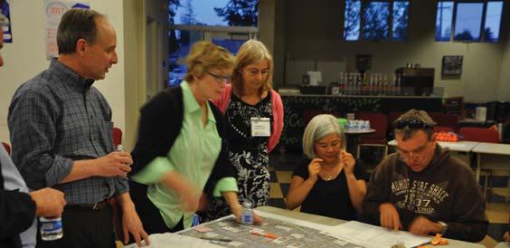
14 EXECUTIVE SUMMARY pedestrian and bicycle facilities, and parking and suggested routes to schools. Traffic and transportation data serves technical review for any potential improvement that might have impact on the current traffic operations. The consultant organized recent and historical traffic counts (average daily traffic counts (ADT) and turning movement counts (TMC)), speed surveys and collision data from the City. This provides a baseline for recommending and prioritizing already proposed improvements during the development of the NSEP Implementation Plan. Neighborhood Street Enhancement Program Implementation Plan Structure This Plan documents the implementation process of the Neighborhood Street Enhancement Program (NSEP). Some key components of the report include: Highlights of the Stanford Development project and its neighborhoods. Figure ES-2 shows the outreach process, which included: mitigation measures; Review of previous neighborhood Neighborhood feedback from the input; impacted neighborhoods; Individual stakeholder interviews Project lists and priorities for Project website and online survey; immediate, near-term, and longterm implementation; Solicit neighborhood input from Opportunities to leverage funding regularly-held neighborhood meetings; through other City and County programs; and, Two neighborhood workshops per neighborhood; and, Other funding opportunities. One joint neighborhood workshop Neighborhood Outreach Overview Neighborhood outreach was focused on for all three neighborhoods to present Proposed Plan. engaging residents from the Friendly Acres, North Fair Oaks, and Redwood Village Figure ES-2. Neighborhood Outreach Approach Relevant City and County policies, guidelines, and programs to NSEP Existing and planned transportation infrastructure and services of all modes Technical data available for traffic and transportation analyses 2 Neighborhood Street Enhancement Program Implementation Plan
 and other stakeholders, information was")
15 EXECUTIVE SUMMARY Materials were translated into Spanish as well as in person translation during the workshops. Interviews During the phone interviews with representatives from each of the three neighborhoods (Redwood Village, Friendly Acres and North Fair Oaks) and other stakeholders, information was solicited regarding: Any past neighborhood discussions of potential improvements Existing neighborhood communication channels (Nextdoor, HOA and network) Best locations and times for neighborhood meetings and workshops Other issues or insights regarding the project First Round of Neighborhood Workshops The first round of the neighborhood workshops introduced participants to the project background and the purpose of the study. Participants first identified areas of concerns and preferred traffic and beautification solutions. Neighborhood concerns regarding specific locations varied between neighborhoods, but parking, speeding, cut-through traffic, beautification, and school safety were common themes shared between groups, including online survey participants. Street lights, high visibility crosswalks, traffic circles, bulb-outs, pedestrian and bicycle pathways, and flashing beacons stood out as preferred solutions. Online Survey In order to collect additional input from residents on enhancements that would create more livable streets, residents of the Friendly Acres, Redwood Village, and North Fair Oaks neighborhoods were asked to complete a survey regarding Neighborhood Streets Enhancement Improvements. Second Round of Neighborhood Workshops The second workshops allowed participants to rank and prioritize the concepts developed by the consultant in response to their concerns and preferences, with consideration for cost and feasibility. Participants of the workshops were also asked to provide additional suggestions or comments, which were then developed into additional feasible improvements. These were also considered as part of the final project prioritization effort. Third Round of Neighborhood Workshop The third workshop was a joint workshop of the three NSEP neighborhoods. This joint workshop consolidated proposed improvement projects in the NSEP study area as a whole. The residents were presented with final recommendations developed based on neighborhood preference and technical analysis. The residents and other participants provided final comments and feedback on project prioritization and proposed conceptual design alternatives of the NSEP. Neighborhood Street Enhancement Program Implementation Plan 3
16 EXECUTIVE SUMMARY Project Recommendations Overview Projects identified and ranked through the neighborhood outreach process were ultimately prioritized based on the following key considerations: Neighborhood preference; Enhanced level of safety; Enhanced level of neighborhood identity, form, and appearance; and, City and County policies on infrastructure development. Based on the NESP fund allocation methodology, the $600,000 for immediate improvements and $750,000 for near-term improvements were to be distributed evenly between the three neighborhoods. Projects costs were assigned their respective neighborhood or, where there was a demonstrable mutual benefit, shared between neighborhoods. Based on these funding and allocation constraints, and the key prioritization considerations above, improvements were ultimately split into three categories. Immediate (High Priority) Improvements are highly preferred by the residents and will be funded with impact fees ($600,000) from the first phase of the Stanford University office campus project. Concepts identified in neighborhood workshops were refined in to feasible and implementable projects. These projects are shown in Figure ES-3. Near-Term (Medium Priority) Improvements will be funded with impact fees from the second phase of the Stanford University office campus project ($750,000). These improvements also represent refinements of preferred concepts identified by residents. These projects are shown in Figure ES-4. Long-Term (Low Priority) Improvements will not be funded through impact fees associated with the Stanford University office campus project. The City and County will seek additional funding sources for these projects, if and when they are determined to be necessary by future analysis. These improvements did receive residents support in workshops, but ranked lower than those identified as immediate or near-term priorities. These projects are shown in Figure ES-5. Project Funding Overview The immediate and near-term priority improvements are anticipated to be funded through the first and second phase impact fees associated with the Stanford University office campus (Stanford in Redwood City Priority Plan). However, this implementation Plan also identifies specific improvements that could potentially receive funding through the City/County Association of Governments of San Mateo County (C/CAG) Safe Routes to Schools and Green Streets Infrastructure Pilot Program. Additionally, the Development Agreement for the Stanford University office campus anticipates construction of bicycle and bus shelter improvements that may partially or completely be applied to improvements identified in this Plan. 4 Neighborhood Street Enhancement Program Implementation Plan
17 EXECUTIVE SUMMARY Figure ES-3. Immediate (High Priority) Improvements Neighborhood Street Enhancement Program Implementation Plan 5
18 EXECUTIVE SUMMARY Figure ES-4. Near-Term (Medium Priority) Improvements 6 Neighborhood Street Enhancement Program Implementation Plan
 Improvements Neighborhood Street")
19 EXECUTIVE SUMMARY Figure ES-5. Long-Term (Low Priority) Improvements Neighborhood Street Enhancement Program Implementation Plan 7

20 EXECUTIVE SUMMARY 8 Neighborhood Street Enhancement Program Implementation Plan
21 1 INTRODUCTION 1 INTRODUCTION This Plan documents the implementation process of the Neighborhood Street Enhancement Program (NSEP). Some key components of the report include: Relevant City and County policies, guidelines, and programs to NSEP Existing and planned transportation infrastructure and services of all modes Technical data available for traffic and transportation analyses Highlights of the Stanford Development project and its mitigation measures Neighborhood feedback from the impacted neighborhoods Project lists and priorities for immediate, near-term, and longterm implementation Opportunities to leverage funding through other City and County programs Other funding opportunities 1.1 Introduction In 2013, the City of Redwood City approved a plan for a new office campus for Stanford University on an approximately 35-acre portion of an existing technology park. The proposed campus is located in the southeast portion of the City of Redwood City along Highway 101 (US-101), bordering three different residential neighborhoods: Friendly Acres, North Fair Oaks, and Redwood Village. Figure 1 presents an overview of the three residential neighborhoods. The Stanford in Redwood City Precise Plan and the Environmental Impact Report (EIR) outline the City s interests and priorities related to transportation and accessibility issues in the vicinity of the new campus. The Precise Plan area is generally bounded by US-101 on the east, Douglas Avenue on the north, Bay Road on the west, and multiple uses along Second Avenue on the south. The area is bisected by Broadway. Recognizing that this development will have significant impacts, primarily on these three key neighborhoods, Stanford University agreed to fund $1.5 million in capital improvements within the Precise Plan area, beyond those identified as specific mitigation measures for significantly impacted intersections. As part of the approved Development Agreement, the funds allocated to the three neighborhoods may be used by the Neighborhood Street Enhancement Program (NSEP) primarily to improve neighborhood traffic safety, mobility, and accessibility, along with the provision of enhanced streetscapes and neighborhood beautification Stanford University applied for and has been granted approval to proceed with the first phase of development. Conditions of approval included completion of mitigation measures required in the Precise Plan EIR and payments for the NSEP under the 2013 development agreement between the City and Stanford University. Plans were finalized in July 2016, and construction began in May Neighborhood Street Enhancement Program Implementation Plan 9
22 1 INTRODUCTION Figure 1. Residential Area Boundaries 10 Neighborhood Street Enhancement Program Implementation Plan


 Adopted in November 1986, the San Mateo County General Plan guides the decision-making process for the future of the unincorporated area.")
23 2 PLANNING CONTEXT 2 PLANNING CONTEXT 2.1 Planning Documents This section details relevant planning documents that will support the Neighborhood Street Enhancement Program (NSEP). These documents have identified goals, policies, and potential improvements that may include the NSEP study area. The following sub-sections describe the purpose and function of each document reviewed. These are followed by Table 1, which summarizes relevant policies within these documents as pertaining to the NSEP San Mateo County General Plan (1986) Adopted in November 1986, the San Mateo County General Plan guides the decision-making process for the future of the unincorporated area. The plan identifies key plans, regulations and agencies that affect planning decisions. The North Fair Oaks neighborhood in the NSEP is one of the unincorporated areas identified in the County General Plan San Mateo County Comprehensive Bicycle and Pedestrian Plan (CBPP) (2011) Adopted in September 2011, the CBPP developed a policy framework and identified existing pedestrian and bicycle facilities and deficiencies to address in planning, design, funding, and implementation of bicycle and pedestrian projects San Mateo Countywide Transportation Plan (CTP) (2016) The San Mateo CTP for 2040 was developed to provide the County with a long-range, comprehensive transportation planning document that sets forth a coordinated planning framework and establishes a systematic transportation planning process for identifying and resolving transportation issues. It identifies planning objectives and priorities to ensure consistency among all transportation plans and programs within the County City of Redwood City General Plan (2010) Adopted in October 2010, the City s General Plan developed a planning blueprint for the growth of Redwood City through The Circulation element identifies goals and policies that apply to the Neighborhood Street Enhancement Program (NSEP) study area. Neighborhood Street Enhancement Program Implementation Plan 11


24 2 PLANNING CONTEXT North Fair Oaks (NFO) Community Plan (County of San Mateo; 2011) Stanford in Redwood City Precise Plan (2012) Hoover Area Community Mobility Plan (2009) The NFO Community Plan is a long-range policy document that establishes goals and policies for several typical planning elements. The Circulation and Parking element in this document identifies existing and potential improvements to the transportation network that increase safety, accessibility and mobility of all user modes. The goals and polices identified in this document apply to the North Fair Oaks neighborhood in the NSEP study area. This Precise Plan is a zoning document with policies, guidelines, and standards that guide decision makers on elements of land use, urban form, and circulation for the transition of existing land uses to the new office campus. This Precise Plan serves as a basis for the NSEP and the proposed improvements in the Precise Plan affect the development of alternatives for the NSEP. The Mobility Plan identified issues and community needs for improving transportation safety and mobility in the vicinity of Hoover Elementary School, bordered by Chestnut Street, Spring Street, Douglas Avenue, and Chew Street. The proposed improvements within the Mobility Plan will serve to guide the NSEP alternative development, particularly in the neighborhoods of Redwood Village and North Fair Oaks. 12 Neighborhood Street Enhancement Program Implementation Plan
25 2 PLANNING CONTEXT Table 1. Planning Documents and Relevant Contents Document San Mateo County General Plan (1986) San Mateo County Comprehensive Bicycle and Pedestrian Plan (2011) Neighborhood Affected North Fair Oaks Friendly Acres Redwood Village North Fair Oaks Relevant Contents Transportation Policies Goals and Objectives Create and maintain Complete Streets that serve all categories of transportation users and goods, providing safe, efficient, comfortable and convenient travel along all streets through an integrated, balanced, multimodal transportation network that meets the needs of all users of streets, roadways, and highways for safe and convenient travel in a manner that is suitable to the rural, suburban or urban context of the General Plan. Policy2.7. Encourage local agencies to provide safe and convenient bicycle and pedestrian infrastructure for underserved communities. Policy 3.3. Provide support for programs that educate drivers, bicyclists and pedestrians about their rights and responsibilities, as well as traffic education and safety programs for adults and youth. Policy 4.1. Comply with the complete streets policy requirements of Caltrans and the Metropolitan Transportation Commission concerning safe and convenient access for bicyclists and pedestrians, and assist local implementing agencies in meeting their responsibilities under the policy. Neighborhood Street Enhancement Program Implementation Plan 13
26 2 PLANNING CONTEXT Document Neighborhood Affected Relevant Contents Roadway System Polices Enhance safety for travel by motorized modes Identify and eliminate roadway and intersection hazards. Consider the use of roundabouts, where appropriate, to improve safety at intersections San Mateo Countywide Transportation Plan (2016) Friendly Acres Redwood Village North Fair Oaks Bicycle and Pedestrian Policies: Complete Streets Comply with the complete streets policy requirements of Caltrans and the Metropolitan Transportation Commission concerning safe and convenient access for bicyclists, and assist local implementing agencies in meeting their responsibilities under the policy. Bicycle and Pedestrian Policies: Traffic Calming Support efforts to calm motor vehicle traffic to enhance travel conditions for bicyclists. In areas with high levels of pedestrian traffic, encourage cities to implement appropriate traffic calming measures to slow approaching car speeds and thus lengthen reaction time available to both drivers and pedestrians in the event of a potential conflict. City of Redwood City General Plan (2010) Friendly Acres Redwood Village Policy BE Support using the concept of complete streets to design construct, operate, and maintain City and private streets to enable safe, comfortable, and attractive access and travel for pedestrians, bicyclists, motorists, and transit users of all ages, abilities, and preferences. Use the complete streets concept to better link the Port, Seaport Center, Pacific Shores, and other employment centers with Downtown and other nearby areas. Policy BE Pursue programs that reduce vehicles speeds and cut-through traffic on local streets. 14 Neighborhood Street Enhancement Program Implementation Plan
27 2 PLANNING CONTEXT Document North Fair Oaks Community Plan (County of San Mateo; 2011) Stanford in Redwood City Precise Plan (2012) Neighborhood Affected North Fair Oaks Friendly Acres Redwood Village North Fair Oaks Relevant Contents Goal 3.2. Improve existing pedestrian facilities (sidewalks, sidewalk furniture, trees, paths, and other facilities), and provide new facilities throughout North Fair Oaks Goals 3.3. Improve bicycle connectivity throughout North Fair Oaks by providing additional designated bicycle facilities such as bike lanes and paths and by improving the safety of existing infrastructure. Circulation Policies Vehicle Circulation. The Redwood City General Plan contains polices to remake Broadway into a complete street, balancing enhanced mobility for transit users, cyclists, and pedestrians with automobile traffic. Vehicle Circulation. The Precise Plan s site development and parking policies promote the use of Bay Road for campus access, conserving Broadway for access to the Friendly Acres neighborhood and the potential streetcar line connection to Downtown. Pedestrian Circulation. A network of pedestrian circulation routes to and through the Precise Plan Area should be provided that maximizes pedestrian access, employing City streets as well as on-site walks and through-building ways. Pedestrian Circulation. Broadway should be the primary pedestrian route linking the Precise Plan Area to points east and west, with the internal Campus Greenway providing off-street circulation through the portion of the campus south of Broadway. Bicycle Circulation. The Precise Plan assumes that bicycle trips to and from the campus will be significant. Class II bicycle lanes are currently striped along Broadway east of the campus between 2nd and 5th Avenues, and a formalized bike route will be extended within the Broadway right-of-way through the campus to Douglas Avenue consistent with the policies of the Redwood City General Plan. Neighborhood Street Enhancement Program Implementation Plan 15
28 2 PLANNING CONTEXT Document Neighborhood Affected Relevant Contents Key Community Needs Safe crossing of Woodside Road Safe crossing of Middlefield Road Safe crossing of railroad tracks Bicycle safety and access Public transit improvements Safer conditions for all who move through the community, particularly for pedestrians Hoover Area Community Mobility Plan (2009) Redwood Village North Fair Oaks Potential Mobility Solutions Bicycling Improvements. This section documents potential solutions for bicycling in the Hoover area, including new bicycle lanes on Middlefield Road and Woodside Road, additional parking facilities and a bicycle education program for the youth. Pedestrian Improvements. This section documents potential solutions for improving walking in the Hoover area, including crosswalk improvements, railroad pedestrian crossing improvements, traffic calming measures on Chestnut, Stambaugh, and Charter Street, and a Safe Routes to School plan for Hoover Elementary School. Transit Improvements. This section documents potential solution to improve transit accessibility and service, including map and signage upgrades, additional bus stops and shelters at selected locations. Source: San Mateo County General Plan (1986); San Mateo County Comprehensive Bicycle and Pedestrian Plan (2011); San Mateo Countywide Transportation Plan (2016); City of Redwood City General Plan (2010); North Fair Oaks Community Plan Update (County of San Mateo; 2011); Stanford in Redwood City Precise Plan (2012); Hoover Area Community Mobility Plan (2009). 16 Neighborhood Street Enhancement Program Implementation Plan
29 2 PLANNING CONTEXT 2.2 Other Programs and Policies Traffic Calming Programs The City of Redwood City Community Development Department manages the traffic calming requests for the Friendly Acres and Redwood Village neighborhoods. Requests are taken via , phone and the City s mobile application myrwc. The Residential Speed Control is an existing program managed by the Department of Public Works of the County of San Mateo. The program allows neighborhoods to request speed control devices. These existing programs provide guidance for the NSEP in developing feasible alternatives. Both the City and County perform analysis on all requests for traffic calming devices; this includes traffic counts, fieldworks, policies, and following standards and guidelines set forth by the California Manual on Uniform Traffic Control Devices (MUTCD), and City and County guidelines and standards Permit Parking Programs The City of Redwood City manages a Residential Permit Parking Program (RPPP) that allows residents (in RPPP designated areas) to park on-street longer than the twohour time restriction. Parking is on a firstcome, first-serve basis; a permit does not guarantee or reserve the permit holder a parking space in the designated residential parking permit area. A residential parking permit is free of charge and each household can apply up to three permits. Currently, there is no RPPP in Friendly Acres or Redwood Village. The City also manages a monthly parking permit program in the downtown area with designated permit parking spaces in Marshall Garage, Main Street Lot, and Sequoia Station Underground Garage. Permit fees range from $60 to $100 monthly depending on privileges and locations. The City is in the process of revising the city ordinance on RPPP to allow for the possibility of overnight residential permit parking areas. There is no permit parking program within the County jurisdiction Stop Sign on Residential Streets The City of Redwood City maintains its own policy and guidelines for stop signs on residential streets. The document states that a stop sign is applied as a Control of right of way at intersections where there is a reason to believe that the intersection does or would not operate within reasonable safety expectations if left to operate as an uncontrolled intersection under the general right of way law. In addition to the objective for the provision of a stop sign, the guidelines states the need for engineering justification when considering a stop sign as a traffic solution. The City also follows the California MUTCD recommendations for stop sign installation Tree Permits The City of Redwood City currently has two tree ordinances that protect and preserve trees in the City: A Street Tree Ordinance protects all street trees growing on public property adjacent to roadways throughout the city. A Tree Preservation Ordinance protects all trees growing on private property with trunk sizes that exceed 38 inches in circumference (twelve inches in diameter) measured between six inches and 36 inches above ground. Tree regulations related to planting, maintenance, and removal are described in Neighborhood Street Enhancement Program Implementation Plan 17
30 2 PLANNING CONTEXT the Municipal Codes Chapter 29 and 35. Anyone who wishes to perform any act on a tree protected by these ordinances or plant a tree in the public right-of-way must first apply for and receive a permit. 18 Neighborhood Street Enhancement Program Implementation Plan
31 3 EXISTING CONDITIONS 3 EXISTING CONDITIONS Before developing the Neighborhood Street Enhancement Program (NSEP) implementation plan and Conceptual Designs for recommended improvements, it is necessary to compile a list of all existing facilities and near-term/future improvements within the NSEP study area. This section summarizes the existing roadway system, transit, pedestrian and bicycle facilities, parking and safe routes to school program within the study area. This section also summarizes all relevant data collected by the consultant, including recent and historical traffic counts (average daily traffic counts (ADT) and turning movement counts (TMC)), speed surveys and collision data from the City. This provides a baseline for recommending and prioritizing already proposed improvements during the development of the NSEP implementation plan. 3.1 Roadway System This section summarizes key arterials, collectors, and local streets potentially impacted by the Stanford in Redwood City Development. These streets could potentially benefit from the NSEP program based on the City of Redwood City s knowledge of the study area, planning documents such as the Stanford in Redwood City Precise Plan, and recent discussions with the three neighborhoods within the NSEP study area. All major roadways analyzed for impacts on traffic flow as a result of the proposed Stanford in Redwood City development are described below. The roadway classifications described are based on City of Redwood City Street Classification and Use, the Countywide Transportation Plan, and the North Fair Oaks Community Plan. Woodside Road (SR-84) is a four-to-six lane east-west arterial that runs between I-280 in the south and US-101 to the north. Woodside Road borders the Redwood Village neighborhood within the NSEP study area. Between Middlefield Road and Spring Street, it has two lanes in each direction and between Spring Street and Broadway, it has three lanes in the eastbound direction and two lanes in the westbound direction. Onstreet parking is prohibited along this roadway and the posted speed limit is 35 miles per hour (mph). In the City of Redwood City Street Classification and Use, Woodside Road is considered a boulevard, which is not eligible for traffic calming. *The City of Redwood City Street Classification and Use can be found in the City of Redwood City Policy and Guidelines for residential traffic calming. Bay Road is an undivided two-to-four lane local street that runs north-south from Beech Street in Redwood City east to Willow Road in Menlo Park. It connects all three NSEP study area neighborhoods: Redwood Village, North Fair Oaks, and Redwood Village. It runs parallel to US 101 within the study area. Bay Road has two lanes in each direction between Woodside Road and Third Avenue and one lane in each direction with a center turn lane from Third Avenue to Florence Street. It provides on-street parking and has a posted speed limit of 30 mph within the study area. Spring Street is an undivided two lane north-south local street that between Woodside Road and Bay Road/Florence Street. It runs parallel to US 101 within the study area. Spring Street serves residential, mixed local business, and industrial uses in the study area. Similar to Bay Road, it connects all three LNS neighborhoods. The Neighborhood Street Enhancement Program Implementation Plan 19
32 3 EXISTING CONDITIONS majority of Spring Street is within unincorporated San Mateo County in the North Fair Oaks Neighborhood. It provides on-street parking and has a posted speed limit of 25 mph within the study area. Middlefield Road is a two-to-four-lane north-south arterial connecting Menlo Park, Atherton, North Fair Oaks and Redwood City. It runs parallel to US 101 within the study area and connects the Redwood Village and North Fair Oaks neighborhoods. The roadway is undivided, with one to two lanes in either direction. Middlefield Road provides angled and parallel on-street parking and has a posted speed limit of 30 mph within the study area. It is fronted by primarily lowdensity commercial and industrial uses, including several automotive repair and service businesses. There are several unsignalized marked pedestrian crossings along Middlefield Road. Broadway is an undivided two-to-four lane north-south roadway that extends from Woodside Road to Fifth Avenue in Redwood City. It runs parallel to US 101 within the study area and connects the Redwood Village and Friendly Acres neighborhoods. Broadway provides direct access to the Stanford Precise Plan sites and serves various commercial and residential land uses. It is a four-lane roadway between Woodside Road to a mid-block signalized crosswalk, near the Stanford buildings at 425 Broadway. From there, Broadway becomes a two-lane roadway with a center left turn lane to Fifth Avenue. On-street parking is permitted on most of Broadway, except between Douglas and Second Avenue. it has a posted speed limit of 30 mph. Broadway serves a transit line (defined as a Transit Street in the City of Redwood City s General Plan) and has Class II and Class III bicycle facilities. Marsh Road is a two-to four lane arterial roadway that extends from Middlefield Road to east of US-101. Marsh Road has a full access interchange with US 101. It lies just outside the Friendly Acres neighborhood between Florence Street and Rolison Road within the study area. Marsh Road has a posted speed limit of 35 mph. Charter Street is a two-lane east-west local street that extends from Middlefield Road to Broadway after which it becomes a cul de sac. It forms the boundary between Redwood Village and North Fair Oaks neighborhoods between El Camino Real and Middlefield Road and lies primarily within the Redwood Village neighborhood. It is fronted by industrial, commercial and residential land uses. It provides on-street parking and has a posted speed limit of 25 mph. Douglas Avenue is a two-lane east-west local street that extends from Middlefield Road to Broadway after which it becomes a cul de sac. It forms the boundary between Redwood Village and North Fair Oaks neighborhoods between Middlefield Road and Bay Road and lies within the Redwood Village neighborhood. It serves industrial and residential land uses and has on-street parking. It is also the boundary of the Stanford in Redwood City development. Second Avenue is a two-lane east-west local street that extends from Williams Avenue to Rolison Road. It connects the North Fair Oaks and Friendly Acres neighborhoods. It serves industrial and residential land uses. Second Avenue provides on-street parking and has a posted speed limit of 25 mph. Fifth Avenue is a two-to-four-lane east-west local street that extends from El Camino Real to Rolison Road. It connects the North Fair Oaks and Friendly Acres neighborhoods. In 20 Neighborhood Street Enhancement Program Implementation Plan
33 3 EXISTING CONDITIONS the study area, the roadway is two-lane and mostly residential with a few commercial uses near the intersections of Bay Road, Edison Way, and Middlefield. It is also fronted by Everest High School. Second Avenue provides on-street parking and has a posted speed limit of 25 mph. Flynn Avenue-Kaynyne Street is a two-lane east-west local street per the City of Redwood City s General Plan between Middlefield Road and Bay Road. It lies within the Redwood Village neighborhood and is primarily fronted by residential land uses. It provides on-street parking. Hurlingame Avenue is a two-lane east-west local street that extends from Middlefield Road to Bay Road. It lies within the North Fair Oaks neighborhood. Hurlingame Avenue is fronted by industrial and residential land uses. It provides on-street parking and has a posted speed limit of 25 mph. parking and has a posted speed limit of 25 mph. Traffic calming devices, speed humps, were installed on this roadway as an earlier mitigation for the Midpoint Technology Park. Rolison Road is a two-lane north-south local street per the City of Redwood City s General Plan between Second Avenue and Marsh Road. It lies within the Friendly Acres neighborhood and is fronted by commercial and residential land uses. It provides onstreet parking and has a posted speed limit of 30 mph. Table 2 provides the roadway classifications adopted by the City of Redwood City s General Plan, 2010; the County of San Mateo s Countywide Transportation Plan, 2016; and the North Fair Oaks Community Plan, Page Street is a two-lane north-south local street per the City of Redwood City s General Plan between Second Avenue and Marsh Road. It lies within the Friendly Acres neighborhood and is primarily fronted by residential land uses. It provides on-street Neighborhood Street Enhancement Program Implementation Plan 21
34 3 EXISTING CONDITIONS Table 2. Roadway Classification for the NSEP Study Area Street City General Plan Countywide Transportation Plan/NFO Community Plan Neighborhood Woodside Road (SR-84) Boulevard Arterial Redwood Village Bay Road Industrial Street Local All three Spring Street Industrial Street Local All three Middlefield Road Transit Street Arterial Redwood Village, North Fair Oaks Broadway Transit Street N/A Redwood Village, Friendly Acres Marsh Road N/A (Menlo Park) Arterial Friendly Acres Charter Street Industrial Street Local Redwood Village Douglas Avenue Industrial Street Local Redwood Village Second Avenue Industrial Street Local Friendly Acres, North Fair Oaks Fifth Avenue Local Local Friendly Acres, North Fair Oaks Flynn Avenue Local N/A Redwood Village Hurlingame Avenue Industrial Street Local North Fair Oaks Page Street Local N/A Friendly Acres Rolison Road Local N/A Friendly Acres Source: Redwood City General Plan (2010); San Mateo Countywide Transportation Plan (2016); North Fair Oaks Community Plan (2011) 22 Neighborhood Street Enhancement Program Implementation Plan

35 3 EXISTING CONDITIONS 3.2 Transit Services Caltrain Services Caltrain serves the regional rail connection for the San Francisco Peninsula and the Santa Clara Valley area. The Redwood City Caltrain Station is the hub for most users in Redwood City, including for commuters from the Redwood Village neighborhood in the NSEP study area. It is located approximately 1.0 mile north of Woodside Road at James Avenue. The Atherton Caltrain Station is approximately half a mile west of Middlefield Road at Dinkelspiel Station Lane. It is easily accessible by the North Fair Oaks neighborhood commuters Bus Services Currently, SamTrans operates Route 270 and 79 within the LNS study area. Route 270 operates to and from the Redwood City Caltrain Station as a loop primarily using Broadway, Marsh Road, and East Bayshore Road in the study area. Route 79 provides school day only service connecting Florence St with Kennedy School through Charter Street and Middlefield Road. The Redwood City Midpoint Caltrain Shuttle provides shuttle service that coincides with train arrivals and departures. Figure 2 shows all bus routes operating within the study area. Neighborhood Street Enhancement Program Implementation Plan 23 Photo Credit: bcx.news.
 24")
36 3 EXISTING CONDITIONS Figure 2. SamTrans Bus Route in Study Area (Source: SamTrans System Maps) 24 Neighborhood Street Enhancement Program Implementation Plan


37 3 EXISTING CONDITIONS 3.3 Bicycle Facilities There is an approximately 1,500 feet long Class II bike lane along Broadway, between Fifth Avenue and Second Avenue. This Class II bike lane provides bicycle connections between Friendly Acres and the existing Stanford Health Care offices. In addition, a Class III bike route on Middlefield Road links North Fair Oaks and northern part of the City. This Class III bike route is bounded generally by Woodside Road to the north and MacArthur Avenue to the south. Charter Street currently has a designated Class III bike route from Middlefield Road to Broadway, connecting with a Class III bike route on Broadway between Woodside Road and Charter Street. Lastly, a Class II bike lane on East Bayshore Road stretches from Douglas Court to Haven Avenue, providing north-south bicycle path on the east of US Figure 3 shows existing bicycle facilities in the vicinity of the NSEP study area. Existing Class II buffered bike lane on Veterans Boulevard. Photo Credit: Silicon Valley Bicycle Coalition. Class III bike route marking and sign. Photo Credit: Silicon Valley Bicycle Coalition. Neighborhood Street Enhancement Program Implementation Plan 25

38 3 EXISTING CONDITIONS Figure 3. Existing Bicycle Facilities 26 Neighborhood Street Enhancement Program Implementation Plan
, an internet-based, interactive GIS map, provides the latest inventory of sidewalks city-wide.")
39 3 EXISTING CONDITIONS 3.4 Pedestrian Facilities Sidewalks The Redwood City Community GIS ( an internet-based, interactive GIS map, provides the latest inventory of sidewalks city-wide. Based on the GIS map, the sidewalk network is mostly complete in the Redwood Village and Friendly Acres neighborhoods except for some gaps found along Woodside Road, intersecting at Middlefield Road, Spring Street, Bay Road, and Broadway. There is currently no data available for sidewalk inventory in North Fair Oaks. Redwood City Community GIS Interface. (Source: Neighborhood Street Enhancement Program Implementation Plan 27
40 3 EXISTING CONDITIONS Crosswalks The North Fair Oaks Community Plan identified key existing pedestrian crossing devices and their potential improvements, which are categorized into unsignalized, signalized, grade-separated railroad, and atgrade railroad crossing locations. All of the key existing crossing locations identified in the Community Plan are: Bay Road and Charter Street (unsignalized) Bay Road and Kaynyne Street (unsignalized) Bay Road and Sweeney Avenue (unsignalized) Bay Road and Warrington Avenue (unsignalized) Bay Road and Tenth Avenue (unsignalized) Fair Oaks Avenue and Barron Avenue (unsignalized/school) Halsey Avenue and Warrington Avenue (unsignalized/school) Halsey Avenue and Hampshire Avenue (unsignalized/school) Oakside Avenue between Fair Oaks Avenue and Northside Avenue (unsignalized/school/mid-block) Middlefield Road and Douglas Avenue (unsignalized) Rail track and Middlefield Road (atgrade railroad) Rail track and Second Avenue (atgrade railroad) Rail track Fifth Avenue (at-grade railroad) 3.5 Safe Route to School (SRTS) modes of travel generally adopted by students to travel to and from their respective schools. The travel survey was conducted for 12 schools, which include the three schools in the study area. The results indicated the three schools within the NSEP study area had higher than average rate of students walking to school, as shown in Table 3. Florence Street and Marsh Road (signalized) Spring Street and Charter Street (unsignalized/school) Spring Street and Flynn Avenue (unsignalized/school) The schools located within the NSEP study area include Hoover Elementary School, Fair Oaks Elementary School and Taft Elementary School within the Redwood City School District. The Redwood City School District conducted a travel survey in fall 2016 to understand the 28 Neighborhood Street Enhancement Program Implementation Plan
41 3 EXISTING CONDITIONS Table 3. Mode Use to School School Walk Roll (bike, Scooter, skateboard, etc.) School Bus Family Vehicle Carpool Public Transit Percent Total Schools in the NSEP Study Area Hoover 42% 0% 0% 56% 1% 0% 100% Taft 38% 2% 0% 57% 2% 2% 100% Fair Oaks 50% 0% 0% 50% 0% 0% 100% Source: Redwood City School District; City of Redwood City. As a part of the Safe Route to School Program in 2013, the City and the Redwood City School District provided recommendations to Fair Oaks Elementary School, including the installation of raised crosswalks, improved ADA compliant curb ramps, high visibility crosswalks, and signage improvements. In addition, City of Redwood City has launched its Safe Routes to School Pedestrian Flag Crossing Pilot Program as part of Redwood City 2020's Safe Routes to School program. This program seeks to increase the visibility and safety of pedestrians crossing a street by installing bins containing bright orangecolored flags which are placed on stop signs, light posts, or other permanent structures at each end of an intersection. Directions are attached to the bins that instruct pedestrians to raise the flag in the air, make eye contact with drivers, proceed to cross the intersection when safe, and place the flag in the corresponding bin located on the other side. This program is being be tested as a pilot program at the following intersections, near the following Redwood City schools: Charter Street and Bay Road (Hoover) Page Street and 5th Avenue (Taft) 3.6 Data Collection As a part of the project, TJKM compiled all the relevant data collected for different developments, programs and projects within the NSEP study area. This chapter provides an overall summary of all the data collected for different development projects, traffic studies, the City s transportation monitoring and other sources that are relevant to the NSEP. Some of the data sources used for the study include the City of Redwood City s General Plan, Stanford in Redwood City Precise Plan, North Fair Oaks Community Plan, the Redwood City Downtown Precise Plan, Safe Routes to School Program, as well as data collected by the City for traffic monitoring purposes. Collected data is categorized into traffic volume, speed survey, collisions, speed limit inventory, and street light inventory. Neighborhood Street Enhancement Program Implementation Plan 29
42 3 EXISTING CONDITIONS Average Daily Traffic (ADT) and Speed Data The consultant compiled all of the average daily traffic volumes available between 2008 and 2016 on the roadways within the study area. The data is compiled from projects within the study area. Table 4 summarizes the data available year and source Turning Movement Counts (TMC) Data TJKM compiled all available turning movement volumes from relevant documents completed within the NSEP study area between 2008 and Table 5 summarizes this data Speed Data TJKM compiled all of the speed surveys collected for different projects and developments completed as relevant to the NSEP study area. Table 6 summarizes the available speed surveys within the NSEP study area. 30 Neighborhood Street Enhancement Program Implementation Plan
43 3 EXISTING CONDITIONS Table 4. Available Average Daily Traffic Counts # Location Data Collection Year Source 1 Second Avenue, between Spring Street and Bay Road June 2008 City of Redwood City 2 Fifth Avenue, between Spring Street and Bay Road June 2008 City of Redwood City 3 Bay Road, between Seventh Avenue and Eighth Avenue June 2008 City of Redwood City 4 Broadway, between Second Avenue and Fifth Avenue June 2008 City of Redwood City 5 Broadway, between Douglas Avenue and Douglas Avenue June 2008 City of Redwood City 6 Charter Street, between Spring Street and Stambaugh Street June 2008 City of Redwood City 7 Flynn Avenue, between west of Meadow Lane June 2008 City of Redwood City 8 Hoover Street, between Fifth Avenue and Eighth Avenue June 2008 City of Redwood City 9 Page Street, between Seventh Avenue and Eighth Avenue June 2008 City of Redwood City 10 Rolison Road, between Fifth Avenue and Eighth Avenue June 2008 City of Redwood City 11 Scott Avenue, between Flynn Avenue and Burbank Avenue June 2008 City of Redwood City 12 Warrington Avenue, between Spring Street and Bay Road June 2008 City of Redwood City 13 Bay Road, between Hurlingame Avenue and Warrington Avenue Southbound February 2009 City of Redwood City 14 Bay Road, between Hurlingame Avenue and Warrington Avenue Northbound February 2009 City of Redwood City 15 Douglas Avenue, between Bay Road and Spring Street February 2009 City of Redwood City 16 Douglas Avenue, between Halsey Avenue and San Mateo Avenue February 2009, April 2009 City of Redwood City, Costco Warehouse Expansion 17 Page Street (south of Fourth Avenue) January 2016 City of Redwood City 18 Burbank Avenue (south of Flynn Avenue) February 2016 City of Redwood City 19 Kaynyne Street (east of Spring Street) February 2016 City of Redwood City 20 Spring Street (north of Flynn Avenue/Kaynyne Street) February 2016 City of Redwood City 21 Spring Street (south of Flynn Avenue/Kaynyne Street) February 2016 City of Redwood City 22 Meadow Lane (south of Flynn Avenue) March 2016 City of Redwood City 23 Broadway, between Woodside Road and Charter Street [No speed data] May 2009 City of Redwood City, 955 Charter Development (Everest High School) 24 Charter Street, between Bay Road and Broadway May 2009 City of Redwood City, 955 Charter Development (Everest High School) Neighborhood Street Enhancement Program Implementation Plan 31
44 3 EXISTING CONDITIONS # Location Data Collection Year Source 25 Bay Road, between Willow Street and Charter Street May 2009 City of Redwood City, 955 Charter Development (Everest High School) 26 Manzanita Street Driveway April 2009 City of Redwood City, Costco Warehouse Expansion 27 Laurel Street Driveway April 2009 City of Redwood City, Costco Warehouse Expansion 28 Charter Street Driveway April 2009 City of Redwood City, Costco Warehouse Expansion 29 Flynn Avenue Driveway April 2009 City of Redwood City, Costco Warehouse Expansion 30 Willow Street (south of Stambaugh Street) April 2009 City of Redwood City, Costco Warehouse Expansion 31 Stambaugh Street, between Willow Street and Charter Street April 2009 City of Redwood City, Costco Warehouse Expansion 32 Charter Street (north of Stambaugh Street) April 2009 City of Redwood City, Costco Warehouse Expansion 33 Charter Street (south of Stambaugh Street) April 2009 City of Redwood City, Costco Warehouse Expansion 34 Flynn Avenue, between Meadow Lane and Greenwood Lane April 2009 City of Redwood City, Costco Warehouse Expansion 35 Scott Avenue (south of Burbank Avenue) April 2009 City of Redwood City, Costco Warehouse Expansion 36 Flynn Avenue, between Spring Street and Middlefield Road June 2008, October 2008 Stanford in Redwood City Precise Plan Draft EIR 37 Hurlingame Avenue, between Fair Oaks Avenue and San Mateo Avenue June 2008, October 2008 Stanford in Redwood City Precise Plan Draft EIR 38 Page Street, between Second Avenue and Marsh Road June 2008, October 2008 Stanford in Redwood City Precise Plan Draft EIR 39 Second Avenue, between Middlefield Road and Bay Road June 2008, October 2008 Stanford in Redwood City Precise Plan Draft EIR 40 Fifth Avenue, between Middlefield Road and Bay Road June 2008, October 2008 Stanford in Redwood City Precise Plan Draft EIR 32 Neighborhood Street Enhancement Program Implementation Plan
45 3 EXISTING CONDITIONS # Location Data Collection Year Source 41 Charter Street, between Middlefield Road and Bay Road June 2008, October 2008 Stanford in Redwood City Precise Plan Draft EIR 42 Douglas Avenue, between Spring Street and Middlefield Road June 2008, October 2008 Stanford in Redwood City Precise Plan Draft EIR 43 Rolison Road, between Second Avenue and Marsh Road June 2008, October 2008 Stanford in Redwood City Precise Plan Draft EIR Source: City of Redwood City. Table 5. Available Turning Movement Counts # Location Peak Periods Data Collection Year Source 1 Broadway and Second Avenue 2 Broadway and Fifth Avenue 3 El Camino Real and Whipple Avenue 4 Middlefield Road and Marsh Road 5 Middlefield Road and Fifth Avenue 6 Veterans Boulevard and Woodside Road 7 Bay Road and Charter Street 8 Broadway and Charter Street 9 Florence Street and Marsh Road 10 Veterans Boulevard and Whipple Avenue A.M. (7:00 a.m. - 9:00 a.m.) P.M. (4:00 p.m. - 6:00 p.m.) A.M. (7:00 a.m. - 9:00 a.m.) P.M. (4:00 p.m. - 6:00 p.m.) A.M. (7:00 a.m. - 9:00 a.m.) P.M. (4:00 p.m. - 6:00 p.m.) A.M. (7:00 a.m. - 9:00 a.m.) P.M. (4:00 p.m. - 6:00 p.m.) A.M. (7:00 a.m. - 9:00 a.m.) P.M. (4:00 p.m. - 6:00 p.m.) A.M. (7:00 a.m. - 9:00 a.m.) P.M. (4:00 p.m. - 6:00 p.m.) A.M. (7:00 a.m. - 9:00 a.m.) P.M. (4:00 p.m. - 6:00 p.m.) A.M. (7:00 a.m. - 9:00 a.m.) P.M. (4:00 p.m. - 6:00 p.m.) A.M. (7:00 a.m. - 9:00 a.m.) P.M. (4:00 p.m. - 6:00 p.m.) A.M. (7:00 a.m. - 9:00 a.m.) P.M. (4:00 p.m. - 6:00 p.m.) May 2008, Date not Available May 2008, Date not Available May 2008, Date not Available May 2008, Date not Available May 2008, Date not Available May 2008, Date not Available May 2008, Date not Available May 2008, Date not Available May 2008, Date not Available May 2008, Date not Available City of Redwood City, Stanford in Redwood City Precise Plan Draft EIR (2012) City of Redwood City, Stanford in Redwood City Precise Plan Draft EIR (2012) City of Redwood City, Stanford in Redwood City Precise Plan Draft EIR (2012) City of Redwood City, Stanford in Redwood City Precise Plan Draft EIR (2012) City of Redwood City, Stanford in Redwood City Precise Plan Draft EIR (2012) City of Redwood City, Stanford in Redwood City Precise Plan Draft EIR (2012) City of Redwood City, Stanford in Redwood City Precise Plan Draft EIR (2012) City of Redwood City, Stanford in Redwood City Precise Plan Draft EIR (2012) City of Redwood City, Stanford in Redwood City Precise Plan Draft EIR (2012) City of Redwood City, Stanford in Redwood City Precise Plan Draft EIR (2012) Neighborhood Street Enhancement Program Implementation Plan 33
46 3 EXISTING CONDITIONS # Location Peak Periods Data Collection Year Source 11 Bay Road and Fifth Avenue 12 Bay Road and Douglas Avenue 13 Bay Road and Woodside Road 14 Bay Road and Second Avenue 15 Broadway and Woodside Road 16 El Camino Real and Fifth Avenue 17 Scott Drive and Marsh Road 18 Middlefield Road and Flynn Road 19 Middlefield Road and Hurlingame Avenue SB Ramps and Marsh Road 21 Broadway and Douglas Avenue 22 Middlefield Road and Willow Street A.M. (7:00 a.m. - 9:00 a.m.) P.M. (4:00 p.m. - 6:00 p.m.) A.M. (7:00 a.m. - 9:00 a.m.) P.M. (4:00 p.m. - 6:00 p.m.) A.M. (7:00 a.m. - 9:00 a.m.) P.M. (4:00 p.m. - 6:00 p.m.) A.M. (7:00 a.m. - 9:00 a.m.) P.M. (4:00 p.m. - 6:00 p.m.) A.M. (7:00 a.m. - 9:00 a.m.) P.M. (4:00 p.m. - 6:00 p.m.) A.M. (7:00 a.m. - 9:00 a.m.) P.M. (4:00 p.m. - 6:00 p.m.) A.M. (7:00 a.m. - 9:00 a.m.) P.M. (4:00 p.m. - 6:00 p.m.) A.M. (7:00 a.m. - 9:00 a.m.) P.M. (4:00 p.m. - 6:00 p.m.) A.M. (7:00 a.m. - 9:00 a.m.) P.M. (4:00 p.m. - 6:00 p.m.) A.M. (7:00 a.m. - 9:00 a.m.) P.M. (4:00 p.m. - 6:00 p.m.) A.M. (7:00 a.m. - 9:00 a.m.) P.M. (4:00 p.m. - 6:00 p.m.) A.M. (7:00 a.m. - 9:00 a.m.) P.M. (4:00 p.m. - 6:00 p.m.) May 2008, Date not Available May 2008, Date not Available May 2008, Date not Available June 2008, Date not Available June 2008, Date not Available June 2008, Date not Available June 2008, Date not Available June 2008, Date not Available June 2008, Date not Available June 2008, Date not Available June 2008, Date not Available June 2008, Date not Available City of Redwood City, Stanford in Redwood City Precise Plan Draft EIR (2012) City of Redwood City, Stanford in Redwood City Precise Plan Draft EIR (2012) City of Redwood City, Redwood City Downtown Precise Plan EIR (2010), Stanford in Redwood City Precise Plan Draft EIR (2012) City of Redwood City, Stanford in Redwood City Precise Plan Draft EIR (2012) City of Redwood City, Redwood City Downtown Precise Plan EIR (2010), Stanford in Redwood City Precise Plan Draft EIR (2012) City of Redwood City, Stanford in Redwood City Precise Plan Draft EIR (2012) City of Redwood City, Stanford in Redwood City Precise Plan Draft EIR (2012) City of Redwood City, Stanford in Redwood City Precise Plan Draft EIR (2012) City of Redwood City, Stanford in Redwood City Precise Plan Draft EIR (2012) City of Redwood City, Stanford in Redwood City Precise Plan Draft EIR (2012) City of Redwood City, Stanford in Redwood City Precise Plan Draft EIR (2012) City of Redwood City, Stanford in Redwood City Precise Plan Draft EIR (2012), Stanford in Redwood City Precise Plan Draft EIR (2012) 34 Neighborhood Street Enhancement Program Implementation Plan
47 3 EXISTING CONDITIONS # Location Peak Periods Data Collection Year Source 23 Middlefield Road and Woodside Road 24 Charter Street and Middlefield Road 25 Douglas Avenue and Middlefield Road Source: City of Redwood City. Table 6. Available Speed Surveys A.M. (7:00 a.m. - 9:00 a.m.) P.M. (4:00 p.m. - 6:00 p.m.) June 2008, Date not Available City of Redwood City, Redwood City Downtown Precise Plan EIR (2010), Stanford in Redwood City Precise Plan Draft EIR (2012) Stanford in Redwood City Precise Plan Draft EIR (2012) Stanford in Redwood City Precise Plan Draft EIR (2012) # Location Data Collection Year Source 1 Fifth Avenue, between Spring Street and Rolison Road February 2010, August 2015 City of Redwood City 2 Broadway, between Woodside Road and Second Avenue January 2011, March 2014 City of Redwood City 3 Rolison Road between Second Avenue and Marsh Road January 2011 City of Redwood City 4 Broadway, between Woodside Road and Maple Street March 2014 City of Redwood City 5 Bay Road, between Chestnut Street and Second Avenue April 2014 City of Redwood City 6 Bay Road, between Second Avenue and Haven Avenue April 2014 City of Redwood City 7 Broadway, between Fifth Avenue and Second Avenue April 2014 City of Redwood City 8 Florence Street/Bay Road, between Marsh Road and Haven Avenue August 2015 City of Redwood City 9 East Bayshore Road, between Seaport Boulevard and City Limit August 2015 City of Redwood City 10 Charter Street, between Middlefield Road and Spring Street August 2015 City of Redwood City 11 East Bayshore Road, between Seaport Boulevard and City Limit August 2015 City of Redwood City 12 Hazel Avenue, between Woodside Road and El Camino Real August 2015 City of Redwood City 13 Rolison Road, between Second Avenue and Marsh Road August 2015 City of Redwood City 14 Spring Street, between Main Street and Douglas Avenue August 2015 City of Redwood City Source: City of Redwood City. Neighborhood Street Enhancement Program Implementation Plan 35
48 3 EXISTING CONDITIONS Speed Limits The City conducted a City-wide speed survey in 2013 for selected street segments. Data available for street segment relevant to the NSEP include Bay Road, Broadway, Charter Street, East Bayshore Road, El Camino Real, Fifth Avenue, Florence Street, Middlefield Road, Rolison Road, Spring Street, and Woodside Road Collision History The City staff maintained a GIS database that contains vehicle collisions involving pedestrians and bicyclists from 1997 to These collisions were recorded with detailed attributes per collision, such as precise locations, party at fault, primary cause of accidents, types of accidents, etc. In addition, collisions for the past five years (2011 to 2016) was collected from the Statewide Integrated Traffic Records System (SWITRS) for conducting the analysis. Figure 4 shows the locations of these collisions. Note that County data is not provided in this figure for the North Fair Oaks neighborhood. City, maintains the lighting in the Friendly Acres and Redwood Village neighborhoods. For damaged or additional lighting requests, residents of these neighborhoods, contact the City s Community Development Department or Public Works Department directly. The County of San Mateo has 11 street lighting districts. North Fair Oaks neighborhood is part of the Menlo Park Highway Lighting District which also includes the Menlo Oaks and West Menlo Park neighborhoods. Requests for street light maintenance (damage or outages) or additional lighting requests are made to the County s Road Maintenance Department. Figure 5 shows the inventory of street lights in the NSEP study area. Note that County data is provided in this figure for the North Fair Oaks neighborhood Street Lighting Street lights are maintained by the City of Redwood City and the County of San Mateo in the NSEP study area. The City of Redwood 36 Neighborhood Street Enhancement Program Implementation Plan
 Neighborhood Street Enhancement")
49 3 EXISTING CONDITIONS Figure 4. Collision Map ( ) Neighborhood Street Enhancement Program Implementation Plan 37

50 3 EXISTING CONDITIONS Figure 5. Street Light Inventory 38 Neighborhood Street Enhancement Program Implementation Plan
51 4 PLANNED TRANSPORTATION FACILITIES 4 PLANNED TRANSPORTATION FACILITIES This section describes planned or proposed bicycle, and pedestrian, or roadway improvements identified in planning documents. Table 7 summarizes these potential improvements listed in these relevant documents. Figure 6 illustrates existing and planned bicycle facilities. Table 7. Planned Pedestrian and Bicycle Facilities by Source Document Planned Pedestrian Facilities Planned Bicycle Facilities Identification of eight Pedestrian Focus Area in the following categories for prioritizing pedestrian use over other modes of transportation: The CBPP identified arterials and local streets in the County for implementing bicycle and pedestrian facilities and improving countywide bicycle and pedestrian connectivity. Downtown Areas Class III bike routes are proposed on Bay Road (between San Mateo County Comprehensive Bicycle and Pedestrian Plan (CBPP) El Camino Real Corridor Major Barrier Crossings (e.g., Woodside Road) Safe Routes to School Safe Routes to Transit Charter Street and Fifth Avenue), and Fifth Avenue (between Middlefield Road and Bay Road). Class II bike lane is proposed on Woodside Road to serve east-west bicycle traffic. An unclassified bike path is proposed on Marsh Road for Access to County/Regional Activity Centers Regional Trails creating another east-west bicycle corridor directed from the Bayfront Park to Middlefield Road. Design guidelines for the Areas generally contain wide sidewalks, vertical curbs and gutters, ADA-compliance, landscape buffer, and on-street parking buffer. Neighborhood Street Enhancement Program Implementation Plan 39
52 4 PLANNED TRANSPORTATION FACILITIES Document Planned Pedestrian Facilities Planned Bicycle Facilities Class II bike lanes are planned along the following roadway segments: Stambaugh Street, between Maple Street and Charter Street Veterans Boulevard, between Whipple Avenue and Chestnut Street (not within NSEP study area) Seaport Boulevard, between Broadway and office complex to the east Class II or III bike facilities are proposed along the following roadway segments: City of Redwood City General Plan 2030 N/A El Camino Real (entire stretch within City Limits) (not within NSEP study area) Middlefield Road, between Woodside Road and Encina Avenue (partially implemented as Class III) Bay Road, between Woodside Road and Marsh Road Broadway, between Woodside Road and Second Avenue East Bayshore Road, between Seaport Boulevard and Haven Avenue (partially implemented as Class II) Woodside Road, between Seaport Boulevard and El Camino Real Second Avenue, between Rolison Road and Edison Way Fifth Avenue, between Broadway and Middlefield Road 40 Neighborhood Street Enhancement Program Implementation Plan
53 4 PLANNED TRANSPORTATION FACILITIES Document Planned Pedestrian Facilities Planned Bicycle Facilities North Fair Oaks (NFO) Community Plan Update Sidewalk improvements, sidewalk amenities, trees, new pedestrian connections, new pedestrian crossing signals, etc. Pedestrian improvements are incorporated with the improvements of bicycle facilities. Class I bicycle path is proposed along the rail track. Class II or III bicycle facilities are planned on Charter Street, Douglas Ave, Second Ave, Fifth Avenue, Broadway, Bay Road, Fair Oaks Avenue, Edison Way, Middlefield Road, and El Camino Real. Caltrain Bike Parking Management Plan (Proposal) N/A Bicycle amenities, such as bicycle racks, at Caltrain Redwood City Station. Wider sidewalks along the stretch approximately from MacArthur to Fifth Avenue. Middlefield Road Streetscape Project Two vehicle travel lanes with an additional center turn lane. N/A Bicycle facilities in both directions. Conversion of angled parking to parallel parking. Neighborhood Street Enhancement Program Implementation Plan 41

54 4 PLANNED TRANSPORTATION FACILITIES Figure 6. Existing and Planned Bicycle Facilities 42 Neighborhood Street Enhancement Program Implementation Plan
55 5 STANFORD IN REDWOOD CITY PRECISE PLAN 5 STANFORD IN REDWOOD CITY PRECISE PLAN EIR 5.1 Precise Plan Roadway Summary This section summarizes the traffic impact analysis done as part of the Stanford in Redwood City Precise Plan Environmental Impact Report (EIR). This document establishes the impact of the proposed Stanford in Redwood City development project on the surrounding intersections and roadways. Where an intersection or roadway is projected to be impacted by the increased volume of traffic, mitigation measures are included. 5.2 Performance Eighteen intersections studied in the EIR are located within the NSEP study area, including intersections on Woodside Road, Broadway, Bay Road, Middlefield Road, Marsh Road, Charter Street, Douglas Avenue, Second Avenue, and Fifth Avenue. s along Woodside Road, Marsh Road and Middlefield Road are considered gateways into the neighborhoods. Table 8 summarizes the Level of Service analysis performed in the Plan under existing and near term plus project conditions for the intersections within the NSEP study area. 5.3 Roadway Segment Average Daily Traffic Roadway segments were evaluated in the Stanford Precise Plan EIR to determine changes in average daily trips on residential street segments in the vicinity of the precise plan area with project buildout. Table 9 summarizes roadway segment average daily traffic and potential change in ADT attributed to the project. 5.4 Mitigation Measures and Other Proposed Improvements This section summarizes mitigation measures proposed as a part of the project for improving vehicular traffic operations and other proposed multi-modal improvements and transportation management strategies. Table 10 summarizes intersections subject to improvements with proposed mitigation measures. Figure 7 illustrates the proposed mitigation measures Neighborhood Street Enhancement Program Implementation Plan 43
56 5 STANFORD IN REDWOOD CITY PRECISE PLAN Table 8. Level of Service and Delay (Existing and Near Term with Project) # Control Type Existing Near Term Plus Project AM Delay PM Delay AM Delay PM Delay 4 Woodside Road and Broadway Signal D 37.2 E 59.3 D 51.9 F Woodside Road and Bay Road Signal C 24.0 D 35.5 D 39.1 F Woodside Road and Middlefield Road Signal D 36.3 D 40.4 D 40.8 D Charter Street and Broadway AWSC B 14.1 C 17.9 F F Charter Street and Bay Road AWSC B 12.1 B 13.2 D 32.9 E Charter Street and Middlefield Road Signal C 22.2 C 25.1 C 23.1 C Flynn Avenue and Middlefield Road OWSC C 24.2 C 21.4 C 24.2 C Douglas Avenue and Broadway AWSC B 10.4 B 11.1 F F Douglas Avenue and Bay Road AWSC B 10.5 B 10.0 B 14.0 D Douglas Avenue and Middlefield Road Signal A 8.6 A 6.3 A 9.4 B Hurlingame Avenue and Middlefield Road OWSC C 18.3 C 20.8 C 22.9 E nd Avenue and Broadway AWSC B 10.5 B 11.5 B 11.6 F nd Avenue and Bay Road AWSC A 9.9 B 10.7 B 11.6 C th Avenue and Broadway OWSC B 11.5 B 10.6 B 11.8 B th Avenue and Bay Road AWSC C 17.8 C 17.1 C 21.4 E th Avenue and Middlefield Road Signal C 27.1 C 31.6 C 30.3 C Marsh Road and Florence Street Signal C 20.3 C 27.4 C 20.5 C Marsh Road and Middlefield Road Signal C 31.2 C 34.6 C 31.1 C Neighborhood Street Enhancement Program Implementation Plan
57 5 STANFORD IN REDWOOD CITY PRECISE PLAN Existing Near Term Plus Project # Control Type AM Delay PM Delay AM Delay PM Delay Source: Stanford in Redwood City EIR (2012); AWSC All-Way Stop Control; OWSC One-Way Stop Control Table 9. Roadway Segment Average Daily Traffic (Existing and Near Term with Project) Roadway Location Existing Near Term Project Conditions ADT With Project Change in Traffic Flynn Avenue Spring Street to Middlefield Road 1,590 1,590 0% Hurlingame Avenue Fair Oaks Avenue to San Mateo Avenue 1,300 2, % Page Street 2 nd Avenue to Marsh Road 1,510 1,640 +0% 2 nd Avenue Middlefield Road to Bay Road 2,550 5, % 5 th Avenue Middlefield Road to Bay Road 7,030 6,980-2% Charter Street Middlefield Road to bay Road 4,480 5,404-0% Douglas Avenue Spring Street to Middlefield Road 2,040 3, % Rolison Road 2 nd Avenue to Marsh Road 2,490 4, % Source: Stanford in Redwood City EIR (2012) Neighborhood Street Enhancement Program Implementation Plan 45
58 5 STANFORD IN REDWOOD CITY PRECISE PLAN Table 10. s and Mitigation Measures # Project Study Mitigation Required? Type of Mitigation 4 Woodside Road and Broadway Yes 5 Woodside Road and Bay Road Yes Signal & Signage Improvements, Restriping Signal & Signage Improvements, Restriping 6 Woodside Road and Middlefield Road No - 7 Charter Street and Broadway Yes New Traffic Signal 8 Charter Street and Bay Road Yes New Traffic Signal 9 Charter Street and Middlefield Road No - 10 Flynn Avenue and Middlefield Road No - 11 Douglas Avenue and Broadway Yes New Traffic Signal 12 Douglas Avenue and Bay Road Yes Roadway Widening 13 Douglas Avenue and Middlefield Road Yes Traffic Signal Improvements 14 Hurlingame Avenue and Middlefield Road Yes Hurlingame Avenue extension between Middlefield Road and Spring Street 15 2 nd Avenue and Broadway Yes Roadway Widening 16 2 nd Avenue and Bay Road No th Avenue and Broadway No th Avenue and Bay Road Yes New Traffic Signal 19 5 th Avenue and Middlefield Road No - 46 Neighborhood Street Enhancement Program Implementation Plan
59 5 STANFORD IN REDWOOD CITY PRECISE PLAN # Project Study Mitigation Required? Type of Mitigation 23 Marsh Road and Florence Street No - 24 Marsh Road and Middlefield Road No - Source: Stanford in Redwood City EIR (2012) Neighborhood Street Enhancement Program Implementation Plan 47

60 5 STANFORD IN REDWOOD CITY PRECISE PLAN Figure 7. Proposed Mitigation Measures 48 Neighborhood Street Enhancement Program Implementation Plan
61 5 STANFORD IN REDWOOD CITY PRECISE PLAN Transit Improvements As part of the development agreement, $100,000 is dedicated to fund improvements to existing bus stops. Improvements include providing bench and shelters within ½ mile of the Stanford Precise Plan area Bicycle Improvements As part of the Stanford Precise Plan EIR, the following bicycle roadway segments are identified for improving bicycle facilities (specific improvements not identified): Broadway through the campus to Charter street to connect to the City s existing and planned bike lanes Bay Road from Marshall Street/Beech Street to Marsh Road Middlefield Road from Hurlingame Road to Encina Avenue (City of Atherton border) Douglas Avenue and 2 nd avenue from Broadway to Middlefield Road 5 th Avenue from Rolison Road to El Camino Real Pedestrian Improvements The Precise Plan outlines a variety of improvements to intersections and roadways within the Plan area and both sides of the streets immediately adjoining it. Policies guiding improvements prioritize alternatives to signalization, such as roundabouts, and improvements that facilitate pedestrian circulation and traffic calming. Major capital improvements included in the plan are as follows: Extension of Hurlingame Avenue and Barron Avenue from Bay Road to Broadway, and extension of Warrington Avenue from Bay Road to edge of campus along US-101. The Plan allows for part of these extensions to be constructed as pedestrian-only paths, and dimensions are flexible with City approval. Table 11 presents the specifications for the planned streets. Major pedestrian crossing improvements along Broadway and Bay Road. Improvements would include combinations of countdown signals, special crosswalk paving, striping, or bulb-outs. Corner bulb-outs at intersections where feasible, to be determined by the City. Table 11. Precise Plan Roadway Design Standards Hurlingame Avenue Barron & Avenue Warrington Avenue Right-of- Way 64 feet 40 feet Curb-to- Curb 40 feet 60 feet Travel Lanes 12 feet 12 feet Parking 8-foot parallel 18-foot angled Sidewalks 12 feet 12 feet Source: Stanford in Redwood City Precise Plan (2013) Neighborhood Street Enhancement Program Implementation Plan 49

62 DRAFT 5 STANFORD IN REDWOOD CITY PRECISE PLAN 50 Neighborhood Street Enhancement Program Implementation Plan
63 6 NEIGHBORHOOD OUTREACH AND FEEDBACK 6 NEIGHBORHOOD OUTREACH AND FEEDBACK 6.1 Introduction The goal of the neighborhood outreach is to understand neighborhood concerns and encourage residents to participate in the process of identifying and prioritizing improvements in the three neighborhoods Friendly Acres, North Fair Oaks, and Redwood Village. Means of engaging the residents included an online survey, project website, neighborhood workshops, and interviews with stakeholders. Prior to the beginning of the outreach process, a set of neighborhood concerns and comments were collected through the attendance at regularly-held neighborhood meetings. There have been two neighborhood workshops held for each of the three neighborhoods. The third and final workshop will be held jointly with the three neighborhoods. At this workshop, the neighborhoods will be presented with a final list of the priority improvements and proposed funding allocation that reflect neighborhood preference with engineering judgement. 6.2 Approach Prior to the actual outreach events being held, there was a decision making process among the City, County, and consultants to determine how the funds should be allocated. Allocation of the $1.5 million attributed to the Stanford Development impact was then determined by equally allocating to the three impacted neighborhoods. Potential improvements to be performed on the neighborhood boundaries were considered beneficial to all adjacent neighborhoods. The cost of improvements that cross neighborhood boundaries will be shared equally between the neighborhoods.. The funds provided by Stanford can be used towards neighborhood signage, trees, bulbouts, landscape elements, bicycle facilities, traffic circles, chicanes and other features that create an attractive neighborhood boundary and discourage cut-through traffic. Based on this, the consultants and City staff reached consensus on categorizing options for improvements into traffic- and beautification-related improvements. Following the determination of fund allocation and categories of improvements, the actual outreach began with two stages of neighborhood workshops. At the first workshops, the participants were introduced to the project background, funding availability and sources, and the primary reasons for the outreach process. The participants gained an overview of the project and had the opportunity to express areas of concern and to suggest preferred solutions to those concerns. The consultants developed an online survey to capture more information from those who could not attend the workshops or who had additional comments. The consultants and City staff summarized concerns and comments provided by the workshop participants and survey respondents, and identified feasible measures and strategic solutions, with estimated costs. At the second round of neighborhood workshops, participants were presented with the measures identified by the consultant based on the first workshops. The participants were asked to prioritize the listed measures and provide additional suggestions. This prioritization process encouraged discussions and interactions Neighborhood Street Enhancement Program Implementation Plan 51
64 6 NEIGHBORHOOD OUTREACH AND FEEDBACK among participants to ensure representative outcome.. Lastly, the consultants and City staff developed a list of improvements considering the three neighborhoods as one impacted area by the Stanford Development. The consolidated list of improvements and prioritization process are provided in the following chapter. Figure 8 depicts the process of neighborhood outreach. Figure 8. Neighborhood Outreach Approach 52 Neighborhood Street Enhancement Program Implementation Plan

65 6 NEIGHBORHOOD OUTREACH AND FEEDBACK 6.3 Feedback Any past neighborhood or individual Other issues or insights regarding Pre-Workshop Outreach Efforts In order to have a comprehensive understanding of the neighborhood needs, phone interviews with representatives from each of the three neighborhood were conducted. Information was solicited regarding: resident input on potential improvements Existing neighborhood communication channels (Nextdoor, HOA and network) Best locations and times for neighborhood meetings and workshops the project Figure 9 summarizes input gathered from the neighborhood prior to the workshops. Figure 9. Pre-Workshop Neighborhood Comments Neighborhood Street Enhancement Program Implementation Plan 53


66 6 NEIGHBORHOOD OUTREACH AND FEEDBACK First Round of Neighborhood Workshops The first round of neighborhood workshops were held on February 2, 2017 in Friendly Acres, February 8, 2017 in Redwood Village, and February 9, 2017 in North Fair Oaks. recommendations were collected during this event and are summarized in Table 12 to 17. Detailed comments and feedback, and workshop materials are provided in Appendix A. Key areas of concerns, issues, and preferred traffic improvements and beautification Sample worksheet by the residents. See Appendix A for full-sized image. 54 Neighborhood Street Enhancement Program Implementation Plan
67 6 NEIGHBORHOOD OUTREACH AND FEEDBACK Table 12. Key Areas of Concerns Friendly Acres Workshop #1 Category Key Comments and Feedback Speeding Tenth Avenue between Page Street and Bay Road Rolison Road Hoover Street Traffic safety near school areas Traffic needs to be slow on Bay Road near school areas Other concerns Rolison Road/Marsh Road (Marsh Road/Marsh Road intersection) confusion on yield sign and intersection geometry Westbound (or northbound) right on Broadway conflicts with traffic exiting post office Trash dumping is an issue in the neighborhood Table 13. Preferred Solutions Friendly Acres Workshop #1 Category Key Comments and Feedback Pedestrian crossing devices Bay Road Red curbs Page Street and Fifth Avenue Bulb-outs Bay Road and Tenth Avenue Tenth Avenue Neighborhood Street Enhancement Program Implementation Plan 55
68 6 NEIGHBORHOOD OUTREACH AND FEEDBACK Category Key Comments and Feedback Trees and planters Bay Road and Tenth Avenue Cherry blossoms and flowers Evergreen along Rolison Road (and prevent dumping) Tree trimming should be maintained regularly Parking strip planting Speed bumps No speed bump Traffic circles Stop signs Traffic circle is good if visibility is maintained Fifth Avenue and Bay Road Page Street and 15th Avenue (to prevent cut-through traffic) On residential streets Tenth Avenue Haven Avenue and Rolison Road intersection Rolison Road (unspecified location) Fifth Avenue and Bay Road Tenth Avenue and Bay Road Thoroughfares Keep cut-through traffic on Florence Street and Bay Road Lighting More lighting to walk at night Other More parks with playgrounds, football and soccer fields, relax areas, benches, etc. Wider sidewalks with flowers and plants 56 Neighborhood Street Enhancement Program Implementation Plan
69 6 NEIGHBORHOOD OUTREACH AND FEEDBACK Table 14. Key Areas of Concerns North Fair Oaks Workshop #1 Category Key Comments and Feedback Speeding Cut-through traffic 2nd Avenue Fair Oaks Avenue Bay Road Spring Street Spring Street Haven Avenue Traffic safety near school areas s along 2nd Avenue should be safe (proximity to school) Other concerns What is the cost of each measure? Spring Street congested with stop signs Vehicles parked on 3rd Avenue for long term Vehicles parked along 2nd Avenue near Fair Oaks Avenue and Spring Street for long term Cut-through traffic creates congestion in the neighborhood Powerlines create visual impact Neighborhood disturbances at Spring Street and Haven Avenue intersection Neighborhood Street Enhancement Program Implementation Plan 57
70 6 NEIGHBORHOOD OUTREACH AND FEEDBACK Table 15. Preferred Solutions North Fair Oaks Workshop #1 Category Key Comments and Feedback Pedestrian crossing devices Crosswalk at Bay Road and Warrington Avenue intersection Entry Sign Douglas Avenue and Bay Road Bulb-outs Fair Oaks Avenue (to reduce speeding) 2nd Avenue (to reduce speeding) Trees and planters Trees to provide canopy Stop signs 5th Avenue and Bay Road intersection Thoroughfares Lighting 5th Avenue Bay Road 2nd Avenue Spring Street at 9th, 10th, and Haven Avenue Douglas Avenue (entire segment) Fair Oaks Avenue Pedestrian scale lighting on Bay Road Other Follow Menlo Park examples of traffic calming Underground utilities 58 Neighborhood Street Enhancement Program Implementation Plan
71 6 NEIGHBORHOOD OUTREACH AND FEEDBACK Table 16. Key Areas of Concerns Redwood Village Workshop #1 Category Key Comments and Feedback Speeding Other concerns Spring Street high vehicular speed; merge from minor streets is hard Flynn Avenue and Burbank Lane intersection Traffic from Scott Avenue to Flynn Avenue does not slow down Douglas Avenue Vehicles turn fast at Stambaugh Street and Willow Street intersection Hard to turn from Flynn Avenue onto Middlefield Road No-turn sign on Scott Avenue is not obeyed Traffic signals on Middlefield Road not coordinated Vehicles parked on sidewalks Vehicles parked overnight for days Trash dumping in the neighborhood Dump yard on Stambaugh Street Neighborhood Street Enhancement Program Implementation Plan 59
72 6 NEIGHBORHOOD OUTREACH AND FEEDBACK Table 17. Preferred Solutions Redwood Village Workshop #1 Category Key Comments and Feedback Pedestrian crossing devices Entrance of Hoover Park on Charter Street Speed Bump Scott Avenue Traffic Circle Flynn Avenue and Burbank Lane intersection Lighting Education and Enforcement Other Along 1st Avenue Scott Avenue and Spring Street intersection Education program subject on parking in the neighborhood Red zone enforcement Residential parking permit to increase parking availability for residents Signal at Douglas Avenue and Bay Road Pocket park in the neighborhood 60 Neighborhood Street Enhancement Program Implementation Plan
73 6 NEIGHBORHOOD OUTREACH AND FEEDBACK Online Survey An online survey was conducted from March 20, 2017 to April 10, There were also hardcopies provided to the Fair Oaks Library and to the Stanford Health Clinic in Fair Oaks. The survey included 13 questions; all questions and results are provided in Appendix B. A total of 136 responses were received from the online survey. Out of these responses, nearly 90 percent identified themselves as residents. Friendly Acres accounted for the highest number of responses (40 percent), followed by Redwood Village (36 percent) and North Fair Oaks (23 percent). The results also showed that the majority were concerned with parking, neighborhood appearance, street trees, cut-through traffic, and speeding. The survey included 19 options for potential improvements. The most popular items were: street lights, high visibility crosswalks, traffic circles, pedestrian pathways, and flashing beacons. Figure 10 through Figure 13 summarize the results of four key questions. Figure 10. Online Survey Question 1 Surveyee Identity Figure 11. Online Survey Question 2 Population Distribution Please check the answer that best identifies your relationship to the project area. In which of the three neighborhoods are you a resident/business owner/employee? 4.4% 2.2% 4.4% I am a resident 1.5% Friendly Acres 89.0% I am a business owner I am employed in the project area Other (please specify) 23.0% 35.6% 40.0% Redwood Village North Fair Oaks None of the Above Neighborhood Street Enhancement Program Implementation Plan 61
74 Street Lamps High Visibility Crosswalks Traffic Circles Pedestrian Pathways Flashing Beacons Raised Crosswalks Road Diet Gateway Signs Median/Pedestrian Refuge Speed Feedback Signs Bulb-outs Angled Parking Other (please specify) Partial/Full Road Closures Chicanes Raised s Lateral Shift Forced Turn Lanes Two Lane Chokers Diagonal Diverters FINAL DRAFT 6 NEIGHBORHOOD OUTREACH AND FEEDBACK Figure 12. Online Survey Question 8 Major Concerns Overall, what improvements would you like to see to your neighborhood streets? Please Rank 1-11 from highest to lowest priority. Overall Appearance of Neighborhood Decreased Cut-Through Traffic Parking Decreased Vehicular Speeds Pedestrian Improvements (Generally) More Trees Pedestrian Improvements (Near Schools) More Street Lights Figure 13. Online Survey Question 9 Preferred Traffic Calming Measures Please Let Us Know Your Preferred Traffic Calming Measures. Select your top 5 priorities 60.0% 50.0% 40.0% 30.0% 20.0% 10.0% Bicycle Improvements (Generally) Improved Access to Transit Bicycle Improvements (Near Schools) 0.0% Neighborhood Street Enhancement Program Implementation Plan


75 6 NEIGHBORHOOD OUTREACH AND FEEDBACK Second Round of Neighborhood Workshops The second round of neighborhood workshops were held on April 18, 2017 in Friendly Acres, April 19, 2017 in North Fair Oaks, and April 29, 2017 in Redwood Village. The neighborhoods were presented with feasible improvements options identified by the consultant. These potential improvements were identified based on input received prior to and during the first set of public workshops and through the online survey.. Figure 14, 16, and 18 are exhibits of the potential improvements presented to each of the three neighborhoods. Participants of the workshops were asked to prioritize improvements and to provide additional suggestions or comments. Results of the prioritization process are shown in Figure 15, 17, and 19. The process was wellreceived. The consultant has converted additional comments and feedback into feasible options for improvements. These items are shown in Table 18: Other Preferred Solutions. These newly identified improvements were considered part of the final priority lists. Detailed summary of comments, exhibits, and other materials from the second round of neighborhood workshops are provided in Appendix C. (Lleft) Residents prioritizing options; (Center) City staff and consultants assisting residents in understanding details and potential benefits of the projects; (Right) Residents presenting results from group discussion. Neighborhood Street Enhancement Program Implementation Plan 63
 64 Neighborhood Street")
76 6 NEIGHBORHOOD OUTREACH AND FEEDBACK Figure 14. Options for Improvements (Friendly Acres) 64 Neighborhood Street Enhancement Program Implementation Plan
 Neighborhood Street Enhancement")
77 6 NEIGHBORHOOD OUTREACH AND FEEDBACK Figure 15. Prioritization Results (Friendly Acres) Neighborhood Street Enhancement Program Implementation Plan 65

78 6 NEIGHBORHOOD OUTREACH AND FEEDBACK Figure 16. Options for Improvements North Fair Oaks 66 Neighborhood Street Enhancement Program Implementation Plan
 Neighborhood Street Enhancement")
79 6 NEIGHBORHOOD OUTREACH AND FEEDBACK Figure 17. Prioritization Results (North Fair Oaks) Neighborhood Street Enhancement Program Implementation Plan 67

80 6 NEIGHBORHOOD OUTREACH AND FEEDBACK Figure 18. Options for Improvements Redwood Village 68 Neighborhood Street Enhancement Program Implementation Plan
 Neighborhood Street Enhancement")
81 6 NEIGHBORHOOD OUTREACH AND FEEDBACK Figure 19. Prioritization Results (Redwood Village) Neighborhood Street Enhancement Program Implementation Plan 69
82 6 NEIGHBORHOOD OUTREACH AND FEEDBACK Table 18. Other Preferred Solutions Code 1 Name of Improvement Location Note FA-N1 RRFB 2 and High Vis Crosswalk 3 (1) Second Avenue and Page Street Friendly Acres Preference NFO-N1 NFO-N2 Bulb-outs (4 Corners) and High Vis Crosswalks (4) Bulb-outs (4 Corners) and High Vis Crosswalks (4) Hurlingame Avenue and San Mateo Avenue Hurlingame Avenue and Halsey Avenue North Fair Oaks Preference North Fair Oaks Preference NFO-N3 Bulb-outs (4 corners) Bay Road and Second Avenue North Fair Oaks Preference NFO-N4/ RV-N10 NFO-N5 NFO-N6/ FA-T10 NFO-N7/ FA-S1 NFO-N8/ RV-T11 NFO-N9/ RV-N7 NFO-N10/ RV-N8 NFO-N11/ RV-N9 Bulb-outs (2 Corners) Bulb-outs (4 Corners) and High Vis Crosswalks (4) Re-configuration of Bay Road- Florence Street and Spring Street Bike Lane Bulb-outs (2 Corners) Bulb-outs (2 Corners) Bulb-outs (2 Corners) New Street Lights (3 lights) Douglas Avenue and Halsey Avenue Fifth Avenue and Fair Oaks Avenue Bay Road-Florence Street and Spring Street Bay Road between Fourth Avenue and Fifteen Avenue; and on Florence Street between Fifteen Avenue and Seventeenth Avenue Spring Street and Douglas Avenue Douglas Avenue and San Mateo Avenue Douglas Avenue and Fair Oaks Avenue Douglas Avenue between Middlefield Road and Spring Street North Fair Oaks/Redwood Village Preference North Fair Oaks Preference North Fair Oaks Preference/ Friendly Acres Improvement North Fair Oaks Preference/ Friendly Acres Improvement North Fair Oaks Preference/ Redwood Village Improvement North Fair Oaks/Redwood Village Preference North Fair Oaks/Redwood Village Preference North Fair Oaks/Redwood Village Preference RV-N1 Bulb-outs (2 Corners) Flynn Avenue and Meadow Lane Redwood Village Preference RV-N2 Bulb-outs (2 Corners) Flynn Avenue and Greenwood Lane Redwood Village Preference 70 Neighborhood Street Enhancement Program Implementation Plan
83 6 NEIGHBORHOOD OUTREACH AND FEEDBACK Code 1 Name of Improvement Location Note RV-N3 All Way Stop Control Spring Street and Flynn Avenue Redwood Village Preference RV-N4 Speed Lump Scott Avenue between Flynn Avenue and Burbank Avenue Redwood Village Preference RV-N5 Entry Welcome Sign Flynn Avenue and Burbank Avenue Redwood Village Preference RV-N6 RV-N11/ NFO-T1 Curb Reconstruction Bulb-outs (2 Corners) Entire Neighborhood, including Flynn Avenue, Scott Avenue, Burbank Avenue, Greenwood Lane, and Meadow Lane Douglas Avenue and Middlefield Road Note: 1 Code Definition: Location: FA Friendly Acres; NFO North Fair Oaks; RV Redwood Village Improvement Category: T Traffic; B Beautification; SL Street Light; S Segment; N Neighborhood Suggested (New) 2 RRFB: Rectangular Rapid Flash Beacon 3 High Vis Crosswalk: High Visibility Crosswalk Redwood Village Preference Redwood Village Preference/ North Fair Oaks Improvement Neighborhood Street Enhancement Program Implementation Plan 71


84 6 NEIGHBORHOOD OUTREACH AND FEEDBACK Third Round of Neighborhood Workshops A joint workshop was held on August 16, 2017 at the Fair Oaks Community Center. The residents were presented with final recommendations developed based on neighborhood preference and technical analysis. The residents and other participants provided final comments and feedback on project prioritization and proposed conceptual design alternatives of the NSEP. The workshop began with an open house design exhibition of the prioritization lists and conceptual designs, followed by a neighborhood breakout discussion session toward the end of the workshop. Table 19 summarizes the general questions, comments, and concerns raised prior to the neighborhood breakout discussion, and their answers from the City and County Staff, and the consultants. Table 20, 21 and 22 summarize major comments and feedback received from each neighborhood. 72 Neighborhood Street Enhancement Program Implementation Plan
85 6 NEIGHBORHOOD OUTREACH AND FEEDBACK Table 19. Overall Questions, Comments, and Concerns # Overall Questions, Comments, and Concerns 1 What is the relation between the new Charter School development and the Stanford Development? 2 Will Stanford charge employees for parking? If yes, concerned for overflowed parking in neighborhoods. 3 Will bulb-outs and chicanes allow for fire access? 4 Will we lose on-street parking with the installation of bulb-outs? 5 Speeding near Recreational Center. This area also has a lot of pedestrians 6 Flynn and Middlefield Bus Stop 7 In street lighting is good, why change? 8 Chicanes on Rolison Road Is there a way to prevent trash collection? Boulders? Other? 9 Parking permit desired 10 Will we revisit in 2020 for Phase II Implementation? 11 Concerned there is nothing on Douglas Avenue for street lights. Neighborhood Street Enhancement Program Implementation Plan 73
86 6 NEIGHBORHOOD OUTREACH AND FEEDBACK Table 20. Neighborhood Discussion Summary Friendly Acres Workshop #3 # Topic Discussion 1 Street Light Concerned with street light petition process. 2 Bulb-outs Concerned with vehicles parked on bulb-outs. Concerned with obstructing bikeways. Need bulb-outs at Tenth Avenue and Hoover Street. 3 Parking Parking enforcement and revenue stream. 4 Rolison Road Chicanes Concerned with the function of chicanes. Concerned with potential trash collection. 5 Cut-through Traffic Local Traffic Only signs on Hoover Street and Page Street. 6 Sight Distance/Visibility Low visibility at Jones Court and Page Street. 7 Entry Sign Suggested four locations for Welcome to Friendly Acres sign with available fund currently allocated: 1. Marsh Road and Marsh Road intersection 2. Marsh Road and Florence Street intersection 3. Second Avenue and Broadway intersection 4. Second Avenue and Bay Road intersection 74 Neighborhood Street Enhancement Program Implementation Plan
87 6 NEIGHBORHOOD OUTREACH AND FEEDBACK Table 21. Neighborhood Discussion Summary North Fair Oaks Workshop #3 # Topic Discussion 1 Street Light Concerned with missing proposal of street lighting on Douglas Avenue. 2 Speed Bump Speed bumps are not 3 Speeding Speeding on Hurlingame Avenue between San Mateo Avenue and Bay Road 4 Bulb-outs Bulb-outs are needed at Hampshire Avenue and Fair Oaks Avenue intersection to increase visibility of the pedestrian. 5 Warrington Avenue (600 Block) Missing speed bumps at Halsey Avenue and Fair Oaks Avenue. 6 Fifth Avenue and Middlefield Road Consideration of left-turn lanes. 7 Streetscape Consider trees on neighborhood streets. Neighborhood Street Enhancement Program Implementation Plan 75
88 6 NEIGHBORHOOD OUTREACH AND FEEDBACK Table 22. Neighborhood Discussion Summary Redwood Village Workshop #3 # Topic Discussion 1 One-Way Circulation Concern regarding the potential displacement of traffic onto other streets if Scott Avenue is made one way. The limited width of Scott Avenue requires cars to park on side walk in order to permit one-way traffic. This is a safety issue for pedestrians and potential fire truck access. City agreed to conduct a pilot project to temporary convert for both Scott and Flynn to one-way streets (the direction street flow to be reviewed with fire department). Neighborhood members volunteered to conduct traffic counts to review impacts. 2 Bus Stop on Middlefield Road 3 Douglas Avenue Improvements Concern that bus stop location limits visibility for turns onto Middlefield. Need to review potential to relocation of bus stop. Also concerned with height of planting in median obscuring sight-lines. Request to add lighting and speed bumps on Douglas Avenue into project. Douglas Avenue is in both Redwood City and County. County Representative reviewed the process for requesting street lights independent of this project. 76 Neighborhood Street Enhancement Program Implementation Plan


89 7 FINAL RECOMMENDED PROJECTS 7 FINAL RECOMMENDED PROJECTS This chapter describes neighborhood street enhancement measures that are on the final priority lists. These measures were identified and finalized based on the outreach process, discussions with the City and County staff, and engineering feasibility. The following describes some key traffic calming measures and their primary functions in solving traffic concerns. school crossings, or other locations where particular emphasis needs to be paid to crossing locations. Note that the design of the high visibility crosswalks follows California standards: Pavement Markings Crosswalks, Revised Standard Plan RSP A24F.. pedestrians at unsignalized intersections and at mid-block pedestrian crossings by increasing driver awareness of pedestrians. 7.1 Traffic Calming Devices High Visibility Crosswalk High visibility crosswalks are zebra-styled pedestrian crossing facilities at intersections and mid-block crossing locations. These facilities are considered high visibility since more attention-getting paint or thermoplastic material is applied to the pavement. It is important that both drivers and pedestrians clearly see the crossings, which usually are accompanied by supplemental signage at mid-block locations. High Visibility Crosswalks are proposed at multiple crossing locations, Ladder style high visibility crosswalks. Rectangular Rapid Flash Beacon (RRFB) RRFBs are pedestrian-actuated LED lights built into pedestrian warning signs or school crossing warning signs. They can be activated by push button or motion detection. The alternating flashing LED lights warn motorists to yield to crossing pedestrians. RRFBs can enhance safety by reducing crashes between vehicles and Rectangular Rapid Flash Beacon. Neighborhood Street Enhancement Program Implementation Plan 77

90 7 FINAL RECOMMENDED PROJECTS Bulb-outs (Curb Extensions) A bulb-out, or curb extension, is constructed at intersections or mid-block on both sides of the street to decrease crossing distances for pedestrians, enhance safety and comfort, and reduce vehicular speeds. They also tighten the curb radii at the intersections to reduce turning vehicle speeds. Existing bulb-outs at Charter Street/Stambaugh Street intersection. 78 Neighborhood Street Enhancement Program Implementation Plan


91 7 FINAL RECOMMENDED PROJECTS Traffic Circles Traffic circles are installed at small intersections to reduce speeding and improve pedestrian safety. Traffic circles can be concrete or fully landscaped which beautifies an intersection and adds to neighborhood livability. They are often used on residential streets where speeding and high cut-through traffic volumes are observed. drivers. Raised crosswalks may contain special paving or textures to enhance visibility. Raised Crosswalks Raised crosswalks are flat-topped road bumps built as a pedestrian crosswalk with vehicle ramps on the approaches. They are vertical deflections installed across a roadway to reduce speed and create a safer crossing environment for pedestrians by making them more visible to approaching Parking Lane A parking lane is an auxiliary lane adjoining the travel lane that is intended for parking. The designated parking lane also defines the width of travel lanes. Defined travel lanes help reduce vehicle speed by creating a narrowing effect (though width of travel lane maintains) which makes motorists lower their speeds as they pass through. 7.2 Final Recommended Projects Table 23 summarizes final recommended projects that fall on a boundary of two neighborhoods. Table 24, 24, and 25 summarize final recommendations located within the three neighborhoods. Neighborhood Street Enhancement Program Implementation Plan 79
92 7 FINAL RECOMMENDED PROJECTS Table 23. Improvements and Descriptions Shared Cost Code 1 Improvement Name Location Description FA-T5/ NFO-T10 NFO-T1/ RV-N11 NFO-N8/ RV-T11 FA-T7/ NFO-T11 FA-T10/ NFO-N6 FA-S1/ NFO-N7 NFO-N4/ RV-N10 NFO-N9/ RV-N7 NFO-N10/ RV-N8 RRFB and High Vis Crosswalk (1) Bulb-outs (2 Corners) Bulb-outs (2 Corners) Bay Road and Eighth Avenue Douglas Avenue at Middlefield Road Spring Street and Douglas Avenue Install south leg high visibility crosswalk and RRFB. Construct bulb-outs at the two eastern corners of the intersection; curb to be extended into Douglas Avenue only. Construct bulb-outs at the two western corners of the intersection; curb to be extended into Douglas Avenue only. RRFB at Crosswalk Bay Road at Tenth Avenue Install RRFB at south leg crosswalk. Re-configuration of Bay Road-Florence Street and Spring Street Bike Lane Bulb-outs (2 Corners) Bulb-outs (2 Corners) Bulb-outs (2 Corners) Bay Road-Florence Street and Spring Street intersection Bay Road between Fourth Avenue and Fifteen Avenue; and on Florence Street between Fifteen Avenue and Seventeenth Avenue Douglas Avenue and Halsey Avenue Douglas Avenue and San Mateo Avenue Douglas Avenue and Fair Oaks Avenue NFO-N11/ Douglas Avenue between Middlefield Road New Street Lights (3 lights) Install street light. RV-N9 and Spring Street Note: 1 Code Definition: Location: FA Friendly Acres; NFO North Fair Oaks; RV Redwood Village Improvement Category: T Traffic; B Beautification; SL Street Light; S Segment; N Neighborhood Suggested (New) Proposed road closure and stop control. Stripe Class II bike lanes on southbound Bay Road in this segment (additional analysis required). Construct bulb-outs at the two southern corners of the intersection; curb to be extended into Douglas Avenue and Halsey Avenue. Construct bulb-outs for southern corners; curb to be extended into both Douglas Avenue and San Mateo Avenue. Construct bulb-outs for southern corners; curb to be extended into both Douglas Avenue and Fair Oaks Avenue. 80 Neighborhood Street Enhancement Program Implementation Plan
93 7 FINAL RECOMMENDED PROJECTS Table 24. Improvements and Descriptions Friendly Acres Code 1 Improvement Name Location Description FA-B1 FA-B2 FA-T1 Entry Welcome Sign ("Welcome to Friendly Acres") Entry Welcome Sign ("Welcome to Friendly Acres") Guard Rail Two of the following locations: 1. Marsh Road and Marsh Road intersection 2. Marsh Road and Florence Street intersection 3. Second Avenue and Broadway intersection 4. Second Avenue and Bay Road intersection Rest of the following locations (after FA-B1 implemented): 1. Marsh Road and Marsh Road intersection 2. Marsh Road and Florence Street intersection 3. Second Avenue and Broadway intersection 4. Second Avenue and Bay Road intersection Rolison Road and Second Avenue Install entry welcome sign at the intersections. Specific location requires City's process of approval. Install entry welcome sign at the intersections. Specific location requires City's process of approval. Install guard rail at curve. FA-T2 Bulb-outs (4 Corners) Fifth Avenue and Page Street Construct bulb-outs at all four corners; curb to be extended into both Fifth Avenue and Page Street. FA-T3 Traffic Circle Hoover Street and Fifth Avenue Construct a traffic circle at the intersection. FA-T4 Bulb-outs (2 Corners) and Construct bulb-outs at the two western corners; install Rolison Road and Fifth Avenue Curb Extension chicane to narrow westbound travel lane. FA-T6 FA-T8 FA-T9 Bulb-outs (4 Corners) and High Vis Crosswalks (2) Bulb-outs (4 Corners) and High Vis Crosswalks (4) Bulb-outs (2 Corners) and Curb Extension Page Street and Eighth Avenue Page Street and Tenth Avenue Rolison Road and Haven Avenue Construct bulb-outs for all corners; curb to be extended into both Page Street and Eighth Avenue; paint east and west legs high visibility crosswalks. Construct bulb-outs for all corners; curb to be extended into both Page Street and Tenth Avenue; upgrade crosswalks to high visibility for all four legs. Construct bulb-outs at the two western corners; install chicane to narrow northbound travel lane. Neighborhood Street Enhancement Program Implementation Plan 81
94 7 FINAL RECOMMENDED PROJECTS Code 1 Improvement Name Location Description FA-T11 FA-T12 FA-T13 FA-T14 FA-SL1 Bulb-outs (4 Corners) Bulb-outs (2 Corners) and Curb Extension RRFB at Crosswalk Stop Sign at Marsh Road/Marsh Road New Street Light Page Street and Fifteenth Avenue Rolison Road and Annette Avenue Florence Street and Seventeenth Avenue Marsh Road and Marsh Road ; Page Street and Haven Avenue Hoover Street between Second Avenue and Fifth Avenue FA-SL2 New Street Light Hoover Street and Fifth Avenue Construct bulb-outs for all corners; curb to be extended into both Page Street and Fifteen Avenue. Construct bulb-outs at the two western corners; install chicane to narrow northbound travel lane. Install RRFB at north leg crosswalk. Install All-Way Stop Control at the intersection of Marsh Road/Marsh Road and Page Street/Haven Avenue s. Install one street light on Hoover Street west side at the mid-point between Second Avenue and Fifth Avenue. Install one street light at the southwestern corner of the intersection. FA-SL3 New Street Light Hoover Street between Fifth Avenue and Eighth Avenue Install one street light within this segment. FA-SL4 New Street Light Page Street and Haven Avenue Install one street light at the intersection. Second Avenue between Hoover Street and FA-S2 between Rolison Road and Hoover Street Restripe with Centerline and Rolison Road; Rolison Road between Second Parking Lanes Avenue and Marsh Road; and Marsh Road Stripe centerline and parking lane along the segments. FA-N1 RRFB and High Vis Crosswalk (1) Second Avenue and Page Street Install west leg high visibility crosswalk and RRFB. Note: 1 Code Definition: Location: FA Friendly Acres; NFO North Fair Oaks; RV Redwood Village Improvement Category: T Traffic; B Beautification; SL Street Light; S Segment; N Neighborhood Suggested (New) 82 Neighborhood Street Enhancement Program Implementation Plan
95 7 FINAL RECOMMENDED PROJECTS Table 25. Improvements and Descriptions North Fair Oaks Code 1 Improvement Name Location Description NFO-B1 Public Art To be determined Public art opportunity. Specific location to be determined. NFO-B2 Public Art To be determined Public art opportunity. Specific location to be determined. NFO-T2 Bulb-outs (2 Corners) Construct bulb-outs at the two eastern corner of the Hampshire Avenue and Halsey Avenue intersection; curb to be extended into Hampshire Avenue and Halsey Avenue. NFO-T3 RRFB and High Vis Crosswalk Hampshire Avenue near Fair Oaks Install mid-block high visibility crosswalk near driveway; (1) Elementary School install RRFB. NFO-T4 Bulb-outs (2 Corners) Construct bulb-outs for two western corners; curb to Hampshire Avenue and Fair Oaks Avenue be extended into both Hampshire Avenue and Fair Oaks Avenue. NFO-T5 Construct bulb-outs for all corners; curb to be Bulb-outs (4 Corners) and Barron Avenue and Spring Street extended into both Barron Avenue and Spring Street; High Vis Crosswalks (4) install high visibility crosswalks for all four legs. NFO-T6 Install east leg high visibility crosswalk; construct bulbouts at all four corners; curb to be extended into Fair Bulb-outs (4 Corners) and Fair Oaks Avenue and Second Avenue High Vis Crosswalk (1) Oaks Avenue and Second Avenue. NFO-T7 Bulb-outs (4 Corners) Spring Street and Second Avenue Construct bulb-outs at all four corners; curb to be extended into both Spring Street and Second Avenue. NFO-T8 Construct bulb-outs for all corners; curb to be Bulb-outs (4 Corners) and Spring Street and Fifth Avenue extended into both Fifth Avenue and Spring Street; High Vis Crosswalks (4) install high visibility crosswalks for all four legs. NFO-T9 Bulb-outs (4 Corners) Spring Street at Sixth Avenue Construct bulb-outs for all corners; curb to be extended into both Sixth Avenue and Spring Street. NFO-T12 Bulb-outs (2 Corners) Construct bulb-outs for western corners; curb to be Spring Street and Twelfth Avenue extended into both Hampshire Avenue and Fair Oaks Avenue. NFO-SL1 New Street Light Spring Street and Barron Avenue Install street light at the intersection. NFO-SL2 New Street Light Spring Street and Fifth Avenue intersection Install street light at the intersection. Neighborhood Street Enhancement Program Implementation Plan 83
96 7 FINAL RECOMMENDED PROJECTS Code 1 Improvement Name Location Description NFO-SL3 NFO-SL4 NFO-S1 NFO-S2 NFO-N1 NFO-N2 New Street Light New Street Light Lane Narrowing Lane Narrowing Bulb-outs (4 Corners) and High Vis Crosswalks (4) Bulb-outs (4 Corners) and High Vis Crosswalks (4) Spring Street and Twelfth Avenue Haven Avenue between Spring Street and Bay Road Second Avenue between Northside Avenue and Spring Street Spring Street between Fifth Avenue and Bay Road Hurlingame Avenue and San Mateo Avenue Hurlingame Avenue and Halsey Avenue NFO-N3 Bulb-outs (4 Corners) Bay Road and Second Avenue NFO-N5 Bulb-outs (4 Corners) and High Vis Crosswalks (4) Fifth Avenue and Fair Oaks Avenue Note: 1 Code Definition: Location: FA Friendly Acres; NFO North Fair Oaks; RV Redwood Village Improvement Category: T Traffic; B Beautification; SL Street Light; S Segment; N Neighborhood Suggested (New) Install street light at the intersection. Install street light along this segment. Stripe parking lanes on both sides of this segment to narrow travel lane width. Stripe parking lanes on both sides of this segment to narrow travel lane width. Construct bulb-outs for all corners; curb to be extended into both Hurlingame Avenue and San Mateo Avenue; install high visibility crosswalks at all four legs Construct bulb-outs for all corners; curb to be extended into both Hurlingame Avenue and Halsey Avenue; install high visibility crosswalks at all four legs Construct bub-outs for all corners; curb to be extended into both Bay Road and Second Avenue. Construct bub-outs for all corners; curb to be extended into both Fifth Avenue and Fair Oaks Avenue; install high visibility crosswalks at all four legs. Table 26. Improvements and Descriptions Redwood Village Code 1 Improvement Name Location Description RV-B1 RV-B2 Streetscape Enhancement Streetscape Enhancement Middlefield Road between Flynn Avenue and Douglas Avenue Stambaugh Street between End of Street and Mansanita Street Construct median islands at various locations on Middlefield Road; improve bicycle markings for northbound. Improve overall appearance and pedestrian and bicycle accessibility along the segment. 84 Neighborhood Street Enhancement Program Implementation Plan
97 7 FINAL RECOMMENDED PROJECTS RV-B3 RV-B4 RV-B5 RV-B6 RV-T1 RV-T2 Code 1 Improvement Name Location Description Mural Opportunity Street Trees Landscape, Irrigation Systems, etc. (IN ADDITION TO RV-T12) Landscape, Irrigation Systems, etc. (IN ADDITION TO RV-T13) Signal Coordination Bulb-outs (2 Corners) RV-T3 High Vis Crosswalks (4) RV-T4 High Vis Crosswalks (2) RV-T5 High Vis Crosswalk (1) RV-T6 High Vis Crosswalk (1) Stambaugh Street at Stambaugh Pedestrian Bridge. Stambaugh Street between Manzanita Street and Laurel Street Flynn Avenue and Burbank Avenue Scott Avenue and Flynn Avenue Middlefield Road between Woodside Road and Douglas Avenue Middlefield Road and Flynn Avenue Stambaugh Street and Manzanita Street Stambaugh Street and Laurel Street Stambaugh Street and Willow Street Stambaugh Street and Charter Street Potential public art location. Plant street trees along the segment. Landscape traffic circle. Landscape curb extension. Perform signal synchronization on Middlefield Road. s include Woodside Road, Willow Street, Charter Street, and Douglas Avenue. Construct bulb-outs for the eastern two corners; curb to be extended into Flynn Avenue only. Install high visibility crosswalks at four legs. Install high visibility crosswalks at east and west legs. Install high visibility crosswalk at west leg. Install high visibility crosswalk at north leg. RV-T7 High Vis Crosswalks (4) Spring Street and Charter Street Install high visibility crosswalk at four legs. RV-T8 High Vis Crosswalk (1) Spring Street and Flynn Avenue Install west leg high visibility crosswalk. RV-T9 Bulb-outs (2 Corners) and High Vis Crosswalk (1) Spring Street and Flynn Avenue RV-T10 Bulb-outs (2 Corners) Spring Street and Scott Avenue RV-T12 Traffic Circle Flynn Avenue and Burbank Avenue Construct bulb-outs for north leg crosswalk; re-align and paint high visibility crosswalk Construct bulb-outs at the two western corners; curb to be extended into Scott Avenue only. Construct a traffic circle at the intersection. RV-T13 Curb Extension Flynn Avenue and Scott Avenue Construct curb extensions at the western corners. Neighborhood Street Enhancement Program Implementation Plan 85
98 7 FINAL RECOMMENDED PROJECTS Code 1 Improvement Name Location Description RV-T14 RV-T15 RV-T16 Speed Lump Circulation Improvements (One-Way Loop) Parking Lane Scott Avenue between Flynn Avenue and Burbank Avenue 1) One-way loop on Greenwood Lane; 2) One-way loop on Meadow Lane; 3) One-way on Scott Avenue (Flynn Avenue to Burbank Avenue) Flynn Avenue between Burbank Avenue and Scott Avenue Install a speed lump in the mid-block. Convert Scott Avenue (between Flynn Avenue and Burbank Avenue), Greenwood Lane, and Meadow Lane to one-way streets. (This will be on a trial basis. Costs of construction and administration prior to the permanent implementation will be provided by the City set aside from the Stanford in Redwood City impact fee) Stripe parking lane on one side. RV-SL1 New Street Light Meadow Lane west segment Install street light. RV-SL2 New Street Light Greenwood Lane east segment Install street light. RV-SL3 New Street Light Greenwood Lane west segment Install street light. RV-N1 Bulb-outs (2 Corners) Flynn Avenue at Meadow Lane Construct bulb-outs for the southern two corners; curb to be extended into both Flynn Avenue and Meadow Lane. RV-N2 Bulb-outs (2 Corners) Flynn Avenue at Greenwood Lane Construct bulb-outs for the southern two corners; curb to be extended into both Flynn Avenue and Greenwood Lane. RV-N3 All Way Stop Control Spring Street and Flynn Avenue Convert two-way stop to all-way stop control at the intersection. RV-N4 Speed Lump Scott Avenue between Flynn Avenue and Burbank Avenue Install one speed lump along this segment. RV-N5 Entry Welcome Sign Flynn Avenue and Burbank Avenue Install entry welcome sign at the intersection. Note: 1 Code Definition: Location: FA Friendly Acres; NFO North Fair Oaks; RV Redwood Village Improvement Category: T Traffic; B Beautification; SL Street Light; S Segment; N Neighborhood Suggested (New) 86 Neighborhood Street Enhancement Program Implementation Plan
99 8 PRIORITIZATION AND COST ESTIMATES 8 PRIORITIZATION AND COST ESTIMATES In this chapter, projects identified through the neighborhood outreach process are prioritized based on additional neighborhood input, engineering assessment and agency considerations. The projects are grouped into immediate, nearterm, and long-term improvements with the following key attributes considered in the prioritization process: Neighborhood preference; Enhanced level of safety; Enhanced level of neighborhood identity, forms, and appearance; and City and County policies on infrastructure development. Based on the funding amounts, immediate improvements should account for $600,000. Each of the three neighborhoods is allocated $200,000 for this phase of implementation. Near-term improvements are expected to account for $750,000, to be split evenly with $250,000 for each neighborhood. The Longterm improvement projects are unfunded and will need additional funding sources not covered by the Stanford contribution. Estimated costs are attached for each recommended improvement. Where a recommended improvement spans two neighborhoods, each neighborhood will contribute 50 percent of the total cost from their allocation. 8.1 Immediate (High Priority) Improvements Immediate improvements are generally those that received the strongest support from residents and are feasible. These projects will be funded with the first phase of Stanford development funds ($600,000). City and County staff worked together with the consultants to determine the feasibility of each improvement project. Infeasible projects, or projects with constraints, were replaced with recommendations that enhance neighborhood streets with similar effect to the original measures. Table 27 lists immediate improvement projects with name, estimated cost, location, order of priority, jurisdiction, and any potential funding sources, if applicable. Figure 20 identifies these improvement projects on a neighborhood map Conceptual Design The consultant developed conceptual designs for the recommended projects for the immediate improvement projects. These conceptual designs were justified by preliminary engineering assessment to illustrate potential work to be done for each project location, provided in Appendix E. The conceptual designs follow the City of Redwood City engineering design standards and guidelines, including speed bumps and crosswalk dimensions, which are also provided in Appendix E. 8.2 Near-Term (Medium Priority) Improvements Near-term improvements are improvements considered medium priority by the residents. Similar to immediate improvement projects, near-term improvement projects will be adopted only after detailed assessment by City and County staff and the consultants. These improvement projects will be funded with the second phase Stanford Development. These funds will not be available until the second phase of Stanford build-out occurs. Table 28 lists the nearterm improvement projects including name Neighborhood Street Enhancement Program Implementation Plan 87
100 8 PRIORITIZATION AND COST ESTIMATES of improvement, estimated cost, location of improvement, order of priority, jurisdiction, and other potential funding sources. Figure 21 shows the location of these improvements. 8.3 Long-Term (Low Priority) Improvements Long-term improvements are improvements considered least important by the residents. These projects would need to be funded by another source. City staff will seek additional funding for this category if future analysis shows a need to implement these projects or if additional funding becomes available. Table 29 lists long-term improvement projects including name, estimated cost, location, order of priority, jurisdiction, and any other potential funding sources, if applicable. Figure 22 shows the location of these improvement projects on a neighborhood map. 88 Neighborhood Street Enhancement Program Implementation Plan
101 8 PRIORITIZATION AND COST ESTIMATES Table 27. Immediate (High Priority) Improvements Fund Allocation: Shared Cost Friendly Acres North Fair Oaks Redwood Village Code 1 Improvement Name Cost Location Order of Priority 2 Jurisdiction Other Potential Fund Sources FA-T5/ NFO-T10 NFO-T1/ RV-N11 NFO-N8/ RV-T11 FA-B1 FA-T2 FA-T4 FA-T12 RRFB and High Vis Crosswalk (1) Bulb-outs (2 Corners) $24,000 Bulb-outs (2 Corners) $24,000 Entry Welcome Sign ("Welcome to Friendly Acres") Bulb-outs (4 Corners) Bulb-outs (2 Corners) and Curb Extension Bulb-outs (2 Corners) and Curb Extension $28,400 Bay Road and Eighth Avenue - Green Infrastructure (possible with CCAG grant funding) Douglas Avenue and Middlefield Road Spring Street and Douglas Avenue 1 County/City 2 County/City 3 County/City $20,000 Location to be determined 9 City $48,000 Fifth Avenue and Page Street - Green Infrastructure (possible with CCAG grant funding) 2 City $36,000 Rolison Road and Fifth Avenue 5 City $36,000 FA-T13 RRFB at Crosswalk $26,400 FA-T14 Stop Sign at Marsh Road/Marsh Road $12,000 FA-SL1 New Street Light $14,400 Rolison Road and Annette Avenue Florence Street and Seventeenth Avenue Marsh Road and Marsh Road ; Page Street and Haven Avenue Hoover Street between Second Avenue and Fifth Avenue 8 City 1 City 6 Menlo Park 3 City FA-SL2 New Street Light $14,400 Hoover Street at Fifth Avenue 7 City CCAG Grant 4 CCAG Grant 4 Neighborhood Street Enhancement Program Implementation Plan 89
102 8 PRIORITIZATION AND COST ESTIMATES Code 1 Improvement Name Cost Location Order of Priority 2 Jurisdiction Other Potential Fund Sources FA-N1 RRFB and High Vis Crosswalk (1) $28,400 Second Avenue and Page Street 4 City NFO-B1 Public Art $40,000 North Fair Oaks forward to provide details 4 County NFO-T2 Bulb-outs (2 Corners) $24,000 NFO-T3 RRFB and High Vis Crosswalk (1) $28,400 NFO-T6 Bulb-outs (4 Corners) and High Vis Crosswalk (1) $51,000 NFO-T7 Bulb-outs (4 Corners) $48,000 NFO-S1 Lane Narrowing $6,000 NFO-S2 Lane Narrowing $9,600 RV-T1 Signal Coordination $12,000 RV-T8 High Vis Crosswalk (1) $1,250 RV-T9 Bulb-outs (2 Corners) and High Vis Crosswalk (1) $25,250 RV-T10 Bulb-outs (2 Corners) $24,000 RV-T12 Traffic Circle $50,000 RV-T13 Curb Extension $50,000 RV-T14 Speed Lump $10,000 Hampshire Avenue and Halsey Avenue Hampshire Avenue near Fair Oaks Elementary School Fair Oaks Avenue and Second Avenue Spring Street and Second Avenue Second Avenue between Northside Avenue and Spring Street Spring Street between Fifth Avenue and Bay Road Middlefield Road between Woodside Road and Douglas Avenue Spring Street and Flynn Avenue Spring Street and Flynn Avenue Spring Street and Scott Avenue Flynn Avenue and Burbank Avenue Flynn Avenue and Scott Avenue Scott Avenue between Flynn Avenue and Burbank Ave. 6 County 7 County 1 County 3 County/City 2 County 5 County 1 County/City 8 County/City 3 County/City 6 County/City 4 City 2 City 7 City 90 Neighborhood Street Enhancement Program Implementation Plan
103 8 PRIORITIZATION AND COST ESTIMATES Code 1 Improvement Name Cost Location Order of Priority 2 Jurisdiction Other Potential Fund Sources RV-T15 Circulation Improvements (One- Way) $20,000 RV-B3 3 Mural Opportunity $24,000 1) One-way loop on Greenwood Lane.; 2) One-way loop on Meadow Lane.; 3) One-way on Scott Avenue (Flynn Avenue to Burbank Avenue)* *One-way direction based on feedback and findings from Redwood City Fire Department. Stambaugh Street at Stambaugh Pedestrian Bridge. Total High Priority: $735,500 Share Friendly Acres $249, % North Fair Oaks $245, % Redwood Village $240, % 5 City 9 City This will be run on a trial basis. Costs of construction and administration prior to the permanent implementation will be provided by the City set aside from the Stanford in Redwood City impact fee) Note: 1 Code Definition: Location: FA Friendly Acres; NFO North Fair Oaks; RV Redwood Village Improvement Category: T Traffic; B Beautification; SL Street Light; S Segment; N Neighborhood Suggested (New) 2 The order of priority is determined based on engineering judgement and neighborhood input by each neighborhood. 3 Unfunded waiting for approval. Mural initiative will be considered high priority if approved by Parks, Recreation and Community Department. 4 These improvements will be considered high priority if CCAG grant funding made available. Neighborhood Street Enhancement Program Implementation Plan 91
 Improvements 92 Neighborhood Street Enhancement")
104 8 PRIORITIZATION AND COST ESTIMATES Figure 20. Immediate (High Priority) Improvements 92 Neighborhood Street Enhancement Program Implementation Plan
105 8 PRIORITIZATION AND COST ESTIMATES Table 28. Near-Term (Medium Priority) Improvements Fund Allocation: Shared Cost Friendly Acres North Fair Oaks Redwood Village Other Code 1 Improvement Name Cost Location Order of Priority 2 Jurisdiction Potential Fund Sources FA-T7/ NFO-T11 FA-T10/ NFO-N6 FA-S1/ NFO-N7 NFO-N4/ RV-N10 RRFB at Crosswalk Re-configuration of Bay Road- Florence Street and Spring Street Bike Lane - $26,400 Bay Road at Tenth Avenue 4 County/City - CCAG Grant 4 $90,000 Bulb-outs (2 Corners) $24,000 Bay Road-Florence Street and Spring Street Bay Road between Fourth Avenue and Fifteen Avenue; and Florence Street between Fifteen Avenue and Seventeenth Avenue Douglas Avenue and Halsey Avenue 3 County/City 1 County/City 2 County/City FA-T3 Traffic Circle $48,000 Hoover Street and Fifth Avenue 3 City Stanford Bike System Imp 3 FA-T6 Bulb-outs (4 Corners) and High Vis Crosswalks (2) $51,000 Page Street and Eighth Avenue 1 City FA-T11 Bulb-outs (4 Corners) $48,000 Page Street and Fifteen Avenue 2 City NFO-B2 Public Art $48,000 Location to be determined 3 County NFO-T5 Bulb-outs (4 Corners) and High Vis Crosswalks $54,000 Barron Avenue and Spring Street 1 County Neighborhood Street Enhancement Program Implementation Plan 93
106 8 PRIORITIZATION AND COST ESTIMATES Other Code 1 Improvement Name Cost Location Order of Priority 2 Jurisdiction Potential Fund Sources NFO-T8 Bulb-outs (4 Corners) and High Vis Crosswalks (4) $54,000 Spring Street and Fifth Avenue 4 County/City NFO-T9 Bulb-outs (4 Corners) $48,000 Spring Street and Sixth Avenue 2 County RV-B1 Streetscape Enhancement $70,000 RV-B2 Streetscape Enhancement $50,000 Middlefield Road between Flynn Avenue and Douglas Avenue Stambaugh Street between End of Street and Mansanita Street 3 County/City 6 City RV-B5 Landscape, Irrigation Systems, etc. (IN ADDITION TO T12) $25,000 Flynn Avenue and Burbank Avenue 4 City RV-B6 Landscape, Irrigation Systems, etc. (IN ADDITION TO T13) RV-T3 High Vis Crosswalks (4) $5,000 RV-T4 High Vis Crosswalks (2) $2,500 RV-T5 High Vis Crosswalk (1) $1,250 RV-T6 High Vis Crosswalk (1) $1,250 $25,000 Scott Avenue and Flynn Avenue 13 City Stambaugh Street and Manzanita Street Stambaugh Street and Laurel Street Stambaugh Street and Willow Street Stambaugh Street and Charter Street 1 City 8 City 9 City 10 City RV-T7 High Vis Crosswalks (4) $5,000 Spring Street and Charter Street 2 County/City RV-T16 Parking Lane $1,440 Flynn Avenue between Burbank Avenue and Scott Avenue 5 City RV-SL1 New Street Light $14,400 Meadow Lane west segment 7 City RV-SL2 New Street Light $14,400 Greenwood Lane west segment 11 City RV-SL3 New Street Light $14,400 Greenwood Lane east segment 12 City 94 Neighborhood Street Enhancement Program Implementation Plan
107 8 PRIORITIZATION AND COST ESTIMATES Other Code 1 Improvement Name Cost Location Order of Priority 2 Jurisdiction Potential Fund Sources RV-N5 Entry Welcome Sign $20,000 Flynn Avenue and Burbank Avenue Total Medium Priority: $741,040 Share Friendly Acres $205, % North Fair Oaks $274, % Redwood Village $261, % 14 City Note: 1 Code Definition: Location: FA Friendly Acres; NFO North Fair Oaks; RV Redwood Village Improvement Category: T Traffic; B Beautification; SL Street Light; S Segment; N Neighborhood Suggested (New) 2 The order of priority is determined based on engineering judgement and neighborhood input by each neighborhood. 3 Stanford Bicycle System Improvements. As part of the Development Agreement, Stanford University agreed to perform such improvements in the Precise Plan area in compliance with City of Redwood City and County of San Mateo s bicycle plans and policies. 4 These improvements will be considered high priority if CCAG grant funding made available. Neighborhood Street Enhancement Program Implementation Plan 95
 Improvements 96 Neighborhood Street")
108 8 PRIORITIZATION AND COST ESTIMATES Figure 21. Near-Term (Medium Priority) Improvements 96 Neighborhood Street Enhancement Program Implementation Plan
109 8 PRIORITIZATION AND COST ESTIMATES Table 29. Long-Term (Low Priority) Improvements Fund Allocation: Shared Cost Friendly Acres North Fair Oaks Redwood Village Code 1 Improvement Name Cost Location Order of Priority 2 Jurisdiction Other Potential Fund Sources NFO-N9/ RV-N7 NFO- N10/ RV-N8 NFO- N11/ RV-N9 FA-B2 Bulb-outs (2 Corners) $24,000 Bulb-outs (2 Corners) $24,000 New Street Lights (3 lights) $43,200 Entry Welcome Sign ("Welcome to Friendly Acres") FA-T1 Guard Rail $6,000 FA-T8 FA-T9 Bulb-outs (4 Corners) and High Vis Crosswalks (4) Bulb-outs (2 Corners) and Curb Extension Douglas Avenue and San Mateo Avenue Douglas Avenue and Fair Oaks Avenue Douglas Avenue between Middlefield Road and Spring Street 1 County 2 County 3 County $20,000 Location to be determined 1 City Rolison Road and Second Avenue 3 City $54,000 Page Street and Tenth Avenue 4 City $36,000 FA-SL3 New Street Light $14,400 Rolison Road and Haven Avenue Hoover Street between Fifth Avenue and Eighth Avenue 2 City 5 City FA-SL4 New Street Light $14,400 Page Street and Haven Avenue 7 City Neighborhood Street Enhancement Program Implementation Plan 97
110 8 PRIORITIZATION AND COST ESTIMATES Code 1 Improvement Name Cost Location Order of Priority 2 Jurisdiction Other Potential Fund Sources FA-S2 Restripe with Centerline and Parking Lanes $24,000 NFO-T4 Bulb-outs (2 Corners) $24,000 NFO-T12 Bulb-outs (2 Corners) $24,000 NFO-SL1 New Street Light $14,400 Second Avenue between Hoover Street and Rolison Road; Rolison Road between Second Avenue and Marsh Road.; and Marsch Road between Rolison Road and Hoover Street Hampshire Avenue and Fair Oaks Avenue Spring Street and Twelfth Avenue Spring Street and Barron Avenue 6 City 5 County 6 County 2 County NFO-SL2 New Street Light $14,400 Spring Street and Fifth Avenue 1 County NFO-SL3 New Street Light $14,400 Spring Street and Twelfth Avenue 3 County NFO-SL4 New Street Light $14,400 NFO-N1 NFO-N2 Bulb-outs (4 Corners) and High Vis Crosswalks (4) Bulb-outs (4 Corners) and High Vis Crosswalks (4) $54,000 $54,000 Haven Avenue between Spring Street and Bay Road Hurlingame Avenue and San Mateo Avenue Hurlingame Avenue and Halsey Avenue 4 County 7 County 8 County NFO-N3 Bulb-outs (4 Corners) $48,000 Bay Road and Second Avenue 9 City NFO-N5 Bulb-outs (4 Corners) and High Vis Crosswalks (4) $54,000 RV-B4 Street Trees $5,000 RV-T2 Bulb-outs (2 Corners) $24,000 Fifth Avenue and Fair Oaks Avenue Stambaugh Street between Manzanita Street and Laurel Street Middlefield Road and Flynn Avenue 10 County 5 City 6 County Stanford Development 98 Neighborhood Street Enhancement Program Implementation Plan
111 8 PRIORITIZATION AND COST ESTIMATES Code 1 Improvement Name Cost Location Order of Priority 2 Jurisdiction Other Potential Fund Sources RV-N1 Bulb-outs (2 Corners) $24,000 RV-N2 Bulb-outs (2 Corners) $24,000 Flynn Avenue and Meadow Lane Flynn Avenue and Greenwood Lane 1 City 2 City RV-N3 All Way Stop Control $5,000 Spring Street and Flynn Avenue 3 City RV-N4 Speed Lump $10,000 Scott Avenue between Flynn Avenue and Burbank Avenue Total Low Priority: $667,600 Share Friendly Acres $168, % North Fair Oaks $361, % Redwood Village $137, % 4 City Note: 1 Code Definition: Location: FA Friendly Acres; NFO North Fair Oaks; RV Redwood Village Improvement Category: T Traffic; B Beautification; SL Street Light; S Segment; N Neighborhood Suggested (New) 2 The order of priority is determined based on engineering judgement and neighborhood input by each neighborhood. Neighborhood Street Enhancement Program Implementation Plan 99
 Improvements 100 Neighborhood Street Enhancement")
112 8 PRIORITIZATION AND COST ESTIMATES Figure 22. Long-Term (Low Priority) Improvements 100 Neighborhood Street Enhancement Program Implementation Plan
@ North Fair Oaks COMMUNITY MEETING
 @ North Fair Oaks COMMUNITY MEETING April 18, 2017 INTRODUCTIONS City of Redwood City TJKM, GATES + Associates Interns Translators AGENDA Presentation Livable Neighborhood Streets Project Background Highlight
@ FRIENDLY ACRES COMMUNITY MEETING
 @ FRIENDLY ACRES COMMUNITY MEETING April 18, 2017 INTRODUCTIONS City of Redwood City TJKM, GATES + Associates Interns Translators AGENDA Presentation Livable Neighborhood Streets Project Background Highlight
AGENDA ITEM G-2 Public Works
 AGENDA ITEM G-2 Public Works STAFF REPORT City Council Meeting Date: 12/6/2016 Staff Report Number: 16-214-CC Regular Business: Approve the Oak Grove University Crane Bike Improvement Concept Plan, authorize
TRANSPORTATION TRAINING TOPICS. April 6, 2010
 TRANSPORTATION TRAINING TOPICS April 6, 2010 Roles of Transportation Providers Context and Policy Makers Division of Transportation and Traffic Other City Operations Other Transportation Operators CMA
City of Elizabeth City Neighborhood Traffic Calming Policy and Guidelines
 City of Elizabeth City Neighborhood Traffic Calming Policy and Guidelines I. Purpose: The City of Elizabeth City is committed to ensure the overall safety and livability of residential neighborhoods. One
CITY OF COCOA BEACH 2025 COMPREHENSIVE PLAN. Section VIII Mobility Element Goals, Objectives, and Policies
 CITY OF COCOA BEACH 2025 COMPREHENSIVE PLAN Section VIII Mobility Element Goals, Objectives, and Policies Adopted August 6, 2015 by Ordinance No. 1591 VIII MOBILITY ELEMENT Table of Contents Page Number
Proposed. City of Grand Junction Complete Streets Policy. Exhibit 10
 Proposed City of Grand Junction Complete Streets Policy Exhibit 10 1 City of Grand Junction Complete Streets Policy Vision: The Complete Streets Vision is to develop a safe, efficient, and reliable travel
Exhibit 1 PLANNING COMMISSION AGENDA ITEM
 Exhibit 1 PLANNING COMMISSION AGENDA ITEM Project Name: Grand Junction Circulation Plan Grand Junction Complete Streets Policy Applicant: City of Grand Junction Representative: David Thornton Address:
ACTIVE TRANSPORTATION
 ACTIVE TRANSPORTATION Mobility 2040 Supported Goals Improve the availability of transportation options for people and goods. Support travel efficiency measures and system enhancements targeted at congestion
BIKE PLAN CONTENTS GATEWAY
 CONTENTS Acknowledgments...vii Great Rivers Greenway District Board of Directors... vii Great Rivers Greenway District Staff... vii Project Consultants... vii Committees... viii Citizens Advisory Committee
Living Streets Policy
 Living Streets Policy Introduction Living streets balance the needs of motorists, bicyclists, pedestrians and transit riders in ways that promote safety and convenience, enhance community identity, create
Bicycle Master Plan Goals, Strategies, and Policies
 Bicycle Master Plan Goals, Strategies, and Policies Mobilizing 5 This chapter outlines the overarching goals, action statements, and action items Long Beach will take in order to achieve its vision of
Chapter 2. Bellingham Bicycle Master Plan Chapter 2: Policies and Actions
 Chapter 2 Bellingham Bicycle Master Plan Chapter 2: Policies and Actions Chapter 2: Policies and Actions The Bicycle Master Plan provides a road map for making bicycling in Bellingham a viable transportation
TRAFFIC ACTION PLAN. Laurie Meadows Neighborhood CITY OF SAN MATEO
 TRAFFIC ACTION PLAN Laurie Meadows Neighborhood CITY OF SAN MATEO Draft January 2017 Table of Contents Introduction... 2 The Traffic Forum Process... 5 Neighborhood Traffic Issues... 7 Neighborhood Recommendations
San Mateo County Comprehensive Bicycle and Pedestrian Plan Open House
 San Mateo County Comprehensive Bicycle and Pedestrian Plan Open House October 28, 2010 Presented to San Mateo County residents and interested parties by Lauren Ledbetter, Alta Planning + Design Matt Haynes,
University of Victoria Campus Cycling Plan Terms of Reference. 1.0 Project Description
 University of Victoria Campus Cycling Plan Terms of Reference 1.0 Project Description The Campus Cycling Plan, a first for the University, will provide a comprehensive and coordinated approach to support
PEDESTRIAN ACTION PLAN
 ATTACHMENT 2 CITY OF SANTA MONICA PEDESTRIAN ACTION PLAN CITY OF SANTA MONICA PEDESTRIAN ACTION PLAN This page intentionally left blank EXECUTIVE SUMMARY CHAPTER 1 EXECUTIVE SUMMARY Setting the Stage
APPROVE A RESOLUTION ADOPTING A COMPLETE STREETS POLICY
 STAFF REPORT MEETING DATE: September 13, 2016 TO: FROM: City Council Bob Brown, Community Development Director Russ Thompson, Public Works Director Patrick Filipelli, Management Analyst 922 Machin Avenue
TRAFFIC ACTION PLAN. North Central Neighborhood CITY OF SAN MATEO
 TRAFFIC ACTION PLAN North Central Neighborhood CITY OF SAN MATEO Draft February 2017 Table of Contents Introduction... 1 The Traffic Forum Process... 4 Neighborhood Traffic Issues... 6 Neighborhood Recommendations
Bike San Mateo County San Mateo County Bicycle Plan Recommendations August 30, 2010
 Policy and Procedures Develop and Implement a Complete Streets Policy to comply with DD-64-R1 and AB1358 Commencing January 1, 2011, AB1358 requires that the legislative body of a city or county, upon
Executive Summary Route 30 Corridor Master Plan
 Route Corridor Master Plan Project Overview The Route Corridor Master Plan is a coordinated multimodal transportation and land use plan for the entire stretch of Route through East Whiteland Township,
REVIEW OF LOCAL TRAFFIC FLOW / LONG RANGE PLANNING SOLUTIONS STUDY
 ITEM Town of Atherton TRANSPORTATION COMMITTEE STAFF REPORT TO: FROM: MEMBERS OF THE COMMITTEE ROBERT OVADIA, PUBLIC WORKS DIRECTOR DATE: FEBRUARY 12, 2019 SUBJECT: REVIEW OF LOCAL TRAFFIC FLOW / LONG
Item No. 14 Town of Atherton
 Item No. 14 Town of Atherton CITY COUNCIL STAFF REPORT CONSENT AGENDA TO: THROUGH: FROM: HONORABLE MAYOR AND CITY COUNCIL GEORGE RODERICKS, CITY MANAGER MICHAEL KASHIWAGI, COMMUNITY SERVICES DIRECTOR MARTY
4. ENVIRONMENTAL IMPACT ANALYSIS 9. TRANSPORTATION AND TRAFFIC
 4. ENVIRONMENTAL IMPACT ANALYSIS 9. TRANSPORTATION AND TRAFFIC 4.9.1 INTRODUCTION The following section addresses the Proposed Project s impact on transportation and traffic based on the Traffic Study
City of Novi Non-Motorized Master Plan 2011 Executive Summary
 City of Novi Non-Motorized Master Plan 2011 Executive Summary Prepared by: February 28, 2011 Why Plan? Encouraging healthy, active lifestyles through pathway and sidewalk connectivity has been a focus
ACTIVE TRANSPORTATION/NONMOTORIZED TRANSPORTATION
 ACTIVE TRANSPORTATION/NONMOTORIZED TRANSPORTATION BACKGROUND Active transportation, also known as nonmotorized transportation, is increasingly recognized as an important consideration when planning and
HARRISON STREET/OAKLAND AVENUE COMMUNITY TRANSPORTATION PLAN
 HARRISON STREET/OAKLAND AVENUE Community Workshop #4: Draft Plan Review December 3, 2009 D E S I G N, C O M M U N I T Y & E N V I R O N M E N T INTRODUCTIONS Key Project Staff: Alisa Shen, Project Manager,
Moving Ahead. (Community Engagement) Chapter Three
 Chapter Three") 3 Community Chapter Three Moving Ahead (Community Engagement) engagement provided an exciting opportunity to engage Redwood City residents, workers, and business owners people who walk, bike, take transit,
3 Community Chapter Three Moving Ahead (Community Engagement) engagement provided an exciting opportunity to engage Redwood City residents, workers, and business owners people who walk, bike, take transit,
SAN FRANCISCO MUNICIPAL TRANSPORTATION AGENCY
 THIS PRINT COVERS CALENDAR ITEM NO. : 11 DIVISION: Sustainable Streets BRIEF DESCRIPTION: SAN FRANCISCO MUNICIPAL TRANSPORTATION AGENCY Approving traffic modifications on Twin Peaks Boulevard between Christmas
SANTA CLARA COUNTYWIDE BICYCLE PLAN August 2008
 SANTA CLARA COUNTYWIDE BICYCLE PLAN August 2008 To assist VTA and Member Agencies in the planning, development and programming of bicycle improvements in Santa Clara County. Vision Statement To establish,
Solana Beach Comprehensive Active Transportation Strategy (CATS)
") Solana Beach Comprehensive Active Transportation Strategy (CATS) 3.0 Goals & Policies The Solana Beach CATS goals and objectives outlined below were largely drawn from the Solana Beach Circulation Element
Solana Beach Comprehensive Active Transportation Strategy (CATS) 3.0 Goals & Policies The Solana Beach CATS goals and objectives outlined below were largely drawn from the Solana Beach Circulation Element
Hidden Oaks Elementary School
 Hidden Oaks Elementary School SCHOOL ROUTE PLAN For HIDDEN OAKS ELEMENTARY SCHOOL LOCATION 13 ORANGE COUNTY Prepared for: ORANGE COUNTY SCHOOL ASSESSMENT PROGRAM ORANGE COUNTY PUBLIC WORKS Traffic Engineering
o n - m o t o r i z e d transportation is an overlooked element that can greatly enhance the overall quality of life for the community s residents.
 N o n - m o t o r i z e d transportation is an overlooked element that can greatly enhance the overall quality of life for the community s residents. 84 Transportation CHAPTER 11 INTRODUCTION Transportation
SAN FRANCISCO MUNICIPAL TRANSPORTATION AGENCY
 THIS PRINT COVERS CALENDAR ITEM NO. : 10.2 DIVISION: Sustainable Streets BRIEF DESCRIPTION: SAN FRANCISCO MUNICIPAL TRANSPORTATION AGENCY Adopting Conceptual Proposal for Streetscape Improvements to Broadway,
RESOLUTION NO ?? A RESOLUTION OF THE CITY OF NEPTUNE BEACH ADOPTING A COMPLETE STREETS POLICY
 RESOLUTION NO. 2018-?? A RESOLUTION OF THE CITY OF NEPTUNE BEACH ADOPTING A COMPLETE STREETS POLICY WHEREAS, safe, convenient, and accessible transportation for all users is a priority of the City of Neptune
San Mateo County Bicycle and Pedestrian Advisory Committee
 San Mateo County Bicycle and Pedestrian Advisory Committee January 19, 2017 Emma Shlaes, Policy Manager About SVBC Mission Our purpose is to create a healthy community, environment, and economy through
MASTER BICYCLE AND PEDESTRIAN PLAN
 VILLAGE OF NORTHBROOK MASTER BICYCLE AND PEDESTRIAN PLAN DRAFT PLAN OPEN HOUSE May 2, 2018 AGENDA 1. Community Engagement 2. Vision and Goals 3. General Structure of Plan 4. Recommendations Overview 5.
Madison Urban Area and Dane County. Bicycle Transportation Plan Summary. September Introduction. Bicycle Plan Scope and Planning Process
 Bicycle Transportation Plan Summary Madison Urban Area and Dane County Introduction September 2000 Bicycling is an important mode of transportation in the Madison urban area and countywide that is available
Magnolia Place. Traffic Impact Analysis. Prepared for: City of San Mateo. Prepared by: Hexagon Transportation Consultants, Inc.
 Magnolia Place Traffic Impact Analysis Prepared for: City of San Mateo Prepared by: Hexagon Transportation Consultants, Inc. Updated January 4, 2010 Table of Contents 1. Introduction...1 2. Existing Conditions...6
WALKNBIKE DRAFT PLAN NASHVILLE, TENNESSEE EXECUTIVE SUMMARY NASHVILLE, TENNESSEE
 NASHVILLE, TENNESSEE EXECUTIVE SUMMARY Executive Summary A world-class multi-modal transportation system is essential to a vibrant city and better quality of life. -Mayor Barry The WalknBike plan aims
This page intentionally left blank.
 This page intentionally left blank. COMMUNITY Coweta Community Overview Coweta Coweta, a residential community located in Wagoner County, is a suburb of Tulsa situated southeast of the metropolitan area
Circulation in Elk Grove includes: Motor vehicles, including cars and trucks
 Circulation, as it is used in this General Plan, refers to the many ways people and goods move from place to place in Elk Grove and the region. Circulation in Elk Grove includes: Motor vehicles, including
TABLE OF CONTENTS. Executive Summary
 Executive Summary Background... ES-1 Pedestrian Network... ES-2 Bikeway Network... ES-2 Collision History... ES-2 Public Input... ES-4 Conclusions and Recommendations... ES-4 1. Introduction and Setting
Outreach Approach RENEW SF served as the primary liaison with the North Beach community; the Chinatown. Executive Summary
 Executive Summary Executive Summary The Columbus Avenue Neighborhood Transportation Study s objective is to identify changes to transportation infrastructure and policies that could enhance the livability
Environment and Public Works Committee Presentation
 Mixed Use Centers Complete Streets Guidelines Project Environment and Public Works Committee Presentation December 10, 2008 Project Objectives: Conduct an inter-departmental and agency process to study
TOWN OF PORTLAND, CONNECTICUT COMPLETE STREETS POLICY
 TOWN OF PORTLAND, CONNECTICUT COMPLETE STREETS POLICY I. VISION, GOALS & PRINCIPLES VISION To improve the streets of Portland making them safer and more accessible for all users including pedestrians,
I-105 Corridor Sustainability Study (CSS)
") I-105 Corridor Sustainability Study (CSS) Metro Streets and Freeways Subcommittee March 21, 2019 Gary Hamrick Cambridge Systematics, Inc. I-105 CSS Project History & Background Funded by Caltrans Sustainable
I-105 Corridor Sustainability Study (CSS) Metro Streets and Freeways Subcommittee March 21, 2019 Gary Hamrick Cambridge Systematics, Inc. I-105 CSS Project History & Background Funded by Caltrans Sustainable
SUBJECT Memorandum of Understanding to Complete a Caltrain Grade Separation Study for the Whipple Avenue Crossing
 REPORT To the Honorable Mayor and City Council From the City Manager October 1, 2018 SUBJECT Memorandum of Understanding to Complete a Caltrain Grade Separation Study for the Whipple Avenue Crossing RECOMMENDATION
NM-POLICY 1: Improve service levels, participation, and options for non-motorized transportation modes throughout the County.
 Transportation PRINCE WILLIAM COUNTY 2008 COMPREHENSIVE PLAN NON-MOTORIZED PLAN CONTENTS Goals, Policies, and Action Strategies Table 4 (Bike Facility Classifications and Descriptions) Table 5 (Bike Facility
COMMUNITY MEETING AGENDA
 COMMUNITY MEETING AGENDA Welcome and Introductions SAFE Presentation Project Presentation Priorities Feedback Next Steps Q&A Santa Cruz Avenue Corridor Study 1 Santa Cruz Avenue Corridor Study Community
RESOLUTION NO A RESOLUTION OF THE CITY COUNCIL OF THE CITY OF MENLO PARK ADOPTING A COMPLETE STREETS POLICY
 RESOLUTION NO. 6123 A RESOLUTION OF THE CITY COUNCIL OF THE CITY OF MENLO PARK ADOPTING A COMPLETE STREETS POLICY WHEREAS, the term Complete Streets describes a comprehensive, integrated transportation
Chapter 13 ORANGE COVE
 Chapter 13 ORANGE COVE This chapter describes the current status and future plans for biking and walking in the City of Orange Cove. RELATIONSHIP TO CITY PLANS AND POLICIES The Orange Cove General Plan
Appendix T CCMP TRAIL TRAFFIC & TRANSPORTATION DESIGN STANDARD
 Appendix T CCMP 3.3.4 TRAIL TRAFFIC & TRANSPORTATION DESIGN STANDARD 3.3.4 Trail Traffic and Transportation Design Multi-use trails have certain design standards, which vary depending on the agency that
AGENDA ITEM SUMMARY SPECIAL AGENDA ITEM NO. _1A_
 AGENDA ITEM SUMMARY AGENCY: City Council MEETING DATE: June 25, 2012 DEPARTMENT: Community Dev PREPARED BY: T Spade DEPT. DIR. APPROVAL: MJ CITY MGR. APPROVAL: LR PRESENTED BY: T Spade TITLE: RECEIVE REPORT
CONNECTING PEOPLE TO PLACES
 CONNECTING PEOPLE TO PLACES 82 EAST BENCH MASTER PLAN 07 Introduction The East Bench transportation system is a collection of slow moving, treelined residential streets and major arteries that are the
City Council Agenda Item #6-A CITY OF ALAMEDA Memorandum. To: Honorable Mayor and Members of the City Council. John A. Russo City Manager
 CITY OF ALAMEDA Memorandum To: From: Honorable Mayor and Members of the City Council John A. Russo City Manager Date: January 14, 2013 Re: Adopt a Resolution Approving a Complete Streets Policy, in Accordance
City of Wayzata Comprehensive Plan 2030 Transportation Chapter: Appendix A
 A1. Functional Classification Table A-1 illustrates the Metropolitan Council s detailed criteria established for the functional classification of roadways within the Twin Cities Metropolitan Area. Table
Chapter 14 PARLIER RELATIONSHIP TO CITY PLANS AND POLICIES. Recommendations to Improve Pedestrian Safety in the City of Parlier (2014)
") Chapter 14 PARLIER This chapter describes the current status and future plans for biking and walking in the City of Parlier. RELATIONSHIP TO CITY PLANS AND POLICIES The Parlier General Plan is the primary
Chapter 14 PARLIER This chapter describes the current status and future plans for biking and walking in the City of Parlier. RELATIONSHIP TO CITY PLANS AND POLICIES The Parlier General Plan is the primary
Caltrans Sloat Boulevard Pedestrian Safety Project Response to Community Questions, Comments & Concerns
 Caltrans Sloat Boulevard Pedestrian Safety Project Response to Community Questions, Comments & Concerns Revised: May 10, 2016 The California Department of Transportation (Caltrans) is planning various
Report. Typical Sections. City of Middleton, WI
 Report Typical Sections City of Middleton, WI December 2006 Report for City of Middleton, Wisconsin Typical Sections repared by: Traffic Associates LLC and STRAND ASSOCIATES, INC. 910 West Wingra Drive
KEARNY MESA COMMUNITY PLAN UPDATE
 KEARNY MESA COMMUNITY PLAN UPDATE January 18, 2018 SUBCOMMITTEE MEETING Mobility Concepts and Urban Design Presentation Outline Mobility Concepts: Multimodal Planning Toolbox Presentation and Activities
City of Charlottesville Bicycle and Pedestrian Master Plan Update
 City of Charlottesville Bicycle and Pedestrian Master Plan Update September 17, 2014 I. Welcome and meeting overview II. Project status update III. Network overview IV. Break-out groups Pedestrian Network
REDWOOD CITY STREETCAR - ALTERNATIVES ANALYSIS
 REDWOOD CITY STREETCAR - ALTERNATIVES ANALYSIS The purpose of this document is to ennumerate the analysis of alternatives for a streetcar along the Broadway Corriodor of Redwood City. The six alternatives
Appendix C 3. Bicycle / Pedestrian Planning
 Appendix C 3. Bicycle / Pedestrian Planning BICYCLE/PEDESTRIAN PLANNING 2005 Master Plan GOAL: Provide for safe and convenient bicycle and pedestrian circulation throughout the City. Develop a city-wide
B. TRANSPORTATION, CIRCULATION AND PARKING
 FEBRUARY 0 89 EL CAMINO REAL PROJECT EIR This section describes the existing traffic, circulation, parking, and transit conditions in the vicinity of the project site and provides an analysis of the project
Memorandum. Fund Allocation Fund Programming Policy/Legislation Plan/Study Capital Project Oversight/Delivery Budget/Finance Contract/Agreement Other:
 Memorandum Date: November 20, 2017 To: Transportation Authority Board From: Eric Cordoba Deputy Director Capital Projects Subject: 12/5/17 Board Meeting: San Francisco Freeway Corridor Management Study
Appendix A: Crosswalk Policy
 Appendix A: Crosswalk Policy Appendix A: Crosswalk Policy Introduction This citywide Crosswalk Policy is aimed at improving pedestrian safety and enhancing pedestrian mobility by providing a framework
Clackamas County Comprehensive Plan
 ROADWAYS The County s road system permits the movement of goods and people between communities and regions, using any of a variety of modes of travel. Roads provide access to virtually all property. They
Bicycle and Pedestrian Advisory Committee (BPAC) November 21, 2013
 November 21, 2013") Bicycle and Pedestrian Advisory Committee (BPAC) November 21, 2013 OVERALL LAND USE CONCEPT Overall Broadway Valdez District: 95.5 acres (35.1 acres right-of ways + 60.4 acres developable land) Plan Subareas:
Bicycle and Pedestrian Advisory Committee (BPAC) November 21, 2013 OVERALL LAND USE CONCEPT Overall Broadway Valdez District: 95.5 acres (35.1 acres right-of ways + 60.4 acres developable land) Plan Subareas:
REGIONAL BICYCLE AND PEDESTRIAN DESIGN GUIDELINES
 REGIONAL BICYCLE AND PEDESTRIAN DESIGN GUIDELINES November 16, 2011 Deb Humphreys North Central Texas Council of Governments Bicycle and Pedestrian Advisory Committee Snapshot of the Guide 1. Introduction
WELCOME. Thank you for joining us at the Second Public Workshop for the Carlsbad Pedestrian Master Plan. We look forward to receiving your feedback.
 City of Carlsbad Pedestrian Master Plan: WELCOME WELCOME Please Sign In Provide Input at Flip Charts Review Boards Presentation of Draft Plan Thank you for joining us at the Second Public Workshop for
3.3 Transportation/Traffic
 3.3 This section provides an evaluation of traffic and transportation related to the proposed Commonwealth Corporate Center Project. The Project site is accessible from Commonwealth rive and Jefferson
FEDERAL HIGHWAY ADMINISTRATION APPLICATION
 FEDERAL HIGHWAY ADMINISTRATION APPLICATION REQUEST FOR PERMISSION TO EXPERIMENT WITH A BICYCLE BOX INTERSECTION TREATMENT Submitted by: City of Columbus Department of Public Service Date: June 26, 2009
ADA Transition Plan. City of Gainesville FY19-FY28. Date: November 5, Prepared by: City Of Gainesville Department of Mobility
 ADA Transition Plan FY19-FY28 Date: November 5, 2018 Prepared by: City Of Gainesville Department of Mobility 1.0 INTRODUCTION 1.1 BACKGROUND The federal statute known as the Americans with Disabilities
General Plan Circulation Element Update Scoping Meeting April 16, 2014 Santa Ana Senior Center, 424 W. 3rd Street, Santa Ana, CA 92701
 General Plan Circulation Element Update Scoping Meeting April 16, 2014 Santa Ana Senior Center, 424 W. 3rd Street, Santa Ana, CA 92701 Meeting Agenda 1. Purpose of Scoping Meeting 2. Project Overview 3.
Draft Traffic Calming Policy Paper
 Draft Traffic Calming Policy Paper What is Traffic Calming The term traffic calming is defined differently throughout the United States. The Institute of Transportation Engineers, an international educational
Clay Street Bridge Replacement Project
 Clay Street Bridge Replacement Project Frequently Asked Questions (FAQs) The project is located in downtown Placerville on Clay Street between US Highway 50 and Main Street and Cedar Ravine Road. The proposed
Drag and drop pic and stretch/crop to the limits of the blue rectangle (delete this text box) Maxey Elementary School
 Maxey Elementary School") Drag and drop pic and stretch/crop to the limits of the blue rectangle (delete this text box) Maxey Elementary School SCHOOL ROUTE PLAN For MAXEY ELEMENTARY SCHOOL LOCATION 33 ORANGE COUNTY Prepared for:
Drag and drop pic and stretch/crop to the limits of the blue rectangle (delete this text box) Maxey Elementary School SCHOOL ROUTE PLAN For MAXEY ELEMENTARY SCHOOL LOCATION 33 ORANGE COUNTY Prepared for:
FROM: CITY MANAGER DEPARTMENT: PLANNING AND COMMUNITY ENVIRONMENT DATE: OCTOBER 4, 2004 CMR:432:04
 TO: HONORABLE CITY COUNCIL FROM: CITY MANAGER DEPARTMENT: PLANNING AND COMMUNITY ENVIRONMENT DATE: OCTOBER 4, 2004 CMR:432:04 SUBJECT: FINANCE COMMITTEE RECOMMENDATION TO ADOPT TRANSPORTATION STRATEGIC
COMPLETE STREETS PLANNER S PORTFOLIO
 COMPLETE STREETS PLANNER S PORTFOLIO ISSUE 3 APRIL 2016 PLANNER S PORTFOLIO COMPLETE STREETS 1 2 6 10 14 OVERVIEW MATURE NEIGHBORHOODS GROWING SUBURBS CENTRAL PLACES ACTIVITY CORRIDORS Planner s Portfolio
San Jose Transportation Policy
 San Jose Transportation Policy Protected Intersections in LOS Policies to Support Smart Growth Presented by: Manuel Pineda City of San Jose Department of Transportation Bay Area Map San Francisco Oakland
2014/2015 BIKE ROUTE PLAN 83 AVENUE PROTECTED BIKE LANE
 About the Project 2014/2015 BIKE ROUTE PLAN The City of Edmonton is planning a major bike route on the south side of Edmonton. This bike route is one part of a plan to provide citizens with transportation
CITY MANUALS AND STANDARDS REVIEW
 GEORGETOWN SIDEWALK MASTER PLAN CITY MANUALS AND STANDARDS REVIEW RESOURCES AND STANDARDS As part of the Master Plan process, a review and evaluation of current City documents and policies relevant to
MAG Town of Cave Creek Bike Study Task 6 Executive Summary and Regional Significance Report
 Page 1 MAG Town of Cave Creek Bike Study Task 6 Executive Summary and Regional Significance Report August 1, 2012 MAG Project #481 Page 2 Task 6 Executive Summary and Regional Significance Report Introduction
Double the amount of bicycle ridership while at the same time reducing the number of bicycle crashes by one-third.
 CHAPTER 6 Recommended Policies and Action Items To achieve the goals stated in Chapter 1 and guide implementation of the Bicycle Plan, policies and action items have been identified. They are presented
Windy Ridge Elementary School
 Windy Ridge Elementary School SCHOOL ROUTE PLAN For WINDY RIDGE ELEMENTARY SCHOOL LOCATION 54 ORANGE COUNTY Prepared for: ORANGE COUNTY SCHOOL ASSESSMENT PROGRAM ORANGE COUNTY PUBLIC WORKS Traffic Engineering
1.0 INTRODUCTION 1.1 PURPOSE OF THIS REPORT
 1.0 INTRODUCTION This chapter provides an overview of the purpose, authorization and focus of this Recirculated Draft Environmental Impact Report (EIR), an identification of the Lead Agency, an outline
5 CIRCULATION AND STREET DESIGN
 5 CIRCULATION AND STREET DESIGN This chapter describes circulation and streetscape improvements proposed for the Northwest Chico Specific Plan Area. It includes detailed design specifications for existing
City of Birmingham Draft Multi-modal Transportation Plan
 City of Birmingham Draft Multi-modal Transportation Plan City Commission Public Hearing Monday, November 25, 2013 7:30 pm Norman Cox, PLA, ASLA The Greenway Collaborative, Inc. Ann Arbor, Michigan The
Draft. Lecompton. Table of Contents. Background
 Lecompton Table of Contents Existing Infrastructure 80 Funding 82 Policy and Program Recommendations 83 Infrastructure Implementation Scenarios 84 Conclusion 85 Douglas County Lecompton Background Located
Public Information Centre
 WELCOME Public Information Centre Father Tobin Road Lougheed Middle School - Library Wednesday November 7, 2012 7:00 p.m.to 9:00 p.m. Please sign in Neighbourhood Traffic Calming Guide Background The City
APPENDIX A: Complete Streets Checklist DRAFT NOVEMBER 2016
 APPENDIX A: Complete Streets Checklist DRAFT NOVEMBER 2016 Complete Streets Checklist MetroPlan Orlando s Complete Streets Checklist is an internal planning tool for staff to further implementation of
Route 7 Corridor Study
 Route 7 Corridor Study Executive Summary Study Area The following report analyzes a segment of the Virginia State Route 7 corridor. The corridor study area, spanning over 5 miles in length, is a multi
County of Greenville South Carolina. Traffic Calming Program Neighborhood Traffic Education Program and Speed Hump Program
 County of Greenville South Carolina Traffic Calming Program Neighborhood Traffic Education Program and Speed Hump Program (rev) August 2008 I. PURPOSE The potential negative impacts from vehicular traffic
City of Richmond Bicycle Master Plan
 City of Richmond Bicycle Master Plan October 2011 Prepared by Fehr & Peers In association with Eisen Letunic City of Richmond Bicycle Master Plan October 2011 Prepared by Fehr & Peers In association with
SAN FRANCISCO MUNICIPAL TRANSPORTATION AGENCY
 THIS PRINT COVERS CALENDAR ITEM NO. : 12 DIVISION: Sustainable Streets BRIEF DESCRIPTION: SAN FRANCISCO MUNICIPAL TRANSPORTATION AGENCY Approving various bicycle improvements and traffic modifications
C/CAG. Sunnybrae Elementary School Walking and Bicycling Audit. San Mateo-Foster City School District JUNE 2013
 Sunnybrae Elementary School Walking and Bicycling Audit JUNE 2013 San Mateo-Foster City School District C/CAG City/County Association of Governments of San Mateo County SUNNYBRAE ELEMENTARY SCHOOL WALKING
5. Pedestrian System. Accomplishments Over the Past Five Years
 5. Pedestrian System Accomplishments Over the Past Five Years The Alamo Area Metropolitan Planning Organization (MPO) and its partner agencies recognize the importance of improving pedestrian mobility.
TRAFFIC CALMING POLICY NEWTOWN TOWNSHIP DELAWARE COUNTY, PA
 TRAFFIC CALMING POLICY NEWTOWN TOWNSHIP DELAWARE COUNTY, PA September 2014 1 TABLE OF CONTENTS INTRODUCTION... 3 PURPOSE AND GOALS... 3 DEFINITIONS... 4 APPLICABILITY... 5 ELIGIBLE STREETS... 5 LOCATION
TRANSPORTATION MASTER PLAN Review Citywide Recommendations, Updated List and Scoring Methodology December 6, 2018
 NOTE: Due to lengthy Committee discussion and allotted meeting time, slides 12-35 were not presented at the meeting, but are provided here for reference. TRANSPORTATION MASTER PLAN Review Citywide Recommendations,