Safe Routes to School Comprehensive Plan
|
|
|
- Hortense Horton
- 5 years ago
- Views:
Transcription

1 Safe Routes to School Comprehensive Plan City of Hastings Dakota County, MN December 2010 Prepared by:
2 Project Background The Statewide Health Improvement Program (SHIP) aims to help Minnesotans live longer, healthier lives by reducing the burden of chronic disease. The Dakota County Public Health Department received SHIP funding to work with community partners to develop and implement programs to improve nutrition, increase physical activity, and reduce tobacco use in schools, workplaces, community settings, and healthcare sites. As part of this effort, comprehensive Safe Routes to School (SRTS) plans have been developed for 17 schools in Dakota County that seek to increase walking and biking to school through the following means: Education Teaching children to walk and bike safely. Encouragement Developing programs that get children excited about walking or biking to school, such as walk/bike incentive programs or Walk to School Day. May also include methods that help parents and guardians feel comfortable letting their child walk or bike, such as walking school buses or adult crossing guards. Enforcement Having law enforcement support, such as speed zone enforcement or increased patrols, along the designated routes to school. Engineering Identifying infrastructure barriers to walking and biking, such as sidewalk/trail gaps, hazardous crossings, or the need for secure bicycle parking. Evaluation Measuring the effectiveness of the various components of the SRTS project. The following sections describe the development of a Safe Routes to School Plan for Hastings Middle School in the City of Hastings, Dakota County, Minnesota. Existing Conditions is part of Independent School District 200 serving the Hampton, Hastings, Miesville, New Trier, and Vermillion communities in the Twin Cities suburbs, as well as portions of townships in Dakota, Washington, and Goodhue counties. The school is located in the central area of Hastings and the surrounding area is primarily residential. Safe Routes to School Comprehensive Plan P a g e 1

3 Student Data In the school year, there are approximately 1,180 students in grades 6 through 8 at Hastings Middle School. was previously located in the northwest corner of the TH 61/10 th Street intersection and moved to its current site at the beginning of the school year. Starting in the school year, the middle school will also include 5 th grade students, with an estimated total population of 1,500 students. The school day runs from 7:45 am to 2:20 pm, but many students participate in before- and after-school activities that continue as late as 5 pm. There are three grade 1-5 elementary schools that feed the, including Pinecrest Elementary, which is located across the parking lot from the middle school. The school hours at Pinecrest are 8:40 am to 3:20 pm, so there are not conflicts with the middle school arrival and dismissal. Source: has an attendance area of over 170 square miles, which is one of the largest geographic school districts in the Twins Cities. However, the designated walk area for the school is approximately 1.75 miles. In addition, the school district buses some students within the 1.75-mile radius due to a hazardous crossing, such as the Mississippi River. The walk area for Hastings Middle School is shown on the map on the following page. Safe Routes to School Comprehensive Plan P a g e 2


4 VISTA CT RIDGE LN LOUIS LN EDGEWOOD LN RIVER ST MANOR LN OAK ST WALNUT ST FOREST ST ASHLAND ST EDDY ST CANNON ST SIBLEY ST BAILEY ST SIBLEY ST CHESTNUT ST WASHINGTON ST CLAY ST JAMES AV MISSISSIPPI RIVER LOCK BLVD 132ND ST E LOCK BLVD RIVERBLUFF DR LIDDLE LN MADISON ST JEFFERSON ST JACKSON DR NININGER RD NGS TRL E 140TH ST E nm FEATHERSTONE RD HASTINGS SENIOR HIGH SCHOOL CHRISTA MCAULIFFE ELEMENTARY SCHOOL OCONNELL DR GENERAL SIEBEN DR MARKET BLVD TIERNEY DR CARLETON DR NORTHRIDGE DR TODD WAY nm 15TH ST W 17TH ST W HIGHLAND DR PLEASANT DR 63% OF MIDDLE SCHOOL STUDENT POPULATION IN WALK AREA 16TH ST W 20TH ST W WESTVIEW DR 1ST ST W VALLEY LN ASH ST 2ND ST W STATE ST nm HASTINGS MIDDLE nm SCHOOL 14TH ST W ZWEBER LN PRAIRIE ST GROVE ST nm TILDEN ELEMENTARY SCHOOL PINE ST MAPLE ST 12TH ST W PINECREST ELEMENTARY SCHOOL 16TH ST W 17TH ST W 18TH ST W 6TH ST W 7TH ST W 11TH ST W 3RD ST W 8TH ST W 4TH ST W 5TH ST W 9TH ST W SPRING ST SPRING ST EDDY ST 61 VERMILLION ST 61 5TH ST E 6TH ST E 3RD ST E 4TH ST E 7TH ST E 8TH ST E 15TH ST E 1ST ST E nm 2ND ST E KENNEDY ELEMENTARY SCHOOL 17TH ST E 18TH ST E KING MIDAS LN LEDUC DR 3RD ST E OAK HILL DR BROOKE LN 25TH ST W 23RD ST W SOUTHVIEW DR BOHLKEN DR 21ST ST W 22ND ST W 23RD ST W 24TH ST W 25TH ST W 21ST ST E 26TH ST E COMMERCE DR SPIRAL BLVD MILLARD AVE ENTERPRISE AVE PRIVATE RD 160TH ST E JORGEN AVE WALK AREA VILLA CT SHERMAN WAY VILLAGE TRL RIVERWOOD DR 31ST ST W SOUTH POINTE DR CENTURY DR GRETEN LN 36TH ST W HIGHVIEW KNL MARMIK CIRCLE 31ST ST W 35TH ST W HAYES DR 33RD ST W 36TH ST E KENDALL DR CARI PARK LN TIFFANY DR REDWING BLVD CORY LN 37TH ST W MALCOM AVE 31ST ST E SHANNON DR RADFORD RD THREE RIVERS TUTT ROBE 170TH ST E 170TH ST E LILLEHEI AVE MARTIN LN KINGLET DR BLVD EL AVE 0 1,250 2,500 Feet HASTINGS MIDDLE SCHOOL WALK AREA AVE

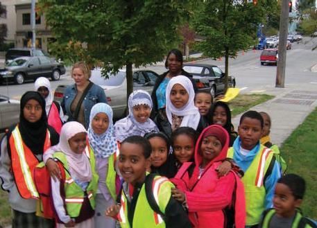
5 Safe Routes to School Activities Currently, there isn t a targeted Safe Routes to School program at, but there are estimated to be more than 150 students that regularly walk or bike to school. Due to the size of the attendance area, the largest percentage of students are either driven or take a bus to and from school. Students walking home from school along Pine Street (top photo) and south of the school towards Prairie Street (bottom photo). Safe Routes to School Comprehensive Plan P a g e 4

6 Students waiting to cross at the TH 55/Pine Street signal. In-classroom tallies of students arrival and departure modes were conducted at in October As shown in the chart on the following page, an average of 10 percent of students currently walk to school and an average of 4 percent of students currently bike to school. The tallies also showed that almost double the number of students walked home from school in the afternoon, compared to the morning, which is a typical pattern for many elementary and middle schools. Safe Routes to School Comprehensive Plan P a g e 5


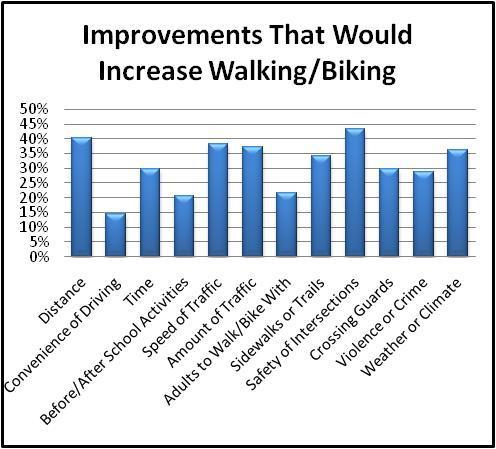
7 A parent survey of concerns and attitudes related to walking and biking was also conducted in October and November 2010, with approximately 110 responses. About 30 percent of the respondents reported that they live less than 1 mile from school and about 60 percent said they live less than 2 miles from school, which is consistent with the data provided by the Hastings Bus Company. About 37 percent of parents said their child had asked for permission to walk or bike to school in the last year, compared with only 15 to 20 percent that said their child normally walks or bikes to school. Distance and weather were the key factors that parents cited as influencing their decision to allow students to walk or bike, Safe Routes to School Comprehensive Plan P a g e 6


8 followed by intersection safety and speed/amount of traffic. The charts below and on the following page show some of the key results from the survey. A sample of the parent comments from the survey is also included in the Appendix. Safe Routes to School Comprehensive Plan P a g e 7

9 Safe Routes to School Comprehensive Plan P a g e 8


10 Infrastructure The primary access to the site is on 11 th Street via Pine Street. The parking lot between and Pinecrest Elementary is primarily used by the middle school for staff, as well as parents and visitors. There is also an overflow parking lot west of the main parking lot, but it is unused on normal school days. View of 11 th Street entering the middle school site. There are two one-way driving lanes, which expand to three lanes at the drop-off/pick-up area. View of Pinecrest Elementary from the parking lot. Safe Routes to School Comprehensive Plan P a g e 9
11 The collector and arterial roadways surrounding the school generally have a good system of sidewalks and trails, but not all local streets have sidewalk. Sidewalk was planned to be constructed on Lyn Way between 15 th Street and the TH 55 South Frontage Road as part of the 2010 street reconstruction project, but the sidewalk construction was removed from the project based on opposition from the adjacent property owners. The lack of sidewalk on the west side of Pine Street, north of TH 55, is due to a similar situation when Pine Street was reconstructed several years ago. Within the City of Hastings, construction of new sidewalk is assessed to the adjacent property owners and clearing of ice and snow is also the responsibility of the property owner. The City of Hastings Parks and Recreation Department is currently in the planning phases for a 1.2-mile trail connection on the north side of County Road 46/47 between Pleasant Drive and the Vermillion River. The trail is projected to be constructed in 2011 using city and county funding sources, as well as a Department of Natural Resources (DNR) grant. The major roadway crossings around the school are TH 55 (18,800 vehicles/day), Pine Street (5,700 vehicles per day), and 15 th Street (6,300 vehicles per day). There are signalized crossings of TH 55 at River Street and Pine Street, signalized crossings of TH 61 at TH 55 and 15 th Street, and all-way stop control at the Pine Street/15 th Street intersection. The signalized intersections have pedestrian indications on all approaches where crossings are allowed. The pedestrian crossing times are all based on a 7-second walk time and flashing don t walk (clearance) times of seconds for the minor street and seconds for the major street. These times are based on an average 4 feet/second walking speed and should be adequate for students to cross the roadway, as long as the push button is used. The other key pedestrian/bicycle crossings are signed as school crossings and have marked crosswalks. The crossing at Pine Street/11 th Street also has paid adult crossing guards during the morning arrival period. There are advance warning flashers for the school crossings on Pine Street that are operated during the school day. There is also a school speed zone on Pine Street between 10 th Street and 13 th Street that lowers the speed limit from 30 miles miles per hour (mph) to 20 mph when children are present. The City of Hastings does not have a traffic calming policy, but has experimented with various measures in the past. The city would not conisder speed bumps on local city streets and speed bumps are not allowed on any municipal state aid streets, per state aid requirements. Safe Routes to School Comprehensive Plan P a g e 10


12 Advance warning flashers and school crossing signing on northbound Pine Street. Most of the available bike parking at is in a visible location adjacent to the main entrance on the south side of the school. There are also two bike racks on the north side of the school. Well-used bike racks at. Safe Routes to School Comprehensive Plan P a g e 11
13 A review of the crash history for the past ten years ( ) was completed for the area around the school bounded by Pleasant Drive, 2 nd Street, TH 61 and Southview Drive. The crashes in the period from January 1999-June 2001 were evaluated based on the location of the middle school at that time and that analysis area was expanded to include the area east of TH 61 to the Mississippi River. There have been a number of pedestrian and bicycle crashes, which are generally summarized as follows: Type: o 60 total pedestrian and bike crashes o 25 crashes 1999-June 2001 / 35 crashes July o Slightly more bike crashes (57%) than pedestrian crashes (43%) Location: o 21 crashes occurred on TH 61 o 17 crashes occurred on TH 55 o 13 crashes occurred on 15 th Street o 8 crashes occurred on Pine Street o The locations with the most crashes were TH 61/15 th Street (7 crashes) and TH 55/Pleasant Drive (5 crashes) o The Pine Street/15 th Street intersection has been identified as a concern. There have been 2 pedestrian crashes at this location, both of which occurred on a weekday between 2:30 and 4:30 pm and involved a child that was middle school age (11-14 years old). In one crash, the vehicle was listed as at fault and in the other crash the pedestrian was listed as being at fault. o There have been no pedestrian/bike crashes at River Street/15 th Street or River Street/14 th Street. o In 1999 there were 5 crashes that occurred on a weekday afternoon during the school year, were located on TH 55 or TH 61 within 5 blocks of the middle school, and involved middle school age children. All the crashes involved right-turning vehicles that failed to yield to the pedestrian. o In 2003 a bike crash involving a student biking to at 7:40 am occurred adjacent to Pinecrest Elementary School (12 th Street west of Pine Street) occurred at 7:40 am. Pedestrian/Bicyclist Characteristics: o 10% of crashes involved a child less than 11 years old (elementary age) o 30% of crashes involved a child years old (middle school age) o 12% of the crashes involved a child years old (high school age) o The remaining 48% of crashes involved an adult pedestrian or bicyclist Safe Routes to School Comprehensive Plan P a g e 12
 on a weekday during the school year and involved an 11-14 year old child (middle school age).")
14 Time of Day: o Only 1 crash occurred between 7 AM and 9 AM (before the middle and elementary school start times) on a weekday during the school year o 10% of the crashes occurred between 2 PM and 6 PM (after school) on a weekday during the school year and involved an year old child (middle school age). The larger number of crashes in the afternoon is likely related to the larger number of students that walk or bike home in the afternoon. In addition to the pedestrian/bicycle crash history, the vehicle crash history at the Pine Street/11 th Street and Pine Street/12 th Street intersections were reviewed for the time period of July 2001 through During that time, there was only one reported crash that occurred at Pine Street/11 th Street between 7 AM and 8 AM or 2 PM and 6 PM on a weekday during the school year. At the Pine Street/12 th Street intersection, there was one reported rear-end crash at 7:30 AM and two crashes between 2 PM and 3 PM on a weekday during the school year. Site Evaluation A site evaluation was completed at in October and November 2010 that included walking around the site and observing the typical arrival and dismissal processes. At the middle school, all buses enter and exit the site using the TH 55 South Frontage Road. There are approximately 22 buses on the site, which means the north parking lot is underutilized during both arrival and dismissal. An estimated 20 to 50 parent vehicles use the bus parking lot for pick-up and drop-off to avoid the congestion in the designated pick-up/drop-off areas on the south side of the school. Buses in the north parking lot at waiting for afternoon dismissal. Safe Routes to School Comprehensive Plan P a g e 13

15 Pick-up and drop-off traffic all enter the school site from 11 th Street (one way westbound) and exit on 12 th Street (one way eastbound). Parents drop off students directly in from the school in the morning and pick up students in the south parking lot and along both sides of the driveway in the afternoon. This generates numerous mid-block crossings and pedestrians stepping into the roadway from between parked vehicles. Parents also are encouraged to use the overflow lot at the southwest corner of the school, but only one vehicle was observed picking up a student there. Vehicles also use the parking lot drive aisle between and Pinecrest Elementary School for parking and pick-up, as well as a shortcut to exit the site. This also causes vehicle/vehicle and vehicle/pedestrian conflicts. Queue of vehicles during morning drop-off at. is currently in the process of a reorganization and transition process that will result in all 5 th grade students being moved to the middle school starting in school year. In addition, the three elementary schools will be converted from grades 1-5 to grades K-4, and the Tilden Kindergarten Center will be closed. These changes also may include changes in the start and end times of some or all of the schools. As part of this process, a Transportation and Safety Task Force has been established for that is charged with developing recommendations that will go to the Middle School Program Task Force for consideration, along with the recommendations of other task forces. The Transportation and Safety Task Force is currently discussing many building and site issues, including location of main entrances, building security, configuration and use of parking areas, location of bus loading/unloading, location of parent pick-up/drop-off, and staff parking. Safe Routes to School Comprehensive Plan P a g e 14

.")
16 Queues of parent vehicles on the school site waiting for the middle school dismissal. Parked vehicles and student pick-up along the parking lot between and Pinecrest Elementary. The observed primary pedestrian routes to and from the middle school are on Pine Street, Prairie Street, and River Street (north/south) and 11 th Street and 12 th Street (east/west). While no significant conflicts were observed at the designated school crossings, several mid-block crossings were observed after Safe Routes to School Comprehensive Plan P a g e 15

17 school along TH 55. About 40 bikes were counted in the bike racks at during the October observation and 25 bikes were counted in the November observation. Existing Issues and Challenges Students crossing TH 55 east of the Pine Street signalized intersection. In addition to the data collection and site evaluation completed as part of this project, input was gathered from the school principal, the Transportation and Safety Task Force, Hastings Bus Company, the City of Hastings, and Mn/DOT. The existing challenges to walking and biking to are summarized in the following bullets, as well as the map following this section: The walk boundary is large, but includes some areas with few pedestrian or bike facilities. The large size of the attendance area results in many students living outside the walk area. Some roadways within the walk area lack sidewalk or trail, which results in students being driven to school or walking in the street. The school has a relatively early start time (7:45 am) and many after school activities, so students walk/bike to and from school in the dark during winter. Safe Routes to School Comprehensive Plan P a g e 16
18 There is a history of pedestrian/bicycle crashes in the walk area around the school, 30 percent of which involved year old children (middle school age). TH 55, TH 61, TH 316, County Road 46/47, and County Road 42 are barriers to walking and biking due to the roadway width, vehicle volumes, and vehicle speeds. The pedestrian crossing of TH 55 at Roadside Park is a safety concern for the larger community, not just students walking and biking to school. Starting in the fall of 2011, there will be 5 th grade students at, which means younger pedestrians walking and biking to and potentially more students being driven to school. Recommendations Despite some of the current challenges to walking and biking to, the school s location within the city of Hastings and the size of the student population does provide opportunities to increase the numbers of students regularly walking and biking to school. The following recommendations have been developed specifically for to address the identified challenges to walking and biking. The short-term recommendations are actions that could be implemented during the school year, while the long-term recommendations may require policy changes, additional discussion and coordination, or significant funding sources. In addition to the recommendations, the group that should take the lead in implementing the recommendation has also been identified. Since the transition process is on-going and the findings and recommendations of the Transportation and Safety Task Force need to be integrated and consistent with the planning for the middle school site, no recommendations regarding the site have been included in this plan. However, the existing data and site evaluations have been shared with the Task Force for their consideration and incorporation into their plans and recommendations. Short-Term Recommendations The short-term recommendations included in this section primarily consist of low-cost improvements that can be implemented in the next six months, although some are dependent on funding availability. The recommendations are generally prioritized in terms of actions that are easiest or most necessary to complete first. The infrastructure recommendations are also summarized on the Recommendations map included at the end of this report. Safe Routes to School Comprehensive Plan P a g e 17

19 1. The Pine Street/11 th Street intersection is a key pedestrian crossing location that also has significant traffic volumes entering the school site. should continue to maintain adult crossing guards at this location to facilitate safe pedestrian crossings into the site. Implementation lead. Adult crossing guards at the 11 th Street/Pine Street intersection during morning arrival at. 2. Establish a permanent Safe Routes committee for the Hastings Public School District to provide on-going support and organization for Safe Routes activities. Implementation lead Hastings School District. 3. The new federal Manual on Uniform Traffic Control Devices (MUTCD) changed the assumed walking speed for signalized pedestrian crossings from 4.0 feet/second to 3.5 feet/second. As a result, the flashing don t walk (flashing upraised hand) times at all signalized intersections with pedestrians crossings will need to be increased to the new standard. Mn/DOT plans to make these changes starting in Implementation lead Mn/DOT. 4. Increase the visibility of the school crossing signing at the Pine Street/11 th Street intersection by trimming the tree branches in front of the sign on northbound Pine Street. Implementation lead City of Hastings. Safe Routes to School Comprehensive Plan P a g e 18

20 View of school crossing signing on northbound Pine Street at 11 th Street. 5. Consider changes to the operation of the advance warning flashers on Pine Street to be active only at the times when students would be crossing, rather than all day. The flashers may also be considered for removal based on lack of effectiveness. Implementation lead City of Hastings. 6. Prairie Street and 14 th Street are included in the City of Hastings Infrastructure Improvements Program in The existing crosswalks at Prairie Street/14 th Street are faded and there is a sidewalk gap on Prairie Street between 14 th Street and 15 th Street. The appropriate crossing treatment (if any) for the Prairie Street/14 th Street intersection and a potential sidewalk connection on Prairie Street will need to be studied as part of the reconstruction planning process, consistent with current city policies for crosswalks and sidewalk. Implementation lead City of Hastings. Safe Routes to School Comprehensive Plan P a g e 19

21 Existing school crossing on 14 th Street at Prairie Street (top photo). End of the trail connection from to Prairie Street, looking north (bottom photo). 7. Create information for parents and students that communicates the benefits of walking and biking to school, as well as tips on walking and biking safely. Students should be directed to always crossing major roadways at intersections with traffic signals, such as TH 55/River Street, TH 55/Pleasant Drive, and TH 61/15 th Street. Implementation lead. Safe Routes to School Comprehensive Plan P a g e 20

22 8. Start a weekly or monthly Walk to School Day with incentives for students that walk and bike, such as water bottles, gift cards, or getting out of class early. Implementation lead. Long-Term Recommendations The long-term recommendations included in this section primarily consist of higher cost improvements or actions that would require a significant policy change, either of which would be expected to take longer than six months to occur. These recommendations are generally prioritized in order of importance, however funding availability may mean that the highest priority recommendations are not the first to be implemented. The infrastructure recommendations are also summarized on the Recommendations map included at the end of this report. 1. Conduct a bike/walk mapping project for, which could be done as a student project, by a school district Safe Routes committee, or by the Transportation and Safety Task Force. Information is collected from maps, from agency staff such as city engineering and police departments, and from students about available and preferred routes to and from school. Based on the data, maps of the routes to and from school are developed, as well as other key locations such as libraries, police stations, or other schools. Implementation lead. Example of a school walk/bike route map. Source: Minneapolis Public Schools. Safe Routes to School Comprehensive Plan P a g e 21
 and do not include countdown timers. Implementation lead Mn/DOT.")
23 2. Upgrade pedestrian indications at the TH 55/TH 61 and TH 55/Pine Street intersections when the traffic signals are improved or replaced. The existing indications contain word messages (WALK/DON T WALK) and do not include countdown timers. Implementation lead Mn/DOT. Existing pedestrian indications at the TH 55/Pine Street (top photo) and TH 55/TH 61 (bottom photo) intersections. Safe Routes to School Comprehensive Plan P a g e 22

24 3. The River Street/15 th Street intersection was identified by, parents, and the Transportation Task Force as an intersection of concern. The River Street/15 th Street intersection does not meet warrants for all-way stop control, and therefore no control changes are recommended at the intersection. The City of Hastings will need to study the appropriate crossing treatment (if any) at the intersection, consistent with its policies, as part of a roadway reconstruction project planned to occur within the next few years. Implementation lead City of Hastings. Existing school crossing signing on 15 th Street at Prairie Street. 4. Consider adding walking and bicycling curriculum to physical education classes and a bicycle repair shop as an after school club. Implementation lead Hastings Middle School/Hastings School District. 5. Continue to pursue opportunities for construction of new sidewalk and trail segments to better connect to the sidewalk and trail system. Sidewalk and trail construction could be completed in coordination with adjacent roadway projects or as independent projects. Implementation lead City of Hastings. 6. Install additional bike racks when the capacity of the existing racks is reached. Implementation lead /Hastings School District. Safe Routes to School Comprehensive Plan P a g e 23
25 7. If wishes to pursue a school speed zone on TH 55, the school should first discuss the zone with the City of Hastings and then with the Mn/DOT Area Engineer. School speed zones must be established by the road authority, which in this case would be Mn/DOT. Implementation lead request to City of Hastings and Mn/DOT; if speed zone is warranted and approved, installation responsibility would be Mn/DOT and enforcement responsibility would be City of Hastings. 8. As part of roadway or other projects on TH 55, measures such as landscaping should be considered to discourage mid-block crossings. Implementation lead Mn/DOT 9. Install pedestrian/bicycle wayfinding signing through the middle school/elementary school campus to provide better connectivity to the rest of the community and sidewalk/trail network. Implementation lead Hastings School District. Funding and Implementation Funding for the various recommended projects may come from a variety of sources depending on the type of project and who is implementing it. Some potential funding opportunities that currently exist and may be used to fund these recommendations include, but are not limited to: Statewide Health Improvement Program funds, which are available through several programs administered by Dakota County Public Health: o Safe Routes to School grants o Active Living grants, which are available to cities in Dakota County, but may be used to fund improvements off school sites o Assistance with preparation of infrastructure grant applications. Cities in Dakota County can submit infrastructure projects and the County s consultant will assist in identifying potential funding sources and preparing applications. Blue Cross Blue Shield of Minnesota Mini-grants through the National Center for Safe Routes to School Federal Transportation Enhancement (TE) funds through the Metropolitan Council Federal Safe Routes to School funds through the Minnesota Department of Transportation. The federal Safe Routes to School program was originally funded through fiscal year 2009, but Mn/DOT is expected to have another grant solicitation in spring Future funding will be dependent on passage of the Federal Surface Safe Routes to School Comprehensive Plan P a g e 24
26 Transportation Reauthorization Bill, which is still being discussed in the United States Congress. Increased liability of the school, school district, or adult volunteers as a result of encouraging walking and biking to school is a frequent concern when implementing Safe Routes to School programs. In general, encouraging walking and biking to school does not increase the liability of the school or the district. Some tips and guidelines from the National Center for Safe Routes and the Public Health Law Center are included in the appendix of this report as a reference. Links to additional resources such as an overall Safe Routes to School guide, walking school bus guide, and safety education materials are also provided in the appendix. No one of the E s of Safe Routes to School will by itself increase walking and biking, which emphasizes the need for cooperation among school, city, county and other agencies. The process used to develop this plan is only the start of on-going efforts that will be needed to result in cultural changes and significant increases in walking and biking. Safe Routes to School Comprehensive Plan P a g e 25
27 PARK LN LYN WAY N ST LOUIS LN D LN ANOR LN OAK ST FRAISE FOREST ST ASHLAND ST PLEASANT DR FARM ASH ST OLIVE STATE ST GRO 2ND ST W nm TILDEN ELEMENTARY PINE ST 3RD ST W FOREST ST 1ST S RD 18,800VEHICLES/DAY (2008) è!! 55 LIONS PARK 2,800 VEHICLES/DAY (2007) SIDEWALK GAP! è!!! è!!! SOUTH FRONTAGE RD 5TH ST W PRAIRIE ST RIVER ST 7TH ST W MAPLE ST 6TH ST W 8TH ST W R LILAC CIR HILLSIDE ST HILLSIDE ST VIEW CT HILLSIDE CT BAHLS DR 6,300 VEHICLES/DAY (2007) 1,350 VEHICLES/DAY (2007) SIDEWALK/TRAIL GAP CONZEMIUS PARK ÅÆÇ OVERFLOW PARKING 14TH ST W!"$ ZWEBER LN BUS LOADING/ UNLOADING 3-LANE DRIVES - SPEEDING CONCERNS TRAIL GAP ÅÆÇ nm "½ "½ 8w 123 FGHW ÅÆÇ HASTINGS MIDDLE SCHOOL!"$ SIDEWALK GAP PARENT PICK-UP/DROP-OFF STAFF PARKING nm FGHX PINECREST ELEMENTARY kj ÅÆÇ ËÌ 123 ^_ ÅÆÇ ÅÆÇ ËÌ 123 FGHW kj ÅÆÇ!"$ 5,700 VEHICLES/DAY (2007) 10TH ST W PIONEER PARK 55 STUDENT CROSS TH 55 MIDBLOCK 11TH ST W 12TH ST W 15TH ST W WALNUT ST 1239 ROADSIDE PARK 8w 9TH 13T 16TH ST W WESTVIEW DR LEGEND kj 89:w ÅÆÇ ^_ nm "½ KEY PEDESTRIAN CROSSING FLASHER SCHOOL CROSSING CROSSWALK SCHOOL PATROL LOCATION SIDEWALKS MUTLI-USE TRAILS ON-SITE SIDEWALK ON-SITE MULTI-USE TRAIL PUBLIC SCHOOL BICYCLE RACKS NOTE: SIDEWALKS SHOWN ON MAJOR ROUTES ONLY FOR CLARITY HASTINGS COUNTRY CLUB SOUTHWEST PONDING BASIN MANOR CT 19TH ST W 18TH ST W 17TH ST W Feet HASTINGS MIDDLE SCHOOL EXISTING CONDITIONS/ISSUES
28 PARK LN LYN WAY N ST LOUIS LN D LN ANOR LN OAK ST FRAISE FOREST ST PLEASANT DR FARM ASH ST OLIVE STATE ST 1 - UPDATE PEDESTRIAN CROSSING TIMES TO NEW MUTCD STANDARDS 2 - TRIM TREE TO INCREASE CROSSING VISIBILITY 3 - MODIFY FLASHER OPERATIONS TO TIMES WHEN STUDENTS ARE PRESENT 4 - STUDY APPROPRIATE CROSSING TREATMENTS IN CONJUNCTION WITH CITY PROJECTS nm 5 - PURSUE OPPORTUNITIES TO FILL SIDEWALK/TRAIL GAPS 6 - CONSIDER MEDIAN TREATMENTS TO DETER MID-BLOCK CROSSINGS 5TH ST W R RD LILAC CIR HILLSIDE ST HILLSIDE ST è!! 55 LIONS PARK! è!!! è!!! VIEW CT HILLSIDE CT BAHLS DR CONZEMIUS PARK 5 14TH ST W!"$ ZWEBER LN PRAIRIE ST ÅÆÇ nm "½ "½ 8w 123 FGHW ÅÆÇ 5 HASTINGS MIDDLE SCHOOL!"$ nm 5 FGHX PINECREST ELEMENTARY 5 6 kj ÅÆÇ ËÌ 123 ^_ ÅÆÇ ÅÆÇ ËÌ 123 kj ÅÆÇ!"$ 7TH ST W PIONEER PARK 6 10TH ST W 55 11TH ST W 12TH ST W 15TH ST W 6TH ST W WALNUT ST 1239 ROADSIDE PARK 8TH ST W 8w 9TH 13T 16TH ST W WESTVIEW DR LEGEND kj 89:w ÅÆÇ ^_ nm "½ FLASHER SCHOOL CROSSING CROSSWALK SCHOOL PATROL LOCATION SIDEWALKS MUTLI-USE TRAILS ON-SITE SIDEWALK ON-SITE MULTI-USE TRAIL PUBLIC SCHOOL BICYCLE RACKS NOTE: SIDEWALKS SHOWN ON MAJOR ROUTES ONLY FOR CLARITY HASTINGS COUNTRY CLUB SOUTHWEST PONDING BASIN MANOR CT 19TH ST W 18TH ST W 17TH ST W Feet HASTINGS MIDDLE SCHOOL RECOMMNEDATIONS
29 Appendix
30 Parent Survey Comments My children would have to cross both 316 and 61 so biking really wouldn't be feasible. As it is, they walk a couple of blocks after getting off the bus. I don't really care for that as there are no sidewalks and they have to walk in the street. I have been lucky enough to be able to adjust my schedule so I can give my child as well as some other neighbor kids a ride in the morning. Along the way I see others walking in the dark and cold. Some even riding their bikes down the middle of the street. I think it's only a matter of time before someone is injured. Most drivers are watching out for kids, but there are always a few rushing to get somewhere that scare me. I would love to see free bus rides for the middle schools. The kids are starting at a younger age all the time and should not be walking in the dark or early morning hours. I realize they can be dropped off early and go sit in the cafeteria. I know my own child and his friends would rather walk or bike so they didn't have to do that. My child needs to cross Hwy 55 to get to school, that's a problem. We have a crosswalk close to our house but I don't even feel comfortable using it because no one ever stops. I would allow my son to bike the distance to school, if he did not have to travel along (and cross) Highway 47. If there were a safe bike route developed, he would like to bike and I would let him. I have never been comfortable with my child walking across Highway 55, however there is no other viable option for her to get home from school. I think a walking bridge should be installed across Hwy 55 at either Pine or River Streets. I would prefer she walk further to have a safer route across Hwy 55. My child has been riding his bike to and from school since 6th grade. The only thing that I have a problem with is there are no crossing guards at 15th and Pine before school and after school. My daughter will be attending the middle school for 5th grade and will have to ride or walk to school as we don t really want to have to pay for her to ride the bus. Would love to see crossing guards at 15th and Pine. She would have to cross a major intersection and unfortunately no one had children in mind when designing the neighborhoods as there are very few sidewalks. My concern is the safety of dropping and picking kids up in front of the school. It is so dangerous. Parents are pulling out in front of other cars and into the walk ways while there are pedestrians. I would love it if my kids rode their bikes to school or walked in a group. I do not feel that it is safe with two major highways to cross. And the bar that men are standing outside freaks them out. We live too far from the school to allow my child to walk to school. I pay for bus service because it is too far for my son to walk in the winter. My child already has to walk to school and has been harassed and threatened by older kids after school. Also, weather is a huge concern for me and it would be nice to have an option for him to ride the bus when it s 40 below. Safe Routes to School Comprehensive Plan
31 Each child is different. There are some children that I would allow to bike at 5th grade and others may never bike to school. It all depends on the child that you are talking about. It is very difficult to draw a line in the sand at what age is appropriate to ride or walk to school. My son was attacked walking home by other kids - I do not ever recommend it. My child rode his bike to and from school during the summer when busing was not available. I would sincerely hope no parent allows their child to walk/bike to school alone before middle school unless they are within a 2 block radius. If someone were able to 100% assure that my daughter would not be harassed or assaulted along the way, I would let her ride her bike to school... and if her backpack was lighter! My daughter and I often rode our bikes to McAulliffe during good weather. The distance and lack of supervision would make riding her bike or walking without me out of the question. I usually drop him off in the AM at SEAS. He rides the bus to the middle school and then home. Walks but we still have concerns about crossing Hwy 55! We live in the country. Our kids would/could walk to school if we lived closer. My children both enjoy(ed) biking to school, but weather is a factor much of the school year. Since there is no activity bus available, they do walk or bike home after sports if a ride is unavailable. Walking time is approx 30 min, so it sometimes would run into evening activities. I would love for our kids to bike or walk to school but we live way too far out. I think busing should be free for over 1.5 miles away from school. We are considered walkers because we live close to the high school even though she goes to the middle school. I can t believe they expect 6th graders and maybe even a 5th grader to walk across General Sieben Dr and Hwy 55 before 7am in the dark to catch a bus to the middle school in the morning! Safety is a major concern that early, weather and traffic! Safe Routes to School Comprehensive Plan

32 National Center for Safe Routes to School Safe Routes to School Programs and Liability Tip Sheet For 10 Tips SafeRoutes Background and Overview Forty years ago, nearly 90 percent of children who lived close to their school walked or bicycled to get there. Today, this number has decreased by about 25 percent.1 As Safe Routes to School (SRTS) programs have developed to reverse this trend, some have wondered if encouraging walking and bicycling to school may increase a school s liability exposure. In general, the answer is no. In fact, SRTS programs are designed to help schools and communities identify and address potential safety concerns. Taking concrete steps to make walking and bicycling safer will reduce the likelihood of injury, and thereby minimize exposure to liability. A SRTS program that simply encourages or promotes bicycling and walking to school should not, in most cases, expose schools to increased liability risk. Even school-sponsored walking and bicycling programs, such as a Walking School Bus or Bicycle Train should not expose schools to any greater liability than other school-sponsored activities. Of course, schools with SRTS programs must ensure they are meeting their responsibilities for children s safety just as they must routinely do with all other forms of school transportation and with other school activities. SRTS programs can vary greatly, ranging from programs to encourage walking and bicycling to active sponsorship of walking and bicycling programs and providing new infrastructure to support these activities. The school s responsibility for safety will vary according to the individual elements of the SRTS program and the local legal context. The information below provides a brief overview of the relevant legal definitions and identifies several issues you may want to look into as you develop your program to ensure you are addressing any potential liability issues. This information is not intended as legal advice and should not be used as such. For specific legal guidance, you should consult with an attorney with relevant knowledge and experience. Legal Context Schools and school districts must regularly address issues of liability for a variety of school programs and school sponsored activities. Regardless of whether students walk, bike, take the bus, or are driven to school, there is a possibility that an injury may occur on or off school property. However, not all injuries result in liability. The extent to which a school will be held legally responsible or liable for its negligent actions or omissions depends on the facts of a given case, on laws and legal principles that vary from state to state, and even from school district to school district. In general, to establish liability for negligence, the injured person or someone acting on his or her behalf must show that the school owed a legal duty of care to that person, that the school breached that duty, and that the breach was the proximate cause of damages or injury.2 (Visit Law.com and search liability and negligence for more detailed definitions and descriptions.)

33 10 Tips Safe Routes to School Programs and Liability (continued) For A school s duty of care to students and resulting legal liability when students are injured is very situational and can only be assessed in the context of the specific program or activity and with knowledge of the specific facts giving rise to an injury. Relevant factors are likely to include: the degree to which the school controls or directs the activity that results in injury, the extent to which the school s actions conformed to applicable rules, regulations, policies, or procedures, and the extent to which the school knew or should have known of a particular hazard and failed to correct or warn against it. A school will not ordinarily be held liable for injuries sustained by children while they are walking or bicycling to school simply because the school encourages children to walk or bike, where injuries occur off school property, and parents have been reminded that the school is not responsible for supervising children who walk or bike to school. To avoid liability for negligence, the school must exercise reasonable care under the circumstances. If the school directly sponsors walking or bicycling activities such as a Walking School Bus or Bike Train, the school generally has greater responsibilities just as they would for other schoolsponsored forms of transportation. At a minimum, the school should follow the recommended procedures outlined in the National Center for SRTS publication, The Walking School Bus: Combining Safety, Fun and the Walk to School ( index.cfm) as well as any rules, policies, or protocols established by the school district for school-sponsored activities occurring off school property. (For example, volunteer training, screening, or adult to child ratios.) Minimizing Risk Even though SRTS programs are designed to make walking and bicycling safer for students, there are certain steps the school should take to minimize the risk that the school will be held liable for negligence in the event that a student is hurt while walking or bicycling to school. Some key measures are detailed below. References 1. In 1969, 87 percent of children 5 to 18 years of age who lived within one mile of school walked or bicycled to school. In 2001, 63 percent of children 5 to 18 years of age who lived within one mile of school walked or bicycled to school. U.S. Centers for Disease Control and Prevention. Kids Walk-to-School: Then and Now Barrier and Solutions. Available: Accessed: January 17, Schools Legal Service, Orange County Department of Education School Districts and School District Employees Liability for Negligence. Costa Mesa, CA.

34 10 Tips Safe Routes to School Programs and Liability (continued) For 1 the Work with your school district s administrative and legal staff to understand relevant liability issues and to develop appropriate policies. Most likely, your school district already has a number of policies in place to help manage its liability for various school programs and activities. A SRTS program is no different. You should work closely with your school district s administrative and legal staff to identify any particular risk management and insurance needs based on your individual SRTS program and the relevant laws of your jurisdiction. 2 If Be aware of local laws, regulations, and school policies. Work with your school s legal counsel to identify the laws and regulations in your jurisdiction that are relevant to walking and bicycling. These may include laws regarding school safety patrols, the designation of school walking routes (some states require them), student bus transportation, and any bicycle safety requirements such as helmets, bells or lights. You should also review the state and local pedestrian laws and portions of the local development code regarding pedestrian safety and provision of pedestrian accommodations. Make sure you are following any applicable school policies, such as parental permission slips, waivers, or required supervision for school-sponsored activities. If appropriate, your school may consider making modifications or exceptions to any school policies that appear to be in conflict with your SRTS activities. 3 4 Develop Take steps to fix problems. you are aware of unsafe walking and bicycling conditions, such as unsafe vehicle drop off and pick up conditions, take steps to fix them. Even if the problem is not subject to the school s control, such as a heavily trafficked local street, the school should warn parents of any known hazards, and take any prudent steps to address conditions under the school s control that might exacerbate the risk of injury. Be proactive. a plan. Developing a SRTS Plan for an individual school is a great way to identify potential safety problems and prioritize needed improvements. If you identify problems, take steps to address the problems and inform the school community of possible hazards that cannot be or have not yet been corrected. 5 Document your efforts. If you are aware of potential problems, document your efforts to fix them. For example, if you are made aware of problems with speeding vehicles in the school area, keep records of your communication with law enforcement officials to address the problem and your communications to parents warning them of any uncorrected problems.
35 10 Tips Safe Routes to School Programs and Liability (continued) For 6 Parents 8 Be uniform, systematic and consistent in undertaking safety improvements. In making improvements such as new sidewalks or improved crossings, follow accepted engineering and design practices. Any design exceptions should be carefully reviewed so as not to compromise safety. Consider waivers. Where a SRTS program sponsors specific transportation activities, such as a walking school bus or bicycle train, a school may decide to require parent volunteers and parents of student participants to sign waivers or permission slips acknowledging that the participants are assuming the risk of injury by engaging in walking and bicycling activities, and waiving any claims against the school for its negligent acts or omissions. Keep in mind that waivers need to be carefully drafted in order to be effective. 7 Inform and involve parents. and designated caretakers are ultimately responsible for deciding how their children get to school. Material promoting SRTS programs should make clear that parents should determine their child s readiness and the best route for walking and bicycling. Encourage parents to accompany younger children. Let parents know the location of signalized or marked crossings and locations with crossing guards and recommend that they use them. Provide pedestrian and bicycle safety tips to parents as well as students. (See safety tip sheets at the National Center s Web site at resources/education_tip-sheets.cfm) 9 Make Obtain adequate insurance coverage for your program. Your school district is likely to have a large umbrella policy that covers a range of school programs and school sponsored activities. Review this policy to ensure the SRTS activities you are organizing are covered. If they are not, have the policy adjusted to include these activities. 10 Provide training. sure crossing guards and school employees working on traffic and safety issues are well trained regarding pedestrian and bicycle safety and their responsibilities for ensuring that children are safe on their journey to and from school. Provide training to volunteers, and if appropriate, screening, where volunteers will be supervising children as part of a SRTS activity, such as a formal Walking School Bus or Bike Train. SafeRoutes National Center for Safe Routes to School For more resources and information on Safe Routes to School, please visit the National Center for Safe Routes to School Web site at


36 ` LIABILITY FOR VOLUNTEERS IN THE WALKING SCHOOL BUS PROGRAM A Walking School Bus Program aims to get children walking to and from school in groups accompanied by adults. It encourages students and adults to be more physically active and social. The program is ideal for neighborhoods that have a school within walking distance. Adult volunteers are essential to the Walking School Bus Program. They are responsible for organizing the program and for walking the children to and from school. Adult volunteers are expected to act responsibly just as they would with their own children. Provided that adult volunteers act reasonably and with good intention, a Minnesota statute will protect them from liability claims for accidents that occur during the course of volunteering. Q: What is liability? A: Put simply, liability is a legal responsibility. Typically, for you to be held liable, someone must prove that: You owed them a duty of care; You failed to perform that duty or did so negligently; and Your negligence caused someone harm that could have reasonably been expected to occur. Q: What is a person s duty of care? A: The duty you owe someone depends on the circumstances. Generally, everyone has the duty to act with reasonable care toward others. What is considered reasonable also depends on the circumstances. Q: What is negligence? A: Negligence is the failure to act as carefully as an ordinary, reasonable person would in the same situation. Q: What is cause of harm? A: Cause of harm means that your action was an important factor in causing the harm and that you could have reasonably expected the injury to occur. Q: Are there any Minnesota laws that provide added protection to volunteers? A: Yes. Under a Minnesota law, volunteers will generally not be liable for a child s injuries if their actions (1) were in good faith, (2) within the scope of their duties, and (3) not willful or reckless.

37 Q: What does acting in good faith mean? A: This means acting with a good, honest intention or belief. Good Faith: A volunteer takes the children down a different route one day, believing the traffic will be lighter. The traffic is actually heavier, and a car hits a child while he is crossing the road in a crosswalk. Not Good Faith: A child misbehaves during the walk. The volunteer makes the child walk home by himself, knowing that the child does not know the way home. The child gets lost and is injured. Q: What does acting within the scope of their duties mean? A: This means acting according to one s role or responsibilities as a volunteer. Within the Scope of Duties: A student slips and is injured while the volunteer is walking the student to school. Not Within Scope of Duties: After school, a student stays over at a volunteer s house to play with the volunteer s children. The student slips and is injured. Q: What is willful or reckless conduct? A: This means acting with disregard for the safety of others, or failing to act with ordinary care to prevent or discover a danger. Some examples of willful or reckless conduct might include: telling a child to run across the street when the light is red; telling children to cross the road without looking both ways; or making children walk long distances in extreme heat without water. Q: If I am sued, will insurance cover the costs of the litigation? A: Check the terms of your homeowner s or renter s insurance policy to learn what is covered. Typically, insurance consists of two parts property coverage and personal liability coverage. The personal liability portion of the policy may protect against a lawsuit brought by someone who is injured by something you do. It will pay for damages or medical expenses if you are responsible for the injury. Also, it will pay for legal expenses to defend you if the lawsuit is unjustified. Q: How can Walking School Bus Program volunteers reduce the risk of liability? A: Common sense precautions go a long way toward avoiding liability risk. Most importantly, a parent volunteer should act like an ordinary, reasonable person. Additional steps could be: Creating safety rules and handing them out to all students and parents. These safety rules should comply with any local school rules. Planning a training day for students and volunteers. Wearing fluorescent vests while walking with the children. Asking the parents or guardians to sign a waiver saying they will not hold you liable for any injuries. (Please refer to the Public Health Law Center s Waivers and Releases Fact Sheet.) Eliminating dangers, where possible. Having one adult volunteer for every six children over the age of 10 and one adult volunteer per three children for four to six year-olds. Documenting all precautions taken to avoid harm or risk. For related publications, visit Click on Publications and Resources link and then on Fact Sheets. The Public Health Law Center provides information and technical assistance on issues related to tobacco and public health. The Public Health Law Center does not provide legal representation or advice. This document should not be considered legal advice. For specific legal questions, consult with an attorney. Contact the Public Health Law Center for citations used in this factsheet. Updated July 2010.

 practitioners get these students excited about Safe Routes to School?")
38 Tips FOR Engaging Middle School Students in Safe Routes to School Programs SafeRoutes National Center for Safe Routes to School Tip Sheet Middle school students are very energetic and curious and yet engaging them can be a challenge. They have a new level of independence when it comes to walking and bicycling to school compared to when they were younger, but may be reluctant to take advantage of it because they think it uncool. They may also resist walking and bicycling safety advice from adults. How can Safe Routes to School (SRTS) practitioners get these students excited about Safe Routes to School? The secret lies in recognizing and building off of the typical attributes of middle school students: A desire for self-expression and self-determination A preference for hands-on learning that is personally relevant An expanding awareness of social, cultural, and environmental issues A growing concern for peer approval A sense of awkwardness and self-consciousness associated with the onset of puberty The following tips offer ways to use these attributes to engage students in a Safe Routes program. In most cases, these ideas require coordination with the school, so it is a good idea to discuss options with administrators and teachers before getting started. Students at Hall Middle School in Marin County, California prepare to take the stage for a school assembly on the benefits of green transportation that they helped plan. Tip 1 Provide opportunities for self-expression and self-determination. Ask students to design logos, posters, computer animations, and web sites with SRTS messages. Put students in charge of planning SRTS-related activities, such as assemblies, fundraisers and publicity campaigns. Tip 2 Create hands-on learning experiences that are personally relevant. Ask students to identify locations where changes like sidewalks or crossing guards would improve walking conditions using GPS devices, digital cameras or checklists for assessing walkability and bikeability. Middle school students use portable computers, digital cameras, and GPS devices to identify blighted properties and other safety concerns around their schools as part of the Mapping Out a Safer Community Program in Detroit, Michigan. Establish a build-a-bike program, where students can learn about bicycle repair, maintenance, and safety by fixing up used or donated bikes, which they then get to keep. Encourage students to voice their need for improved walking and biking conditions. Suggest a presentation at a public meeting or a letter writing campaign to local decision-makers.

39 Tips For Engaging Middle School Students in Safe Routes to School Programs (continued) Tip 3 Highlight the connection between SRTS and social, cultural, or environmental issues that may be important to students. Organize lessons, activities, and events about climate change and the benefits of walking or bicycling for transportation. Invite local sports personalities to talk about how walking and biking to school promotes physical fitness and health. Tip 4 Foster positive interactions between middle school students and their peers and provide opportunities for peer identification and acceptance. Start a club with a mission that ties into SRTS, such an after-school bicycling or environmental club. Plan events that emphasize fun but also deliver relevant SRTS messages, such as a Walk to School Day or Walk and Roll Day celebrating walking and biking to school. Develop a cross-age teaching program, where older students teach bicycle and pedestrian safety skills to younger students. High-school students can be recruited to teach middle school students and middle school students might decide to teach elementary school kids. Alexandria, Virginia s Junior Bicycle Ambassadors demonstrate a turn signal during a Bicycle Rodeo at Hammond Middle School. Tip 5 Be sensitive to the vulnerability, awkwardness, and self-consciousness that often accompany the middle school years. Avoid putting middle school students in situations where they may be exposed to ridicule or embarrassment, such as contests that identify losers on an individual basis or where students are allowed to choose teams. Be extremely sensitive when addressing the issue of obesity. SafeRoutes National Center for Safe Routes to School For more resources and information on Safe Routes to School, please visit the National Center for Safe Routes to School Web site at


40 Safe Routes to School guide saferoutesinfo.org


41


42 SafeRoutes National Center for Safe Routes to School

43
Safe Routes to School Comprehensive Plan
 Safe Routes to School Comprehensive Plan City of Apple Valley Dakota County, MN May 2010 Prepared by: Project Background The Statewide Health Improvement Program (SHIP) aims to help Minnesotans live longer,
Safe Routes to School Comprehensive Plan
 Safe Routes to School Comprehensive Plan City of Rosemount Dakota County, MN June 2010 Prepared by: Project Background The Statewide Health Improvement Program (SHIP) aims to help Minnesotans live longer,
Safe Routes to School Comprehensive Plan
 Safe Routes to School Comprehensive Plan City of South St. Paul Dakota County, MN December 2010 Prepared by: Project Background The Statewide Health Improvement Program (SHIP) aims to help Minnesotans
Safe Routes to School Comprehensive Plan
 Safe Routes to School Comprehensive Plan City of Rosemount Dakota County, MN June 2010 Prepared by: Project Background The Statewide Health Improvement Program (SHIP) aims to help Minnesotans live longer,
July 5, Arthur R. Ware, Jr. Elementary School 2017 Safe Routes to School Walkabout Report
 July 5, 2017 Arthur R. Ware, Jr. Elementary School 2017 Safe Routes to School Walkabout Report 1 Walkabout Report Introduction On April 28, 2017, City, School, and SAWMPO staff met to conduct a Safe Routes
SAFE ROUTES TO SCHOOL
 SAFE ROUTES TO SCHOOL Edgewood Elementary School Existing Conditions and ACTION PLAN > Oak Creek - Franklin Joint School District Table of Contents CONTEXT Enrollment Boundaries Enrollment
SAFE ROUTES TO SCHOOL
 SAFE ROUTES TO SCHOOL Forest Ridge Elementary School Existing Conditions and ACTION PLAN > Oak Creek - Franklin Joint School District Table of Contents CONTEXT Enrollment Boundaries
Bringing together community and health. Physical Activity and Nutrition Unit Office of Statewide Health Improvement Initiatives
 Bringing together community and health. Physical Activity and Nutrition Unit Office of Statewide Health Improvement Initiatives Physical Activity and Nutrition Unit Office of Statewide Health Improvement
Drag and drop pic and stretch/crop to the limits of the blue rectangle (delete this text box) Maxey Elementary School
 Maxey Elementary School") Drag and drop pic and stretch/crop to the limits of the blue rectangle (delete this text box) Maxey Elementary School SCHOOL ROUTE PLAN For MAXEY ELEMENTARY SCHOOL LOCATION 33 ORANGE COUNTY Prepared for:
Drag and drop pic and stretch/crop to the limits of the blue rectangle (delete this text box) Maxey Elementary School SCHOOL ROUTE PLAN For MAXEY ELEMENTARY SCHOOL LOCATION 33 ORANGE COUNTY Prepared for:
Vallecito Elementary School. Travel Plan
 Vallecito Elementary School Travel Plan TABLE OF CONTENTS 1. PURPOSE... 1 1.1. SR2S PLANNING, IMPLEMENTATION AND MONITORING... 1 1.2. MARIN COUNTY MEASURE A... 1 2. VALLECITO ELEMENTARY SCHOOL PROFILE...
CITY OF OAK CREEK SAFE ROUTES TO SCHOOL ACTION PLAN. East Middle School
 CITY OF OAK CREEK SAFE ROUTES TO SCHOOL ACTION PLAN East Middle School CITY OF OAK CREEK SAFE ROUTES TO SCHOOL ACTION PLAN East Middle School Why Safe Routes to School? Safe Routes to School ( SRTS ) is
Chapter 2. Bellingham Bicycle Master Plan Chapter 2: Policies and Actions
 Chapter 2 Bellingham Bicycle Master Plan Chapter 2: Policies and Actions Chapter 2: Policies and Actions The Bicycle Master Plan provides a road map for making bicycling in Bellingham a viable transportation
S A F E R O U T E S T O S C H O O L H E R M A N TOW N S C H O O L S A N D P R O C TO R S C H O O L S P L A N A P P R OVA L S
 S A F E R O U T E S T O S C H O O L H E R M A N TOW N S C H O O L S A N D P R O C TO R S C H O O L S P L A N A P P R OVA L S WHAT IS SAFE ROUTES TO SCHOOL? In 1969, nearly 50% of children walked or rode
Hennepin County Bicycle and Pedestrian Planning
 Hennepin County Bicycle and Pedestrian Planning 1 Value of bicycle and sidewalk systems Safety Livability Mobility Health Personal Finances Economic Sustainability Clean Air Recreation Parking and congestion
Agenda. Overview PRINCE GEORGE S PLAZA METRO AREA PEDESTRIAN PLAN
 PRINCE GEORGE S PLAZA METRO AREA PEDESTRIAN PLAN May 28, 2008 Agenda Welcome and introductions Project overview and issue identification Planning context and strengths Design challenges and initial recommendations
EXECUTIVE SUMMARY. Vision
 Vision Walking and bicycling in Salt Lake City will be safe, convenient, comfortable, and viable transportation options that connect people to places, foster recreational and economic development opportunities,
Hidden Oaks Elementary School
 Hidden Oaks Elementary School SCHOOL ROUTE PLAN For HIDDEN OAKS ELEMENTARY SCHOOL LOCATION 13 ORANGE COUNTY Prepared for: ORANGE COUNTY SCHOOL ASSESSMENT PROGRAM ORANGE COUNTY PUBLIC WORKS Traffic Engineering
Meadow Woods Elementary School
 Drag and drop pic and stretch/crop to the limits of the blue rectangle (delete this text box) Meadow Woods Elementary School Drag and drop pic and stretch/crop to the limits of the blue rectangle (delete
Safe Routes to School Guide
 Safe Routes to School Guide Steps to Creating a Safe Routes to School Program Created February 2007 SafeRoutes National Center for Safe Routes to School This guide was developed by the Pedestrian and Bicycle
Sebastopol Charter School Traffic Management Plan
 Sebastopol Charter School The serves as the working document in support of these essential goals: to ensure the safety and efficiency of student arrival to and departure from school to ensure the safety
5. RUNNINGWAY GUIDELINES
 5. RUNNINGWAY GUIDELINES These guidelines should be considered collectively when making runningway decisions. A runningway is the linear component of the transit system that forms the right-of-way reserved
CITY MANUALS AND STANDARDS REVIEW
 GEORGETOWN SIDEWALK MASTER PLAN CITY MANUALS AND STANDARDS REVIEW RESOURCES AND STANDARDS As part of the Master Plan process, a review and evaluation of current City documents and policies relevant to
City of Novi Non-Motorized Master Plan 2011 Executive Summary
 City of Novi Non-Motorized Master Plan 2011 Executive Summary Prepared by: February 28, 2011 Why Plan? Encouraging healthy, active lifestyles through pathway and sidewalk connectivity has been a focus
NEIGHBORHOOD TRAFFIC CALMING POLICY
 NEIGHBORHOOD TRAFFIC CALMING POLICY I. PURPOSE The City of Kent continually strives to strengthen and protect its neighborhoods by improving the quality of life in residential areas. Traffic conditions
Lake Whitney Elementary School
 Lake Whitney Elementary School SCHOOL ROUTE PLAN For LAKE WHITNEY ELEMENTARY SCHOOL LOCATION 18 ORANGE COUNTY Prepared for: ORANGE COUNTY SCHOOL ASSESSMENT PROGRAM ORANGE COUNTY PUBLIC WORKS Traffic Engineering
Draft North Industrial Area-Wide Traffic Plan
 Summary of North Industrial and Hudson Bay Industrial Recommended Improvements Table 1. Summary of s Item Location 1 2 3 4 5 6 7 8 9 10 11 12 Millar Ave north of 51st St Super 8 Motel back lane 400 Block
Madison Urban Area and Dane County. Bicycle Transportation Plan Summary. September Introduction. Bicycle Plan Scope and Planning Process
 Bicycle Transportation Plan Summary Madison Urban Area and Dane County Introduction September 2000 Bicycling is an important mode of transportation in the Madison urban area and countywide that is available
CITY OF KASSON TRANSPORTATION ALTERNATIVES KASSON SAFE ROUTES TO SCHOOL
 ve ha 8t G B A Mantorville Ave N 240th Ave 16th St NE 11th Ave NE K-M HIGH SCHOOL SUNRISE TRAIL TO MANTORVILLE MNTH 57 SUNSET TRAIL TO MANTORVILLE NE PARK 16TH ST NE TRAIL K-M ELEMENTARY SCHOOL K-M MIDDLE
C/CAG. Sunnybrae Elementary School Walking and Bicycling Audit. San Mateo-Foster City School District JUNE 2013
 Sunnybrae Elementary School Walking and Bicycling Audit JUNE 2013 San Mateo-Foster City School District C/CAG City/County Association of Governments of San Mateo County SUNNYBRAE ELEMENTARY SCHOOL WALKING
Monroe Street Reconstruction
 Total participants: 45+ Monroe Street Reconstruction Cross Section Workshop Notes September 29, 2016, Wingra School Workshop Orientation, Technical and Functional Considerations: The workshop began with
TOWN OF PORTLAND, CONNECTICUT COMPLETE STREETS POLICY
 TOWN OF PORTLAND, CONNECTICUT COMPLETE STREETS POLICY I. VISION, GOALS & PRINCIPLES VISION To improve the streets of Portland making them safer and more accessible for all users including pedestrians,
City of Albert Lea Policy and Procedure Manual 4.10 ALBERT LEA CROSSWALK POLICY
 4.10 ALBERT LEA CROSSWALK POLICY PURPOSE: Pedestrian crosswalks are an integral part of our transportation infrastructure. To be effective and promote safety, marked crosswalks must be installed after
CITY OF BLOOMINGTON COMPLETE STREETS POLICY
 CITY OF BLOOMINGTON COMPLETE STREETS POLICY POLICY OBJECTIVE: The City of Bloomington will enhance safety, mobility, accessibility and convenience for transportation network users of all ages and abilities,
Double the amount of bicycle ridership while at the same time reducing the number of bicycle crashes by one-third.
 CHAPTER 6 Recommended Policies and Action Items To achieve the goals stated in Chapter 1 and guide implementation of the Bicycle Plan, policies and action items have been identified. They are presented
Prioritizing Schools for Safe Routes to School Infrastructure Projects
 Prioritizing Schools for Safe Routes to School Infrastructure Projects Determining the most effective use of limited infrastructure funds is a challenging task. It is especially demanding for local transportation
BIKE PLAN CONTENTS GATEWAY
 CONTENTS Acknowledgments...vii Great Rivers Greenway District Board of Directors... vii Great Rivers Greenway District Staff... vii Project Consultants... vii Committees... viii Citizens Advisory Committee
CITY OF WEST KELOWNA COUNCIL POLICY MANUAL
 CITY OF WEST KELOWNA COUNCIL POLICY MANUAL Page 1 of 7 DEPARTMENT: Engineering Services SUBJECT: Traffic Calming Policy (Revised June 6, 2017) Policy Statement: The provision of traffic calming measures
Solana Beach Comprehensive Active Transportation Strategy (CATS)
") Solana Beach Comprehensive Active Transportation Strategy (CATS) 3.0 Goals & Policies The Solana Beach CATS goals and objectives outlined below were largely drawn from the Solana Beach Circulation Element
Solana Beach Comprehensive Active Transportation Strategy (CATS) 3.0 Goals & Policies The Solana Beach CATS goals and objectives outlined below were largely drawn from the Solana Beach Circulation Element
AGENDA. 5. Next Steps a. Survey Distribution b. Draft Action Plan/Recommendations c. Review at next meeting in advance of document preparation
 Congdon Elementary Safe Routes to School Plan Update SRTS Team Meeting #2-Walk Audit March 21, 2018, 3:00 p.m. Congdon Elementary School Art Room-Duluth, MN 1. Welcome and Introductions 2. SRTS Review
City of Wayzata Comprehensive Plan 2030 Transportation Chapter: Appendix A
 A1. Functional Classification Table A-1 illustrates the Metropolitan Council s detailed criteria established for the functional classification of roadways within the Twin Cities Metropolitan Area. Table
Chapter 5. Complete Streets and Walkable Communities.
 Chapter 5. Complete Streets and Walkable Communities. 5.1 Description of Complete Streets. Cities throughout the world, and specifically the United States, are coming to embrace a new transportation and
Safe Routes to School Travel Plan 2011
 Safe Routes to School Travel Plan 2011 Barley Sheaf Elementary School Barley Sheaf School 80 Barley Sheaf Road Flemington, NJ 08822 Grades: K-4 Introduction Barley Sheaf School is a K-4 elementary school
Arlington Public Schools Thomas Jefferson Site Evaluation Transportation Networks. Thomas Jefferson Working Group Meeting #6 November 10, 2014
 Arlington Public Schools Thomas Jefferson Site Evaluation Transportation Networks Thomas Jefferson Working Group Meeting #6 November 10, 2014 2 3 INTRODUCTION 4 Goal of our work: Identify and assess multi-modal
Randolph-Hamline ( Ran-Ham ) Area Safe Routes to School Plan
 Area Safe Routes to School Plan") Randolph-Hamline ( Ran-Ham ) Area Safe Routes to School Plan Cretin Derham Hall Expo Elementary Holy Spirit Elementary Randolph Heights Elementary Saint Paul, Minnesota September 2016 Prepared By: Saint
Randolph-Hamline ( Ran-Ham ) Area Safe Routes to School Plan Cretin Derham Hall Expo Elementary Holy Spirit Elementary Randolph Heights Elementary Saint Paul, Minnesota September 2016 Prepared By: Saint
About the Studio. Edward J. Bloustein School of Planning and Public Policy - Rutgers University
 About the Studio Edward J. Bloustein School of Planning and Public Policy - Rutgers University Purpose of studio: Help City of Bayonne apply for Safe Routes to School (SRTS) funding by producing a School
Why Zone In on Speed Reduction?
 Learn it. Do it. Live it! SPEED REDUCTION IN THE ZONE Why Zone In on Speed Reduction? Speeding is a serious issue that plays a major role in the risk of serious injury and pedestrian fatality in a crash.
Chapter 2: Standards for Access, Non-Motorized, and Transit
 Standards for Access, Non-Motorized, and Transit Chapter 2: Standards for Access, Non-Motorized, and Transit The Washtenaw County Access Management Plan was developed based on the analysis of existing
Glenn Avenue Corridor Traffic Operational Evaluation
 Glenn Avenue Corridor Traffic Operational Evaluation PREPARED FOR: THE CITY OF AUBURN PREPARED BY: DECEMBER 2007 Glenn Avenue Corridor Study--Auburn, Alabama TABLE OF CONTENTS Introduction... 1 Background
Parent Survey Report: One School in One Data Collection Period
 Parent Survey Report: One School in One Data Collection Period School Name: Broken Arrow Elementary School Set ID: 12172 School Group: Douglas County Month and Year Collected: October 2014 School Enrollment:
Chapter VISION, MISSION, AND GOALS AND OBJECTIVES. Vision. Mission. Goals and Objectives CONNECTING COMMUNITIES ACROSS THE ST.
 VISION, MISSION, AND GOALS AND OBJECTIVES Chapter 3 The Plan s vision, mission, and goals and objectives were developed through a series of interactive exercises with the Citizens Advisory Committee (CAC)
This page intentionally left blank.
 This page intentionally left blank. COMMUNITY Coweta Community Overview Coweta Coweta, a residential community located in Wagoner County, is a suburb of Tulsa situated southeast of the metropolitan area
MARKET/JFK VISION ZERO PILOT PROJECT FEBRUARY 2019 EVALUATION REPORT
 MARKET/JFK VISION ZERO PILOT PROJECT FEBRUARY 2019 EVALUATION REPORT WHY IS THIS PROJECT IMPORTANT? Market Street and JFK Boulevard in Center City are key east-west corridors in the core business district.
Traffic Impact Memorandum. May 22, 2018
 BISHOP PROFESSIONAL DEVELOPMENT BUILDING Proposed Land-use Change & Parking Modification 3601 SW 31st Street Topeka, Kansas 66614 CFS Project No. 185077 Traffic Impact Memorandum May 22, 2018 Prepared
The Corporation of the City of Sarnia. School Crossing Guard Warrant Policy
 The Corporation of the City of Sarnia School Crossing Guard Warrant Policy Table of Contents Overview And Description... 2 Role of the School Crossing Guard... 2 Definition of a Designated School Crossing...
DRAFT. Table of Contents. Background
 Douglas County Table of Contents Existing Infrastructure 86 Funding 89 Policy and Program Recommendations 90 Infrastructure Recommendations 92 Conclusion 95 Background Home to 4,500 residents and Baker
Orange Center Elementary School
 Drag and drop pic and stretch/crop to the limits of the blue rectangle (delete this text box) Orange Center Elementary School Drag and drop pic and stretch/crop to the limits of the blue rectangle (delete
Project Update May 2018
 Project Update May 2018 Dakota County, in cooperation with the City of Lakeville, is planning to reconstruct 202 nd Street West (County Road 50) from Holyoke Avenue to Cedar Avenue (County Road 23). 202
TOWN OF CHAPEL HILL POLICY AND PROCEDURES FOR TRAFFIC CALMING MEASURES
 TOWN OF CHAPEL HILL POLICY AND PROCEDURES FOR TRAFFIC CALMING MEASURES (Adopted by the Town Council on June 30, 2004) (Revised December 6, 2010) (Revised February 8, 2016) POLICY AND PROCEDURES FOR TRAFFIC
City of Ann Arbor Pedestrian Safety & Access Task Force
 City of Ann Arbor Pedestrian Safety & Access Task Force (PSATF) Community Wide Meeting Wednesday, July 8th 6:30 to 8:30 PM Multi purpose Room, Downtown Library www.a2gov.org/pedsafety The Greenway Collaborative,
NM-POLICY 1: Improve service levels, participation, and options for non-motorized transportation modes throughout the County.
 Transportation PRINCE WILLIAM COUNTY 2008 COMPREHENSIVE PLAN NON-MOTORIZED PLAN CONTENTS Goals, Policies, and Action Strategies Table 4 (Bike Facility Classifications and Descriptions) Table 5 (Bike Facility
Active Transportation Facility Glossary
 Active Transportation Facility Glossary This document defines different active transportation facilities and suggests appropriate corridor types. Click on a facility type to jump to its definition. Bike
TRAFFIC CALMING GUIDE FOR TORONTO CITY OF TORONTO TRANSPORTATION SERVICES DIVISION
 TRAFFIC CALMING GUIDE FOR TORONTO CITY OF TORONTO TRANSPORTATION SERVICES DIVISION CITY OF TORONTO TRANSPORTATION SERVICES DIVISION 2016 TRAFFIC CALMING GUIDE FOR TORONTO TABLE OF CONTENTS Introduction
Bicycle Master Plan Goals, Strategies, and Policies
 Bicycle Master Plan Goals, Strategies, and Policies Mobilizing 5 This chapter outlines the overarching goals, action statements, and action items Long Beach will take in order to achieve its vision of
Corpus Christi Metropolitan Transportation Plan Fiscal Year Introduction:
 Introduction: The Safe, Accountable, Flexible, Efficient Transportation Equity Act: A Legacy for Users (SAFETEA-LU) has continued the efforts started through the Intermodal Surface Transportation Efficiency
Non-Motorized Transportation 7-1
 Non-Motorized Transportation 7-1 Transportation facilities no longer mean just accommodating a vehicle powered by a combustion engine. Pedestrian and non-motorized facilities are important modes of travel
Caltrans Sloat Boulevard Pedestrian Safety Project Response to Community Questions, Comments & Concerns
 Caltrans Sloat Boulevard Pedestrian Safety Project Response to Community Questions, Comments & Concerns Revised: May 10, 2016 The California Department of Transportation (Caltrans) is planning various
POLICY: TRAFFIC CALMING
 2006 MAY REFERENCE: COUNCIL APPROVED BY COUNCIL MAY 23, 2006 CITY OPERATIONS - NO. 608 POLICY: TRAFFIC CALMING A. All requests for traffic calming within the City shall be considered in accordance with
Appendix A: Crosswalk Policy
 Appendix A: Crosswalk Policy Appendix A: Crosswalk Policy Introduction This citywide Crosswalk Policy is aimed at improving pedestrian safety and enhancing pedestrian mobility by providing a framework
TOWN OF PAYSON TRAFFIC CALMING MANUAL
 TOWN OF PAYSON TRAFFIC CALMING MANUAL APPROVED BY THE PAYSON TOWN COUNCIL SEPTEMBER 6, 2007 TOWN OF PAYSON TRAFFIC CALMING POLICY 1.0 Introduction Traffic Calming involves retrofitting physical devices
Living Streets Policy
 Living Streets Policy Introduction Living streets balance the needs of motorists, bicyclists, pedestrians and transit riders in ways that promote safety and convenience, enhance community identity, create
APPENDIX A: Complete Streets Checklist DRAFT NOVEMBER 2016
 APPENDIX A: Complete Streets Checklist DRAFT NOVEMBER 2016 Complete Streets Checklist MetroPlan Orlando s Complete Streets Checklist is an internal planning tool for staff to further implementation of
Chapter 3.3 Horizon Elementary School. Volusia County MPO. June 2009
 Chapter 3.3 Horizon Elementary School Port Orange, FL Volusia County MPO June 2009 Volusia County MPO School Bicycle and Pedestrian Review Study, Phase 3C School Summary Horizon Elementary School is located
This page intentionally left blank.
 This page intentionally left blank. COMMUNITY Glenpool Community Overview Glenpool Glenpool is a city of nearly 12,000 residents located in Tulsa County southwest of Tulsa and Jenks. The city is growing
TRAFFIC ACTION PLAN. North Central Neighborhood CITY OF SAN MATEO
 TRAFFIC ACTION PLAN North Central Neighborhood CITY OF SAN MATEO Draft February 2017 Table of Contents Introduction... 1 The Traffic Forum Process... 4 Neighborhood Traffic Issues... 6 Neighborhood Recommendations
CITY OF SAINT JOHN TRAFFIC CALMING POLICY
 CITY OF SAINT JOHN TRAFFIC CALMING POLICY VERSION: 1.0 April 10, 2012 Pedestrians, Cyclists and Motorists Sharing Street Spaces CONTENTS INTRODUCTION... 3 POLICY GOAL... 3 POLICY OBJECTIVES... 3 GUIDING
COWETA HIGH SCHOOL AND EAST HIGHWAY 51
 COWETA HIGH SCHOOL AND EAST HIGHWAY 51 Lack of sidewalks along Ben Lumpkin Rd. Lack of crosswalks and ramps at intersection. Hwy 51 is wide to cross as a pedestrian. No ADA compliance or connection to
PRINCE GEORGE S PLAZA METRO AREA PEDESTRIAN PLAN
 PRINCE GEORGE S PLAZA METRO AREA PEDESTRIAN PLAN May 28, 2008 Agenda Welcome and introductions Project overview and issue identification Planning context and strengths Design challenges and initial recommendations
TRAFFIC STUDY. Birch Bluff Road / Pleasant Avenue 01/15/2018. City of Tonka Bay 4901 Manitou Road Tonka Bay, MN WSB PROJECT NO.
 TRAFFIC STUDY Birch Bluff Road / Pleasant Avenue 01/15/2018 City of Tonka Bay 4901 Manitou Road Tonka Bay, MN 55331 WSB PROJECT NO. 10805-000 Birch Bluff Road/ Pleasant Avenue Traffic Study For: City of
Wellington Exempted Village School District SAFE ROUTES TO SCHOOL TRAVEL PLAN January 2014
 Wellington Exempted Village School District SAFE ROUTES TO SCHOOL TRAVEL PLAN January 2014 OHIO SAFE ROUTES TO SCHOOL WELLINGTON EXEMPTED VILLAGE SCHOOL DISTRICT TRAVEL PLAN SECTION 1: WELLINGTON EXEMPTED
Aitkin School Routing Plan July 2010
 Aitkin School Routing Plan July 2010 Prepared by: Arrowhead Regional Development Commission Regional Planning Division Aitkin School Routing Plan July 2010 Aitkin School Routing Plan July 2010 Prepared
Windom Area Schools District #177 Safe Routes to School Plan Winfair Elementary & the Middle School January 2014
 Windom Area Schools District #177 Safe Routes to School Plan Winfair Elementary & the Middle School January 2014 Prepared by: Southwest Regional Development Commission 2401 Broadway Avenue, Suite 1 Slayton,
SECTION 1 - CONTACT INFORMATION
 SECTION 1 - CONTACT INFORMATION Please complete the information below. The person identified as the Project Contact Person will be the primary point of contact for Georgia DOT staff. Organization: (Please
3 Silverton High School Report
 3 Silverton High School Report Principal: Justin Lieuallen Grades: 9-12 Enrollment: 1,277 Address: 1456 Pine Street First bell: 7:55 a.m. Silverton, OR 97381 Last bell: 3:05 p.m. Free & Reduced Lunch:
Project Goal and Description. Why Broadway? Broadway SFMTA.COM/BROADWAY. The goal of the Broadway Safety Improvement
 PROJECT OVERVIEW Project Goal and Description The goal of the Broadway Safety Improvement d St Van Ness Ave Project is to improve safety and comfort for all who Franklin St Hyde St Octavia St Gough St
Parent Survey Report: One School in One Data Collection Period
 Parent Survey Report: One School in One Data Collection Period School Name: Pinckney Elementary School Set ID: 12170 School Group: Douglas County Month and Year Collected: October 2014 School Enrollment:
TRAFFIC IMPACT ANALYSIS
 TRAFFIC IMPACT ANALYSIS FOR THE CHAMPAIGN UNIT#4 SCHOOL DISTRICT PROPOSED HIGH SCHOOL (SPALDING PARK SITE) IN THE CITY OF CHAMPAIGN Final Report Champaign Urbana Urbanized Area Transportation Study 6/24/2014
Implementing the Three Es of School Zone Traffic Calming
 Implementing the Three Es of School Zone Traffic Calming Use this evaluation tool as a guide to analyze the specific safety needs of your school. SCHOOL PROFILE School Name: School District: Address: Phone
Pedestrian Road Safety Audit
 Pedestrian Road Safety Audit Middlebrook Road From Father Hurley Boulevard to Waring Station Road December 2017 Montgomery County Department of Transportation Table of Contents 1. Introduction... 1 1.1
The Florida Bicycle and Pedestrian Partnership Council
 The Florida Bicycle and Pedestrian Partnership Council Input to the Update of the Florida Transportation Plan March 2015 This document presents input from the Florida Bicycle and Pedestrian Advisory Council
ADA Transition Plan. City of Gainesville FY19-FY28. Date: November 5, Prepared by: City Of Gainesville Department of Mobility
 ADA Transition Plan FY19-FY28 Date: November 5, 2018 Prepared by: City Of Gainesville Department of Mobility 1.0 INTRODUCTION 1.1 BACKGROUND The federal statute known as the Americans with Disabilities
Table of Contents Introduction. 2 Purpose of the Plan...2 The Benefits of Walking and Bicycling...3 Vision and Goals of the Plan...
 BICYCLE AND This plan was created through a grant from the Healthy Communities Program with the cooperation of the City of Cynthiana, Cynthiana Main Street, Cynthiana-Harrison County-Berry Joint Planning
CITY OF VISTA TRAFFIC CALMING PROGRAM
 CITY OF VISTA TRAFFIC CALMING PROGRAM The purpose of the Vista Traffic Calming Program is to reduce speeds of motorists driving through residential neighborhoods. The program does not apply to nonresidential
DEPARTMENT OF ENVIRONMENTAL SERVICES. North Harrison Street (Lee Highway to Little Falls Road) Comparative Analysis. Prepared for:
 Comparative Analysis. Prepared for:") DEPARTMENT OF ENVIRONMENTAL SERVICES North Harrison Street (Lee Highway to Little Falls Road) Comparative Analysis Prepared for: Arlington County Department of Environmental Services 2100 Clarendon Boulevard,
DEPARTMENT OF ENVIRONMENTAL SERVICES North Harrison Street (Lee Highway to Little Falls Road) Comparative Analysis Prepared for: Arlington County Department of Environmental Services 2100 Clarendon Boulevard,
OCEAN DRIVE ELEMENTARY SCHOOL
 OCEAN DRIVE ELEMENTARY SCHOOL North Myrtle Beach, SC Safe Routes to School Travel Plan JANUARY 2017 SRTS Team Roster SRTS Team members represent key community stakeholders, share work of developing the
Traffic Circulation & Pedestrian Safety Study
 Lyons Township High School North Campus La Grange, Illinois Parking Lot Vaughan Building N Main Building Prepared for: Prepared by: July 23, 2015 Contents List of Figures, iii 1. Introduction...1 2. Existing
ACTIVE TRANSPORTATION
 ACTIVE TRANSPORTATION Mobility 2040 Supported Goals Improve the availability of transportation options for people and goods. Support travel efficiency measures and system enhancements targeted at congestion
TABLE OF CONTENTS. Executive Summary
 Executive Summary Background... ES-1 Pedestrian Network... ES-2 Bikeway Network... ES-2 Collision History... ES-2 Public Input... ES-4 Conclusions and Recommendations... ES-4 1. Introduction and Setting
SRTS Programs That Increase Walking and Bicycling to School
 Getting Results: SRTS Programs That Increase Walking and Bicycling to School SafeRoutes National Center for Safe Routes to School Communities initiate Safe Routes to School (SRTS) programs for a variety
Summary Report School Walking & Bicycling Audits. Mesa County Regional Transportation Planning Office
 Summary Report School Walking & Bicycling Audits Mesa County Regional Transportation Planning Office This page left blank intentionally WALKING & BICYCLING AUDIT SUMMARY 2 Executive Summary Background:
o n - m o t o r i z e d transportation is an overlooked element that can greatly enhance the overall quality of life for the community s residents.
 N o n - m o t o r i z e d transportation is an overlooked element that can greatly enhance the overall quality of life for the community s residents. 84 Transportation CHAPTER 11 INTRODUCTION Transportation