Safe Routes to School Comprehensive Plan
|
|
|
- Horace Berry
- 6 years ago
- Views:
Transcription


1 Safe Routes to School Comprehensive Plan City of South St. Paul Dakota County, MN December 2010 Prepared by:
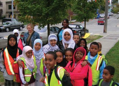
2 Project Background The Statewide Health Improvement Program (SHIP) aims to help Minnesotans live longer, healthier lives by reducing the burden of chronic disease. The Dakota County Public Health Department received SHIP funding to work with community partners to develop and implement programs to improve nutrition, increase physical activity, and reduce tobacco use in schools, workplaces, community settings, and healthcare sites. As part of this effort, comprehensive Safe Routes to School (SRTS) plans have been developed for 17 schools in Dakota County that seek to increase walking and biking to school through the following means: Education Teaching children to walk and bike safely. Encouragement Developing programs that get children excited about walking or biking to school, such as walk/bike incentive programs or Walk to School Day. May also include methods that help parents and guardians feel comfortable letting their child walk or bike, such as walking school buses or adult crossing guards. Enforcement Having law enforcement support, such as speed zone enforcement or increased patrols, along the designated routes to school. Engineering Identifying infrastructure barriers to walking and biking, such as sidewalk/trail gaps, hazardous crossings, or the need for secure bicycle parking. Evaluation Measuring the effectiveness of the various components of the SRTS project. The following sections describe the development of a Safe Routes to School Plan for Lincoln Center Elementary in the City of South St. Paul, Dakota County, Minnesota. Existing Conditions is part of Special School District 6, which encompasses the city of South St. Paul in the Twin Cities suburbs. Lincoln Center encompasses about 2.5 city blocks and is bounded by 3rd Street N, 9 th Avenue, 4th Street N, and 12 th Avenue. The school is located near South St. Paul Middle and High School (Secondary Building) and the remaining area surrounding the school is primarily residential. Student Data Currently, there are approximately 950 students in kindergarten through 6 th grade at Lincoln Center Elementary ( school year) and the school day is from 8:15 am to 3:00 pm. Safe Routes to School Comprehensive Plan P a g e 1
3 The attendance area for Lincoln Center primarily includes the areas north of Southview Boulevard (County Road 14) within the city limits. The walk area is approximately 1.5 miles and there is only a small area at the northern end of the attendance area that has free district-provided bus transportation. The walk area for Lincoln Center Elementary, as well as student distribution data provided by the South St. Paul School District, is shown on the map on the following page. Students at Lincoln Center that bike to school are required to abide by the following rules: Wear a bicycle helmet Follow the directions of school patrols and walk bikes at patrolled intersections Walk the bicycle when on school property Have a bicycle identification number (BIN) label on the bike s stem (obtained at school) and properly lock the bike in one of the furnished racks. Complete a bike safety course. Safe Routes to School Activities Lincoln Center Elementary patrols 6 intersections around the school with 5 th and 6 th grade crossing guards. Currently, there isn t a targeted Safe Routes to School program at the school, but the school did receive a grant to hold a walk/bike day in the spring of In addition, a Saturday bicycle education program for all ages has been held in the spring and fall, with the course painted at Lincoln Center. An estimated 300 students live in the attendance area outside the walk area, and therefore are provided bus transportation, or live outside the city (open enrollment) but are not provided bus transportation. The remaining 600+ students live within the 1.5-mile walk area and therefore are not provided bus transportation. However, only about 20 percent of these students in the walk area regularly walk or bike to and from school. This results in a very large volume of pick-up and drop-off vehicle traffic around the school in the morning and afternoon. In-classroom tallies of students arrival and departure modes were conducted at Lincoln Elementary during October As shown in the chart below, an average of 20 percent of students currently walk to school and an average of 1 percent of students currently bike to school. The most predominant mode is family vehicle, resulting in very large numbers of parent vehicles during pick-up and drop-off. Most of the students that travel to/from school in a family vehicle live within the designated walk area. The tallies also showed that slightly more students walked and rode the bus home from school in the afternoon. The students that live in the walk area, particularly north of Southview Boulevard (County Road 14) and east of 15 th Avenue, would be the targeted audience to regularly walk or bike to school. Safe Routes to School Comprehensive Plan P a g e 2


4 17TH AVE N 1ST AVE S STAR LN 23RD AVE N 21ST AVE N CAMBER AVE ORCHARD LN 20TH AVE N 20TH AVE N 18TH AVE N HOLLAND AVE 17TH AVE N 9TH AVE N BUTLER AVE CONVER AVE SUMMIT CT 52 WILDE AVE KAPOSIA PARK LANE ST PLEASANT AVE 16TH AVE N HAWLEY AVE 15TH AVE N SUMMIT PARK SUMMIT AVE TERRACE LN èëì 52 THOMPSON AVE RAMP èëì 24TH AVE N BURMA LN JEWELL LN FLORANCE LN GILBERT LN 89:w ÅÆÇ ^_ SOUTHVIEW BLVD nm CT 22ND AVE S 22ND AVE N WENTWORTH AVE CAROLINE LN ISALONA LN HANSEN LN HEIMEL ST KRAFT ST LEGEND 23RD AVE S FRANCIS ST UPPER 45TH ST E LIBERTY PL ACORN LN DESSA LN BROMLEY ST THOMPSON AVE EARL LN VINE ST 21ST AVE N 21ST AVE N 21ST AVE S 2ND ST S 62% OF STUDENT POPULATION FROM WITHIN THE CITY BUT OUTSIDE THE STUDY AREA CRESTHAVEN DR SCHOOL CROSSING CROSSWALK 21ST AVE S LOGAN LN 20TH AVE N SOUTHVIEW PARK NORTHVIEW PARK 19TH AVE N REID LN 3RD ST N EVA LN 20TH AVE S SCHOOL PATROL LOCATION SIDEWALKS MUTLI-USE TRAILS MISSING SIDEWALK CITY BOUNDARY WALK AREA 2ND ST N 4TH ST S 20TH AVE S 19TH AVE N 19TH AVE S PUBLIC SCHOOL BICYCLE RACKS "½ NOTE: SIDEWALKS SHOWN ON MAJOR ROUTES ONLY FOR CLARITY. 20TH AVE N 18TH AVE N TH AVE N 18TH AVE S ALLEY ÅÆÇ 2ND ST N ALICE CT 17TH AVE S SOUTHVIEW BLVD 5TH ST S 16TH AVE N 16TH AVE N TH AVE N 16TH AVE S CONGRESS ST MAYWOOD DR ,100 Feet PRIVATE RD 15TH AVE N 14TH AVE N 4TH ST N VETERAN'S FIELD 14TH AVE N 89:w 14TH AVE S SIEDELS LAKE PARK WARNER AVE 13TH AVE N 2ND ST N 13TH AVE N MARIE AVE 89:w 13TH AVE S 23% OF STUDENT POPULATION WITHIN STUDY AREA ËÌ 123 ÅÆÇ^_ ËÌ 123 nm ÅÆÇ^_ "½ ÅÆÇ^_ ^_ 123 ^_ ËÌ TH AVE N èëì 3RD ST S 4TH ST S 5TH ST S BRYANT AVE HIGHLAND AVE 11TH AVE N LINCOLN CENTER ELEMENTARY 11TH AVE N 11TH AVE S CENTRAL AVE 10TH AVE N ËÌ ÅÆÇ 10TH AVE S RAVINE ST ÅÆÇ^_ ÅÆÇ 89:w SOUTH ST. PAUL SECONDARY SCHOOL nm ÅÆÇ 89:w 9TH AVE S CONCORD ST N 8TH AVE N 8TH AVE S STEWART AVE DWANE ST WENTWORTH AVE 2ND ST N èëì 7TH AVE S 5TH ST S CONCORD PL TURIN AVE KAPOSIA BLVD 3RD ST N MISSISSIPPI RIVER DWANE ST 5TH AVE S 15% OF STUDENT POPULATION FROM OUT OF THE DISTRICT 2ND ST N 89:w 156 GRANDVIEW PARK 4TH AVE N 4TH AVE S 3RD AVE N 3RD AVE S 2ND AVE S GRAND AVE E LINCOLN CENTER ELEMENTARY SCHOOL STUDENT POPULATION DISTRIBUTION CONCORD EXCH S CONCORD ST S

5 Safe Routes to School Comprehensive Plan P a g e 4

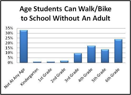
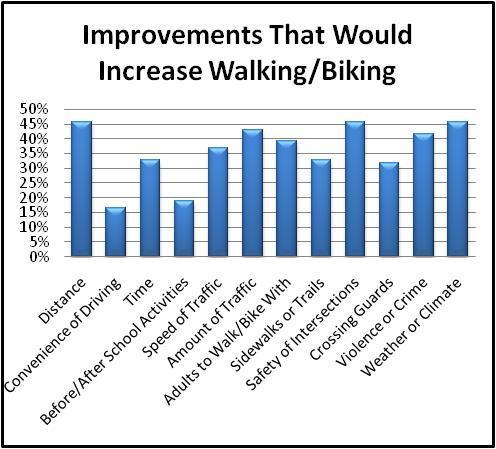
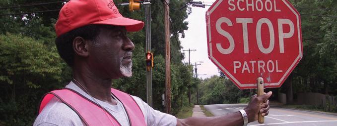
6 Group of students crossing with student patrols at the 3rd Street N/9 th Avenue intersection after school. A parent survey of concerns and attitudes related to walking and biking was also conducted in October 2010, with approximately 100 responses. About 50 percent of the respondents reported that they live less than 1 mile from school, which is consistent with the data provided by the South St. Paul School District. About 44 percent said their child had asked permission to walk or bike to school in the last year, compared with only 20 percent that said their child normally walks or bikes to school. Intersection safety and weather were the key factors that parents cited as influencing their decision to allow students to walk or bike, with distance and speed/amount of traffic also frequently listed. The charts on the following pages show some of the other key results from the survey. A sample of the parent comments from the survey is also included in the Appendix. Safe Routes to School Comprehensive Plan P a g e 5

7 Safe Routes to School Comprehensive Plan P a g e 6

8 Safe Routes to School Comprehensive Plan P a g e 7

9 Infrastructure The City of South St. Paul was rated as the most walkable city on the Dakota County Walkability Scorecard. The roadways immediately surrounding Lincoln Center generally have a well-connected system of north-south sidewalks on both sides of the roadways, including 9 th Avenue and 12 th Avenue. However, the sidewalk on 3rd Street N and 4th Street N ends west of Veteran s Field and the adjacent east-west residential streets generally do not have any sidewalks. Students walking in the roadway on 3rd Street N where there is no sidewalk. There are currently six school patrolled crossings on the roadways surrounding the school: 3rd Street N/12 th Avenue 3 rd Street N/11 th Avenue 3 rd Street N/10 th Avenue 3rd Street N/9 th Avenue/Park Lane 4th Street N/12 th Avenue 4th Street N/9 th Avenue All of the patrolled intersections have marked crosswalks, but only the intersections on 9 th Avenue and 12 th Avenue are signed as school crossings. There are also signed school crossings at Marie Avenue/10 th Avenue, Marie Avenue/9 th Avenue, and the south intersection of 3 rd Street N/9 th Avenue between the Safe Routes to School Comprehensive Plan P a g e 8


10 elementary school and middle/high school. The school also has two bike racks on the north side of the school. Based on the data collected in fall 2010, few students currently bike to school. Two bike racks located near Door 3, on the north side of the school. The speed limit of all the roadways around the school is 30 miles per hour (mph). Both 3rd Street N and 4th Street N have posted school speed zones of 20 mph. School speed zone on 3 rd Street N in front of Lincoln Center Elementary. The South St. Paul Police Department conducts frequent patrols of the school area during afternoon dismissal. Safe Routes to School Comprehensive Plan P a g e 9
11 A review of the crash history for the past ten years ( ) was completed for the area around the school bounded by 21 st Avenue, Southview Boulevard, 2 nd Avenue, and Congress Street. There have been a number of pedestrian and bicycle crashes, which are generally summarized as follows: Type: o 52 total pedestrian and bike crashes o Majority were bike crashes (approximately 70%) Location: o 30 crashes occurred on Southview Boulevard o 10 crashes occurred on Marie Avenue o 10 crashes occurred on 12 th Avenue o The intersections with the most crashes were 12 th Avenue/Southview Boulevard (6 crashes) and 7 th Avenue/Southview Boulevard (5 crashes) o Two crashes occurred adjacent to Lincoln Center (9 th Avenue/3rd Street N and 12 th Avenue/4th Street N), but happened after 7 pm and therefore were not likely related to the school Pedestrian/Bicyclist Characteristics: o No crashes involved children 0-5 years old o 27% of crashes involved a child 6-12 years old (elementary age) o 46% of crashes involved a child years old (middle/high school age) o The remaining 27% of crashes involved an adult pedestrian or bicyclist Time of Day: o 5 crashes occurred between 7 AM and 8:30 AM (before school) on a weekday during the school year o 15 crashes occurred between 2 PM and 5 PM (after school) on a weekday during the school year The number of crashes on Southview Boulevard and the ages of the pedestrian and bicyclists involved in the crashes are both concerns. A review of the intersections on Southview Boulevard showed that the signalized intersections all have marked crosswalks and pedestrian indications. There are no bike lanes or trails on or crossing Southview Boulevard. Southview Boulevard has approximately 10,500 vehicles per day and there is one lane in each direction, along with turn lanes at some intersections. While the area immediately around Lincoln Center would be considered safe for walking and biking, Southview Boulevard and 12 th Avenue both present barriers to walking and biking to school from a safety perspective. Safe Routes to School Comprehensive Plan P a g e 10

12 Site Evaluation Pavement message and marked crosswalks at the Southview Boulevard/9 th Avenue intersection. A site evaluation was completed at Lincoln Center Elementary in October 2010 that included walking around the site and observing the dismissal process on a typical day. The parking lots on 9 th Avenue and 4 th Street N are closed during dismissal and are signed for no pick-up or drop-off traffic. In addition, 9 th Avenue is signed for bus loading and unloading only, although some parked parent vehicles were also observed. All parent vehicles are instructed to drop-off and pick-up students on either 3rd Street N (last name beginning with A-L) or 4 th Street N (last name beginning with M-Z). The pick-up and drop-off procedures are included on the school s website and there are school staff that assist with arrival and dismissal each day. In addition to the curb space adjacent to the school, vehicles also parked on the local streets south of the school and on 3 rd Street N and 4 th Street N east of the school. Safe Routes to School Comprehensive Plan P a g e 11


13 Afternoon pick-up on 4 th Street N. Parents park along the curb, but also pick up students from the driving lane, which is a safety concern with students walking between parked vehicles into the roadway. Signing for Lincoln Center parking lots and pick-up/drop-off areas. The very large volume of parent traffic results in about minutes of congestion around the school, which also contributes to safety concerns such as students and parents crossing mid-block and entering the street between parked vehicles. Many of the students being driven to school live within the walk area. However, the area east of 15 th Avenue, north of Southview Boulevard, and south of Thompson Safe Routes to School Comprehensive Plan P a g e 12

14 Avenue is the most walkable and bikeable neighborhood based on the existing sidewalks and lack or major roadway crossings. Parent vehicles parked in the bus loading zone on 9 th Avenue. South St. Paul High School and Middle School has start and end times just before Lincoln Center and some middle and high school activities take place at Lincoln, so the middle and high school traffic contributes to congestion around Lincoln Center, as well as perceptions of safety issues. The crash analysis showed that of all the crashes that occurred in the analysis area, 26 percent involved a year old driver. This is in comparison to an average of 21 percent of crashes involving a year old driver in Dakota County. The City of South St. Paul has explored options for traffic calming measures in the past, and currently shares a mobile speed wagon with the cities of West St. Paul and Inver Grove Heights. Measures such as speed humps have not been well-received by residents, but temporary speed humps would be considered by the city. Safe Routes to School Comprehensive Plan P a g e 13

15 Existing Issues and Challenges Example of a mobile speed wagon that displays driver speeds. In addition to the data collection and site evaluation completed as part of this project, a Safe Routes Working Group was established for Lincoln Center Elementary that included the school principal, teachers, the City of South St. Paul, and parent representatives. The role of this group was to identify and discuss barriers to walking and biking to school as well as potential ways to overcome the barriers. The existing challenges to walking and biking to Lincoln Center Elementary are summarized in the following bullets, as well as the Existing Conditions/Issues map at the end of this report: Lack of sidewalks on many of the city streets, which results in students being driven to school or walking in the street. The volume of parent pick-up and drop-off traffic creates significant congestion and conflicts in the morning and afternoon. Double parking and pick-up from both the parking and driving lanes on 4 th Street N at school dismissal are significant pedestrian safety concerns. The traffic volumes on the roadways around the school contribute to the perception that it is not safe to walk or bike. Vehicle speeds on 3 rd Street N and 4 th Street N are a concern. Safe Routes to School Comprehensive Plan P a g e 14
16 High school and middle school traffic contributes to the overall traffic and safety concerns. Southview Boulevard and 12 th Avenue are seen as barriers to walking and biking due to the vehicle volumes and history of bicycle/vehicle and pedestrian/vehicle crashes. Recommendations Despite some of the current challenges to walking and biking to Lincoln Center Elementary, the school s location adjacent to the neighborhoods it draws students from does provide opportunities to significantly increase the numbers of students regularly walking and biking to school. In addition, as an independent school district, there is clearly a strong community connection to the school. The following recommendations have been developed specifically for Lincoln Center Elementary to address the identified challenges to walking and biking. The short-term recommendations are actions that could be implemented during the school year, while the long-term recommendations may require policy changes, additional discussion and coordination, or significant funding sources. In addition to the recommendations, the group that should take the lead in implementing the recommendation has also been identified. Short-Term Recommendations The short-term recommendations included in this section primarily consist of low-cost improvements that can be implemented in the next six months, although some are dependent on funding availability. The recommendations are generally prioritized in terms of actions that are easiest or most necessary to complete first. The infrastructure recommendations are also summarized on the Recommendations map at the end of this report. 1. Lincoln Center is doing an excellent job with the existing school patrols around the school. Based on the volume of vehicle and pedestrian traffic, it is strongly recommended that the patrols wear reflective vests to make the students more visible, particularly in low light conditions. The addition of an adult volunteer or staff to the school patrols would help provide safe crossings at the busiest intersections (3 rd Street N/9 th Avenue and 4 th Street N/9 th Avenue). Training opportunities for the patrols should also be pursued if possible. Implementation lead Lincoln Center. 2. Sign the school patrolled intersections of 3 rd Street N/10 th Avenue and 3 rd Street N/11 th Avenue as school crossings. Lincoln Center only needs to make a request to the city for Safe Routes to School Comprehensive Plan P a g e 15

17 the signing to be installed. Implementation lead City of South St. Paul, with a request from Lincoln Center. Pedestrians crossing with the school patrol at the 3 rd Street N/10 th Avenue intersection. The crosswalk on 3 rd Street N is marked, but is not signed as a school crossing. 3. Establish a permanent Safe Routes committee at Lincoln Center Elementary to provide on-going support and organization for Safe Routes activities, including regular Walk/Bike days, adult walk/bike volunteers, and special events. Implementation lead Lincoln Center. 4. Start a monthly Walk to School or Walk Home from School day with parent volunteers for key crossing locations or to walk with the students, as needed. There may be opportunities to partner with the Parent Teacher Association (PTA) to organize and hold these events. Implementation lead Lincoln Center. 5. Establish No Parking clearance zones at the key school crossing locations on 3 rd Street N and 4 th Street N to provide better sight lines of pedestrians entering the crosswalk. Implementation lead City of South St. Paul. Safe Routes to School Comprehensive Plan P a g e 16

18 Vehicles parked on 3 rd Street N up to the crosswalk at 10 th Avenue. The parked vehicles limit the visibility of pedestrians as they step off the curb to cross. 6. Investigate the feasibility of remote pick-up/drop-off sites on 3 rd Street N and 4 th Street N adjacent to Veteran s Field. The remote sites would reduce vehicle traffic next to the school and could also be used for school bus and parent pick-up/drop-off on the designated Walk/Bike days, to provide opportunities for physical activity even for students that live too far away to walk or bike to school. This would require increased adult supervision between the remote sites and the school site. Implementation lead Lincoln Center. Safe Routes to School Comprehensive Plan P a g e 17

19 Curb space and sidewalk on 4 th Street N adjacent to Veteran s Field, one block west of Lincoln Center Elementary. 7. Permanently install bike racks at both the north and south entrances to the school to provide a greater supply of bike parking, as well as making it convenient. An incentive walking/biking program with bike locks or bike helmets as rewards could also be implemented to make sure all students have the necessary bike safety equipment. Implementation lead Lincoln Center. 8. Initiate a pedestrian safety education program and continue the bicycle safety education program to teach students how to safely walk and bike to and from school. This could include in-classroom instruction, an after school walking or biking club, or a bike rodeo. Implementation lead Lincoln Center. 9. Organize a walking school bus 1 or bike train for student to walk and bike together as a group to and from school. The best potential for this would be for students that live north or west of the school and have informal groups walking home. For adequate adult supervision, the United States Centers for Disease Control and Prevention recommend 1 A walking school bus is a group of children walking to school with one or more adults. It can be as informal as two families taking turns walking their children to school to as structured as a route with meeting points, a timetable and a regularly rotated schedule of trained volunteers. Safe Routes to School Comprehensive Plan P a g e 18

20 Long-Term Recommendations one adult for every three children ages 4-6 and one adult for every six children ages 7-9. Implementation lead Lincoln Center. The long-term recommendations included in this section primarily consist of higher cost improvements or actions that would require a significant policy change, either of which would be expected to take longer than six months to occur. These recommendations are generally prioritized in order of importance, however funding availability may mean that the highest priority recommendations are not the first to be implemented. The infrastructure recommendations are also summarized on the Recommendations map at the end of this report. 1. Construct sidewalk on 3 rd Street N between 12 th Avenue and 13 th Avenue to provide a continuous sidewalk route from the south side of Lincoln Center to Veteran s Field. Implementation lead City of South St. Paul. Sidewalk gap on 3 rd Street N between 13 th Avenue and 14 th Avenue. Pedestrian traffic in this block is apparent from the worn path in the grass. 2. Develop a Safe Routes page on the Lincoln Center website that provides walking/biking route information as well as other information, such as the schedule of Walk/Bike days Safe Routes to School Comprehensive Plan P a g e 19

21 and safe walking/biking tips similar to the existing information about biking to school. Implementation lead Lincoln Center/South St. Paul School District. 3. Conduct a joint bike/walk mapping project with South St. Paul middle or high school students. Students collect information about available routes and develop maps of routes to and from school, as well as other key safe locations like libraries, police station, other schools, or community center. This project could be done as part of a class, by the National Honor Society, or other student clubs or groups. Implementation lead South St. Paul School District/South St. Paul High School and Middle School. Example of a school walk/bike route map. 4. Investigate the feasibility of additional pedestrian/bicycle enhancements for crossings of Southview Boulevard and 12 th Avenue, such as curb bump-outs or countdown timers at the signalized intersections. Restricting right turns on red at the Southview Safe Routes to School Comprehensive Plan P a g e 20

22 Boulevard/12 th Avenue intersection may also need to be considered, but should first be studied further to determine the number of right-turn/pedestrian conflicts compared to the impacts on traffic operations. Implementation lead City of South St. Paul, with support from Dakota County Transportation. Existing conditions at the Southview Boulevard/12 th Avenue intersection. 5. Investigate the feasibility of traffic calming measures on the local streets around the school, such as curb bump-outs at intersections or temporary speed bumps. Implementation lead City of South St. Paul. 6. Pursue opportunities for construction of new sidewalk segments as part of other street or utility projects to create a more complete pedestrian network. Construction of new sidewalk is dependent on resident approval and the winter maintenance is required to be done by residents. The city is currently working on a project to construct trail along Southview Boulevard, east of TH 52, which has no assessments associated with it. Implementation lead City of South St. Paul. Safe Routes to School Comprehensive Plan P a g e 21
23 Funding and Implementation Funding for the various recommended projects may come from a variety of sources depending on the type of project and who is implementing it. Some potential funding opportunities that currently exist and may be used to fund these recommendations include, but are not limited to: Statewide Health Improvement Program funds, which are available through several programs administered by Dakota County Public Health: o Safe Routes to School grants o Active Living grants, which are available to cities in Dakota County, but may be used to fund improvements off school sites o Assistance with preparation of infrastructure grant applications. Cities in Dakota County can submit infrastructure projects and the County s consultant will assist in identifying potential funding sources and preparing applications. Blue Cross Blue Shield of Minnesota Mini-grants through the National Center for Safe Routes to School Federal Transportation Enhancement (TE) funds through the Metropolitan Council Federal Safe Routes to School funds through the Minnesota Department of Transportation. The federal Safe Routes to School program was originally funded through fiscal year 2009, but Mn/DOT is expected to have another grant solicitation in spring Future funding will be dependent on passage of the Federal Surface Transportation Reauthorization Bill, which is still being discussed in the United States Congress. Increased liability of the school, school district, or adult volunteers as a result of encouraging walking and biking to school is a frequent concern when implementing Safe Routes to School programs. In general, encouraging walking and biking to school does not increase the liability of the school or the district. Some tips and guidelines from the National Center for Safe Routes and the Public Health Law Center are included in the appendix of this report as a reference. Links to additional resources such as an overall Safe Routes to School guide, walking school bus guide, and safety education materials are also provided in the appendix. No one of the E s of Safe Routes to School will by itself increase walking and biking, which emphasizes the need for cooperation among school, city, county and other agencies. The process used to develop this plan is only the start of on-going efforts that will be needed to result in cultural changes and significant increases in walking and biking. Safe Routes to School Comprehensive Plan P a g e 22
24 TH AVE S 14TH AVE N 12TH AVE S 12TH AVE N 11TH AVE N 11TH AVE N 9TH AVE N 9TH AVE N 13TH AVE N 10TH AVE N 8TH AVE N STEWART AVE CONCORD PL CONCORD ST N CONGRESS ST 7TH AVE N RAVINE ST DWANE ST WENTWORTH AVE TURIN AVE 16TH AVE N 14TH AVE N 1,600 VEHICLES/DAY ËÌ 123 PARENT PICK-UP/ DROP-OFF A-L WENTWORTH AVE 16TH AVE S 89:w ÅÆÇ ^_ nm LEGEND TH AVE N RD ST N 2ND ST N VETERAN'S FIELD 14TH AVE S SCHOOL CROSSING CROSSWALK SCHOOL PATROL LOCATION SIDEWALKS MUTLI-USE TRAILS ON-SITE SIDEWALKS WALK AREA PUBLIC SCHOOL 89:w 3,000 VEHICLES/DAY SIDEWALK GAP 13TH AVE N 89:w BICYCLE RACKS "½ NOTE: SIDEWALKS SHOWN ON MAJOR ROUTES ONLY FOR CLARITY. 13TH AVE S ÅÆÇ^_ ËÌ 123 ÅÆÇ^_ "½ nm ÅÆÇ^_ ËÌ 123 èëì Feet ^_ 11TH AVE S LINCOLN CENTER ELEMENTARY ËÌ 123 SOUTHVIEW BLVD 4TH ST N ^_ PARENT PICK-UP/ DROP-OFF M-Z 10TH AVE N ÅÆÇ 10TH AVE S ÅÆÇ^_ ÅÆÇ 89:w ÅÆÇ 9TH AVE S 89:w BUS LOADING SOUTH ST. PAUL SECONDARY SCHOOL 8TH AVE S PARK LN 2ND ST N 8TH AVE N MARIE AVE 3RD ST N 7TH AVE S èëì 7TH AVE N nm KAPOSIA BLVD 6TH AVE S 6TH AVE N 5TH AVE S 5TH AVE N 2ND ST N 89:w GRAND AVE LINCOLN CENTER ELEMENTARY SCHOOL EXISTING CONDITIONS/ISSUES
25 15TH AVE S 12TH AVE S 14TH AVE N 12TH AVE N 11TH AVE N 11TH AVE N 9TH AVE N 8TH AVE N CONSIDER ADULT CROSSING GUARDS 13TH AVE N 10TH AVE N 2 - SIGN SCHOOL CROSSING 3 - SIGN NO PARKING CLEARANCE ZONES AT CROSSWALKS 4 - INSTALL BICYCLE RACKS 5 - POTENTIAL REMOTE PICK-UP/DROP-OFF LOCATION CONGRESS ST 6 - CONSTRUCT SIDEWALK/TRAIL CONNECTION 7 - INVESTIGATE FEASIBILITY OF PEDESTRIAN ENHANCEMENTS OR TRAFFIC CALMING RAVINE ST 9TH AVE N DWANE ST STEWART AVE 16TH AVE N WENTWORTH AVE 14TH AVE N ËÌ 123 WENTWORTH AVE TURIN AVE 16TH AVE S 89:w ÅÆÇ ^_ nm LEGEND TH AVE N RD ST N 2ND ST N VETERAN'S FIELD 14TH AVE S SCHOOL CROSSING CROSSWALK 89:w 5 SCHOOL PATROL LOCATION SIDEWALKS MUTLI-USE TRAILS ON-SITE SIDEWALKS WALK AREA PUBLIC SCHOOL 5 13TH AVE N 89:w BICYCLE RACKS "½ NOTE: SIDEWALKS SHOWN ON MAJOR ROUTES ONLY FOR CLARITY. 13TH AVE S 6 ÅÆÇ^_ ËÌ 123 ÅÆÇ^_ "½ nm ÅÆÇ^_ ËÌ 123 èëì Feet ^_ 11TH AVE S 7 ËÌ 123 LINCOLN CENTER ELEMENTARY ^_ 2 2 SOUTHVIEW BLVD 4TH ST N 10TH AVE N ÅÆÇ 10TH AVE S 3 4 ÅÆÇ^_ 3 ÅÆÇ 89:w 7 ÅÆÇ 9TH AVE S 89:w 1 8TH AVE S PARK LN 2ND ST N SOUTH ST. PAUL SECONDARY SCHOOL 8TH AVE N MARIE AVE 3RD ST N 7TH AVE S èëì 7TH AVE N nm KAPOSIA BLVD 6TH AVE S 6TH AVE N 5TH AVE S 5TH AVE N 2ND ST N 89:w GRAND AVE LINCOLN CENTER ELEMENTARY SCHOOL RECOMMENDATIONS
26 Appendix
27 Parent Survey Comments I feel that 1.5 miles is WAY too far for a child in elementary school to be walking. I live about 1.3 miles away and there is no way they will ever have to walk. I think this is completely ridiculous that they are expected to walk. Especially down Thompson Ave and 12th Ave. They are very busy main streets and it is not safe for them to be walking. Violence and crime worries me for all students. I feel better about HS students walking NOT elementary. MORE police presents would be good! My son goes to a friend s house in the morning and a group of them walk together from there. After school he rides the bus. Kids in K and 1st grade should be provided transportation to and from school free of charge no matter how close they are because there are parents out there that do not see the dangers out there like myself and they WILL be walking. I am fortunate to be able to have the sense and the means to get my children to school safely. I think that kids should be able to ride a bus during winter no matter how far school is and no kid should have to cross Southview without an adult. With there being very little sidewalks in South St Paul and our distance of more than a mile we are not comfortable having him walk. There is also risk of harm from people and other things to worry about without an adult to go with and if we are going with than we might as well drive him! Especially in the bad weather. I think it's important for kids to transport themselves to school so they can: 1. be healthy; 2. have a sense of independence and responsibility! I would allow my child to walk/bike to school without at an adult at 6 years old, but only with a buddy. I'm so glad you are doing this. I would love a bicycling group (if an adult is present). I would have carpooled last year, if we had the chance. If there was a way to arrange a bike or walk "pool" where a group of them met up and rode/walked together. We walk when it is nice out and we drive when late or weather is not fun to walk in. When I am sure he will make it to class on time with all items needed and everything put in his locker I have no problem letting him walk by himself. Cars drive right thru when the guards have flags out. People letting kids run across street from cars to school and school to cars. People stopping in middle of street to pick up kids. It is such an out of control situation. The ONLY way I can assure my kids' safety is to bring them and pick them up myself. My kids don't have to cross the street ever. Age is the factor - she's too young. Safe Routes to School Comprehensive Plan
28 Too much traffic around high school. Too many driveways intersecting sidewalk from high school that need to be crossed or no good corner to cross at. Cars do not stop at crosswalk from high school to baseball field. We live too far from school and I fear for their safety if I let them walk. Most people who drive around here DO NOT follow crosswalk laws. My children would love to bike but I do not feel comfortable allowing them to. Too many child abductions for this to be possible. I want the school bus to be an option. Way too young and SSP streets are not safe, nor is the route to school. Steep hills/streets and no sidewalks scare us. That is why we will not let our kids walk or bike to school. My children have been harassed and bullied, especially on the way home from school. The incidents involved several different children from Lincoln Center and other instances involved junior or senior high bullies. I responded by showing my presence, it stopped each time and hopefully won't start again. Safe Routes to School Comprehensive Plan

29 National Center for Safe Routes to School Safe Routes to School Programs and Liability Tip Sheet For 10 Tips SafeRoutes Background and Overview Forty years ago, nearly 90 percent of children who lived close to their school walked or bicycled to get there. Today, this number has decreased by about 25 percent.1 As Safe Routes to School (SRTS) programs have developed to reverse this trend, some have wondered if encouraging walking and bicycling to school may increase a school s liability exposure. In general, the answer is no. In fact, SRTS programs are designed to help schools and communities identify and address potential safety concerns. Taking concrete steps to make walking and bicycling safer will reduce the likelihood of injury, and thereby minimize exposure to liability. A SRTS program that simply encourages or promotes bicycling and walking to school should not, in most cases, expose schools to increased liability risk. Even school-sponsored walking and bicycling programs, such as a Walking School Bus or Bicycle Train should not expose schools to any greater liability than other school-sponsored activities. Of course, schools with SRTS programs must ensure they are meeting their responsibilities for children s safety just as they must routinely do with all other forms of school transportation and with other school activities. SRTS programs can vary greatly, ranging from programs to encourage walking and bicycling to active sponsorship of walking and bicycling programs and providing new infrastructure to support these activities. The school s responsibility for safety will vary according to the individual elements of the SRTS program and the local legal context. The information below provides a brief overview of the relevant legal definitions and identifies several issues you may want to look into as you develop your program to ensure you are addressing any potential liability issues. This information is not intended as legal advice and should not be used as such. For specific legal guidance, you should consult with an attorney with relevant knowledge and experience. Legal Context Schools and school districts must regularly address issues of liability for a variety of school programs and school sponsored activities. Regardless of whether students walk, bike, take the bus, or are driven to school, there is a possibility that an injury may occur on or off school property. However, not all injuries result in liability. The extent to which a school will be held legally responsible or liable for its negligent actions or omissions depends on the facts of a given case, on laws and legal principles that vary from state to state, and even from school district to school district. In general, to establish liability for negligence, the injured person or someone acting on his or her behalf must show that the school owed a legal duty of care to that person, that the school breached that duty, and that the breach was the proximate cause of damages or injury.2 (Visit Law.com and search liability and negligence for more detailed definitions and descriptions.)

30 10 Tips Safe Routes to School Programs and Liability (continued) For A school s duty of care to students and resulting legal liability when students are injured is very situational and can only be assessed in the context of the specific program or activity and with knowledge of the specific facts giving rise to an injury. Relevant factors are likely to include: the degree to which the school controls or directs the activity that results in injury, the extent to which the school s actions conformed to applicable rules, regulations, policies, or procedures, and the extent to which the school knew or should have known of a particular hazard and failed to correct or warn against it. A school will not ordinarily be held liable for injuries sustained by children while they are walking or bicycling to school simply because the school encourages children to walk or bike, where injuries occur off school property, and parents have been reminded that the school is not responsible for supervising children who walk or bike to school. To avoid liability for negligence, the school must exercise reasonable care under the circumstances. If the school directly sponsors walking or bicycling activities such as a Walking School Bus or Bike Train, the school generally has greater responsibilities just as they would for other schoolsponsored forms of transportation. At a minimum, the school should follow the recommended procedures outlined in the National Center for SRTS publication, The Walking School Bus: Combining Safety, Fun and the Walk to School ( index.cfm) as well as any rules, policies, or protocols established by the school district for school-sponsored activities occurring off school property. (For example, volunteer training, screening, or adult to child ratios.) Minimizing Risk Even though SRTS programs are designed to make walking and bicycling safer for students, there are certain steps the school should take to minimize the risk that the school will be held liable for negligence in the event that a student is hurt while walking or bicycling to school. Some key measures are detailed below. References 1. In 1969, 87 percent of children 5 to 18 years of age who lived within one mile of school walked or bicycled to school. In 2001, 63 percent of children 5 to 18 years of age who lived within one mile of school walked or bicycled to school. U.S. Centers for Disease Control and Prevention. Kids Walk-to-School: Then and Now Barrier and Solutions. Available: Accessed: January 17, Schools Legal Service, Orange County Department of Education School Districts and School District Employees Liability for Negligence. Costa Mesa, CA.

31 10 Tips Safe Routes to School Programs and Liability (continued) For 1 the Work with your school district s administrative and legal staff to understand relevant liability issues and to develop appropriate policies. Most likely, your school district already has a number of policies in place to help manage its liability for various school programs and activities. A SRTS program is no different. You should work closely with your school district s administrative and legal staff to identify any particular risk management and insurance needs based on your individual SRTS program and the relevant laws of your jurisdiction. 2 If Be aware of local laws, regulations, and school policies. Work with your school s legal counsel to identify the laws and regulations in your jurisdiction that are relevant to walking and bicycling. These may include laws regarding school safety patrols, the designation of school walking routes (some states require them), student bus transportation, and any bicycle safety requirements such as helmets, bells or lights. You should also review the state and local pedestrian laws and portions of the local development code regarding pedestrian safety and provision of pedestrian accommodations. Make sure you are following any applicable school policies, such as parental permission slips, waivers, or required supervision for school-sponsored activities. If appropriate, your school may consider making modifications or exceptions to any school policies that appear to be in conflict with your SRTS activities. 3 4 Develop Take steps to fix problems. you are aware of unsafe walking and bicycling conditions, such as unsafe vehicle drop off and pick up conditions, take steps to fix them. Even if the problem is not subject to the school s control, such as a heavily trafficked local street, the school should warn parents of any known hazards, and take any prudent steps to address conditions under the school s control that might exacerbate the risk of injury. Be proactive. a plan. Developing a SRTS Plan for an individual school is a great way to identify potential safety problems and prioritize needed improvements. If you identify problems, take steps to address the problems and inform the school community of possible hazards that cannot be or have not yet been corrected. 5 Document your efforts. If you are aware of potential problems, document your efforts to fix them. For example, if you are made aware of problems with speeding vehicles in the school area, keep records of your communication with law enforcement officials to address the problem and your communications to parents warning them of any uncorrected problems.
32 10 Tips Safe Routes to School Programs and Liability (continued) For 6 Parents 8 Be uniform, systematic and consistent in undertaking safety improvements. In making improvements such as new sidewalks or improved crossings, follow accepted engineering and design practices. Any design exceptions should be carefully reviewed so as not to compromise safety. Consider waivers. Where a SRTS program sponsors specific transportation activities, such as a walking school bus or bicycle train, a school may decide to require parent volunteers and parents of student participants to sign waivers or permission slips acknowledging that the participants are assuming the risk of injury by engaging in walking and bicycling activities, and waiving any claims against the school for its negligent acts or omissions. Keep in mind that waivers need to be carefully drafted in order to be effective. 7 Inform and involve parents. and designated caretakers are ultimately responsible for deciding how their children get to school. Material promoting SRTS programs should make clear that parents should determine their child s readiness and the best route for walking and bicycling. Encourage parents to accompany younger children. Let parents know the location of signalized or marked crossings and locations with crossing guards and recommend that they use them. Provide pedestrian and bicycle safety tips to parents as well as students. (See safety tip sheets at the National Center s Web site at resources/education_tip-sheets.cfm) 9 Make Obtain adequate insurance coverage for your program. Your school district is likely to have a large umbrella policy that covers a range of school programs and school sponsored activities. Review this policy to ensure the SRTS activities you are organizing are covered. If they are not, have the policy adjusted to include these activities. 10 Provide training. sure crossing guards and school employees working on traffic and safety issues are well trained regarding pedestrian and bicycle safety and their responsibilities for ensuring that children are safe on their journey to and from school. Provide training to volunteers, and if appropriate, screening, where volunteers will be supervising children as part of a SRTS activity, such as a formal Walking School Bus or Bike Train. SafeRoutes National Center for Safe Routes to School For more resources and information on Safe Routes to School, please visit the National Center for Safe Routes to School Web site at


33 ` LIABILITY FOR VOLUNTEERS IN THE WALKING SCHOOL BUS PROGRAM A Walking School Bus Program aims to get children walking to and from school in groups accompanied by adults. It encourages students and adults to be more physically active and social. The program is ideal for neighborhoods that have a school within walking distance. Adult volunteers are essential to the Walking School Bus Program. They are responsible for organizing the program and for walking the children to and from school. Adult volunteers are expected to act responsibly just as they would with their own children. Provided that adult volunteers act reasonably and with good intention, a Minnesota statute will protect them from liability claims for accidents that occur during the course of volunteering. Q: What is liability? A: Put simply, liability is a legal responsibility. Typically, for you to be held liable, someone must prove that: You owed them a duty of care; You failed to perform that duty or did so negligently; and Your negligence caused someone harm that could have reasonably been expected to occur. Q: What is a person s duty of care? A: The duty you owe someone depends on the circumstances. Generally, everyone has the duty to act with reasonable care toward others. What is considered reasonable also depends on the circumstances. Q: What is negligence? A: Negligence is the failure to act as carefully as an ordinary, reasonable person would in the same situation. Q: What is cause of harm? A: Cause of harm means that your action was an important factor in causing the harm and that you could have reasonably expected the injury to occur. Q: Are there any Minnesota laws that provide added protection to volunteers? A: Yes. Under a Minnesota law, volunteers will generally not be liable for a child s injuries if their actions (1) were in good faith, (2) within the scope of their duties, and (3) not willful or reckless.

34 Q: What does acting in good faith mean? A: This means acting with a good, honest intention or belief. Good Faith: A volunteer takes the children down a different route one day, believing the traffic will be lighter. The traffic is actually heavier, and a car hits a child while he is crossing the road in a crosswalk. Not Good Faith: A child misbehaves during the walk. The volunteer makes the child walk home by himself, knowing that the child does not know the way home. The child gets lost and is injured. Q: What does acting within the scope of their duties mean? A: This means acting according to one s role or responsibilities as a volunteer. Within the Scope of Duties: A student slips and is injured while the volunteer is walking the student to school. Not Within Scope of Duties: After school, a student stays over at a volunteer s house to play with the volunteer s children. The student slips and is injured. Q: What is willful or reckless conduct? A: This means acting with disregard for the safety of others, or failing to act with ordinary care to prevent or discover a danger. Some examples of willful or reckless conduct might include: telling a child to run across the street when the light is red; telling children to cross the road without looking both ways; or making children walk long distances in extreme heat without water. Q: If I am sued, will insurance cover the costs of the litigation? A: Check the terms of your homeowner s or renter s insurance policy to learn what is covered. Typically, insurance consists of two parts property coverage and personal liability coverage. The personal liability portion of the policy may protect against a lawsuit brought by someone who is injured by something you do. It will pay for damages or medical expenses if you are responsible for the injury. Also, it will pay for legal expenses to defend you if the lawsuit is unjustified. Q: How can Walking School Bus Program volunteers reduce the risk of liability? A: Common sense precautions go a long way toward avoiding liability risk. Most importantly, a parent volunteer should act like an ordinary, reasonable person. Additional steps could be: Creating safety rules and handing them out to all students and parents. These safety rules should comply with any local school rules. Planning a training day for students and volunteers. Wearing fluorescent vests while walking with the children. Asking the parents or guardians to sign a waiver saying they will not hold you liable for any injuries. (Please refer to the Public Health Law Center s Waivers and Releases Fact Sheet.) Eliminating dangers, where possible. Having one adult volunteer for every six children over the age of 10 and one adult volunteer per three children for four to six year-olds. Documenting all precautions taken to avoid harm or risk. For related publications, visit Click on Publications and Resources link and then on Fact Sheets. The Public Health Law Center provides information and technical assistance on issues related to tobacco and public health. The Public Health Law Center does not provide legal representation or advice. This document should not be considered legal advice. For specific legal questions, consult with an attorney. Contact the Public Health Law Center for citations used in this factsheet. Updated July 2010.


35 Safe Routes to School guide saferoutesinfo.org

36
37 SafeRoutes National Center for Safe Routes to School
38
Safe Routes to School Comprehensive Plan
 Safe Routes to School Comprehensive Plan City of Apple Valley Dakota County, MN May 2010 Prepared by: Project Background The Statewide Health Improvement Program (SHIP) aims to help Minnesotans live longer,
Safe Routes to School Comprehensive Plan
 Safe Routes to School Comprehensive Plan City of Rosemount Dakota County, MN June 2010 Prepared by: Project Background The Statewide Health Improvement Program (SHIP) aims to help Minnesotans live longer,
Parent Survey Report: One School in One Data Collection Period
 Parent Survey Report: One School in One Data Collection Period School Name: Broken Arrow Elementary School Set ID: 12172 School Group: Douglas County Month and Year Collected: October 2014 School Enrollment:
Safe Routes to School Comprehensive Plan
 Safe Routes to School Comprehensive Plan City of Rosemount Dakota County, MN June 2010 Prepared by: Project Background The Statewide Health Improvement Program (SHIP) aims to help Minnesotans live longer,
Bringing together community and health. Physical Activity and Nutrition Unit Office of Statewide Health Improvement Initiatives
 Bringing together community and health. Physical Activity and Nutrition Unit Office of Statewide Health Improvement Initiatives Physical Activity and Nutrition Unit Office of Statewide Health Improvement
SAFE ROUTES TO SCHOOL
 SAFE ROUTES TO SCHOOL Forest Ridge Elementary School Existing Conditions and ACTION PLAN > Oak Creek - Franklin Joint School District Table of Contents CONTEXT Enrollment Boundaries
Safe Routes to School Comprehensive Plan
 Safe Routes to School Comprehensive Plan City of Hastings Dakota County, MN December 2010 Prepared by: Project Background The Statewide Health Improvement Program (SHIP) aims to help Minnesotans live longer,
S A F E R O U T E S T O S C H O O L H E R M A N TOW N S C H O O L S A N D P R O C TO R S C H O O L S P L A N A P P R OVA L S
 S A F E R O U T E S T O S C H O O L H E R M A N TOW N S C H O O L S A N D P R O C TO R S C H O O L S P L A N A P P R OVA L S WHAT IS SAFE ROUTES TO SCHOOL? In 1969, nearly 50% of children walked or rode
SAFE ROUTES TO SCHOOL
 SAFE ROUTES TO SCHOOL Edgewood Elementary School Existing Conditions and ACTION PLAN > Oak Creek - Franklin Joint School District Table of Contents CONTEXT Enrollment Boundaries Enrollment
CITY OF OAK CREEK SAFE ROUTES TO SCHOOL ACTION PLAN. East Middle School
 CITY OF OAK CREEK SAFE ROUTES TO SCHOOL ACTION PLAN East Middle School CITY OF OAK CREEK SAFE ROUTES TO SCHOOL ACTION PLAN East Middle School Why Safe Routes to School? Safe Routes to School ( SRTS ) is
Aitkin School Routing Plan July 2010
 Aitkin School Routing Plan July 2010 Prepared by: Arrowhead Regional Development Commission Regional Planning Division Aitkin School Routing Plan July 2010 Aitkin School Routing Plan July 2010 Prepared
Summary Report School Walking & Bicycling Audits. Mesa County Regional Transportation Planning Office
 Summary Report School Walking & Bicycling Audits Mesa County Regional Transportation Planning Office This page left blank intentionally WALKING & BICYCLING AUDIT SUMMARY 2 Executive Summary Background:
July 5, Arthur R. Ware, Jr. Elementary School 2017 Safe Routes to School Walkabout Report
 July 5, 2017 Arthur R. Ware, Jr. Elementary School 2017 Safe Routes to School Walkabout Report 1 Walkabout Report Introduction On April 28, 2017, City, School, and SAWMPO staff met to conduct a Safe Routes
Vallecito Elementary School. Travel Plan
 Vallecito Elementary School Travel Plan TABLE OF CONTENTS 1. PURPOSE... 1 1.1. SR2S PLANNING, IMPLEMENTATION AND MONITORING... 1 1.2. MARIN COUNTY MEASURE A... 1 2. VALLECITO ELEMENTARY SCHOOL PROFILE...
Randolph-Hamline ( Ran-Ham ) Area Safe Routes to School Plan
 Area Safe Routes to School Plan") Randolph-Hamline ( Ran-Ham ) Area Safe Routes to School Plan Cretin Derham Hall Expo Elementary Holy Spirit Elementary Randolph Heights Elementary Saint Paul, Minnesota September 2016 Prepared By: Saint
Randolph-Hamline ( Ran-Ham ) Area Safe Routes to School Plan Cretin Derham Hall Expo Elementary Holy Spirit Elementary Randolph Heights Elementary Saint Paul, Minnesota September 2016 Prepared By: Saint
Sebastopol Charter School Traffic Management Plan
 Sebastopol Charter School The serves as the working document in support of these essential goals: to ensure the safety and efficiency of student arrival to and departure from school to ensure the safety
Lawrence Safe Routes to School. Community Meeting January 14, 2015
 Lawrence Safe Routes to School Community Meeting January 14, 2015 Safe Routes to School The 6 E s Education Encouragement Enforcement Engineering Evaluation Equity What are the elements of a SRTS plan?
About the Studio. Edward J. Bloustein School of Planning and Public Policy - Rutgers University
 About the Studio Edward J. Bloustein School of Planning and Public Policy - Rutgers University Purpose of studio: Help City of Bayonne apply for Safe Routes to School (SRTS) funding by producing a School
Parent Survey Report: One School in One Data Collection Period
 Parent Survey Report: One School in One Data Collection Period School Name: Pinckney Elementary School Set ID: 12170 School Group: Douglas County Month and Year Collected: October 2014 School Enrollment:
Parent Survey Report: One School in One Data Collection Period
 Parent Survey Report: One School in One Data Collection Period School Name: Bilquist Elementary School Set ID: 15803 School Group: Clackamas County Month and Year Collected: December 2016 School Enrollment:
PEDESTRIAN ACTION PLAN
 ATTACHMENT 2 CITY OF SANTA MONICA PEDESTRIAN ACTION PLAN CITY OF SANTA MONICA PEDESTRIAN ACTION PLAN This page intentionally left blank EXECUTIVE SUMMARY CHAPTER 1 EXECUTIVE SUMMARY Setting the Stage
AGENDA. 5. Next Steps a. Survey Distribution b. Draft Action Plan/Recommendations c. Review at next meeting in advance of document preparation
 Congdon Elementary Safe Routes to School Plan Update SRTS Team Meeting #2-Walk Audit March 21, 2018, 3:00 p.m. Congdon Elementary School Art Room-Duluth, MN 1. Welcome and Introductions 2. SRTS Review
C/CAG. Sunnybrae Elementary School Walking and Bicycling Audit. San Mateo-Foster City School District JUNE 2013
 Sunnybrae Elementary School Walking and Bicycling Audit JUNE 2013 San Mateo-Foster City School District C/CAG City/County Association of Governments of San Mateo County SUNNYBRAE ELEMENTARY SCHOOL WALKING
NM-POLICY 1: Improve service levels, participation, and options for non-motorized transportation modes throughout the County.
 Transportation PRINCE WILLIAM COUNTY 2008 COMPREHENSIVE PLAN NON-MOTORIZED PLAN CONTENTS Goals, Policies, and Action Strategies Table 4 (Bike Facility Classifications and Descriptions) Table 5 (Bike Facility
CITY OF BLOOMINGTON COMPLETE STREETS POLICY
 CITY OF BLOOMINGTON COMPLETE STREETS POLICY POLICY OBJECTIVE: The City of Bloomington will enhance safety, mobility, accessibility and convenience for transportation network users of all ages and abilities,
Hedgepeth Williams Middle School and Paul Robeson Elementary School Trenton, NJ. School Travel Plan
 Hedgepeth Williams Middle School and Paul Robeson Elementary School Trenton, NJ School Travel Plan Hedgepeth Williams Middle School Description: Hedgepeth-Williams Middle School is located at 301 Gladstone
Safe Routes to School: Neighborhood Assessment Guide
 Safe Routes to School: Neighborhood Assessment Guide September 2012 Safe Routes to School Program Minnesota Department of Transportation 395 John Ireland Blvd., Mail Stop 430 St. Paul, MN 55155 Phone:
Implementing the Three Es of School Zone Traffic Calming
 Implementing the Three Es of School Zone Traffic Calming Use this evaluation tool as a guide to analyze the specific safety needs of your school. SCHOOL PROFILE School Name: School District: Address: Phone
Chapter 2. Bellingham Bicycle Master Plan Chapter 2: Policies and Actions
 Chapter 2 Bellingham Bicycle Master Plan Chapter 2: Policies and Actions Chapter 2: Policies and Actions The Bicycle Master Plan provides a road map for making bicycling in Bellingham a viable transportation
Living Streets Policy
 Living Streets Policy Introduction Living streets balance the needs of motorists, bicyclists, pedestrians and transit riders in ways that promote safety and convenience, enhance community identity, create
Getting Your SRTS Project Funded. Ryan Snyder
 Getting Your SRTS Project Funded Ryan Snyder Steps in Submitting a Successful Application 1. Stakeholder outreach: create a SRTS coalition 2. Develop a comprehensive plan and program with all 5 Es 3. Conceive
2016 APS Go! Surveys Summary Results for Oakridge Elementary School
 2016 APS Go! Surveys Summary Results for Oakridge Elementary School This report summarizes results from the 2016 APS Go! surveys for Oakridge Elementary School. Student, parent/caregiver and staff surveys
SRTS Programs That Increase Walking and Bicycling to School
 Getting Results: SRTS Programs That Increase Walking and Bicycling to School SafeRoutes National Center for Safe Routes to School Communities initiate Safe Routes to School (SRTS) programs for a variety
Safe Routes to School
 Safe Routes to School Amy Paxton-Aiken, Center TRT University of North Carolina Chapel Hill, NC and Ian Thomas, Executive Director PedNet Coalition Columbia, MO Housekeeping If you are calling in on a
2 Mark Twain Elementary School Report
 2 Mark Twain Elementary School Report Principal: Greg Kaatz Grades: K-2 Enrollment: 323 Address: 425 N. Church Street First bell: 8:10 a.m. Silverton, OR 97381 Last bell: 2:30 p.m. Free & Reduced Lunch:
Safe Routes to School Comprehensive Plan
 Safe Routes to School Comprehensive Plan City of Mendota Heights Dakota County, MN June 2011 Prepared by: Project Background The Statewide Health Improvement Program (SHIP) aims to help Minnesotans live
CITY OF KASSON TRANSPORTATION ALTERNATIVES KASSON SAFE ROUTES TO SCHOOL
 ve ha 8t G B A Mantorville Ave N 240th Ave 16th St NE 11th Ave NE K-M HIGH SCHOOL SUNRISE TRAIL TO MANTORVILLE MNTH 57 SUNSET TRAIL TO MANTORVILLE NE PARK 16TH ST NE TRAIL K-M ELEMENTARY SCHOOL K-M MIDDLE
CITY OF WEST KELOWNA COUNCIL POLICY MANUAL
 CITY OF WEST KELOWNA COUNCIL POLICY MANUAL Page 1 of 7 DEPARTMENT: Engineering Services SUBJECT: Traffic Calming Policy (Revised June 6, 2017) Policy Statement: The provision of traffic calming measures
Safe Routes to School Guide
 Safe Routes to School Guide Steps to Creating a Safe Routes to School Program Created February 2007 SafeRoutes National Center for Safe Routes to School This guide was developed by the Pedestrian and Bicycle
Windom Area Schools District #177 Safe Routes to School Plan Winfair Elementary & the Middle School January 2014
 Windom Area Schools District #177 Safe Routes to School Plan Winfair Elementary & the Middle School January 2014 Prepared by: Southwest Regional Development Commission 2401 Broadway Avenue, Suite 1 Slayton,
Introduction.
 2307-1.0. Introduction. Delaware s Safe Routes to School (SRTS) Program was established September 10, 2002 when Governor Ruth Ann Minner signed Senate Bill 353 of the 141st General Assembly of Delaware
National Safe Routes to School Program: Initial Results
 National Safe Routes to School Program: Initial Results Lauren Marchetti National Center for Safe Routes to School 9 th Annual New Partners for Smart Growth Thursday, February 4, 2010 Seattle, WA August
3 Silverton High School Report
 3 Silverton High School Report Principal: Justin Lieuallen Grades: 9-12 Enrollment: 1,277 Address: 1456 Pine Street First bell: 7:55 a.m. Silverton, OR 97381 Last bell: 3:05 p.m. Free & Reduced Lunch:
ACTION TRANSMITTAL No
 Transportation Advisory Board of the Metropolitan Council of the Twin Cities DATE: August 25, 2016 TO: FROM: ACTION TRANSMITTAL No. 2016-47 Technical Advisory Committee TAC Funding and Programming Committee
City of Cape Coral Traffic Calming. City Council May 16,
 City of Cape Coral Traffic Calming City Council May 16, 2016 1 In This Presentation Why Traffic Calming? What is Traffic Calming? Examples Traffic Calming in the City of Cape Coral How to develop a Traffic
FLETCHER AVENUE PEDESTRIAN AND BICYCLIST BEHAVIOR CHANGE FORMATIVE RESEARCH PROJECT
 FLETCHER AVENUE PEDESTRIAN AND BICYCLIST BEHAVIOR CHANGE FORMATIVE RESEARCH PROJECT EXTENT OF CHANGES IN PEDESTRIAN AND BICYCLIST ATTITUDES AND BEHAVIORS DIRECTLY AFTER A COMPLETE STREETS PROJECT IN FLORIDA
EXECUTIVE SUMMARY. Vision
 Vision Walking and bicycling in Salt Lake City will be safe, convenient, comfortable, and viable transportation options that connect people to places, foster recreational and economic development opportunities,
Get Oregon kids. Walking, biking and rolling to school planning guide
 Get Oregon kids Walking, biking and rolling to school planning guide The Oregon Health Authority produced this guide with assistance from the Oregon Department of Education, Oregon Department of Transportation
WALKSacrame nto. Welcomes you to the 2009 Sacramento County Safe Routes to School Conference
 Sacramento County Department of Transportation Ron Vicari, Principal Civil Engineer In Partnership with: WALKSacrame nto Anne Geraghty, Terry Preston & Staff Welcomes you to the 2009 Sacramento County
Memorandum. Public Comments
 711 SE Grand Ave. Portland, OR 97214 (503) 230-9862 www.altaplanning.com Memorandum Date: November 30, 2016 To: From: Re: City of Tacoma Hannah Day-Kapell and Gena Gastaldi, Alta Planning + Design Tacoma
Safe Routes to School Action Plan Aberdeen, Idaho
 Background Aberdeen, Idaho is a largely agricultural community of nearly 2,000 people and is located in the southeast portion of the state on the western edge of American Falls Reservoir. The community
I HAVE A SAFE ROUTES TO SCHOOL PLAN, NOW WHAT? IMPLEMENTATION.
 I HAVE A SAFE ROUTES TO SCHOOL PLAN, NOW WHAT? IMPLEMENTATION. Brad Strader, AICP, PTP LSL Planning, Inc. Schools in Michigan: An Historical Perspective Then Elementary schools integrated into neighborhoods
Chapter 3.9 Timbercrest Elementary School. Volusia County MPO. November 2008
 Chapter 3.9 Timbercrest Elementary School Deltona, FL Volusia County MPO November 2008 Volusia County MPO School Bicycle and Pedestrian Review Study, Phase 3B School Summary Timbercrest Elementary School
TOWN OF PORTLAND, CONNECTICUT COMPLETE STREETS POLICY
 TOWN OF PORTLAND, CONNECTICUT COMPLETE STREETS POLICY I. VISION, GOALS & PRINCIPLES VISION To improve the streets of Portland making them safer and more accessible for all users including pedestrians,
Bicycle Master Plan Goals, Strategies, and Policies
 Bicycle Master Plan Goals, Strategies, and Policies Mobilizing 5 This chapter outlines the overarching goals, action statements, and action items Long Beach will take in order to achieve its vision of
2016 APS Go! Surveys Summary Results for Arlington Traditional School
 2016 APS Go! Surveys Summary Results for Arlington Traditional School This report summarizes results from the 2016 APS Go! surveys for Arlington Traditional School. Student, parent/caregiver and staff
Orange Center Elementary School
 Drag and drop pic and stretch/crop to the limits of the blue rectangle (delete this text box) Orange Center Elementary School Drag and drop pic and stretch/crop to the limits of the blue rectangle (delete
Madison Urban Area and Dane County. Bicycle Transportation Plan Summary. September Introduction. Bicycle Plan Scope and Planning Process
 Bicycle Transportation Plan Summary Madison Urban Area and Dane County Introduction September 2000 Bicycling is an important mode of transportation in the Madison urban area and countywide that is available
SPARE THE AIR YOUTH SCHOOLPOOL
 SPARE THE AIR YOUTH SCHOOLPOOL GUIDEBOOK Sharing the trip to school with Walking School Buses, Bike Trains, and Carpools JULY 2014 1 SCHOOLPOOL GUIDEBOOK 01 INTRODUCTION Spare the Air Youth is a regional
Barnum- Safe Routes to School Meeting #2 January 20, 2015
 Barnum- Safe Routes to School Meeting #2 January 20, 2015 1. Introductions 2. SRTS Program Overview 1. Purpose 2. Benefits 3. Background of planning Process 3. Existing Conditions Review and Summary 1.
Drag and drop pic and stretch/crop to the limits of the blue rectangle (delete this text box) Maxey Elementary School
 Maxey Elementary School") Drag and drop pic and stretch/crop to the limits of the blue rectangle (delete this text box) Maxey Elementary School SCHOOL ROUTE PLAN For MAXEY ELEMENTARY SCHOOL LOCATION 33 ORANGE COUNTY Prepared for:
Drag and drop pic and stretch/crop to the limits of the blue rectangle (delete this text box) Maxey Elementary School SCHOOL ROUTE PLAN For MAXEY ELEMENTARY SCHOOL LOCATION 33 ORANGE COUNTY Prepared for:
NEIGHBORHOOD TRAFFIC CALMING POLICY
 NEIGHBORHOOD TRAFFIC CALMING POLICY I. PURPOSE The City of Kent continually strives to strengthen and protect its neighborhoods by improving the quality of life in residential areas. Traffic conditions
CITY OF VISTA TRAFFIC CALMING PROGRAM
 CITY OF VISTA TRAFFIC CALMING PROGRAM The purpose of the Vista Traffic Calming Program is to reduce speeds of motorists driving through residential neighborhoods. The program does not apply to nonresidential
Why Zone In on Speed Reduction?
 Learn it. Do it. Live it! SPEED REDUCTION IN THE ZONE Why Zone In on Speed Reduction? Speeding is a serious issue that plays a major role in the risk of serious injury and pedestrian fatality in a crash.
Chapter 5. Complete Streets and Walkable Communities.
 Chapter 5. Complete Streets and Walkable Communities. 5.1 Description of Complete Streets. Cities throughout the world, and specifically the United States, are coming to embrace a new transportation and
Prioritizing Schools for Safe Routes to School Infrastructure Projects
 Prioritizing Schools for Safe Routes to School Infrastructure Projects Determining the most effective use of limited infrastructure funds is a challenging task. It is especially demanding for local transportation
Traffic Impact Memorandum. May 22, 2018
 BISHOP PROFESSIONAL DEVELOPMENT BUILDING Proposed Land-use Change & Parking Modification 3601 SW 31st Street Topeka, Kansas 66614 CFS Project No. 185077 Traffic Impact Memorandum May 22, 2018 Prepared
Rim Rock Elementary School Walking and Biking Audit
 Rim Rock Elementary School Walking and Biking Audit September 29, 2016 Rim Rock Elementary School Audit for Walking and Biking September 29, 2016 Audit Team Members: Sam Atkins, City Engineer, City of
SCHOOL CROSSING PROTECTION CRITERIA
 CITY OF MADISON TRAFFIC ENGINEERING SCHOOL CROSSING PROTECTION CRITERIA January 2016 Adopted as Policy on August 31, 1976, by Common Council by Amended Resolution #29,540 Amended on September 14, 1976,
ENFIELD BOARD OF EDUCATION ENFIELD, CONNECTICUT
 1 2 3 4 5 6 7 8 9 10 11 12 13 14 15 16 17 18 19 20 21 22 23 24 25 26 27 28 29 30 31 32 33 34 35 36 37 38 39 40 41 42 43 44 45 46 47 48 49 50 ENFIELD BOARD OF EDUCATION ENFIELD, CONNECTICUT TRANSPORTATION
Chapter 4.3 Enterprise Elementary. Volusia County MPO. March Page 7.0
 Chapter 4.3 Enterprise Elementary Enterprise, FL Volusia County MPO March 2008 Page 7.0 Volusia County MPO Bicycle and Pedestrian School Safety Review Study Introduction Enterprise Elementary School is
Non-Motorized Transportation 7-1
 Non-Motorized Transportation 7-1 Transportation facilities no longer mean just accommodating a vehicle powered by a combustion engine. Pedestrian and non-motorized facilities are important modes of travel
City of Ann Arbor Pedestrian Safety & Access Task Force
 City of Ann Arbor Pedestrian Safety & Access Task Force (PSATF) Community Wide Meeting Wednesday, July 8th 6:30 to 8:30 PM Multi purpose Room, Downtown Library www.a2gov.org/pedsafety The Greenway Collaborative,
7/23/2017 VIA . Michael Hanebutt City of Sacramento Community Development Department 300 Richards Boulevard, 3 rd Floor Sacramento, CA 95811
 7/23/2017 VIA EMAIL Michael Hanebutt City of Sacramento Community Development Department 300 Richards Boulevard, 3 rd Floor Sacramento, CA 95811 RE: 65 th Street Apartments (DR17-220) Dear Mr. Hanebutt:
SAFE ROUTES TO SCHOOL
 CITY OF LOS ANGELES WALKING ACTIVITY HANDBOOK LOS ANGELES UNIFIED SCHOOL DISTRICT CITY OF LOS ANGELES DEPARTMENT OF TRANSPORTATION LOS ANGELES CITYWIDE WALK TO SCHOOL ORGANIZER MANUAL SAFE ROUTES TO SCHOOL
Safe and Active Routes to School in Cabarrus County
 Safe and Active Routes to School in Cabarrus County In 2014, Cabarrus Health Alliance became the host agency for the Charlotte region s coordinator in the NC Active Routes to School program. The NC-ARTS
Lee s Summit Road Improvement Study Public Open House June 7, 2007 Summary of Comment Card Responses
 Lee s Summit Road Improvement Study Public Open House June 7, 2007 Summary of Comment Card Responses Introduction At the Lee s Summit Road Improvement Study Public Open House held Thursday, June 7, 2007
Hennepin County Bicycle and Pedestrian Planning
 Hennepin County Bicycle and Pedestrian Planning 1 Value of bicycle and sidewalk systems Safety Livability Mobility Health Personal Finances Economic Sustainability Clean Air Recreation Parking and congestion
Arlington Public Schools Thomas Jefferson Site Evaluation Transportation Networks. Thomas Jefferson Working Group Meeting #6 November 10, 2014
 Arlington Public Schools Thomas Jefferson Site Evaluation Transportation Networks Thomas Jefferson Working Group Meeting #6 November 10, 2014 2 3 INTRODUCTION 4 Goal of our work: Identify and assess multi-modal
Woodward Hill Elementary School School Safety and Operation Review
 Address: 6082-142 nd Street Surrey, BC, V3X 1C1 Site Visit: March 7, 2011 Principal Anne Mackie Report Date: November 25, 2011 Phone: (604) 594-2408 Email: Mackie_A@sd36.bc.ca The following report is one
Wellington Exempted Village School District SAFE ROUTES TO SCHOOL TRAVEL PLAN January 2014
 Wellington Exempted Village School District SAFE ROUTES TO SCHOOL TRAVEL PLAN January 2014 OHIO SAFE ROUTES TO SCHOOL WELLINGTON EXEMPTED VILLAGE SCHOOL DISTRICT TRAVEL PLAN SECTION 1: WELLINGTON EXEMPTED
FLORIDA DEPARTMENT OF TRANSPORTATION DISTRICT 7 DISTRICT WIDE BICYCLE/PEDESTRIAN ACCESS TO TRANSIT SAFETY ASSESSMENT AND IMPROVEMENT PLAN
 FLORIDA DEPARTMENT OF TRANSPORTATION DISTRICT 7 DISTRICT WIDE BICYCLE/PEDESTRIAN ACCESS TO TRANSIT SAFETY ASSESSMENT AND IMPROVEMENT PLAN TRANSIT SAFETY ASSESSMENT SR 55/US 19 AT 80 TH AVE N DRAFT JUNE
ADA Transition Plan. City of Gainesville FY19-FY28. Date: November 5, Prepared by: City Of Gainesville Department of Mobility
 ADA Transition Plan FY19-FY28 Date: November 5, 2018 Prepared by: City Of Gainesville Department of Mobility 1.0 INTRODUCTION 1.1 BACKGROUND The federal statute known as the Americans with Disabilities
Double the amount of bicycle ridership while at the same time reducing the number of bicycle crashes by one-third.
 CHAPTER 6 Recommended Policies and Action Items To achieve the goals stated in Chapter 1 and guide implementation of the Bicycle Plan, policies and action items have been identified. They are presented
City of Novi Non-Motorized Master Plan 2011 Executive Summary
 City of Novi Non-Motorized Master Plan 2011 Executive Summary Prepared by: February 28, 2011 Why Plan? Encouraging healthy, active lifestyles through pathway and sidewalk connectivity has been a focus
TWO HARBORS WALKABLE COMMUNITY REPORT
 TWO HARBORS WALKABLE COMMUNITY REPORT Table of Contents Section 1: Background and Purpose...1 Section 2: Workshop Recommendations...4 Section 3: Action Items...8 This project was made possible through
Creating Walkable Communities: January 19, FMW SHIP: Encouraging Healthy Lifestyles in Diverse, Rural Communities!
 Creating Walkable Communities: a Health in All Policies Approach January 19, 2016 The goal of the Statewide Health Improvement Program (SHIP) is to help Minnesotans live longer, healthier, better lives
The Florida Bicycle and Pedestrian Partnership Council
 The Florida Bicycle and Pedestrian Partnership Council Input to the Update of the Florida Transportation Plan March 2015 This document presents input from the Florida Bicycle and Pedestrian Advisory Council
Doull Elementary School
 Doull Elementary School Safe Routes to School Walking Audit and Recommendations WalkDenver Fall 2013 Doull Elementary School (ECE grade 5) 2520 South Utica Street, Denver 80219 This project was supported
CITY OF SAINT JOHN TRAFFIC CALMING POLICY
 CITY OF SAINT JOHN TRAFFIC CALMING POLICY VERSION: 1.0 April 10, 2012 Pedestrians, Cyclists and Motorists Sharing Street Spaces CONTENTS INTRODUCTION... 3 POLICY GOAL... 3 POLICY OBJECTIVES... 3 GUIDING
APPROVE A RESOLUTION ADOPTING A COMPLETE STREETS POLICY
 STAFF REPORT MEETING DATE: September 13, 2016 TO: FROM: City Council Bob Brown, Community Development Director Russ Thompson, Public Works Director Patrick Filipelli, Management Analyst 922 Machin Avenue
Safe Routes to School PLAN
 CONGDON ELEMENTARY Safe Routes to School PLAN SRTS Team Kick-off Meeting February 8, 2018 AGENDA Welcome and Introductions Safe Routes to School Program Overview History of SRTS work at Congdon Elementary
City of Albert Lea Policy and Procedure Manual 4.10 ALBERT LEA CROSSWALK POLICY
 4.10 ALBERT LEA CROSSWALK POLICY PURPOSE: Pedestrian crosswalks are an integral part of our transportation infrastructure. To be effective and promote safety, marked crosswalks must be installed after
Corpus Christi Metropolitan Transportation Plan Fiscal Year Introduction:
 Introduction: The Safe, Accountable, Flexible, Efficient Transportation Equity Act: A Legacy for Users (SAFETEA-LU) has continued the efforts started through the Intermodal Surface Transportation Efficiency
Proposed. City of Grand Junction Complete Streets Policy. Exhibit 10
 Proposed City of Grand Junction Complete Streets Policy Exhibit 10 1 City of Grand Junction Complete Streets Policy Vision: The Complete Streets Vision is to develop a safe, efficient, and reliable travel
Safe Routes to School Grant Application Phase I March 2014
 Safe Routes to School Grant Application Phase I March 2014 Page 1 The City of Mission is requesting grant funding to create a Safe Routes to School Plan which will encompass all of the existing elementary
Bicycle Facilities Planning
 Bicycle Facilities Planning Overview Types of Cyclists Purpose for Riding Types of Facilities Bike Lanes Bicycle Boulevards Cycle Tracks Intersections Signals Signing and Marking Discussion Types of Bicyclists
Caltrans Sloat Boulevard Pedestrian Safety Project Response to Community Questions, Comments & Concerns
 Caltrans Sloat Boulevard Pedestrian Safety Project Response to Community Questions, Comments & Concerns Revised: May 10, 2016 The California Department of Transportation (Caltrans) is planning various
Bikeway action plan. Bicycle Friendly Community Workshop March 5, 2007 Rochester, MN
 Bikeway action plan Summary The was held on March 5, 2007 at the Rochester Mayo Civic Center. The workshop was hosted by Rochester-Olmsted County Planning Department in collaboration with the League of
Johnson Elementary School
 Johnson Elementary School Safe Routes to School Walking Audit and Recommendations WalkDenver Fall 2013 Johnson Elementary School 1850 South Irving Street, Denver 80219 This project was supported by Safe