Safe Routes to School Comprehensive Plan
|
|
|
- Ann Scott
- 5 years ago
- Views:
Transcription

1 Safe Routes to School Comprehensive Plan City of Mendota Heights Dakota County, MN June 2011 Prepared by:
2 Project Background The Statewide Health Improvement Program (SHIP) aims to help Minnesotans live longer, healthier lives by reducing the burden of chronic disease. The Dakota County Public Health Department received SHIP funding to work with community partners to develop and implement programs to improve nutrition, increase physical activity, and reduce tobacco use in schools, workplaces, community settings, and healthcare sites. As part of this effort, comprehensive Safe Routes to School (SRTS) plans have been developed for 19 schools in Dakota County that seek to increase walking and biking to school through the following means: Education Teaching children to walk and bike safely. Encouragement Developing programs that get children excited about walking or biking to school, such as walk/bike incentive programs or Walk to School Day. May also include methods that help parents and guardians feel comfortable letting their child walk or bike, such as walking school buses or adult crossing guards. Enforcement Having law enforcement support, such as speed zone enforcement or increased patrols, along the designated routes to school. Engineering Identifying infrastructure barriers to walking and biking, such as sidewalk/trail gaps, hazardous crossings, or the need for secure bicycle parking. Evaluation Measuring the effectiveness of the various components of the SRTS project. The following sections describe the development of a Safe Routes to School Plan for Friendly Hills Middle School in the City of Mendota Heights, Dakota County, Minnesota. Existing Conditions is one of two middle schools in District 197 serving the West St. Paul, Mendota Heights, and Eagan communities in the Twin Cities suburbs. The school is located in southern area of Mendota Heights and the surrounding area is primarily residential. Safe Routes to School Comprehensive Plan P a g e 1

3 Student Data In the school year, there are approximately 620 students in grades 5 through 8 at Friendly Hills Middle School and the school day runs from 8:40 am to 3:15 pm. The attendance area for Friendly Hills, as shown on the map below, is relatively large and includes all of Mendota Heights and Sunfish Lake, as well as portions of West St. Paul and Eagan. However, approximately 10 percent of the students live outside the attendance area and 7 percent of the students live outside District 197. Source: District 197 has a 1-mile walk area for middle schools as a general policy, but some students within the walk area are provided bus transportation within the walk area due to a hazardous crossing, such as I A full breakdown of the Friendly Hills student distribution ( school year) is shown on the map on the following page. Safe Routes to School Comprehensive Plan P a g e 2


4 DONALD AVE FEDERAL DR DENMARK AVE TIMMY ST ASIATIC AVE Bloomington Minneapolis PLANT RD YANKEE DR SILVER BELL RD BLUE CROSS RD KYLLO LN HWY 55 COACHMAN RD ASHBURY RD I-494 SKYLINE DR Legend MUNICIPAL BOUNDARY nm PARK SCHOOL nm Mendota HWY 13 MENDOTA HEIGHTS RD PILOT KNOB ELEMENTARY SCHOOL 36% LEMAY LAKE RD NORTHLAND DR BURNSIDE AVE MARICE DR 1.0 MILE RADIUS AROUND SCHOOL PATH SIDEWALK 0% GLACIER HILLS ELEMENTARY SCHOOL MENDOTA ELEMENTARY SCHOOL nm HWY 110 nm nm ST. THOMAS ACADEMY LONE OAK RD Eagan Lilydale SIBLEY MEMORIAL HWY 3% LEXINGTON AVE SERVICE RD W DUCKWOOD DR Mendota Heights CONVENT OF THE VISITATION SCHOOL MCKEE ST GEMINI RD LEXINGTON AVE %&'( 35E Eagan SAVANNAH RD Miles 9% LAKE DR BLUE WATER RD nm nm APOLLO RD ALDRIN DR YANKEE DOODLE RD LILYDALE RD WACHTLER AVE WOODLAND ELEMENTARY SCHOOL WESCOTT RD NORTHVIEW PARK RD DANIEL DR 3% CHERI LN TRAIL CT HILLTOP RD AZTEC LN MONET CT IVY LN DODD RD 1ST AVE 4TH AVE nm FRIENDLY HILLS MIDDLE SCHOOL nm DELAWARE AVE MARIE AVE W CALLAHAN PL SOUTH LN ONEILL RD HILLSIDE DR ELRENE RD DODD RD HACKMORE DR HENRY SIBLEY SENIOR HIGH SCHOOL TRINITY SCHOOL nm OHIO ST HALL AVE West Saint Paul CHARLTON ST Sunfish Lake 70TH ST W STRYKER AVE SALEM HILLS ELEMENTARY SCHOOL ROBERT TRL S ANNAPOLIS ST E ROBERT ST OAKDALE AVE HUBER DR 50TH ST E JEFFERSON TRL W CHIPPEWA AVE ABBEY WAY TYNE LN ESK LN ANNAPOLIS ST W BERNARD ST W SEMINOLE AVE JEFFERSON TRL ALVERNO AVE W 60TH ST W FRONTAGE RD 82ND ST W TERESA DR LIVINGSTON AVE BERNARD ST E BUTLER AVE E EMERSON AVE E 17% WENTWORTH OUT OF AVE WATTENDANCE AREA %&'( 494 5% 12% 15% MENDOTA RD E nm HWY 52 Inver Grove Heights AMANA TRL ADAM AVE HWY 110 CAROL LN RAMP 82ND ST E ALFA LN 96TH ST E RICH VALLEY BLVD PRIVATE ROAD 60TH ST E BABCOCK TRL E CT 62ND ST E 86TH CT E FRIENDLY HILLS MIDDLE SCHOOL STUDENT POPULATION DISTRIBUTION

5 Safe Routes to School Activities Currently, there isn t a targeted Safe Routes to School program at, but there are estimated to be about 50 students that regularly walk or bike to school, representing about eight percent of the student population. However, nearly 15 percent of students live in the neighborhoods right around the school, bound by I-494, TH 110, Delaware Avenue, and Dodd Road. Due to the size of the attendance area and the concentrations of students that live more than one mile from school, the largest percentage of students are either driven or take a bus to and from school. Students walking home from school along Mendota Heights Road. A parent survey of concerns and attitudes related to walking and biking was also conducted in April and May 2011, with approximately 85 responses. Approximately 30 percent of the respondents reported that they live less than 1 mile from school and nearly 50 percent said they live less than 2 miles from school. About 30 percent of parents said their child had asked for permission to walk or bike to school in the last year, compared with only 10 to 15 percent that said their child normally walks or bikes to school. Intersection safety and speed/volume of traffic were the key factors that parents cited as influencing their decision to allow students to walk or bike, followed by distance. The charts on the following pages show some of the key results from the survey. A sample of the parent comments from the survey is also included in the Appendix. Safe Routes to School Comprehensive Plan P a g e 4


6 In-classroom tallies of students arrival and departure modes were conducted at Friendly Hills Middle School in May As shown in the charts on the following page, an average of five percent of students currently walk to school and an average of two percent of students currently bike to school. These Safe Routes to School Comprehensive Plan P a g e 5

7 percentages mean that only about half of the students that live in the neighborhood around the school currently walk or bike. The tallies also showed that more students walked home from school in the afternoon, which is a typical pattern for many elementary and middle schools. Safe Routes to School Comprehensive Plan P a g e 6

8 Infrastructure Vehicle access to the site is only from Mendota Heights Road. The north parking lot is primarily used for staff, as well as parents and visitors. The parking and turnaround south of the school is used only for bus loading and unloading. The collector roadways surrounding the school, such as Mendota Heights Road and Huber Drive, generally have a good system of trails and several of the local streets also have a system of sidewalks. Mendota Heights Road has a continuous trail along the south side, but is missing a segment on the north side of the roadway just west of Friendly Hills due to a pond. This results in several crossings of Mendota Heights Road for students walking or biking to school from the west. Some of these crossings are a source of concern because of the limited sight lines due to curves and hills along the roadway. Each of the following crossings is signed as a designated school crossing and has a marked crosswalk: Mendota Heights Road/Huber Drive Mendota Heights Road/Lockwood Drive Mendota Heights Road/Concord Way Mendota Heights Road/Mendota Heights Circle Mendota Heights Road/Bridgeview Court View of school crossings on Mendota Heights Road, looking eastbound. Safe Routes to School Comprehensive Plan P a g e 7
 and the roadway section is generally too narrow to provide a safe route for pedestrians or bicyclists.")
9 Dodd Road (TH 149) does not have sidewalks or trail, but the shoulders are sufficiently wide to accommodate bikes or pedestrians. There are no trails or sidewalks on Delaware Avenue (County Road 63) and the roadway section is generally too narrow to provide a safe route for pedestrians or bicyclists.. The bike parking at is located adjacent to the bus loading area on the south side of the school. During the site observation in April 2011 there were approximately 7 bikes parked in the racks during the school day. Bike parking at the south entrance to. A review of the crash history for the past ten years ( ) was completed for the area around the school bounded by I-494, Dodd Road, TH 110, and Delaware Avenue. There have been only one pedestrian crash and one bicycle crash that have occurred, neither of which appeared to be related to travel to or from school, based on the time of year and time of day. The bicycle crash occurred on Concord Way and the pedestrian crash occurred on Field Stone Drive. In addition to the pedestrian/bicycle crash history, the vehicle crash history on Mendota Heights Road between Concord Way and Huber Drive was also reviewed for the same 10-year time period. During that time, there was only one reported crash that occurred in December during snow and ice conditions. Overall, the crash history does not show any traffic safety issues around the school. Safe Routes to School Comprehensive Plan P a g e 8

10 Site Evaluation A site evaluation was completed at in March and April 2011 that included walking around the site and observing the typical arrival and dismissal processes. There are approximately 14 buses on the site and an estimated 50 to 70 parent vehicles. All students riding the bus or biking enter and exit the building via the south entrance and all students being driven by parents use the north entrance. Students that walk to and from school can use either entrance, but have to cross the vehicle driveways to get to the entrances, except for the students walking along the trail north of the school. Students exiting the school to the bus loading area. The queue of parent vehicle extends out of the parking area and nearly to Mendota Heights Road, however all vehicles cleared within about 15 minutes. The pedestrian and bike routes from the school building to Mendota Heights Road conflict with the parent vehicle traffic either in the driveway or at the driveway intersection at Mendota Heights Road. Safe Routes to School Comprehensive Plan P a g e 9


11 One of the marked crossings on the school site. The crosswalk connects the sidewalk in front of the school building to the parking lot. Queue of parent vehicle waiting for dismissal at. The observed primary pedestrian routes to and from the middle school are along the trail north of the school toward Friendly Hills Park and along Mendota Heights Road. Safe Routes to School Comprehensive Plan P a g e 10

12 Existing Issues and Challenges Students walking home from school along the trail north of the school. In addition to the data collection and site evaluation completed as part of this project, input was gathered from the school principal, the City of Mendota Heights, Dakota County, and District 197. The existing challenges to walking and biking to are summarized in the following bullets, as well as the Existing Conditions/Issues map at the end of this report: Pedestrian routes to the school building must cross the on-site driveway, which carries all the parent vehicle traffic. Vehicle congestion on the school site creates a perception that it is not safe to walk or bike. The large size of the attendance area results in many students living outside the walk area. Mendota Heights Road has trail facilities, but requires several crossings, and the sight line constraints due to hills and curves in the roadway lead to the perception of safety issues. Vehicle speeds on Mendota Heights Road and Delaware Avenue are a concern. Plowing of trails and sidewalks is a deterrent to walking and biking during the winter. Due to the lack of trail or sidewalk and narrow shoulders, Delaware Avenue is a barrier to walking and biking. Safe Routes to School Comprehensive Plan P a g e 11
13 Recommendations Despite some of the current challenges to walking and biking to Friendly Hill Middle School, the school s location within a neighborhood that is well-connected by sidewalk and trail does provide opportunities to increase the numbers of students regularly walking and biking to school. The following recommendations have been developed specifically for to address the identified challenges to walking and biking. The short-term recommendations are actions that could be implemented during the school year, while the long-term recommendations may require policy changes, additional discussion and coordination, or significant funding sources. In addition to the recommendations, the group that should take the lead in implementing the recommendation has also been identified. Short-Term Recommendations The short-term recommendations included in this section primarily consist of low-cost improvements that can be implemented in the next six to twelve months, although some are dependent on funding availability. The recommendations are generally prioritized in terms of actions that are easiest or most necessary to complete first. The infrastructure recommendations are also summarized on the Recommendations map included at the end of this report. 1. Implement staggered dismissal times to allow students walking and biking to exit the school site five to ten minutes before the vehicle and bus traffic. This eliminates conflicts between pedestrians, bikes, and vehicles, and also serves as an incentive for students to walk and bike to school by allowing them to leave earlier. Implementation lead Friendly Hills. Safe Routes to School Comprehensive Plan P a g e 12

14 2. The on-site crosswalks at the front entrance of the school and in the school driveway are key crossing locations for pedestrians, especially those walking to/from east of the school. The crosswalk should be repainted to make them more visible. Implementation lead District 197. Existing crosswalk on-site crosswalk at Friendly Hills. 3. Start a weekly or monthly Walk/Bike to School Day with incentives for students that walk and bike, such as water bottles, gift cards, or getting out of class early. The events could be organized or supported by the student green team or student council, in support of the district s Live Green sustainability program. Implementation lead Friendly Hills. Safe Routes to School Comprehensive Plan P a g e 13


15 Walk to School Day held at Rosemount High School in May The event was organized by the Green Team, and students that walked to school received water bottles. 4. Conduct a bike/walk mapping project with the Safe Routes committee or as a student project. The maps are developed by collecting information about available routes and develop maps of routes to and from school, as well as other key safe locations like libraries, parks, police stations, other schools, or community centers. Implementation lead Friendly Hills. Example of a school walk/bike route map. Safe Routes to School Comprehensive Plan P a g e 14

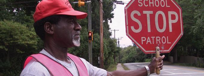
16 5. Replace the roadside post-mounted S1-1 signs (STATE LAW STOP FOR PEDESTRIAN IN CROSSWALK) with a mobile in-street pedestrian sign on Mendota Heights Road at Lockwood Drive, at the school entrance. The in-street sign is more visible to drivers and can also be moved and used at other locations as necessary. Implementation City of Mendota Heights. Existing school crossing signing on Mendota Heights Road near. Existing in-street school crossing signing on Mendota Heights Road near St. Thomas Academy. Safe Routes to School Comprehensive Plan P a g e 15

17 6. Designate a Safe Routes coordinator at the district level and each of the individual elementary and middle schools in the district, similar to the way bus transportation is currently coordinated. The district-level coordinator would share information and coordinate Safe Routes activities and best practices among all the District 197 schools. Implementation lead District Consider prioritizing plowing of trails and sidewalks that are identified as preferred walking/biking routes to school. Implementation lead City of Mendota Heights. View of the trail on the south side of Mendota Heights Road near. Long-Term Recommendations The long-term recommendations included in this section primarily consist of higher cost improvements or actions that would require a significant policy change, either of which would be expected to take longer than six months to occur. These recommendations are generally prioritized in order of importance, however funding availability may mean that the highest priority recommendations are not the first to be implemented. The infrastructure recommendations are also summarized on the Recommendations map included at the end of this report. Safe Routes to School Comprehensive Plan P a g e 16

18 1. Consider adding walking and bicycling curriculum to physical education classes and a bicycle repair shop as an after school club. Implementation lead Friendly Hills/District Investigate the feasibility of a school speed zone on Mendota Heights Road, with dynamic speed display signs that are activated only during school arrival/dismissal periods, in order to maximize their effectiveness. Implementation lead City of Mendota Heights. Example of a solar-powered driver feedback sign in a school speed zone in Anoka County. Safe Routes to School Comprehensive Plan P a g e 17


19 3. Construct a trail connection on the Friendly Hills site from the crossing at Huber Drive/Hampshire Drive to the school building. This would provide a more direct route to the school from the east, which would not have any conflicts with on-site traffic. Implementation lead District 197. Existing crosswalk at Huber Drive/Hampshire Drive. 4. Install pedestrian/bicycle wayfinding signing in the community and on the middle school site to provide improved links between the school, neighborhoods, and community destinations such as parks. Implementation lead City of Mendota Heights. Examples of bicycle wayfinding signs in Chicago (left photo) and Minneapolis (right photo). Safe Routes to School Comprehensive Plan P a g e 18

20 5. Pursue opportunities for construction of new sidewalk and trail segments, such as along Delaware Avenue, to better connect the existing trail system in Mendota Heights to surrounding communities. Sidewalk and trail construction could be completed in coordination with adjacent roadway projects or as independent projects. Implementation lead City of Mendota Heights, in cooperation with Dakota County. View of Delaware Avenue at Salem Church Road. The existing sidewalk and trail network on Mendota Heights Road, Huber Drive, and Copperfield Drive ends at Delaware Avenue. 6. Install additional bike racks when the capacity of the existing racks is reached. Implementation lead / District 197. Funding and Implementation Funding for the various recommended projects may come from a variety of sources depending on the type of project and who is implementing it. Some potential funding opportunities that currently exist and may be used to fund these recommendations include, but are not limited to: Blue Cross Blue Shield of Minnesota Mini-grants through the National Center for Safe Routes to School Federal Transportation Enhancement (TE) funds through the Metropolitan Council Safe Routes to School Comprehensive Plan P a g e 19
21 Federal Safe Routes to School funds through the Minnesota Department of Transportation. The federal Safe Routes to School program was originally funded through fiscal year 2009, but Mn/DOT currently held an infrastructure grant solicitation for Future funding beyond 2011 will be dependent on passage of the Federal Surface Transportation Reauthorization Bill, which is still being discussed in the United States Congress. The status of future funding for the Statewide Health Improvement Program (SHIP) is unknown at this time because the Minnesota Legislature has not yet established the biennial state budget and the existing funding will end on June 30, Over the past two years, SHIP funds have been administered by Dakota County Public Health in the form of Safe Routes to School grants, Active Living grants, and assistance with preparing grant applications for other programs. These funds may be available in some form in the future, and continued communications between school districts, cities, and counties will help identify opportunities and needs for funding in the future. Increased liability of the school, school district, or adult volunteers as a result of encouraging walking and biking to school is a frequent concern when implementing Safe Routes to School programs. In general, encouraging walking and biking to school does not increase the liability of the school or the district. Some tips and guidelines from the National Center for Safe Routes and the Public Health Law Center are included in the Appendix of this report as a reference. Links to additional resources such as an overall Safe Routes to School guide, walking school bus guide, and safety education materials are also provided in the Appendix. No one of the E s of Safe Routes to School will by itself increase walking and biking, which emphasizes the need for cooperation among school, city, county and other agencies. The process used to develop this plan is only the start of on-going efforts that will be needed to result in cultural changes and significant increases in walking and biking. Safe Routes to School Comprehensive Plan P a g e 20


22 LOCKWOOD DR MENDAKOTA PARK DODD RD AZTEC LN HUBER DR nm WAGON WHEEL TRL BLUEBILL DR VISITATION DR CHERI LN KRESSIN AVE CONDON CT èëì èëì 123: ALICE LN 149 PAGEL RD HAZEL CT WESTVIEW TER Mendota Heights PUEBLO DR PONDHAVEN CIR MONET CT APACHE ST MOHICAN LN KEOKUK LN DECORAH LN OCALA LN PUEBLO LN FRIENDLY HILLS MIDDLE SCHOOL BRIDGEVIEW CT ÅÆÇ ÅÆÇ ARBOR CT BUS LOADING/ UNLOADING ÅÆÇ FRIENDLY HILLS PARK nm Æó FRIENDLY MARSH PARK CHEYENNE LN APACHE CT APACHE LN PARENT PICK-UP/ DROP-OFF - PARKING LOT CONGESTION HERITAGE DR ³ ÅÆÇ ÅÆÇ :w BENT TREE LN 89:w COPPERFIELD PONDS PARK PEDESTRIAN / VEHICLE CONFLICTS ÅÆÇ SIGHT LINE CONCERNS AT CROSSINGS HAMPSHIRE DR 1239 CONCORD WAY WHITFIELD DR HAGSTROM KING PARK STONE RD COPPERFIELD DR CROSSING CONCERN - LACK OF CONNECTION TO SIDEWALK/TRAIL NETWORK 89:w HAVERTON RD POND CIR W NO TRAIL AND NARROW SHOULDERS FIELD STONE DR POND CIR E ABBEY WAY Æÿ 63 DELAWARE AVE 123; Sunfish Lake MISSING SIDEWALK/TRAIL CONNECTION KENSINGTON PARK Æÿ 63 %&'( 494 ONEILL RD C èëì Legend MUNICIPAL BOUNDARY PARK èëì TRAFFIC SIGNAL!"$ ALL-WAY STOP nm SCHOOL 1.0 MILE RADIUS AROUND SCHOOL PATH SIDEWALK ON-SITE SIDEWALK SCHOOL CROSSING ÅÆÇ 89:wÆó CROSSWALK BICYCLE RACKS LONE OAK PKY ,000 Feet Eagan LONE OAK PT NORTHWEST PKY TRINITY SCHOOL nm NORTHWEST PKWY Inver Grove Heights FRIENDLY HILLS MIDDLE SCHOOL EXISTING CONDITIONS/ISSUES


23 CYGNET LN SWAN CT WAGON WHEEL TRL BLUEBILL DR VISITATION DR CHERI LN KRESSIN AVE CONDON CT ROGERS CT èëì èëì MENDAKOTA PARK 123: ALICE LN 149 DODD RD PAGEL RD HAZEL CT WESTVIEW TER MONET CT AZTEC LN Mendota Heights PUEBLO DR PONDHAVEN CIR 3 APACHE ST MOHICAN LN KEOKUK LN DECORAH LN FRIENDLY HILLS MIDDLE SCHOOL BRIDGEVIEW CT ÅÆÇ ÅÆÇ ARBOR CT OCALA LN PUEBLO LN ÅÆÇ FRIENDLY MARSH PARK FRIENDLY HILLS PARK CHEYENNE LN APACHE LN APACHE CT :w BENT TREE LN COPPERFIELD PONDS PARK ³ 89:w 1 nm Æó ÅÆÇ 89:w ÅÆÇ ÅÆÇ 1239 HERITAGE DR 2 3 HAMPSHIRE DR WHITFIELD DR KENSINGTON PARK STONE RD HAGSTROM KING PARK HUBER DR COPPERFIELD DR HAVERTON RD POND CIR W FIELD STONE DR 3 POND CIR E ABBEY WAY Æÿ 63 DELAWARE AVE 123; Æÿ 63 Sunfish Lake %&'( 494 ONEILL RD COMM èëì Legend MUNICIPAL BOUNDARY PARK èëì TRAFFIC SIGNAL!"$ ALL-WAY STOP nm SCHOOL 1.0 MILE RADIUS AROUND SCHOOL PATH SIDEWALK ON-SITE SIDEWALK SCHOOL CROSSING ÅÆÇ 89:wÆó CROSSWALK BICYCLE RACKS LONE OAK PKY LO Feet LONE OAK PT Eagan NORTHWEST PKY AMES CROSSING RD TRINITY SCHOOL nm NORTHWEST PKWY Inver Grove Heights 1 - RESTRIPE CROSSWALKS IN PARKING LOT AND DRIVEWAY 2 - CONSIDER SCHOOL SPEED ZONE WITH DYNAMIC SPEED DISPLAY SIGNS 3 - CONSTRUCT SIDEWALK/TRAIL FRIENDLY HILLS MIDDLE SCHOOL RECOMMENDATIONS
24 Appendix
25 Safe Routes to School Comprehensive Plan Parent Survey Comments Kids bike more often in spring and fall - when they ride to school, need safe/dry place to lock bikes in case they take bus home (rainy days...). We walked every day rain or shine (rare exceptions for extreme cold) to Mendota Elementary. Crossing guards would help for middle school. Thanks. We live within walking distance of FHMS, but to get to the school, my son needs to cross a a bridge over the pond, and then cross Mendota Heights Road two times - or - he has to take the bike paths through the wooded areas. The issues I have are that the sidewalks and paths are not plowed during the winter, making them unsafe or inaccessible, and also the fact that the sidewalk on Mendota Hgts Road does not follow along both sides the entire way, also it is not plowed. Mendota Hgts Road is not safe for crossing at any of the crossing points in any weather - cars drive too fast. During summer months, the trail path is a good option for walking or biking, but again in winter, it's not walkable. We would like to be biking to school more and I would absolutely love to let my kids bike on their own -- but Friendly Hills is 4+ miles from our house and the most direct route includes two very busy highway intersections (Mendota Heights Road and Highway 55; Mendota Heights Road and Dodd/149). There's no crossing guards. There's no other families in our area interested in biking, so there's no safety in numbers, so to speak. At grade 6, there's no way I'm letting them bike on their own. Maybe when they're in 9th grade and at Henry Sibley. Maybe. My child walks or bikes to school for none of the options available. She walks because we live.7 miles away from school, I work, and it is her only option. I still think it's healthy, physically and mentally. It is a bit much in the dead of winter, though. All in all I'm glad my daughter gets the exercise. This is a difficult problem in a school district like ours that is spread over a great distance. We live over 6 miles from Friendly Hills. There is no way for us to walk or bike that distance. Why can't we have pathway and pedestrian bridge like other transit-aware first ring suburbs (see Hwy 55 in Golden Valley and others too). Although my children have walked to school, the start time of the school being later has prevented us from dropping them off rather than walking. I believe 5th grade is too young to be walking to school on their own, especially in the fall/winter when it's dark out. I'm more comfortable with walking home - As it relates to winter - It's a strain on families when the weather is cold and kids are walking home - trying to get rides home can be a challenge. We live on the other side of three major highways i.e., Highway 55, Argenta/Delaware, and Dodd/149. It is NOT safe for anyone (adult or children) to cross or walk along those roads. My son would have to cross Hwy 110 on his bike and I worry about him being hit. Off road paths and a safe intersection at Dodd and 110 would make me feel more comfortable allowing him to bike to school. Our problem is the distance and also the route to school is not the best to walk or bike rush hr is not the best for kids to walk around or bike. Traffic is a very strong issue. Also during winter is not much fun to walk.
26 I think that if a route, with safe, lit sidewalks and the absence of walking through "paths" through wooded areas where there may be more potential for a crime - abduction to take place, I would have no problem with having children over the 8th grade to walk-bike to school. That said, I think there are very few areas in the Mendota Heights area that would qualify for that... Sidewalks and lighting are crucial for having kids walk to and from school, we just don t have that around here. I am discouraged that there are no crossing guards for the kids that do walk to school, or not even a brightly colored "slow" sign to alert drivers. Delaware is dangerous. Especially South of Hwy 110. There is almost no shoulder. There is no walking or bike path. Cars go too fast. It is is straight and hilly. The most dangerous section of Delaware is between Huber and I-494. Narrow Road w/ little shoulder. Straight - nothing to slow cars down. And a big hill with a bad intersection at Salem Church Road. Friendly Hills is not the closet middle school to our house - we chose to go to FHMS vs Heritage. Based on the distance, I don't know if I would ever have my kids bike to school. In the afternoon we have no choice but to have our son walk home from school since we both work and live too close for bus service. However, in the winter the paths were not always plowed quickly and that made it VERY dangerous to walk with the busy and curvy Mendota Heights Road. Something should be done about that! I can't believe the district requires 5th graders to walk on Mendota Heights Road in the middle of winter. Traffic and distance are my prime concerns. My daughter and I live quite a long way from school (West Saint Paul) and we do not have a car. I wouldn't encourage her to ride her bike or walk to school due to the circumstances stated and also for her security it is best that she would take the school bus at any given time. My daughter attends FHMS, crossing Hwy 110 and then continuing up Delaware, which is busy in the morning and has many hills, which decreases the visibility of people walking along the side of the road. I am not comfortable allowing my daughter to ride her bike along this busy stretch of road because there are no sidewalks and people drive at least 45mph, if not faster, along Delaware. Additionally, it is not feasible to expect her to ride her bike in the heavy rain or snow, or when the temp is less than 50 degrees. We are bussed to FHMS however if there were bike paths leading to the school and safer to cross highway 110 we might consider letting our children ride their bikes some days depending on the activity. Bicycles are great - I rode a bike to school as a kid, but bike theft was a huge problem. Then again, I didn't have the heavy backpacks my kids have to carry each day, or the musical instruments on alternate days, so that's pretty limiting when it comes to bicycles. FHMS parking lot is gridlocked every afternoon with a long line of cars/drivers waiting to pick up their student(s). Left turns to go east on Mendota Heights Road from the FHMS parking lot should be prohibited in the morning and the afternoon OR the city should consider making a roundabout OR the city provide an officer to direct traffic during those peak traffic times. It is incredibly dangerous for my child to cross Mendota Heights Road in the afternoon. Yesterday a driver attempted an illegal pass Safe Routes to School Comprehensive Plan
27 around another driver stopped on the road and waiting to turn into the FHMS parking lot. In doing so, the passing driver nearly hit my child. My child has neighbors he walks with. If he were alone, I would be uncomfortable with him walking. When my daughter reaches 5th grade she won't have neighbors to walk with. I will not let her walk alone and don't know how the transportation is going to work at this time. There are no street lights, stop lights, stop signs, sidewalks, paved roads, in our area - children need to cross hwy 110 or 149 to get to a sidewalk... Walking or biking will not work in this situation. My child lives much too far from school to even consider walking or biking. Perhaps if we lived with in a few blocks and there was a group to walk with and a cell phone in her possession I would consider this an option in later years. I don't like the fact that she has to walk by herself. A lot can happen in 4 blocks from a safety/violence perspective. I worry when she walks, but she's always been ok. Distance, traffic and weather would keep me from letting my girls bike to school alone. Safe Routes to School Comprehensive Plan

28 National Center for Safe Routes to School Safe Routes to School Programs and Liability Tip Sheet For 10 Tips SafeRoutes Background and Overview Forty years ago, nearly 90 percent of children who lived close to their school walked or bicycled to get there. Today, this number has decreased by about 25 percent.1 As Safe Routes to School (SRTS) programs have developed to reverse this trend, some have wondered if encouraging walking and bicycling to school may increase a school s liability exposure. In general, the answer is no. In fact, SRTS programs are designed to help schools and communities identify and address potential safety concerns. Taking concrete steps to make walking and bicycling safer will reduce the likelihood of injury, and thereby minimize exposure to liability. A SRTS program that simply encourages or promotes bicycling and walking to school should not, in most cases, expose schools to increased liability risk. Even school-sponsored walking and bicycling programs, such as a Walking School Bus or Bicycle Train should not expose schools to any greater liability than other school-sponsored activities. Of course, schools with SRTS programs must ensure they are meeting their responsibilities for children s safety just as they must routinely do with all other forms of school transportation and with other school activities. SRTS programs can vary greatly, ranging from programs to encourage walking and bicycling to active sponsorship of walking and bicycling programs and providing new infrastructure to support these activities. The school s responsibility for safety will vary according to the individual elements of the SRTS program and the local legal context. The information below provides a brief overview of the relevant legal definitions and identifies several issues you may want to look into as you develop your program to ensure you are addressing any potential liability issues. This information is not intended as legal advice and should not be used as such. For specific legal guidance, you should consult with an attorney with relevant knowledge and experience. Legal Context Schools and school districts must regularly address issues of liability for a variety of school programs and school sponsored activities. Regardless of whether students walk, bike, take the bus, or are driven to school, there is a possibility that an injury may occur on or off school property. However, not all injuries result in liability. The extent to which a school will be held legally responsible or liable for its negligent actions or omissions depends on the facts of a given case, on laws and legal principles that vary from state to state, and even from school district to school district. In general, to establish liability for negligence, the injured person or someone acting on his or her behalf must show that the school owed a legal duty of care to that person, that the school breached that duty, and that the breach was the proximate cause of damages or injury.2 (Visit Law.com and search liability and negligence for more detailed definitions and descriptions.)

29 10 Tips Safe Routes to School Programs and Liability (continued) For A school s duty of care to students and resulting legal liability when students are injured is very situational and can only be assessed in the context of the specific program or activity and with knowledge of the specific facts giving rise to an injury. Relevant factors are likely to include: the degree to which the school controls or directs the activity that results in injury, the extent to which the school s actions conformed to applicable rules, regulations, policies, or procedures, and the extent to which the school knew or should have known of a particular hazard and failed to correct or warn against it. A school will not ordinarily be held liable for injuries sustained by children while they are walking or bicycling to school simply because the school encourages children to walk or bike, where injuries occur off school property, and parents have been reminded that the school is not responsible for supervising children who walk or bike to school. To avoid liability for negligence, the school must exercise reasonable care under the circumstances. If the school directly sponsors walking or bicycling activities such as a Walking School Bus or Bike Train, the school generally has greater responsibilities just as they would for other schoolsponsored forms of transportation. At a minimum, the school should follow the recommended procedures outlined in the National Center for SRTS publication, The Walking School Bus: Combining Safety, Fun and the Walk to School ( index.cfm) as well as any rules, policies, or protocols established by the school district for school-sponsored activities occurring off school property. (For example, volunteer training, screening, or adult to child ratios.) Minimizing Risk Even though SRTS programs are designed to make walking and bicycling safer for students, there are certain steps the school should take to minimize the risk that the school will be held liable for negligence in the event that a student is hurt while walking or bicycling to school. Some key measures are detailed below. References 1. In 1969, 87 percent of children 5 to 18 years of age who lived within one mile of school walked or bicycled to school. In 2001, 63 percent of children 5 to 18 years of age who lived within one mile of school walked or bicycled to school. U.S. Centers for Disease Control and Prevention. Kids Walk-to-School: Then and Now Barrier and Solutions. Available: Accessed: January 17, Schools Legal Service, Orange County Department of Education School Districts and School District Employees Liability for Negligence. Costa Mesa, CA.

30 10 Tips Safe Routes to School Programs and Liability (continued) For 1 the Work with your school district s administrative and legal staff to understand relevant liability issues and to develop appropriate policies. Most likely, your school district already has a number of policies in place to help manage its liability for various school programs and activities. A SRTS program is no different. You should work closely with your school district s administrative and legal staff to identify any particular risk management and insurance needs based on your individual SRTS program and the relevant laws of your jurisdiction. 2 If Be aware of local laws, regulations, and school policies. Work with your school s legal counsel to identify the laws and regulations in your jurisdiction that are relevant to walking and bicycling. These may include laws regarding school safety patrols, the designation of school walking routes (some states require them), student bus transportation, and any bicycle safety requirements such as helmets, bells or lights. You should also review the state and local pedestrian laws and portions of the local development code regarding pedestrian safety and provision of pedestrian accommodations. Make sure you are following any applicable school policies, such as parental permission slips, waivers, or required supervision for school-sponsored activities. If appropriate, your school may consider making modifications or exceptions to any school policies that appear to be in conflict with your SRTS activities. 3 4 Develop Take steps to fix problems. you are aware of unsafe walking and bicycling conditions, such as unsafe vehicle drop off and pick up conditions, take steps to fix them. Even if the problem is not subject to the school s control, such as a heavily trafficked local street, the school should warn parents of any known hazards, and take any prudent steps to address conditions under the school s control that might exacerbate the risk of injury. Be proactive. a plan. Developing a SRTS Plan for an individual school is a great way to identify potential safety problems and prioritize needed improvements. If you identify problems, take steps to address the problems and inform the school community of possible hazards that cannot be or have not yet been corrected. 5 Document your efforts. If you are aware of potential problems, document your efforts to fix them. For example, if you are made aware of problems with speeding vehicles in the school area, keep records of your communication with law enforcement officials to address the problem and your communications to parents warning them of any uncorrected problems.
31 10 Tips Safe Routes to School Programs and Liability (continued) For 6 Parents 8 Be uniform, systematic and consistent in undertaking safety improvements. In making improvements such as new sidewalks or improved crossings, follow accepted engineering and design practices. Any design exceptions should be carefully reviewed so as not to compromise safety. Consider waivers. Where a SRTS program sponsors specific transportation activities, such as a walking school bus or bicycle train, a school may decide to require parent volunteers and parents of student participants to sign waivers or permission slips acknowledging that the participants are assuming the risk of injury by engaging in walking and bicycling activities, and waiving any claims against the school for its negligent acts or omissions. Keep in mind that waivers need to be carefully drafted in order to be effective. 7 Inform and involve parents. and designated caretakers are ultimately responsible for deciding how their children get to school. Material promoting SRTS programs should make clear that parents should determine their child s readiness and the best route for walking and bicycling. Encourage parents to accompany younger children. Let parents know the location of signalized or marked crossings and locations with crossing guards and recommend that they use them. Provide pedestrian and bicycle safety tips to parents as well as students. (See safety tip sheets at the National Center s Web site at resources/education_tip-sheets.cfm) 9 Make Obtain adequate insurance coverage for your program. Your school district is likely to have a large umbrella policy that covers a range of school programs and school sponsored activities. Review this policy to ensure the SRTS activities you are organizing are covered. If they are not, have the policy adjusted to include these activities. 10 Provide training. sure crossing guards and school employees working on traffic and safety issues are well trained regarding pedestrian and bicycle safety and their responsibilities for ensuring that children are safe on their journey to and from school. Provide training to volunteers, and if appropriate, screening, where volunteers will be supervising children as part of a SRTS activity, such as a formal Walking School Bus or Bike Train. SafeRoutes National Center for Safe Routes to School For more resources and information on Safe Routes to School, please visit the National Center for Safe Routes to School Web site at


32 ` LIABILITY FOR VOLUNTEERS IN THE WALKING SCHOOL BUS PROGRAM A Walking School Bus Program aims to get children walking to and from school in groups accompanied by adults. It encourages students and adults to be more physically active and social. The program is ideal for neighborhoods that have a school within walking distance. Adult volunteers are essential to the Walking School Bus Program. They are responsible for organizing the program and for walking the children to and from school. Adult volunteers are expected to act responsibly just as they would with their own children. Provided that adult volunteers act reasonably and with good intention, a Minnesota statute will protect them from liability claims for accidents that occur during the course of volunteering. Q: What is liability? A: Put simply, liability is a legal responsibility. Typically, for you to be held liable, someone must prove that: You owed them a duty of care; You failed to perform that duty or did so negligently; and Your negligence caused someone harm that could have reasonably been expected to occur. Q: What is a person s duty of care? A: The duty you owe someone depends on the circumstances. Generally, everyone has the duty to act with reasonable care toward others. What is considered reasonable also depends on the circumstances. Q: What is negligence? A: Negligence is the failure to act as carefully as an ordinary, reasonable person would in the same situation. Q: What is cause of harm? A: Cause of harm means that your action was an important factor in causing the harm and that you could have reasonably expected the injury to occur. Q: Are there any Minnesota laws that provide added protection to volunteers? A: Yes. Under a Minnesota law, volunteers will generally not be liable for a child s injuries if their actions (1) were in good faith, (2) within the scope of their duties, and (3) not willful or reckless.

33 Q: What does acting in good faith mean? A: This means acting with a good, honest intention or belief. Good Faith: A volunteer takes the children down a different route one day, believing the traffic will be lighter. The traffic is actually heavier, and a car hits a child while he is crossing the road in a crosswalk. Not Good Faith: A child misbehaves during the walk. The volunteer makes the child walk home by himself, knowing that the child does not know the way home. The child gets lost and is injured. Q: What does acting within the scope of their duties mean? A: This means acting according to one s role or responsibilities as a volunteer. Within the Scope of Duties: A student slips and is injured while the volunteer is walking the student to school. Not Within Scope of Duties: After school, a student stays over at a volunteer s house to play with the volunteer s children. The student slips and is injured. Q: What is willful or reckless conduct? A: This means acting with disregard for the safety of others, or failing to act with ordinary care to prevent or discover a danger. Some examples of willful or reckless conduct might include: telling a child to run across the street when the light is red; telling children to cross the road without looking both ways; or making children walk long distances in extreme heat without water. Q: If I am sued, will insurance cover the costs of the litigation? A: Check the terms of your homeowner s or renter s insurance policy to learn what is covered. Typically, insurance consists of two parts property coverage and personal liability coverage. The personal liability portion of the policy may protect against a lawsuit brought by someone who is injured by something you do. It will pay for damages or medical expenses if you are responsible for the injury. Also, it will pay for legal expenses to defend you if the lawsuit is unjustified. Q: How can Walking School Bus Program volunteers reduce the risk of liability? A: Common sense precautions go a long way toward avoiding liability risk. Most importantly, a parent volunteer should act like an ordinary, reasonable person. Additional steps could be: Creating safety rules and handing them out to all students and parents. These safety rules should comply with any local school rules. Planning a training day for students and volunteers. Wearing fluorescent vests while walking with the children. Asking the parents or guardians to sign a waiver saying they will not hold you liable for any injuries. (Please refer to the Public Health Law Center s Waivers and Releases Fact Sheet.) Eliminating dangers, where possible. Having one adult volunteer for every six children over the age of 10 and one adult volunteer per three children for four to six year-olds. Documenting all precautions taken to avoid harm or risk. For related publications, visit Click on Publications and Resources link and then on Fact Sheets. The Public Health Law Center provides information and technical assistance on issues related to tobacco and public health. The Public Health Law Center does not provide legal representation or advice. This document should not be considered legal advice. For specific legal questions, consult with an attorney. Contact the Public Health Law Center for citations used in this factsheet. Updated July 2010.

 practitioners get these students excited about Safe Routes to School?")
34 Tips FOR Engaging Middle School Students in Safe Routes to School Programs SafeRoutes National Center for Safe Routes to School Tip Sheet Middle school students are very energetic and curious and yet engaging them can be a challenge. They have a new level of independence when it comes to walking and bicycling to school compared to when they were younger, but may be reluctant to take advantage of it because they think it uncool. They may also resist walking and bicycling safety advice from adults. How can Safe Routes to School (SRTS) practitioners get these students excited about Safe Routes to School? The secret lies in recognizing and building off of the typical attributes of middle school students: A desire for self-expression and self-determination A preference for hands-on learning that is personally relevant An expanding awareness of social, cultural, and environmental issues A growing concern for peer approval A sense of awkwardness and self-consciousness associated with the onset of puberty The following tips offer ways to use these attributes to engage students in a Safe Routes program. In most cases, these ideas require coordination with the school, so it is a good idea to discuss options with administrators and teachers before getting started. Students at Hall Middle School in Marin County, California prepare to take the stage for a school assembly on the benefits of green transportation that they helped plan. Tip 1 Provide opportunities for self-expression and self-determination. Ask students to design logos, posters, computer animations, and web sites with SRTS messages. Put students in charge of planning SRTS-related activities, such as assemblies, fundraisers and publicity campaigns. Tip 2 Create hands-on learning experiences that are personally relevant. Ask students to identify locations where changes like sidewalks or crossing guards would improve walking conditions using GPS devices, digital cameras or checklists for assessing walkability and bikeability. Middle school students use portable computers, digital cameras, and GPS devices to identify blighted properties and other safety concerns around their schools as part of the Mapping Out a Safer Community Program in Detroit, Michigan. Establish a build-a-bike program, where students can learn about bicycle repair, maintenance, and safety by fixing up used or donated bikes, which they then get to keep. Encourage students to voice their need for improved walking and biking conditions. Suggest a presentation at a public meeting or a letter writing campaign to local decision-makers.

35 Tips For Engaging Middle School Students in Safe Routes to School Programs (continued) Tip 3 Highlight the connection between SRTS and social, cultural, or environmental issues that may be important to students. Organize lessons, activities, and events about climate change and the benefits of walking or bicycling for transportation. Invite local sports personalities to talk about how walking and biking to school promotes physical fitness and health. Tip 4 Foster positive interactions between middle school students and their peers and provide opportunities for peer identification and acceptance. Start a club with a mission that ties into SRTS, such an after-school bicycling or environmental club. Plan events that emphasize fun but also deliver relevant SRTS messages, such as a Walk to School Day or Walk and Roll Day celebrating walking and biking to school. Develop a cross-age teaching program, where older students teach bicycle and pedestrian safety skills to younger students. High-school students can be recruited to teach middle school students and middle school students might decide to teach elementary school kids. Alexandria, Virginia s Junior Bicycle Ambassadors demonstrate a turn signal during a Bicycle Rodeo at Hammond Middle School. Tip 5 Be sensitive to the vulnerability, awkwardness, and self-consciousness that often accompany the middle school years. Avoid putting middle school students in situations where they may be exposed to ridicule or embarrassment, such as contests that identify losers on an individual basis or where students are allowed to choose teams. Be extremely sensitive when addressing the issue of obesity. SafeRoutes National Center for Safe Routes to School For more resources and information on Safe Routes to School, please visit the National Center for Safe Routes to School Web site at


36 Safe Routes to School guide saferoutesinfo.org


37


38 SafeRoutes National Center for Safe Routes to School

39
Safe Routes to School Comprehensive Plan
 Safe Routes to School Comprehensive Plan City of Apple Valley Dakota County, MN May 2010 Prepared by: Project Background The Statewide Health Improvement Program (SHIP) aims to help Minnesotans live longer,
Safe Routes to School Comprehensive Plan
 Safe Routes to School Comprehensive Plan City of Rosemount Dakota County, MN June 2010 Prepared by: Project Background The Statewide Health Improvement Program (SHIP) aims to help Minnesotans live longer,
Safe Routes to School Comprehensive Plan
 Safe Routes to School Comprehensive Plan City of South St. Paul Dakota County, MN December 2010 Prepared by: Project Background The Statewide Health Improvement Program (SHIP) aims to help Minnesotans
SAFE ROUTES TO SCHOOL
 SAFE ROUTES TO SCHOOL Edgewood Elementary School Existing Conditions and ACTION PLAN > Oak Creek - Franklin Joint School District Table of Contents CONTEXT Enrollment Boundaries Enrollment
Safe Routes to School Comprehensive Plan
 Safe Routes to School Comprehensive Plan City of Rosemount Dakota County, MN June 2010 Prepared by: Project Background The Statewide Health Improvement Program (SHIP) aims to help Minnesotans live longer,
Bringing together community and health. Physical Activity and Nutrition Unit Office of Statewide Health Improvement Initiatives
 Bringing together community and health. Physical Activity and Nutrition Unit Office of Statewide Health Improvement Initiatives Physical Activity and Nutrition Unit Office of Statewide Health Improvement
SAFE ROUTES TO SCHOOL
 SAFE ROUTES TO SCHOOL Forest Ridge Elementary School Existing Conditions and ACTION PLAN > Oak Creek - Franklin Joint School District Table of Contents CONTEXT Enrollment Boundaries
Safe Routes to School Comprehensive Plan
 Safe Routes to School Comprehensive Plan City of Hastings Dakota County, MN December 2010 Prepared by: Project Background The Statewide Health Improvement Program (SHIP) aims to help Minnesotans live longer,
Vallecito Elementary School. Travel Plan
 Vallecito Elementary School Travel Plan TABLE OF CONTENTS 1. PURPOSE... 1 1.1. SR2S PLANNING, IMPLEMENTATION AND MONITORING... 1 1.2. MARIN COUNTY MEASURE A... 1 2. VALLECITO ELEMENTARY SCHOOL PROFILE...
July 5, Arthur R. Ware, Jr. Elementary School 2017 Safe Routes to School Walkabout Report
 July 5, 2017 Arthur R. Ware, Jr. Elementary School 2017 Safe Routes to School Walkabout Report 1 Walkabout Report Introduction On April 28, 2017, City, School, and SAWMPO staff met to conduct a Safe Routes
Aitkin School Routing Plan July 2010
 Aitkin School Routing Plan July 2010 Prepared by: Arrowhead Regional Development Commission Regional Planning Division Aitkin School Routing Plan July 2010 Aitkin School Routing Plan July 2010 Prepared
Parent Survey Report: One School in One Data Collection Period
 Parent Survey Report: One School in One Data Collection Period School Name: Broken Arrow Elementary School Set ID: 12172 School Group: Douglas County Month and Year Collected: October 2014 School Enrollment:
Double the amount of bicycle ridership while at the same time reducing the number of bicycle crashes by one-third.
 CHAPTER 6 Recommended Policies and Action Items To achieve the goals stated in Chapter 1 and guide implementation of the Bicycle Plan, policies and action items have been identified. They are presented
Parent Survey Report: One School in One Data Collection Period
 Parent Survey Report: One School in One Data Collection Period School Name: Bilquist Elementary School Set ID: 15803 School Group: Clackamas County Month and Year Collected: December 2016 School Enrollment:
CITY OF OAK CREEK SAFE ROUTES TO SCHOOL ACTION PLAN. East Middle School
 CITY OF OAK CREEK SAFE ROUTES TO SCHOOL ACTION PLAN East Middle School CITY OF OAK CREEK SAFE ROUTES TO SCHOOL ACTION PLAN East Middle School Why Safe Routes to School? Safe Routes to School ( SRTS ) is
Chapter 3.9 Timbercrest Elementary School. Volusia County MPO. November 2008
 Chapter 3.9 Timbercrest Elementary School Deltona, FL Volusia County MPO November 2008 Volusia County MPO School Bicycle and Pedestrian Review Study, Phase 3B School Summary Timbercrest Elementary School
2 Mark Twain Elementary School Report
 2 Mark Twain Elementary School Report Principal: Greg Kaatz Grades: K-2 Enrollment: 323 Address: 425 N. Church Street First bell: 8:10 a.m. Silverton, OR 97381 Last bell: 2:30 p.m. Free & Reduced Lunch:
Summary Report School Walking & Bicycling Audits. Mesa County Regional Transportation Planning Office
 Summary Report School Walking & Bicycling Audits Mesa County Regional Transportation Planning Office This page left blank intentionally WALKING & BICYCLING AUDIT SUMMARY 2 Executive Summary Background:
About the Studio. Edward J. Bloustein School of Planning and Public Policy - Rutgers University
 About the Studio Edward J. Bloustein School of Planning and Public Policy - Rutgers University Purpose of studio: Help City of Bayonne apply for Safe Routes to School (SRTS) funding by producing a School
S A F E R O U T E S T O S C H O O L H E R M A N TOW N S C H O O L S A N D P R O C TO R S C H O O L S P L A N A P P R OVA L S
 S A F E R O U T E S T O S C H O O L H E R M A N TOW N S C H O O L S A N D P R O C TO R S C H O O L S P L A N A P P R OVA L S WHAT IS SAFE ROUTES TO SCHOOL? In 1969, nearly 50% of children walked or rode
Bicycle Master Plan Goals, Strategies, and Policies
 Bicycle Master Plan Goals, Strategies, and Policies Mobilizing 5 This chapter outlines the overarching goals, action statements, and action items Long Beach will take in order to achieve its vision of
Madison Urban Area and Dane County. Bicycle Transportation Plan Summary. September Introduction. Bicycle Plan Scope and Planning Process
 Bicycle Transportation Plan Summary Madison Urban Area and Dane County Introduction September 2000 Bicycling is an important mode of transportation in the Madison urban area and countywide that is available
Chapter 2. Bellingham Bicycle Master Plan Chapter 2: Policies and Actions
 Chapter 2 Bellingham Bicycle Master Plan Chapter 2: Policies and Actions Chapter 2: Policies and Actions The Bicycle Master Plan provides a road map for making bicycling in Bellingham a viable transportation
CITY OF BLOOMINGTON COMPLETE STREETS POLICY
 CITY OF BLOOMINGTON COMPLETE STREETS POLICY POLICY OBJECTIVE: The City of Bloomington will enhance safety, mobility, accessibility and convenience for transportation network users of all ages and abilities,
AGENDA. 5. Next Steps a. Survey Distribution b. Draft Action Plan/Recommendations c. Review at next meeting in advance of document preparation
 Congdon Elementary Safe Routes to School Plan Update SRTS Team Meeting #2-Walk Audit March 21, 2018, 3:00 p.m. Congdon Elementary School Art Room-Duluth, MN 1. Welcome and Introductions 2. SRTS Review
Chapter 5. Complete Streets and Walkable Communities.
 Chapter 5. Complete Streets and Walkable Communities. 5.1 Description of Complete Streets. Cities throughout the world, and specifically the United States, are coming to embrace a new transportation and
SRTS Programs That Increase Walking and Bicycling to School
 Getting Results: SRTS Programs That Increase Walking and Bicycling to School SafeRoutes National Center for Safe Routes to School Communities initiate Safe Routes to School (SRTS) programs for a variety
Safe Routes to School Guide
 Safe Routes to School Guide Steps to Creating a Safe Routes to School Program Created February 2007 SafeRoutes National Center for Safe Routes to School This guide was developed by the Pedestrian and Bicycle
Safe Routes to School Action Plan Aberdeen, Idaho
 Background Aberdeen, Idaho is a largely agricultural community of nearly 2,000 people and is located in the southeast portion of the state on the western edge of American Falls Reservoir. The community
TOWN OF PORTLAND, CONNECTICUT COMPLETE STREETS POLICY
 TOWN OF PORTLAND, CONNECTICUT COMPLETE STREETS POLICY I. VISION, GOALS & PRINCIPLES VISION To improve the streets of Portland making them safer and more accessible for all users including pedestrians,
City of Ann Arbor Pedestrian Safety & Access Task Force
 City of Ann Arbor Pedestrian Safety & Access Task Force (PSATF) Community Wide Meeting Wednesday, July 8th 6:30 to 8:30 PM Multi purpose Room, Downtown Library www.a2gov.org/pedsafety The Greenway Collaborative,
Parent Survey Report: One School in One Data Collection Period
 Parent Survey Report: One School in One Data Collection Period School Name: Pinckney Elementary School Set ID: 12170 School Group: Douglas County Month and Year Collected: October 2014 School Enrollment:
3 Silverton High School Report
 3 Silverton High School Report Principal: Justin Lieuallen Grades: 9-12 Enrollment: 1,277 Address: 1456 Pine Street First bell: 7:55 a.m. Silverton, OR 97381 Last bell: 3:05 p.m. Free & Reduced Lunch:
Hennepin County Bicycle and Pedestrian Planning
 Hennepin County Bicycle and Pedestrian Planning 1 Value of bicycle and sidewalk systems Safety Livability Mobility Health Personal Finances Economic Sustainability Clean Air Recreation Parking and congestion
C/CAG. Sunnybrae Elementary School Walking and Bicycling Audit. San Mateo-Foster City School District JUNE 2013
 Sunnybrae Elementary School Walking and Bicycling Audit JUNE 2013 San Mateo-Foster City School District C/CAG City/County Association of Governments of San Mateo County SUNNYBRAE ELEMENTARY SCHOOL WALKING
City of Novi Non-Motorized Master Plan 2011 Executive Summary
 City of Novi Non-Motorized Master Plan 2011 Executive Summary Prepared by: February 28, 2011 Why Plan? Encouraging healthy, active lifestyles through pathway and sidewalk connectivity has been a focus
Safe Routes to School NELLIE STONE JOHNSON COMMUNITY SCHOOL
 December 2010 Safe Routes to School NELLIE STONE JOHNSON COMMUNITY SCHOOL Encouraging walking and biking to school Safe Routes to School: Healthy Kids Focused Students Across the nation, communities are
SPARE THE AIR YOUTH SCHOOLPOOL
 SPARE THE AIR YOUTH SCHOOLPOOL GUIDEBOOK Sharing the trip to school with Walking School Buses, Bike Trains, and Carpools JULY 2014 1 SCHOOLPOOL GUIDEBOOK 01 INTRODUCTION Spare the Air Youth is a regional
SAFE ROUTES TO SCHOOL
 CITY OF LOS ANGELES WALKING ACTIVITY HANDBOOK LOS ANGELES UNIFIED SCHOOL DISTRICT CITY OF LOS ANGELES DEPARTMENT OF TRANSPORTATION LOS ANGELES CITYWIDE WALK TO SCHOOL ORGANIZER MANUAL SAFE ROUTES TO SCHOOL
National Safe Routes to School Program: Initial Results
 National Safe Routes to School Program: Initial Results Lauren Marchetti National Center for Safe Routes to School 9 th Annual New Partners for Smart Growth Thursday, February 4, 2010 Seattle, WA August
EXECUTIVE SUMMARY. Vision
 Vision Walking and bicycling in Salt Lake City will be safe, convenient, comfortable, and viable transportation options that connect people to places, foster recreational and economic development opportunities,
Why Zone In on Speed Reduction?
 Learn it. Do it. Live it! SPEED REDUCTION IN THE ZONE Why Zone In on Speed Reduction? Speeding is a serious issue that plays a major role in the risk of serious injury and pedestrian fatality in a crash.
NM-POLICY 1: Improve service levels, participation, and options for non-motorized transportation modes throughout the County.
 Transportation PRINCE WILLIAM COUNTY 2008 COMPREHENSIVE PLAN NON-MOTORIZED PLAN CONTENTS Goals, Policies, and Action Strategies Table 4 (Bike Facility Classifications and Descriptions) Table 5 (Bike Facility
PEDESTRIAN ACTION PLAN
 ATTACHMENT 2 CITY OF SANTA MONICA PEDESTRIAN ACTION PLAN CITY OF SANTA MONICA PEDESTRIAN ACTION PLAN This page intentionally left blank EXECUTIVE SUMMARY CHAPTER 1 EXECUTIVE SUMMARY Setting the Stage
NEIGHBORHOOD TRAFFIC CALMING POLICY
 NEIGHBORHOOD TRAFFIC CALMING POLICY I. PURPOSE The City of Kent continually strives to strengthen and protect its neighborhoods by improving the quality of life in residential areas. Traffic conditions
City of Coronado Bicycle Map, Schools, Traffic Signals and Crossing Guard Locations
 City of Coronado Bicycle Map, Schools, Traffic Signals and Crossing Guard Locations Early Childhood Development Center Crossing Guard - AM Crossing Guard - PM Coronado Middle Village Elementary Coronado
Randolph-Hamline ( Ran-Ham ) Area Safe Routes to School Plan
 Area Safe Routes to School Plan") Randolph-Hamline ( Ran-Ham ) Area Safe Routes to School Plan Cretin Derham Hall Expo Elementary Holy Spirit Elementary Randolph Heights Elementary Saint Paul, Minnesota September 2016 Prepared By: Saint
Randolph-Hamline ( Ran-Ham ) Area Safe Routes to School Plan Cretin Derham Hall Expo Elementary Holy Spirit Elementary Randolph Heights Elementary Saint Paul, Minnesota September 2016 Prepared By: Saint
Wellington Exempted Village School District SAFE ROUTES TO SCHOOL TRAVEL PLAN January 2014
 Wellington Exempted Village School District SAFE ROUTES TO SCHOOL TRAVEL PLAN January 2014 OHIO SAFE ROUTES TO SCHOOL WELLINGTON EXEMPTED VILLAGE SCHOOL DISTRICT TRAVEL PLAN SECTION 1: WELLINGTON EXEMPTED
Safe Routes to School
 Safe Routes to School Amy Paxton-Aiken, Center TRT University of North Carolina Chapel Hill, NC and Ian Thomas, Executive Director PedNet Coalition Columbia, MO Housekeeping If you are calling in on a
School Bicycling and Walking Policies: Addressing Policies that Hinder and Implementing Policies that Help
 School Bicycling and Walking Policies: Addressing Policies that Hinder and Implementing Policies that Help Tip Sheet As key partners in Safe Routes to School (SRTS) programs, schools and school districts
RESOLUTION NO ?? A RESOLUTION OF THE CITY OF NEPTUNE BEACH ADOPTING A COMPLETE STREETS POLICY
 RESOLUTION NO. 2018-?? A RESOLUTION OF THE CITY OF NEPTUNE BEACH ADOPTING A COMPLETE STREETS POLICY WHEREAS, safe, convenient, and accessible transportation for all users is a priority of the City of Neptune
Drag and drop pic and stretch/crop to the limits of the blue rectangle (delete this text box) Maxey Elementary School
 Maxey Elementary School") Drag and drop pic and stretch/crop to the limits of the blue rectangle (delete this text box) Maxey Elementary School SCHOOL ROUTE PLAN For MAXEY ELEMENTARY SCHOOL LOCATION 33 ORANGE COUNTY Prepared for:
Drag and drop pic and stretch/crop to the limits of the blue rectangle (delete this text box) Maxey Elementary School SCHOOL ROUTE PLAN For MAXEY ELEMENTARY SCHOOL LOCATION 33 ORANGE COUNTY Prepared for:
Proposed. City of Grand Junction Complete Streets Policy. Exhibit 10
 Proposed City of Grand Junction Complete Streets Policy Exhibit 10 1 City of Grand Junction Complete Streets Policy Vision: The Complete Streets Vision is to develop a safe, efficient, and reliable travel
APPROVE A RESOLUTION ADOPTING A COMPLETE STREETS POLICY
 STAFF REPORT MEETING DATE: September 13, 2016 TO: FROM: City Council Bob Brown, Community Development Director Russ Thompson, Public Works Director Patrick Filipelli, Management Analyst 922 Machin Avenue
o n - m o t o r i z e d transportation is an overlooked element that can greatly enhance the overall quality of life for the community s residents.
 N o n - m o t o r i z e d transportation is an overlooked element that can greatly enhance the overall quality of life for the community s residents. 84 Transportation CHAPTER 11 INTRODUCTION Transportation
Sebastopol Charter School Traffic Management Plan
 Sebastopol Charter School The serves as the working document in support of these essential goals: to ensure the safety and efficiency of student arrival to and departure from school to ensure the safety
Memorandum. Public Comments
 711 SE Grand Ave. Portland, OR 97214 (503) 230-9862 www.altaplanning.com Memorandum Date: November 30, 2016 To: From: Re: City of Tacoma Hannah Day-Kapell and Gena Gastaldi, Alta Planning + Design Tacoma
Speed Limits Study and Proposal. Public Input Session: 8/14/13
 Speed Limits Study and Proposal Public Input Session: 8/14/13 Why is Decatur a unique place for this project? First Community Transportation Plan in the nation with a Health Impact Assessment. Strong sense
BIKE PLAN CONTENTS GATEWAY
 CONTENTS Acknowledgments...vii Great Rivers Greenway District Board of Directors... vii Great Rivers Greenway District Staff... vii Project Consultants... vii Committees... viii Citizens Advisory Committee
Get Oregon kids. Walking, biking and rolling to school planning guide
 Get Oregon kids Walking, biking and rolling to school planning guide The Oregon Health Authority produced this guide with assistance from the Oregon Department of Education, Oregon Department of Transportation
Safe Routes to School Travel Plan 2011
 Safe Routes to School Travel Plan 2011 Barley Sheaf Elementary School Barley Sheaf School 80 Barley Sheaf Road Flemington, NJ 08822 Grades: K-4 Introduction Barley Sheaf School is a K-4 elementary school
Active Transportation Infrastructure Investment A Business Case
 Active Transportation Infrastructure Investment A Business Case In 2016, the Real Estate Foundation awarded the Capital Regional District a $50,000 grant for Shifting Gears: Land Use Change through Active
Agenda. Overview PRINCE GEORGE S PLAZA METRO AREA PEDESTRIAN PLAN
 PRINCE GEORGE S PLAZA METRO AREA PEDESTRIAN PLAN May 28, 2008 Agenda Welcome and introductions Project overview and issue identification Planning context and strengths Design challenges and initial recommendations
The Florida Bicycle and Pedestrian Partnership Council
 The Florida Bicycle and Pedestrian Partnership Council Input to the Update of the Florida Transportation Plan March 2015 This document presents input from the Florida Bicycle and Pedestrian Advisory Council
Solana Beach Comprehensive Active Transportation Strategy (CATS)
") Solana Beach Comprehensive Active Transportation Strategy (CATS) 3.0 Goals & Policies The Solana Beach CATS goals and objectives outlined below were largely drawn from the Solana Beach Circulation Element
Solana Beach Comprehensive Active Transportation Strategy (CATS) 3.0 Goals & Policies The Solana Beach CATS goals and objectives outlined below were largely drawn from the Solana Beach Circulation Element
THE OFFICIAL GUIDE TO CYCLING SAFELY IN PHILADELPHIA
 B IKE NICE THE OFFICIAL GUIDE TO CYCLING SAFELY IN PHILADELPHIA A partnership of the City of Philadelphia and the Bicycle Coalition of Greater Philadelphia ABOUT VISION ZERO & BIKE NICE It s a great day
DRAFT. Table of Contents. Background
 Douglas County Table of Contents Existing Infrastructure 86 Funding 89 Policy and Program Recommendations 90 Infrastructure Recommendations 92 Conclusion 95 Background Home to 4,500 residents and Baker
Prioritizing Schools for Safe Routes to School Infrastructure Projects
 Prioritizing Schools for Safe Routes to School Infrastructure Projects Determining the most effective use of limited infrastructure funds is a challenging task. It is especially demanding for local transportation
Woodward Hill Elementary School School Safety and Operation Review
 Address: 6082-142 nd Street Surrey, BC, V3X 1C1 Site Visit: March 7, 2011 Principal Anne Mackie Report Date: November 25, 2011 Phone: (604) 594-2408 Email: Mackie_A@sd36.bc.ca The following report is one
Middle School Walk Audit Booklet
 Safe Routes to School GEORGIA Georgia Department of Transportation Middle School Walk Audit Booklet This Walk Audit Guide was prepared by the Georgia Safe Routes to School Resource Center, funded by the
SCHOOL CROSSING PROTECTION CRITERIA
 CITY OF MADISON TRAFFIC ENGINEERING SCHOOL CROSSING PROTECTION CRITERIA January 2016 Adopted as Policy on August 31, 1976, by Common Council by Amended Resolution #29,540 Amended on September 14, 1976,
Arlington Public Schools Thomas Jefferson Site Evaluation Transportation Networks. Thomas Jefferson Working Group Meeting #6 November 10, 2014
 Arlington Public Schools Thomas Jefferson Site Evaluation Transportation Networks Thomas Jefferson Working Group Meeting #6 November 10, 2014 2 3 INTRODUCTION 4 Goal of our work: Identify and assess multi-modal
CITY OF KASSON TRANSPORTATION ALTERNATIVES KASSON SAFE ROUTES TO SCHOOL
 ve ha 8t G B A Mantorville Ave N 240th Ave 16th St NE 11th Ave NE K-M HIGH SCHOOL SUNRISE TRAIL TO MANTORVILLE MNTH 57 SUNSET TRAIL TO MANTORVILLE NE PARK 16TH ST NE TRAIL K-M ELEMENTARY SCHOOL K-M MIDDLE
City of Wayzata Comprehensive Plan 2030 Transportation Chapter: Appendix A
 A1. Functional Classification Table A-1 illustrates the Metropolitan Council s detailed criteria established for the functional classification of roadways within the Twin Cities Metropolitan Area. Table
MARKET/JFK VISION ZERO PILOT PROJECT FEBRUARY 2019 EVALUATION REPORT
 MARKET/JFK VISION ZERO PILOT PROJECT FEBRUARY 2019 EVALUATION REPORT WHY IS THIS PROJECT IMPORTANT? Market Street and JFK Boulevard in Center City are key east-west corridors in the core business district.
Implementing the Three Es of School Zone Traffic Calming
 Implementing the Three Es of School Zone Traffic Calming Use this evaluation tool as a guide to analyze the specific safety needs of your school. SCHOOL PROFILE School Name: School District: Address: Phone
City of Davis East Covell Corridor Plan
 Community Open House #2 January 22, 2014 6:00 8:00 p.m. Veterans Memorial Center, Club Room City of Davis Introduction The (ECCP) is a taking a comprehensive look at the existing transportation systems
Perryville TOD and Greenway Plan
 Perryville TOD and Greenway Plan Greenway Glossary Pathway: A bicycle and pedestrian path separated from motorized vehicular traffic by an open space, barrier or curb. Multi-use paths may be within the
Safe Routes to School
 Safe Routes to School Survey Results of Students in Breckenridge, Minnesota North Dakota State Data Center at North Dakota State University, an Equal Opportunity Ins tu on October 2010 h p://www.ndsu.edu/sdc/publica
Lake Whitney Elementary School
 Lake Whitney Elementary School SCHOOL ROUTE PLAN For LAKE WHITNEY ELEMENTARY SCHOOL LOCATION 18 ORANGE COUNTY Prepared for: ORANGE COUNTY SCHOOL ASSESSMENT PROGRAM ORANGE COUNTY PUBLIC WORKS Traffic Engineering
Hedgepeth Williams Middle School and Paul Robeson Elementary School Trenton, NJ. School Travel Plan
 Hedgepeth Williams Middle School and Paul Robeson Elementary School Trenton, NJ School Travel Plan Hedgepeth Williams Middle School Description: Hedgepeth-Williams Middle School is located at 301 Gladstone
Streets. Safe for Pedestrians 20% 2nd 5,000. Are We People-Friendly?
 Streets Safe for Pedestrians 20% Pedestrian deaths account for more than of all traffic-related fatalities in California each year. 600 More than people are killed and another 13,000 are injured every
City of Elizabeth City Neighborhood Traffic Calming Policy and Guidelines
 City of Elizabeth City Neighborhood Traffic Calming Policy and Guidelines I. Purpose: The City of Elizabeth City is committed to ensure the overall safety and livability of residential neighborhoods. One
Non-Motorized Transportation 7-1
 Non-Motorized Transportation 7-1 Transportation facilities no longer mean just accommodating a vehicle powered by a combustion engine. Pedestrian and non-motorized facilities are important modes of travel
Introduction.
 2307-1.0. Introduction. Delaware s Safe Routes to School (SRTS) Program was established September 10, 2002 when Governor Ruth Ann Minner signed Senate Bill 353 of the 141st General Assembly of Delaware
GUIDEBOOK Version
 GUIDEBOOK Version 4. 2010 alk&âoll to Íchool Îays Table of Contents Introduction... 3 How to establish a weekly Walk and Roll to School Day at your elementary school... 4 Words of Wisdom from a Team Leader...
FELL STREET AND MASONIC AVENUE INTERSECTION SURVEY REPORT
 FELL STREET AND MASONIC AVENUE INTERSECTION SURVEY REPORT City and County of San Francisco Municipal Transportation Agency Bicycle Program October 2005 Background The intersection of Fell Street with Masonic
Lee s Summit Road Improvement Study Public Open House June 7, 2007 Summary of Comment Card Responses
 Lee s Summit Road Improvement Study Public Open House June 7, 2007 Summary of Comment Card Responses Introduction At the Lee s Summit Road Improvement Study Public Open House held Thursday, June 7, 2007
Walk Friendly Communities Education and Encouragement Programs
 Walk Friendly Communities Programs Dan Gelinne Walk Friendly Communities Workshop Grandview, MO June 2015 Module Overview Topics Background and purpose What is the role of education and encouragement programs?
Bike To School Day Resource Guide 2012
 Bike To School Day Resource Guide 2012 TABLE OF CONTENTS Brief History of Bike to School Day... 3 Introduction... 5 Why Bike To School?... 5 Suggested Activities for Bike to School Day... 7 Bike To School
WALK- AND bike-friendly TURLOCK
 WALK- AND bike-friendly TURLOCK Ideas to Encourage Walking and Biking Benefits to the COMMUNITY Get Connected People who walk and bike have many more opportunities for casual interactions with friends
Meadow Woods Elementary School
 Drag and drop pic and stretch/crop to the limits of the blue rectangle (delete this text box) Meadow Woods Elementary School Drag and drop pic and stretch/crop to the limits of the blue rectangle (delete
Mayor s Bicycle Advisory Council. Wednesday, December 13 th, 2017
 Mayor s Bicycle Advisory Council Wednesday, December 13 th, 2017 Bicyclist Fatalities, Year to Date (January 1 November 30, 2017) - MBAC Briefing Bicyclist Fatality Statistics Year to date total, 2017
Chapter 4.3 Enterprise Elementary. Volusia County MPO. March Page 7.0
 Chapter 4.3 Enterprise Elementary Enterprise, FL Volusia County MPO March 2008 Page 7.0 Volusia County MPO Bicycle and Pedestrian School Safety Review Study Introduction Enterprise Elementary School is
Pedestrian Survey Report
 Pedestrian Survey Report The City of Albany conducted a Pedestrian Survey in 2007 with the purpose of identifying resident s concerns about barriers to walking and accessibility in the City. The survey
MASTER BICYCLE AND PEDESTRIAN PLAN
 VILLAGE OF NORTHBROOK MASTER BICYCLE AND PEDESTRIAN PLAN DRAFT PLAN OPEN HOUSE May 2, 2018 AGENDA 1. Community Engagement 2. Vision and Goals 3. General Structure of Plan 4. Recommendations Overview 5.
Safe Streets. City of Lake Forest Park. March 21, 2017
 Safe Streets City of Lake Forest Park March 21, 2017 1 01 WELCOME 2 Agenda WELCOME WHAT IS THIS PROJECT? CONTEXT DRAFT CITYWIDE PROJECTS EXERCISE INTRODUCTION 3 02 WHAT IS THIS PROJECT? 4 WHAT IS THIS
Walkabout Summary Report
 Walkabout Summary Report Introduction On September 3, 2014, stakeholders at Bessie Weller Elementary School (Bessie Weller ES) in Staunton, Virginia met to examine the walking and bicycling network around
Community Transportation Plan
 Community Transportation Plan Appendix A: Traffic Calming CITY OF DECATUR COMMUNITY TRANSPORTATION PLAN Appendix A: City of Decatur City-wide Residential Traffic Calming Program Process & Procedures The
Hidden Oaks Elementary School
 Hidden Oaks Elementary School SCHOOL ROUTE PLAN For HIDDEN OAKS ELEMENTARY SCHOOL LOCATION 13 ORANGE COUNTY Prepared for: ORANGE COUNTY SCHOOL ASSESSMENT PROGRAM ORANGE COUNTY PUBLIC WORKS Traffic Engineering