We selected a Sunday during the community s Farmers Market (11am - 3pm), and a Wednesday evening (6:30-10:30 pm).
|
|
|
- Jessica Francis
- 5 years ago
- Views:
Transcription


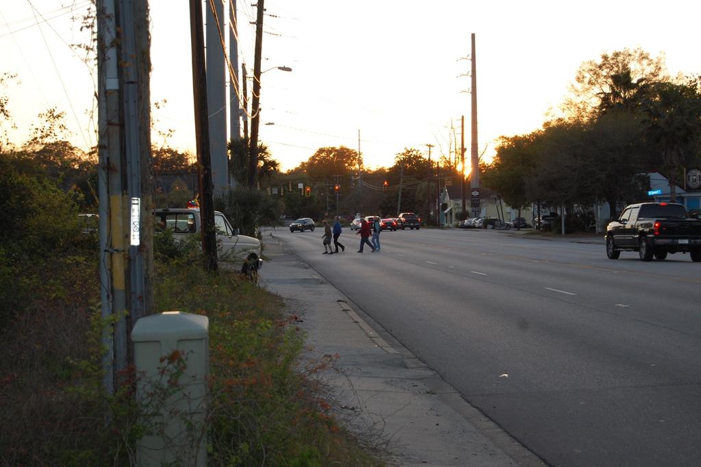
1 Charleston Moves staff and volunteers conducted a bicycle and pedestrian analysis at one key segment and two intersections along Maybank Highway on James Island: the intersections of Woodland Shores Drive and Wappoo Creek Drive, and the segment between the Terrace Shopping Center and the Pour House. We selected a Sunday during the community s Farmers Market (11am - 3), and a Wednesday evening (6:30-10:30 ). For each intersection or segment, we had at least one volunteer counting people on bike/foot in fifteen-minute intervals, tracked by mode and gender, and another tracked the movement of people on bike/foot in fifteen-minute intervals. Both of these volunteer roles utilized forms from the National Bicycle and Pedestrian Documentation Project. A third volunteer took notes, recording anecdotes from passers-by (including motorists) and incidents or patterns of significance. Because the segment between the Terrace Shopping Center and the Pour House is not a signalized intersection, we made a crosssection of the segment and had volunteers draw lines on it, tracking where people crossed on foot in fifteen-minute intervals. Our overall takeaways: 1.The sidewalk is way too narrow and too close to speeding cars. It is also not properly maintained anywhere except in front of The Standard (overgrown with vegetation and patches of sand). 2.Motorists drive recklessly.
2 3. Marked crosswalks at Woodland Shores do not match the habits of pedestrians or corresponding land uses. A vast majority of people prefer to cross over Woodland Shores Drive directly across from the temporary dirt parking lot, further from the intersection so they aren t up against speeding motorists and the dangerous curve. 4. Pedestrians (including young kids) walk in the road along Woodland Shores Drive headed to Pour House, as there is no sidewalk and parallel-parked cars cover the grassy area alongside the street.. Marked crosswalks are missing at Wappoo Creek Drive and therefore create a large barrier to what should be a walkable area. 6. There is no safe place for people on bicycles. 7. The vast majority of people crossing between the Terrace Shopping Center and Pour House are doing so within the segment from North Gevert Drive to the driveway next to Maybank Public House on the northern side of Maybank, and within the segment from the Pour House to Bryson s Garage on the southern side of Maybank. That would be an excellent place for a signalized mid-block crossing. (see Google image) 8. The diversity of people walking and biking is surprisingly varied, with a great number of infants, young children and dogs being exposed to a dangerous location. 9. Countless individuals and groups of people stopped to talk with us and ask what we were doing. All were in favor of slowing traffic and making the street safer for people walking and riding bikes. A number lamented about the number of people who have already been killed, and stated if conditions were safer, they d choose to bike or walk instead of driving to these locations. Segment of Maybank Highway from North Gevert Drive to approximately Stefan Drive Sunday, March 24, 2019 Weather: sunny, breezy, warm, clear Total: 661 people and dogs over 3. hours 11:1 7 am 11: 32 am 11: 47 am 12: 02 12: 17 12: 32 12: :1 p m 1:3 0 1:4 2 2:1 2:3 0p m 2:4 Total Fem ale Bicy clist Mal e Bicy clist
3 11:1 7 am 11: 32 am 11: 47 am 12: 02 12: 17 12: 32 12: :1 p m 1:3 0 1:4 2 2:1 2:3 0p m 2:4 Total Fem ale Ped estr ian Mal e Ped estr ian Dog s/ Bab ies TOT AL Movement tracked for 3/24: 17 people crossed from far west of Pour House 30 people went straight across from N. Gevert 1 people went straight across from the center of Public House 90 people went straight across from the driveway next to Public House 9 people crossed from between Pour House and Bryson s Garage to the driveway next to Public House 34 people crossed from the center of Bryson s Garage 1 people went straight across from the sidewalk in the center of the Terrace Theater 9 people crossed from the driveway of the shopping center near MediSpa people crossed from Stefan Drive Total: 274 people Notes: People crossing typically waited for traffic to break, but many were still forced to run across. Others waited in the center lane the ones who waited in the center lane tended to be older pedestrians. Sidewalks are filled with debris and sand. Motorists drive too close to the sidewalk. Most cyclists are coming from the western entrance of the Terrace parking lot through the Riverland Terrace neighborhood, and most are riding on the sidewalk. Many people spoke to our notetakers, commenting that they typically drive because they are scared to walk. One woman commented that her son lives across the street from the Public House,
4 where he works, but he still drives to work because it is difficult to cross the street on foot. Another couple stopped to tell us they live in the neighborhood on Stefan Drive and they are driving across the street to the Terrace Shopping Center for dinner because it s too dangerous to walk, though they d prefer to. Wednesday, March 27, 2019 Weather: chilly, clear, during sunset Total: 222 people and dogs over 4 hours 6:3 0 6:4 7 7:1 7:3 0 7:4 8 8:1 8:4 0 8: 9:1 0 9:2 9:4 0 9: 10:1 0 10: 30 Tot al Fe mal e Bic ycli st Mal e Bic ycli st Fe mal e Ped estr ian Mal e Ped estr ian Do gs/ Bab ies Tot al Movement tracked for 3/27: people crossed from far west of Pour House
5 48 people went straight across from N. Gevert 4 people went straight across from the center of Public House 41 people went from center of Pour House to center of Maybank Public House 13 people went straight across from the driveway next to Public House 6 people crossed from between Pour House and Bryson s Garage to the driveway next to Public House 1 person crossed from the center of Bryson s Garage 4 people crossed from the driveway of the shopping center near MediSpa 3 people crossed from Stefan Drive 10 people stayed on the south side of Maybank, heading west 26 people stayed on the south side of Maybank, heading east 2 people stayed on the north side of Maybank, heading west Total: 163 people Notes: Woman on foot was nearly hit by a car. Cyclists are on the sidewalk. Women with children are running across the street. Motorists drive for hundreds of feet in the center lane. Pedestrians often walk in grassy areas instead of on sidewalk. Multiple motorists cutting off other motorists, near-collisions. Not enough room on the sidewalk for two people. Group of three pedestrians frantically waving at car to stop while they are in the center of the road crossing. The street lamp at Stefan Drive is out. Once the sun set, pedestrians really ran quickly across the road. Several had flashlights with them. Intersection of Woodland Shores Drive and Maybank Highway Sunday, March Weather: sunny, breezy, warm, clear Total: 460 people and dogs over 1 hour and 4 minutes 11:17-11:32 am 11:32-11:47 am 11:47 am - 12:02 12:02-12:17 12:17-12:32 12:32-12:47 12:47-1 1:0-2:0 Total Female Bicyclist Male Bicyclist Female Pedestri an * * * 228
6 11:17-11:32 am 11:32-11:47 am 11:47 am - 12:02 12:02-12:17 12:17-12:32 12:32-12:47 12:47-1 1:0-2:0 Total Male Pedestri an Dogs/ Babies carried * * 36 Total 460 *1:0-2:0 No official count, but movement tracked. Movement tracked for 3/24: Most people on bike/foot traveled north along either side of Woodland Shores to the intersection of Maybank and made a right turn onto Maybank. A smaller but still significant number of people on bike/foot traveled west along Maybank and then turned south onto Woodland Shores. Virtually all of those people were actually crossing Woodland Shores before or after they reached the existing crosswalk, because it was more efficient to move to/from the temporary dirt parking lot on the southwest corner of the intersection. People going straight through the intersection from various directions were less in number. 110 went straight along Maybank, headed west. 2 people on bike/foot went straight along Maybank, headed east. 36 went straight along Woodland Shores, headed north. 31 people went straight along Woodland Shores, headed south. Notes: The high number of people parking in the temporary dirt lot need a safer way to cross Woodland Shores, and also need a sidewalk on Woodland Shores. Many motorists turning right onto Maybank (headed east) do not give pedestrians the right of way and pull out in front of them as they are crossing. Many pedestrians stopped to express their fear of the intersection to notetakers. Wednesday, March Weather: clear, chilly, during sunset Total: 37 people and dogs (and 1 golf cart) over 2 hours
7 6:30-6:4 6: :1 7:1-7:30 7:30-7:4 7: :1 8:1-8:30 8:4-10:30 Total Female Bicyclist Male Bicyclist Female Pedestri an Male Pedestri an * * * * 13 Other 1 golf cart dog * 2 Total 38 *8:4-10:30 No official count, but movement tracked. Movement tracked for 3/27: Even though fewer people used this intersection compared to Sunday, the movement was the same: virtually all of those people were crossing Woodland Shores on the southern end of the intersection before or after they actually got to the existing crosswalk. Notes: The pedestrian signal is not consistent at night, it does trigger, but in the daytime, pedestrians often must wait two cycles before they get a walk signal. Motor vehicles seem to trigger it. Cyclists coming from neighborhoods use the sidewalk. Neighbors refer to Riverland/Maybank intersection as dead man s curve. Setting sun seems to cause a problem with motorist visibility when headed west on Maybank. One motorist turning right onto Maybank, headed east, from Woodland Shores nearly hit one of our notetakers by jumping the curb. Many pedestrians stopped to express their fear of the intersection to notetakers. Motorists also expressed concerns to notetakers.
8 Closer to 9 is when the seriously dangerous behavior by motorists began to occur speeding, jumping lanes, running red lights. Pedestrians using crosswalks still had to run to avoid being hit. The area is dark and unlit, and pedestrians narrowly avoided collisions. Intersection of Wappoo Creek Drive and Maybank Highway Sunday, March 24, 2019 Weather: sunny, breezy, warm, clear Total: 34 people (and 1 moped) over 1 hour and 4 minutes 11:17-11:32 am 11:32-11:47 am 11:47 am - 12:02 12:02-12:17 12:17-12:32 12:32-12:47 12:47-1 Total Female Bicyclist Male Bicyclist Female Pedestria n Male Pedestria n Other moped on sidewalk 0 1 Total 3 Movement tracked for 3/24: There were very few people on bikes or foot at this intersection, but most movement was between The Standard and the shopping center. A few people tried to cross from the condos on the northern side of Maybank. Notes: A walk sign never appeared for pedestrians crossing Maybank Highway to Wappoo Creek Drive, and a beg button is missing. A crosswalk and signal is clearly needed to get to the shopping center on the western side of the intersection. Volunteers noted that most of their neighbors do not walk across the street because the intersection is dangerous and the sidewalks are too narrow.
9 Wednesday, March 27, 2019 Weather: clear, chilly Total: 13 people over 1 hour and 10 minutes 7:0-8:1 Female Bicyclist 1 Male Bicyclist 3 Female Pedestrian 4 Male Pedestrian Other 0 Total 13 Movement tracked for 3/27: The majority of people on bikes and foot were going to and from the direction of The Standard and into/out of the shopping center. One person walked from the condos at Wappoo Creek Drive, across Maybank to the shopping center, and then came back. PHOTOS BELOW


10 Charleston Moves 1630 Meeting Street, Suite 10 Charleston, SC 2940


11 Charleston Moves 1630 Meeting Street, Suite 10 Charleston, SC 2940


12 Charleston Moves 1630 Meeting Street, Suite 10 Charleston, SC 2940


13 Charleston Moves 1630 Meeting Street, Suite 10 Charleston, SC 2940


14 Charleston Moves 1630 Meeting Street, Suite 10 Charleston, SC 2940


15 Charleston Moves 1630 Meeting Street, Suite 10 Charleston, SC 2940


16 Charleston Moves 1630 Meeting Street, Suite 10 Charleston, SC 2940

17

18


19 Charleston Moves 1630 Meeting Street, Suite 10 Charleston, SC 2940

20


21
Arlington County Police Department Law Enforcement Guide. Enforcing Bicycle Traffic Laws
 Arlington County Police Department Law Enforcement Guide Enforcing Bicycle Traffic Laws Arlington County Police Department Safe Bicycling Initiative 2016 About the Arlington Safe Bicycling Initiative The
Strategies for Sharing the Road with Other Users
 Idaho Driver Education and Training Strategies for Sharing the Road with Other Users M15-1 Sharing the Road Introduction Idaho law requires motorists to operate their vehicles in a careful and prudent
Safety and Active Transport. Dr. Maureen Carew, Medical Officer of Health Renfrew County and District Health Unit May 30, 2014
 Safety and Active Transport Dr. Maureen Carew, Medical Officer of Health Renfrew County and District Health Unit May 30, 2014 Active Transport Vision Increase levels of walking and cycling Reduce vehicle
Cycle Track Design Best Practices Cycle Track Sections
 Design Best Practices Sections It is along street segments where the separation and protection methods of cycle tracks offer more comfort than conventional bicycle lanes, and are more attractive to a wide
Arlington County Police Department Law Enforcement Guide. Enforcing Bicycle Traffic Laws
 Arlington County Police Department Law Enforcement Guide Enforcing Bicycle Traffic Laws Arlington County Police Department Safe Bicycling Initiative 2017 About the Arlington Safe Bicycling Initiative The
Prevent Pedestrian Crashes:
 Prevent Pedestrian Crashes: Parents and Caregivers of Elementary School Children Elementary school children are very active and impulsive. Although they are learning and growing, school-age children 10
Pedestrian Safety Tips
 Pedestrian Safety Tips FACT: Pedestrian safety is the responsibility of BOTH the drivers on the road and the pedestrians. FACT: NO vehicle can Stop on a Dime. The average passenger vehicle traveling 40
Broad Street Bicycle Boulevard Design Guidelines
 Broad Street Bicycle Boulevard Design Guidelines Building from the strategies introduced in the 2013 Bicycle Transportation Plan and community input received thus far, City Transportation Staff have identified
PRINCE GEORGE S PLAZA METRO AREA PEDESTRIAN PLAN
 PRINCE GEORGE S PLAZA METRO AREA PEDESTRIAN PLAN May 28, 2008 Agenda Welcome and introductions Project overview and issue identification Planning context and strengths Design challenges and initial recommendations
COWETA HIGH SCHOOL AND EAST HIGHWAY 51
 COWETA HIGH SCHOOL AND EAST HIGHWAY 51 Lack of sidewalks along Ben Lumpkin Rd. Lack of crosswalks and ramps at intersection. Hwy 51 is wide to cross as a pedestrian. No ADA compliance or connection to
Traffic Calming & Cyclists
 Traffic Calming & Cyclists In the planning, design, and operation of transportation facilities bicyclists and pedestrians should be included as a matter of routine and the decision not to accommodate them
Bicycle Facilities Planning
 Bicycle Facilities Planning Overview Types of Cyclists Purpose for Riding Types of Facilities Bike Lanes Bicycle Boulevards Cycle Tracks Intersections Signals Signing and Marking Discussion Types of Bicyclists
Agenda. Overview PRINCE GEORGE S PLAZA METRO AREA PEDESTRIAN PLAN
 PRINCE GEORGE S PLAZA METRO AREA PEDESTRIAN PLAN May 28, 2008 Agenda Welcome and introductions Project overview and issue identification Planning context and strengths Design challenges and initial recommendations
EVERYONE IS A PEDESTRIAN CROSSING ADVICE FOR PEDESTRIANS
 B I C Y C L I N G I N C O L O R A D O EVERYONE IS A PEDESTRIAN CROSSING ADVICE FOR PEDESTRIANS Most of us cross streets every day. We take for granted that we can cross without incident because most of
A traffic safety guide concerning bicyclists, in-line skaters, pedestrians, non-motorized scooter operators, motorcyclists and motorists.
 New York State Governor s Traffic Safety Committee Eliot Spitzer, Governor David J. Swarts, DMV Commissioner & Chair nysdmv / safeny.com A traffic safety guide concerning bicyclists, in-line skaters, pedestrians,
Walk On, Victoria Pedestrian Issues Policy Research
 Issue: Distracted walking a. Study of police accident report data shows no correlation between distracted walking and an increase in injury or death, similar data for distracted driving shows a steep relationship.
Appendix C. TRAFFIC CALMING PROGRAM TOOLBOX
 Appendix C. TRAFFIC CALMING PROGRAM TOOLBOX PHASE I...2 Do Not Enter Sign...3 One-Way Sign...4 Turn Prohibition...5 Pavement Markings...6 Speed Monitoring Trailer...7 Neighborhood Speed Watch...8 Police
SAFE ROUTES TO SCHOOL
 SAFE ROUTES TO SCHOOL Forest Ridge Elementary School Existing Conditions and ACTION PLAN > Oak Creek - Franklin Joint School District Table of Contents CONTEXT Enrollment Boundaries
Bicycle Safety Skills
 Bicycle Safety Skills Presented by: MassBike Cape and Islands Chapter MassBike John Fallender December 20, 2010 Cape & Islands Chapter 1 Welcome to Cape Cod 2 Bikes are vehicles? What does that mean? That
LTAC: Katie Mencarini, Central & Hampton Roads streets and a fifteen minute debrief to discuss the findings. Participants walked along Mill Road
 Walkabout Summary On June 3, 2013, five participants met at Glen Allen Elementary School in Glen Allen, Virginia to take a closer look at the walking and biking network around the school. In addition to
Final Report 2012 Chicago Department of Transportation 30 N. LaSalle St., Ste 500 Chicago IL Gabe Klein, Commissioner
 Final Report 2012 Chicago Department of Transportation 30 N. LaSalle St., Ste 500 Chicago IL 60602 Gabe Klein, Commissioner 1 Funders Partner Organizations Monetary Contributions In-Kind Donations 2 Executive
Complete Streets: Building Momentum in Connecticut
 Complete Streets: Building Momentum in Connecticut Tri-State Transportation Campaign, 2012 What are Complete Streets? Complete Streets are safe, comfortable, and convenient for travel for everyone, regardless
Ohio Share the Road Driver s s Education Unit
 Ohio Share the Road Driver s s Education Unit Bicyclists are Drivers of Vehicles 4501.01. Definitions (A) "Vehicle" means every device, including a motorized bicycle, in, upon, or by which any person or
Dec 2, Dear Tri Ong, Sam Woods, and Scott Kubly,
 Dec 2, 2014 Dear Tri Ong, Sam Woods, and Scott Kubly, Thank you for providing us with the 2015 Arterial Asphalt and Concrete (AAC) repaving project 60% plan for Roosevelt Way NE. It's exciting to see the
25th Avenue Road Diet Project A One Year Evaluation. Transportation Fund for Clean Air Project #05R07
 25th Avenue Road Diet Project A One Year Evaluation Transportation Fund for Clean Air Project #05R07 Submitted by: The San Francisco Municipal Transportation Agency Dan Provence May 22, 2009 EXECUTIVE
Appendix A. Knoxville TPO Greenway Signage Guidelines. Appendix A: Knoxville TPO Greenway Signage Guidelines Knox to Oak Ridge Greenway Master Plan
 Appendix A Knoxville TPO Greenway Signage Guidelines 75 Overview: Adequate signing and marking are essential on shared-use paths, especially to alert bicyclists to potential conflicts and to convey regulatory
MEET IN THE STREET MOVING TO ZERO
 WE MEET IN THE STREET MOVING TO ZERO Tips for sharing the street Traffic deaths are preventable. We need your help getting the message out. 2 A NEW PLAN A NEW PLAN Philadelphia is proud to adopt Vision
BICYCLE RULES OF THE ROAD
 ILLINOIS ILLINOIS ILLINOIS ILLINOIS ILLINOIS ILLINOIS ILLINOIS ILLINOIS BICYCLE RULES OF THE ROAD Jesse White Secretary of State Bicycle riding is a great way to get into shape and enjoy the outdoors.
Designing for Pedestrian Safety
 Designing for Pedestrian Safety Introduction to Pedestrian Safety Design and Planning Principles Presented by: Craig Allred FHWA Resource Center Technical Specialist and Michael Ronkin Owner, Designing
SAFE ROUTES TO SCHOOL
 SAFE ROUTES TO SCHOOL Edgewood Elementary School Existing Conditions and ACTION PLAN > Oak Creek - Franklin Joint School District Table of Contents CONTEXT Enrollment Boundaries Enrollment
Parental Responsibilities
 Bicycle riding is a fun way to exercise and enjoy the outdoors. To remain safe on Illinois roads, bicyclists must obey the same traffic safety laws that govern vehicle drivers. No amount of bicycle safety
What future for mid-sized cities? Prof. Emer. Antony Stathopoulos National Technical University of Athens
 What future for mid-sized cities? Prof. Emer. Antony Stathopoulos National Technical University of Athens These cities can range in size from 50,000 to 250,000 in population. Street in Larnaca in 1878
Steps to Conducting a Complete Streets Assessment
 Steps to Conducting a Complete Streets Assessment Familiarize yourself with Complete Streets Read through the Complete Streets Assessment Guidelines. This will give you an idea of what Complete Streets
Borough of Danville, PA Traffic Calming Program Guidelines
 Borough of Danville, PA Traffic Calming Program Guidelines Adopted by Borough Council on 1 INTRODUCTION Speeding Traffic is a major concern in the Borough of Danville because of its detrimental impacts
Why Zone In on Speed Reduction?
 Learn it. Do it. Live it! SPEED REDUCTION IN THE ZONE Why Zone In on Speed Reduction? Speeding is a serious issue that plays a major role in the risk of serious injury and pedestrian fatality in a crash.
REGIONAL BICYCLE AND PEDESTRIAN DESIGN GUIDELINES
 REGIONAL BICYCLE AND PEDESTRIAN DESIGN GUIDELINES November 16, 2011 Deb Humphreys North Central Texas Council of Governments Bicycle and Pedestrian Advisory Committee Snapshot of the Guide 1. Introduction
TO: VDoT, FDoT. CC: Cathy Hudgins, Paul Davis FROM: RA. RE: Critical intersections surrounding the Wiehle-Reston East Metro station
 TO: VDoT, FDoT CC: Cathy Hudgins, Paul Davis FROM: RA RE: Critical intersections surrounding the Wiehle-Reston East Metro station As the Wiehle-Reston East Metro Station nears operation, Reston Association
Southside Pilot Proposal
 To improve bicycle access and mobility to UC Berkeley, Downtown Berkeley, and the Southside area, a pilot project could include a two-way parking-protected cycle track. Turn pockets and island bus stops
o n - m o t o r i z e d transportation is an overlooked element that can greatly enhance the overall quality of life for the community s residents.
 N o n - m o t o r i z e d transportation is an overlooked element that can greatly enhance the overall quality of life for the community s residents. 84 Transportation CHAPTER 11 INTRODUCTION Transportation
How to Develop a Pedestrian Safety Action Plan
 How to Develop a Pedestrian Safety Action Plan Course Introduction Presented by: Peter Eun FHWA RC Safety Engineer Ryan Snyder President, Ryan Snyder Associates, LLC Paul Zykofsky Director, Land Use and
What Is a Complete Street?
 Session 5 Charleen Zimmer, AICP, Zan Associates May 5-7, 2010 What Is a Complete Street? May 2010 5-1 Not a Complete Street More of a Complete Street May 2010 5-2 Benefits of Complete Streets Safety for
City Snapshot September 27, 2018
 1 City Snapshot September 27, 2018 Respondent Introduction Thank you for providing data for the PlacesForBikes City Rating program! The information you provide will be used to understand the progress your
Sherwood Drive Traffic Circle
 Strathcona County Sherwood Drive Traffic Circle Online Survey Results April 7, 215 I. Executive Summary The Sherwood Drive Traffic Circle Survey was administered in March 215. In total, 2,263 residents
Seaside Greenway South - Assessment Ride 2
 Seaside Greenway South - Assessment Ride 2 HUB Cycling Vancouver UBC Local Committee - Seaside South Working Group Vancouver@bikehub.ca August 2, 2016 Executive Summary The HUB Vancouver UBC Local Committee
G AT E WAY PLAN. Community BRIEFING KIT GATEWAY BIKE
 G AT E WAY PLAN GATEWAY BIKE Community BRIEFING KIT PLAN August 2016 TABLE OF CONTENTS INTRODUCTION... 1 THE BENEFITS OF A BIKEABLE COMMUNITY... 2 ECONOMY...2 SAFETY...3 HEALTH...3 HOUSEHOLD SPENDING...3
H Jumpers Hole Road from MD 2 to MD 177. Compiled Online Posting Public Comments 11/9/17
 H539609 Jumpers Hole Road from MD 2 to MD 177 Compiled Online Posting Public Comments 11/9/17 1. Need a traffic light and safe bicycle and pedestrian passage. Countless situations where cars put peds in
Active Transportation Facility Glossary
 Active Transportation Facility Glossary This document defines different active transportation facilities and suggests appropriate corridor types. Click on a facility type to jump to its definition. Bike
FLETCHER AVENUE PEDESTRIAN AND BICYCLIST BEHAVIOR CHANGE FORMATIVE RESEARCH PROJECT
 FLETCHER AVENUE PEDESTRIAN AND BICYCLIST BEHAVIOR CHANGE FORMATIVE RESEARCH PROJECT EXTENT OF CHANGES IN PEDESTRIAN AND BICYCLIST ATTITUDES AND BEHAVIORS DIRECTLY AFTER A COMPLETE STREETS PROJECT IN FLORIDA
157 Chapter 6: Bicycles
 Chapter 6: Bicycles 157 158 Bicycle use continues to increase as more people use a bicycle for transportation, recreation, physical fitness and energy conservation. Cyclists must obey the rules of the
APPENDIX 1 CITY OF CALGARY SHARE THE PATHWAY PROGRAM
 APPENDICES APPENDIX 1 CITY OF CALGARY SHARE THE PATHWAY PROGRAM Share the Pathway Share the pathway and share the responsibilities. Those who use the pathway get along better when they show courtesy and
BICYCLE SAFETY: A PARENT S GUIDE
 BICYCLE SAFETY: A PARENT S GUIDE Thank you for partnering with the Newport Beach Police Department to help make your child a safer bicyclist. BE A ROLL MODEL LEARN. As a parent, it is important that you
GARLAND ROAD/GASTON AVENUE/ GRAND AVENUE INTERSECTION IMPROVEMENT STUDY
 MEETING OF AFFECTED PROPERTY OWNERS AND STAKEHOLDERS GARLAND ROAD/GASTON AVENUE/ GRAND AVENUE INTERSECTION IMPROVEMENT STUDY CSJ 0009-02-067 Meeting Agenda 1 2 3 4 5 6 7 8 9 10 Opening Remarks State Representative
Bicycle - Motor Vehicle Collisions on Controlled Access Highways in Arizona
 Bicycle - Motor Vehicle Collisions on Controlled Access Highways in Arizona Analysis from January 1, 1991 to June 30, 2002 Richard C. Moeur, PE Traffic Design Manager, Northern Region Michelle N. Bina
STEERING COMMITTEE MEETING June 17, Streetscape Overview Burlington Comprehensive Master Plan
 STEERING COMMITTEE MEETING June 17, 2015 Streetscape Overview Burlington Comprehensive Master Plan 1 Introduction Slide This slide show was presented to the Burlington Steering Committee on June 17, 2015
Clybourn Ave. Protected Bike Lane Study Halsted St. to Division St.
 Clybourn Ave. Protected Bike Lane Study Halsted St. to Division St. Nathan Roseberry, Senior Engineer Pam Broviak, Project Manager July 24, 2014 Agenda Project Goals Existing Roadway Conditions Traffic
Pedestrian Safety at Roundabouts. Presentation to the Howard-Suamico School Board November 26, 2007
 Pedestrian Safety at Roundabouts Presentation to the Howard-Suamico School Board November 26, 2007 Roundabouts that have replaced stop signs and traffic signals have reduced the number and severity of
Community & Transportation Preferences Survey
 Community & Transportation Preferences Survey Webinar: August 5, 2015 Hugh Morris, AICP, LEED Realtor.org Jennifer Dill, Ph.D. trec.pdx.edu 1 Introduction National Association of Realtors Over 1,000,000
Pedestrian Safety Lesson Plan
 Subject Navigating Traffic Environments Safely Pedestrian Safety Lesson Plan Age level Recommended for children ages 10-14 years old Background Children see, hear, and process information differently than
Pedestrian Survey Report
 Pedestrian Survey Report The City of Albany conducted a Pedestrian Survey in 2007 with the purpose of identifying resident s concerns about barriers to walking and accessibility in the City. The survey
Unit Six: Driving Faster with More Risk URBAN, SUBURBAN, AND RURAL DRIVING
 Unit Six: Driving Faster with More Risk URBAN, SUBURBAN, AND RURAL DRIVING What Is The Impact Of Distraction? Objectives For Unit Six Students will be able to describe the skills necessary to What safely
Peninsula Velo Cycling Club. Riding Etiquette and Expectations on the Road
 Peninsula Velo Cycling Club Riding Etiquette and Expectations on the Road Objectives: 1. Improve safety for cyclists on the road. 2. Improve our relations with car drivers, motorcyclists, pedestrians,
Controlled. Semi-Controlled PAGE 01 CHAPTER 12 INTERSECTIONS
 PAGE 01 CHAPTER 12 INTERSECTIONS You will cross many intersections while driving. Intersections are especially dangerous because vehicles are crossing each other s driving path. Many crashes happen at
Monument Elementary School Trenton, NJ School Travel Plan
 Monument Elementary School Trenton, NJ School Travel Plan Prepared by Greater Mercer TMA With Assistance from Alan M. Voorhees Transportation Center; Rutgers, The State University of New Jersey and NJ
Illustrated Principles of Good Planning
 Illustrated Principles of Good Planning The Miami 21 Zoning Code incorporates time-tested planning principles into the zoning regulations of our City. These are principles that make for better neighborhoods,
INTERSECTION DESIGN TREATMENTS
 Designing for Bicyclist Safety INTERSECTION DESIGN TREATMENTS LEARNING OUTCOMES Understand intersection design options and features Select appropriate design feature for a bikeway in a given context C1
Construction Newsletter No. 32 October 14, 2016 On-Going
 Construction Newsletter No. 32 October 14, 2016 On-Going Here s a block-by-block breakdown of the work currently underway: Harvey Street to Clegg Street: Placement of green thermoplastic for the cycle
in the pop-up survey after drawing it. UPLOAD PHOTOS when you add a route or point or by clicking on an existing route or point.
 Introduction As part of the first phase for the West Elizabeth Enhanced Travel Corridor Plan an online interactive map WikiMap was created and available for input. A link to the WikiMap was distributed
Comments EXECUTIVE SUMMARY
 Comments 1. Under any Alternatives, MCDOT should provide better at-grade pedestrian crossing of Georgia Avenue and Forest Glen Road, including improved crosswalks with wider medians and adequate signal
Instructions for Counting Pedestrians at Intersections. September 2014
 Instructions for Counting Pedestrians at Intersections September 2014 Purpose This document introduces the concept of the pedestrian count and provides instructions for performing a manual intersection
Arlington Public Schools Thomas Jefferson Site Evaluation Transportation Networks. Thomas Jefferson Working Group Meeting #6 November 10, 2014
 Arlington Public Schools Thomas Jefferson Site Evaluation Transportation Networks Thomas Jefferson Working Group Meeting #6 November 10, 2014 2 3 INTRODUCTION 4 Goal of our work: Identify and assess multi-modal
See Figure 38, Existing Nonmotorized Connections.
 Nonmotorized Connections Existing Nonmotorized Connections Pedestrian, vehicle and bike traffic access and movements are confined primarily to Penny Drive on campus. Due to the steep slope along the length
One of the following facts is false. Can you guess which one? Circle it!* *Answer is at the bottom of the page. 260,000 children
 More and more ROADS are being built, that take us far and wide. But every two minutes a child or teenager dies in a CRASH on these roads, and another thirty-eight are injured. One of the following facts
Orange Center Elementary School
 Drag and drop pic and stretch/crop to the limits of the blue rectangle (delete this text box) Orange Center Elementary School Drag and drop pic and stretch/crop to the limits of the blue rectangle (delete
Summary of Comments Public Meeting: Marietta Street Resurfacing Project Atlanta Contemporary August 29, 2017 / 6:00 pm to 8:00 pm
 Renew Atlanta hosted a public meeting to discuss the Marietta Street Resurfacing project at. Councilmember Cleta Winslow attended the public meeting, where over seventy (70) citizens to include representatives
The Wiggle Route in Context
 The Wiggle Route in Context In a city of hills, the Wiggle is an important route because it winds its way along the flattest streets from Market to the Panhandle, bringing residents to local parks and
1 st and 2 nd Street Couplet FAQ s
 1 st and 2 nd Street Couplet FAQ s Q. Will the proposed roundabout at Flume/2nd/1 st Streets affect access to businesses nearby?... 2 Q. What if the project isn t received well by the community after construction?...
Driverless Vehicles Potential Influence on Bicyclist Facility Preferences
 Driverless Vehicles Potential Influence on Bicyclist Facility Preferences MICHAEL BLAU, MCRP, LCI O T E C O C T O B E R 2 6, 2 0 1 6 S E S S I O N # 8 2 - E V A L U AT I N G T H E P E R F O R M A N C E
J Street and Folsom Boulevard Lane Conversion Project (T ) Before and After Traffic Evaluation
 Before and After Traffic Evaluation") J Street and Folsom Boulevard Lane Conversion Project (T15125400) Before and After Traffic Evaluation Prepared by Transportation Division June 2014 Executive Summary On February 12, 2013, the City of Sacramento
J Street and Folsom Boulevard Lane Conversion Project (T15125400) Before and After Traffic Evaluation Prepared by Transportation Division June 2014 Executive Summary On February 12, 2013, the City of Sacramento
Dear Mr. Tweed: Sincerely, Min Zhou, P.E. Vice President
 December 17, 2012 Mr. Steve Tweed City of Long Beach, Department of Public Works Traffic & Transportation Bureau, 10 th Floor City Hall 333 West Ocean Boulevard Long Beach, CA 90802 Subject: Broadway and
2014 Wisconsin Tribal Transportation Conference. Matt Halada Transportation Planner NE Region
 2014 Wisconsin Tribal Transportation Conference Matt Halada Transportation Planner NE Region Implementing Wisconsin s Pedestrian and Bicycle Accommodations Law (Complete Streets) Tools and methods for
DELDOT s Concrete Islands
 DELDOT s Concrete Islands New concrete islands, contrary to Delaware s Bicycle Policy, are being designed as obstacles to a cyclist s right of way through intersections. They add a further danger where
RE: Natomas Landing (P99-091)
") August 2, 2008 David Hung, Associate Planner Current Planning Division Development Services Department 300 Richards Boulevard, 3rd Floor Sacramento, CA 95811 RE: Natomas Landing (P99-091) Dear Mr. Hung:
August 2, 2008 David Hung, Associate Planner Current Planning Division Development Services Department 300 Richards Boulevard, 3rd Floor Sacramento, CA 95811 RE: Natomas Landing (P99-091) Dear Mr. Hung:
Factoria Area Transportation Study Update Walking Audits
 Factoria Area Transportation Study Update Walking Audits As part of the city of Bellevue s update to the Factoria Area Transportation Study (FATS), Feet First conducted walking audits of the Factoria area
Film Guide for Educators. Designing for Safety
 Film Guide for Educators Designing for Safety Designing For Safety Key Concepts Speeding While Driving Speeding is the number one cause of injuries and deaths from driving. The main reasons are because
PETITION AND LETTER WRITING BEST PRACTICES
 PETITION AND LETTER WRITING BEST PRACTICES Petitions and campaign letters can be a great way to bring important bicycle and pedestrian policies and projects to the attention of elected officials. They
City of Vallejo Traffic Calming Toolbox
 City of Vallejo Traffic Calming Toolbox June 1, 2013 Final Table of Contents Introduction... 1 Non-Physical Devices... 3 High-Visibility Crosswalk... 3 In Pavement Lighted Crosswalk... 4 Rapid Flashing
Appendix T CCMP TRAIL TRAFFIC & TRANSPORTATION DESIGN STANDARD
 Appendix T CCMP 3.3.4 TRAIL TRAFFIC & TRANSPORTATION DESIGN STANDARD 3.3.4 Trail Traffic and Transportation Design Multi-use trails have certain design standards, which vary depending on the agency that
Highway School, Ithaca NY
 Highway School, Ithaca NY June 1, 2009 Michael Ronkin Designing Streets for Pedestrians and Bicyclists 1 We know how to build right 6 Yet many roads are built like this 7 What is a Complete Street?
The DC Pedestrian Master Plan
 The DC Pedestrian Master Plan September 28, 2010 George Branyan Pedestrian Program Coordinator District Department of Transportation Presentation Agenda Scope of the Plan Methodology Recommendations Implementation
Route 29 Solutions Projects
 Route 29 Solutions Route 29 Solutions Projects www.route29solutions.org October 10, 2014 Route 29 Widening to Six Lanes Albemarle County This project will widen a 1.8-mile segment of Route 29 from four
Use this guide to learn more about walkability and how you can make your community safer to walk
 Walkability Guide Do You Enjoy Walking In Your Community? Use this guide to learn more about walkability and how you can make your community safer to walk 2 About This Guide Circulate San Diego believes
Goodlettsville Bicycle and Pedestrian Plan Executive Summary
 Goodlettsville Bicycle and Pedestrian Plan July 2010 In Cooperation with the Nashville Area Metropolitan Planning Executive Organization Summary Introduction Progressive and forward thinking communities
General Design Factors
 Chapter 3: 3-1.0 Introduction General Design Factors Mn/DOT s goals include encouraging and accommodating safe bicycling. From a design perspective, these goals are achieved by first having an understanding
Multi-Modal Traffic Analysis. Parisi and Associates
 Mill Valley to Corte Madera Bicycle and Pedestrian Corridor Study Appendix D: Multi-Modal Traffic Analysis Prepared by Parisi and Associates August 2009 Appendix D - Multi-Modal Traffic Analysis Table
DEPARTMENT OF ENVIRONMENTAL SERVICES. North Harrison Street (Lee Highway to Little Falls Road) Comparative Analysis. Prepared for:
 Comparative Analysis. Prepared for:") DEPARTMENT OF ENVIRONMENTAL SERVICES North Harrison Street (Lee Highway to Little Falls Road) Comparative Analysis Prepared for: Arlington County Department of Environmental Services 2100 Clarendon Boulevard,
DEPARTMENT OF ENVIRONMENTAL SERVICES North Harrison Street (Lee Highway to Little Falls Road) Comparative Analysis Prepared for: Arlington County Department of Environmental Services 2100 Clarendon Boulevard,
INTERSECTION DESIGN. Bicycle Facility Workshop Intersections 4-1
 INTERSECTION DESIGN 4-1 Intersections Avoid unusual conflicts Provide direct path for cyclists, close to that of motor vehicles Bicyclists should be visible; their movements should be predictable Simple
Chapter 4 TOOLBOX AND SAMPLE BIKE BOULEVARD LAYOUT
 Chapter 4 TOOLBOX AND SAMPLE BIKE BOULEVARD LAYOUT OVERVIEW This chapter describes a cohesive set of strategies to create a bicycle boulevard, namely to make streets safer and more efficient for bicycle
Topsham, ME. September 20, A Joint Project of the Maine Department of Transportation and the Bicycle Coalition of Maine
 Topsham, ME September 20, 2017 A Joint Project of the Maine Department of Transportation and the Bicycle Coalition of Maine Agenda Welcome: Intros, Agenda, Using Clicker Tech Perceptions and Realities
City of Davis East Covell Corridor Plan
 Community Open House #2 January 22, 2014 6:00 8:00 p.m. Veterans Memorial Center, Club Room City of Davis Introduction The (ECCP) is a taking a comprehensive look at the existing transportation systems
INTERSECTIONS AT GRADE INTERSECTIONS
 INTERSECTIONS 1 AT GRADE INTERSECTIONS INTERSECTIONS INTERSECTIONS = INTERRUPTED FACILITIES Definitions and key elements An intersection is defined as an area where two or more roadways join or cross.