MEMORANDUM. Mayor and Boise City Council. Hal Simmons - Planning Director Boise City Planning and Development Services
|
|
|
- Myra Manning
- 5 years ago
- Views:
Transcription

1 MEMORANDUM TO: FROM: PREPARED BY: Mayor and Boise City Council Hal Simmons - Planning Director Boise City Planning and Development Services Leon Letson Associate Planner Boise City Planning and Development Services MEETING DATE: September 13, 2016 RE: Highlands Cove Traffic Distribution CFH / PUD / SUB Highlands Cove, LLC is requesting approval of a Traffic Study and Mitigation Plan associated with a 57-unit planned residential development located at 1200 E. Highland View Drive. The following record is provided for your review: Page 2 Summary of City Council Action Page 2 Summary of Traffic Study and Mitigation Plan Page 3 Planning Team Recommendation Page 5 Traffic Study and Mitigation Plan Materials Page 20 Highlands Area Recommended Traffic & Safety Improvements Report ACHD Memo dated July 22, 2016 Page 22 Highlands Cove Subdivision Review ACHD Memo dated August 6, 2015 Page 56 Highlands Neighborhood Association Comments
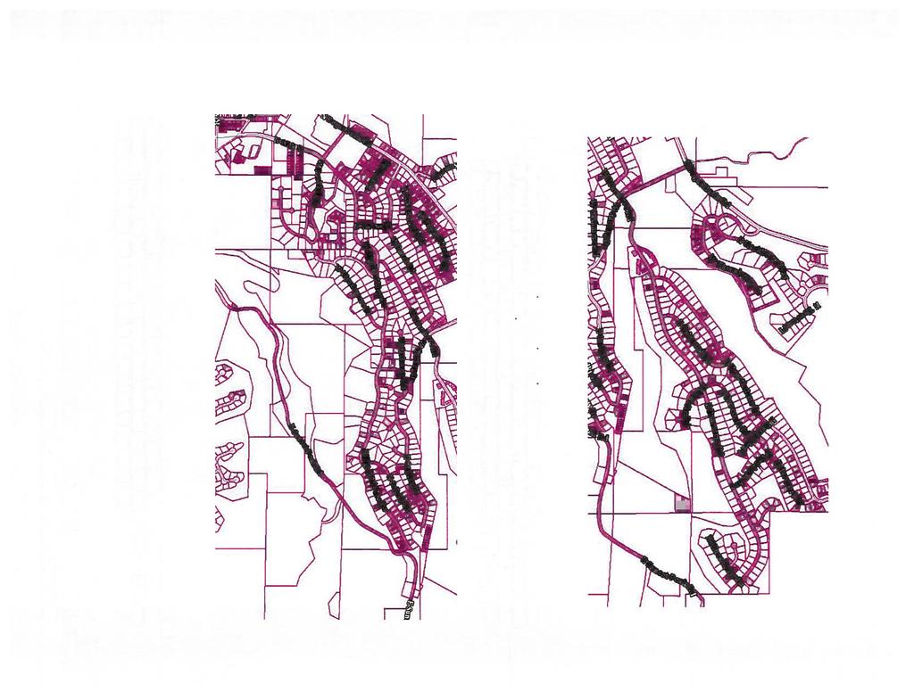
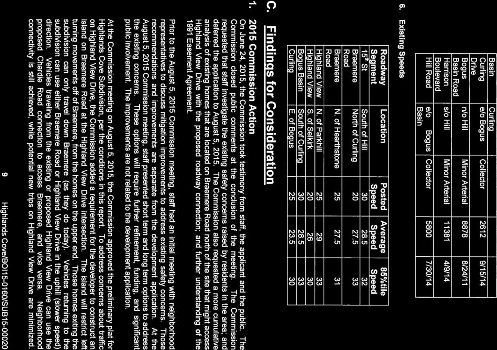
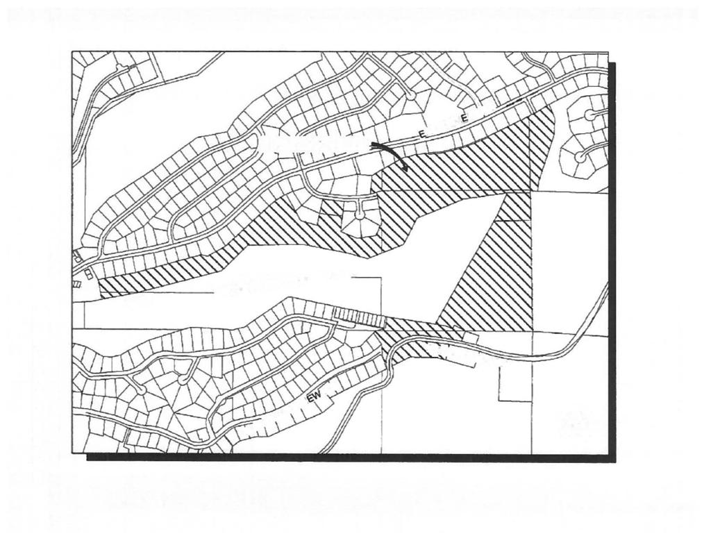
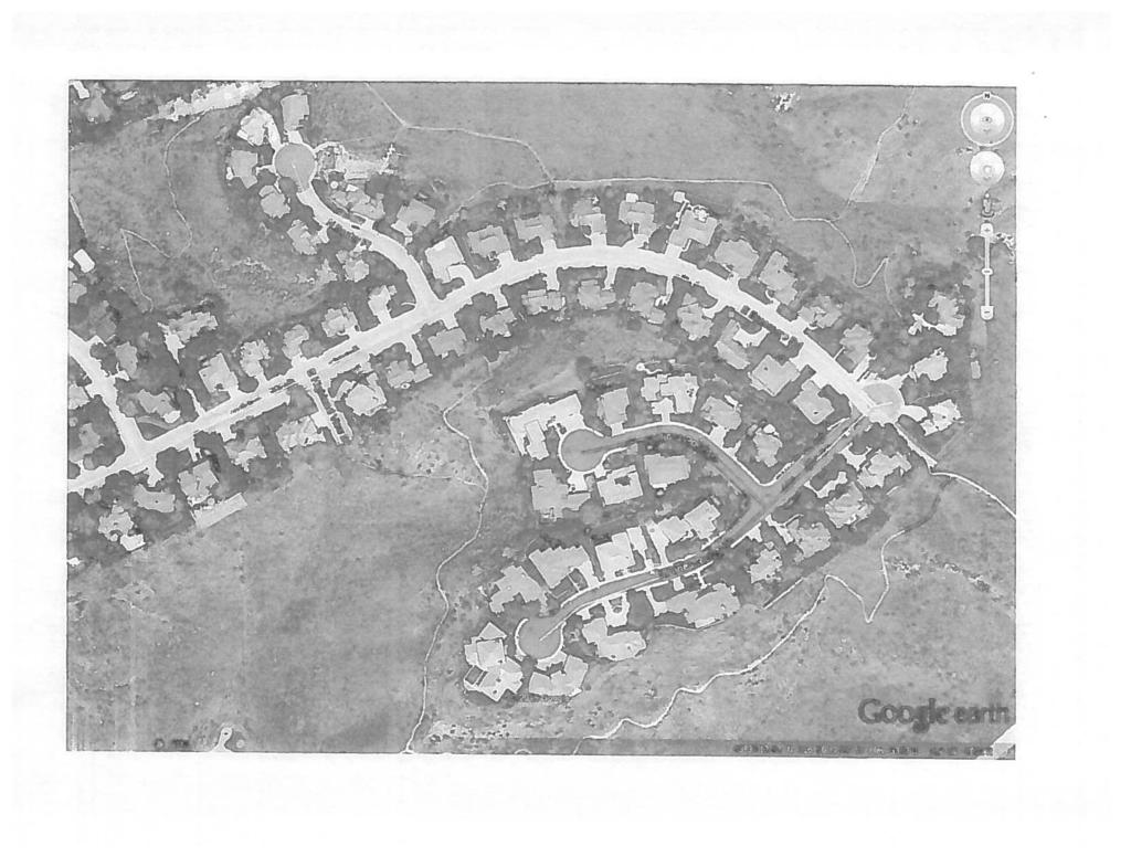
2 CFH , PUD & SUB City Council September 13, 2016 Page 2 Summary of City Council Action On December 15 th, 2015, City Council approved a 57-unit planned residential development at 1200 E. Highland View Drive referred to as Highlands Cove. Per this approval, the developer was required to submit a Traffic Study and Mitigation Plan in accordance with the following condition of approval: 3.a Prior to approval of the Final Plat, the applicant shall submit a Traffic Study and Mitigation Plan to the City for review and approval. The Mitigation Plan shall outline a minimum of $120,000 in improvements within the surrounding neighborhood that shall be designed, as modeled by the Traffic Study, to direct no more than 50% of the anticipated traffic from this development to Highland View Drive. Summary of Traffic Study and Mitigation Plan The Highlands Cove Traffic Study and Mitigation Plan submitted by the applicant asserts that 60%- 70% of the traffic generated from Highlands Cove will make use of E. Braemere Road as the primary route in and out of the development, even without additional traffic calming or traffic diversion measures. This conclusion is based on assumed destinations and that drivers choose to take the route with the shortest travel time. Travel times are calculated using distance of travel and speed of travel, which is based on posted speed limits. The fact that average speeds are slightly higher than posted speed limits on E. Braemere Road and Highland View Drive is acknowledged. However, because the difference between the posted speed and observed vehicle speed is essentially equal between roadways, it is assumed that travel times are affected proportionally. Destination intersections included in the study are Bogus Basin Road-Hill Road and 15 th Street-Hill Road. Although the majority of traffic will travel to Downtown Boise from these intersections, the developer anticipates that at least 25% will travel west along Hill Road, based on 2012 traffic counts. The current layout of the development has 24 of the 57 homes (42%) located along Chardie Road and Highland View Drive, north of the Chardie Road-Highland View Drive intersection. It is expected that these homes will make use of E. Braemere Road as their primary route in and out of the development due to a shorter distance than travelling on Highland View Drive (1.36 miles on Braemer vs miles on Highland View Drive) and travel time to the destination intersections (5.60 minutes on Braemer vs minutes on Highland View Drive). Of the remaining 33 homes, approximately 8, or 25%, are expected to also make use of the E. Braemere Road route to reach destinations to the west of the Bogus Basin-Hill Road intersection, based on the previously noted traffic split for the Bogus Basin Road-Hill Road intersection. These homes, in addition to the 24 along Chardie Road and Highland View Drive, north of the Chardie Road-Highland View Drive intersection represent 56% of the total development. Regarding the remaining 25 homes, an unspecified majority are expected to also make use of E. Braemere Road, which supports the 60%- 70% traffic distribution noted earlier. To ensure that no more than 50% of traffic from the development makes use of Highland View Drive, the use of chicanes or center islands within the new extension of Highland View Drive are recommended by the developer, as are speed bumps along existing Highland View Drive. The Traffic Study and Mitigation Plan was transmitted to the Highlands Neighborhood Association (HNA) and comments were received. After noting concerns about various aspects of the Traffic Study, the following conditions were requested:
3 CFH , PUD & SUB City Council September 13, 2016 Page 3 1. Require the installation of the one-way traffic diverter at the Highland View Drive-E. Braemere Road intersection in the initial phase of the development. 2. Require the construction of the Chardie Road extension in the initial phase of the development. 3. Require a chicane near the new extension of Highland View Drive in the southern portion of the development. 4. Provide an assured commitment to continued monitoring and mitigation during the build-out of the development. 5. Install future active mitigation projects, as needed. Planning Team Recommendation In addition to the materials submitted by the applicant, the Planning Team based the following recommendation on the recent effort undertaken by ACHD to address pedestrian, bicycle, and vehicle safety in the greater Highlands Neighborhood. In an attached memo from ACHD dated July 22, 2016, several mitigation projects are outlined by roadway, the bulk of which consist of upgrading key intersections with stop signs and crosswalks. Also included are improvements to lighting, signage, and pedestrian facilities (i.e. filling sidewalk gaps; creating on-street walkways with striping, extruded curb, or candles, etc.), as well as a one-way traffic diverter at the Curling Drive-E. Braemere Road intersection to allow right turns only from eastbound Curling Drive to southbound W. Braemere Road. Another one-way traffic diverter will also be installed at the Highland View Drive-E. Braemere Road intersection to prevent traffic to the north of this intersection from making use of Highland View Drive as a route in and out of the neighborhood. This was required with ACHD s original approval of the Highlands Cove development and is not included in the most recent list of mitigation projects. Several of these improvements have been completed, including the installation of stop signs and the one-way traffic diverter at the Curling Drive-E. Braemere Road intersection. Regarding the impact of these ACHD projects on the developer s Traffic Study and Mitigation Plan, they further support the assertion that Braemere Road will be the preferred route in and out of the development. In particular, additional stop signs, crosswalks, and a walking path on Highland View Drive will serve as traffic calming measures to slow vehicles travelling on this route. The chicanes or center islands proposed as part of the new Highland View Drive extension should also assist in discouraging the use of Highland View Drive by vehicles. However, the speed bumps proposed by the developer have been identified by ACHD and the neighborhood as something not to be pursued. The Planning Team recommends approval of the Traffic Study and Mitigation Plan with the following conditions: 1. Of the $120,000 to be provided by the developer for traffic calming, the City shall receive and administer $100,000; the remaining $20,000 shall be received and administered by ACHD, per their approval memo dated August 6, The $120,000 in funding from the developer may be used toward chicanes or center islands within the development; remaining funds shall be used on traffic calming projects outside of those identified in the July 22, 2016 ACHD memo Highlands Area Recommended Traffic & Safety Improvements Report. 3. The proposed traffic diverter at the Highland View Drive-E. Braemere Road must provide bicycle and pedestrian access through the diverter via gaps in the raised concrete or the use of candlesticks, versus raised concrete, for the diverter; this project is to be funded outside of
4 CFH , PUD & SUB City Council September 13, 2016 Page 4 the $120,000 dedicated to traffic calming. 4. The proposed traffic diverter at the Curling Drive-E. Braemere Road intersection should be installed and tested as a two-phase pilot project to establish the optimal traffic volume diversion. The amount of traffic diverted from W. Braemere needs to be balanced with the overall mobility and connectivity of the Highlands neighborhood.
5 July 26, 2016 Leon Letson Boise City Planning & Development Services PO Box 500 Boise, ID RE: Highlands Cove Subdivision/PUD , CFH , & SUB /1200 E. Highland View Dr Dear Mr. Letson: In compliance with site specific condition 3a for the Highlands Cove Subdivision, please see the attached traffic distribution report prepared by Dan Thompson for the City s review and approval. Also attached is a supplemental memo to ACHD regarding the Braemere island. The report works with the Traffic Study for the area and then further analyzes the expected traffic distribution from this development utilizing the preliminary plat as approved without the 3 lots on Highland View Drive. As you will see, the report concludes that less than 50% of the anticipated traffic from this development will use Highland View Drive. As a result, no off-site mitigation measures were recommended to satisfy the condition since the condition will be met. At the conclusion of the report, alternative ways to further discourage traffic on Highland View Drive are considered. If any are implemented, they will help ensure no more than 50% of the traffic from this development will use Highland View Drive. Based upon the site topography and input from the traffic engineer, Dan Thompson, and our civil engineer, Dave Sterling, the traffic measure that we will recommend installing within our development are traffic separating islands in Highland View Drive. The islands will be in the southern section of the development in the area where there will not be homes so that off-street parking is not negatively impacted for the future homes. Installing these islands will encourage slower traffic in this area, which in turn should help ensure less than 50 percent of the traffic from our development will use Highland View Drive. Even though this report concludes that no additional traffic measures are needed to comply with the condition, we agree to pay the balance of the $120,000 required in this condition, after the cost of these islands, to ACHD to assist in their efforts to address existing traffic problems and improve traffic safety for The Highlands neighborhood. Once again, any traffic calming measures installed in Highland View Drive as a result of this condition, would again help ensure even less traffic will choose Highland View Drive as their primary route to and from the site. After City approval of the attached report and prior to final plat approval, we will prepare to disburse funds to ACHD.
6 Please note that we would have provided this information to the City sooner, however there was additional discussion with ACHD regarding the configuration and timing of the island in upper Braemere per the ACHD condition of approval. Since Highlands Cove will be installed in 2 phases, we consulted the traffic engineer on the impact of the timing to install the island in Braemere. The traffic engineer recommends this work be done after the connection to Chardie takes place to avoid an interim adverse affect on the traffic flows onto Highland View Drive (see the attached referenced memo from Dan Thompson). This information has been provided to Bruce Mills at ACHD and based on follow up conversations with ACHD staff we believe ACHD concurs with this finding and plan of action. We will also send a copy of all this information to Highlands Neighborhood Association. Please feel free to contact me if you have any questions. Sincerely, David Yorgason David Yorgason Highlands Cove, LLC 3517 S Ashbury Way Boise, ID Attachments: Traffic Distribution report completed by Thompson Engineers, Inc. dated Dan Thompson memo to ACHD re: Highlands Cove dated
7 February 25, East 50 th St. Garden City, ID (208) (Cell) Dave Yorgason Highlands Cove LLC W Battenberg Dr. Boise, ID RE: Highlands Cove Subdivision Dear Mr. Yorgason, As requested, we have reviewed the above referenced project to address distribution of traffic generated by the development. Our task is to determine how the site traffic will distribute, and if necessary, determine ways to discourage traffic from using Highland View Drive to travel to their destinations. We are assigning traffic distribution based on assumed destinations and the shortest travel time. This is in conformance with the practices recommended by the Institute of Transportation Engineers in their Recommended Practice for Preparation of Traffic Impact Studies. The travel time will be affected by the distance of travel and the speed of travel. The speed limit on Highland View Drive is 20 MPH north of Parkhill Drive and 25 MPH south of Parkhill Drive. The speed limit on East Braemere is 25 MPH with a short stretch at 20 MPH. Bogus Basin has a posted speed of 30 MPH. For comparison purposes, the posted speed limit is used to determine travel times. Traffic from this site will travel to destinations throughout Ada County. It is likely that the primary destination for a majority of the site traffic will be downtown Boise, but other destinations are also likely. Using 2012 counts at the intersection of Bogus Basin/Harrison Blvd and Hill Road, approximately 28% of that traffic travels to and from destinations west on Hill Road. We assume that at least 25% of traffic generated by this development will also travel to the west. The other 75% will travel south on either Harrison Blvd or 15 th St, or east on Hill Road. As noted above, vehicles from the site will choose the shortest route based on travel time. Please find attached Exhibit 1 which shows the distances from the intersection of West Braemere and Highland View Drive to the end of Highland View Drive is 1.05 miles. The same exhibit shows the distance from the same intersection to the end of Chardie Road via West and East Braemere is 1.10 mile. Chardie Road will be extended 0.26 miles. Highland View Drive will be extended 0.46 miles to intersect with Chardie. This means the maximum travel distance for all homes located on Chardie will be 1.36 miles via East Braemere, compared to 1.51 miles via Highland View Drive. The East Braemere Drive route also has a higher average speed limit than the Highland View Drive Route. For these reasons, we do not believe any of the 21 homes on Chardie, or the three homes located north of Chardie on Highland View Drive, will use Highland View Drive as a route to their destinations. This is 24 of the 57 total homes. The remaining 33 homes will choose between Highland View Drive and East Braemere Drive to travel to their destinations. As noted above, we believe that 25% will want to travel to the west. Please find attached Exhibit 2 that indicates a distance of 2.08 miles from the end of Chardie Drive to the intersection of Bogus Basin Road and Hill Road. There will also be 0.40 miles of on site roadway. Using the posted speed limit for the various segments, we estimate the travel time for this route to be 5.83 minutes. The same map indicates a distance of 1.89 miles from the current end of Highland View Drive to the intersection of Bogus Basin Road and Hill Road. There will be 0.33 miles of on site roadway. Again Page 1
8 using the posted speed limit for each segment, we estimate the travel time for this route will be 6.27 minutes. Based in travel time, we believe most of the site traffic that wants to travel west will choose the E. Braemere Drive route instead of the Highland View Drive route. Both routes will encounter 2 stop signs on the route. Again, we believe that 25% of the remaining 33 homes will want to travel to the west, and that East Braemere is the fastest route. That means that traffic from at least 8 homes will use East Braemere. Together with the 21 homes on Chardie and the 3 on Highland View Drive north of Chardie, a total of 32 (56%) homes will use East Braemere Drive as the primary route in and out of the subdivision. The remaining 25 (44%) will still need to choose between East Braemere and Highland View Drive. If we choose the intersection of Highland View Court and Broadstone Court as the center of the development, we can estimate travel times to the intersection of W. Braemere and Highland View Drive. The distances on existing streets are discussed above. They are 1.10 miles using the Chardie/East Braemere route, and 1.05 miles using Highland View Drive. Based on measurements from the preliminary plat, vehicles will have to travel approximately 0.40 miles from Broadstone Court to the current end of Chardie. The other option will require them to travel 0.32 miles to the current end of Highland View Drive. These distances are shown on Exhibit 3. Using posted speed limits, we estimate that it will require 3.91 minutes to travel the East Braemere route, compared to 4.11 minutes using the Highland View Drive route. Given the shorter travel time, we would expect the majority, but not all, of traffic from the remaining 25 homes to use East Braemere. Some of the site traffic will decide that travel down Bogus Basin Road is a preferred route to destinations to the south and east. Based on the above analysis, we estimate that 60-70% of the site traffic will choose to use East Braemere Drive as the primary route in and out of the subdivision, and 30-40% will choose Highland View Drive. This is in relatively close agreement with our original report that was approved by the Ada County Highway District. The difference is the result of more detailed analysis and a more developed preliminary plat. As noted above, a major element of our analysis is that vehicles will travel at the posted speed limit. In reality, we know that average speeds are above the posted speeds, but they are above average on both Highland View Drive and East Braemere by approximately equal percentages, so the travel times are affected proportionally. Part of our study is to recommend traffic calming measures that will help ensure that no more than 50% of the site traffic uses Highland View Drive as the primary route in and out of the subdivision. In this case, traffic calming measures are only necessary to maintain the existing shortest route. Traffic calming is more effective at controlling speed than reducing congestion, but by controlling speeds on Highland View Drive, we can be assured that the shortest routes discussed above will be maintained, and most of the traffic will use East Braemere Drive. Please find attached a table entitled Neighborhood Traffic Calming. This is from the City of Rochester, New York, Neighborhood Traffic Calming Manual. This table lists several types of traffic calming and recommends the applicability to certain traffic issues. If our goal is to reduce the volume of traffic, barriers and diverters would be the most effective and applicable. However, these measures involve forcing traffic to other routes, and thus limit mobility. Since extending Highland View Drive to East Braemere is an objective of the project, restricting traffic from using this segment of roadway with barriers or diverters is counterproductive. Installing barriers or diverters at other locations on Highland View Drive will divert traffic to other local roads, which is probably unacceptable to neighborhoods. Page 2

9 Chokers, chicanes and bump outs are effective in reducing speed. Of these, chicanes would be the most effective at reducing speeds and congestion. A chicane is a restriction in the road width, accompanied by some curvature that requires vehicles to slow down. Attached is a description of a chicane from the Rochester Neighborhood Traffic Calming Manual. Installing these on existing Highland View Drive would involve eliminating on street parking from in front several residences. However, the proposed extension of Highland View Drive north of the current terminus offers an opportunity to include a chicane into the design of the roadway. A center island with associated narrowing along the proposed extension would also provide calming of speeding vehicles. This could be incorporated into the design in conjunction with or instead of a chicane. This treatment would not impact existing or future housing. On existing Highland View Drive, horizontal control measures may provide calming of speeding, but would likely impact on street parking and drainage facilities. Vertical measures, such as speed humps, will provide effective means of controlling speeds. The Institute of Transportation Engineers Handbook on Traffic Calming estimates that speed humps result in a reduction in speed of up to 17%. The Handbook recommends 12 foot long humps, no more than 3.5 inches high. They should be spaced from 200 to 250 feet apart to maintain a 20 MPH travel speed. In summary, it is our opinion that less than 40% of the traffic from this development will use Highland View Drive as the main route to and from the development because it is not the shortest route to their destinations. Designing chicanes or a center island into the proposed extension of Highland View Drive will help ensure the speed on this segment of roadway is controlled. Installing speed humps on existing Highland View Drive will help ensure speed on this segment of roadway is controlled. By controlling the speed, we ensure that Highland View Drive will remain the longer route and further discourage site traffic from using this route. Should you have any question, please call. Sincerely, Thompson Engineers, Inc. Daniel A. Thompson, P.E. 2/25/16 Page 3
10 July 7, East 50 th St. Garden City, ID (208) (Cell) Bruce Mills, PE Ada County Highway District 3775 Adams St Garden City, ID RE: Highlands Cove Subdivision Dear Mr. Mills, Dave Yorgason has asked us to review your of June 9, 2016, including comments from Terry Little, concerning the intersection of Highlands View Drive and Braemere Road. Specifically, the discusses the proposed improvements to the islands on Braemere that restrict movements to and from Highland View Drive. First of all, the project will be built in two phases. The extension of Chardie Road to Highland View Road will not occur until the second phase. Installing turn restrictions at Braemere and Highland View before the construction of Chardie will force all traffic to use Highland View Drive south of the project site. This is exactly what we are trying to prevent. We ask that the modifications to the intersection be delayed until phase 2 of the project. Next, we have estimated travel times from the site using measured distances and posted speed limits. Based on this analysis, we believe that 60-70% of the site traffic will prefer to use Braemere instead of Highland View Drive to access the transportation system. We believe that only the houses closest to the southeast end of the subdivision will use Highland View Drive. We are further trying to encourage the use of Braemere with traffic calming within our subdivision, and on Highland View Drive south of our site. The developer has pledged $120,000 for this effort. Based on this, we do not believe that traffic from the Nines or elsewhere along Braemere would be inclined to use Highland View Drive. We recommend that we delay any construction of improvements to the intersection of Braemere and Highland View Drive as recommended above, and take this time to study the intersection and see if there are any grounds for the modification of the intersection. Finally, we have concerns with restricting left turns from Highland View on to Braemere. We feel that restricting this movement will encourage traffic to use Highland View Drive instead of Braemere for egress. Again, this is counter to what we are trying to achieve. We wish to emphasize that the developer is not requesting to remove the condition that requires the construction of the diverter. However, we want to be sure the configuration of the island and timing of construction meet the goals and purpose of the conditions, which is to limit traffic on Highlands View Drive. Should you have any question, please call. Sincerely, Thompson Engineers, Inc. Daniel A. Thompson, P.E. 7/7/16

11 Broadstone to Hill via Bogus Basin and E Braemere 0 mi Copyright and (P) Microsoft Corporation and/or its suppliers. All rights reserved. Certain mapping and direction data 2012 NAVTEQ. All rights reserved. The Data for areas of Canada includes information taken with permission from Canadian authorities, including: Her Majesty the Queen in Right of Canada, Queen's Printer for Ontario. NAVTEQ and NAVTEQ ON BOARD are trademarks of NAVTEQ Tele Atlas North America, Inc. All rights reserved. Tele Atlas and Tele Atlas North America are trademarks of Tele Atlas, Inc by Applied Geographic Solutions. All rights reserved. Portions Copyright 2012 by Woodall Publications Corp. All rights reserved.

12 Broadstone to 15th and Hill via Highlands View 0 mi Copyright and (P) Microsoft Corporation and/or its suppliers. All rights reserved. Certain mapping and direction data 2012 NAVTEQ. All rights reserved. The Data for areas of Canada includes information taken with permission from Canadian authorities, including: Her Majesty the Queen in Right of Canada, Queen's Printer for Ontario. NAVTEQ and NAVTEQ ON BOARD are trademarks of NAVTEQ Tele Atlas North America, Inc. All rights reserved. Tele Atlas and Tele Atlas North America are trademarks of Tele Atlas, Inc by Applied Geographic Solutions. All rights reserved. Portions Copyright 2012 by Woodall Publications Corp. All rights reserved.

13 Chardie Highlands to 15th and Hill via Highlands View 0 mi Copyright and (P) Microsoft Corporation and/or its suppliers. All rights reserved. Certain mapping and direction data 2012 NAVTEQ. All rights reserved. The Data for areas of Canada includes information taken with permission from Canadian authorities, including: Her Majesty the Queen in Right of Canada, Queen's Printer for Ontario. NAVTEQ and NAVTEQ ON BOARD are trademarks of NAVTEQ Tele Atlas North America, Inc. All rights reserved. Tele Atlas and Tele Atlas North America are trademarks of Tele Atlas, Inc by Applied Geographic Solutions. All rights reserved. Portions Copyright 2012 by Woodall Publications Corp. All rights reserved.

14 Chardie Highlands to Bogus Basin via E Braemere 0 mi Copyright and (P) Microsoft Corporation and/or its suppliers. All rights reserved. Certain mapping and direction data 2012 NAVTEQ. All rights reserved. The Data for areas of Canada includes information taken with permission from Canadian authorities, including: Her Majesty the Queen in Right of Canada, Queen's Printer for Ontario. NAVTEQ and NAVTEQ ON BOARD are trademarks of NAVTEQ Tele Atlas North America, Inc. All rights reserved. Tele Atlas and Tele Atlas North America are trademarks of Tele Atlas, Inc by Applied Geographic Solutions. All rights reserved. Portions Copyright 2012 by Woodall Publications Corp. All rights reserved.

15 Neighborhood Traffic Calming Chicane Chicanes are curb extensions that alternate from one side of the street to the other, forming S shaped curves that are used to slow traffic speeds. They are also commonly referred to as deviations, serpentines, reversing curves or twists. Advantages: Chicanes provide the opportunity for landscaping and streetscape beautification. The curves of a chicane force drivers to slow down in speed. Emergency response tends to prefer chicanes rather than speed humps, as they are easier for larger vehicles to negotiate. Disadvantages: Criteria for Use: Chicanes are good for locations where speeding is a problem but noise associated with speed humps, textured pavements, and related measures would be unacceptable. Chicanes can negatively affect parking and driveway access. Street sweeping may need to be done manually. Chicanes with landscaping require maintenance to be done by neighborhood residents. Effectiveness: There is currently no data available to determine the effectiveness of chicanes and their ability to calm traffic. 12
16 Neighborhood Traffic Calming Types of Measures Horizontal Measures Traffic Issue Speeding Accidents Congestion Noise Pedestrian Safety Type of Street N C A Pg. 9 Roundabouts Pg. 10 Traffic Circles Pg. 11 Chokers Pg. 12 Chicanes Pg. 13 Bump Outs Pg. 14 Pg. 15 Re-aligned Intersections Center Island Narrowing Pg. 16 Median Barriers Pg. 17 Diagonal Diverters Pg. 18 Star Diverters Pg. 19 Forced Turned Island Pg. 20 Half Closures Pg. 21 Semi-Diverters Pg. 22 Full Closures Vertical Measures Pg. 23 Speed Humps Pg. 24 Speed Tables Pg. 25 Raised Intersections Pg. 26 Raised Crosswalks Pg. 27 Textured Pavement Non-Physical Measures Pg. 28 Speed Enforcement Pg. 29 Lane Striping Pg. 30 Radar Trailer Key Neighborhood Streets (N) = < 3,000 cars/day Collector Streets (C) = 3,000-10,000 cars/day Arterial Streets (A) = > 10,000 cars/day 8

17 Exhibit 1 - Travel Distances from Highland View and West Braemere 0 yds Copyright and (P) Microsoft Corporation and/or its suppliers. All rights reserved. Certain mapping and direction data 2012 NAVTEQ. All rights reserved. The Data for areas of Canada includes information taken with permission from Canadian authorities, including: Her Majesty the Queen in Right of Canada, Queen's Printer for Ontario. NAVTEQ and NAVTEQ ON BOARD are trademarks of NAVTEQ Tele Atlas North America, Inc. All rights reserved. Tele Atlas and Tele Atlas North America are trademarks of Tele Atlas, Inc by Applied Geographic Solutions. All rights reserved. Portions Copyright 2012 by Woodall Publications Corp. All rights reserved.

18 Exhibit 2 Travel Distances to Bogus and Hill 0 mi Copyright and (P) Microsoft Corporation and/or its suppliers. All rights reserved. Certain mapping and direction data 2012 NAVTEQ. All rights reserved. The Data for areas of Canada includes information taken with permission from Canadian authorities, including: Her Majesty the Queen in Right of Canada, Queen's Printer for Ontario. NAVTEQ and NAVTEQ ON BOARD are trademarks of NAVTEQ Tele Atlas North America, Inc. All rights reserved. Tele Atlas and Tele Atlas North America are trademarks of Tele Atlas, Inc by Applied Geographic Solutions. All rights reserved. Portions Copyright 2012 by Woodall Publications Corp. All rights reserved.

19 Exhibit 3 Travel Distances from Broadstone 0 mi Copyright and (P) Microsoft Corporation and/or its suppliers. All rights reserved. Certain mapping and direction data 2012 NAVTEQ. All rights reserved. The Data for areas of Canada includes information taken with permission from Canadian authorities, including: Her Majesty the Queen in Right of Canada, Queen's Printer for Ontario. NAVTEQ and NAVTEQ ON BOARD are trademarks of NAVTEQ Tele Atlas North America, Inc. All rights reserved. Tele Atlas and Tele Atlas North America are trademarks of Tele Atlas, Inc by Applied Geographic Solutions. All rights reserved. Portions Copyright 2012 by Woodall Publications Corp. All rights reserved.

20 Kent Goldthorpe, President Paul Woods, Vice President Rebecca W. Arnold, Commissioner Sara M. Baker, Commissioner Jim D. Hansen, Commissioner MEMORANDUM Engineering Division July 22, 2016 To: From: Subject: ACHD Commissioners and Director Bruce Mills, PE, Deputy Director, Engineering Division Highlands Area Recommended Traffic & Safety Improvements Report Executive Summary Following the summer 2015 Highland Cove Subdivision hearings, ACHD staff was directed to work with the Highlands neighborhood through a public process to assess and recommend various mitigation measures to improve the safety for all modes of travel in the greater Highlands area. This report summarizes this effort and makes recommendations for implementation of improvements. Chronology Date June 24, 2015 August 5, 2015 December 1, 2015 February 10, 2016 April 6, 2016 June 15, 2016 April-July 2016 Event Highlands Cove Subdivision hearing; deferred a decision to examine mitigation to address traffic and safety concerns Commission approved application; mitigation to await Boise Council action Boise City Council approved preliminary plat application Work session on mitigation to take to public open house meeting Held public open house meeting, gathered input directly and through a survey Commission approved interim stop signs at five locations prior to construction Staff worked with neighborhood representatives to refine mitigation measures Proposed Mitigation by Corridor Highland View Drive Description Estimated Cost Schedule Stop signs at Selkirk and Whidden (during construction $500 Installed July 2016 as pilot first) Extruded curb protected walking path, northerly side, Braemere to 900 east of Selkirk (existing sidewalk). Eliminates parking on northerly side. $50,000 (3700 ) By Spring 2017; potential partial pilot in 2016? Crosswalks at several locations (demand verified) $2,500 By Spring 2017 Assess pedestrian/bike treatments - Parkhill to Braemere TBD By Spring 2017 Eliminated from consideration: o Speed humps (unsupported) o Street lighting (unsupported light pollution) o Bus stops (can use protected path area) Ada County Highway District 3775 Adams Street Garden City, ID PH FX
21 Upper Braemere (northeasterly of Curling) Description Estimated Cost Schedule Stop signs at Balmoral and Chardie/Harcourt (during $500 Installed July 2016 construction as pilot first) Radar speed sign (alternate locations annually with $5,000 Fall 2016 Highland View Drive) Crosswalks at several locations (demand verified) $2,500 By Spring 2017 Eliminated from consideration: o Speed humps (unsupported) o Medians (try stop signs first) o Chicanes (hard to retrofit/lost parking) Lower Braemere (Highland View Drive to Curling) Description Estimated Cost Schedule One-way diverter, Curling to Ranch as a pilot. Includes $2,000 Fall 2016 as pilot buffered walking path on surplus pavement. Eliminates all travel from Upper Braemere and Curling onto Lower Braemere, except for right turns from Curling Sidewalk on northwesterly side of Ranch, as a community program project $20,000 TBD Eliminated from consideration: o Additional speed humps (unsupported) Bogus Basin Description Estimated Cost Schedule Install sidewalk gap connections northerly of Curling TBD TBD (community program project) Enhanced lighting at SW corner of Bogus/Curling $2,000 Fall 2016 In-pavement pedestrian sign paddle across Bogus at $300 August 2016 Curling crosswalk Advance Warning Signage approaching Ranch $250 August 2016 Curling Description Estimated Cost Schedule Install all-way stop signs at Braemere, with ped ramp and new crosswalk $2,000 Stop sign in; other work in August 2016 Install interim candle-protected walking path along $15,000 Fall 2016 southerly side of Curling from Braemere to Cashmere. Involves widening north side of road and moving hydrant. Potential future community sidewalk project. Stripe 6 walking path along southerly side, Cashmere to $2,000 Spring 2017 Selkirk (no parking restriction) vet with residents. Assess protected crosswalk treatment in front of school, in conjunction with School District assessment of improved parking lot/drop off/pick up rehabilitation project first. TBD TBD Cashmere/Whidden Description Estimated Cost Schedule Stripe 6 walking path on north side of Cashmere (Whidden to Curling) and crosswalk across west leg of Cashmere/Whidden. Stripe 6 walking path on west side of Whidden (Cashmere to HVD). No parking restrictions vet with residents. All to improve safe route to school. $1,000 Spring 2017 Recommendation Implement items as outlined in report. Monitor and report back impacts to Commission.


22


23


24

25

26


27

28

29

30


31


32


33


34
35


36

37

38

39

40

41

42


43

44

45

46
47


48


49
50
51

52

53


54

55
56 Highlands Cove Traffic Conditions of Approval: Neighborhood Input Highlands Traffic Mitigation Team September 7, 2016
57 50/50 Split Condition Summary Developer study is not comprehensive and flawed First study key conclusions obsolete based on W. Braemere diverter now implemented The subsequent data only emphasizes time deltas based on speed limits The distances are shorter utilizing Highland View Human nature indicates, people gravitate to the shorter distance If speed limits were the only factor, there would be no cut-through on West Braemere which we know not to be the case Developer study fails to account for non-home owner traffic that will utilize Highland view based on map software directing based on shorter distance and Highland View addresses (service vehicles) Fails to account for cut-through from upper Braemere/Nines area on the evening side returning home Traffic study from developer does not meet common sense standard Study concludes <40% will travel out HVD, yet 58% of households are located near HVD 10 seconds time savings would not compel HVD houses to drive uphill to go downhill via E. Braemere if transit time is similar, drivers take most direct, shortest distance route to downtown (HVD is shorter and more direct for most homes) Bogus Basin route also is more variable, subject to rush hour and ski traffic, and requires driving in front of school Important qualitative factors Independent analysis indicates 60% plus of traffic will utilize Highland View both in-bound and out-bound Intuitive rationale based on human behavior Position of houses to Highland View Drive Turning downhill rather than uphill Avoiding the diversion and taking Highland View as a result Shorter distance Critical to existing neighborhood that active mitigation be required to ensure traffic disperses properly Developer suggestions provide no active mitigation Highland View infrastructure cannot handle the majority of traffic
58 Assumptions Comparison Agreement on some assumptions: 75% of trips are heading South or East. 25% heading West. Driving distances and times as stated (as amended 9/2). Disagreement on some assumptions: When one route is <1 minute different from another, route decision is based primarily on perception of direction of destination (most direct route), the tendency to drive downhill (and not unnecessarily uphill), and distance Braemere diverter makes time comparison to HVD/W. Braemere obsolete Relevent comparison is to 15 th and Hill for East and Southbound trips, to BB and Hill for Westbound trips More reasonable assumptions for dispersion: Chardie side homes (42%) Will take E. Braemere most trips Houses toward center will take Highland View for many trips downtown Highland View side homes (58%) Will take Highland View for most trips Result: Without mitigation ~60%+ of traffic would use HVD Further increased by uphill traffic to Nines area
59 60%+ of Trips Will Exit down HVD Assumptions: East and South Bound trips from Chardie side will be of similar time (~50 seconds longer to 15th and Hill) but perceived as more direct if using HVD. (.18 mi. closer and in the right direction). Therefore ~1/3 of trips will go that way All East and Southbound trips from HVD side will be equal or slightly faster on HVD vs Braemere and will be perceived as more direct and shorter (.46 mi and in the right direction) Westbound trips from HVD side will be of similar time (~40 seconds longer to BB and Hill) but perceived as more direct if using HVD (.24 mi.closer and in the right direction). Therefore ~1/3 of trips will go that way Won t drive uphill to go downhill House Location Destination Location West Bound East + South Bound Total Total % Total Br Route HV Route Total Br Route HV Route Total Br Route HV Route Br HV Chardie Side % 25% HV Side % 85% Total % 60%

60
61 ACHD Approved Traffic Plan Does Not Supercede Mitigation Required of Developer Does not assure <50% exits on Highland View Drive Helps mitigate pre-existing infrastructure deficit but does not improve adequately for additional traffic Streets still substandard with new ACHD changes. Grades, curves, street widths, pedestrian and bike facilities still sub-par Key projects in ACHD plan are not assured without funding
62 Highlands Minimum Request of City Council Require the already approved E. Braemere/HVD diverter in the initial phase Ensures diverter is in place before drivers establish patterns driving down HVD Require Chardie connection in the initial phase of the subdivision Ensures alternate route is available before drivers establish patterns Require chicane near subdivision exit on Highland View side Funded by developer (not part of $120K) Provide assured commitment to continued monitoring and mitigation during buildout Traffic counts to ensure 50% split and monitor cut-through $120K held for additional future mitigation Establish owner on City Staff as contact with neighborhood and ACHD Future active mitigation to possibly include Diverter at Chardie/HVD to discourage uphill through-traffic to Upper East Braemere area Additional chicanes, islands, or humps Gate

63

64 Braemere distance = 2.48 miles Highland View Drive = 2.23 Miles Distances to most destinations are shorter on HVD
65 Appendix
66 Key Distances and Drive Times Based on Thompson Study Westbound Trips To BB and Hill From Chardie/HV Broadstone/HV via Braemere 5.6 min/2.4 mi 5.99 min/2.54 mi via HV 7.08 min/2.42 mi 6.66 min/2.28 mi Difference min min Thompson data Thompson data with.33 min. and.1 mi added to get from BB to 15 th via Park Hill East and Southbound Trips To 15th and Hill From Chardie/HV Broadstone/HV via Braemere 5.93 min/2.5 mi 6.32 min/2.64 mi via HV 6.75 min/2.32 mi 6.33 min/2.18 mi Difference Thompson data with.33 min. and.1 mi added to get from 15 th to BB via Park Hill Thompson data
To: ACHD Commissioners and Director 3/14/2017. Peer Review of Highlands Neighborhood Traffic and Pedestrian Safety Plan Information Briefing
 Paul Woods, President Rebecca W. Arnold, Vice President Kent Goldthorpe, Commissioner Sara M. Baker, Commissioner Jim D. Hansen, Commissioner MEMORANDUM Engineering To: ACHD Commissioners and Director
Peer Review of Highlands Neighborhood Traffic and Pedestrian Safety Plan
 FINAL REPORT March 14, 2017 Prepared for: Ada County Highway District Prepared by: SIX MILE ENGINEERING, PA Executive Summary The (Highlands Safety Plan) developed by the Ada County Highway District (ACHD)
Broad Street Bicycle Boulevard Design Guidelines
 Broad Street Bicycle Boulevard Design Guidelines Building from the strategies introduced in the 2013 Bicycle Transportation Plan and community input received thus far, City Transportation Staff have identified
City of Elizabeth City Neighborhood Traffic Calming Policy and Guidelines
 City of Elizabeth City Neighborhood Traffic Calming Policy and Guidelines I. Purpose: The City of Elizabeth City is committed to ensure the overall safety and livability of residential neighborhoods. One
City of Wayzata Comprehensive Plan 2030 Transportation Chapter: Appendix A
 A1. Functional Classification Table A-1 illustrates the Metropolitan Council s detailed criteria established for the functional classification of roadways within the Twin Cities Metropolitan Area. Table
TRAFFIC CALMING GUIDE FOR TORONTO CITY OF TORONTO TRANSPORTATION SERVICES DIVISION
 TRAFFIC CALMING GUIDE FOR TORONTO CITY OF TORONTO TRANSPORTATION SERVICES DIVISION CITY OF TORONTO TRANSPORTATION SERVICES DIVISION 2016 TRAFFIC CALMING GUIDE FOR TORONTO TABLE OF CONTENTS Introduction
Town of Mooresville, North Carolina Neighborhood Traffic Calming and Control Device Policy
 Town of Mooresville, North Carolina Neighborhood Traffic Calming and Control Device Policy Adopted January 6, 2014 Town of Mooresville Development Services Department TOWN OF MOORESVILLE NEIGHBORHOOD TRAFFIC
TOWN OF PAYSON TRAFFIC CALMING MANUAL
 TOWN OF PAYSON TRAFFIC CALMING MANUAL APPROVED BY THE PAYSON TOWN COUNCIL SEPTEMBER 6, 2007 TOWN OF PAYSON TRAFFIC CALMING POLICY 1.0 Introduction Traffic Calming involves retrofitting physical devices
Neighborhood Traffic Calming Policy & Guidelines
 Policy & Guidelines Town of Lantana 500 Greynolds Circle Lantana, FL 33462-4594 Index Topic Page Introduction 3 Definitions 4 Objectives 5 Policies 5 Process 6 Phases of Traffic Calming Study 7 Rating
DEPARTMENT OF PUBLIC WORKS Carroll County, Maryland
 DEPARTMENT OF PUBLIC WORKS Carroll County, Maryland Prepared by the Bureau of Engineering 225 North Center Street, Room 221, Westminster, MD 21157 (410) 386-2157 e-mail: trafficcalming@ccg.carr.org http://ccgovernment.carr.org/trafficcalming
TRAFFIC COMMITTEE MEETING
 MEETING MINUTES TRAFFIC COMMITTEE MEETING HIGHLANDS NEIGHBORHOOD ASSOCIATION Date: 12/41/41&5 Distribution: HNA Website, HNA Facebook Page, NextDoor 1. Public Comment (2 minutes per person) a. None. 2.
County of Greenville South Carolina. Traffic Calming Program Neighborhood Traffic Education Program and Speed Hump Program
 County of Greenville South Carolina Traffic Calming Program Neighborhood Traffic Education Program and Speed Hump Program (rev) August 2008 I. PURPOSE The potential negative impacts from vehicular traffic
Appendix C. TRAFFIC CALMING PROGRAM TOOLBOX
 Appendix C. TRAFFIC CALMING PROGRAM TOOLBOX PHASE I...2 Do Not Enter Sign...3 One-Way Sign...4 Turn Prohibition...5 Pavement Markings...6 Speed Monitoring Trailer...7 Neighborhood Speed Watch...8 Police
Traffic Calming Policy
 City of Friendswood Traffic Calming Policy May 2012 Community Development Department Table of Contents Title Page Table of contents... 1 Background and History... 2 Purpose and Goals... 2 City Procedure
NEIGHBOURHOOD TRAFFIC COMMITTEE POLICY AND PROCEDURE
 The City of Vaughan 2141 Major Mackenzie Drive Vaughan, Ontario Canada L6A 1T1 Tel (905) 832-2281 NEIGHBOURHOOD TRAFFIC COMMITTEE POLICY AND PROCEDURE REVISED JUNE 2010 APPLICABILITY The Neighbourhood
3.1 TRAFFIC CALMING PROCESS SUMMARY
 SECTION 3 3.0 TRAFFIC CALMING 3.1 TRAFFIC CALMING PROCESS SUMMARY Traffic calming is a means in which to reduce speeds and minimize vehicular traffic on local neighborhood streets. Citizen involvement
REPORT. Engineering and Construction Department
 REPORT COMMUNITY SERVICES COMMITTEE MEETING DATE: JUNE 11, 2013 FROM: Engineering and Construction Department DATE: May 24, 2013 SUBJECT: Great Lakes Boulevard Mini Roundabout LOCATION: Great Lakes Boulevard
Town of Southwest Ranches Neighborhood Traffic Calming Program
 Town of Southwest Ranches The provides residents an opportunity to present a concern for traffic safety with respect to observed volume and speeds on neighborhood streets and a formal method to study and
County of Spartanburg South Carolina
 County of Spartanburg South Carolina Traffic Calming Program June 2012 (Revised/Program on Hold) PURPOSE The potential negative impacts from vehicular traffic on residential roads have been a longstanding
Neighborhood Traffic Calming Guidelines
 Neighborhood Traffic Calming Guidelines ADOPTED BY THE CITY COUNCIL OF ARROYO GRANDE BY RESOLUTION NO. 2016-4718 ON APRIL 12, 2016 COMMUNITY DEVELOPMENT DEPARTMENT ENGINEERING DIVISION 300 East Branch
Off-road Trails. Guidance
 Off-road Trails Off-road trails are shared use paths located on an independent alignment that provide two-way travel for people walking, bicycling, and other non-motorized users. Trails specifically along
City of Cape Coral Traffic Calming. City Council May 16,
 City of Cape Coral Traffic Calming City Council May 16, 2016 1 In This Presentation Why Traffic Calming? What is Traffic Calming? Examples Traffic Calming in the City of Cape Coral How to develop a Traffic
4. ENVIRONMENTAL IMPACT ANALYSIS 9. TRANSPORTATION AND TRAFFIC
 4. ENVIRONMENTAL IMPACT ANALYSIS 9. TRANSPORTATION AND TRAFFIC 4.9.1 INTRODUCTION The following section addresses the Proposed Project s impact on transportation and traffic based on the Traffic Study
Tonight is for you. Learn everything you can. Share all your ideas.
 Strathcona Neighbourhood Renewal Draft Concept Design Tonight is for you. Learn everything you can. Share all your ideas. What is Neighbourhood Renewal? Creating a design with you for your neighbourhood.
BETHEL ROAD AND SEDGWICK ROAD CORRIDOR STUDY
 DRAFT PLAN City Council Meeting August 14, 2017 STUDY AREA Sedgwick Corridor State Route 160, principal arterial with Class 3 access management designation, commuter and freight route, connection to SR
122 Avenue: 107 Street to Fort Road
 : 107 Street to Fort Road November 24, 2015 4:30 8:00 p.m. Meeting Purpose Summarize project work completed to date Share results of public input from Phase 1 Share the draft concept plan and proposed
CITY OF ROCK HILL, SOUTH CAROLINA. Neighborhood Traffic Calming Program A Policy for Use of Traffic Calming on Local (Residential) Streets
 Streets") CITY OF ROCK HILL, SOUTH CAROLINA Neighborhood Traffic Calming Program A Policy for Use of Traffic Calming on Local (Residential) Streets I. Statement of Purpose: This program provides a process and a
CITY OF ROCK HILL, SOUTH CAROLINA Neighborhood Traffic Calming Program A Policy for Use of Traffic Calming on Local (Residential) Streets I. Statement of Purpose: This program provides a process and a
Table of Contents Introduction...1. A. Background B. Introduction to Traffic Calming Devices Purpose Statement...
 Borough of Brentwood February 23, 2010 Neighborhood Traffic Calming FINAL Program Table of Contents Neighborhood Traffic Calming Program 192-01 Introduction...1 A. Background... 1 B. Introduction to Traffic
Community Transportation Plan
 Community Transportation Plan Appendix A: Traffic Calming CITY OF DECATUR COMMUNITY TRANSPORTATION PLAN Appendix A: City of Decatur City-wide Residential Traffic Calming Program Process & Procedures The
Public Information Centre
 WELCOME Public Information Centre Father Tobin Road Lougheed Middle School - Library Wednesday November 7, 2012 7:00 p.m.to 9:00 p.m. Please sign in Neighbourhood Traffic Calming Guide Background The City
MEMORANDUM TERESA MCCLISH, COMMUNITY DEVELOPMENT DIRECTOR SUBJECT: CONSIDERATION OF DRAFT NEIGHBORHOOD TRAFFIC CALMING GUIDELINES
 MEMORANDUM TO: FROM: BY: TRAFFIC COMMISSION TERESA MCCLISH, COMMUNITY DEVELOPMENT DIRECTOR MATT HORN, CITY ENGINEER SUBJECT: CONSIDERATION OF DRAFT NEIGHBORHOOD TRAFFIC CALMING GUIDELINES DATE: MARCH 28,
TRAFFIC CALMING TOOLBOX. For the residents of the City of Decatur, Georgia
 TRAFFIC CALMING TOOLBOX For the residents of the City of Decatur, Georgia 2 City of Decatur Traffic Calming Toolbox Public Works Department 2635 Talley Street Decatur, GA 30030 404.377.5571 3 Welcome to
City of Vallejo Traffic Calming Toolbox
 City of Vallejo Traffic Calming Toolbox June 1, 2013 Final Table of Contents Introduction... 1 Non-Physical Devices... 3 High-Visibility Crosswalk... 3 In Pavement Lighted Crosswalk... 4 Rapid Flashing
TRAFFIC CALMING TOOLBOX
 TRAFFIC CALMING TOOLBOX Traffic control devices are those official signs and striping placed in the public right-of-way and recognized by the public such as STOP signs, curve warning signs, centerline
TOWN OF CHAPEL HILL POLICY AND PROCEDURES FOR TRAFFIC CALMING MEASURES
 TOWN OF CHAPEL HILL POLICY AND PROCEDURES FOR TRAFFIC CALMING MEASURES (Adopted by the Town Council on June 30, 2004) (Revised December 6, 2010) (Revised February 8, 2016) POLICY AND PROCEDURES FOR TRAFFIC
UPTOWN REGIONAL BIKE CORRIDORS PROJECT SAN DIEGO ASSOCIATION OF GOVERNMENTS
 UPTOWN REGIONAL BIKE CORRIDORS PROJECT SAN DIEGO ASSOCIATION OF GOVERNMENTS SUMMARY REPORT: COMMUNITY UPDATE MEETING February 6, 2014 6 8:30 p.m. Roosevelt Middle School Library 3366 Park Blvd, San Diego
Draft Traffic Calming Policy Paper
 Draft Traffic Calming Policy Paper What is Traffic Calming The term traffic calming is defined differently throughout the United States. The Institute of Transportation Engineers, an international educational
City of Albert Lea Policy and Procedure Manual 4.10 ALBERT LEA CROSSWALK POLICY
 4.10 ALBERT LEA CROSSWALK POLICY PURPOSE: Pedestrian crosswalks are an integral part of our transportation infrastructure. To be effective and promote safety, marked crosswalks must be installed after
City of Tamarac, Florida Traffic Calming Policy
 City of Tamarac, Florida Traffic Calming Policy Temp. Reso. 12614 Exhibit 1 I. Introduction: The City of Tamarac recognizes that the conditions of residential streets can greatly affect neighborhood livability
MEMORANDUM. Earl Haugen and UND Transportation and Traffic Coordination Committee
 SRF No. 7766 MEMORANDUM TO: FROM: Earl Haugen and UND Transportation and Traffic Coordination Committee Rick Lane, P.E. DATE: November 26, 2013 SUBJECT: UNIVERSITY AVE REVIEW Our review of the University
Lee s Summit Road Improvement Study Public Open House June 7, 2007 Summary of Comment Card Responses
 Lee s Summit Road Improvement Study Public Open House June 7, 2007 Summary of Comment Card Responses Introduction At the Lee s Summit Road Improvement Study Public Open House held Thursday, June 7, 2007
RESIDENTIAL TRAFFIC CALMING PROGRAM
 RESIDENTIAL TRAFFIC CALMING PROGRAM CITY OF ALEXANDRIA, KENTUCKY Prepared For: Safety & Public Works Departments 1 Table of Contents CITY OF ALEXANDRIA... 3 RESIDENTIAL TRAFFIC CALMING PROGRAM... 3 INTRODUCTION...
TRAFFIC ACTION PLAN. Laurie Meadows Neighborhood CITY OF SAN MATEO
 TRAFFIC ACTION PLAN Laurie Meadows Neighborhood CITY OF SAN MATEO Draft January 2017 Table of Contents Introduction... 2 The Traffic Forum Process... 5 Neighborhood Traffic Issues... 7 Neighborhood Recommendations
SAGINAW CHARTER TOWNSHIP - NEIGHBORHOOD TRAFFIC CALMING PROGRAM
 SAGINAW CHARTER TOWNSHIP - NEIGHBORHOOD TRAFFIC CALMING PROGRAM Section 1.0 Statement of Purpose Traffic conditions on residential streets can greatly affect neighborhood livability. When streets are safe
CITY OF WEST LAKE HILLS. Forest View Neighborhood Traffic Calming Study
 CITY OF WEST LAKE HILLS 901 South Mopac Expressway Building V, Suite 220 Austin, Texas 78746 Texas P.E. Firm Registration No. F-929 Klotz Associates Final Report Submittal: March 20, 2015 Revised Final
TRAFFIC IMPACT STUDY And A TRAFFIC SIGNAL WARRANT ANALYSIS FOR A SENIOR LIVING AND APARTMENT DEVELOPMENT
 TRAFFIC IMPACT STUDY And A TRAFFIC SIGNAL WARRANT ANALYSIS FOR A SENIOR LIVING AND APARTMENT DEVELOPMENT DEERFIELD TOWNSHIP, WARREN COUNTY, OHIO Nantucket Circle and Montgomery Road () Prepared for: ODLE
Traffic Calming Policy Manual
 Traffic Calming Policy Manual What is Traffic Calming? Speeding and unsafe driving habits are a major concern throughout communities in the United States. The Town of Summerville is no exception with neighborhoods
Borough of Danville, PA Traffic Calming Program Guidelines
 Borough of Danville, PA Traffic Calming Program Guidelines Adopted by Borough Council on 1 INTRODUCTION Speeding Traffic is a major concern in the Borough of Danville because of its detrimental impacts
By: Bill Baranowski, PE TRAFFIC CALMING EXAMPLES IN SUGARHOUSE, DAYBREAK, AND WEST JORDAN CITY
 By: Bill Baranowski, PE TRAFFIC CALMING EXAMPLES IN SUGARHOUSE, DAYBREAK, AND WEST JORDAN CITY 1977 HIGHLAND RUGBY TOUR 1945 WHERE??? What is more contentious than traffic calming? 1951 LOOKING SOUTHEAST
Prepared By: Town of Waxhaw Traffic Calming Policy
 Policy For Resolutions for Town Meetings Prepared By: Town Manager Michael McLaurin Director Greg Mahar CPD Waxhaw N.C. Community Planning &Development Administrative Department Department: Date Approved
CITY OF SAINT JOHN TRAFFIC CALMING POLICY
 CITY OF SAINT JOHN TRAFFIC CALMING POLICY VERSION: 1.0 April 10, 2012 Pedestrians, Cyclists and Motorists Sharing Street Spaces CONTENTS INTRODUCTION... 3 POLICY GOAL... 3 POLICY OBJECTIVES... 3 GUIDING
Meeting of the City Commission City Hall Meridian Avenue Dade City, Florida
 Meeting of the City Commission City Hall 38020 Meridian Avenue Dade City, Florida Tuesday, October 25, 2016 4:00 PM CITY COMMISSION / PLANNING AGENCY / CRA Camille S. Hernandez, Mayor Eunice M. Penix,
City of Vestavia Hills Traffic Calming Policy for Residential Streets
 City of Vestavia Hills Traffic Calming Policy for Residential Streets PURPOSE: The purpose of the Traffic Calming Policy for Residential Streets is to address safety concerns related to vehicular traffic
Residential Traffic Calming Program Guide. Town of Ashland, Virginia
 Residential Traffic Calming Program Guide Town of Ashland, Virginia August 1, 2006 TABLE OF CONTENTS A. INTRODUCTION... 1 B. GOALS... 1 C. CRITERIA... 1 D. IDENTIFYING NEIGHBORHOOD TRAFFIC CONCERNS...
Brief Outline of the Neighborhood Traffic Management Program (NTMP)
") Brief Outline of the Neighborhood Traffic Management Program (NTMP) Typically, this is the process after Department of Public Works (DPW) receives a request for speed humps, complaints about speeding,
Brief Outline of the Neighborhood Traffic Management Program (NTMP) Typically, this is the process after Department of Public Works (DPW) receives a request for speed humps, complaints about speeding,
City of Charlottesville Traffic Calming Handbook
 City of Charlottesville Traffic Calming Handbook July 2008 CITY OF CHARLOTTESVILLE NEIGHBORHOOD DEVELOPMENT SERVICES Telephone: (434)970-3182 Fax: (434) 970-3359 Introduction The City of Charlottesville
II. EXISTING NEIGHBORHOODS
 TABLE OF CONTENTS Page I. INTRODUCTION Purpose... 1-1 How To Use This Document... 1-1 Goals and Objectives....... 1-2 History of the Policy.... 1-3 For Further Assistance... 1-6 Policy Revisions......
Item to be Addressed Checklist Consideration YES NO N/A Required Description Complete Streets Guidelines
 Passaic County Complete Streets Checklist - Concept Development Project Name Item to be Addressed Checklist Consideration YES NO N/A Required Description Complete Streets Guidelines Existing Plans Have
Water Street Promenade Engineering and Design Services
 Preliminary Design Presentation Parking & Traffic Safety Committee Water Street Promenade Engineering and Design Services July 16,2014 November 3, 2016 Education / Infrastructure / Innovation 1 Project
Citizens Handbook for Requesting Traffic Calming Devices
 Citizens Handbook for Requesting Traffic Calming Devices January 19, 2015 Table of Contents 1. PURPOSE... - 1-2. DEFINITIONS... - 2-3. GENERAL INFORMATION... - 3-3.1. ELIGIBILITY REQUIREMENTS... - 3-3.2.
CONTENTS EXECUTIVE SUMMARY 1
 CONTENTS CHAPTER PAGE EXECUTIVE SUMMARY 1 1 ISSUES AND PURPOSE OF THE ANALYSIS 2 1.1 Background 2 1.2 Analysis Area 2 1.3 Issues and Observations 3 1.4 Project and Public Meetings 3 2 LIST OF PREFERRED
AGENDA REPORT. Issue: Discussion of potential improvements on Barnwell Road at Niblick Drive
 AGENDA REPORT To: From: By: Honorable Mayor and City Council Members Warren Hutmacher, City Manager Tom Black, Public Works Director Date: March 23, 2016 Agenda: March 28, 2016 WORK SESSION AGENDA: Barnwell
CONTENTS EXECUTIVE SUMMARY. 1 SUMMARY OF EXISTING CONDITIONS Issues and Observations Public Meeting (December 2005) 1
 1") CONTENTS CHAPTER PAGE EXECUTIVE SUMMARY ES-1 1 SUMMARY OF EXISTING CONDITIONS 1 1.1 Issues and Observations 1 1.2 Public Meeting (December 2005) 1 2 LIST OF POTENTIAL IMPROVEMENT STRATEGIES 2 2.1 Traffic
CONTENTS CHAPTER PAGE EXECUTIVE SUMMARY ES-1 1 SUMMARY OF EXISTING CONDITIONS 1 1.1 Issues and Observations 1 1.2 Public Meeting (December 2005) 1 2 LIST OF POTENTIAL IMPROVEMENT STRATEGIES 2 2.1 Traffic
Draft North Industrial Area-Wide Traffic Plan
 Summary of North Industrial and Hudson Bay Industrial Recommended Improvements Table 1. Summary of s Item Location 1 2 3 4 5 6 7 8 9 10 11 12 Millar Ave north of 51st St Super 8 Motel back lane 400 Block
ALLEY 24 TRAFFIC STUDY
 ALLEY 24 TRAFFIC STUDY in City of Frostburg, Maryland January 2013 3566 Teays Valley Road Hurricane, WV Office: (304) 397-5508 www.denniscorporation.com Alley 24 Traffic Study January 2013 Frostburg, Maryland
DEPARTMENT OF ENVIRONMENTAL SERVICES. North Harrison Street (Lee Highway to Little Falls Road) Comparative Analysis. Prepared for:
 Comparative Analysis. Prepared for:") DEPARTMENT OF ENVIRONMENTAL SERVICES North Harrison Street (Lee Highway to Little Falls Road) Comparative Analysis Prepared for: Arlington County Department of Environmental Services 2100 Clarendon Boulevard,
DEPARTMENT OF ENVIRONMENTAL SERVICES North Harrison Street (Lee Highway to Little Falls Road) Comparative Analysis Prepared for: Arlington County Department of Environmental Services 2100 Clarendon Boulevard,
A Residential Guide to Neighborhood Speed Enforcement
 A Residential Guide to Neighborhood Speed Enforcement City of Delaware, Ohio A Residential Guide to Neighborhood Speed Enforcement Introduction: The perception of speeding on local streets is probably
CITY OF DUNWOODY PUBLIC WORKS DEPARTMENT
 CITY OF DUNWOODY PUBLIC WORKS DEPARTMENT TRAFFIC CALMING POLICY Version: Final I. Introduction Because of increased congestion on the City s arterial and collector road network, combined with driver s
TOWN OF HALTON HILLS TRAFFIC CALMING PROTOCOL. Page 1 of 25
 TOWN OF HALTON HILLS TRAFFIC CALMING PROTOCOL Page 1 of 25 PROCESS FOR INSTALLATION OF TRAFFIC CALMING DEVICES The Process for Installation of Traffic Calming Devices has been prepared to provide an objective
WELCOME Public Information Centre
 WELCOME Public Information Centre Fernforest Drive Brampton Soccer Centre Community Room #2 Tuesday January 19, 2016 6:30 p.m.to 9:00 p.m. Please sign in Neighbourhood Traffic Calming Guide Background
Los Altos Hills Town Council - June 18, 2015 Palo Alto City Council June 22, AGENDA ITEM #2.B Presentation
 Los Altos Hills Town Council - June 18, 2015 Palo Alto City Council June 22, 2015 AGENDA ITEM #2.B Presentation Previous Presentations Los Altos Hills Town Council in May 2014 and February 2015 Palo Alto
Giles Run Connector Road
 Giles Run Connector Road Laurel Hill Adaptive Reuse Area to Laurel Crest Drive South County Federation Meeting June 14, 2016 History Connector road included in the Laurel Hill Comprehensive Plan amendment
NEIGHBORHOOD TRAFFIC CALMING POLICY
 NEIGHBORHOOD TRAFFIC CALMING POLICY I. PURPOSE The City of Kent continually strives to strengthen and protect its neighborhoods by improving the quality of life in residential areas. Traffic conditions
Comments EXECUTIVE SUMMARY
 Comments 1. Under any Alternatives, MCDOT should provide better at-grade pedestrian crossing of Georgia Avenue and Forest Glen Road, including improved crosswalks with wider medians and adequate signal
City of Port St. Lucie Neighborhood Traffic Calming Policy City of Port St. Lucie Neighborhood Traffic Calming Policy Adopted June 26, 2017
 City of Port St. Lucie Neighborhood Traffic Calming Policy Adopted June 26, 2017 INTRODUCTION The City of Port St. Lucie is committed to ensuring the overall safety and livability of residential neighborhoods.
TRAFFIC CALMING POLICY & PROCEDURES
 TRAFFIC CALMING POLICY & PROCEDURES AS ADOPTED BY MONTCLAIR TOWNSHIP COUNCIL AUGUST 4, 2009 TABLE OF CONTENTS 1. INTRODUCTION... 2 Purpose... 2 Traffic Calming Definition... 2 Statement Of Township Council
Complete Street Analysis of a Road Diet: Orange Grove Boulevard, Pasadena, CA
 Complete Street Analysis of a Road Diet: Orange Grove Boulevard, Pasadena, CA Aaron Elias, Bill Cisco Abstract As part of evaluating the feasibility of a road diet on Orange Grove Boulevard in Pasadena,
MEMORANDUM. Charlotte Fleetwood, Transportation Planner
 MEMORANDUM Date: Updated August 22, 2017 To: Organization: Charlotte Fleetwood, Transportation Planner Boston Transportation Department From: Jason DeGray, P.E., PTOE, Regional Director of Engineering
$ 12" $#&%$ 86.) *1! *1 /3 )00, , (1* Neighborhood Traffic Calming Part 3 Solutions Bradley William Yarger, P.E.
 *1! *1 /3 )00, , (1* Neighborhood Traffic Calming Part 3 Solutions Bradley William Yarger, P.E.") $ 12" $#&%$ 86.)3+5+2 714 *1! *1 /3 )00,12 3.+ -0127 1, (1* Neighborhood Traffic Calming Part 3 Solutions by Bradley William Yarger, P.E. It is extremely tempting to jump to this step of the process thinking
$ 12" $#&%$ 86.)3+5+2 714 *1! *1 /3 )00,12 3.+ -0127 1, (1* Neighborhood Traffic Calming Part 3 Solutions by Bradley William Yarger, P.E. It is extremely tempting to jump to this step of the process thinking
Seattle Department of Transportation (SDOT) Preliminary Responses to Madison-Miller Community List of Site-Specific Concerns
 Preliminary Responses to Madison-Miller Community List of Site-Specific Concerns") Seattle Department of Transportation (SDOT) Preliminary Responses to Madison-Miller Community List of Site-Specific Concerns Background In July 2002 SDOT staff met with a small group of community residents
Seattle Department of Transportation (SDOT) Preliminary Responses to Madison-Miller Community List of Site-Specific Concerns Background In July 2002 SDOT staff met with a small group of community residents
City of Mountlake Terrace Traffic Calming Guide
 City of Mountlake Terrace Traffic Calming Guide A Guide For Managing Traffic in Mountlake Terrace Neighborhoods July 2017 City of Mountlake Terrace Department of Community and Economic Development Table
Committed to Service
 Committed to Service Paul Woods, President Rebecca W. Arnold, Vice President Sara M. Baker, Commissioner Jim D. Hansen, Commissioner Kent Goldthorpe, Commissioner March 14, 2017 Planning and Programming
2014/2015 BIKE ROUTE PLAN 83 AVENUE PROTECTED BIKE LANE
 About the Project 2014/2015 BIKE ROUTE PLAN The City of Edmonton is planning a major bike route on the south side of Edmonton. This bike route is one part of a plan to provide citizens with transportation
POLICY: TRAFFIC CALMING
 2006 MAY REFERENCE: COUNCIL APPROVED BY COUNCIL MAY 23, 2006 CITY OPERATIONS - NO. 608 POLICY: TRAFFIC CALMING A. All requests for traffic calming within the City shall be considered in accordance with
Appendix T CCMP TRAIL TRAFFIC & TRANSPORTATION DESIGN STANDARD
 Appendix T CCMP 3.3.4 TRAIL TRAFFIC & TRANSPORTATION DESIGN STANDARD 3.3.4 Trail Traffic and Transportation Design Multi-use trails have certain design standards, which vary depending on the agency that
PROJECT OVERVIEW. 20th Avenue Project Limits (Lincoln Way to Wawona St)
") PROJECT OVERVIEW In 2014, San Francisco adopted Vision Zero as City policy, with a commitment to eliminate all traffic deaths in the City by 2024. nue Project Limits (Lincoln Way to St) Collision data
PROJECT OVERVIEW In 2014, San Francisco adopted Vision Zero as City policy, with a commitment to eliminate all traffic deaths in the City by 2024. nue Project Limits (Lincoln Way to St) Collision data
Military Road Safety Improvements
 Military Road Safety Improvements 26 th Road North to 31 st Street North SUMMARY OF DATA REVIEW AND PRELIMINARY RECOMMENDATIONS Prepared for: Department of Environmental Services Traffic Engineering and
Improve the livability of our streets by
 Pedestrian and Traffic Calming Policy March 2018 2 of 6 Neighborhood Traffic Calming Policy The City of Aspen continually strives to protect multimodal function while maintaining a high standard of safety.
Improving Cyclist Safety at the Dundas Street West and Sterling Road Intersection
 STAFF REPORT ACTION REQUIRED Improving Cyclist Safety at the Dundas Street West and Sterling Road Intersection Date: August 17, 2012 To: From: Wards: Reference Number: Public Works and Infrastructure Committee
Transportation Impact Study for Abington Terrace
 Transportation Impact Study for Abington Terrace Abington Township, Montgomery County, PA Sandy A. Koza, P.E., PTOE PA PE License Number PE059911 Prepared by McMahon Associates, Inc. 425 Commerce Drive,
Corporate. Report COUNCIL DATE: May 25, 1998 NO: R1500 REGULAR COUNCIL. TO: Mayor & Council DATE: April 27, 1998
 R1500 : Traffic Safety at 25 Avenue and 128 Street Intersection Corporate NO: R1500 Report COUNCIL DATE: May 25, 1998 REGULAR COUNCIL TO: Mayor & Council DATE: April 27, 1998 FROM: General Manager, Engineering
Broad Street Bicycle Boulevard City Council Study Session Summary
 Broad Street Bicycle Boulevard City Council Study Session Summary Overview: On August 15 th, 2017, a City Council Study Session was held to invite community input and request City Council guidance on a
City of Davis East Covell Corridor Plan
 Community Open House #2 January 22, 2014 6:00 8:00 p.m. Veterans Memorial Center, Club Room City of Davis Introduction The (ECCP) is a taking a comprehensive look at the existing transportation systems
PRINCE GEORGE S PLAZA METRO AREA PEDESTRIAN PLAN
 PRINCE GEORGE S PLAZA METRO AREA PEDESTRIAN PLAN May 28, 2008 Agenda Welcome and introductions Project overview and issue identification Planning context and strengths Design challenges and initial recommendations
West Broad Street Traffic Study
 West Broad Street Traffic Study Prepared for the Town of Plainville by Central Connecticut Regional Planning Agency (CCRPA) October 2011 Central Connecticut Regional Planning Agency 225 N. Main St. Suite
Display Boards Including Five Refined Design Concepts
 APPENDIX D Workshop Session 3 Sign-in sheets Agenda Booklet Display Boards Including Five Refined Design Concepts PowerPoint Presentation Questions Recorded Discussion of Preference Exercise AGENDA
Lyons Avenue/Dockweiler Road Extension Project Draft Environmental Impact Report. Appendix I Traffic Impact Study
 Lyons Avenue/Dockweiler Road Extension Project Draft Environmental Impact Report Appendix I Traffic Impact Study Street 0 80-1947 500.4501 RITA ld Court 0 91355-1096 400.7401 LA n Avenue 0 590-3745 300-9301
Committed to Service
 Committed to Service Sherry R. Huber, President Rebecca W. Arnold, Vice President John S. Franden, Commissioner Carol A. McKee, Commissioner Sara M. Baker, Commissioner To: From: ACHD Commissioners, Director,
POLICY FOR NEIGHBORHOOD TRAFFIC CALMING
 POLICY FOR NEIGHBORHOOD TRAFFIC CALMING I. STATEMENT OF PURPOSE This policy provides a procedure for the consideration, evaluation and implementation of requests for traffic calming measures. II. DEFINITIONS
Traffic Calming SECTION 1, CHAPTER Introduction What is Traffic Calming?
 SECTION 1, CHAPTER 6 Traffic Calming 6.1 Introduction 6.1.1 What is Traffic Calming? Traffic calming deals with neighborhood traffic issues comprehensively using the three E s, Education, Enforcement,