Technical Report Documentation Page 2. Government Accession No. 3. Recipient's Catalog No. 1. Report No. FHWA/TX-12/
|
|
|
- Dortha May
- 6 years ago
- Views:
Transcription
1 1. Report No. FHWA/TX-12/ Title and Subtitle SCHOOL TRAFFIC WORKSHOP: DEALING WITH TEXAS-SIZED PROBLEMS AROUND SCHOOLS Technical Report Documentation Page 2. Government Accession No. 3. Recipient's Catalog No. 5. Report Date October 2011 Published: January Performing Organization Code 7. Author(s) Scott A. Cooner, Marcus A. Brewer, and Kay Fitzpatrick 9. Performing Organization Name and Address Texas Transportation Institute The Texas A&M University System College Station, Texas Sponsoring Agency Name and Address Texas Department of Transportation Research and Technology Implementation Office P.O. Box 5080 Austin, Texas Performing Organization Report No. Report Work Unit No. (TRAIS) 11. Contract or Grant No. Project Type of Report and Period Covered Technical Report: January 2010 August Sponsoring Agency Code 15. Supplementary Notes Project performed in cooperation with the Texas Department of Transportation and the Federal Highway Administration. Project Title: Dealing with Texas-Sized Problems around Schools URL: Abstract This report summarizes the series of Traffic around Schools workshops conducted throughout the state of Texas to familiarize TxDOT employees and partner agencies with two key products from previous research projects ( and ) and other tools and guidance that are available for dealing with problems around schools. The research team held half-day workshops in Austin, El Paso, Houston, Pharr, San Antonio, and Dallas that were attended by over 150 participants representing 36 agencies. The workshops were well received and helped to highlight and emphasize the important of multi-agency/multi-disciplinary cooperation in the planning, design, and operation of school sites in order to provide safe and efficient transportation access. One of the focus areas of the project and associated workshops was how agencies can effectively deal with the use of reduced speed school zones around schools. Researchers solicited and synthesized feedback from workshop participants in order to be able to update existing guidance. The research team developed three primary recommendations following the completion of this implementation project: Extend workshop series to other areas and/or to audiences more focused on ISD personnel. o o Pursue ongoing workshop support through the TxDOT Human Resources Division training section. Pursue non-txdot sponsorship opportunities (e.g., Texas Education Agency Regional Service Centers). Expand workshop content to a full day and increase interactivity by adding more group exercises, case studies, and the use of other interactive media such as video. Pursue additional school-related research projects on speed issues around schools. o Speed compliance with beacons and without and speed/delay in school zones with no reduced speed. 17. Key Words School Zones, Safety, Site Design, School Bus, Workshop 19. Security Classif. (of this report) Unclassified 20. Security Classif. (of this page) Unclassified Form DOT F (8-72) Reproduction of completed page authorized 18. Distribution Statement No restrictions. This document is available to the public through NTIS: National Technical Information Service Alexandria, Virginia No. of Pages Price
2
3 SCHOOL TRAFFIC WORKSHOP: DEALING WITH TEXAS-SIZED PROBLEMS AROUND SCHOOLS by Scott A. Cooner, P.E. Research Engineer Texas Transportation Institute Marcus A. Brewer, P.E. Assistant Research Engineer Texas Transportation Institute and Kay Fitzpatrick, P.E. Senior Research Engineer Texas Transportation Institute Report Project Project Title: Dealing with Texas-Sized Problems around Schools Performed in cooperation with the Texas Department of Transportation and the Federal Highway Administration October 2011 Published: January 2012 TEXAS TRANSPORTATION INSTITUTE The Texas A&M University System College Station, Texas
4
5 DISCLAIMER This research was performed in cooperation with the Texas Department of Transportation (TxDOT) and the Federal Highway Administration (FHWA). The contents of this report reflect the views of the authors, who are responsible for the facts and the accuracy of the data presented herein. The contents do not necessarily reflect the official view or policies of the FHWA or TxDOT. This report does not constitute a standard, specification, or regulation. This report is not intended for construction, bidding, or permit purposes. The engineer in charge of the project was Scott A. Cooner, P.E. # The United States Government and the State of Texas do not endorse products or manufacturers. Trade or manufacturers names appear herein solely because they are considered essential to the object of this report. v
6 ACKNOWLEDGMENTS This project was conducted in cooperation with TxDOT and FHWA. The authors thank Flor Tamez of the Traffic Operations Division for serving as the project director and to Wade Odell of the Research and Technology Implementation Office for his oversight and direction. There were a number of TxDOT staff members that contributed to the success of the workshops by inviting participants and assisting with logistics: Jacqueline Potts, Human Resources Division. Lolly Hepburn, Human Resources Division. Nancy Herrera, El Paso District. Elizabeth Halliburton-Riddick, Houston District. Ruben Alonso, Pharr District. Jesus Leal, Pharr District. Diane Zaruba, San Antonio District. Kenneth Michalik, San Antonio District. Ricardo Castaneda, San Antonio District. Emma McKee, Dallas District. In addition to the authors, there were also several staff members at the Texas Transportation Institute (TTI) who made significant contributions in the preparation of course content and materials, including: Christy Harris, Administrative Coordinator, Arlington office. Diana Wallace, Programmer/Analyst II, Arlington office. Colleen Dau, Lead Office Assistant, College Station. Greg Larson, Student Worker IV, College Station. Ivan Lorenz, Research Specialist, College Station. vi
7 TABLE OF CONTENTS Page List of Figures... viii List of Tables... ix School Traffic Workshops... 1 Overview...1 Background... 1 Previous Research...1 Project Work Plan...2 Summary of Project Results...2 Task 1: Develop Traffic around Schools Workshop Materials...2 Task 2: Perform Pilot Traffic around Schools Workshop...4 Task 3: Perform Statewide Workshops...6 Task 4: Develop Final Workshop Materials and Document Project Results...17 School Zone Workshop Feedback...17 Notable Workshop Discussion Items...18 Summary of Changes to Product 1 (Appendix A) of TxDOT Report Project Recommendations...20 Appendix A: Guidelines for Traffic Control for School Areas... A-i Appendix B: Workshop Slides... B-1 Appendix C: List of Compact Disc Contents... C-1 vii
8 LIST OF FIGURES Page Figure 1. Summary of Traffic around Schools Workshop Attendance viii
9 LIST OF TABLES Page Table 1. Traffic around Schools Workshop Overview Table 2. Workshop Evaluation Summary Austin District Pilot: June 6, Table 3. Workshop Evaluation Summary El Paso District: June 29, Table 4. Workshop Evaluation Summary Houston District: July 7, Table 5. Workshop Evaluation Summary Pharr District: July 20, Table 6. Workshop Evaluation Summary San Antonio District: August 2, Table 7. Workshop Evaluation Summary Dallas District: August 16, ix
10

11 SCHOOL TRAFFIC WORKSHOPS OVERVIEW This report provides a review of workshops presented as part of TxDOT Implementation Project : School Traffic Workshop: Dealing with Texas-Sized Problems around Schools. The research team conducted these workshops to familiarize TxDOT employees and partner agencies with two key products from previous research projects ( and ) and other tools and guidance that are available for dealing with problems around schools. Background One of the five primary goals of TxDOT is to enhance safety of the transportation system. The State of Texas has experienced considerable population growth, particularly in large urban areas, which makes achieving this safety enhancement a challenge. One of the areas that have significantly been affected by the population growth is the need for educational facilities. Texas has been one of the top three states in the building of elementary and secondary school campuses in the United States during the last decade. Many of these schools are located on sites near highways or other state roadways, some designed for low volumes and high speeds. Another ongoing trend is the higher proportion of children being transported to and from schools in private vehicles. These realities and many of the other issues associated with traffic around schools make it important to consider the design and operation of roadways within and around schools to ensure the safest possible environment. Equally important is the consideration of the location and design of the school site, preferably during the planning stages, in order to establish safe and efficient operations. TxDOT has funded two research projects focused on school area transportation that have helped to develop further understanding of typical issues and guidance for dealing with these issues. Previous Research In the last decade, TTI researchers have performed two research projects for TxDOT dealing with transportation around schools. The first project, Operational and Safety Guidelines for Roadway Facilities around Schools, developed guidelines and good examples for the design and operation of roadway facilities within and around schools in order to improve safety and reduce local congestion. Researchers focused this guidance into nine categories, including: Site selection criteria. General site requirements and design. Bus operations. Parent drop-off/pick-up zones. Bicycle/pedestrian access. Driveways. Turn lanes. 1
12 Traffic control, signing, and pavement markings. Parking requirements and design. A second project, Comprehensive Guide to Traffic Control near Schools, reviewed existing practices and developed suggested guidelines for traffic control devices, including school speed zones, near schools in Texas. The guide focused on seven major topics, including: Definitions. School location. School speed zone characteristics. Pavement markings. Crosswalks. School entrances. Conditions for removing a school speed zone. This research also developed a preliminary product, P1 Dealing with Texas-Sized Problems around Schools: Tools Available within TxDOT, that put together a basic training module. As part of the implementation project, this research team has further developed and broadened this deliverable into the product for this current project, a Traffic around Schools workshop. Project Work Plan The research team developed a project work plan containing four tasks to guide the Traffic around Schools workshop implementation project: Task 1: Develop traffic around schools workshop materials. Task 2: Perform pilot Traffic around Schools Workshop. Task 3: Perform statewide workshops. Task 4: Develop final workshop materials and document project results. Researchers present the project results in the following section, Summary of Project Results. SUMMARY OF PROJECT RESULTS This section provides a brief summary of the key activities and outcomes of the implementation project. Task 1: Develop Traffic around Schools Workshop Materials Drawing upon the materials developed in and and other recent studies, the research team developed drafts of all necessary Traffic around Schools workshop materials. Researchers organized the workshop similar to ones offered by the National Highway Institute 2
 session for 20 to 30 participants.")
13 (NHI), where content is developed into modules with learning outcomes designed to promote interaction between and engagement of the participants. The research team planned the Traffic around Schools workshop as a half-day (either from 8:00 a.m. to 12:00 p.m. or 1:00 to 5:00 p.m.) session for 20 to 30 participants. Workshop Agenda The research team organized the half-day workshop into five modules. Table 1 provides a brief synopsis of each module, including the title, learning outcomes, and basic content description. Table 1. Traffic around Schools Workshop Overview. Module Learning Outcomes Description #1 Introduction/ overview #2 Typical school traffic concerns #3 Site-based guidance #4 Zone guidelines #5 Discussion of local issues 1. Understand learning outcomes. 2. Workshop is designed for interactivity. 3. Questions and input are encouraged. 1. Understand key stakeholders. 2. Relate to typical problems. 3. List two school programs. 1. Identify school site guideline categories. 2. Detect problems using a checklist. 3. Develop ideas for improving site design. 1. Understand procedures for school zones. 2. Discuss common school zone problems. 3. List conditions for school zone removal. 1. Discuss local issues and concerns. 2. Use case studies to apply knowledge. This module is the basic introduction of the workshop, encouraging participants to learn from each other. This module covers typical problems at schools and presents two programs that are designed to deal with them. This module focuses on providing guidance on issues within the school site itself. This module concentrates on giving guidance on off-site issues, with a focus on reduced speed zones. This module allows participants to discuss local issues and apply knowledge from previous modules. Participant Workbook Researchers created a participant workbook designed to help workshop attendees stay engaged with the instructors. The participant workbook consisted of five elements: 1. Cover. 2. Agenda. 3. Module PowerPoint slides (see Appendix B). 4. Evaluation form. 5. Compact disc (CD). The research team also created an instructor s guide with speaker s notes. The CD provided participants with electronic files for all of the supporting references used in the workshop development, an Adobe portable document format (PDF) file of the module slides, and materials used in Module 5 (see Appendix C for list of CD contents). 3
14 Task 2: Perform Pilot Traffic around Schools Workshop The second task in the implementation project involved holding a pilot Traffic around Schools workshop to test the course materials and gather feedback. The research team worked closely with the TxDOT Project Director and selected the Austin District as the location for the pilot workshop. The research team assisted TxDOT by inviting participants from stakeholder agencies. The pilot workshop had 30 total attendees representing the following agencies: TxDOT. Freese & Nichols. City of Austin. Capital Area Council of Governments. Capital Area Metropolitan Planning Organization. Grant Development Services. Sheldon Independent School District (ISD). Dell Children s Medical Center. HDR Engineering, Inc. Alliance Transportation Group. LJA Engineering. Parsons Brinckerhoff. Atkins Global. URS Corporation. Gullett Elementary Parent Teacher Association (PTA). The pilot workshop provided a good mixture of perspectives and interactivity. Table 2 shows the workshop evaluation results. Table 2. Workshop Evaluation Summary Austin District Pilot: June 6, Evaluation Element Excellent (5 pts) Very Good (4 pts) 4 Average (3 pts) Fair (2 pts) Poor (1 pt) Average Rating 1 M1: Introduction M2: Typical school traffic concerns M3: Site-based guidance M4: Zone-based guidance M5: Local issues Instructor 1: Scott Cooner Instructor 2: Marcus Brewer Length Interactivity Participant workbook TOTAL 2 20% 66.5% 11% 2% 0.5% 1 Average rating based on 20 completed evaluation forms. 2 TOTAL calculated as percentage of total responses in each rating category.
15 Overall, the pilot workshop received good ratings with almost 87 percent of the elements evaluated receiving an Excellent/Very Good response. The evaluation form also asked participants to provide additional written feedback, including what they like best, what they would change (if anything), and any other comments on how to improve the workshop for future implementation. A synthesis of the written feedback for the Austin pilot workshop follows: The part I liked best about the workshop was: Interactive discussion/open participation (seven responses). Nothing written (four responses). Module 4 (zone-based guidance) (three responses). Learning about other states (two responses). Open nature of leadership, which encouraged networking and creative problem solving. Discussion of site planning, proper use of school zones. Well organized. Instructor knowledge of materials. Very informative great for multiple agencies and the public. I learned a lot of new information and the presenters and audience seemed knowledgeable Module 5 (local issues). If I could change something about the workshop, it would be: Nothing (10 responses). Shorter breaks. Introduction module need to present the issues and problems Provide webinar access. More independent examples of good and bad designs and discussion. More strict with time allocation. Add something more interactive. A little clearer about what the Texas policy is Marcus could be louder; the participants had their personal input. Increase emphasis on Safe Routes to School Program. Keep stats to Texas only since the problems we wish to address and correct are in Texas. I didn t know in advance that this focused primarily on new schools. Would like to see more information about existing schools. Regarding school zones, there should probably be a discussion of exceptions to the rule regarding the need for school zones at signalized intersections. (There are several places in Austin where particularly dangerous signalized intersections exit especially for young, unattended child pedestrians.) Present this at Texas Association of School Board Officials (TASBO) and at colleges and universities that have architecture colleges. 5
16 Other feedback about how to improve the workshop for future implementation: Module arrangement Move zone-based guidance (Module 4) to the beginning (two responses). Possibly small discussion groups on issues. Thanks for forwarding to Austin ISD groups. Data in the first section was not as well presented as it could be, and the instructor needs to better familiarize himself with the data presented. Add school site team. Public should be informed by media/brochures about the rules they need to follow in a school zone. Like the white stripe on pavement means End of School Zone. These brochures should be available at Department of Public Safety (DPS)/TxDOT offices also at new schools where parents need to be educated about how school zones work. Many tickets would be avoided. More questions or some type of trivia/game to increase participation (could be five minutes every hour to keep the audience alert and motivated). Have more ISDs attend. Get more physical education teachers involved to encourage bicycling and walking to school. Based on this feedback, researchers started to refine and optimize the workshop content in preparation for the series of statewide workshops following the Austin pilot. Task 3: Perform Statewide Workshops The research team planned and conducted an additional five Traffic around Schools workshops throughout the state in the following locations: El Paso District (June 29, 2011). Houston District (July 1, 2011). Pharr District (July 20, 2011). San Antonio District (August 2, 2011). Dallas District (August 16, 2011). Figure 1 shows the attendance figures at these workshops, with the pilot workshop attendance also included. The workshop in the Pharr District had the lowest number of participants (13), while the San Antonio District had the highest (37). A total of 155 attendees throughout the state (representing 36 agencies) participated in the Traffic around Schools workshops. 6
17 El Paso District Workshop Summary Figure 1. Summary of Traffic around Schools Workshop Attendance. The research team conducted the first statewide workshop at the TxDOT El Paso District building on June 29, This workshop had 23 attendees representing four agencies, including: TxDOT. City of El Paso. City of Socorro. Horizon City. The El Paso District workshop was interactive and also provided a good mixture of agency perspective and input. Table 3 shows the workshop evaluation results. 7
18 Table 3. Workshop Evaluation Summary El Paso District: June 29, Evaluation Element Excellent (5 pts) Very Good (4 pts) Average (3 pts) Fair (2 pts) Poor (1 pt) Average Rating 1 M1: Introduction M2: Typical school traffic concerns M3: Site-based guidance M4: Zone-based guidance M5: Local issues Instructor 1: Scott Cooner Instructor 2: Marcus Brewer Length Interactivity Participant workbook TOTAL 2 23% 73% 4% 0% 0% 1 Average rating based on 17 completed evaluation forms. 2 TOTAL calculated as percentage of total responses in each rating category. Overall, the El Paso District workshop received good ratings with approximately 96 percent of the elements evaluated receiving an Excellent/Very Good response. The evaluation form also asked participants to provide additional written feedback, including what they liked best, what they would change (if anything), and any other comments on how to improve the workshop for future implementation. A synthesis of the written feedback for the El Paso District workshop follows: The part I liked best about the workshop was: Nothing written (11 responses). Modules 3 and 4 (site-based and zone-based guidance). School zone guidelines. Examples of schools with layouts that should be avoided or implemented. Hands on approach was excellent, and interaction from all agencies about ordinances and regulations was very helpful. Site guidance, which is something the City of El Paso is already doing. All the reference information provided. Great examples. Brief and concise right to the point. Butler Elementary School Arlington school parking discussion. Texas Manual on Uniform Traffic Control Devices (MUTCD) vs. national MUTCD. Very well organized. The visuals (site plans) were self explained. Zone-based guidance good recommendations. Modules 4 and 5. Research on other states methods of addressing issues. 8
19 School traffic concerns. Best practice samples. If I could change something about the workshop, it would be: Provide example of schools in urban condition/layout (11 responses). Nothing (Six responses). Provide more legible slides on the manual especially the ones that have web links or other references. More examples on pedestrian-friendly guidelines. This is more of a facility comment the presentation room was too bright. A bit difficult to view the presentation slides. More case studies. Add the site photos for the examples in addition to the sketches. Add the last example in the book (Butler Elementary School). Include pedestrians and other technologies with statistical data. Increase length to a one-day workshop to provide hands-on participation. Maybe two or three individual or group assignments. Make us be more involved with workshop instead of being asked. Other feedback about how to improve the workshop for future implementation: Nothing written (10 responses). More examples of good and bad setups and hands-on exercise on improving school sites. It is my opinion that more examples of urban conditions should be provided. All pictures and conditions appeared to be in a rural setting. Ideas on how to retrofit existing school conditions. Include design workshop. Keep doing your great job. Have more research on other states. Include more school district staff. It would help to strengthen partnership. Houston District Workshop Summary The research team conducted the second statewide workshop at the TxDOT Houston District building on July 7, This workshop had 25 attendees representing five agencies, including: TxDOT. Deer Park Police Department. Harris County. Fort Bend County. City of Houston. 9
20 The Houston District workshop provided a good mixture of perspectives and interactivity and was the first to involve representation from a law enforcement agency. Table 4 shows the workshop evaluation results. Table 4. Workshop Evaluation Summary Houston District: July 7, Evaluation Element Excellent (5 pts) Very Good (4 pts) Average (3 pts) Fair (2 pts) Poor (1 pt) Average Rating 1 M1: Introduction M2: Typical school traffic concerns M3: Site-based guidance M4: Zone-based guidance M5: Local issues Instructor 1: Marcus Brewer Instructor 2: Kay Fitzpatrick Length Interactivity Participant workbook TOTAL 2 41% 54% 5% 0% 0% 1 Average rating based on 23 completed evaluation forms. 2 TOTAL calculated as percentage of total responses in each rating category. Overall, the Houston District workshop received good ratings with approximately 95 percent of the elements evaluated receiving an Excellent/Very Good response. The evaluation form also asked participants to provide additional written feedback, including what they liked best, what they would change (if anything), and any other comments on how to improve the workshop for future implementation. A synthesis of the written feedback for the Houston District workshop: The part I liked best about the workshop was: Nothing written (five responses). The site-based guidance was beneficial (four responses). Everything. Length. School site plans. Interaction between law enforcement and city/state engineers. Discussion of issues. Pictures and examples of what and what not to do. The class is interactive; the instructors encourage participation and answer questions clearly. Information as a result of research. Listing and brief explanation of research reports and developed recommendations. Determining the start and end of a school zone. 10
21 Handouts and CD. Continue to provide handouts, PowerPoints for presentations in local community leaders. Great resource. Good information that I can take back to my agency (police department) as a stakeholder. Module 4 (buffer zone). Good discussion among the group and makeup of attendees. If I could change something about the workshop, it would be: Nothing (11 responses). Include more school district staff in the workshop (five responses). Forward workshop information to all school districts in Texas electronically to help facilitate discussion with transportation officials. Add roadway design consideration to improve existing conditions. Additional/larger diagrams in the workbook. More local issues. Some of the important slides (i.e., 77 79) show full size in an Appendix for future reference, so information can be read. Please show a video related to school traffic design. Add appropriate contact numbers for follow-up questions in different areas (e.g., handouts.) Continue to invite traffic management, school districts, and law enforcement. Try to come up with ways to fix existing problems. You show examples of problems, so during design you can try to avoid these, but not on how to fix. Other feedback about how to improve the workshop for future implementation: Nothing written (17 responses). Slide 23 proposed construction number should be in billions (not millions). Provide a copy of the guidelines (Module 3) or just the checklist (Module 3) to look at during presentation. I would try to incorporate more examples. Great work. More participation by school districts. Have it as an option to go out to communities and put on to all stakeholders in a specific community. Pharr District Workshop Summary The research team conducted the third statewide workshop at the TxDOT Pharr District building on July 20, This workshop had 13 attendees representing TxDOT. The Pharr District workshop was a relatively small group that may have encouraged additional interaction. It was notable that this was the only workshop where all participants were from TxDOT, and this made it difficult to consider and accurately discuss the perspective of outside agencies and stakeholders. Table 5 shows the workshop evaluation results. 11
22 Table 5. Workshop Evaluation Summary Pharr District: July 20, Evaluation Element Excellent (5 pts) Very Good (4 pts) Average (3 pts) Fair (2 pts) Poor (1 pt) Average Rating 1 M1: Introduction M2: Typical school traffic concerns M3: Site-based guidance M4: Zone-based guidance M5: Local issues Instructor 1: Scott Cooner Instructor 2: Kay Fitzpatrick Length Interactivity Participant workbook TOTAL 2 55% 44% 1% 0% 0% 1 Average rating based on 10 completed evaluation forms. 2 TOTAL calculated as percentage of total responses in each rating category. Overall, the Pharr District workshop received good ratings with approximately 99 percent of the elements evaluated receiving an Excellent/Very Good response. The evaluation form also asked participants to provide additional written feedback, including what they liked best, what they would change (if anything), and any other comments on how to improve the workshop for future implementation. A synthesis of the written feedback for the Pharr District workshop follows: The part I liked best about the workshop was: Nothing written (one response). The course was very well explained and very informative. Information. Consideration of warrant possibilities or at least provide a criteria for school zones. The bus traveling in which direction exercise, and all of it was very informational and useful. The interactivity is valuable to the workshop to learn from others experience and knowledge. Also learning about criteria and guidelines that are looked at and reviewed as per school zone requests. All of information given in this workshop was updated and had a lot of good information. Good and bad examples. It was very basic but very informative. Very good examples and ideas to improve design. The reference material and copies of studies. 12
23 If I could change something about the workshop, it would be: Nothing (five responses). Less breaks. Add a few exercise problems and have a group activity to provide a solution to the problems. Length make it a full day. If any, see if there is any bus route sign for our roads. More handouts included in workbook. Other feedback about how to improve the workshop for future implementation: Nothing written (five responses). Excellent course very informative. Get city officials, school officials, and parents. Would like to learn about actual reviews for school zone speed limits that are conducted due to actual events where concerns have been raised by parents, schools, political officials, law enforcement, etc. Possible exercises on how to address problems followed by discussion on possible solutions. It is good to get ideas from other states and compare and improve. San Antonio District Workshop Summary The research team conducted the fourth statewide workshop at the TxDOT San Antonio District building on August 2, This workshop had 37 attendees representing three agencies, including: TxDOT. Bexar County. City of San Antonio. The San Antonio District workshop provided a good mixture of perspectives (TxDOT had representation of three districts and multiple disciplines including safety, traffic, planning, design, and construction) and interactivity. Table 6 shows the workshop evaluation results. 13
24 Table 6. Workshop Evaluation Summary San Antonio District: August 2, Evaluation Element Excellent (5 pts) Very Good (4 pts) 14 Average (3 pts) Fair (2 pts) Poor (1 pt) Average Rating 1 M1: Introduction M2: Typical school traffic concerns M3: Site-based guidance M4: Zone-based guidance M5: Local issues Instructor 1: Scott Cooner Instructor 2: Marcus Brewer Length Interactivity Participant workbook TOTAL 2 37% 52% 10% 1% 0% 1 Average rating based on 28 completed evaluation forms 2 TOTAL calculated as percentage of total responses in each rating category Overall, the San Antonio District workshop received good ratings with approximately 89 percent of the elements evaluated receiving an Excellent/Very Good response. The evaluation form also asked participants to provide additional written feedback, including what they liked best, what they would change (if anything), and any other comments on how to improve the workshop for future implementation. A synthesis of the written feedback for the San Antonio District workshop follows: The part I liked best about the workshop was: Nothing written (seven responses). Many good and bad examples (three responses). The research data and list of references (three responses). The data presented. The overall topic and things to look for in traffic/school operations. Seeing and discussing live case scenarios. Well-organized, structured, and presented. The school speed limit guidance (and signing) was a good review and had some information I had not heard about. Site-based guidance. Visual presentation. Interaction with city, county, and states different views. The feedback received from some of the students in the class with experience in the area. Gave a very good overview of school traffic issues and possible solutions. The examples shown for guidance in different applications of school zones. Local problem discussions. Interaction with students.
25 Very good information for future design projects. Rules of thumb in common applications. Instructors welcomed class participation/questions. If I could change something about the workshop, it would be: Nothing (17 responses). More practice examples/exercises (four responses). Time day long (a lot of information packed into four hours) (three responses). Start time of 10:00 a.m. and 3:00 p.m. end time. Submit specific situations from participants ahead of time for discussion. More interaction with agencies and more presentation of new rules, regulations and approaches to subject. Larger print, larger PowerPoint presentation, all recent research. Decrease the length or include more lively content examples, maybe some video or captured instances where you could pause it right when something is going to happen would allow class time to reflect on the real life issues. Other feedback about how to improve the workshop for future implementation: Nothing written (21 responses). Invite school officials for their feedback (two responses). More case study information or results (two responses). Continue to give valuable links to the information. Send out workbooks the day before class starts. Somewhat lacking excitement dry presentation. Dallas District Workshop Summary The research team conducted the fifth and final statewide workshop at the TxDOT Dallas District building on August 16, This workshop had 27 attendees representing eight agencies, including: TxDOT. City of Frisco. Garland ISD. North Central Texas Council of Governments. RLK Engineering. Irving ISD. Richardson ISD. City of Richardson. The Dallas District workshop provided a diverse mixture of perspectives (law enforcement, ISD, planning, design, construction, and traffic) and interactivity and also had the most representation of any workshop with three different school districts in attendance. Table 7 shows the workshop evaluation results. 15
26 Table 7. Workshop Evaluation Summary Dallas District: August 16, Evaluation Element Excellent (5 pts) Very Good (4 pts) 16 Average (3 pts) Fair (2 pts) Poor (1 pt) Average Rating 1 M1: Introduction M2: Typical school traffic concerns M3: Site-based guidance M4: Zone-based guidance M5: Local issues Instructor 1: Scott Cooner Instructor 2: Marcus Brewer Length Interactivity Participant workbook TOTAL 2 28% 60% 11% 1% 0% 1 Average rating based on 25 completed evaluation forms. 2 TOTAL calculated as percentage of total responses in each rating category. Overall, the Dallas District workshop received good ratings with approximately 88 percent of the elements evaluated receiving an Excellent/Very Good response. The evaluation form also asked participants to provide additional written feedback, including what they liked best, what they would change (if anything), and any other comments on how to improve the workshop for future implementation. A synthesis of the written feedback for the Dallas District workshop: The part I liked best about the workshop was: Nothing written (six responses). School zones (five responses). The pace of the class was very good. Enough information was provided for the time frame (no rushing through material). Resource material, group discussion, and ability to ask questions. Attentiveness to needs of schools. The examples and example specific to Texas and what we see driving. Interactivity. Directly discussed real-world issues and not theoretical problems. Small class and good speakers. The question and answers between the staff and attendees. Examples from other states/jurisdictions. Module 2 and Module 4. Everything including participant discussion was excellent. The CD included with the manual. Having multiple municipalities present to hear how they are handling school zones. Assignment at the end of class (length).
27 The participants are a very diverse group, and the instructors are knowledgeable. Traffic school concerns (Module 2). Variety of participants was great: ISD, cities, police departments, COG, TxDOT, and consultants. If I could change something about the workshop, it would be: Nothing (14 responses). To create better slides/improve visuals we have become too dependent on PowerPoint (two responses). Make modules longer felt kind of short on time. More real-world examples. Better exercise at the end. Longer length, extended to one day duration. Include more recent research such as innovative techniques for school setting. The map in Module 5 was too small. Provide operations layout of the school for Module 5, so when doing the checklist, more information is provided Add a field trip to visit several sites in the afternoon (schools, school zones, adjacent roadway network). Other feedback about how to improve the workshop for future implementation: Nothing written (22 responses). Maybe more real-life examples, would also like to talk more about ways to improve existing sites (maybe a different workshop). More interaction. The four hour class is a good length. Task 4: Develop Final Workshop Materials and Document Project Results The final task for the research team involved finalizing the workshop materials and documenting the project results. Researchers met with TxDOT staff in Austin to wrap-up the implementation project and discuss the workshop outcomes and key findings. SCHOOL ZONE WORKSHOP FEEDBACK The research team also paid particular attention to soliciting and documenting feedback from workshop participants during Module 4, related primarily to the use of reduced-speed school zones (RSSZ). The next section of this report outlines the notable discussion items from the six statewide workshops conducted during the implementation project. The final section summarizes the changes to the product of the conventional research project that was originally published in February 2009 and now revised in September
28 Notable Workshop Discussion Items The research team developed the following list of notable discussion items based on feedback during the six statewide workshops regarding the use of RSSZs: Definition of a school. o Why not include pre-kindergarten or post-12 th education activities conducted by school districts (e.g., Head Start programs, continuing education, etc.)? o The University of Texas at El Paso (UTEP) has at least one RSSZ on their university campus. o Does the current definition of a school include private schools? (The answer is yes.) Motivation for RSSZ. o Pedestrian (and crossing pedestrian) traffic. o Two commuter campuses in Mesquite have no RSSZ. School zone duration. o City of San Antonio has an existing ordinance to have 7:00 a.m. to 9:00 a.m. and 2:00 p.m. to 4:00 p.m. as the active times. o 45 minutes before and 15 minutes after school are common durations in Texas. o How are special events (e.g., football games or other athletic events) handled by agencies? School zone length. o No substantial comments some just asked how recommended values were derived. Uniformity among jurisdictions. o ISDs commonly overlap city boundaries and this can become complex of multiple sets of local ordinances apply. Signing. o There is concern in San Antonio regarding the addition of signs downstream of intersections for vehicles turning on the main road. o Is there a need for END SCHOOL ZONE signage if there is no reduced speed? o Texas MUTCD shows an option for Monday Friday plaque; what if there is school on Saturday? 18
29 Summary of Changes to Product 1 (Appendix A) of TxDOT Report The research team also produced a summary of changes to Product 1 (Appendix A) of the existing TxDOT Report Guidelines for Traffic Control for School Areas originally published in February The following list summarizes the proposed changes: Introduction. o Updated website addresses for TMUTCD and Procedures for Establishing Speed Zones. Definitions. o Modified definitions of School, School Area, and School Zone to reflect the language in the August 2011 draft TMUTCD. The text of definitions from was not substantially different from the draft TMUTCD but consistency will be better served by using the newer text. School Area. o Table A-1 has been updated to reflect distances shown in draft TMUTCD, including the addition of a category for 75 mph roadways. School Speed Limit Zone. o The original version of Figure A-1 included what was then expected to be the recommended signage for the downstream end of a school speed limit zone. The figure has been updated to remove the signs and associated note, based on discussions with workshop participants and with PMC members. o The bullet list on page A-6 has been updated to show the current signing components shown in the draft TMUTCD, replacing what were the thenanticipated components. o A category for 75 mph has been added to Table A-2. o Figure A-2 has been modified to replace outdated information. The figure included what was then expected to be the recommended signage for the downstream end of a school speed limit zone, and the note included the expected language for the cell phone ban. The examples of signs and the accompanying notes have been updated to show current information. o Figure A-3 has revisions similar to those in Figure A-2. School Buffer Zone. o A category for 75 mph has been added to Table A-4, and the columns of values have been rearranged to show them in increasing order by posted or 85th percentile speed. o Figure A-4 has revisions similar to those in Figure A-2. School Speed Limit Zone Marking. o The option of a 12-inch solid white transverse line has been removed to be consistent with the language in the draft TMUTCD. 19
30 School Marked Crosswalk. o The text has been revised to better reflect the language in the draft TMUTCD. No major changes were made, but the text was reorganized and strengthened from the original version. The guidelines are now easier to read and comprehend, and they incorporate changes offered for the new TMUTCD. o A category for 75 mph has been added to Table A-5. School Entrance Warning Assembly. o A category for 75 mph has been added to Table A-6, and distance values have been updated to reflect those shown in the draft TMUTCD. PROJECT RECOMMENDATIONS Researchers developed three primary recommendations following the completion of the implementation project: Extend workshop series to other areas and/or to audiences more focused on ISD personnel. o Pursue ongoing workshop support through the TxDOT Human Resources Division training section. o Pursue non-txdot sponsorship opportunities (e.g., Texas Education Agency Regional Service Centers). Expand workshop content to a full day and increase interactivity by adding more group exercises, case studies, and the use of other interactive media such as video. Pursue additional school-related research projects on speed issues around schools. o Speed compliance with beacons and without. o Speed/delay in school zones with no reduced speed. 20
31 APPENDIX A: GUIDELINES FOR TRAFFIC CONTROL FOR SCHOOL AREAS OF TXDOT REPORT : SPEEDS IN SCHOOL ZONES Project Project Title: Comprehensive Guide to Traffic Control Near Schools Performed in cooperation with the Texas Department of Transportation and the Federal Highway Administration September 2008 Published: February 2009 Revised: September 2011 TEXAS TRANSPORTATION INSTITUTE The Texas A&M University System College Station, Texas A-i
32
33 TABLE OF CONTENTS List of Figures... A-iv List of Tables... A-iv Introduction... A-1 School Location... A-1 Definitions... A-2 School Area... A-3 School Speed Limit Zone... A-3 School Speed Limit Zone Characteristics... A-9 School Speed Limit Value... A-9 School Speed Limit Zone Beginning Location... A-9 School Speed Limit Zone Length... A-10 School Buffer Zone... A-11 Active Times... A-13 School Speed Limit Zone Marking... A-13 School Pavement Markings... A-13 School Marked Crosswalk... A-13 School Entrance Warning Assembly... A-20 Conditions for Removing a School Speed Zone... A-20 Page A-iii
34 LIST OF FIGURES Page Figure A-1. Typical School Area Signing.... A-4 Figure A-2. Typical School Speed Limit Zone with Marked Crosswalk at a Two-Way Stop Controlled Intersection.... A-7 Figure A-3. Typical School Speed Limit Zone with Marked Crosswalk at Midblock.... A-8 Figure A-4. Typical School Speed Limit Zone with School Buffer Zones, Example Shown for Posted Speed of 70 mph.... A-12 Figure A-5. Typical School Signing for Marked Crosswalk at a Two-Way Stop Controlled Intersection.... A-17 Figure A-6. Typical School Signing for Marked Crosswalk at an All-Way Stop Controlled Intersection.... A-18 Figure A-7. Typical School Signing for Marked Crosswalk at a Signalized Intersection.... A-19 Figure A-8. School Entrance Warning Assembly Example.... A-21 LIST OF TABLES Page Table A-1. Suggested Dimensions for Distance d in Figure A A-3 Table A-2. Suggested Dimensions for Distances in Figure A-2 and Figure A A-6 Table A-3. Suggested School Speed Limit Based on 85th Percentile Speed.... A-9 Table A-4. Suggested Dimensions for Distances in Figure A A-11 Table A-5. Suggested Dimensions for Distances in Figure A-5, Figure A-6, and Figure A A-16 Table A-6. Suggested Dimensions for Distances in Figure A A-20 A-iv
35 INTRODUCTION To achieve uniformity of traffic control in school areas, comparable traffic situations need to be treated in a consistent manner. Part 7 of the Texas Manual on Uniform Traffic Control Devices (TMUTCD) ( provides information on traffic control devices related to schools. The Texas Department of Transportation (TxDOT) manual on Procedures for Establishing Speed Zones ( provides information on school speed zones. A recent TxDOT project (0-5470) investigated school speed zones and developed the Guidelines for Traffic Control for School Areas contained in this appendix. The purpose of these Guidelines is to augment the TMUTCD by providing additional background and information to assist in the traffic control device applications. The Guidelines are not intended to establish policy or procedures; rather they are to give typical guidance. Although the text may contain the words shall, should, or may, it is not intended that these words or their usage have the same implications as in the TMUTCD. An engineering and traffic investigation should be conducted to determine the need for a school speed limit as well as all appropriate traffic control devices. SCHOOL LOCATION A previous TxDOT research project developed recommended guidelines regarding traffic operations and safety at schools (available at: An initial principle developed and emphasized in several discussions is the desire to have schools located with appropriate accessibility from the adjacent roadway network based on the type of school. One of the prominent site selection criteria was to avoid locations with direct access to high-speed roadways (e.g., trunk highways and frontage roads). Locations should be chosen on roadways with the lowest speed limit and/or lowest average daily traffic. Also suggested was to locate a school so that students approaching on foot would not have to cross main traffic routes and to consider locating schools adjacent to other community facilities where there is potential for shared-use parking (e.g., parks, churches, etc.). Maintaining contact with school officials can help TxDOT become aware of proposed school site designs at an early stage. When proposed building plans are known, suggestions on access points can be made that could minimize future problems. Also the installation of appropriate safety and traffic control devices can be scheduled to be in place when needed. An engineering and traffic investigation should be conducted to determine the need for traffic control devices. A-1
36 DEFINITIONS Following are definitions for use with these Guidelines. School = a public or private educational institution recognized by the State education authority for one or more grades Kindergarten through 12 or as otherwise defined by the State. School Area = an area adjacent to a roadway that includes school buildings or grounds, a school crossing, or school-related activity. School Zone = a designated roadway segment approaching, adjacent to, and beyond school buildings or grounds, or along which school-related activities occur. School Speed Limit Zone = a defined portion of the roadway where a school speed limit is present. School Speed Limit = a speed limit posted in a school zone that is lower than the regulatory speed limit in that zone and is applicable during specific times of day on school days, when children are present, or when beacons are flashing. School Buffer Zone = a defined portion of the highway in advance of and/or following a school speed limit zone where a school buffer speed limit is present. School Buffer Speed Limit = a speed limit posted in a school zone that is lower than the regulatory speed limit in that zone but higher than the school speed limit, used to provide a transition between higher posted speed and school zone speed; it is applicable during the same time periods as the associated school speed limit. School Entrance Warning Assembly = combination of signs warning drivers of the presence of a school entrance. The combination may be accompanied by an advisory speed plaque. School Route Plan (also known as School Route Map) = a plan developed in a systematic manner by the school, law enforcement, and traffic officials responsible for school pedestrian safety. It consists of a map showing streets, the school, existing traffic controls, established school walk routes, and established school crossings. See the TMUTCD or Safe Routes to School website ( for additional discussion. School speed limit zones shall only be located along child access routes as indicated on the school route plan. A-2
37 Traffic Control Devices = all signs, signals, markings, and other devices used to regulate, warn, or guide traffic, placed on, over, or adjacent to a street, highway, pedestrian facility, bikeway, public facility, or private property open to public travel by authority of a public agency or official having jurisdiction. SCHOOL AREA Some jurisdictions find it beneficial to advise road users that they are approaching a school that is adjacent to a highway, where additional care is needed, even though no school crossing is involved and the speed limit remains unchanged. The area adjacent to a roadway that includes school buildings or grounds, a school crossing, or school-related activity can be defined as the school area, while a school zone is a designated roadway segment approaching, adjacent to, and beyond school buildings or grounds, or along which school-related activities occur. The School (S1-1) sign can be used to warn road users that they are approaching a school area. Table A-1 lists suggested dimensions for the spacing distance for the S1-1 sign; an example of signing for a school area is shown in Figure A-1. Table A-1. Suggested Dimensions for Distance d in Figure A-1. Posted or 85 th percentile speed (mph) Distance (d) between School (S1-1) sign and school driveway (ft) 100 to to to to to to to to to to to 1350 SCHOOL SPEED LIMIT ZONE A school speed limit zone can be considered for the following conditions: School-age pedestrians are crossing the major roadway going to and from school. School is located adjacent to highways or is visible from highways. School speed limit zones are typically not used at signalized or stop-controlled intersections because their traffic control creates gaps that can be used by school-age pedestrians to cross a roadway. A school speed limit zone may be installed, or may be allowed to remain, at a roundabout, signalized, or stop-controlled intersection as a mitigation measure for concerns related to sight distance, grade, or other critical issues, as determined by an engineering study. The school speed limit zone is to be shown on the School Route Plan. A-3
38 School Sign (d) S1-1 S4-3P(Optional) (d) R1-1 School Sign S1-1 S4-3P(Optional) School Driveway Figure A-1. Typical School Area Signing. (See Table A-1 for Suggested Dimensions for Distance d.) A-4
39 A speed zone strip map should be prepared if a reduced school speed limit is planned. A regular speed zone must not change within the limits of a school speed zone since posting of a Speed Limit (R2-1) sign would prematurely terminate the school speed zone. Speed limits remain fixed until a revised limit is encountered. The signing and markings for a school speed limit zone can include the following: the Reduced School Speed Limit Ahead (S4-5, S4-5a) sign (if used), the School Advance Crossing assembly (if used), SCHOOL marking on pavement (if used), the School Speed Limit (S5-1) sign, the School Crossing assembly (if included) and marked crosswalk (if used), the solid white school speed limit zone marking (if used), the appropriate Speed Limit (R2-1) sign, the End School Zone (S5-2) sign or (S5-2aP) plaque or the End School Speed Limit (S5-3) sign, and, the Cell Phone Use Prohibited (S7-1T) sign (if used). Table A-2 includes the suggested dimensions for distance d1, d2, and d3, which are shown in Figure A-2 and Figure A-3 in typical signing and pavement marking examples for a school speed limit zone. Districts should initiate the installation of school speed limit signs and flashers immediately after submitting the request to the Traffic Operations Division (TRF) for Commission action or city ordinance approval. These signs should be in operation as soon as practical after the minute order is approved by the Transportation Commission or the city ordinance is approved by the city. If, for some reason, there is a delay in the installation of a school flasher, other static signs for school zones can be installed as temporary measures after the minute order or city ordinance is enacted. A-5
40 Table A-2. Suggested Dimensions for Distances in Figure A-2 and Figure A-3. Posted or 85th Percentile Speed (mph) Distance (d3) between Reduced School Speed Limit Ahead (S4-5) sign (optional) and School Advance Crossing assembly (ft) Distance (d2) between School Advance Crossing assembly and School Speed Limit (S5-1) sign (ft) Distance (d1) between School Speed Limit (S5-1) sign and school driveway or marked crosswalk (and School Crossing assembly, when appropriate) (ft) Minimum length of solid white lane line in advance of marked crosswalk or school driveway (ft) On higher-speed roadways a system of treatments is needed for pedestrians a marked crosswalk should not be used without additional pedestrian treatments. The installation of a marked crosswalk and pedestrian signs does not necessarily result in more vehicles stopping for pedestrians. Therefore, treating a location to improve pedestrian access or safety should include several components. For example, in addition to traffic control devices, geometric improvements may be used to shorten the crossing distance. Traffic calming may be used to slow vehicle speeds near the pedestrian crossing. Additional traffic control devices may be needed. A-6
41 END SCHOOL ZONE Plaque & Speed Limit Sign a School Crossing Assembly School Speed Limit Sign b School Advance Crossing Assembly Reduced School Speed Limit Ahead Sign (Optional) S5-2aTP R2-1 R1-1 S1-1 W16-7 S5-1 S1-1 W16-9P W16-2P S4-5 (d1) (d2) (d3) Solid white school speed limit zone marking Solid white lane line School pavement markings (optional) can extend across one or two lanes School pavement markings (optional) can extend across one or two lanes Solid white lane line Solid white school speed limit zone marking S4-5 Reduced School Speed Limit Ahead Sign (Optional) (d3) S1-1 W16-9P W16-2P School Advance Crossing Assembly (d2) S5-1 School Speed Limit Sign b (d1) School Crossing Assembly S1-1 W16-7 S5-2aTP R2-1 END SCHOOL ZONE Plaque & Speed Limit Sign a Notes: a. An End School Speed Limit (S5-3) sign or End School Zone (S5-2aTP) plaque with the Speed Limit (R2-1) sign must be shown at the downstream end of a zone (see TMUTCD Figures 7B-1 and 7B-3). b. If used, the Cell Phone Use Prohibited (S7-1T) s ign should be installed below the ground-mounted School S peed L imit (S5-1) sign (see TMUTCD Figure 7B-3). S5-3 S7-1T Figure A-2. Typical School Speed Limit Zone with Marked Crosswalk at a Two-Way Stop-Controlled Intersection. (See Table A-2 for Suggested Dimensions for Distances d1, d2, and d3.) A-7
42 END SCHOOL ZONE Plaque & Speed Limit Sign a School Crossing Assembly c Yield Here To Pedestrians & Yield Line (Optional) b School Speed Limit Sign d School Advance Crossing Assembly Reduced School Speed Limit Ahead Sign (Optional) S5-2aTP R2-1 S1-1 W16-7 R1-5L S5-1 S1-1 W16-9P W16-2P S4-5 (d1) (d2) (d3) 20'- 50' Solid white school speed limit zone marking Solid white lane line Yield Line (Optional) b School pavement markings (optional) can extend across one or two lanes School pavement markings (optional) can extend across one or two lanes Solid white lane line Solid white school speed limit zone marking S4-5 Reduced School Speed Limit Ahead Sign (Optional) (d3) S1-1 W16-9P W16-2P School Advance Crossing Assembly (d2) S5-1 School Speed Limit Sign d R1-5L (d1) Yield Here To Pedestrians & Yield Line (Optional) b 20'- 50' School Crossing Assembly c S1-1 W16-7 S5-2aTP R2-1 END SCHOOL ZONE Plaque & Speed Limit Sign a Notes: a. An End School Speed Limit (S5-3) sign or End School Zone (S5-2aTP) plaque with the Speed Limit (R2-1) sign must be shown at the downstream end of a zone (see TMUTCD Figures 7B-1 and 7B-3). b. If used, shall be used together. c. When the Yield Here To Pedestrians (R1-5L) sign is used, verify in the field that the School Crossing Assembly is visible. d. If used, the Cell Phone Use Prohibited (S7-1T) sign should be installed below the groundmounted School S peed L imit (S5-1) sign (see TMUTCD Figure 7B-3). S7-1T S5-3 Figure A-3. Typical School Speed Limit Zone with Marked Crosswalk at Midblock. (See Table A-2 for Suggested Dimensions for Distances d1, d2, and d3.) A-8
43 SCHOOL SPEED LIMIT ZONE CHARACTERISTICS School Speed Limit Value The suggested value for the school speed limit is listed in Table A-3. Speed studies provide a sound basis for selecting the proper speed limits for school zones. While it is not common practice to set speed limits significantly lower than the 85th percentile speed for regulatory speed zones, exceptions to this practice are often found at school zones. Table A-3. Suggested School Speed Limit Based on 85th Percentile Speed. 85th Percentile Speed Suggested School Speed Limit Below 55 mph Not more than 15 mph below 85th percentile speed or posted speed. Not to exceed a 35 mph school speed limit. 55 mph 20 mph below the 85th percentile speed or posted speed Greater than 55 mph Use buffer zone to transition to a 35 mph school speed limit Factual studies, reason, and sound engineering judgment, rather than emotion, should govern the final decision on the maximum deviation from the 85th percentile speed that will provide a reasonable and prudent speed limit. It is not advisable to set a school speed limit above 35 miles per hour in either rural or urban areas. Lower school speed limits should be considered when the 85th percentile speed is below 50 miles per hour. School Speed Limit Zone Beginning Location The proposed 2011 TMUTCD states that the beginning point of a reduced school speed limit zone should be at least 200 feet in advance of the school grounds, a school crossing, or other school related activities; however, this 200-foot distance should be increased if the reduced school speed limit is 30 mph or higher. Researchers suggest having the beginning of the School Speed Limit Zone based upon the school speed limit as follows: A-9
44 School Speed Limit (mph) Distance to Crosswalk or First Driveway (ft) The location of the beginning and end of a school speed limit zone should be based on engineering judgment rather than the exact location of the school property line or fence. A practice in Texas is to end the school speed limit zone at the same location as the opposing school speed limit zone begins and to use a transverse solid white line across all travel lanes to mark the beginning and ending of a school speed limit zone. School Speed Limit Zone Length The school speed limit zone should be centered at the location(s) where school-age pedestrians are crossing the roadway or where school-related traffic is leaving and entering the roadway. The beginning and ending points should be selected with appropriate consideration for the location of other traffic control devices and/or features that could impact the effective implementation of the school speed limit zone. School speed limit zones in urban areas where speeds are 30 mph or less may have school zones as short as 400 ft. School speed limit zones in rural areas where regulatory posted speeds are typically 55 mph or more will have longer school zones. The suggested length for zones in rural areas is 1000 ft. Research has shown that speeds are approximately 1 mph higher for every 500 ft driven within a school zone; therefore, longer school zones are associated with greater speed variability within the zone. When the speed reduction between the regulatory speed limit and the selected school speed limit is greater than 20 mph, a buffer zone is to be used (see following section on School Buffer Zones). Buffer zones are typically 500 ft in length. A-10
45 School Buffer Zone Any roadway with an 85th percentile speed greater than 55 mph is to have a buffer zone to transition to a 35-mph school speed limit. Buffer zones permit motorists to travel at the higher posted speeds through both zones when slower speeds are not necessary. An example of a buffer zone is where the regulatory posted speed limit is 70 mph and the school speed limit is 35 mph. In this case a buffer zone of 55 mph can be used on the approach and departure sides of the 35-mph school speed limit zone. Table A-4 includes the suggested dimensions for the distances associated with buffer zone signing, an example of which is shown in Figure A-4. The basic design for a Buffer School Zone (S5-1) sign is the same as for a regular School Speed Limit (S5-1) sign. The SCHOOL SPEED LIMIT XX WHEN FLASHING sign should be used where TxDOT is responsible for signing school speed limit zones and school buffer zones. The buffer zone beacons can be activated up to 5 minutes earlier than the school speed limit zone to eliminate drivers who pass through the buffer zone while it is inactive seeing active beacons only in the lower speed zone. Table A-4. Suggested Dimensions for Distances in Figure A-4. Posted or 85th Percentile Speed (mph) School Speed Limit (mph) Suggested Buffer Speed Limit (mph) Distance (d1) between School (S1-1) sign and School Buffer Speed Limit (S5-1) sign (ft) Distance (d2) between School Buffer Speed Limit (S5-1) sign and School Speed Limit (S5-1) sign (ft) 500 Distance (d3) between School Speed Limit (S5-1) sign and school driveway (ft) 400 Distance (d4) between school driveway and School Buffer Speed Limit (S5-1) sign (ft) Same as d3 Distance (d5) between School Buffer Speed Limit (S5-1) sign and Speed Limit (R2-1) sign (ft) Same as d2 A-11
46 END SCHOOL ZONE Plaque & Speed Limit Sign a School Speed Limit Sign School Speed Limit Sign Buffer School Speed Limit Sign b School Sign S5-2aTP R2-1 S5-1 S5-1 S5-1 S1-1 S4-3P (d5) (d4) (d3) (d2) (d1) Solid white school speed limit zone marking Solid white school speed limit zone marking School Sign (d1) S1-1 S4-3P S5-1 Buffer School Speed Limit Sign b (d2) S5-1 School Speed Limit Sign (d3) School Driveway R1-1 (d4) S5-1 School Speed Limit Sign (d5) S5-2aTP R2-1 END SCHOOL ZONE Plaque & Speed Limit Sign a Notes: a. An End School Speed Limit (S5-3) sign or End School Zone (S5-2aTP) plaque with the Speed Limit (R2-1) sign must be shown at the downstream end of a zone (see TMUTCD Figures 7B-1 and 7B-3). b. If used, the Cell Phone Use Prohibited (S7-1T) s ign should be installed below the ground-mounted School S peed L imit (S5-1) sign (see TMUTCD Figure 7B-3). S7-1T S5-3 Figure A-4. Typical School Speed Limit Zone with School Buffer Zones, Example Shown for Posted Speed of 70 mph. (See Table A-4 for Suggested Dimensions for Distances d1, d2, d3, d4, and d5.) A-12
47 Active Times Generally, the zones indicated on the signs should be in effect only during the following specified intervals: from approximately 30 minutes before and 5 minutes after classes begin, from the beginning to the end of the lunch period for open campuses, and from approximately 5 minutes before and 30 minutes after classes end. The intervals of operation of the flashing beacons on the school speed limit assemblies may be extended or revised for school events as mutually agreed upon by the school district and the entity responsible for the operation of the flashing beacons. In this case, the flashing beacons should only be operated when there is an increase in vehicular activity and/or pedestrian traffic in and around the roadway associated with the school event. Research has shown that operating speeds in an active school speed zone are at their lowest close to the start time or end time of the school day. Approximately 20 minutes before or after the start of school, speeds are 1 mph higher and increase as time increases away from the start or end bells. School Speed Limit Zone Marking Where greater emphasis is needed to indicate the beginning and ending points of an established school speed limit zone, an 18-inch solid white transverse line may be used. The transverse line shall be located immediately adjacent to the School Speed Limit assembly or School Speed Limit sign. SCHOOL PAVEMENT MARKINGS The SCHOOL pavement marking is used to supplement signs and provide additional emphasis. The SCHOOL word marking width may either be the width of one lane or can extend to the width of two approach lanes. When extended to two approach lanes, the markings are 10 ft (3 m) or more in height. SCHOOL MARKED CROSSWALK Crosswalk markings provide guidance for pedestrians who are crossing roadways by defining and delineating paths on approaches to and within signalized intersections, and on approaches to other intersections where traffic stops. In conjunction with signs and other measures, crosswalk markings help to alert road users of a designated pedestrian crossing point across roadways at locations that are A-13
48 not controlled by traffic control signals or STOP signs. At non-intersection locations, crosswalk markings legally establish the crosswalk. When crosswalk lines are used, they shall consist of solid white lines that mark the crosswalk. They shall not be less than 6 inches or greater than 24 inches in width. Because non-intersection marked pedestrian crossings are generally unexpected by the road user, warning signs should be installed for all marked school crosswalks at non-intersection locations and adequate visibility should be provided by parking provisions. Additional treatments include high-visibility markings as a minimum, but they can also include school crossing guards or pedestrianactivated treatments. Adequate visibility of students by approaching motorists and of approaching motorists by students should be present. Warrants have not been established for pedestrian crosswalks in the TMUTCD or the MUTCD; however, guidance material is available, including in the following reports: TCRP Report 112/NCHRP Report 562, Improving Pedestrian Safety at Unsignalized Crossings, Available at: FHWA-RD , Safety Effects of Marked Versus Unmarked Crosswalks at Uncontrolled Locations Final Report and Recommended Guidelines. Full report available at: Summary report available at: The TMUTCD (Section 3B.18 of the proposed 2011 Edition) includes the following guidance based on information presented in the above FHWA report: Crosswalk lines should not be used indiscriminately. An engineering study should be performed before a marked crosswalk is installed at a location away from a traffic control signal or an approach controlled by a STOP or YIELD sign. The engineering study should consider the number of lanes, the presence of a median, the distance from adjacent signalized intersections, the pedestrian volumes and delays, the average daily traffic (ADT), the posted or statutory speed limit or 85th percentile speed, the geometry of the location, the possible consolidation of multiple crossing points, the availability of street lighting, and other appropriate factors. According to the findings from the FHWA project on crosswalks (Safety Effects of Marked Versus Unmarked Crosswalks at Uncontrolled Locations Final Report and Recommended Guidelines): Marked crosswalks alone, without other substantial measures designed to reduce traffic speeds, shorten crossing distances, enhance driver awareness of the crossing, and/or provide active warning of pedestrian presence, should not be installed across uncontrolled roadways where: A. The speed limit exceeds 60 km/h (40 mph); A-14
49 B. The roadway has four or more lanes of travel without a raised median or pedestrian refuge island and an ADT of 12,000 vehicles per day or greater; or C. The roadway has four or more lanes of travel with a raised median or pedestrian refuge island and an ADT of 15,000 vehicles per day or greater. Research has shown that the installation of a pedestrian crossing treatment alone does not necessarily result in more vehicles stopping for pedestrians unless that device shows a red indication to the motorist. Therefore, treating a location to improve pedestrian access or safety should include several components. For example, in addition to traffic control devices such as signs or markings, geometric improvements (e.g., refuge island, roadway narrowing, and curb extensions) may be used to shorten the crossing distance (and hence the exposure time for the pedestrian). Traffic calming may be used to slow vehicle speeds near the pedestrian crossing. Following are general suggestions regarding the use of crosswalk markings and signs; in all cases, engineering judgment should be used in selecting a specific device for installation. Except as noted below, a school crosswalk should not be installed within 300 ft of another school crosswalk, or a marked pedestrian crosswalk, on the same roadway. The 300 ft spacing requirement shall not apply to another crosswalk at the same intersection, or to crosswalks on legs of intersecting roadways. A school crosswalk should not be installed at any location that has inadequate stopping sight distance, as indicated in the most recent edition of the Texas Roadway Design Manual. The School Crossing assembly shall not be installed on approaches controlled by a STOP sign. The School Crossing assembly shall not be used at crossings other than those adjacent to schools and those on an established school pedestrian route of a School Route Plan. The signing for a school marked crosswalk not located on a stop-controlled approach includes: the School (S1-1) sign (if used), the School Advance Crossing (S1-1 with W16-9P or W16-2P or W16-2aP) assembly (if used), and the School Crossing (S1-1 with W16-7P) assembly. Table A-5 lists suggested dimensions for use with School Crossing and School Advance Crossing assemblies. Signing and pavement markings for a school crosswalk zone are shown in Figure A-5 for two-way stop control, Figure A-6 for all-way stop control, and Figure A-7 for signal control. Additional information on signing and marking crosswalks is contained in the TMUTCD. A-15
50 Table A-5. Suggested Dimensions for Distances in Figure A-5, Figure A-6, and Figure A-7. Posted or 85th Percentile Speed (mph) Distance (d) between School Advance Crossing assembly to marked crosswalk (and School Crossing assembly, NA 1 NA 1 NA 1 NA 1 NA 1 NA 1 when appropriate) (ft) Minimum length of solid white lane line in advance of marked crosswalk (ft) NA 1 NA 1 NA 1 NA 1 NA 1 NA 1 1 On higher-speed roadways a system of treatments is needed for pedestrians a marked crosswalk should not be used without additional pedestrian treatments. The installation of a marked crosswalk and pedestrian signs do not necessarily result in more vehicles stopping for pedestrians. Therefore, treating a location to improve pedestrian access or safety should include several components. For example, in addition to traffic control devices, geometric improvements may be used to shorten the crossing distance. Traffic calming may be used to slow vehicle speeds near the pedestrian crossing. Additional traffic control devices may be needed. A-16
51 School Crossing Assembly School Advance Crossing Assembly R1-1 S1-1 W16-7 (d) S1-1 W16-9P W16-2P Solid white lane line School pavement markings (optional) can extend across one or two lanes School pavement markings (optional) can extend across one or two lanes Solid white lane line (d) S1-1 W16-9P W16-2P School Advance Crossing Assembly S1-1 W16-7 School Crossing Assembly Figure A-5. Typical School Signing for Marked Crosswalk at a Two-Way Stop-Controlled Intersection. (See Table A-5 for Suggested Dimensions for Distance d.) A-17
52 School Advance Crossing Assembly R1-1 S1-1 W16-9P W16-2P (d) Solid white lane line School pavement markings (optional) can extend across one or two lanes School pavement markings (optional) can extend across one or two lanes Solid white lane line (d) S1-1 W16-9P W16-2P School Advance Crossing Assembly R1-1 Figure A-6. Typical School Signing for Marked Crosswalk at an All-Way Stop-Controlled Intersection. (See Table A-5 for Suggested Dimensions for Distance d.) A-18
53 School Advance Crossing Assembly S1-1 W16-9P W16-2P School Crossing Assembly (d) School Crossing Assembly S1-1 W16-7 School Advance Crossing Assembly S1-1 W16-9P W16-2P (d) S1-1 W16-7 Solid white lane line School pavement markings (optional) can extend across one or two lanes School pavement markings (optional) can extend across one or two lanes Solid white lane line (d) S1-1 W16-9P W16-2P School Advance Crossing Assembly S1-1 W16-7 School Crossing Assembly School Driveway S1-1 W16-7 School Crossing Assembly Figure A-7. Typical School Signing for Marked Crosswalk at a Signalized Intersection. (See Table A-5 for Suggested Dimensions for Distance d.) A-19
54 SCHOOL ENTRANCE WARNING ASSEMBLY A School Entrance Warning assembly is used to inform drivers of the presence of a school driveway. It should not be used if a school speed limit zone is present. The decision to use a School Entrance Warning assembly should be based on engineering judgment. Conditions at the site could include the following: Crash records involving vehicles entering or leaving the school entrance during normal school hours indicate a need to advise drivers to reduce speed. The majority of students are transported to and from school by bus and/or private vehicles. No provisions are made for students to walk to and from school. There are no left- or right-turn lanes on the highway at the school driveway, or queue spillover caused by turning vehicles is present, or measures to address the spillover have not corrected the situation. The entrance is not controlled by traffic signals. A school entrance warning advisory plaque can be included at up to 15 mph below the normal posted speed limit. Table A-6 shows the suggested dimensions for the distances of a School Entrance Warning assembly, an example of which is shown in Figure A-8. Table A-6. Suggested Dimensions for Distances in Figure A-8. Posted or 85th Percentile Speed (mph) Distance (d) Between Advance Entrance Warning Assembly to School Driveway (ft) CONDITIONS FOR REMOVING A SCHOOL SPEED ZONE Conditions for considering removal of a school speed zone include the following: if a traffic signal or all-way stop is installed at the entrance of a school, creating a controlled environment for both vehicle entrance and exit and a controlled pedestrian crossing; if a school speed limit zone was previously established based on vehicles stopped in the lane of traffic for left and right turns into the school and left- and right-turn bays have been added to adequately separate the stopped vehicles from the through traffic; if a school speed limit zone was previously established based on a limited sight distance on the highway approaching the entrance to the school and a highway improvement project has removed the sight distance restriction; and if pedestrian patterns have changed due to changes in walking behavior or changes in bus ridership. A-20
55 School Entrance Warning Assembly W2-2L (d) S4-3P(Optional) W13-1 (Optional) (d) R1-1 School Entrance Warning Assembly W2-2R S4-3P(Optional) W13-1 (Optional) School Driveway Figure A-8. School Entrance Warning Assembly Example. (See Table A-6 for Suggested Dimensions for Distance d.) A-21
56 A-22
57 APPENDIX B: WORKSHOP SLIDES B-1
58


59 School Traffic Workshop: Dealing with Texas-Sized Problems around Schools Dallas, TX August 16, MODULE 1 INTRODUCTION & WORKSHOP OVERVIEW 2 B-3
 edu) Program Manager/Research Engineer Research & Implementation")
 Assistant Research Engineer Roadway Design Program, College Station Kay")
 Program Manager/Senior Research Engineer Roadway Design Program, College")
60 Introductions Instructors Scott Cooner, PE P.E. edu) Program Manager/Research Engineer Research & Implementation Division, Arlington Marcus Brewer, P.E. Assistant Research Engineer Roadway Design Program, College Station Kay Fitzpatrick, P.E. Program Manager/Senior Research Engineer Roadway Design Program, College Station Participants Name, agency, job 3 Sign-in Sheet Pass it around Certificates 4 B-4

61 Workbook Orientation Agenda Module slides Evaluation form Compact disc Supporting references Module slides 5 Learning Outcomes Each module will have specific items we want you to learn Workshop is designed for interactivity You learn from us We learn from you Questions and input are encouraged 6 B-5


62 Workshop Background Precious Cargo support TxDOT Dallas District Project Focus on school site Project Focus on school speed limit zones 7 Research Components Review of existing materials Literature and other states Literature and other states Conduct surveys & interviews TxDOT districts, cities, etc. Field studies Develop recommend guidance 8 B-6


63 Report Categorized Text box, table or figure with the guideline Supporting references Example to avoid Text description Picture from field study Good example Text description Picture from field study 9 Appendix A of Report Photo: Marcus Brewer, TTI Guidance regarding School speed limit zones Traffic control devices near schools Augments TMUTCD Provides additional background and information Typical signing and marking layouts Photo: Marcus Brewer, TTI 10 B-7


64 Guidance Categories Site Guidelines Zone Guidelines 11 MODULE 2 TYPICAL SCHOOL TRAFFIC CONCERNS 12 B-8

65 Learning Outcomes At the completion of this workshop module, you will be able to: Understand who key stakeholders are Relate to some typical problems at schools List two existing programs targeted t at addressed d typical school traffic concerns 13 School Traffic Congestion Definition: Overcrowding and blocking of streets on or near school property that is typically associated with car transportation of children to and from school. Source: Center for Problem-Oriented Policing, Traffic Congestion Around Schools Photo: Courtesy of Joel Cranford, North Carolina DOT 14 B-9

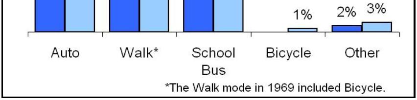
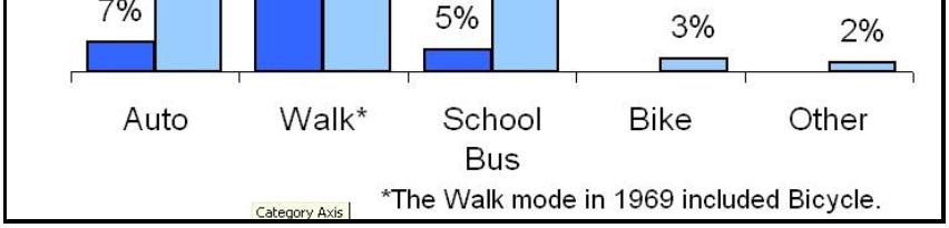
66 Changes in School Arrival Mode Graphic: Courtesy of National Center for Safe Routes to School 15 Changes in School Arrival Mode Graphic: Courtesy of National Center for Safe Routes to School 16 B-10
67 Stakeholders for School Traffic Walk to school is a big worry for parents It s only a minute from Jane Smith s home, but every morning she walks her son to his second-grade class. Smith and other parents who escort their children to the school say it s too risky to let them walk on makeshift paths during rush-hour traffic. 18 B-11
68 Texas Student Population 4,874, ,224,916 Source: Texas Education Agency, Enrollment in Public Schools, Texas Student Population ,617 new students Up over 21% Source: Texas Education Agency, Enrollment in Public Schools, B-12


69 Dallas ISD Student Population school year 157, students ,103 (-2.5%) 154 elementary 71 secondary 21 Region 10/11 Service Centers Source: Texas Education Agency, Enrollment in Public Schools, B-13


70 School Construction: US (K-12 Facilities) $13.4 Billion Source: School Planning & Management The 2011 School Construction Report 23 School Construction: Texas $2 billion/year Texas leads Photo: Courtesy of TTI 24 B-14


71 School Construction: Dallas ISD Voters approved $1.35B bond in May 2008 New schools: 8 Elementary 4 Middle 2 High Additions: campuses 19 science 6 campuses Renovations: $521 million 200 schools Source: Dallas ISD- Bond Program Page 25 Type School Type & Size Typical Grades Avg. Size 1 Biggest Local Elementary K Secondary Source: National Center for Education Statistics Growth in Size of Texas Schools: to Type # of Students % Increase 2 Elementary Middle High 2, Source: TEA, School Size & Class Size in Texas Public Schools 26 B-15


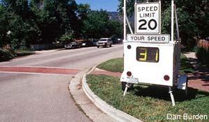
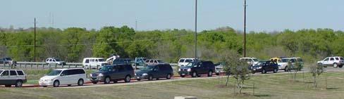
72 Typical Problem: Speeding 27 Typical Problem: Queue Spillback Photo: Courtesy of TTI Photo: Courtesy of TTI Photo: Courtesy of TTI 28 B-16


73 Typical Problem: Pedestrian/Bicycle Safety Source: UK Department of Transport Traffic Advisory Leaflet 7/93 (TAU, 1993) Photos: Courtesy of Joel Cranford, North Carolina DOT 29 Other Typical Problems? B-17

74 Existing TxDOT Programs: Safe Routes to School 31 Existing TxDOT Programs: Safe Routes to School Federally funded Texas distributed $54.1 million to fund 200 projects in more than 73 communities Infrastructure projects Construction project to improve bike/ped. safety in K-8 within 2-mile radius of school Non-infrastructure project Activities to encourage walking and bicycling to school Local examples: Sidewalks, curb ramps, and school zone flashers, pedestrian bridge improvements, and SRTS program development 32 B-18


75 Existing TxDOT Program: Precious Cargo Source: Texas Transportation Institute, Precious Cargo program materials 33 Existing TxDOT Program: Precious Cargo Source: Texas Transportation Institute, Precious Cargo program materials 34 B-19
76 Stakeholders Module Review Typical Problems Existing Programs: MODULE 3 SITE-BASED GUIDANCE 36 B-20


77 Learning Outcomes At the completion of this workshop module, you will be able to: Identify school site guideline categories Detect problems using a checklist Develop suggestions for improving i internal school site design and layout 37 Site Guideline Categories Site selection General site requirements and design Bus-related design and operations Parent zone design and operations Pedestrian and bicycle Access driveways Turning lanes On-site traffic control Parking 38 B-21
78 Site Selection Guidelines Location Where to put new schools? Accessibility How are students going to get to the site? Site size How big does the site need to be to handle all needs, including transportation? Building setback How is the building situated on the property? 39 School Location Challenges with: High speed Rural/suburban Frontage roads Railroads Source: TTI, report Better sites: Neighborhood Connectivity Source: TTI, report 40 B-22


79 LOCATION: Avoid locations with direct access to high speed roadways. Example to avoid Site Site with new school Photo: Courtesy of TTI Photo: Courtesy of TTI New school is planned for a site located on a high-speed two-lane roadway with no turning lanes. This is a typical example of a situation that is becoming more common in Texas, particularly in suburbs located on the fringe of rapidly growing metropolitan areas. 41 ACCESSIBILITY: Provide access from more than one direction to the immediate vicinity of the site, and provide access to the site from at least two adjacent streets. Example to avoid Good example 1 1 School on right has access from more than one direction (west and south) while the school on the left only has access from the north 2 42 B-23


80 ACCESSIBILITY: Site should be situated where the road alignment provides good visibility. Example to avoid Good example Photo: Courtesy of TTI Photo: Courtesy of TTI Driveway located only 150 feet from sharp Horizontal curve inadequate sight distance. Photo: Courtesy of TTI Views looking both directions from driveway adequate sight distance. 43 SITE SIZE: Recommended minimum site sizes based on the Council of Educational Facility Planners International guidelines. School Type Number of Acres Required Elementary (K 6) 10 1 Middle (5 8) 20 1 Junior High (7 9) 20 1 Senior High (9 12) 30 1 Vocational Center Plus one acre per 100 students on maximum projected enrollment 44 B-24


81 BUILDING SETBACK: School buildings should be setback on the site a sufficient distance from adjacent roadways to ensure safe & adequate site storage for stacking of loading & unloading vehicles. Example to avoid Good example School on right has ~ 350ft more stacking space by being pushed back (Rockwall ISD) 45 Prototype School Example to avoid Mansfield ISD Good example Front: 275 ft of storage Back: 1100 ft of storage Front: 630 ft of storage Back: 1300 ft of storage 46 B-25


82 General Site Requirements and Design Separation of transport modes How to keep them apart? Service, delivery & maintenance issues Where do they occur? Emergency access What are local fire codes and standards? Weather protection When is it provided? General site design How and when are site plans coordinated and reviewed? 47 SEPARATION: The physical routes provided for the basic modes (buses, cars, pedestrians/bicycles) of the traffic pattern should be separated as much as possible from each other. Example to avoid Good example Photo: Courtesy of TTI Photo: Courtesy of TTI Cars Buses Buses-only 48 B-26


 49")

83 Methods to Accomplish Separation of Modes Physical Design Access control/restrictions Signing/marking/gates Grade-level Photo: Courtesy of TTI Photo: Courtesy of TTI Temporal Hold back walkers and cyclists until all private vehicle pick-ups are complete (ensures no conflicts) Release walkers and cyclists first and hold back vehicle pick-ups (encourages walking and biking) 49 Aerial Photos Illustrating Separation of Modes Example to avoid Good example Bus + Parent Bus Shared exit Parent 50 B-27


84 WEATHER PROTECTION: All primary building entrances for students shall be weather protected by overhead cover or soffit. Good example Photo: Courtesy of TTI Covered walkway adjacent to the parent loading zone (Keller ISD) 51 GENERAL SITE: The site and proposed plans should be reviewed by the proper roadway agency. Good example 52 B-28


85 Site Plan Checklist Example Guideline # Review Question Answer Yes No Comments 1 Is the building setback a sufficient distance to provide adequate site storage? 4 Is the school site situated where the road alignment provides good visibility? 5 Are the physical routes provided for the basic modes separated from each other? 9 Is there adequate driveway stacking length for lining up vehicles on site? Etc. Etc. 53 Bus Operations: Staging Method Single file right wheel to the curb is the preferred staging method for buses. Example to avoid Good example Photo: Courtesy of TTI Photo: Courtesy of TTI Potential conflict areas between buses 54 B-29


86 Parent Drop-Off/Pick-Up Zone Design & Operations Guidelines No backward movement by vehicles One-way in counterclockwise direction Loading location Loading space Loading method On-site stacking length Minimize i i pedestrian-vehicle conflicts Student safety patrols 55 LOADING SPACE: Maximize fronting curb space as loading zone. Example to avoid Photo: Courtesy of Joel Cranford, North Carolina DOT 56 B-30


87 LOADING LOCATION: Students should be unloaded on the right side directly to the curb/sidewalk. Examples to avoid Good examples Photo: Courtesy of TTI Photo: Courtesy of TTI Photo: Courtesy of TTI Photo: Courtesy of TTI 57 LOADING LOCATION: Loading should occur in designated zones to minimize pedestrian/vehicle conflicts. Examples to avoid Photo: Courtesy of TTI Photo: Courtesy of TTI Photo: Courtesy of TTI Photo: Courtesy of TTI 58 B-31


88 LOADING METHOD: Student safety patrols can be used to assist children in and out of vehicles and should wear safety vests to provide visibility. Example to avoid Good example Photo: Courtesy of TTI Photo: Courtesy of TTI 59 LOADING METHOD: Single lane queues minimize pedestrian/vehicle conflicts. Example to avoid Good examples Photo: Courtesy of TTI Photo: Courtesy of TTI Photo: Courtesy of TTI 60 B-32
 400 750 750 1500 500 800 800 1600 400 800 800 1200 800 2500 1200 1500 Note: For high school populations greater than 2500, consider two separate student drop-off/pick-up")
89 Parent Zone: Stacking Lengths *** Objective = store all school traffic on-site *** School Type Elementary Middle ** High ** Student Population Less than or more Less than or more Loop Drive Stacking Length (ft) Note: For high school populations greater than 2500, consider two separate student drop-off/pick-up loops 61 Parent Zone: Stacking Lengths 55 Elementary schools in Texas Rule-of-thumb: Maximum queue length (veh.) = 6% of student enrollment Source: D. Qualls, Strategies for the Greening of Student Pick-up During School Dismissal, January B-33


90 Case Study: Landholt E.S. Clear Creek ISD, Friendswood Eliminate off-site vehicle queue Study by Existing conditions (2007) Enrollment = 1,200 students On-site storage for 8 vehicles in queue Max. observed queue = 82 vehicles Through lanes of Eldorado Blvd. (adjacent major arterial) blocked repeatedly Source: D. Qualls, Strategies for the Greening of Student Pick-up During School Dismissal, January Case Study: Landholt E.S. Clear Creek ISD, Friendswood Source: D. Qualls, Strategies for the Greening of Student Pick-up During School Dismissal, January B-34


91 Pedestrian and Bicycle Guidelines Provide safe crosswalks with crossing guards Do you have enough bikes and walkers? Standard and well-maintained sidewalks and/or a designated safe path leading to the school Where and are they needed? Provide bicycle access and storage facilities What are design standards? Pedestrians should not have to cross school drives to reach the school building 65 SAFE CROSSWALKS: Provide safe crosswalks with crossing guards. Examples to avoid Good examples Photo: Courtesy of Joel Cranford, North Carolina DOT Photo: Courtesy of Joel Cranford, North Carolina DOT Photo: Courtesy of Joel Cranford, North Carolina DOT Photo: Courtesy of Joel Cranford, North Carolina DOT 66 B-35


92 SIDEWALKS: There should be standard and well-maintained sidewalks and/or a designated safe path leading to the school. Example to avoid Good example Photo: Courtesy of Joel Cranford, North Carolina DOT Photo: Courtesy of Joel Cranford, North Carolina DOT 67 Guidelines for School Access Driveways Number How many driveways are needed for each school type? Spacing How far apart do they need to be? Location What is the proximity to intersections? Layout and design What are design standards? Source: TxDOT Access Management Manual, B-36


93 NUMBER OF DRIVEWAYS: Recommended number of driveways to adequately service the school site. School Type Number of Driveways Elementary 2 3 Middle 2 High 3-4 Sources: TTI report, South Carolina DOT Guidelines for School Transportation Design, 69 School Driveways: Number Photo: Courtesy of Joel Cranford, North Carolina DOT 4 Source: NorthCarolina_STI5.pdf 70 B-37
94 School Driveways: Number Photo: Courtesy of Joel Cranford, North Carolina DOT Source: NorthCarolina_STI5.pdf 71 DRIVEWAY SPACING: The spacing between school access driveways should desirably be 300 feet with 600 feet being desirable for left-turn lane development. Example to avoid Photo: Courtesy of Joel Cranford, North Carolina DOT 72 B-38

95 DRIVEWAY LOCATION: School driveways should conform with the minimum offset distances to the nearest intersection contained in state or local access management guidelines or manuals.? School Site 73 Source: TxDOT Access Management Manual, B-39
 Two lanes on exit driveways Photo: Courtesy of TTI Photo: Courtesy of TTI 75 SCDOT")

96 DRIVEWAY DESIGN AND LAYOUT Minimum turning radius 25 foot minimum for cars 40 foot minimum for buses Intersection angle 75 to 90 degrees Recommended lane widths 12 feet (increase on curves) Two lanes on exit driveways Photo: Courtesy of TTI Photo: Courtesy of TTI 75 SCDOT Driveway Designs Two-Way Car Drive Two-Way Bus Drive 12' 12' 12' 12' 12' 50' Taper 50' Taper 25' R Min. 18' 25' R Min. 40' R Min. 18' 40' R Min. 12' 18' Source: South Carolina DOT Guidelines for School Transportation Design Available: 76 B-40


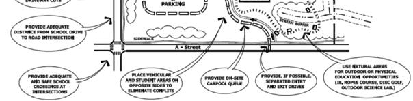
97 Elementary School Site Design Diagram Source: Public Schools of North Carolina The School Site Planner, Feb Middle School Site Design Diagram Source: Public Schools of North Carolina The School Site Planner, Feb B-41


98 High School Site Design Diagram Source: Public Schools of North Carolina The School Site Planner, Feb Categories Module Review Site plan review checklist Site plan review exercise: B-42
99 MODULE 4 ZONE-BASED GUIDANCE 81 Learning Outcomes At the completion of this workshop module, you will be able to: Understand procedures for school speed zones Discuss common school zone problems and issues List conditions for school zone removal 82 B-43


100 Overview of Zone Guidelines Goal: comparable traffic situations treated in consistent manner Guidelines Provide additional background Discuss issues/concerns Present typical examples Do not establish policy Photo: Marcus Brewer, TTI Photo: Marcus Brewer, TTI 83 Organization of Zone Guidelines Introduction School Location Definitions iti School Area Photo: Marcus Brewer, TTI School Speed Limit Zone School Speed Limit Zone Characteristics School Pavement Markings School Marked Crosswalk School Entrance Warning Conditions for Removing a School Speed Zone 84 B-44

101 Definitions for Zone Guidelines School = location where children in grades from kindergarten through the 12 th grade receive academic instructions Other definitions, including: School zone School speed limit zone School buffer zone 85 Observations of School- Area Traffic 86 B-45
102 Observations of School- Area Traffic 87 Observations of School- Area Traffic School Speed Limit 85 th Percentile Speed B-46
103 Observations of School- Area Traffic 89 Documents TxDOT: Procedures for Establishing Speed Zones (Nov 2006) TxDOT: Texas Manual on Uniform Traffic Control Devices (2006) FHWA: Manual on Uniform Traffic Control Devices (2009) 90 B-47
 Chapter 3, Section 3 Developing Strip Maps (Schools) 91 TxDOT: PESZ Chapter 2, Section 4 General No")

104 TxDOT: Procedures for Establishing Speed Zones (PESZ) Chapter 2, Section 4 School Speed Zones Chapter 3, Section 4 Speed Zone Design (Zone Length) Chapter 3, Section 3 Developing Strip Maps (Schools) 91 TxDOT: PESZ Chapter 2, Section 4 General No specific warrants or guidelines When children are going to and from school Consider irregular traffic and pedestrians Pedestrian crossing activity should be primary basis for reduced school speed zones Brief discussion on signs, with references to TMUTCD 92 B-48

105 TxDOT: PESZ Buffer Zone Source: TxDOT Procedures for Establishing Speed Zones, Figure TxDOT: PESZ Operation of Buffer Zones In some cases it may be appropriate to operate the buffer zone during the same time periods as the school speed zone. appropriate to have a school transition speed zone of 55 mph that flashes on the approach and departure side of the 35-mph school zone. 94 B-49
 20 590 775 30 584 1600 35 w/o 1454-2779 35 w/buffer 3818-6534 95 TxDOT: PESZ Chapter 3, Section 3 Strip Maps Selecting speed: Factual studies, reason, and sound engineering judgment,")
106 TxDOT: PESZ Chapter 3, Section 4 Length as short as reasonable School Speed in urban areas Urban areas with 30 mph As short as 200 to 300 ft No guidance for rural areas Limit (mph) Range of School Zone Length (ft) w/o w/buffer TxDOT: PESZ Chapter 3, Section 3 Strip Maps Selecting speed: Factual studies, reason, and sound engineering judgment, rather than emotion, should govern the final decision Not advisable to set above 35 mph in either rural or urban area 96 B-50


107 TxDOT: PESZ Chapter 3, Section 3 Strip Maps 85% speed Suggested < 55 mph Not more than 15 mph below 85th or normal posted speed limit 55 mph 20 mph below 85 th (35 mph) > 55 mph Use buffer zone to transition to 35 mph 97 TMUTCD and MUTCD Similar, some differences 98 B-51


108 TMUTCD and MUTCD Reduced speed zone starting point 99 TMUTCD and MUTCD TMUTCD does not include: Reduced Speed School Zone Ahead End School Zone Sign 100 B-52


109 TMUTCD and MUTCD TMUTCD includes School Speed Limit Markings Photo: Marcus Brewer, TTI 101 TMUTCD and MUTCD TMUTCD includes Overhead School Speed Limit Sign All Day plaque 102 B-53


110 TMUTCD and MUTCD MUTCD mandates FYG signs; TMUTCD mandates yellow, allows FYG as an option All example school signs in TMUTCD are shown in FYG 103 Review of Other States Practices 104 B-54
111 Use of SSL In Rural Areas Alaska and Florida Use beacons to increase conspicuity Massachusetts School zone not less than 850 ft Illinois Use larger signs on higher speeds Texas SSL = 35 mph 105 When to Install? Arizona and Utah Point system for school crossing warrants Average Time Between Gaps 85 th Percentile Approach Speed School Age Pedestrian Volume Average Demand Per Gap 106 B-55


112 When to Install? Summary Children present Children crossing Insufficient gaps Pedestrian demand per gap School enrollment Presence of crossing guards School abutting roadway Fence around school property Sidewalk presence Signal/stop control School grades 107 School Speed Limit Zone School speed limit zone considered for: School-age pedestrians crossing major roadway School located adjacent to highway or visible from highway Not typically used at: Stop-controlled intersections Signals Photo: Marcus Brewer, TTI 108 B-56
 (ft) 20 200 200 300 35 400 110")
113 Typical Signing and Marking * * Sign combination proposed 109 Begin School Speed Limit Zone 2006 TMUTCD: 200 ft to crosswalk or first driveway 2009 MUTCD: 200 ft, more if 30+ mph Research suggests changes have distance be a function of school speed limit School Speed Distance Limit (mph) (ft) B-57
114 Zone Length Research Speeds: 1 mph higher for every 500 ft driven Therefore, longer school zones associated with greater speed variability within zone Measured braking at school zones were used to determine recommendation for buffer zones 111 Zone Length Urban areas zones may be as short as 400 ft (d1 = 200 ft) 112 B-58
 113 School")

115 Zone Length Rural areas longer zones than urban, suggested length = 1,000 ft (d1 = 500 ft) 113 School Buffer Zone Recommended distance (d2, d5) 500 ft Overall, adds 1000 ft to reduced speed zone * Sign combination proposed 114 B-59
116 School Speed Limit Duration (Active Times) PESZ AM: 45 min before start of school to 0 min after PM: 0 min before end of school to 30 min after Observed AM: min before start; 0-75 min after PM: min before end; 0-75 min after 115 School Speed Limit Duration (Active Times) Research Findings Speeds lowest close to start/end t/ time of school 20 min before/after start time speeds 1 mph higher Recommended AM: 30 min before start to 5 min after beginning to end of the lunch period PM: 5 min before end to 30 min after 116 B-60
 based on posted speed limit 25 mph: 225 ft 70 mph: 1200 ft 118")
117 School Area Zone No reduced speed limit Length (d) based on posted speed limit 25 mph: ft 70 mph: ft 117 School Entrance Warning No reduced speed limit Length (d) based on posted speed limit 25 mph: 225 ft 70 mph: 1200 ft 118 B-61

118 Conditions for Removing Zone Can be considered if: Installation of signal or all-way stop Addition of turn bay(s) Correction of sight distance concern Changes in pedestrian walking pattern Changes in bus ridership 119 Module Review School zone definitions Guidelines for installation and removal Current guidance documents in Texas: B-62
BIKE PLAN CONTENTS GATEWAY
 CONTENTS Acknowledgments...vii Great Rivers Greenway District Board of Directors... vii Great Rivers Greenway District Staff... vii Project Consultants... vii Committees... viii Citizens Advisory Committee
GUIDELINES FOR USING DECISION SIGHT DISTANCE AT IGNALIZED INTERSECTIONS NEAR VERTICAL CURVES
 1. Report No. FHWA/TX-05/0-4084-P2 4. Title and Subtitle 2. Government Accession No. 3. Recipient's Catalog No. GUIDELINES FOR USING DECISION SIGHT DISTANCE AT IGNALIZED INTERSECTIONS NEAR VERTICAL CURVES
Texas Transportation Institute The Texas A&M University System College Station, Texas
 1. Report No. FHWA/TX-05/0-4084-P1 4. Title and Subtitle GUIDELINES FOR THE USE OF COUNTERMEASURES TO REDUCE CRASHES ON APPROACHES TO SIGNALIZED INTERSECTIONS NEAR VERTICAL CURVES 2. Government Accession
Stakeholder Communication and Public Involvement Plan
 Stakeholder Communication and Public Involvement Plan Arkansas Statewide Bicycle and Pedestrian Transportation Plan Plan purpose: The Arkansas State Bicycle and Pedestrian Plan will establish a framework
Implementing the Three Es of School Zone Traffic Calming
 Implementing the Three Es of School Zone Traffic Calming Use this evaluation tool as a guide to analyze the specific safety needs of your school. SCHOOL PROFILE School Name: School District: Address: Phone
IBPI: Bicycle and Pedestrian Education Program
 Portland State University PDXScholar Urban Studies and Planning Faculty Publications and Presentations Nohad A. Toulan School of Urban Studies and Planning 12-1-2010 IBPI: Bicycle and Pedestrian Education
Strategic Research PROGRAM FOLLOW-UP ASSESSMENT OF THE MOBILEYE SHIELD+ COLLISION AVOIDANCE SYSTEM
 165610-1 Strategic Research PROGRAM FOLLOW-UP ASSESSMENT OF THE MOBILEYE SHIELD+ COLLISION AVOIDANCE SYSTEM March 2017 1. Report No. TTI/SRP/17/165610-1 2. Government Accession No. 3. Recipient's Catalog
Traffic Calming Policy
 Article I. Purpose and Goal. The purpose of this policy is to establish criteria and procedures the City will use to evaluate requests for, and if appropriate, implement traffic calming measures. Neighborhood
Texas Intersection Safety Implementation Plan Workshop JUNE 2, 2016
 Texas Intersection Safety Implementation Plan Workshop JUNE 2, 2016 Why Intersection Safety? A small part of overall highway system, but Each year roughly 50% of all crashes estimated 3 million involve
CHAIR AND MEMBERS CIVIC WORKS COMMITTEE MEETING ON APRIL 25, 2016
 TO: FROM: SUBJECT: CHAIR AND MEMBERS CIVIC WORKS COMMITTEE MEETING ON APRIL 25, 2016 JOHN BRAAM, P. ENG. MANAGING DIRECTOR, ENVIRONMENTAL & ENGINEERING SERVICES AND CITY ENGINEER SCHOOL ZONE SPEED LIMIT
University of Victoria Campus Cycling Plan Terms of Reference. 1.0 Project Description
 University of Victoria Campus Cycling Plan Terms of Reference 1.0 Project Description The Campus Cycling Plan, a first for the University, will provide a comprehensive and coordinated approach to support
Exhibit 1 PLANNING COMMISSION AGENDA ITEM
 Exhibit 1 PLANNING COMMISSION AGENDA ITEM Project Name: Grand Junction Circulation Plan Grand Junction Complete Streets Policy Applicant: City of Grand Junction Representative: David Thornton Address:
Closing Plenary Session
 TRAFFIC SAFETY CONFERENCE Closing Plenary Session June 9, 2017 Las Colinas, TX Order of Report Out June 9, 2017 Las Colinas, TX Distracted Driving Prioritized Countermeasures Countermeasure 4a Systemically
Bicycle Master Plan Goals, Strategies, and Policies
 Bicycle Master Plan Goals, Strategies, and Policies Mobilizing 5 This chapter outlines the overarching goals, action statements, and action items Long Beach will take in order to achieve its vision of
Pedestrian Treatments by
 Pedestrian Treatments by Kay Fitzpatrick Texas A&M Transportation Institute TxDOT Short Course October 15-16, 2013 Recent Research Efforts FHWA Studies Crosswalk markings Driver yielding (DY) at rectangular
MnDOT Implementation of Complete Streets Policy. January 2014
 MnDOT Implementation of Complete Streets Policy January 2014 1 Prepared by Minnesota Department of Transportation 395 John Ireland Boulevard Saint Paul, Minnesota 55155-1899 Phone: 651-296-3000 Toll-Free:
CITY OF ANN ARBOR TRAFFIC CALMING PROGRAM PROCESS OVERVIEW. Petitioner defines the project area limits and gathers petition signatures.
 CITY OF ANN ARBOR TRAFFIC CALMING PROGRAM PROCESS OVERVIEW Step 1: Petition Petitioner defines the project area limits and gathers petition signatures. 50% of addresses within the project area must sign
FHWA Resources for Pedestrian and Bicycle Professionals
 FHWA Resources for Pedestrian and Bicycle Professionals Charlie Zegeer, UNC Highway Safety Research Center/PBIC Libby Thomas, UNC Highway Safety Research Center Dan Nabors, Vanasse Hangen Brustlin (VHB)
Tulsa Metropolitan Area LONG RANGE TRANSPORTATION PLAN
 Tulsa Metropolitan Area LONG RANGE TRANSPORTATION PLAN Indian Nations Council of Governments August 2005 CONTACTING INCOG In developing the Destination 2030 Long Range Transportation Plan, INCOG s Transportation
Pedestrian Safety Initiatives National Highway Traffic Safety Administration (NHTSA)
") Pedestrian Safety Initiatives National Highway Traffic Safety Administration (NHTSA) Report to the Transportation Research Board Pedestrian Safety Committee January 2010 Leah Walton Safety Countermeasures
Pedestrian Safety Initiatives National Highway Traffic Safety Administration (NHTSA) Report to the Transportation Research Board Pedestrian Safety Committee January 2010 Leah Walton Safety Countermeasures
REGIONAL SAFETY ADVISORY COMMITTEE North Central Texas Council of Governments Transportation Council Room Friday, October 26, :00 am AGENDA
 REGIONAL SAFETY ADVISORY COMMITTEE North Central Texas Council of Governments Transportation Council Room Friday, October 26, 2018 10:00 am AGENDA 1. Approval of August 24, 2018 Meeting Summary Matt Hotelling,
Automated Traffic Enforcement Technology Guidelines
 Automated Traffic Enforcement Technology Guidelines Province of Alberta (September 2014) Revised Automated Traffic Enforcement Technology Guidelines Province of Alberta A. PREAMBLE Automated traffic enforcement
School Traffic Concerns?
 Dealing with Texas-Sized Problems around Schools 2006 TexITE Summer Meeting June 25, 2006 Scott A. Cooner, P.E. Associate Research Engineer Texas Transportation Institute School Traffic Concerns? Parents
The Florida Bicycle and Pedestrian Partnership Council
 The Florida Bicycle and Pedestrian Partnership Council Input to the Update of the Florida Transportation Plan March 2015 This document presents input from the Florida Bicycle and Pedestrian Advisory Council
5. Pedestrian System. Accomplishments Over the Past Five Years
 5. Pedestrian System Accomplishments Over the Past Five Years The Alamo Area Metropolitan Planning Organization (MPO) and its partner agencies recognize the importance of improving pedestrian mobility.
City of Elizabeth City Neighborhood Traffic Calming Policy and Guidelines
 City of Elizabeth City Neighborhood Traffic Calming Policy and Guidelines I. Purpose: The City of Elizabeth City is committed to ensure the overall safety and livability of residential neighborhoods. One
NEIGHBORHOOD TRAFFIC CALMING POLICY
 NEIGHBORHOOD TRAFFIC CALMING POLICY I. PURPOSE The City of Kent continually strives to strengthen and protect its neighborhoods by improving the quality of life in residential areas. Traffic conditions
SHSP Action Plan Development. Intersection EA Team
 SHSP Action Plan Development Intersection EA Team March 7, 2018 Agenda Welcome and Introductions Review Completed Action Plans Developed by Working Groups Next Steps STRATEGIES: INTERSECTION SAFETY EMPHASIS
The 2009 Manual on Uniform Traffic Control Devices (MUTCD) (Brief) Highlights for Arizona Practitioners. Arizona Department of Transportation
 (Brief) Highlights for Arizona Practitioners. Arizona Department of Transportation") The 2009 Manual on Uniform Traffic Control Devices (MUTCD) (Brief) Highlights for Arizona Practitioners Arizona Department of Transportation New 2009 MUTCD 9 Parts (down from 10 in 2003) 816 pages (up
The 2009 Manual on Uniform Traffic Control Devices (MUTCD) (Brief) Highlights for Arizona Practitioners Arizona Department of Transportation New 2009 MUTCD 9 Parts (down from 10 in 2003) 816 pages (up
Toward Zero Deaths. Regional SHSP Road Show Meeting. Virginia Strategic Highway Safety Plan. presented by
 Toward Zero Deaths Regional SHSP Road Show Meeting presented by Virginia Strategic Highway Safety Plan December 1, 2016 1 Welcome & Introductions Purpose of the Meeting Objectives & Key Outcomes Agenda»
Display Boards Including Five Refined Design Concepts
 APPENDIX D Workshop Session 3 Sign-in sheets Agenda Booklet Display Boards Including Five Refined Design Concepts PowerPoint Presentation Questions Recorded Discussion of Preference Exercise AGENDA
TOWN OF CHAPEL HILL POLICY AND PROCEDURES FOR TRAFFIC CALMING MEASURES
 TOWN OF CHAPEL HILL POLICY AND PROCEDURES FOR TRAFFIC CALMING MEASURES (Adopted by the Town Council on June 30, 2004) (Revised December 6, 2010) (Revised February 8, 2016) POLICY AND PROCEDURES FOR TRAFFIC
Bicycle and Pedestrian Connectivity Study Phase 2
 Connectivity Study Phase 2 Process PROCESS OUTCOMES Phase Prepared By STEP I Public Participation and Outreach 1. RTP Outreach activities, and development of the Bike and Ped Task Force Phase 1 2011 OCPC
Pedestrian Crosswalk Audit
 1200, Scotia Place, Tower 1 10060 Jasper Avenue Edmonton, Alberta T5J 3R8 edmonton.ca/auditor Pedestrian Crosswalk Audit June 19, 2017 The conducted this project in accordance with the International Standards
Access Management Regulations and Standards
 Access Management Regulations and Standards Efficient highway operation Reasonable property access Concept of Access Management The way to manage access to land development while simultaneously preserving
Attachment No. 13. National Committee on Uniform Traffic Control Devices RWSTC RECOMMENDATION FOLLOWING SPONSOR COMMENTS
 1 2 3 4 Attachment No. 13 5 6 7 8 9 10 11 12 13 14 15 16 17 18 19 20 21 22 23 24 25 26 27 28 29 30 31 32 33 34 35 36 37 38 39 40 41 42 43 RWSTC agenda item IV. 2 June 2011 National Committee on Uniform
TRAFFIC STUDY GUIDELINES Clarksville Street Department
 TRAFFIC STUDY GUIDELINES Clarksville Street Department 9/1/2009 Introduction Traffic studies are used to help the city determine potential impacts to the operation of the surrounding roadway network. Two
MEETING Agenda. Introductions. Project Overview. Key Study Components. Alternative Station Concepts. Preferred Station Concept. Next Steps.
 City GARLAND Council ROADVISION Briefing STUDY VISION STUDY Dallas, TX April 8, 2010 1 1 MEETING Agenda Introductions Project Overview Key Study Components Alternative Station Concepts Preferred Station
Traffic Calming Policy
 City of Friendswood Traffic Calming Policy May 2012 Community Development Department Table of Contents Title Page Table of contents... 1 Background and History... 2 Purpose and Goals... 2 City Procedure
Traffic Impact Study. Westlake Elementary School Westlake, Ohio. TMS Engineers, Inc. June 5, 2017
 TMS Engineers, Inc. Traffic Impact Study Westlake Elementary School Westlake, Ohio June 5, 2017 Prepared for: Westlake City Schools - Board of Education 27200 Hilliard Boulevard Westlake, OH 44145 TRAFFIC
VILLAGE OF NILES TRAFFIC CALMING POLICY
 INTRODUCTION There is increasing interest across the country in developing new strategies to reduce the speed and amount of traffic in residential neighborhoods. Measurement of speeds, traffic volumes,
Bicycle RSAs: How to Conduct Road Safety Audits and How to Use Them to Promote Bicyclist Safety. Dan Nabors, PE, VHB Bill DeSantis, PE, VHB
 PBIC Webinar Bicycle RSAs: How to Conduct Road Safety Audits and How to Use Them to Promote Bicyclist Safety [IMAGE] Dan Nabors, PE, VHB Bill DeSantis, PE, VHB Sept. 26, 2013, 2 pm Today s Presentation
Texas Intersection Safety Implementation Plan (ISIP): Project Overview & Preliminary Findings. April 15, 2016
: Project Overview & Preliminary Findings. April 15, 2016") Texas Intersection Safety Implementation Plan (ISIP): Project Overview & Preliminary Findings April 15, 2016 2 Introductions North Central Texas Council of Governments (Dallas Fort Worth area) Capital
Texas Intersection Safety Implementation Plan (ISIP): Project Overview & Preliminary Findings April 15, 2016 2 Introductions North Central Texas Council of Governments (Dallas Fort Worth area) Capital
PRELIMINARY DRAFT FIRST AMENDMENT TO VISION 2050: A REGIONAL LAND USE AND TRANSPORTATION PLAN FOR SOUTHEASTERN WISCONSIN
 PRELIMINARY DRAFT FIRST AMENDMENT TO VISION 2050: A REGIONAL LAND USE AND TRANSPORTATION PLAN FOR SOUTHEASTERN WISCONSIN ESTABLISHING TARGETS FOR FEDERAL PERFORMANCE MEASURES: HIGHWAY SAFETY SOUTHEASTERN
City of Charlottesville Bicycle and Pedestrian Master Plan Update
 City of Charlottesville Bicycle and Pedestrian Master Plan Update September 17, 2014 I. Welcome and meeting overview II. Project status update III. Network overview IV. Break-out groups Pedestrian Network
Cycling Master Plan Community Engagement Session WELCOME
 Cycling Master Plan Community Engagement Session WELCOME WHY COMMUNITIES PLAN Considering Short Term and Long Term Needs City of Lethbridge is committed to planning - to determine short term goals along
TRAVEL PLAN: CENTRAL EUROPEAN UNIVERSITY CAMPUS REDEVELOPMENT PROJECT TRAVEL PLAN. Central European University Campus Redevelopment Project.
 TRAVEL PLAN Central European University Campus Redevelopment Project Page 1 Table of Contents Introduction... 3 Background... 7 Building Users... 7 Transportation in Community Consultation... 7 Summary
Outline. TAMU Campus Projects TxDOT Innovative Research Project Mobileye Shield+ Pilot
 Outline TAMU Campus Projects TxDOT Innovative Research Project Mobileye Shield+ Pilot How Does Initiative Work? Campus Transportation Technology Initiative Solicit technology demonstrations via RFI process
New Brunswick Strategic Planning Proposal
 New Brunswick Strategic Planning Proposal Proposal Title: Rutgers University Crosswalk Enhancement Project Proposal Initiator: Rutgers University Division of Administration and Public Safety Executive
The Role of MPOs in Advancing Safe Routes to School through the Transportation Alternatives Program
 The Role of MPOs in Advancing Safe Routes to School through the Transportation Alternatives Program In 2012, Congress made changes to Federal funding for Safe Routes to School that gave some metropolitan
Double the amount of bicycle ridership while at the same time reducing the number of bicycle crashes by one-third.
 CHAPTER 6 Recommended Policies and Action Items To achieve the goals stated in Chapter 1 and guide implementation of the Bicycle Plan, policies and action items have been identified. They are presented
Corpus Christi Metropolitan Transportation Plan Fiscal Year Introduction:
 Introduction: The Safe, Accountable, Flexible, Efficient Transportation Equity Act: A Legacy for Users (SAFETEA-LU) has continued the efforts started through the Intermodal Surface Transportation Efficiency
By Kay Fitzpatrick, Ph.D., P.E., Ann Do, P.E., and Bruce Friedman, P.E.
 feature shutterstock.com/dieter Hawlan Rapid-Flashing Beacons for Pedestrian Treatments By Kay Fitzpatrick, Ph.D., P.E., Ann Do, P.E., and Bruce Friedman, P.E. The rectangular rapid-flashing beacon has
Table of Contents. I. Introduction 1. II. Elements of the School Crossing Program 1
 Table of Contents Page I. Introduction 1 II. Elements of the School Crossing Program 1 a. Identifying Locations Where School Crossing Guards are Needed 1 b. The Role of the School Crossing Guard 1 c. Hiring
WALKNBIKE DRAFT PLAN NASHVILLE, TENNESSEE EXECUTIVE SUMMARY NASHVILLE, TENNESSEE
 NASHVILLE, TENNESSEE EXECUTIVE SUMMARY Executive Summary A world-class multi-modal transportation system is essential to a vibrant city and better quality of life. -Mayor Barry The WalknBike plan aims
OTM Book 18 Cycling Facilities Update
 OTM Book 18 Cycling Facilities Update Wednesday, April 18 th, 2018 Ontario Bike Summit Cycling Design Concurrent Session WITH INASSOCIATION WITH Today s Discussion Point 1. Why is Book 18 being updated?
TEMPORARY TRAFFIC CONTROL GUIDELINES FOR HIGHWAY-RAIL GRADE CROSSINGS
 TEMPORARY TRAFFIC CONTROL GUIDELINES FOR HIGHWAY-RAIL GRADE CROSSINGS 1.0 INTRODUCTION 1.1 Purpose The Southern California Regional Rail Authority (SCRRA) is the designated track owner of the Metrolink
DEPARTMENT OF ENVIRONMENTAL SERVICES. North Harrison Street (Lee Highway to Little Falls Road) Comparative Analysis. Prepared for:
 Comparative Analysis. Prepared for:") DEPARTMENT OF ENVIRONMENTAL SERVICES North Harrison Street (Lee Highway to Little Falls Road) Comparative Analysis Prepared for: Arlington County Department of Environmental Services 2100 Clarendon Boulevard,
DEPARTMENT OF ENVIRONMENTAL SERVICES North Harrison Street (Lee Highway to Little Falls Road) Comparative Analysis Prepared for: Arlington County Department of Environmental Services 2100 Clarendon Boulevard,
Appendix B Warrants, Standards, and Guidelines for Traffic Control Devices used at Senior Citizen and Disabled Person Crossings
 Appendix B Warrants, Standards, and Guidelines for Traffic Control Devices used at Senior Citizen and Disabled Person Crossings B.1 General Minnesota Statute 169.215 and Highway Traffic Regulation 169.222
ADOT Statewide Bicycle and Pedestrian Program Summary of Phase IV Activities APPENDIX B PEDESTRIAN DEMAND INDEX
 ADOT Statewide Bicycle and Pedestrian Program Summary of Activities APPENDIX B PEDESTRIAN DEMAND INDEX May 24, 2009 Pedestrian Demand Index for State Highway Facilities Revised: May 29, 2007 Introduction
WEST AND SOUTH WEST RING ROAD DOWNSTREAM TRAFFIC IMPACTS
 Page 1 of 9 EXECUTIVE SUMMARY Alberta Transportation ( AT ) is preparing to construct the final sections of the Calgary Ring Road. This includes the South West Ring Road ( SWRR ) (from Lott Creek Blvd
Access Management Regulations and Standards for Minor Arterials, Collectors, Local Streets
 Access Management Regulations and Standards for Minor Arterials, Collectors, Local Streets September 2009 Paul Grasewicz Access Management Administrator Concept of Access Management The way to manage access
Agenda. Overview PRINCE GEORGE S PLAZA METRO AREA PEDESTRIAN PLAN
 PRINCE GEORGE S PLAZA METRO AREA PEDESTRIAN PLAN May 28, 2008 Agenda Welcome and introductions Project overview and issue identification Planning context and strengths Design challenges and initial recommendations
NOTES FROM JUNIOR COUNCIL ORIENTATION SESSION HELD ON MONDAY, JANUARY 22, 2018, AT 3:30 PM IN COUNCIL CHAMBERS, CITY HALL
 CITY OF KAMLOOPS Junior Council Meeting Agenda March 12, 2018, at 3:30 pm in Council Chambers, 7 Victoria Street West, Kamloops, BC Page 1. APPROVAL OF THE AGENDA 2. MINUTES Attachment Recommendation:
Proposed changes to Massachusetts MUTCD Supplement
 Proposed changes to Massachusetts MUTCD Supplement John F. Carr National Motorists Association October 24, 2002 This document contains recommendations as to the contents of the Massachusetts MUTCD supplement
CITY MANUALS AND STANDARDS REVIEW
 GEORGETOWN SIDEWALK MASTER PLAN CITY MANUALS AND STANDARDS REVIEW RESOURCES AND STANDARDS As part of the Master Plan process, a review and evaluation of current City documents and policies relevant to
City of Ann Arbor Pedestrian Safety & Access Task Force
 City of Ann Arbor Pedestrian Safety & Access Task Force (PSATF) Community Wide Meeting Wednesday, July 8th 6:30 to 8:30 PM Multi purpose Room, Downtown Library www.a2gov.org/pedsafety The Greenway Collaborative,
APPENDIX A: Complete Streets Checklist DRAFT NOVEMBER 2016
 APPENDIX A: Complete Streets Checklist DRAFT NOVEMBER 2016 Complete Streets Checklist MetroPlan Orlando s Complete Streets Checklist is an internal planning tool for staff to further implementation of
Texas Transportation Institute The Texas A&M University System College Station, Texas
 1. Report No. FHWA/TX-08/0-5446-2 4. Title and Subtitle DRIVER COMPREHENSION OF SIGNING AND MARKINGS FOR TOLL FACILITIES 2. Government Accession No. 3. Recipient's Catalog No. Technical Report Documentation
Railroad-Highway Grade Crossing Analysis for Corridor Planning Projects
 Railroad-Highway Grade Crossing Analysis for Corridor Planning Projects Word Count: 4,305 Submission Date: August 1, 2015 Author: Adriana Rodriguez, E.I Assistant Engineer Parsons Brinckerhoff 1420 South
Scope of Services BICYCLE/PEDESTRIAN PLAN FOR THE INDIAN RIVER COUNTY MPO
 I. INTRODUCTION Scope of Services BICYCLE/PEDESTRIAN PLAN FOR THE INDIAN RIVER COUNTY MPO The Indian River County Metropolitan Planning Organization (MPO) Bicycle and Pedestrian Plan was completed in 1997.
Durrance Elementary School
 Durrance Elementary School SCHOOL ROUTE PLAN For DURRANCE ELEMENTARY SCHOOL LOCATION 9 ORANGE COUNTY Prepared for: ORANGE COUNTY SCHOOL ASSESSMENT PROGRAM ORANGE COUNTY PUBLIC WORKS Traffic Engineering
Chapter PERFORMANCE MEASURES AND ACCOUNTABILITY. Introduction
 PERFORMANCE MEASURES AND ACCOUNTABILITY Introduction Performance measures are helpful in evaluating the progress being made toward achieving the goals and objectives of the Gateway Bicycle Plan. The Plan
NCTCOG 16-County Crash and Fatality Data
 North Central Texas Council of Governments - Traffic Safety Crash and Fatality Statistics NORTH CENTRAL TEXAS COUNCIL OF GOVERNMENTS (NCTCOG) 2012 Safety Program Performance Measures NCTCOG 16-County Crash
RURAL HIGHWAY SHOULDERS THAT ACCOMMODATE BICYCLE AND PEDESTRIAN USE (TxDOT Project ) June 7, Presented by: Karen Dixon, Ph.D., P.E.
 June 7, Presented by: Karen Dixon, Ph.D., P.E.") RURAL HIGHWAY SHOULDERS THAT ACCOMMODATE BICYCLE AND PEDESTRIAN USE (TxDOT Project 0-6840) June 7, 2016 Presented by: Karen Dixon, Ph.D., P.E., TTI Team: Kay Fitzpatrick, Raul Avelar, & Subasish Das Project
RURAL HIGHWAY SHOULDERS THAT ACCOMMODATE BICYCLE AND PEDESTRIAN USE (TxDOT Project 0-6840) June 7, 2016 Presented by: Karen Dixon, Ph.D., P.E., TTI Team: Kay Fitzpatrick, Raul Avelar, & Subasish Das Project
Meeting Summary Public Information Meeting #1 Warren County Pathway Corridor Project September 27, 2018
 Meeting Summary Public Information Meeting #1 Warren County Pathway Corridor Project September 27, 2018 The first public information meeting for the Warren County Pathway Corridor Project was held on Thursday,
A Traffic Operations Method for Assessing Automobile and Bicycle Shared Roadways
 A Traffic Operations Method for Assessing Automobile and Bicycle Shared Roadways A Thesis Proposal By James A. Robertson Submitted to the Office of Graduate Studies Texas A&M University in partial fulfillment
NCUTCD Proposal for Changes to the Manual on Uniform Traffic Control Devices
 1 2 3 4 5 6 7 NCUTCD Proposal for Changes to the Manual on Uniform Traffic Control Devices Attachment No.: 2 Item # 18B-RW-02 8 9 10 11 12 13 14 15 16 17 18 19 20 21 22 23 24 25 26 27 28 29 30 31 TECHNICAL
City of Novi Non-Motorized Master Plan 2011 Executive Summary
 City of Novi Non-Motorized Master Plan 2011 Executive Summary Prepared by: February 28, 2011 Why Plan? Encouraging healthy, active lifestyles through pathway and sidewalk connectivity has been a focus
Prioritizing Schools for Safe Routes to School Infrastructure Projects
 Prioritizing Schools for Safe Routes to School Infrastructure Projects Determining the most effective use of limited infrastructure funds is a challenging task. It is especially demanding for local transportation
Abstract. Background. protected/permissive operation. Source: Google Streetview, Fairview/Orchard intersection
 ITE 2015 Western District Annual Meeting Ada County Highway District s Flashing Yellow Arrow Initiative Primary Author: Tim Curns, PE Ada County Highway District Traffic Engineer Author: Andrew Cibor,
900 BICYCLE FACILITIES Traffic Engineering Manual
 TABLE OF CONTENTS Part 9 - BICYCLE FACILITIES 900 GENERAL... 9-3 900-1 General Background... 9-3 900-2 Designated Bicycle Routes... 9-3 901 SIGNINGS... 9-4 902 MARKINGS... 9-4 902-1 General... 9-4 902-2
12 RECOMMENDATIONS Road Improvements. Short Term (generally the next five years)
") 12 RECOMMENDATIONS Recommendations are based on the technical analysis of existing and future road and active transportation conditions, the results of the review of existing City policies and public feedback.
12 RECOMMENDATIONS Recommendations are based on the technical analysis of existing and future road and active transportation conditions, the results of the review of existing City policies and public feedback.
TOWN OF PARADISE VALLEY
 TOWN OF PARADISE VALLEY The Paradise Valley Bicycle & Pedestrian Master Plan Planning Commission January 16, 2018 Purpose of Today s Meeting Review January 2018 draft plan Input on compliance to SOD Review
Orange Center Elementary School
 Drag and drop pic and stretch/crop to the limits of the blue rectangle (delete this text box) Orange Center Elementary School Drag and drop pic and stretch/crop to the limits of the blue rectangle (delete
Bicyclist Signing Guidelines
 Bicyclist Signing Guidelines April, 2009 1 Introduction This paper describes the Montana Department of Transportation s (MDT) current practices related to bicyclist safety and signing issues and presents
VDOT BICYCLE & PEDESTRIAN IMPLEMENTATION GUIDE FOR LOCALITY INVOLVEMENT April 2017
 VDOT BICYCLE & PEDESTRIAN IMPLEMENTATION GUIDE FOR LOCALITY INVOLVEMENT April 2017 1 TABLE OF CONTENTS Topic Page(s) About this Guide 3 Encouraging development of bicycle and pedestrian plans by localities
Installation of Traffic Signals and Pedestrian Crossings
 SER-009-021 Strathcona County Municipal Policy Handbook Installation of Traffic Signals and Pedestrian Crossings Date of Approval by Council: 04/16/91; 06/12/2007 Resolution No. 325/91; 526/2007 Lead Role:
Meeting Agenda Marking Technical Committee National Committee on Uniform Traffic Control Devices January 19-20, 2011 Arlington, VA
 Meeting Agenda Marking Technical Committee National Committee on Uniform Traffic Control Devices January 19-20, 2011 Arlington, VA Draft agenda as of January 16, 2011 See MTC website at http://ceprofs.civil.tamu.edu/ghawkins/mtc.htm
City of Dallas Standards and Guidelines for Traffic Control and Safety Treatments at Trail-Road Crossings
 City of Dallas Standards and Guidelines for Traffic Control and Safety Treatments at Trail-Road Crossings Prepared by Max Kalhammer Senior Planner (Bicycle Coordinator) Strategic Planning Division Department
BETHEL ROAD AND SEDGWICK ROAD CORRIDOR STUDY
 DRAFT PLAN City Council Meeting August 14, 2017 STUDY AREA Sedgwick Corridor State Route 160, principal arterial with Class 3 access management designation, commuter and freight route, connection to SR
Bicycling Routes on Provincial Roads Policy
 Bicycling Routes on Provincial Roads Policy Policy Statement Rationale To support bicycling in Nova Scotia, the Department of Transportation and Infrastructure Renewal (TIR) may designate some portions
Traffic Engineering The Basics. Understanding the basic principles and how these drive the decisions regarding traffic management in Louisiana
 Traffic Engineering 101 - The Basics Understanding the basic principles and how these drive the decisions regarding traffic management in Louisiana Traffic Engineering 101 Purpose: To provide an overview
Transportation Curriculum. Survey Report
 Transportation Curriculum Survey Report Jennifer Dill, Ph.D. Lynn Weigand, Ph.D. Portland State University Center for Urban Studies Center for Transportation Studies Initiative for Bicycle and Pedestrian
Contents. Champaign-Urbana Mass Transit District Stop Placement Guidelines
 Contents Champaign-Urbana Mass Transit District Introduction... 1 Stop Spacing... 2 Rural... 2 Low Density Suburban... 2 General Urban... 2 Urban Core... 2 Operational Safety... 3 Stop Placement... 4 Nearside
CHAPTER 3: Vision Statement and Goals
 Davidson Walks & Rolls: Active Transportation Master Plan CHAPTER 3 Contents: Overview Vision Statement Measurable Goals Public Outreach CHAPTER 3: Vision Statement and Goals Overview The vision statement
CITY OF VISTA TRAFFIC CALMING PROGRAM
 CITY OF VISTA TRAFFIC CALMING PROGRAM The purpose of the Vista Traffic Calming Program is to reduce speeds of motorists driving through residential neighborhoods. The program does not apply to nonresidential
City of Ann Arbor Pedestrian Safety & Access Task Force
 City of Ann Arbor Pedestrian Safety & Access Task Force Community Wide Meeting #2 Wednesday, March 25 th 6:30 to 8:30 PM Multi-purpose Room, Downtown Library The Greenway Collaborative, Inc. www.greenwaycollab.com
Providing an Efficient and Multi-modal Transportation System
 Providing an Efficient and Multi-modal Transportation System Welcome and Introductions The Plan Process Transportation Overview Workshop Discussions Report Out and Next Steps AGENDA Comprehensive Plan
Town of Orangetown Neighborhood Traffic Calming Program
 Town of Orangetown Neighborhood Traffic Calming Program Table of Contents I Introduction a. Purpose b. Key to successful projects c. What is Traffic Calming? II III IV V VI VII Definitions Street Classification