Streetscape Report Streetscape Report FALL 2017
|
|
|
- Silvia Garrett
- 5 years ago
- Views:
Transcription

1 Streetscape Report Streetscape Report FALL 2017
2 EXECUTIVE SUMMARY The Streetscape Report's Plan Report is an effort to address community desires and recommendations related to the Tacoma Link Expansion streetscape development. The process is designed to assess community needs within the following categories: 1. Pedestrian Improvements, such as crosswalks, lighting, trees, and alley activation 2. Parking 3. Accommodation of local small business both during and after construction 4. Connection between the neighborhood and local employers 5. Various other concerns of local stakeholders The process draws from the previous "Housing Hilltop" Discovery Report and from additional community engagement meetings, where insight from residents and local businesses was directly solicited. The objective is to leverage the shared histories and insights of neighborhood residents, businesses, and local institutions to aid in the shaping of municipal improvements along the M.L.K. Jr. Way corridor expansion. Sound Transit will be continuing new light rail tracks and stations along M.L.K Jr Way. The city of Tacoma will be constructing new sidewalks and right of way where these tracks occur. This report proposes community recommended design improvements during that construction. 2
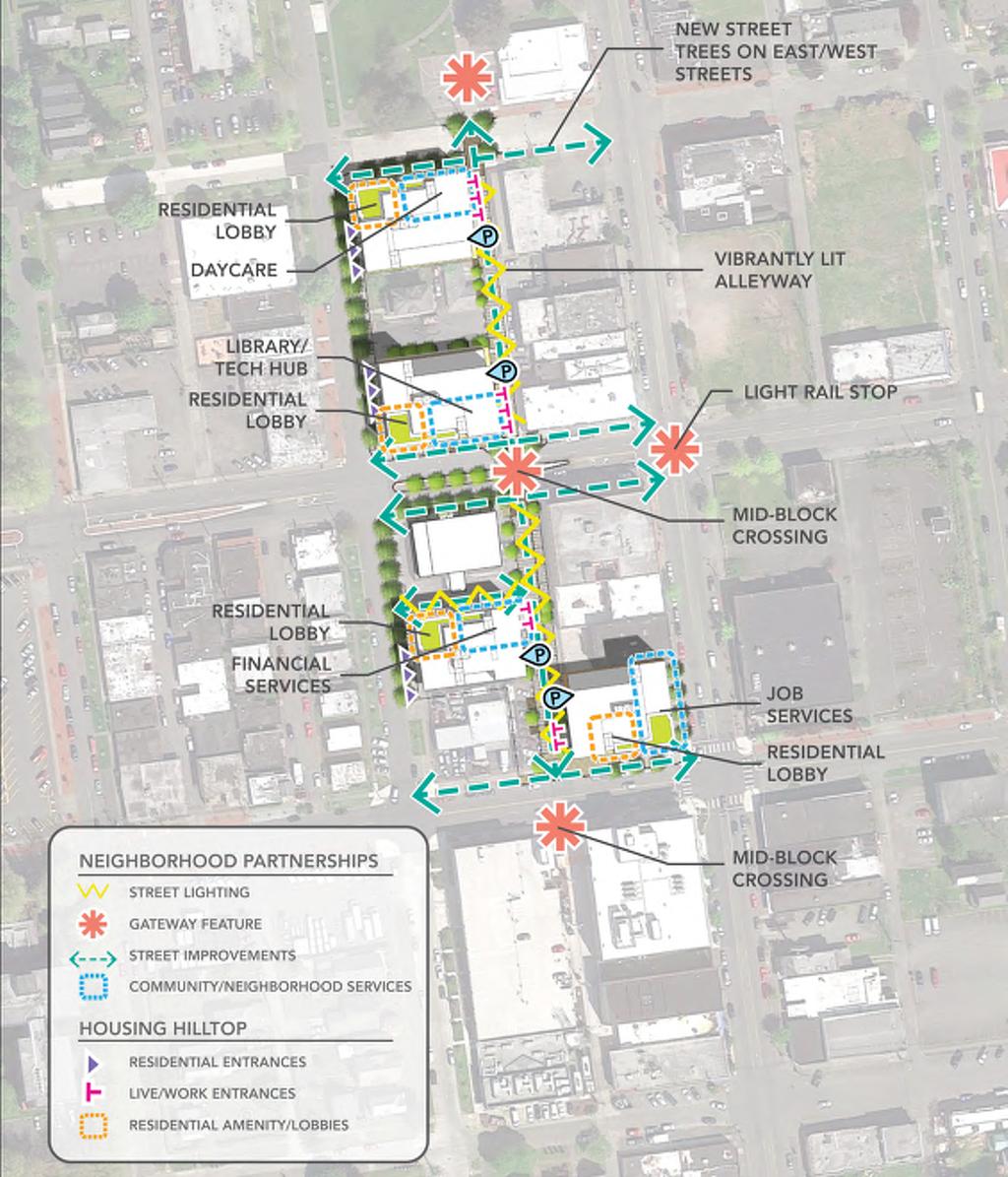
3 Streetscape Planning Area Links to Opportunity MLK & Division P! Stadium Business District P! Stadium District Stadium Way & S. 4th P! Evergreen State College-Tacoma MLK & 6th Avenue P! P! # Relocated Station Theater District (Relocate) MLK & S. 11th Street P! Hilltop Business District Bates Technical College # Commerce Street People's Community Center MLK & S. 19th Street P! St. Joseph Medical Center Downtown Regional Growth Center Convention Center # # Union Station ,000 2,000 Feet # South 25th # [ Sources: Esri, HERE, DeLorme, Intermap, increment Tacoma P Corp., Dome GEBCO, USGS, FAO, NPS, NRCAN, GeoBase, IGN, Kadaster NL, Ordnance Survey, Esri Japan, METI, Esri China (Hong Kong), swisstopo, MapmyIndia, OpenStreetMap contributors, and the GIS User Community Existing Tacoma Link Proposed link extension w/design of amenities such as way-finding signs and corridor connections Streetscape design alignment to follow Tacoma Link Expansion. Note: The lighter area around the link may be considered for complete streets elements (including but not limited to bicycle and pedestrian accommodations, amenities and way-finding signs. City of Tacoma, All Rights Reserved Community & Economic Development Department GIS Analysis & Data Service 6/28/2017 \\Geobase-win\CED\GADS\R2017\R315\Hilltop_LINKS_ mxd 3

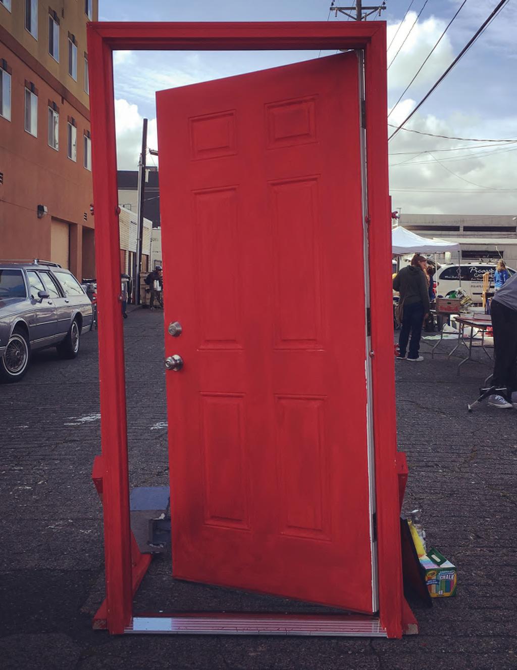
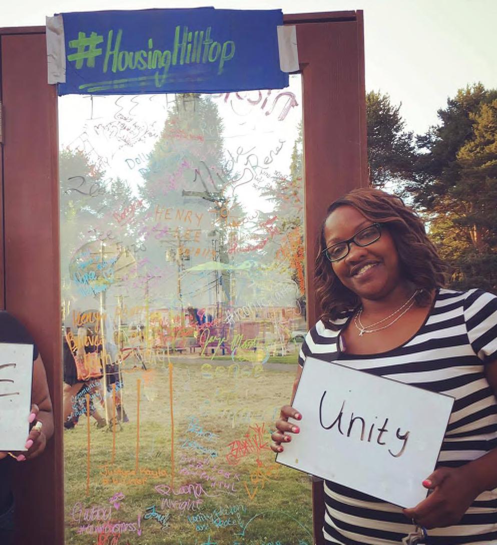
4 Housing Hilltop Performed prior to the Streetscape Report, the Housing Hilltop Discovery Report was commissioned to: 1. Aid in the delivery of new affordable housing and supportive services to the Hilltop community. 2. Build upon the social capital and organizational infrastructure already present in the Hilltop, to set goals, measure progress, and implement course corrections on an ongoing basis. The process involved a walking audit of the area and mapping and analysis of neighborhood characteristics. These were synthesized into focus areas where the physical and programmatic opportunities and challenges for development could be addressed holistically. These focus areas were then refined through community outreach and engagement. Outreach events include: Homework Groups - approximately 30 local residents, city officials, representatives from community organizations, and local business owners were assembled to collaborate with the design team through a series of five interactive and iterative working sessions. Community-Wide Events. Four public events, including a rummage sale, movie night, block party, and street fair, were organized by the THA team to provide a venue for the community to connect and celebrate the Hilltop. These events also offered the opportunity for the design team to learn more about concerns and aspirations for the neighborhood, which could be woven into the development. The community based and community driven effort was created specifically to listen and learn before designing. This planning was also initiated to help surface new ideas and continue working others to support actions aimed at resolving challenges. Results of the study were compiled in the Housing Hilltop Discovery Report. 4
5 5

6 FOCUS GROUP MEETINGS Process Focus group meetings were conducted over a single day, with sessions targeted at specific interest groups: 1. The EB Wilson Outreach Session targeted to engage seniors within the community 2. The Bay Terrace Outreach Session, which engaged neighborhood families During each session, community stakeholders were presented with a brief history of prior engagement in the area, an explanation of the Sound Transit Expansion plan, and examples of successful strategies for transportation expansion utilized in other locations. Participants were then asked to discuss the following: 1. What do stakeholders see currently along the Hilltop Sound Transit planning area and Hilltop Buisness District? 2. What do stakeholders feel is missing or necessary along these corridors? 6

7 7
8 Pedestrian Improvements Sidewalks are prevalent throughout the district although crosswalks are lacking and, in some locations, pedestrian connections are compromised by missing sidewalks, parking lots, or lack of lighting. Street trees along north and south streets provide for connections within the district, but east west greenery is generally lacking as connectors between neighborhoods to the west and to downtown. The pedestrian experience within the Hilltop neighborhood is seen as a key area for improvement. During the Housing Hilltop discovery process, infrastructure improvements scored highly as a motivator for moving into the Hilltop area. This was particularly strong among respondents aged 25-65, both those who lived in the area and those who worked in the area. Findings during the Streetscape Report discovery sessions provide more insight into the types of improvements desired. Residents note a lack of lighting along sidewalks at night, which contributes to feeling of a lack of safety. Crossing M.L.K. Jr. Way is seen as difficult, due to a mix of long light cycles and a lack of crosswalks. Accessibility issues are also a concern. Current slopes are believed to be too steep for disabled residents. Elderly respondents discussed problems with current bench heights, suggesting that current heights are too low for elderly residents to easily lift themselves from. Streetscape maintenance may be an area of opportunity for the transit corridor. Complaints of tree leaves, dog waste, and drug paraphernalia are common across both the Housing Hilltop and the Streetscape Report discovery sessions. A program to clean the streets regularly would aid in fixing the misconception that "no one in Hilltop cares," a statement many inside Hilltop feel is incorrectly assumed by outsiders. To further combat this feeling, residents feel that creative paving and/or vibrant crosswalks could be used as showcases for local artists, and to provide a look into the vibrant culture contained within Hilltop. However, this desire is not shared by all. Some feel that money would be better spent on social or communal spaces, instead of "on mosaic tiles on sidewalks." 8 Suggestions include: Improved lighting along M.L.K. Jr Way and streets bordering it. Streetscape improvements to ensure universal access to Hilltop neighborhood Creation of new crosswalks at problematic intersections Incorporation of local art into streetscape designs and paving patterns.

9 Typical streetscape along M.L.K. Jr Way. 9
10 Parking Discussions of parking in the Streetscape Report and Housing Hilltop discovery sessions centered around concern of mobility to and from Hilltop. While there is currently ample parking in the area, residents are concerned that future development will limit the availability. As most residents commute outside of Hilltop for work, and most workers on Hilltop commute from outside of the area, parking is seen as a necessity. Findings from the Housing Hilltop process suggest that curbside or other on-street parking within the public right-of-way is available on most local and arterial roadways within the Subarea. There are no on-street parking meters in the study area, and almost all of the on-street parking in the study area is not time limited, with the exceptions M.L.K. Jr. Way Jr Way and 11 Street where there are some 1-hour and 2-hour limited zones. According to observations from the Housing Hilltop walking audit and documentation in the Hilltop Subarea Plan, the majority of on-street parking capacity is unused within the portion of the neighborhood south of S 9th Street and north of S 15th Street. The addition of the Sound Transit expansion and further development in the area is expected to increase parking demand while reducing supply. Residential parking zones, commercial parking limits, and shared use of parking garages by the large health care tenants have all be discussed as options to combat this issue. Suggestions include: Residential parking zones to discourage "Park and Hide" parking, where commuters leave cars in the Hilltop area while using Sound Transit. Incorporation of commercial parking limits along M.L.K. Jr. Way to encourage customer turnover and to ensure commercial parking availability at stores bordering Sound Transit expansion. 10

11 Proposed M.L.K. Jr Way & 11th Street Station HILLTOP BUSINESS BOUNDARY DISTRICT 11
12 Local Small Business Accommodation of local small businesses during construction is of concern for Sound Transit. However, local small business owners within this survey are less concerned about impact of future construction, and more concerned about current activity levels. Per those surveyed, the area has a short active period, tapering off after businesses close at 5pm. Additionally, while businesses see activity adjacent to them, retail vacancies result in this activity being disconnected within the neighborhood. Business owners also expressed desire for more space for customers to congregate outside. A lack of exterior seating along M.L.K. Jr. Way has resulted in area residents using commercial seating as a congregation space, leaving the customers without a space for themselves. Confirming what was found in the Housing Hilltop discovery report, local businesses are concerned with retail vacancies along the M.L.K Jr Way corridor. Vacancy rates here are high compared with the City of Tacoma and the region in general. In 2014, 6% of total land use in the Hilltop area was vacant, with another 12% dedicated entirely to parking. Other than medical and restaurant uses, several categories of business in the hilltop are sorely lacking. The Housing Hilltop Homework Group identified banks, grocery, and library as missing types desired to round out the neighborhood necessities. These vacancies also appear to be tied to low residential densities and limited discretionary income availability needed to help businesses thrive. A number of small businesses have achieved success as incubators and community minded facilities. Artists, entrepreneurs, and innovators have developed new businesses utilizing assistance from groups, such as Spaceworks, to achieve affordable retail lease rates. However the same development pressure affecting residential home opportunities are affecting these affordable retail rates. Suggestions include: Incorporation of congregation space within streetscape designs, to allow businesses to spill out into public space. Creation of public spaces along the M.L.K. Jr Way corridor to encourage communal activity at locations between businesses. 12

13 Businesses in the heart of the Hilltop Business District. Corner of M.L.K. Jr Way and S 11th St. 13
14 Neighborhood Connections As much of M.L.K. is within walking distance from the residential areas on the western side of the Hilltop Area, residents are expect to utilize the new Sound Transit stations without the need for added parking. Stations at both Health Care Centers will improve access to the local community, as well as provide access to workers who would normally commute into Hilltop, easing parking concerns. Local business should benefit from the addition, as M.L.K. Jr Way serves as the commercial heart of the Hilltop Area. This is seen as a potential driver of jobs within the Hilltop, as there currently is a feeling that M.L.K. Jr. Way is home to many vacant buildings and few businesses. During the Housing Hilltop process, it was discovered that 23,998 jobs are available in the Hilltop. However, only 362 residents who live in the Hilltop work at those jobs. This indicates a strong disconnect between opportunities and needs. This is evidence of both a lack of suitable housing for employees of medical oriented businesses who currently live outside the neighborhood and also a lack of training and skills for the current residents of the neighborhood to be able to fulfill those positions. Both needs should be met to enhance a diverse and thriving community. When more people can live closer to their work, a reduction in commute time provides more free time for employees, reduces carbon emissions associated with vehicle trips, and reduces absenteeism for workers. While the Sound Transit addition is expected to create jobs within the area and to provide transit for residents to jobs outside of the Hilltop, the development will remove the option of using M.L.K. Jr Way as a festival street. As discussed in the Housing Hilltop Report, residents are interested in turning the ally to the west of M.L.K. Jr Way into a pedestrian way, and use this alley as the future festival street within Hilltop. Suggestions include: Streetscape improvements along the alley between M.L.K. Jr. Way and S L St, to create a pedestrian area and a replacement for the festival street. Streetscape improvements along east-west streets to encourage pedestrian access to M.L.K. Jr Way stations and main commercial street from the Hilltop neighborhood. 14
15 15
16 Community Engagement Both the Housing Hilltop and Streetscape Report discovery groups found that residents and local business owners have strong desire for communal spaces and for spaces designed for youth. Lack of opportunity for local youth was frequently cited as a challenge facing Hilltop. Residents, during the Housing Hilltop process, suggested an increase in places designed for youth as one of the top changes that would encourage them to stay on Hilltop. During the Streetscape Report discovery session, both residents and business owners expressed interest in communal spaces, desiring places for individuals to come together and interact. These spaces are seen as a way to create active streetscapes, provide active spaces for children to play, reducing loitering and reducing crime in the area. Suggestions include: Development of streetscape along M.L.K. Jr way to encourage communal, shared spaces. Provide infrastructure to benefit youth engagement along M.L.K. Jr Way. 16

17 Neighborhood residents playing basketball during a Housing Hilltop block party. 17

18
CONNECTIVITY PLAN. Adopted December 5, 2017 City of Virginia Beach
 CONNECTIVITY PLAN Adopted December 5, 2017 City of Virginia Beach CONTENTS 1.0 Background & Purpose... 2 2.0 Existing Inventory & Analysis... 3 ViBe District Existing Walking Conditions... 4 3.0 ViBe District
Tonight is for you. Learn everything you can. Share all your ideas.
 Strathcona Neighbourhood Renewal Draft Concept Design Tonight is for you. Learn everything you can. Share all your ideas. What is Neighbourhood Renewal? Creating a design with you for your neighbourhood.
Executive Summary Route 30 Corridor Master Plan
 Route Corridor Master Plan Project Overview The Route Corridor Master Plan is a coordinated multimodal transportation and land use plan for the entire stretch of Route through East Whiteland Township,
CITY OF WARRENVILLE MEMO
 CITY OF WARRENVILLE MEMO TO: Mayor, City Council, and City Administrator Coakley FROM: Senior Civil Engineer Hocking SUBJECT: PREFERRED ALTERNATIVE FOR MACK ROAD BIKE PATH PROJECT DATE: May 3, 2017 The
Living Streets Policy
 Living Streets Policy Introduction Living streets balance the needs of motorists, bicyclists, pedestrians and transit riders in ways that promote safety and convenience, enhance community identity, create
Ann Arbor Downtown Street Plan
 1 Ann Arbor Downtown Street Plan Public Workshop #1 We know that. 2 Public right-of-way (streets, sidewalks, and alleys) make up 30% of the total District area of downtown. Streets need to provide mobility
EXECUTIVE SUMMARY: TRANSIT-ORIENTED DEVELOPMENT IN SMITHS FALLS, ONTARIO; A COMPARISON BETWEEN TWO SITES
 EECUTIVE SUMMARY: TRANSIT-ORIENTED DEVELOPMENT IN SMITHS FALLS, ONTARIO; A COMPARISON BETWEEN TWO SITES Topic and Purpose In 2007, the Mayor of Ottawa s Task Force on Transportation suggested adding a
Paoli Road Improvement Feasibility Study
 Paoli Road Improvement Feasibility Study & Public Participation Project March 24, 2015 Prepared for: Tredyffrin Township Prepared by: McMahon Associates, Inc. with Town Planning Partnership, LLC Glackin
Environment and Public Works Committee Presentation
 Mixed Use Centers Complete Streets Guidelines Project Environment and Public Works Committee Presentation December 10, 2008 Project Objectives: Conduct an inter-departmental and agency process to study
PEDESTRIAN ACTION PLAN
 ATTACHMENT 2 CITY OF SANTA MONICA PEDESTRIAN ACTION PLAN CITY OF SANTA MONICA PEDESTRIAN ACTION PLAN This page intentionally left blank EXECUTIVE SUMMARY CHAPTER 1 EXECUTIVE SUMMARY Setting the Stage
Illustrated Principles of Good Planning
 Illustrated Principles of Good Planning The Miami 21 Zoning Code incorporates time-tested planning principles into the zoning regulations of our City. These are principles that make for better neighborhoods,
TRAVEL PLAN: CENTRAL EUROPEAN UNIVERSITY CAMPUS REDEVELOPMENT PROJECT TRAVEL PLAN. Central European University Campus Redevelopment Project.
 TRAVEL PLAN Central European University Campus Redevelopment Project Page 1 Table of Contents Introduction... 3 Background... 7 Building Users... 7 Transportation in Community Consultation... 7 Summary
Exhibit 1 PLANNING COMMISSION AGENDA ITEM
 Exhibit 1 PLANNING COMMISSION AGENDA ITEM Project Name: Grand Junction Circulation Plan Grand Junction Complete Streets Policy Applicant: City of Grand Junction Representative: David Thornton Address:
Chapter 2. Bellingham Bicycle Master Plan Chapter 2: Policies and Actions
 Chapter 2 Bellingham Bicycle Master Plan Chapter 2: Policies and Actions Chapter 2: Policies and Actions The Bicycle Master Plan provides a road map for making bicycling in Bellingham a viable transportation
CITY OF BLOOMINGTON COMPLETE STREETS POLICY
 CITY OF BLOOMINGTON COMPLETE STREETS POLICY POLICY OBJECTIVE: The City of Bloomington will enhance safety, mobility, accessibility and convenience for transportation network users of all ages and abilities,
o n - m o t o r i z e d transportation is an overlooked element that can greatly enhance the overall quality of life for the community s residents.
 N o n - m o t o r i z e d transportation is an overlooked element that can greatly enhance the overall quality of life for the community s residents. 84 Transportation CHAPTER 11 INTRODUCTION Transportation
Regional Alternatives Analysis. Downtown Corridor Tier 2 Evaluation
 Regional Alternatives Analysis Downtown Corridor Tier 2 Evaluation September 19, 2011 EVALUATION PROCESS REVIEW OF EVALUATION PROCESS Tier 1: Screen Seven Alignment Options into a Short List Tier 2: Evaluate
Figure 4-10: Pedestrian Improvements Types of Potential Station Area Improvements - Place-Making Improvements
 INCORPORATE FEATURE PAVIN IN CROSSWALK AND INTERSECTION FIELDS Identifies high-priority pedestrian areas and create a station identity through colorful and interesting patterns ADD CURB EXTENSIONS Extending
BUILDING THE CASE FOR TRAVEL OPTIONS IN WASHING TON COUNTY. Image: Steve Morgan. Image: Steve Morgan
 BUILDING THE CASE FOR TRAVEL OPTIONS IN WASHING TON COUNTY Image: Steve Morgan Image: Steve Morgan Image: TriMet Image: TriMet WHAT ARE TRAVEL OPTIONS PROGRAMS? Travel options programs encourage residents,
FOCUS AREA 1 - Alberta Avenue Pocket Park 3 (121 Ave and 92 St)
") FOCUS AREA 1 - Alberta Avenue Pocket Park 3 (121 Ave and 92 St) New benches Plant evergreen trees Widen existing sidewalk from 1.5m to 1.8m Marked crosswalk 1.8m wide sidewalk Add pedestrian oriented lights
FOCUS AREA 1 - Alberta Avenue Pocket Park 3 (121 Ave and 92 St) New benches Plant evergreen trees Widen existing sidewalk from 1.5m to 1.8m Marked crosswalk 1.8m wide sidewalk Add pedestrian oriented lights
City of Novi Non-Motorized Master Plan 2011 Executive Summary
 City of Novi Non-Motorized Master Plan 2011 Executive Summary Prepared by: February 28, 2011 Why Plan? Encouraging healthy, active lifestyles through pathway and sidewalk connectivity has been a focus
Spring 2011 Community-Based Outreach Results
 Spring 2011 Community-Based Outreach Results In an effort to reach some of the typically underrepresented communities of the Bay Area, the Metropolitan Transportation Commission (MTC) and the Association
good walking is good business making massachusetts more walkable
 good walking is good business making massachusetts more walkable Nothing draws a crowd like a crowd. P.T. Barnum 15 minutes with WalkBoston who we are / what we do why walkability makes economic sense
CHAPTER 3: Vision Statement and Goals
 Davidson Walks & Rolls: Active Transportation Master Plan CHAPTER 3 Contents: Overview Vision Statement Measurable Goals Public Outreach CHAPTER 3: Vision Statement and Goals Overview The vision statement
Walkabout Summary Report
 Walkabout Summary Report Introduction On September 3, 2014, stakeholders at Bessie Weller Elementary School (Bessie Weller ES) in Staunton, Virginia met to examine the walking and bicycling network around
Standing Committee on Policy and Strategic Priorities. Mount Pleasant Industrial Area Parking Strategy and Access Improvements
 POLICY REPORT Report Date: April 23, 2018 Contact: Lon LaClaire Contact No.: 604.873.7722 RTS No.: 9944 VanRIMS No.: 08-2000-20 Meeting Date: May 16, 2018 TO: FROM: SUBJECT: Standing Committee on Policy
A CHANGING CITY. of Edmonton, it is essential that it reflects the long-term vision of the City.
 A CHANGING CITY By the year 2040, Edmonton will be home to more than 1 million people. To accommodate growth and support a healthy and compact city, we need a new approach to development/redevelopment
12 RECOMMENDATIONS Road Improvements. Short Term (generally the next five years)
") 12 RECOMMENDATIONS Recommendations are based on the technical analysis of existing and future road and active transportation conditions, the results of the review of existing City policies and public feedback.
12 RECOMMENDATIONS Recommendations are based on the technical analysis of existing and future road and active transportation conditions, the results of the review of existing City policies and public feedback.
NEWMARKET UPHAM S CORNER
 SOUTH STATION Planning Initiative NEWMARKET UPHAM S CORNER COLUMBIA ROAD (P) FOUR CORNERS/GENEVA Working Advisory Group (WAG) Meeting #5 TALBOT AVENUE MORTON STREET BLUE HILL AVE/CUMMINS HWY (P) RIVER
Employment 8,881 17,975 9,094. Households 18,990 31,936 12,946
 This section describes the future transportation environment of the UW Tacoma campus and surrounding area. A description of the future conditions on campus in terms of the street system, traffic and intersection
EVAN GLASS. Montgomery County Council District 5
 EVAN GLASS 1. Do you support funding and advancing the Purple Line to groundbreaking as described in the Locally Yes. As a member of the recently convened Purple Line Implementation Advisory Group, I will
Solana Beach Comprehensive Active Transportation Strategy (CATS)
") Solana Beach Comprehensive Active Transportation Strategy (CATS) 3.0 Goals & Policies The Solana Beach CATS goals and objectives outlined below were largely drawn from the Solana Beach Circulation Element
Solana Beach Comprehensive Active Transportation Strategy (CATS) 3.0 Goals & Policies The Solana Beach CATS goals and objectives outlined below were largely drawn from the Solana Beach Circulation Element
EXECUTIVE SUMMARY. Vision
 Vision Walking and bicycling in Salt Lake City will be safe, convenient, comfortable, and viable transportation options that connect people to places, foster recreational and economic development opportunities,
SAN FRANCISCO MUNICIPAL TRANSPORTATION AGENCY
 THIS PRINT COVERS CALENDAR ITEM NO. : 10.2 DIVISION: Sustainable Streets BRIEF DESCRIPTION: SAN FRANCISCO MUNICIPAL TRANSPORTATION AGENCY Adopting Conceptual Proposal for Streetscape Improvements to Broadway,
S T A T I O N A R E A P L A N
 The Circulation and Access Plan describes vehicle, pedestrian, and transit improvements recommended within the Concept Plan. In order to create and sustain a vibrant business district that provides pedestrian-friendly
Chapter 5. Complete Streets and Walkable Communities.
 Chapter 5. Complete Streets and Walkable Communities. 5.1 Description of Complete Streets. Cities throughout the world, and specifically the United States, are coming to embrace a new transportation and
Berkeley Strategic Transportation Plan A-76
 Berkeley Strategic Transportation Plan A-76 Appendices 1. A Team Effort 2. Where We ve Been A-11 Berkeley Strategic Transportation Plan Alameda County Transportation Plan Alameda County will be served
7/23/2017 VIA . Michael Hanebutt City of Sacramento Community Development Department 300 Richards Boulevard, 3 rd Floor Sacramento, CA 95811
 7/23/2017 VIA EMAIL Michael Hanebutt City of Sacramento Community Development Department 300 Richards Boulevard, 3 rd Floor Sacramento, CA 95811 RE: 65 th Street Apartments (DR17-220) Dear Mr. Hanebutt:
95 th Street Corridor Transportation Plan. Steering Committee Meeting #2
 95 th Street Corridor Transportation Plan Steering Committee Meeting #2 February 18, 2015 PURPOSE OF THE MEETING Update Steering Committee Present Community/Stakeholder Survey Results Present Transportation
UDC Street Cross Sections
 UDC Street Cross Sections Local Street - Downtown Local Street Mountable Curb Local Street Vertical Curb Alley Major Arterial Minor Arterial Residential Lane Residential Collector Residential Collector
Key objectives of the survey were to gain a better understanding of:
 3 COMMUNITY INPUT Community input is an essential part of corridor studies. For the SR 87 corridor study, VTA staff conducted an extensive online survey of people living and commuting along the corridor.
Wyldewood Estates. Pre-Application Public Engagement Summary of Issues and Responses
 Wyldewood Estates Pre-Application Public Engagement Summary of Issues and Responses March 2016 Executive Summary Morguard Residential Properties has been thoughtfully planning the redevelopment of Wyldewood
Sistrunk Corridor DOTMOCRACY SUMMARY
 DOTMOCRACY SUMMARY The TOUCH initiative is a true collaborative working with multi- sector community organizations and agencies to reduce tobacco use and exposure to secondhand smoke, improve access to
BETHEL ROAD AND SEDGWICK ROAD CORRIDOR STUDY
 DRAFT PLAN City Council Meeting August 14, 2017 STUDY AREA Sedgwick Corridor State Route 160, principal arterial with Class 3 access management designation, commuter and freight route, connection to SR
Item B1 November 19, 2009
 November 19, 2009 Planning and Development Department Land Use Planning Division DATE: November 19, 2009 STAFF REPORT TO: FROM: SUBJECT: Members of the Transportation Commission Elizabeth Greene Senior
Transportation Master Plan Advisory Task Force
 Transportation Master Plan Advisory Task Force Network Alternatives & Phasing Strategy February 2016 BACKGROUND Table of Contents BACKGROUND Purpose & Introduction 2 Linking the TMP to Key Council Approved
2014/2015 BIKE ROUTE PLAN 83 AVENUE PROTECTED BIKE LANE
 About the Project 2014/2015 BIKE ROUTE PLAN The City of Edmonton is planning a major bike route on the south side of Edmonton. This bike route is one part of a plan to provide citizens with transportation
CITY OF NEW ORLEANS. Department of Public Works. Baronne Street Bike Lane
 CITY OF NEW ORLEANS Department of Public Works Baronne Street Bike Lane 9/17/2014 Agenda Welcome Greg Lawson, Office of Neighborhood Engagement Introduction - Deputy Mayor Andy Kopplin, Chief Administrative
CHAPTER 7.0 IMPLEMENTATION
 CHAPTER 7.0 IMPLEMENTATION Achieving the vision of the Better Streets Plan will rely on the ability to effectively fund, build and maintain improvements, and to sustain improvements over time. CHAPTER
Downtown Naples Mobility and Connectivity Study. Naples City Council Presentation January 2017
 Downtown Naples Mobility and Connectivity Study Naples City Council Presentation January 2017 Agenda 1. Introduction 2. Scope Review 3. Project Schedule 4. Existing Conditions 5. Public Charrette 6. Mobility
Front and Myrtle Improvement Project
 Front and Myrtle Improvement Project MAKING BOISE THE MOST LIVABLE CITY IN THE COUNTRY DOWNTOWN: Our unique and vibrant urban neighborhood GUIDING PRINCIPLES: Innovation Celebration Transportation Downtown
APPENDIX A. Outreach Summary
 APPENDIX A Outreach Summary COUNTYWIDE TRANSPORTATION PLAN Summary of Public Outreach and Engagement To gather an understanding of the transportation issues and priorities throughout the county, and inform
WALK- AND bike-friendly TURLOCK
 WALK- AND bike-friendly TURLOCK Ideas to Encourage Walking and Biking Benefits to the COMMUNITY Get Connected People who walk and bike have many more opportunities for casual interactions with friends
New Brunswick Strategic Planning Proposal
 New Brunswick Strategic Planning Proposal Proposal Title: Rutgers University Crosswalk Enhancement Project Proposal Initiator: Rutgers University Division of Administration and Public Safety Executive
PRINCE GEORGE S PLAZA METRO AREA PEDESTRIAN PLAN
 PRINCE GEORGE S PLAZA METRO AREA PEDESTRIAN PLAN May 28, 2008 Agenda Welcome and introductions Project overview and issue identification Planning context and strengths Design challenges and initial recommendations
Exit 13/Golden Triangle Study FREQUENTLY ASKED QUESTIONS
 FREQUENTLY ASKED QUESTIONS How will you improve traffic in the Golden Triangle? One main goal of this study is to examine the current traffic patterns of the area and propose ways to improve the traffic.
Governance and Priorities Committee Report For the July 2, 2015 Meeting
 CITY OF VICTORIA For the July 2, 2015 Meeting To: Governance and Priorities Committee Date: From: Subject: Brad Dellebuur, A/Assistant Director, Transportation and Parking Services Executive Summary The
El Centro Mobility Hub
 The El Centro drive shed comprises a major portion of the El Centro downtown area, which is well served by bus routes. The proposals intend to promote use of public transit through improvements and enhancements
Ocean Park Boulevard Green Street Project Alternatives & Trade Offs
 Planning Commission March 4, 2009 Ocean Park Boulevard Green Street Project Alternatives & Trade Offs Purpose of Tonight s Meeting Review concept plans and options Provide input on alternatives and trade-offs
Land Use and Transportation Town Hall September 17, 2018
 Land Use and Transportation Town Hall September 17, 2018 Welcome! Tonight s Agenda: 7:00-7:30 OVERVIEW PRESENTATIONS 7:30-8:15 BREAKOUT SESSIONS 8:15 - End TOWN HALL CITIZEN S TIME Purpose of Tonight s
NUMBER PROJECT TITLE ESTIMATED COST
 NUMBER PROJECT TITLE ESTIMATED COST PROJECT CATEGORY DESCRIPTION TBD= To be determined 1 Art in Pedestrian Underpass $70,000 Culture and Recreation A public art mural in accordance with the Public Art
NM-POLICY 1: Improve service levels, participation, and options for non-motorized transportation modes throughout the County.
 Transportation PRINCE WILLIAM COUNTY 2008 COMPREHENSIVE PLAN NON-MOTORIZED PLAN CONTENTS Goals, Policies, and Action Strategies Table 4 (Bike Facility Classifications and Descriptions) Table 5 (Bike Facility
Centennial Neighbourhoods Transportation Management Plan Summary of Phase 1 Consultation. Overview of Issues
 1 Centennial Neighbourhoods Transportation Management Plan Summary of Phase 1 Consultation The Centennial Neighbourhoods Transportation Management Plan (CNTMP) is being undertaken to support the Secondary
WELCOME. Purpose of the Open House. Update you on the project. Present a draft recommended plan. Receive your input
 WELCOME Purpose of the Open House The Town of Smiths Falls has initiated the Beckwith Street Redevelopment Plan that includes the preparation of a streetscape functional design for the renewal of Beckwith
APPENDIX A: Complete Streets Checklist DRAFT NOVEMBER 2016
 APPENDIX A: Complete Streets Checklist DRAFT NOVEMBER 2016 Complete Streets Checklist MetroPlan Orlando s Complete Streets Checklist is an internal planning tool for staff to further implementation of
Moving Ahead. (Community Engagement) Chapter Three
 Chapter Three") 3 Community Chapter Three Moving Ahead (Community Engagement) engagement provided an exciting opportunity to engage Redwood City residents, workers, and business owners people who walk, bike, take transit,
3 Community Chapter Three Moving Ahead (Community Engagement) engagement provided an exciting opportunity to engage Redwood City residents, workers, and business owners people who walk, bike, take transit,
FOLSOM-HOWARD STREETSCAPE OVERVIEW
 FOLSOM-HOWARD STREETSCAPE OVERVIEW SoMa residents should have the same kinds of amenities that other neighborhoods have. The Folsom- Howard Streetscape Project will make SoMa more livable by making it
Polk Streetscape Project
 What is this project? The Polk Streetscape Project is an effort to improve safety for everyone traveling on Polk Street between Union and McAllister streets. Also included in this project are paving, sewer
Project Kickoff Meeting February 15, 2018
 Project Kickoff Meeting February 15, 2018 Scope of Work: Study Area Project Goals Develop traffic calming alternatives to the Vine Street local right of way, to mitigate speeding. Develop concept plans
Vision: Traditional hamlet with an attractive business/pedestrian friendly main street connected to adjacent walkable neighborhoods
 N D. Focus Area II Vision: Traditional hamlet with an attractive business/pedestrian friendly main street connected to adjacent walkable neighborhoods Transit Road Focus Area II is located in the Hamlet
Sacramento Grid 2.0. The Downtown Transportation Study
 Sacramento Grid 2.0 The Downtown Transportation Study April 20, 2016 The Grid 4.25 square miles Street grid defined at birth of City Lettered and numbered streets spaced every 400 ft East-west alleys halfway
Speed Limits Study and Proposal. Public Input Session: 8/14/13
 Speed Limits Study and Proposal Public Input Session: 8/14/13 Why is Decatur a unique place for this project? First Community Transportation Plan in the nation with a Health Impact Assessment. Strong sense
Draft Greater Sydney Region Plan
 Powered by TCPDF (www.tcpdf.org) Draft Greater Sydney Region Plan Submission_id: 31452 Date of Lodgment: 15 Dec 2017 Origin of Submission: Online Organisation name: UNSW Sydney Organisation type: Other
Complete Streets for Niagara A working method to visualize the creation of a complete street June 20th, 2013
 Complete Streets for Niagara A working method to visualize the creation of a complete street June 20th, 2013 C O N T E N T S Introduction and background of the report What is a complete street? What can
Pocatello Regional Transit Master Transit Plan Draft Recommendations
 Pocatello Regional Transit Master Transit Plan Draft Recommendations Presentation Outline 1. 2. 3. 4. What is the Master Transit Plan? An overview of the study Where Are We Today? Key take-aways from existing
General Plan Circulation Element Update Scoping Meeting April 16, 2014 Santa Ana Senior Center, 424 W. 3rd Street, Santa Ana, CA 92701
 General Plan Circulation Element Update Scoping Meeting April 16, 2014 Santa Ana Senior Center, 424 W. 3rd Street, Santa Ana, CA 92701 Meeting Agenda 1. Purpose of Scoping Meeting 2. Project Overview 3.
Agenda. Overview PRINCE GEORGE S PLAZA METRO AREA PEDESTRIAN PLAN
 PRINCE GEORGE S PLAZA METRO AREA PEDESTRIAN PLAN May 28, 2008 Agenda Welcome and introductions Project overview and issue identification Planning context and strengths Design challenges and initial recommendations
WEST CENTRAL DRAFT DISTRICT PLAN SUBMISSION 3 HASSAL ST WESTMEAD
 Ref: OBF 170330 LGSC - DDP Sub 30 March 2017 Greater Sydney Commission PO Box 257 PARRAMATTA NSW 2124 Attention: District Commissioner - Professor Edward Blakely Dear Professor Ed Blakeley, WEST CENTRAL
Bicycle Master Plan Goals, Strategies, and Policies
 Bicycle Master Plan Goals, Strategies, and Policies Mobilizing 5 This chapter outlines the overarching goals, action statements, and action items Long Beach will take in order to achieve its vision of
MONTGOMERY COUNTY PLANNING DEPARTMENT THE MARYLAND-NATIONAL CAPITAL PARK AND PLANNING COMMISSION
 MONTGOMERY COUNTY PLANNING DEPARTMENT THE MARYLAND-NATIONAL CAPITAL PARK AND PLANNING COMMISSION MCPB Item No. 4 Date: 09-10-15 Scope of Work for the Bicycle Master Plan David Anspacher, Planner/Coordinator,
1.0 INTRODUCTION 1.1 PURPOSE OF THIS REPORT
 1.0 INTRODUCTION This chapter provides an overview of the purpose, authorization and focus of this Recirculated Draft Environmental Impact Report (EIR), an identification of the Lead Agency, an outline
Bicycle and Pedestrian Advisory Committee (BPAC) November 21, 2013
 November 21, 2013") Bicycle and Pedestrian Advisory Committee (BPAC) November 21, 2013 OVERALL LAND USE CONCEPT Overall Broadway Valdez District: 95.5 acres (35.1 acres right-of ways + 60.4 acres developable land) Plan Subareas:
Bicycle and Pedestrian Advisory Committee (BPAC) November 21, 2013 OVERALL LAND USE CONCEPT Overall Broadway Valdez District: 95.5 acres (35.1 acres right-of ways + 60.4 acres developable land) Plan Subareas:
Public Information Centre
 WELCOME Public Information Centre Father Tobin Road Lougheed Middle School - Library Wednesday November 7, 2012 7:00 p.m.to 9:00 p.m. Please sign in Neighbourhood Traffic Calming Guide Background The City
City of Seattle Edward B. Murray, Mayor
 City of Seattle Edward B. Murray, Mayor Department of Transportation Scott Kubly, Director Eastlake Community Council 117 E Louisa St. #1 Seattle, WA 98102-3278 January 28, 2016 RE: Roosevelt to Downtown
Non-Motorized Transportation 7-1
 Non-Motorized Transportation 7-1 Transportation facilities no longer mean just accommodating a vehicle powered by a combustion engine. Pedestrian and non-motorized facilities are important modes of travel
2015 Florida Main Street Annual Conference. Complete Streets Equal Stronger Main Streets
 WHAT ARE COMPLETE STREETS? CASE STUDIES COMPLETING YOUR MAIN STREET 2015 Florida Main Street Annual Conference St. Petersburg, Florida August 19, 2015 WHAT ARE COMPLETE STREETS? CASE STUDIES COMPLETING
CITY OF COCOA BEACH 2025 COMPREHENSIVE PLAN. Section VIII Mobility Element Goals, Objectives, and Policies
 CITY OF COCOA BEACH 2025 COMPREHENSIVE PLAN Section VIII Mobility Element Goals, Objectives, and Policies Adopted August 6, 2015 by Ordinance No. 1591 VIII MOBILITY ELEMENT Table of Contents Page Number
Welcome to the Public Meeting. Red Hill Business Park South Transportation Master Plan Addendum. December 4, :00 p.m. to 8:00 p.m.
 Welcome Welcome to the Transportation Master Plan Addendum December 4, 2012 6:00 p.m. to 8:00 p.m. Please sign-in Background PIC#1 Public Information Centre #1 (PIC#1) was held on June 25, 2012. Feedback
ATTACHMENT 4 - TDM Checklist. TDM Checklist Overview
 ATTACHMENT 4 - TDM Checklist TDM Checklist Overview The proposed checklist rates developments on the degree to which they are TDM and transit supportive. Points are assigned based on the level of transit
Perryville TOD and Greenway Plan
 Perryville TOD and Greenway Plan Greenway Glossary Pathway: A bicycle and pedestrian path separated from motorized vehicular traffic by an open space, barrier or curb. Multi-use paths may be within the
Overview: Phase 3 Draft Development and Circulation Plans, White Bear Station
 Overview: Phase 3 Draft Development and Circulation Plans, White Bear Station This overview explains how to get more involved and provides information on the Phase 3 draft circulation and development plans
Circulation in Elk Grove includes: Motor vehicles, including cars and trucks
 Circulation, as it is used in this General Plan, refers to the many ways people and goods move from place to place in Elk Grove and the region. Circulation in Elk Grove includes: Motor vehicles, including
Active Transportation Infrastructure Investment A Business Case
 Active Transportation Infrastructure Investment A Business Case In 2016, the Real Estate Foundation awarded the Capital Regional District a $50,000 grant for Shifting Gears: Land Use Change through Active
CHAPTER 7 OF THE COMPREHENSIVE PLAN TRANSPORTATION Mobility for all Modes
 CHAPTER 7 OF THE COMPREHENSIVE PLAN TRANSPORTATION 2030 Adopted xxx, xx, xxxx Mobility for all Modes Chapter 7, Page 0, Draft version 48 Context and Vision Why Automobiles Alone are not the Answer Because
2014/2015 BIKE ROUTE PLAN 83 AVENUE PROTECTED BIKE LANE
 About the Project The City of Edmonton is planning a major bike route on the southside of Edmonton. The Strathcona Bike Route will connect the communities of Strathcona, Garneau and the University area,
Outreach Approach RENEW SF served as the primary liaison with the North Beach community; the Chinatown. Executive Summary
 Executive Summary Executive Summary The Columbus Avenue Neighborhood Transportation Study s objective is to identify changes to transportation infrastructure and policies that could enhance the livability
Cherry Creek Transportation and Land Use Forum September 25, 2013 Meeting Summary
 Cherry Creek Transportation and Land Use Forum September 25, 2013 Meeting Summary I. LEAD-IN TO SMALL GROUP DISCUSSION, POLLING AND STEERING COMMITTEE/TECHNICAL TASK FORCE DISCUSSION The meeting began
North Shore Transportation Improvement Strategy
 North Shore Transportation Improvement Strategy Preliminary, Near-term Recommendation 2016 April Transportation Improvement Strategy (TIS) Comprehensive and Analytical A multi-modal transportation strategy
122 Avenue: 107 Street to Fort Road
 : 107 Street to Fort Road November 24, 2015 4:30 8:00 p.m. Meeting Purpose Summarize project work completed to date Share results of public input from Phase 1 Share the draft concept plan and proposed
WELCOME. City of Greater Sudbury. Transportation Demand Management Plan
 WELCOME City of Greater Sudbury Transportation Demand Management Plan Public Consultation Session St. Andrew s Place, Activity Hall 111 Larch Street Wednesday September 13, 2017 6:00 to 8:00 pm Welcome