This tour starts from the roundabout with the Globe sculpture in Alcester. Follow signs to Arrow and Ragley Hall.
|
|
|
- Henry Adams
- 5 years ago
- Views:
Transcription

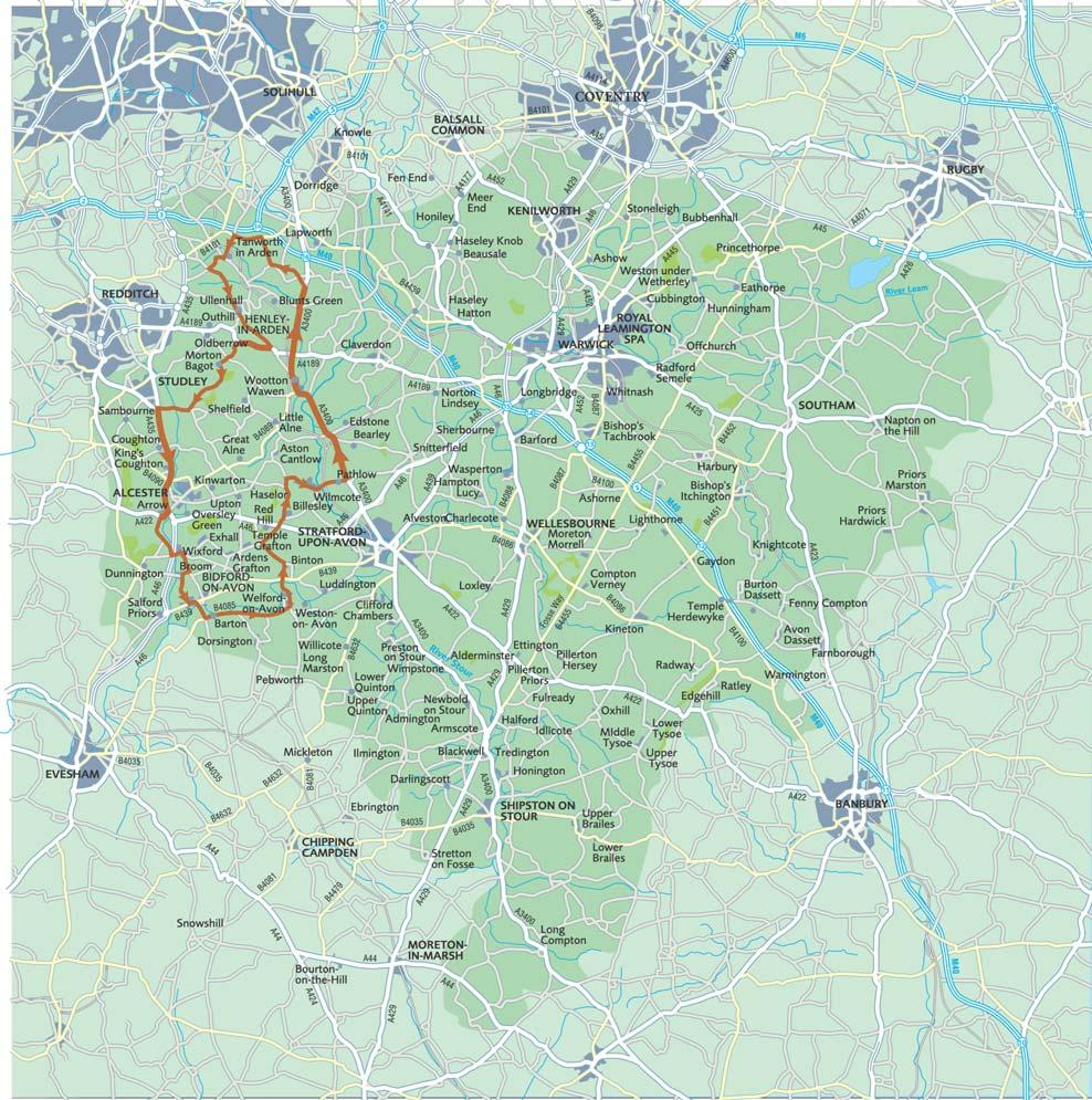
1 SHAKESPEARE COUNTRY LEISURE DRIVES THE ARDEN TOUR (Driving directions are shown in red text) Tour details Approximately 43 miles The Arden was the name once given to the land north of the River Avon. In Shakespeare s time much of this countryside was covered in the Forest of Arden and this is where, in As You Like It, Shakespeare s Rosalind tutored Orlando in the ways of love. The tour passes through some of South Warwickshire s prettiest villages This tour starts from the roundabout with the Globe sculpture in Alcester. Follow signs to Arrow and Ragley Hall. Alcester began as a Roman camp where Ryknild Street crossed the River Alne. It is now one of the most thoroughly investigated small Roman towns in the country. Visit Roman Alcester (1) to experience small town life in Roman times. The fine church tower of St Nicholas dates from the 14th century. It has monuments to the Marquess of Hertford of Ragley Hall and Sir Fulke Greville, restorer of Warwick Castle. At the next roundabout take the second exit signed Wixford. Just after Arrow village, the entrance to Ragley Hall is on the right. Set in 400 acres of parkland, woodland and gardens, Ragley Hall (2) is the family home of the Marquess and Marchioness of Hertford. The Hall contains 18th century furniture, paintings and china, Baroque plasterwork and a stunning 20th century mural. If visiting Ragley Hall, turn left on leaving the estate and, before the road bends sharply round to the left, turn right and pass over a bridge. If not visiting Ragley, before the road bends sharply to the right (clearly signposted), take the left fork and pass over a bridge. Pass the Fish Inn as you enter Wixford. Go over a humpback bridge, then follow the road round to the right (a sharp bend), and go past the Three Horseshoes Pub. Nestling by the River Arrow, just after the Fish Inn, lies a row of pretty half-timbered almshouses built by Sir William Throckmorton of nearby Coughton Court. The village of Wixford s connection with the Roman Catholic Throckmortons is thought to be the reason for Shakespeare calling it papist Wixford. Just after leaving Wixford take the right turn, signed Broom. After a left hand bend keep straight ahead passing a turn on the right for the village centre. Pass Broom Hall Inn on the right, go over the bridge, and enter the outskirts of Bidford-on-Avon. Drive through this quiet village.
2 Shakespeare is said to have taken part in a drinking competition between Stratford and Bidfordon-Avon, having drunk at Piping Pebworth, Dancing Marston, Haunted Hillboro, Hungry Grafton, Dudging Exhall, Papist Wixford, Beggarly Broom and Drunken Bidford. At the T-junction with B439 (opposite a petrol station) turn left. At the next roundabout take the third exit for the village centre and shops. (There is a car park on the left after the roundabout if you wish to explore Bidford on foot). Go straight over at the traffic lights and over a bridge on the River Avon. (Just over the bridge, take a sharp right turn to the recreation ground for picnics and riverside walks). The 15th century bridge in Bidford, with eight arches, is where the Roman Ryknild Street forded the River Avon on its way to Alcester. At the crossroads (on the B4085) turn left to Barton and Welford-on-Avon. Drive into the village of Barton. Look for the unusually named Cottage of Content pub in Barton, next to the appropriately named Letterbox Cottage, on the second bend in the village. After approximately two miles, enter Welford-on-Avon. Welford is an idyllic village with many white washed, half-timbered thatched cottages and a tall maypole on the village green - around which local children still dance on May Day. At the T-junction in the village turn left, passing the village green. Church Street, on the left just before the Bell Inn, is one of the most picturesque roads in Warwickshire. Take care as you pass the Bell Inn on your left (the road narrows to a single lane). As you leave the village, pass the Four Alls pub just before crossing a bridge over the River Avon. If you want to take a diversion, a little further on, in the village of Shottery, stands Anne Hathaway s Cottage (3). Re-trace the steps Shakespeare must have taken when courting, before they were married in Otherwise continue on the tour with the directions. On arrival at the T-junction with the B439 turn right signed Stratford and then immediately left to Binton. At the top of the hill is Binton Church. The Church of St Peter s at Binton has a stained glass window dedicated to Scott of the Antarctic who was married to the sister of the Rector. From the churchyard there are lovely views over the Avon valley. Continue through Binton to the crossroads by the Blue Boar Inn at Temple Grafton. The Blue Boar is a 16th century traditional freehouse and restaurant with bar snacks and local ales. Turn right to Aston Cantlow and Billesley, taking in the view across to Stratford on the right. Take extra care at the staggered crossroads with the busy A46. Cross over (right then left). You will pass Billesley Manor Hotel on your right. Follow the signs for Wilmcote, taking a right turn signed Wilmcote and Mary Arden's House after about two miles. If you want to take a diversion, driving straight on will bring you to Aston Cantlow. The village of Aston Cantlow is grouped around a small green and has some fine old buildings, including the black and white timbered Guild House, where, in the early 16th century, Aston Cantlow s weekly market and fair was held. It is said that William Shakespeare s parents, Mary Arden and John Shakespeare, were married in the Church of St John the Baptist in 1557.
3 To continue with our tour, after turning right for Wilmcote, you will reach the village after about a mile. Turn left just after the Masons Arms, opposite the Mary Arden Inn. Mary Arden s Farm is on your left. Mary Arden s Farm (4) is an early Tudor house which was the childhood home of Shakespeare s mother, Mary Arden. The timbered farmhouse and outbuildings feature many displays about the work and traditions of the countryside around Stratford. There is also a working blacksmith, falconry demonstrations and special events to tie in with the farming calendar. Continue along this road, crossing over the Stratford-upon-Avon canal and railway line, to the T-junction with the A3400. Turn left at the T-junction signed Henley and Wootton Wawen. An optional detour to see the longest aqueduct in England involves going past the turning to Bearley Station and turning left, by the Golden Cross pub, down Salters Lane. Otherwise, follow the A3400 towards Wootton Wawen. Just before the village of Wootton Wawen you pass the Navigation Inn. This was named after the navigators (navvies) who built the canals (the navigation ). A small aqueduct carries the canal over the main road. After passing under the canal bridge Yew Tree Farm Craft Centre (5) is on your right. This traditional old English farmyard houses a farm shop, range of country crafts and a restaurant with good home baking. Drive on past the little church and red brick Old Mill buildings on the right. The A3400 then crosses over the River Alne with its waterfall in front of Wootton Hall on the right. Turn right immediately after the lodge house, at the entrance gates to the hall, to visit the Saxon Sanctuary in St Peter s Church. The Saxon Sanctuary (6) at St Peter s Church is possibly Warwickshire s oldest church and a storybook in stone. A colourful Forest of Arden exhibition, in the barn-roofed Lady Chapel, traces the history of the woodland village. The A3400 bends to the right passing the Old Bull s Head pub and restaurant on the left. The pub is a Grade I Listed building and houses a lovely restaurant where you can stop to have a bite to eat. Look over to your right for views of the church. Continue into Henley-in-Arden. Once you pass over the traffic lights the road becomes the High Street. After passing the church of St. John the Baptist with its offset diamond shaped clock, there is street parking available. If you wish to, park and walk back to the church, passing Guild Hall. Henley-in-Arden originated as a clearing in the Forest of Arden and has a medley of leaning halftimbered buildings containing small shops and a good selection of restaurants, inns and tearooms. The earthworks of the 12th century motte and bailey castle can still be seen next to the Norman Church of St Nicholas. Heritage & Visitor Centre (7) is a part 14th century house containing a history of the town including a model of the Norman castle. Continue out of Henley on the A3400 for around 4 miles, passing the Henley Golf and Country Club on the left. Turn left, signed Earlswood, jsut after Pickles Restaurant on the right and follow a narrow road with passing places. At the crossroads go straight over. Follow the road for about 3 miles, turn left at the next junction, then follow the road to the right signed Earlswood. At the T-junction turn left onto the B4101 (Broad Lane). At the crossroads turn left into Tom Hill. Go under a low bridge and enter the village of Tanworth-in-Arden. Continue to the village centre, past the church and war memorial. At the T-junction, next to the war memorial, turn right. Take the next left signed Ullenhall (Bates Lane). At the crossroads turn left to Ullenhall (Forde Hall Lane). After 1½ miles you will pass Mockley Manor Residential Home. Follow the road round to the right, signed Ullenhall. At the T-junction turn left signed
4 Henley-in-Arden/Wootton Wawen. Go over the speed bumps through the village of Ullenhall. After approximately 2½ miles turn right onto the A4189, signed Redditch. At Oldberrow Church, turn left signed Morton Bagot. At the crossroads go straight over, passing Church Farm on your left. At the T-junction turn right, signed Studley, following the road for just over a mile. At the next T-junction turn left onto the A435 to Alcester. As you enter the village of Coughton, Coughton Court is on your left. Coughton Court (9), home of the Throckmorton family since 1409, has a fine Tudor gatehouse with half timbered courtyard. The House contains an excellent collection of family portraits and memorabilia while the grounds include a lake, riverside walks and, unusually, two churches. The walled garden is a splendid example of garden rooms set with their own particular plant themes. At the next roundabout take the second exit for Alcester town centre. Pass the Roebuck Inn on your left. (At the traffic lights turn left down School Road and follow signs to a car park if stopping to explore the town). To return to the starting point go straight ahead at these lights, and you will return to the roundabout with the Globe sculpture.
5
Approximate distance: 10 miles For this walk we ve included OS grid references should you wish to use them. Start. End
 Approximate distance: 10 miles For this walk we ve included OS grid references should you wish to use them. 2 3 Start End 1 N W E S Reproduced by permission of Ordnance Survey on behalf of HMSO. Crown
ALCESTER POLICE SOUTH AND NORTH JOINT WEEKLY REPORT Sunday 17 th September 2017
 ALCESTER POLICE SOUTH AND NORTH JOINT WEEKLY REPORT Sunday 17 th September 2017 Alcester Police South SNT. Latest Update. Sunday 17th September 2017 ALCESTER *Suspicious Circumstances. Roman Way, Alcester.
The Hundred Parishes
 The Hundred Parishes Walks from railway stations number 9 6.4 miles (10kms) from Bishop s Stortford to Stansted Mountfitchet Start: Bishop s Stortford station (Grid Reference TL492209) (ample parking and
Harlington - Sharpenhoe - Pulloxhill
 Harlington - Sharpenhoe - Pulloxhill ID: 3676, Distance: 8 miles, Height gain: 140 Metres, Map: Explorer 193 Luton & Stevenage, Contributor: Dennis Jeanes Duration: 3 Hours 27 Mins Features Church,Great
Danbury Words and pictures by Laurie Page of the Public Rights of Way team at Essex County Council.
 Danbury Words and pictures by Laurie Page of the Public Rights of Way team at Essex County Council. An undulating walk from Danbury village to the bluebells at the National Trust property of Blakes Wood.
Walk Description. Directions
 Title: Saffron Trail: Battlesbridge to Chelmsford Distance: 14¾ miles Time taken: 6 hours Start Point: Outside the Barge Inn, Battlesbridge OS Explorer Map: 175 & 183 Grid Ref.: TQ 780 947 Transport: Rail:-
RANS WOOD WALK circa 3 miles/ 5 kilometres
 RANS WOOD EXCURSION This walk is about an hour. It is rarely frequented by tourists or by visitors to the National Park. It is a secret favourite amongst local dog walkers and cyclists. The walk is in
Avon Ring from Stratford upon Avon
 UK Canal Boating UK Canal Boating Escape with a canal boating holiday! Telephone : 01395 443545 Email : bookings@ukcanalboating.com Booking Office : PO Box 57, Budleigh Salterton. Devon. EX9 7ZN. England.
For more information and to buy this book click here ISBN: CICERONE. Guides for walkers, trekkers, mountaineers, climbers and cyclists
 For more information and to buy this book click here ISBN: 9781852845377 CICERONE Guides for walkers, trekkers, mountaineers, climbers and cyclists www.cicerone.co.uk WALK 5 Ouston and Urpeth Distance
River and Canal Maps
 River and Canal Maps for Trent Adventure Trent Adventure Base at Poplars Farm Twyford Road Twyford Barrow or Trent DE73 7HJ 07876 751 599 28-Apr-2015 2015 Trent Adventure - Version 3p4 1 Trent and Mersey
How to get there. Respect - Protect - Enjoy
 How to get there Driving: Postcode is RG9 3DG and there is a carpark just across from the pub. Nearest station: Henley-on-Thames station is 5.6 miles away. We re delighted to present three circular walks
Lincolnshire Limewoods Walks. Woodhall Spa. A circular walk of 13km (8 miles)
") Lincolnshire Limewoods Walks Woodhall Spa A circular walk of 13km (8 miles) Introduction The Lincolnshire Limewoods is an area between Wragby, Bardney and Woodhall Spa. It is a fantastic place to explore
Lincolnshire Limewoods Walks Woodhall Spa A circular walk of 13km (8 miles) Introduction The Lincolnshire Limewoods is an area between Wragby, Bardney and Woodhall Spa. It is a fantastic place to explore
Oldbury & Littleton, South Gloucestershire
 Oldbury & Littleton, South Gloucestershire Starts at Church Lane, Oldbury. BS35 1QF 2 hours 0 minutes 5.2miles 8.4km Easy ID: 0.2468 Developed by: GEOFF MULLETT Checked by: Marion Stone www.ramblersroutes.org
Lincolnshire Walks. Grainthorpe. Three circular walks of 2 ¾, 9 and 9 ½ km (1 ¾, 5 ½ and 6 miles)
") Lincolnshire Walks Grainthorpe Three circular walks of ¾, 9 and 9 ½ km (1 ¾, ½ and 6 miles) Introduction Explore the coastal marshes, arable hinterland, Louth Navigation canal and the village of Grainthorpe
Lincolnshire Walks Grainthorpe Three circular walks of ¾, 9 and 9 ½ km (1 ¾, ½ and 6 miles) Introduction Explore the coastal marshes, arable hinterland, Louth Navigation canal and the village of Grainthorpe
9.5 km Circular 3 hours
 RANMORE CIRCULAR A 6 mile (9.5km) circular walk from Boxhill and Westhumble Station in the village of Westhumble, passing through part of the Polesden Lacey Estate, Ranmore Common and Denbies Vineyard.
The Mendip Way. Route Directions and Maps Wells to Frome
 The Mendip Way Route Directions and Maps Wells to Frome Website: www.mendiphillsaonb.org.uk Email: mendip@mendiphillsaonb.org.uk Facebook & Twitter: @MendipHillsAONB Phone: 01761462338 1 Wells to Shepton
Countryside Walks. 1) Highclere Park Public Walk.
 Highclere Park Public Walk.") 1) Highclere Park Public Walk. Access: From Highclere Estate Main Entrance at Whitway, please note there is no parking on site or access for vehicles. Open: Throughout the year. Description: This footpath
1) Highclere Park Public Walk. Access: From Highclere Estate Main Entrance at Whitway, please note there is no parking on site or access for vehicles. Open: Throughout the year. Description: This footpath
This walk description is from happyhiker.co.uk
 This walk description is from happyhiker.co.uk Pendle Hill Walk From Barley Starting point and OS Grid reference Ordnance Survey map Distance Traffic light rating Barley village honesty box car park OS
East Lulworth Ride Route 5
 East Lulworth Ride Route 5 Out of ar Experience - ycling in Purbeck ircular route from Wareham to Lulworth - 18 miles + Lulworth ove oombe Keynes River Frome Time needed: 3-4 hours + Grading: Moderate
How to get there. Respect - Protect - Enjoy
 How to get there Driving: Postcode is OX10 6AD with a car park for customers. Nearest station: Goring & Streatley station is 5.6 miles away. We re delighted to present three circular walks all starting
Effingham to Westhumble
 Main walk morning last checked Main walk afternoon last checked Pub diversion last checked Westhumble Circular last checked 12 December 2017 23 December 2017 19 August 2015 27 October 2017 Document last
10 Miles Circular 5 hours
 VISIT RYEDALE PICKERING AND CAWTHORN CAMPS 10 Miles Circular 5 hours Moderate Terrain 120616 A 10 mile (16km) there and back walk from the market town of Pickering in Ryedale. The route heads north through
How to find us Woolton Hill Argyle FC.
 How to find us Woolton Hill Argyle FC. U7 U12 - Woolton Hill Junior School, Woolton Hill, Newbury, RG20 9XE. U13 U14 - Burghclere Sports and Social Club, Harts Lane, Burghclere, Newbury, RG20 9JD U15 The
WALKING GROUP 9 th JANUARY 2013
 WALKING GROUP 9 th JANUARY 2013 For our first walk of 2013 we were fortunate to have a dry, sunny day. Val hand Fred had planned a walk around Stratford on hard footpaths as the fields were still very
Walks in Lenham. Three delightful walks in and around Lenham from 30 minutes to 90 minutes with map and photographic guides. l l l ABOUT LENHAM
 Walks in Lenham Three delightful walks in and around Lenham from 0 minutes to 90 minutes with map and photographic guides l l l ABOUT LENHAM The medieval village of Lenham, in the Borough of Maidstone,
Green Man Ultra Route Directions 2018
 Green Man Ultra Route Directions 2018 Start-CP1 (9 miles) Community Forest Path (CFP) Frome Valley Way (FVW) From the starting line cross the playing fields diagonally to the metal gates in the hedge lined
The North Pennines from near Langwathby
 3.6 Langwathby to Armathwaite Map panel?? Distance 12.7 miles (20.5 km) Terrain farm, woodland and riverside paths; some potentially muddy tracks; a few short sections of road Grade gently undulating Food
There are toilets at Manningtree Station, Flatford (close to the hump back bridge) and in Dedham.
 and in Dedham.") Arriving by Train Main Features of the Walk Outline Route Employs particularly attractive paths, many of which offer impressive views across Dedham Vale. Includes a section along the tidal section of the
Arriving by Train Main Features of the Walk Outline Route Employs particularly attractive paths, many of which offer impressive views across Dedham Vale. Includes a section along the tidal section of the
Atherstone and return from Rugby
 UK Canal Boating UK Canal Boating Escape with a canal boating holiday! Telephone : 01395 443545 Email : contact@ukcanalboating.com Booking Office : PO Box 57, Budleigh Salterton. Devon. EX9 7ZN. England.
A Walk around Holmes Chapel starting & finishing at Holmes Chapel Railway Station. by Tony & Lindsay Wright (2016)
") A Walk around Holmes Chapel starting & finishing at Holmes Chapel Railway Station. by Tony & Lindsay Wright (2016) Introduction Holmes Chapel Railway Station is on the Crewe to Manchester line. The station
A Walk around Holmes Chapel starting & finishing at Holmes Chapel Railway Station. by Tony & Lindsay Wright (2016) Introduction Holmes Chapel Railway Station is on the Crewe to Manchester line. The station
Avon Ring from Stourport on Severn
 UK Canal Boating UK Canal Boating Escape with a canal boating holiday! Telephone : 01395 443545 Email : contact@ukcanalboating.com Booking Office : PO Box 57, Budleigh Salterton. Devon. EX9 7ZN. England.
Fertile farms in the heart of Kent
 55 55 Fertile farms in the heart of Kent A bright sunny day is perfect for enjoying the rich and fertile Kent countryside and outstanding views across the valley of the Great Stour to the North Downs.
BALCOMBE AND ARDINGLY RESERVOIR, WEST SUSSEX
 BALCOMBE AND ARDINGLY RESERVOIR, WEST SUSSEX 7 miles Circular 4 hours 080816 Challenging Terrain Hi, I'm Luke and this is my West Sussex Weekends walk It's a 7 mile loop from Balcombe rail station, taking
A circular walk of or km (2 1 4 or miles)
") Grantham A circular walk of 3 3 4 or 5 3 4 km (2 1 4 or 3 1 2 miles) Introduction This relatively short circular walk, which starts in the middle of Grantham, offers plenty of variety. The route takes
Grantham A circular walk of 3 3 4 or 5 3 4 km (2 1 4 or 3 1 2 miles) Introduction This relatively short circular walk, which starts in the middle of Grantham, offers plenty of variety. The route takes
Husthwaite to Byland Abbey
 Husthwaite to Byland Abbey This walk begins with a loop round the village of Husthwaite and continues towards Coxwold along a disused railway line, which is now a right of way. It passes through Coxwold
Beautiful Walks from the Blue Ball Inn
 Walk No. 7 COAST AND VALLEY WALK Countisbury, Glenthorne, County Gate, Brendon, Rockford and Wilsham 10 MILES APPROX. Walking time 5 hours approx. (not including breaks)> OS Sheet 64/74 Lynton and Lynmouth.
9.5 km Circular 3 hours
 MEDIEVAL WAVERLEY Challenging Terrain A 6 mile (9.5km) undulating circular walk from Tilford village passing close to The Sands village and the historic ruins of Waverley Abbey. From the top of Crooksbury
Hammer Vale and Linchmere Common
 point your feet on a new path Hammer Vale and Linchmere Common Distance: 9 km=5½ miles or 6 km=3¾ miles easy walking with one steep section Region: Hampshire, West Sussex Author: Botafuego Refreshments:
Hascombe and Winkworth Arboretum Downs Link Path, Smithbrook Kilns
 point your feet on a new path Hascombe and Winkworth Arboretum Downs Link Path, Smithbrook Kilns Distance: 18 km=11 miles Region: Surrey Author: RDC easy walking Date written: 7-may-2016 Last update: 30-aug-2018
CHILTERN RAMBLING TRAIL
 CHILTERN RAMBLING TRAIL This route, including a section of the Ridgeway Long Distance Path, offers breathtaking views from the Chiltern ridge. It starts in the Ashridge Estate and returns to Tring via
Bakewell Club Site - Robin Hood's Stride
 Bakewell Club Site - Robin Hood's Stride Camping and Caravanning Route Summary A circular walk with fabulous views winding it's way through the beautiful White Peak scenery. Points of interest include
ALCESTER POLICE SOUTH AND NORTH JOINT WEEKLY REPORT Sunday 24 th September Alcester Police South SNT. Latest Update. Sunday 24th September 2017
 ALCESTER POLICE SOUTH AND NORTH JOINT WEEKLY REPORT Sunday 24 th September 2017 Alcester Police South SNT. Latest Update. Sunday 24th September 2017 ALCESTER *Damage. St Faiths Road, Alcester. Scratch
NETTLESTEAD & YALDING
 NETTLESTEAD & YALDING ULL CIRCUIT - Sheet 1 (first and last sections) Open fields (see 'Introductory Notes') 88 Direction label (as in the walk notes) ROADS: 81 10m Significant roads Redhill arm North
Lloyds Banking Group Lean On Me Challenge 2017
 Lloyds Banking Group Lean On Me Challenge 2017 Mapbook West Country Walk September 21 In aid of Mental Health UK Join the Facebook Group Lean On Me Challenge for updates on the event Or follow on Twitter
THE WELLDIGGERS ARMS, HESWORTH AND FITTLEWORTH TRAIL
 THE WELLDIGGERS ARMS, HESWORTH AND FITTLEWORTH TRAIL 5.5 miles Circular 3 hours 041017 Challenging Terrain A 300-year-old pub turned country-inn on the edge of the South Downs National Park, The Welldiggers
Lincolnshire Walks. Ancaster. Three cir cular walks of2 3/4,4or 6km (11/3, 21/2 or 33/4 miles)
") Lincolnshire Walks Ancaster Three cir cular walks of2 3/4,4or 6km (11/3, 21/2 or 33/4 miles) Introduction These walks are set in the attractive countryside around the historic town of Ancaster. The town
Lincolnshire Walks Ancaster Three cir cular walks of2 3/4,4or 6km (11/3, 21/2 or 33/4 miles) Introduction These walks are set in the attractive countryside around the historic town of Ancaster. The town
Slindon Folly - South Downs, West Sussex
 Slindon Folly - South Downs, West Sussex Starts at Park road-side near entrance to Slindon College 2 hours 15 minutes 4.5miles 7.2km Easy ID: 0.1598 Developed by: Chris Mumford Checked by: Rockpit www.ramblersroutes.org
Redesdale Arms. A Trio of Walks
 Redesdale Arms A Trio of Walks Welcome to The Redesdale Arms Hotel The award winning 34 bedroom Redesdale Arms Hotel sits at the gateway to the Cotswolds in the High Street of the historic town of Moreton-in-Marsh.
Views! village, woodland, hills, high trails, fine houses, hidden church
 point your feet on a new path Heath Distance: 9½ km=6 miles Region: Chilterns Author: Phegophilos Refreshments: easy walking Date written: 13-oct-2017 Map: Explorer 171 (Chiltern Hills West) but this guide
Aston Village: The Flowerpot (pub walk)
") point your feet on a new path Aston Village: The Flowerpot (pub walk) Distance: 10 km=6¼ miles or 8 km=5 miles (omitting the weir) Region: Berkshire, Chilterns Author: MacMeadow Refreshments: Henley, Aston
point your feet on a new path Aston Village: The Flowerpot (pub walk) Distance: 10 km=6¼ miles or 8 km=5 miles (omitting the weir) Region: Berkshire, Chilterns Author: MacMeadow Refreshments: Henley, Aston
Outwood: oaks, buttercups and windmill
 point your feet on a new path Outwood: oaks, buttercups and windmill Distance: 9 km=5½ miles Region: Surrey Author: Schwebefuss Refreshments: Outwood easy walking Date written: 23-may-2014 Last update:
For Your Own Safety. Please make a note below of the contact number that should be used in the event that you get lost or require other assistance
 Respect Protect Enjoy Respect other people Consider the local community and other people enjoying the outdoors Leave gates and property as you find them and follow paths unless wider access is available
Gainsborough and Fledborough Circular
 Trent Vale Cycle Route TVCR18 Gainsborough and Fledborough Circular Gainsborough Old Hall. One of the biggest and best preserved Medieval Manor Houses in England. Start Point: Gainsborough Marshall s Yard
Bonnie Prince Charlie Walk
 Bonnie Prince Charlie Walk A waymarked route from Ashbourne to Derby to celebrate the 60th anniversary (1995) of the formation of the Ramblers' Association. This route follows the general direction of
Saltash, Cornwall - Railways, Rivers & Castles
 Saltash, Cornwall - Railways, Rivers & Castles Starts at St Stephen's Church, Saltash, Cornwall 2 hours 45 minutes 5.5miles 8.9km Easy ID: 0.2532 Developed by: Peter Clements Checked by: Kevin Connor www.ramblersroutes.org
Horsted Keynes to Sheffield Park Hop On The Bluebell Line
 point your feet on a new path to Sheffield Park Hop On The Bluebell Line Distance 11½ km=7 miles Region: West Sussex, East Sussex Author: Hautboy easy walking with a steam train ride Refreshments: The
Walk 2: Beamsley Beacon and Bolton Abbey
 Walk 2: Beamsley Beacon and Bolton Abbey Start and Finish: The Memorial Hall, Main Street, Addingham, LS29 0LZ, SE 079 497 The shortest walk is about 5½ miles (8.8km) The medium Walk is about 8¼ miles
LOCAL CIRCUIT EM1: EAST MALLING & BARMING HEATH. N 2m ROADS: Significant roads PATHS: Starting direction Barming Longsole Mission Church
 Ditton Church Scott Close LOCAL CIRCUIT EM1: EAST MALLING & BARMING HEATH 6 Community Centre F Open fields (see 'Introductory Notes') 1m 88 Direction label (as in the walk notes) East Malling Church -
Bradenham and West Wycombe
 point your feet on a new path Bradenham and West Wycombe Distance: 9 km=5½ miles + very short options Region: Chilterns Author: Bryntafion easy walking Date written: 18-jan-2012 Date revised: 23-aug-2015
Key Information. Self-Guided Walk Exploring Sedbergh
 Self-Guided Walk Exploring Sedbergh A great short walk - ideal for an early evening in summer. This is a lovely circuit of Sedbergh visiting some of the historic buildings as well as ambling by the river
How to get there. Respect - Protect - Enjoy
 How to get there Driving: Postcode is RG9 6QU and there is a car park for customers. Nearest station: Marlow train station is 7.8 miles away. We re delighted to present three circular walks all starting
Walking without Walls. Slow Marathon: Dufftown to Huntly
 Walking without Walls Slow Marathon: Dufftown to Huntly Walking without Walls Slow Marathon: Dufftown to Huntly www.deveron-projects.com Deveron Projects The Studio, Brander Building, Huntly, AB54 8BR,
Walk 7: Watchet to washford
 Walk 7: Watchet to washford Length: Moderate - 7.5 miles / 12 km Good For: Theme: History Duration: 2-3 hours depending on speed of walking Notes: This is a moderate to difficult walk in places, with steps,
Thornton le Dale Walks
 Thornton le Dale Walks A collection of circular walks in, and around, the village www.visitthorntonledale.co.uk Thornton-le-Dale Traders Forum and Thornton le Dale Parish Council 1 Thornton le Dale Circular
10 km Circular 3 hours
 FRIMLEY AND FRIMLEY GREEN 10 km Circular 3 hours Easy Terrain 250716 A 10km (6 mile) circular walk exploring the canal towpath, riverside path, woodland, heath and small settlements around Frimley in Surrey.
Tinneyhall Wood, Cornwall - About 9 ½ acres, 59,000
 Tinneyhall Wood, Cornwall - About 9 ½ acres, 59,000 Tinney Hall is a hamlet close by the small hilltop village of Lewannick, which is centred around a crossroads. This is unusual for Cornwall, where the
TOCKENHAM. Walks for Healthy Living. The Countryside Code (October 2016) Respect other people:
 Respect other people:") The Countryside Code (October 2016) TOCKENHAM Respect other people: consider the local community and other people enjoying the outdoors leave gates and property as you find them and follow paths unless
The Countryside Code (October 2016) TOCKENHAM Respect other people: consider the local community and other people enjoying the outdoors leave gates and property as you find them and follow paths unless
Welsh Newton and Woodland
 Welsh Newton and Woodland This is a 8.2km miles (approx) walk which will take about 2.5 hours at a relaxed and leisurely pace. There are a few hills but no steep inclines. Start at Llangrove bus stop and
Although the majority of these walks are around country lanes you should still follow the Country Code:-
 With the update of the Parish Plan was a request for details of any Walks around Pillaton The following pages give several walks that I and my wife have done for many years. Please be aware that NONE OF
DUNS TEW GRANGE DUNS TEW OXFORDSHIRE
 DUNS TEW GRANGE DUNS TEW OXFORDSHIRE DUNS TEW GRANGE DUNS TEW OXFORDSHIRE A substantial farmhouse with outdoor heated swimming pool, range of stabling/outbuildings and gardens and grounds of approximately
Walk 2: doniford to east quantoxhead
 Walk 2: doniford to east quantoxhead Length: 9 ¼ miles / 15km Good For: Difficulty: Moderate Theme: Nature Notes: This walk is tidal - please check tide times before setting off. Dogs are welcome but need
The main feature of this tranquil walk is a visit to the source of the Thames (the Thames head) which is in a field just 3 km from Kemble station
 which is in a field just 3 km from Kemble station") SWC Walk DRAFT Kemble circular: the source of the River Thames. The main feature of this tranquil walk is a visit to the source of the Thames (the Thames head) which is in a field just 3 km from Kemble
SWC Walk DRAFT Kemble circular: the source of the River Thames. The main feature of this tranquil walk is a visit to the source of the Thames (the Thames head) which is in a field just 3 km from Kemble
No. 1 By River Ribble & Brungerley Park 3¼ Miles,
 RVRNEWS 102 No. 1 By River Ribble & Brungerley Park 3¼ Miles, Approx 2 Hours This walk starts at the gate on platform 2 of Clitheroe station. Leaving the station turn left making towards Kirkmoor Rd and
Shepherdswell - Dover
 Shepherdswell - Dover The North Downs Way > Shepherdswell to Dover Introduction This part of the path is slightly different in character from most other parts of the path since it spends much of the time
Great Chesterford to Newport (Essex) walk
 walk") Saturday Walkers Club www.walkingclub.org.uk Great Chesterford to Newport (Essex) walk Through rolling hills and river valleys to the historic market town of Saffron Walden and one of Britain's finest
Saturday Walkers Club www.walkingclub.org.uk Great Chesterford to Newport (Essex) walk Through rolling hills and river valleys to the historic market town of Saffron Walden and one of Britain's finest
Ovington and Itchen Stoke
 Trail Activity Type Terrain Author Distance Ascent Location : HAMPTR0057 : Walk : Pub : Towpaths and Cycle Tracks : Peter Carne : 1.4 miles / 2.2 kms : 62 feet / 19 metres : SU560318 / SO24 0RE Bush Inn,
Greenwood. Walks. Cossall Canal Walk. Cossall Canal Walk
 Cossall Canal Walk C5 Cossall Canal Walk C5 Features: Cossall is a picturesque, relatively unspoiled village on the Nottingham canal, four miles south-east of Eastwood. Architecturally interesting. See
How to get there. Respect - Protect - Enjoy
 How to get there Driving: Postcode is OX49 5HL with a car park for customers Nearest station: Henley on Thames station is 9.5 miles away. We re delighted to present three circular walks all starting and
Angel Drove carpark 3/day
 GETTING TO ELY ( A on the map below marks the city centre; for a larger scale see the map at the end of the directions, where there are also details of car parking and pedestrian access to the venue) Angel
Weatherman Walking. Approximate distance: 5.5 miles For this walk we ve included OS grid references should you wish to use them. Start.
 Approximate distance: 5.5 miles For this walk we ve included OS grid references should you wish to use them. 4 1 Start End 3 2 N W E S Reproduced by permission of Ordnance Survey on behalf of HMSO. Crown
CHINTHURST HILL AND THE GRANTLEY ARMS, SURREY
 CHINTHURST HILL AND THE GRANTLEY ARMS, SURREY 4 miles Circular 2 hours 110417 Challenging Terrain A 4 mile (can be shortened to 3 miles) circular pub walk near Wonersh in Surrey. The walk begins with an
Stokenchurch. Bluebell Woods, Bomber Memorial, Red Kites, Getty s Cricket Ground, Nature Reserve
 Stokenchurch Bluebell Woods, Bomber Memorial, Red Kites, Getty s Cricket Ground, Nature Reserve Bomber Memorial The best time to visit Cowleaze Wood is in the spring when there is a memorable display of
Approximate distance: 5.5 miles For this walk we ve included OS grid references should you wish to use them. Start. End
 Approximate distance: 5.5 miles For this walk we ve included OS grid references should you wish to use them. End 4 1 Start 3 2 N W E S Reproduced by permission of Ordnance Survey on behalf of HMSO. Crown
6 Miles Linear 3 hours
 6 Miles Linear 3 hours SUSSEX HOSPICES TRAIL PART 2: BARNHAM TO ARUNDEL Moderate Terrain 131016 A 6 mile linear walk from Barnham rail station to Arundel rail station in West Sussex, forming the second
Sandilands to Huttoft Bank
 Coastal Country Park Walks Sandilands to Huttoft Bank A CIRCULAR WALK OF 11KM (7 MILES) INTRODUCTION The Lincolnshire Coastal Country Park lies between Sandilands, Chapel St Leonards and Huttoft on the
Stage 5 Overview. 5 miles: Out of cricket club, follow path under A413 (by stream MIND YOUR HEAD!), and onto Old Amersham Rd
, and onto Old Amersham Rd") Stage 5 Overview Start time: 12:53 Saturday Distance: 13.5 miles Emergency: 07966 542315 Start: From Common Road, left to path then join Cockpit Road, then over BUSY ROAD to Heath End Road. 2 miles: off
Stage 5 Overview Start time: 12:53 Saturday Distance: 13.5 miles Emergency: 07966 542315 Start: From Common Road, left to path then join Cockpit Road, then over BUSY ROAD to Heath End Road. 2 miles: off
Banstead: Village and Woods
 point your feet on a new path : Village and s Distance: 10 km=6 miles Region: Surrey Author: Fusszweig Refreshments:, The Ramblers Rest easy walking Date written: 2-apr-2014 Last update: 11-apr-2017 Map:
Weatherman Walking Sully to Penarth Approximate distance: 5 miles End Start
 Approximate distance: 5 miles For this walk we ve included OS grid references should you wish to use them. 4 End Start 2 3 N W E 1 S Reproduced by permission of Ordnance Survey on behalf of HMSO. Crown
A mainly flat walk along the Peak Forest Canal to Castle Hill and returning along the River Tame via Hulmes Wood and Haughton Dale.
 Walk 9 Haughton Green, Peak Forest Canal, Castle Hill, Hulmes Wood, River Tame, Haughton Dale Circular Miles: 3.9 Time: 1 Hour 30 Minutes Grade: Easy To Moderate Starting Point: Junction Of Gibraltar Lane/Newport
RILLINGTON TO MALTON by Tania Dickinson
 RILLINGTON TO MALTON by Tania Dickinson This walk takes you from the Vale of Pickering up on to the Wold scarp, before dropping down again through the pretty village of Settrington and joining the Centenary
SUMMER WALK 10. The Chairmakers, Worlds End
 SUMMER WALK 10 The Chairmakers, Worlds End Tuesday 10 th June 7.30pm This is a very short walk made so due to the majority of the footpaths in the area around the Chairmakers being overrun with high nettles
Circular route from Wareham to Moreton - 22 miles
 Lawrence Ride Route 4 Out of ar Experience - ycling in Purbeck ircular route from Wareham to Moreton - 22 miles ottages at Throop hurch at Moreton Ford at Turnerspuddle Time needed: 4-5 hours Grading:
THE DOG AND DUCK HAREWOODS ESTATE TRAIL. 6 Miles Circular 3 hours. Getting there. Walk Sections
 THE DOG AND DUCK HAREWOODS ESTATE TRAIL Moderate Terrain A 6 mile circular pub walk from the Dog and Duck in Outwood, Surrey. The Dog and Duck is a delightful pub where everyone is made welcome. From walkers
How to get there. Respect - Protect - Enjoy
 How to get there Driving: Postcode is RG9 5PF and there is a car park just across from the pub. Nearest station: Henley-on-Thames station is 5.6 miles away. We re delighted to present three circular walks
LDWA SOUTH DOWNS MARATHON
 AHD ahead SDW South Downs Way BL/BR bear left/bear right TL/TR turn left/turn right SP signpost/fingerpost X cross LEG 1 - EAST DEAN to WP1 NORTON GR 470019. Open 1030 to 1300. 9.6 miles. 1.1 From village
NEWLANDS CORNER AND ST MARTHAS
 NEWLANDS CORNER AND ST MARTHAS 10k CIRCULAR ROUTE 2½-3HRS GU4 8SE From Newlands Corner on the North Downs just outside Guildford, you can enjoy one of the most beautiful panoramas of quintessential English
Blackheath and Shamley Green
 point your feet on a new path and Shamley Green Distance: 14 km=9 miles Region: Surrey Author: Schwebefuss Refreshments:, Shamley Green easy walking with one climb Date written: 27-jun-2009 Date revised:
Walk Description. Directions
 Title: East Hanningfield Distance: 8 miles / 9 miles Time taken: 3-3½ hours Location: 5 miles south east of Chelmsford Parking: Free car park off The Tye, East Hanningfield, next to the primary school
Uif!Cmbdl!Kvh!bne! Wbsnibn!Qbsl-!Ipstibn-! Wftu!Tvttfy
 Uif!Cmbdl!Kvh!bne! Wbsnibn!Qbsl-!Ipstibn-! Wftu!Tvttfy 7/6!njmft! Djsdvmbs!!!! 3/6!up!4! ipvst 200114 Moderate Terrain Uif!Cmbdl!Kvh!jt!b!hsfbu!upxn!qvc!dfnusfe! bspvne!b!mbshf!cbs!xjui!xppefn!qbnfmmjnh-!
West Marden and Stansted Forest
 point your feet on a new path West Marden and Forest Distance: 3½ km=8½ miles easy walking with optional ½ km=½ miles extension to Rowlands Region: West Sussex Author: Hautboy Refreshments: West Marden,