Up side crossing approach
|
|
|
- Dina Wright
- 5 years ago
- Views:
Transcription
1


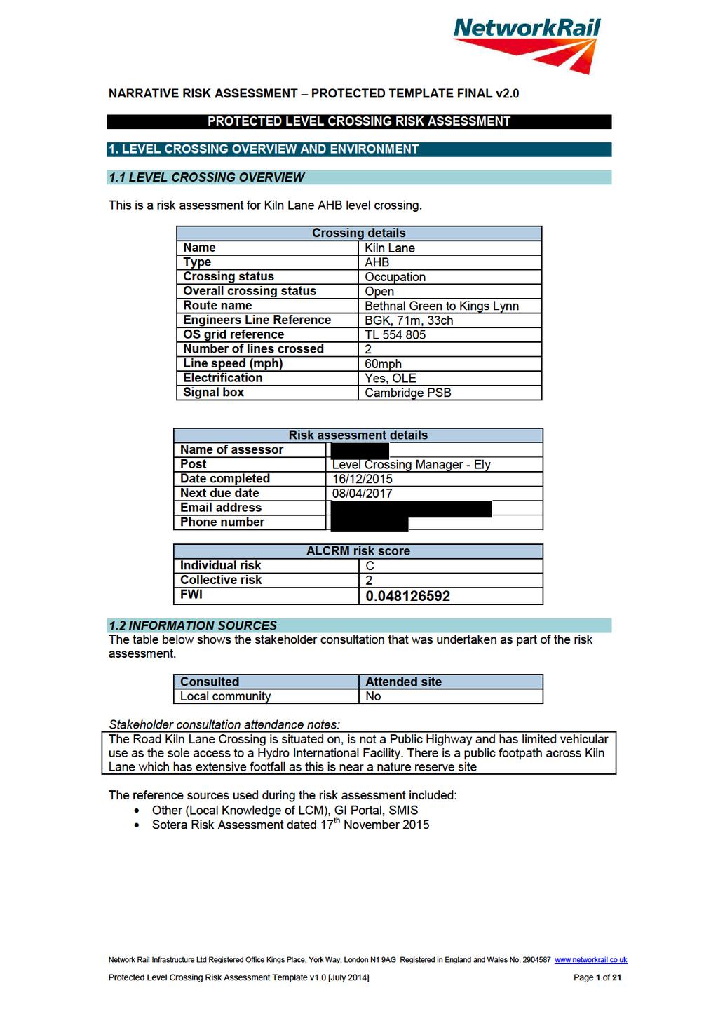
2 1.3 ENVIRONMENT Up side crossing approach Down side crossing approach The level crossing is located on Kiln Lane which is unusually an occupation use AHB due to being the sole access to a Hydro International Facility. The road approach speed is estimated to be less than or equal to 30mph. There are no stations visible at the level crossing. Protected Level Crossing Risk Assessment Template v1.0 [July 2014] Page 2 of 21
3 At Kiln Lane AHB the orientation of the road/path from the north is 110 ; the orientation of the railway from the north to the up line in the up direction is 240. Low horizon can result in sun glare; sun glare is a known potential issue at this crossing. There are no planned or apparent developments near the crossing which may lead to a change or increase in use or risk. Site visit general observations: There are marked footways over the crossing but users tend to walk down the middle of the road as vehicle use is low and the speed vehicles will travel over the crossing is low. The vegetation on the Up and Down Approaches to the crossing requires constant monitoring by the LCM as if left to grow it impinges on the sighting of the crossing and all the signage. The LCM is in constant contact with the environment agency to ensure this is managed correctly. Following liaison with the Environment Agency, signage which had previously been obscured by vegetation on the up side is now in a much better condition. The vegetation has been cut back and the LCM constantly monitors this on the 7 weekly inspections. As at time of this Assessment there have been no further incidents with vegetation obscuring visibility of signs at this crossing. Keep Dogs On Leads Signs have been added to this crossing recently 2. LEVEL CROSSING USAGE 2.1 RAIL The train service over Kiln Lane AHB level crossing consists of passenger and freight trains. There are 258 trains per day. The highest permissible line speed of trains is 60mph. Trains are timetabled to run for 24 hours per day. Assessor s train service notes: There is a high frequency of trains and a high frequency of pedestrian usage at this crossing, mixed in with a relatively low frequency of vehicular usage. The train service is expected to increase in the next year or two years and this will therefore increase the risks associated with the crossing assuming this service increase actually happens. 2.2 USER CENSUS DATA A 24 hour census was carried out on 12/06/2013 by Count On Us Survey A further 9 day survey was undertaken by Sotera from to The data below is a combination of both census results. These two results apply to 100% of the year. The census taken on the day is as follows: Cars 125 Vans / small lorries 42 Buses 1 HGVs 17 Pedal / motor cyclists 28 Pedestrians 300 Tractors / farm vehicles 1 Horses / riders 0 Animals on the hoof 0 Available information indicates that the crossing has a high proportion of vulnerable users. Protected Level Crossing Risk Assessment Template v1.0 [July 2014] Page 3 of 21
4 Vulnerable user observations: LCM has observed elderly ramblers using this crossing at previous asset inspections, and also has seen school children using this crossing signaller confirmed by telephone that a peak time for potential abuse is the school holidays. LCM has observed joggers with headphones running over the crossing, racing cyclists, and also dog walkers. Available information indicates that the crossing has a high number of irregular users. Irregular user observations: Crossing is located near a marina/lakes, ramblers frequently use the nearby footpaths, is used as a cut through by the general public and tourists when walking dogs/going into Ely Assessor s general census notes: A 24 hour census was carried out on 12/06/2013 by Count On Us Survey A further 9 day survey was undertaken by Sotera from to The data above is a combination of both census results. Both census results confirm that footfall over this crossing is a greater risk in terms of numbers using it, as opposed to vehicle usage. 2.3 USER CENSUS RESULTS ALCRM calculates usage of the crossing to be 170 road vehicles and 249 pedestrians and cyclists per day. 3. RISK OF USE 3.1 CROSSING APPROACHES The road approach speed is estimated to be less than or equal to 30mph. None of the approach roads to Kiln Lane AHB level crossing are assessed as being long and straight. There are prominent features on the approach to or on the far side of the level crossing that could distract drivers. Site visit observations: Very scenic area lakes are clearly visible from the roads, could easily distract drivers The road surface, including gradient if present, is unlikely to impact on the ability of a vehicle to stop behind the stop line. There are no known issues with ice, mud, loose material or flood water. In addition, there are known issues with foliage or fog and bad weather. These known issues might impair visibility of the crossing or crossing equipment, including signage. They might also affect the ability of a vehicle to stop behind the stop line. Assessor s notes: Fog at certain times of year, bad weather can affect general visibility At the estimated road speed, the visibility of level crossing signage and equipment is considered to be sufficient for road users to be able to react in time if the crossing is activated. 3.2 AT THE CROSSING GROUNDING RISK The visual evaluation of the vertical profile of the road indicates that it does create a risk of vehicles grounding on the crossing. Risk of grounding signs have been provided at the crossing. Assessor s notes: Signs are in place profile of crossing is such that LM believes this is a possibility if only a slight one Protected Level Crossing Risk Assessment Template v1.0 [July 2014] Page 4 of 21
5 3.3 AT THE CROSSING BLOCKING BACK The road layout at or close to the crossing does not result in identified incidents of traffic queuing over the crossing. No incidents of blocking back are recorded and there are no identified issues with the road layout, parked cars or other features that could stop traffic. In addition, the road is not a known diversionary route. Neither census recorded any blocking back issues. 3.4 AT THE CROSSING ANOTHER TRAIN COMING RISK Trains are occasionally known to pass each other at this crossing. Assessor s another train coming notes: The high number of trains that pass through this crossing means it is almost inevitable at some point that trains will pass each other. This clearly does happen but has been observed infrequently upon inspections. 3.5 INCIDENT HISTORY A level crossing safety event has been known to occur at Kiln Lane AHB crossing in the last twelve months and incident history since 2010 is outlined below -. Assessor s incident history notes: 16/02/ :10 Finalised 30/05/ :12 Finalised 14/04/ :50 Finalised 08/05/ :40 Finalised 26/06/ :20 Finalised 30/10/ :38 Finalised 04/02/ :19 Finalised 13/12/ :59 Finalised 03/10/ :53 Finalised 20/03/ :20 Finalised Kiln Lane LC Kiln Lane LC Kiln Lane LC Kiln Lane LC Kiln Lane LC Kiln Lane LC Kiln Lane LC Kiln Lane LC Kiln Lane LC Kiln Lane LC Dustbin lorry struck downside road light cluster at Kiln Lane level crossing, causing minor damage Children interfering with Kiln Lane level crossing User failed to call back after crossing Kiln Kane LC 1T25 19:15 Kings Cross - Kings Lynn struck a dog at Kiln Lane LC Trespass Kiln Lane LC - Person in distressed states laying near bowmac panels. LC Misuse - Telephones taken off the hook by youths at Kiln Lane LC. Near miss other- trains cautioned for person threatening suicide line side near Kiln Lane Level Crossing. Level crossing misuse - Low Loader road vehicle did not requested permission to re use Kiln Lane AHB Level Crossing. LC Misuse - Kids placed ballast on the railhead at Kiln lane LC as per 1R98 14:57 Norwich - Liverpool Lime Street. Trespass - 2K68 10:52 Cambridge - Norwich; person trackside chasing dog at Kiln Lane. Protected Level Crossing Risk Assessment Template v1.0 [July 2014] Page 5 of 21
6
7
8
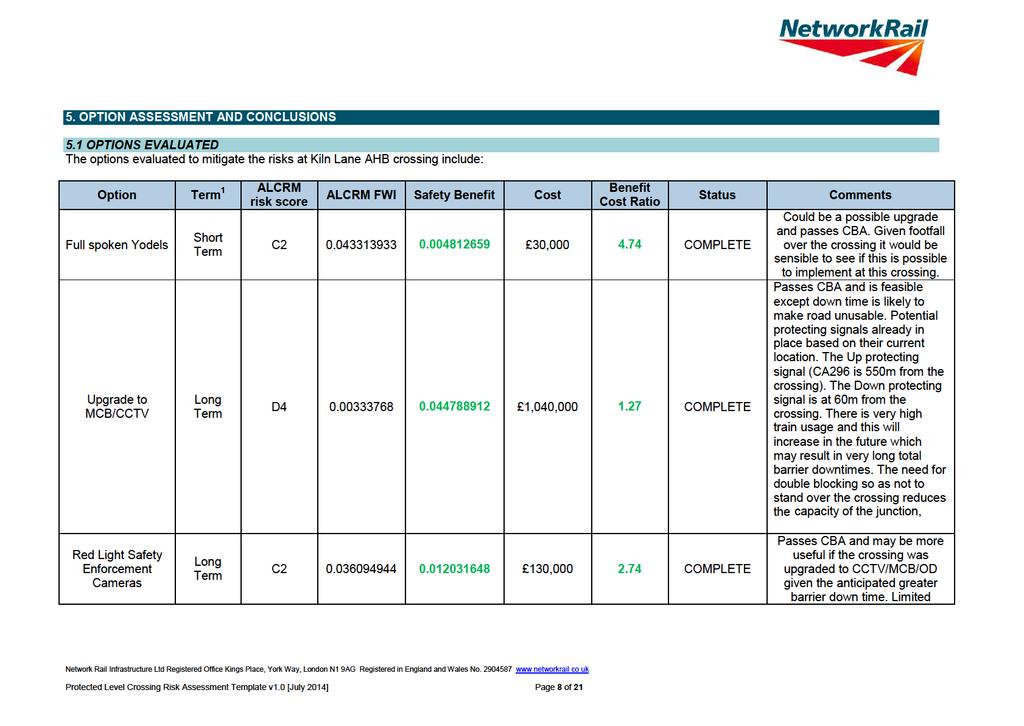
9 Upgrade to MCB/OD Flashing Pedestrian Signs Closure By Bridge or By Pass Long Term Short Term Long Term D ,140, COMPLETE C , COMPLETE M ,000,000 5,000, COMPLETE vehicular access may make this an option which is best considered as part of a package not a singular solution on its own. Only real logical upgrade downtime would be an issue Would be a possible upgrade and passes CBA. Would be a recommended option here given type of pedestrian usage Bridge - High level of pedestrian use Sole means of vehicular access to Hydro International site. Feasible. Area of natural beauty - would have to be in keeping with the local area. Currently on a significant skew but it may be possible to reduce this by remodelling the road. Not a Public Road so it would not have to be highway standard bridge. By Pass -. Alternative access from Queen Adelaide and exiting bridge River Great Ouse at the CEMEX Ely Asphalt and rail depot. Would need to get permission to use bridge/access road at this location and use the CEMEX depot as a through road. At present there is a pedestrian bridge over the waterway between the CEMEX depot and Protected Level Crossing Risk Assessment Template v1.0 [July 2014] Page 9 of 21
10 the Hydro International site. Need to investigate whether there is a legal right for CEMEX to offer a through road to Hydro International site. High level of uncertainty in the estimate but substantial bridge required over waterway between CEMEX and Hydro international. NOTES Network Rail always evaluates the need for short 1 and long term risk control solutions. An example of level crossing risk management might be; a short term risk control of a temporary speed restriction with the long term solution being closure of the level crossing and its replacement with a bridge. 1 Includes interim CBA gives an indication of overall business benefit. It is used to support, not override, structured expert judgement when deciding which option(s) to progress. CBA might not be needed in all cases, e.g. standard maintenance tasks or low cost solutions (less than 5k). The following CBA criteria are used as a support to decision making: a. benefit to cost ratio is 1: positive safety and business benefit established; b. benefit to cost ratio is between 0.99 and 0.5: reasonable safety and business benefit established where costs are not grossly disproportionate against the safety benefit; and c. benefit to cost ratio is between 0.49 and 0.0: weak safety and business benefit established. Protected Level Crossing Risk Assessment Template v1.0 [July 2014] Page 10 of 21

11 5.2 CONCLUSIONS Assessor s notes: Kiln Lane is an AHB crossing with two half width barriers and four Road Traffic Lights (Wig Wags). The crossing is monitored from Cambridge Signal Box. The crossing is located to the east of Ely on Kiln Lane and provides the sole means of vehicular access to a Hydro International facility. The road is understood not to be a public highway although there is a public footpath across the crossing. The line speed over the line is 60 mph. Trains are very frequent with 258 trains per weekday including passenger and freight services. The crossing lies within the Ely Pits and Meadows SSSI as detailed below -. Given that the key risk drivers for this crossing are frequency of trains, pedestrian and cycle usage (including vulnerable and irregular users), low vehicle usage although a remote private road may facilitate misuse by risk takers, a small trespass and vandalism issue and visibility issues the following options should be considered Protected Level Crossing Risk Assessment Template v1.0 [July 2014] Page 11 of 21
12 Recommendations from Sotera Risk Assessment dated 17 th November 2015 CONCLUSIONS AND RECOMMENDATIONS The following conclusions and recommendations are made from the analysis: Closure 1. The crossing provides the sole means of vehicular access to a Hydro International facility. The road is understood not to be a public highway although there is a public footpath across the crossing. It is, therefore, not considered feasible to close without making alternative arrangements. 2. A road bridge at the site of the crossing was thought in 2013 to be feasible with some minor road remodelling in order to reduce the skew of the crossing. It is, however, now understood that it is much more difficult than previously though due to the height requirement. 3. An off-line road bridge close to the site of the crossing may be feasible with some minor road remodelling in order to reduce the skew of the crossing. The crossing is on a Site of Special Scientific Interest and the adjacent meadow is an important breeding area for lapwings and as such, an environmental assessment of such an option would need to be carried out. 4. A potential road scheme making use of alternative access from Queen Adelaide Way and existing bridge over the River Great Ouse at the CEMEX Ely Asphalt and rail depot may be feasible. There would still be the need to provide a bridge from the CEMEX site to the east side of the Hydro International site. At present there is a pedestrian bridge over the waterway. There would also be the need to get permission to use the bridge/access road at this location and use the CEMEX depot as a through road and indeed whether there is a legal right for CEMEX to offer a through road to Hydro International site. The cost of such a scheme is estimated to be in excess of 5m and is not considered to have any advantages over an in situ bridge or off-line bridge as it does not address the need to maintain pedestrian access across the railway at the Kiln Lane level crossing as it is on a public footpath; it may however cause less environmental concern. This is expected to require an additional pedestrian bridge at the site of the level crossing at a cost of 2m. The feasibility of such a scheme would have to be assessed. Crossing options 5. Retaining the existing AHB type crossing is not feasible due to the high safety risk at the crossing. The 30 year safety cost accounting for current and future usage is estimated to be 3.1m; given the cost of upgrade to MCB-CCTV or MCB-OD would be about 1.5m it is concluded that retaining the current crossing would not reduce risk so far as is reasonably practicable and upgrade or closure is required. 6. With the assumed CP6 usage for 2025, MCB-OD or MCB-CCTV type crossings at Kiln Lane LC is infeasible as there are 15 hours during the day that the crossing would be closed for almost the entire hour. Options to be taken forward 7. Closure is the preferred solution for this crossing as the MCB-CCTV or MCB-OD road closure time with the proposed increase to train frequency would not be viable. The final decision for option selection is dependent on the viability of closure schemes for this and the Queen Adelaide crossings. It is therefore recommended that a separate project be set up to consider the best option for the four crossings as a whole. Protected Level Crossing Risk Assessment Template v1.0 [July 2014] Page 12 of 21
13 Bridge options should be further considered in the next GRIP stage taking into account: There is a skew that might be alleviated by some road realignment; The current crossing is located on a Site of Special Scientific interest and the adjacent meadow is an important breeding area for lapwings and as such, the bridge would have to have minimal impact on the local environment; Construction costs can be higher in the area due to fenland and need to pile structures; The crossing is on a public footpath which would likely need to be retained, therefore any option involving a bridge to the east would likely also require a pedestrian footbridge at the site of the current crossing. Local Hazards 8. Certain key local hazards associated with the crossing are highlighted below for consideration in relation to the crossing: High pedestrian and cyclist use; High and increasing rail use; Low sun on approach; The skew of the crossing, which increases the potential for cars to turn onto the railway, presents a hazard to cyclists and increases the crossing length; Remote private road may facilitate misuse by risk takers 9. Should the crossing be renewed as MCB-OD, Lower LIDAR is recommended at this crossing as the safety benefit to cost ratio is greater than one; there are also several hazards rated as Major. The following additional controls are also recommended from the Lower LIDAR assessment: Provide an infill cover for the manhole covers in the footways. Provide new level footway with no trip hazards. 1.5m footway widths to meet ORR RSPG Alleviate skew by swinging road to south. Low lux lighting or illuminated footway edges Increase volume of audible warning (subject to environmental impact). Other Options to be considered as evaluated by LCM Full spoken ATC Yodels Could be a possible upgrade and passes CBA. Given footfall over the crossing it would be sensible to see if this is possible to implement at this crossing Red Light Safety Enforcement Cameras Passes CBA and may be more useful if the crossing was upgraded to CCTV/MCB/OD given the anticipated greater barrier down time. Limited vehicular access may make this an option which is best considered as part of a package not a singular solution on its own. Flashing Pedestrian Signs Would be a possible upgrade and passes CBA. Would be a recommended option here given type of pedestrian usage. Probably needs feasibility study as would be an upgrade to the current AHB layout. Protected Level Crossing Risk Assessment Template v1.0 [July 2014] Page 13 of 21
14 Upgrade to MCB/CCTV Passes CBA and is feasible except down time is likely to make road unusable. See other comments in CBA. Upgrade to MCB/OD - Passes CBA and is feasible except down time is likely to make road unusable. See other comments in CBA. Crossing already has LED Lights, Full trespass guards and fenced off boundaries. However there are some minor signs of vandalism on the pedestals, REB and signage so a further option may be to increase the BTP presence at this crossing more regular patrols etc. Level Crossing Manager will continue to keep in constant dialogue with the Environment Agency to ensure visibility of crossing signage is maintained and vegetation management is rigorous. Protected Level Crossing Risk Assessment Template v1.0 [July 2014] Page 14 of 21


15 ANNEX A ADDITIONAL PHOTOGRAPHS Site Overview Crossing Users Protected Level Crossing Risk Assessment Template v1.0 [July 2014] Page 15 of 21

16 Protected Level Crossing Risk Assessment Template v1.0 [July 2014] Page 16 of 21


17 Crossing Mitigations Protected Level Crossing Risk Assessment Template v1.0 [July 2014] Page 17 of 21

18
19
20
21
Our Approach to Managing Level Crossing Safety Our Policy
 Our Approach to Managing Level Crossing Safety Our Policy Our policy towards managing level crossing risk is: that we are committed to reducing the risk at level crossings where reasonably practicable
Mortlake Level Crossing Risk Assessment
 Mortlake Level Crossing Risk Assessment Date assessment compiled 26 th July 2017 Page 1 of 14 CONTENTS 1. INTRODUCTION 1.1 Background 2. DESCRIPTION OF THE SITE 2.1 Current Level Crossing details 2.2 Environment
Development, implementation and use of the All Level Crossing Risk Model (ALCRM) Alan Symons Network Rail Infrastructure Ltd Great Britain
 Alan Symons Network Rail Infrastructure Ltd Great Britain") Development, implementation and use of the All Level Crossing Risk Model (ALCRM) Alan Symons Network Rail Infrastructure Ltd Great Britain 1 Level Crossing Facts (Great Britain) Over 7000 in active use
Development, implementation and use of the All Level Crossing Risk Model (ALCRM) Alan Symons Network Rail Infrastructure Ltd Great Britain 1 Level Crossing Facts (Great Britain) Over 7000 in active use
11.2 Detailed Checklists CHECKLIST 1: FEASIBILITY STAGE AUDIT. 1.1 General topics Scope of project; function; traffic mix
 11.2 Detailed Checklists CHECKLIST 1: FEASIBILITY STAGE AUDIT 1.1 General topics 1.1.1 Scope of project; function; traffic mix What is the intended function of the scheme? Is the design consistent with
CHECKLIST 2: PRELIMINARY DESIGN STAGE AUDIT
 CHECKLIST 2: PRELIMINARY DESIGN STAGE AUDIT 2.1 General topics 2.1.1 Changes since previous audit Do the conditions for which the scheme was originally designed still apply? (for example, no changes to
Appendix 12 Parking on footways and verges
 Appendix 12 Parking on footways and verges Legal position Parking on footways and verges whether wholly or partly is banned throughout London, unless signs are placed to allow parking. The ban requires
Local Highway Panels Members Guide. 5 Crossing Facilities
 Local Highway Panels Members Guide 5 2 Local Highway Panels (LHP) Members Guide 2016/17 1. Introduction On the Network where there are sufficient crossing opportunities most individuals are able to cross
Local Highway Panels Members Guide. 4 Signs & Road Markings
 Local Highway Panels Members Guide 4 Signs & Road Markings 2 Local Highway Panels (LHP) Members Guide 2016/17 1. Introduction Road Signs and Road Markings on the public highway are governed by legislation.
RAILWAY LEVEL CROSSING CHECKLIST Road Safety Review of Railway Crossings
 RAILWAY LEVEL CROSSING CHECKLIST Road Safety Review of Railway Crossings Location: Crossing No. Date of On-Site Inspection: (Day) / / (Night) / / Weather: CHECKLIST 5. - GENERAL TOPICS Level of control
Essential Standard No. 16. Streetworks - Short duration static works carried out from a vehicle
 Key Messages Short duration static works must not exceed 60 mins, including setting up and dismantling traffic management. A vehicle or vehicles should be used whenever possible to protect the workforce.
C.A.R.S. Project Design Report.
 C.A.R.S. Project Design Report. PRODUCED BY: Browne, A. Kennedy, M. Dolan, N. Selman, C. STUDENT NO: DATE DUE: COURSE: LECTURER: C09365788-C09686908-D11125480-C08868352 20-April-2012 Dt004/3 Civil Engineering
Roads and public rights of way
 Roads and public rights of way This factsheet outlines how the effects of the Proposed Scheme on roads and public rights of way (PRoW) along the line of route would be managed. Version 1.0 Last updated:
Thank you for your of 10th June 2018, in which you requested the following information:
 By Email : t Network Rail Freedom of Information The Quadrant Elder Gate Milton Keynes MK9 1EN T 01908 782405 E FOI@networkrail.co.uk 6th July 2018 Dear Information request Reference number: FOI2018/00783
Meeting between British Transport Police and Kirknewton Residents 3 rd January
 Kirknewton Level Crossing EH27 8DE Meeting between British Transport Police and Kirknewton Residents 3 rd January 7 th February2017 1. Objective- To address concerns at the repeated obstruction of the
Chapter 4 Route Window C3 Hyde Park and Park Lane shafts. Transport for London
 Chapter 4 Route Window C3 Hyde Park and Park Lane shafts Transport for London HYDE PARK AND PARK LANE SHAFTS 4 Route Window C3 Hyde Park and Park Lane shafts Introduction 4.1 In this route window, which
The Corporation of the City of Sarnia. School Crossing Guard Warrant Policy
 The Corporation of the City of Sarnia School Crossing Guard Warrant Policy Table of Contents Overview And Description... 2 Role of the School Crossing Guard... 2 Definition of a Designated School Crossing...
Chapter 8 (2009) - Summary of key changes
 - Summary of key changes") Chapter 8 (2009) - Summary of key changes (Some sections and paragraphs in the revised edition have been renumbered to take account of new sections and paragraphs; section numbers below refer to the revised
Chapter 8 (2009) - Summary of key changes (Some sections and paragraphs in the revised edition have been renumbered to take account of new sections and paragraphs; section numbers below refer to the revised
North West Non-Technical Summary of the Transport Assessment September 2011
 North West Non-Technical Summary of the Transport Assessment September 2011 Introduction This is a Non-Technical Summary of the findings of the Transport assessment work undertaken for the proposed North
18.1 Introduction Maintaining pedestrian-related Problems arising in the long term. infrastructure
 18 Maintaining the pedestrian network Maintaining the pedestrian network Maintenance in the short and long term Planning for pedestrians during maintenance works 18.1 Introduction Both pedestrian-related
Adjustment of the Night Time Quiet Period (NTQP) - Dec 2016
 - Dec 2016") Adjustment of the Night Time Quiet Period (NTQP) - Dec 2016 Frequently Asked Questions Background Level crossings are the main interface between the rail network and road, footpath and bridleway networks.
Adjustment of the Night Time Quiet Period (NTQP) - Dec 2016 Frequently Asked Questions Background Level crossings are the main interface between the rail network and road, footpath and bridleway networks.
Proposed Development by Cala Homes in Dollicott - Report o n Roads and Traffic
 Proposed Development by Cala Homes in Dollicott - Report o n Roads and Traffic Dolicott Development - Traffic report v1.0 compressed.docx Page 1 of 10 Proposed Development by Cala Homes in Dollicott Report
Scheme Category. Traffic Management. Traffic Management. Implementation LBAS ,000. Traffic Management. Traffic Management. Traffic Management
 90,000 Ref Location Description Requested by Scheme Category Scheme stage Cost Code Estimated cost Comments RA London Road, Wickford close to no 63 2 Twinstead, Wickford 3 4 5 6 7 B48 Westmayne / Ford
Network Rail (Essex and Others Level Crossing Reduction) Order
 Order") TRANSPORT AND WORKS ACT 1992 TRANPORT AND WORKS (INQUIRIES PROCEDURE) RULES 2004 THE NETWORK RAIL (ESSEX AND OTHERS LEVEL CROSSING REDUCTION) ORDER SUMMARY PROOF OF EVIDENCE -OF- DANIEL FISK Document Reference
TRANSPORT AND WORKS ACT 1992 TRANPORT AND WORKS (INQUIRIES PROCEDURE) RULES 2004 THE NETWORK RAIL (ESSEX AND OTHERS LEVEL CROSSING REDUCTION) ORDER SUMMARY PROOF OF EVIDENCE -OF- DANIEL FISK Document Reference
11 CHECKLISTS Master Checklists All Stages CHECKLIST 1 FEASIBILITY STAGE AUDIT
 11 CHECKLISTS 11.1 Master Checklists All Stages CHECKLIST 1 FEASIBILITY STAGE AUDIT 1.1 General topics 1. Scope of project; function; traffic mix 2. Type and degree of access to property and developments
Chelmsford City Growth Package
 Chelmsford City Growth Package Public Consultation Document Volume 2 West Chelmsford July - August 2017 Chelmsford City Growth Package Public Consultation Document - Volume 2 - West Chelmsford Contents
Southside Road. Prepared for: City of St. John s Police & Traffic Committee. Prepared by: City of St. John s Traffic Division
 Southside Road Prepared for: City of St. John s Police & Traffic Committee Prepared by: City of St. John s Traffic Division January 2007 Southside Road - Traffic Report Page 1 of 9 BACKGROUND: th At the
LEA BRIDGE ROAD - A STREET FOR EVERYONE Public consultation document
 LEA BRIDGE ROAD - A STREET FOR EVERYONE Public consultation document TELL US Bakers Arms to Leyton Green Road (Section D, E, F) Leyton Green Road to Whipps Cross Roundabout (Section G) YOUR VIEWS www.enjoywalthamforest.co.uk
A guide to level crossings Making sure everyone gets across safely
 A guide to level crossings Making sure everyone gets across safely Contents About this guide and our safety measures 04 For BSL and audio content, download Signly Network Rail for free from the Apple App
Local Highway Panels Members Guide 11 Quiet Lanes
 Local Highway Panels Members Guide 11 Image courtesy of Ian Dunster 2 Local Highway Panels (LHP) Members Guide 2018./19 1. Introduction Local authorities are able to designate country lanes as in rural
MUTCD Part 6G: Type of Temporary Traffic Control Zone Activities
 MUTCD Part 6G: Type of Temporary Traffic Control Zone Activities 6G.01 Typical Applications Each temporary traffic control (TTC) zone is different. Many variables, such as location of work, highway type,
Guidance on Provision, Risk. Assessment and Review of Level. Crossings. Withdrawn Document Uncontrolled When Printed
 Railway Group Guidance Note Guidance on Provision, Risk Assessment and Review of Level Crossings Synopsis This document provides guidance on meeting the requirements contained in GI/RT7011 Provision, Risk
High 2010 Medium 2010/11. PCT NHS Darlington Primary Care Trust HPC DBC DBC. High HPC. Med to High
 Hurworth Parish Plan 2010 Actions In this action plan cost ranges are: Low up to 499 Med - 500 to 4,999 High 5,000+ Very - Over 20,000 Hurworth Parish Council Darlington Borough Council MSG Middleton St
Consultation Report & Results August 2016
 Queen Edith s Way Consultation Report & Results August 216 Summary The consultation on walking and cycling improvements along Queen Edith s Way took place from 2 June to 1 August 216. A total of 64 survey
10 SHERFORD Town Code
 Key Fixes (Ref: Masterplan Book, section 4a. Land Use Budget and Key Fixes ) The Town Plan designs and allocates buildings, streets and spaces as accurately as possible in the understandable absence of
2017 Temporary traffic control guidelines for pedestrians. v.2
 2017 Temporary traffic control guidelines for pedestrians v.2 Temporary Traffic Control Guidelines for Pedestrians (2017) The safety and mobility of pedestrians, cyclists and motorists must be considered
Welcome. Smart motorway M6 junctions 13 to 15 public information exhibition. Highways England Creative BHM18_0060_RHK
 Welcome Smart motorway M6 junctions 13 to 15 public information exhibition Smart motorways Smart motorways are a technology driven approach to the use of our motorways, increasing capacity and relieving
Collision Site Investigation - Bodenham By-Pass Background
 Collision Site Investigation - Bodenham By-Pass Background The junction of the C12 and A338 was the subject of a Local Safety Scheme (LSS) in 2011. Analysation of the collisions at the time revealed the
Safety Assessment Grade Crossing. Executive Summary ENCLOSURE 1
 ENCLOSURE 1 Safety Assessment Grade Crossing Executive Summary Since the implementation of train whistle cessation at the Highway 824 CN Rail crossing, in Ardrossan, many residents have contacted the County
Bus and Transit Lane Review Update
 Board Meeting / 25 February 2013 Agenda Item no.8(i) Bus and Transit Lane Review Update Glossary Auckland Transport New Zealand Transport Agency Transit Two Transit Three (AT) (NZTA) (T2) (T3) Executive
Traffic Assets Section Proposed Removal of Street Lighting Road Safety Review Report No 48
 Street Lighting Section Unique Reference: o. 48 Traffic Assets Section Report o 48 Reviewer: Ellie Briggs, BEng (Hons) CEng MICE Highway Classification / umber Road / Street ame: District / Settlement:
10.0 CURB EXTENSIONS GUIDELINE
 10.0 CURB EXTENSIONS GUIDELINE Road Engineering Design Guidelines Version 1.0 March 2017 City of Toronto, Transportation Services City of Toronto Page 0 Background In early 2014, Transportation Services
Cabinet Member for Highways & Streetscene. Highway Infrastructure Manager
 LONDON BOROUGH OF RICHMOND UPON THAMES DATE: AUGUST 2015 DECISION MAKER: LEAD OFFICER: SUBJECT: WARDS: Cabinet Member for Highways & Streetscene Highway Infrastructure Manager PROPOSED CYCLING IMPROVEMENTS
MILTON ROAD LLF PROJECT UPDATE
 Greater Cambridge City Deal MILTON ROAD LLF PROJECT UPDATE 9 th May 2017 Project objectives Comprehensive priority for buses in both directions wherever practicable; Additional capacity for sustainable
Appendix A Type of Traffic Calming Measures Engineering Solutions
 Appendix A Type of Traffic Calming Measures Engineering Solutions PHYSICAL MEASURES Central Hatching The major consideration of this feature is that, these markings can only be laid down the centre of
Frascati Road and Temple Hill Route Improvements. Outline Design Report to Accompany Public consultation
 Frascati Road and Temple Hill Route Improvements Outline Design Report to Accompany Public consultation September 2013 Background: Dún Laoghaire-Rathdown is committed to providing high quality pedestrian
the safe use of user worked crossings. issue valid from 1st February 2017
 the safe use of user worked crossings. issue valid from 1st February 2017 2 Preface A user-worked crossing is one where the user opens and shuts the gates. These level crossings are also commonly known
Global EHS Powered Industrial Truck and Pedestrian Safety
 Global EHS Powered Industrial Truck and Pedestrian Safety Control No: Policy Name: Powered Industrial Truck and Pedestrian Safety Policy Responsible Corporate Function/Business Segment: Global Environmental
THE PROPOSED NETWORK RAIL (ESSEX AND OTHERS LEVEL CROSSING REDUCTION) ORDER DEPARTMENT FOR TRANSPORT REFERENCE: TWA/17/APP/05
 ORDER DEPARTMENT FOR TRANSPORT REFERENCE: TWA/17/APP/05") OBJ/148/W 005 E05 CROSSING, FULLERS END THE PROPOSED NETWORK RAIL (ESSEX AND OTHERS LEVEL CROSSING REDUCTION) ORDER PUBLIC INQUIRY, 18 OCTOBER 2017 DEPARTMENT FOR TRANSPORT REFERENCE: TWA/17/APP/05 OBJECTION
OBJ/148/W 005 E05 CROSSING, FULLERS END THE PROPOSED NETWORK RAIL (ESSEX AND OTHERS LEVEL CROSSING REDUCTION) ORDER PUBLIC INQUIRY, 18 OCTOBER 2017 DEPARTMENT FOR TRANSPORT REFERENCE: TWA/17/APP/05 OBJECTION
A5.1 Permitted activities
 Section A5 Transportation A5.1 Permitted activities A5.1.1 Activities within roads Note: Refer to Section D for the definition of road (a) Any activity associated with the movement of traffic and the functioning
Temporary Vehicle Restraint System Policy
 Temporary Vehicle Restraint System Policy Prepared By; J Wilkinson H&S Manager, Civils Prepared for: Installation of TVRS on all triio highways projects including JV s. Page 1 of 8 Contents 1.0 Introduction
CYCLING TIME TRIALS The national governing body for CYCLING time trials
 CYCLING TIME TRIALS The national governing body for CYCLING time trials www.ctt.org.uk SOUTH DISTRICT COUNCIL COURSE DETAILS FOR START SHEETS & RISK ASSESSMENT INDEX Guidance Notes for Event Promoters
THE WIVENHOE SOCIETY
 THE WIVENHOE SOCIETY 4th July 2017 To: The Secretary of State for Transport, Transport and Works Act Orders Unit, Department for Transport, Zone 1/14, Great Minster House, 33 Horseferry Road. London SW1P
Background. Caversham a vision for the future. Joint public meeting arranged by:
 Joint public meeting arranged by: Sharing our Streets Caversham a vision for the future and Caversham Traders Association This presentation followed a presentation by Simon Beasley, Network Manager for
Pedestrian Level Crossings Design and Installation
 Discipline: Engineering (Track & Civil) Category: Standard Pedestrian Level Crossings Design and Installation ETD-16-03 Applicability New South Wales CRIA (NSW CRN) Primary Source ARTC NSW Standard XDS
SCHEME DESIGN AND ENGINEERING
 THE NORTH SOMERSET COUNCIL (SOUTH BRISTOL LINK CLASSIFIED ROAD) SIDE ROADS ORDER 2013 THE NORTH SOMERSET COUNCIL (SOUTH BRISTOL LINK) COMPULSORY PURCHASE ORDER 2013 THE NORTH SOMERSET COUNCIL (SOUTH BRISTOL
5. RUNNINGWAY GUIDELINES
 5. RUNNINGWAY GUIDELINES These guidelines should be considered collectively when making runningway decisions. A runningway is the linear component of the transit system that forms the right-of-way reserved
Draft Railway Crossing Safety Strategy. RAA feedback on the Draft Railway Crossing Safety Strategy
 Draft Railway Crossing Safety Strategy RAA feedback on the Draft Railway Crossing Safety Strategy September 2016 CONTENTS... 2 EXECUTIVE SUMMARY... 3 RECOMMENDATION... 3 DISCUSSION... 3 Background/Overview...
SCHOOL CROSSING PROTECTION CRITERIA
 CITY OF MADISON TRAFFIC ENGINEERING SCHOOL CROSSING PROTECTION CRITERIA AUGUST 1990 Adopted as Policy on August 31, 1976, by Common Council by Amended Resolution #29,540 Amended on September 14, 1976,
Copenhagen Cycling Map. Red Lines Cycling facilities
 Copenhagen Cycling Map Red Lines Cycling facilities Copenhagen Cycling Facilities Design Approaches Transportation without Pollution Copenhagen s Strategy Where Cycling is one of the top key activities
NOT TO SCALE PUBLIC WORKS STANDARD DETAILS CURB DETAILS DATE: MARCH 2013 FILE NAME: CURB.DWG
 NOT TO SCALE PUBLIC WORKS STANDARD DETAILS CURB DETAILS DATE: MARCH 2013 FILE NAME: CURB.DWG NOT TO SCALE PUBLIC WORKS STANDARD DETAILS SIDEWALK RAMPS DATE: MARCH 2013 FILE NAME: SIDEWALK RAMPS.DWG NOT
Rhebogue Neighbourhood Greenway. Road Safety Audit Stage 2
 Rhebogue Neighbourhood Greenway Road Safety Audit Stage 2 Report Number: 12/007/00/00057 July 2014 Mid West National Road Design Office Lissanalta House, Dooradoyle County Limerick Tel: 061 496 800 Fax:
Traffic signs used, including signs giving orders, warning signs, direction signs, information signs and road works signs.
 Traffic signs Traffic signs used, including signs giving orders, warning signs, direction signs, information signs and road works signs. Although The Highway Code shows many of the signs commonly in use,
20mph Speed Limit Trial Warrington Borough Council. Mark Tune Traffic Management & Road Safety Manager
 20mph Speed Limit Trial Warrington Borough Council Mark Tune Traffic Management & Road Safety Manager Benefits of reduced speed Reduced number and severity of accidents More cycle friendly environment
Signage and condition of road and pavements on both sides of Chesil Street
 Signage and condition of road and pavements on both sides of Chesil Street Tuesday 26 July and Tuesday 2nd August 2016, both at 6 p.m. Audited by: Janet Berry, Angela Stevenson, Mike Slinn, Phil Gagg,
Report to Cabinet. 18 May 2016
 Agenda Item 8 Report to Cabinet 18 May 2016 Subject: Presenting Cabinet Member: Proposed CCTV Enforcement of Traffic Contraventions in a Bus Lane (Key Decision Ref. No. HE030) Highways and Environment
NEIGHBORHOOD TRAFFIC CALMING POLICY
 NEIGHBORHOOD TRAFFIC CALMING POLICY I. PURPOSE The City of Kent continually strives to strengthen and protect its neighborhoods by improving the quality of life in residential areas. Traffic conditions
MEMORANDUM. Background
 MEMORANDUM DATE: September 2, 2013 TO: FROM: SUBJECT: PROJECT: City of Fife Attn: Russ Blount 5411 23 rd Street East Fife, WA 98424 Al Tebaldi, PE 54 th Avenue East Crossing Safety Memorandum FIFE0000-0177-
WRITTEN PROOF OF EVIDENCE BY THE NFU FOR D and V ROBERTS, THORPE PARK FARM.
 Page 1 TRANSPORT AND WORKS ACT 1992 WRITTEN PROOF OF EVIDENCE BY THE NFU FOR D and V ROBERTS, THORPE PARK FARM. REGARDING THE APPLICATION FOR THE PROPOSED NETWORK RAIL (ESSEX AND OTHERS LEVEL CROSSING
DESIGN CODE. Enterprise West Harlow London Road North Design Code 21
 DESIGN CODE Enterprise West Essex @ Harlow London Road North Design Code 21 4 MAXIMUM BUILDING HEIGHTS 4.1 Table 4A sets out maximum building height standards for each character area within the LDO boundary.
Winterborne Houghton Parish Council Application for a Village Speed Limit
 Winterborne Houghton Parish Council Application for a Village Speed Limit Winterborne Houghton Parish Council October 2016 Winterborne Houghton Application for a Village Speed Limit The purpose of this
ATK-PL-CV-006 Plumpton Level Crossing Risk Assessment va03 Page 2 of 26
 Table of Contents 1. Introduction... 3 1.1 Background... 3 2. Description of Site... 4 2.1 Level Crossing Details... 4 2.2 Environment... 5 2.3 Traffic Census... 9 2.4 Incident History... 10 2.5 Current
River Road - Proposed Road Safety Enhancement Measures
 City of Richmond Report to Committee To: From: Re: Public Works and Transportation Committee Victor Wei, P. Eng. Director, Transportation Date: June 6, 2017 River Road - Proposed Road Safety Enhancement
Mission Bay Loop (MBL) Public Meeting
 Public Meeting") Mission Bay Loop (MBL) Public Meeting La Scuola Internazionale di San Francisco, November 18, 2014 Frequently Asked Questions 1. When would construction have to start before the SFMTA loses TIGER funds?
Mission Bay Loop (MBL) Public Meeting La Scuola Internazionale di San Francisco, November 18, 2014 Frequently Asked Questions 1. When would construction have to start before the SFMTA loses TIGER funds?
Improving Cyclist Safety at the Dundas Street West and Sterling Road Intersection
 STAFF REPORT ACTION REQUIRED Improving Cyclist Safety at the Dundas Street West and Sterling Road Intersection Date: August 17, 2012 To: From: Wards: Reference Number: Public Works and Infrastructure Committee
NZQA unit standard version 1 Page 1 of 6. Describe hazards and apply risk reduction techniques and strategies while driving a bus or coach
 Page 1 of 6 Title Describe hazards and apply risk reduction techniques and strategies while driving a bus or coach Level 4 Credits 10 Purpose People credited with this unit standard are able to: describe
2003 road trauma for. Wairoa District. Road casualties Estimated social cost of crashes* Major road safety issues WAIROA DISTRICT JULY 2004
 WAIROA DISTRICT JULY 24 T he Land Transport Safety Authority (LTSA) has prepared this road safety issues report. It is based on reported crash data and trends for the 1999 23 period. The intent of the
CHECKLIST 6: EXISTING ROADS: ROAD SAFETY AUDIT
 CHECKLIST 6: EXISTING ROADS: ROAD SAFETY AUDIT 6.1 Road alignment and cross-section 6.1.1 Visibility; sight distance Is sight distance adequate for the speed of traffic using the route? Is adequate sight
LEVEL CROSSING SIGHTING DISTANCES
 Ref No: HGR-A0458 Issue No: 01 Issue Date: September 2012 HERITAGE RAILWAY ASSOCIATION GUIDANCE NOTE LEVEL CROSSING SIGHTING DISTANCES for Footpath and Vehicular User-Worked Crossings Purpose This document
Traffic Signal Phasing Study Summary & Staff Recommendations
 Traffic Signal Phasing Study Summary & Staff Recommendations Consultant Study by Skipper Consulting, Inc. Staff Committee Recommendations by Randy Pewitt, Executive Director of Emergency Mgt. and Safety
TRAVEL PLAN: CENTRAL EUROPEAN UNIVERSITY CAMPUS REDEVELOPMENT PROJECT TRAVEL PLAN. Central European University Campus Redevelopment Project.
 TRAVEL PLAN Central European University Campus Redevelopment Project Page 1 Table of Contents Introduction... 3 Background... 7 Building Users... 7 Transportation in Community Consultation... 7 Summary
Bramshaw traffic calming proposal
 - 1 - Bramshaw traffic calming proposal Initial options appraisal report July 2017 - 2-1. Project background Hampshire Country Council has commissioned Test Valley Borough Council to carry out an option
Frequently asked questions (FAQ) about a borough-wide 20 mph speed limit
 about a borough-wide 20 mph speed limit") Frequently asked questions (FAQ) about a borough-wide 20 mph speed limit February 2013 1. Is it safer to drive at 20 mph? Yes. According the Royal Society for Prevention of Accidents (RoSPA) if a pedestrian
Frequently asked questions (FAQ) about a borough-wide 20 mph speed limit February 2013 1. Is it safer to drive at 20 mph? Yes. According the Royal Society for Prevention of Accidents (RoSPA) if a pedestrian
SCHOOL CROSSING PROTECTION CRITERIA
 CITY OF MADISON TRAFFIC ENGINEERING SCHOOL CROSSING PROTECTION CRITERIA January 2016 Adopted as Policy on August 31, 1976, by Common Council by Amended Resolution #29,540 Amended on September 14, 1976,
Subject: Use of Pull-off Areas in Work Zones Page: 1 of 13. Brief Description: Guidance for the use and placement of pull-off area in work zones.
 6 - G2 Subject: Use of Pull-off Areas in Work Zones Page: 1 of 13 MdMUTCD REF. NO. None Date Issued: 09/09 Effective Date: 09/09 Brief Description: Guidance for the use and placement of pull-off area in
Auckland Transport s responses to feedback on proposed upgrades to the intersection of Mercari way and Don Mckinnon Drive
 s to feedback on proposed upgrades to the intersection of way and Don Mckinnon Drive Points raised through feedback process 1 Congestion The proposal will improve traffic flow through the intersection
TIP Scheme List East Cambridgeshire
 C = cycling, W = walking, P = public transport, T = traffic and highway, S = safety 454 P Soham Railway Station Rail Improvement LTTS + 455 P Ely area rail infrastructure improvements Rail Improvement
Regional School District #19 Transportation Policy
 Regional School District #19 Transportation Policy I. Scope of Policy Many students attending E.O. Smith High School are transported by local boards of education, through written agreements with those
CHECKLIST 3: DETAILED DESIGN STAGE AUDIT
 CHECKLIST 3: DETAILED DESIGN STAGE AUDIT 3.1 General topics 3.1.1 Changes since previous audit Do the conditions for which the scheme was originally designed still apply? (i.e. no significant changes to
Have your say on the transformation of Oxford Street West
 Have your say on the transformation of Oxford Street West About Living Streets We are Living Streets, the UK charity for everyday walking. We want to create a walking nation, free from congested roads
Tunnel Reconstruction South 5 th Street Association October 16, 2018
 Tunnel Reconstruction South 5 th Street Association October 16, 2018 Reconstructing the Tunnel 2 Service During Tunnel Reconstruction April 2019 through July 2020 3 Projected Cross River Travel Paths of
EUCLID AVENUE PARKING STUDY CITY OF SYRACUSE, ONONDAGA COUNTY, NEW YORK
 EUCLID AVENUE PARKING STUDY CITY OF SYRACUSE, ONONDAGA COUNTY, NEW YORK CITY OF SYRACUSE DEPARTMENT OF PUBLIC WORKS 1200 CANAL STREET EXTENSION SYRACUSE, NEW YORK 13210 DRAFT REPORT DATE: November 13,
Railroad-Highway Grade Crossing Analysis for Corridor Planning Projects
 Railroad-Highway Grade Crossing Analysis for Corridor Planning Projects Word Count: 4,305 Submission Date: August 1, 2015 Author: Adriana Rodriguez, E.I Assistant Engineer Parsons Brinckerhoff 1420 South
Local Highway Panels Members Guide. 9 Public Rights of Way
 Local Highway Panels Members Guide 9 2 Local Highway Panels (LHP) Members Guide 2016/17 1. Introduction There are 3927km of (PROW) in Essex, and it is one of the most extensive networks in the country.
The Rower Traffic Management Scheme
 KILKENNY COUNTY COUNCIL Comhairle Chontae Chill Chainnigh Section 38 of the Road Traffic Act, 1994 as amended by the Public Transport Regulation Act, 2009 (Section 46) The Rower Traffic Management Scheme
CHECKLIST 4: PRE-OPENING STAGE AUDIT
 CHECKLIST 4: PRE-OPENING STAGE AUDIT 4.1 General topics 4.1.1 Changes since previous audit; translation of design into practice General check: have any matters that have changed since a previous audit
SECTION TRAFFIC REGULATIONS
 SECTION 01550 TRAFFIC REGULATIONS PART 1 - GENERAL 1.01 OBJECTIVES A. The Contractor shall provide for safe movement of vehicular, bicycle and pedestrian traffic, including persons with disabilities in
CURBSIDE ACTIVITY DESIGN
 5 CURBSIDE ACTIVITY DESIGN This chapter provides design guidance for separated bike lanes adjacent to curbside activities including parking, loading and bus stops. Typical configurations are presented
Road Safety Facilities Implemented in Japan
 Road Safety Facilities Implemented in Japan 1 Road Safety Facilities 1.Guard Fence 2.Road Lighting 3.Other Road Safety Facilities 2 Road Safety Facilities 1.Guard Fence 2.Road Lighting 3.Other Road Safety
Living Streets Policy
 Living Streets Policy Introduction Living streets balance the needs of motorists, bicyclists, pedestrians and transit riders in ways that promote safety and convenience, enhance community identity, create
Amendments to Essex Highway Maintenance Strategy Maintenance Policy and Standards April 2008
 Amendments to Essex Highway Maintenance Strategy Maintenance Policy and Standards April 2008 The following amendments to the wording of the maintenance strategy apply following the revised maintenance