Sunset Valley City Council Civil & Family Courthouse April 21, 2015
|
|
|
- Barnaby Sharp
- 5 years ago
- Views:
Transcription


1 Sunset Valley City Council Civil & Family Courthouse April 21, 2015
2 Importance of the Court System The first duty of society is justice. -Alexander Hamilton The provision of safe, secure, accessible and functional facilities to house the Courts is a state mandated obligation of the Commissioners Court. 2
3 Growth Demands Travis County = Population 25,000 people , , ,158, ,631,951 3
4 Projected Space Needs = 10,000 sq. ft. Heman Marion Sweatt Courthouse 158,000 sf 2015 Need 318,000 sf 2025 Need 453,000 sf 2035 Need 509,000 sf 4
5 Heman Marion Sweatt Courthouse Designed for 3 courtrooms (1931) - Now houses 19 courtrooms - Current need: 24 courtrooms Three expansions since opening , 1962, and 1964 The building still has significant deficiencies. 5
6 HMS Courthouse Deficiencies Degraded infrastructure Costly to maintain Security weaknesses - No separation of in-custody participants No appropriate waiting areas for children ADA compliance issues No family considerations Inefficient courtroom layouts Inadequate jury facilities Poor user amenities Lacks technology capabilities 6
7 Existing HMS Courthouse Security Weaknesses Existing layout forces opposing parties into closequarters No dedicated victim waiting areas No holding cells for inmates No separate, secure corridors for Public, In-Custody & Judicial Officers 7
8 Degraded Infrastructure Out of service A/C required portable coolers for 6 months Frequent elevator outages Frequent plumbing issues Additional electrical capacity is cost prohibitive No additional sprinkler capacity Rodent infestations Telephone wires hang from hole cut into ceiling Water damaged ceiling tiles and documents Rat dander found around computer stations 8
9 Overcrowding & Space Limitations HMS uses every inch of space to meet needs Overcrowded hallways lead to disruptive noise that can interfere with in-session court hearings Unsafe and potential fire hazard 9
10 Insufficient Access to Justice ADA Compliance Issues Space in elevator is not wide enough for individuals with disabilities (crutches, wheelchairs, etc.) Steps located throughout HMS limit wheelchair access in the courtrooms and public restrooms. 10
11 Insufficient Access to Justice Uneven ramp surfaces in front of HMS Steep ramp located behind HMS 11
12 Why Downtown? 12

13 Current Site Selection W 4th St. San Antonio St. CFCH Site W 3rd St. 13


14 Historic Location The Civil & Family Courthouse will be on site originally planned to house the Courthouse dating back to 1839 The first Courthouse occupied the site with a jail from 1855 to 1874 The Heman Marion Sweatt Travis County Courthouse has been in continuous use since June Plan of the City of Austin the Waller Plan N 2015 Proposed Travis County Civil & Family Courthouse 1855 Travis County Courthouse on CFCH site 14


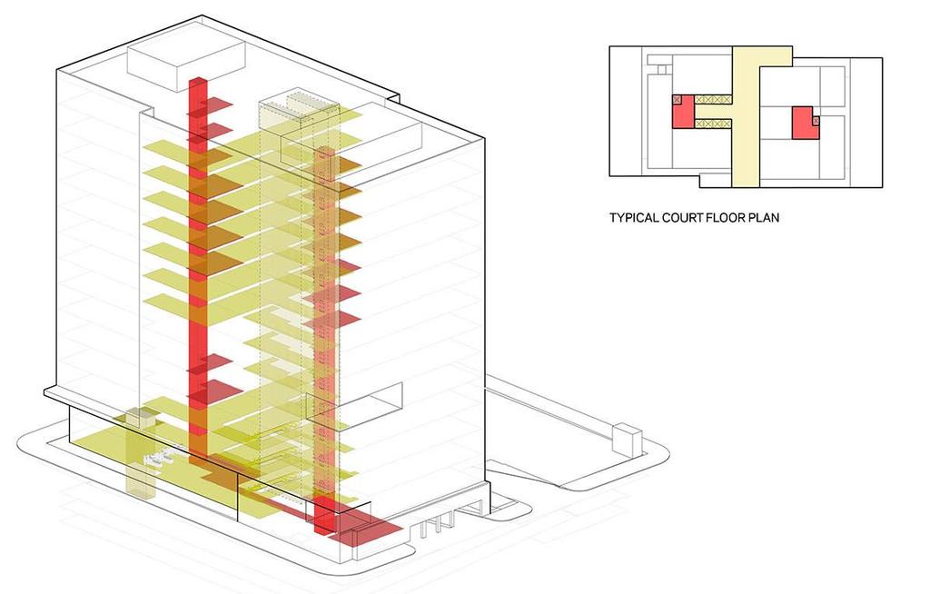
15 Accessibility Civil and Family Courthouse Access to 54 bus routes Nearby commuter rail Adjacent to new bikeway Pedestrian friendly streets 4,300+ spaces of public garage and on-street parking within 3 blocks

16 Density of Law Firms in Travis County Travis County Civil & Family Courthouse Over 1,000 law firms in Travis County Law Offices Per Acre 16
17 Concept 17

18 Courthouse Concept 14 stories 270-feet tall 520,000 gsf 4 level, underground garage 513 parking spaces Secured Judicial parking Oriented to Complement Park Public Views of Park Flexible & Efficient LEED Silver Future Expansion Office Building Space 18

19 CFCH Project Site Drop Off Public Entry Great Streets Profile CFCH Service and Vehicle Entrances off San Antonio Future Expansion Space 19
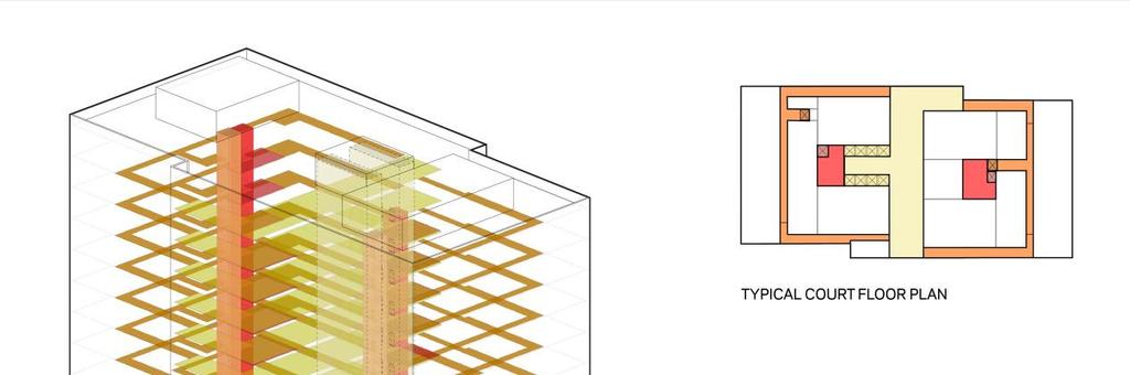

20 Circulation Zones Public In-Custody Judicial 20


21 CFCH Level - 01 Safe Waiting / Non-Profit Support or Potential Retail Elevated Security Station Covered Portico and Outdoor Area 2-Story Atrium 2-Story Space Increases Usability 21


22 Typical Court Floor Multiple meeting spaces/conference rooms Jury Deliberation Rooms Public Seating in corridor N 22

23 Shading Analysis Auction Oaks not shaded by CFCH - April 10 th September 1 st 6-hrs of continuous sunlight - March 10 th October 12 th Only impact occurs during winter months when trees are dormant 23
24 Program Budget 24

25 Preliminary Program Budget Preliminary Program Budget Program Total (Recommended Bond Amount) Includes - Construction Costs, Owner s FF&E and Misc. $ 291,600,000 Budget predicated on November 2015 Bond Referendum Travis County average home value $250,000 Based on 2014 assessed values 25
26 Regional Courthouse Comparison Pacific $ 875 Mountain $ 360 East North Central $ 353 Mid-Atlantic $ 353 West South Central $ 451 South Atlantic $ 377 Travis County CFCH $ 447 Given location and timing of construction, CFCH passes Test of Reasonableness. 26
27 Project Contact Information newtraviscountycourthouse.com 27
Virginia Street Bus RAPID Transit Extension Project. Environmental Assessment (EA) Presentation Public Hearing June 22, 2017
 Presentation Public Hearing June 22, 2017") Virginia Street Bus RAPID Transit Extension Project Environmental Assessment (EA) Presentation Public Hearing June 22, 2017 Presentation to RTC July 17, 2015 Presentation Overview Project Timeline Environmental
Virginia Street Bus RAPID Transit Extension Project Environmental Assessment (EA) Presentation Public Hearing June 22, 2017 Presentation to RTC July 17, 2015 Presentation Overview Project Timeline Environmental
S T A T I O N A R E A P L A N
 The Circulation and Access Plan describes vehicle, pedestrian, and transit improvements recommended within the Concept Plan. In order to create and sustain a vibrant business district that provides pedestrian-friendly
Elmhurst Metra Station. Public Hearing Wednesday - November 30, 2016
 Elmhurst Metra Station Public Hearing Wednesday - November 30, 2016 Agenda Introduction to Hearing Format - Presentation (20 Minutes) - Exhibits/Workstations - Record (Comment Cards, Court Reporter)
MEETING Agenda. Introductions. Project Overview. Key Study Components. Alternative Station Concepts. Preferred Station Concept. Next Steps.
 City GARLAND Council ROADVISION Briefing STUDY VISION STUDY Dallas, TX April 8, 2010 1 1 MEETING Agenda Introductions Project Overview Key Study Components Alternative Station Concepts Preferred Station
INNER LOOP EAST. AIA Rochester Annual Meeting November 13, 2013 TRANSFORMATION PROJECT. Bret Garwood, NBD Erik Frisch, DES
 INNER LOOP EAST TRANSFORMATION PROJECT AIA Rochester Annual Meeting November 13, 2013 Bret Garwood, NBD Erik Frisch, DES Why? We are building a city that encourages walking, biking and enjoying the outdoor
San Jose Transportation Policy
 San Jose Transportation Policy Protected Intersections in LOS Policies to Support Smart Growth Presented by: Manuel Pineda City of San Jose Department of Transportation Bay Area Map San Francisco Oakland
Commerce Street Complete Street Project from Good Latimer Expressway to Exposition Avenue
 Commerce Street Complete Street Project from Good Latimer Expressway to Exposition Avenue T A N Y A B R O O K S A S S I S T A N T D I R E C T O R M O B I L I T Y P L A N N I N G M O B I L I T Y A N D S
In station areas, new pedestrian links can increase network connectivity and provide direct access to stations.
 The Last Mile Planning for Pedestrians Planning around stations will put pedestrians first. Making walking to stations safe and easy is important; walking will be a part of every rapid transit Accessible
Transportation Corridor Studies: Summary of Recommendations
 Transportation Corridor Studies: Summary of Recommendations Route 4 Corridor Study: Route 10 Corridor Study: Route 44 Corridor Study: Route 175 Corridor Study: Route 5/15 Corridor Study: Rentschler Field
Corpus Christi Metropolitan Transportation Plan Fiscal Year Introduction:
 Introduction: The Safe, Accountable, Flexible, Efficient Transportation Equity Act: A Legacy for Users (SAFETEA-LU) has continued the efforts started through the Intermodal Surface Transportation Efficiency
Footpath design. A guide to creating footpaths that are safe, comfortable, and easy to use
 Footpath design A guide to creating footpaths that are safe, comfortable, and easy to use November 2013 Contents Introduction / 1 Zoning system / 2 Width / 4 Height / 5 Surface / 5 Footpath elements /
THIRD&GRAND. Public Workshop #1. Transportation Hub Area Plan. June 12, 2013
 Transportation Hub Area Plan Public Workshop #1 June 12, 2013 Agenda Study Background Who is Involved Process and Schedule Planning Area and Project Site The Opportunity Site Analysis Land Use/Zoning Transportation
Fitting Light Rail through Well-established Communities
 Fitting Light Rail through Well-established Communities San Francisco 2008 Michael D. Madden Chief, Project Development, Maryland Transit Administration Project Setting Located inside the Capital Beltway
Norfolk Tide LRT System Weaving Transit in Downtown Norfolk
 Rail-Volution 2010 Weaving Transit into Existing Communities Norfolk Tide LRT System Weaving Transit in Downtown Norfolk Dan Meyers, AICP URS, Planning Manager Minneapolis, Minnesota Norfolk Tide LRT Alignment
GENERAL. 1. Description
 GENERAL 1. Description This standard identifies minimum requirements that shall be met for all Bus Stops in the design and construction of elements for Arlington County Horizontal Design Standards. This
21.07 TRANSPORT CONNECTIVITY AND INFRASTRUCTURE
 21.07 TRANSPORT CONNECTIVITY AND INFRASTRUCTURE 21.07-1 Connectivity and Choice Transport connectivity and mode choice are critical to achieving productive, sustainable and socially just cities. Travel
Bicycle and Pedestrian Advisory Committee (BPAC) November 21, 2013
 November 21, 2013") Bicycle and Pedestrian Advisory Committee (BPAC) November 21, 2013 OVERALL LAND USE CONCEPT Overall Broadway Valdez District: 95.5 acres (35.1 acres right-of ways + 60.4 acres developable land) Plan Subareas:
Bicycle and Pedestrian Advisory Committee (BPAC) November 21, 2013 OVERALL LAND USE CONCEPT Overall Broadway Valdez District: 95.5 acres (35.1 acres right-of ways + 60.4 acres developable land) Plan Subareas:
D O W N T O W N B A S E B A L L
 D O W N T O W N B A S E B A L L 1 Urban THREE GENERATIONS 2 Multipurpose 3 Revitalized Urban Bring out the best of San Jose 4 4 th GENERATION BUILDING A CITY PETCO Park San Diego, California THE BEST URBAN
Plant City Walk-Bike Plan
 Plant City Walk-Bike Plan Plant City Commute Mode Share 2.2% 1.4% 2.9% Drove alone 10.2% Carpooled Public transportation (0.1%) Walked Used a Bike (0.4%) 82.9% Taxicab, motorcycle, or other means Worked
Public Meeting #1 January 30, 2018
 Public Meeting #1 January 30, 2018 Meeting Outline Mayor s Introduction Presentation Q&A Group Activities Wrap-up Presentation Outline Introduction Existing Conditions Market Assessment Break-out Setup
ROUTE 81 CORRIDOR STUDY DESIGN CONCEPTS
 RT 81 Corridor Study CLINTON ROUTE 81 CORRIDOR STUDY DESIGN CONCEPTS View north on High Street, with potential improvements to the streetscape Draft Recommendations November 8 th, 2018 TOWN OF CLINTON
Circulation in Elk Grove includes: Motor vehicles, including cars and trucks
 Circulation, as it is used in this General Plan, refers to the many ways people and goods move from place to place in Elk Grove and the region. Circulation in Elk Grove includes: Motor vehicles, including
DeLand. DeBary. Sanford/SR 46. Lake Mary. Longwood Altamonte Springs. Maitland. Winter Park/Park Avenue
 P DeLand system map 2-hour off-peak service in each direction Up to 3-car train set 30-minute peak service in each direction from: 5:30 am 8:30 am 3:30 pm 6:30 pm P DeBary P PHASE 2 Sanford/SR 46 P Lake
CITY OF BLOOMINGTON COMPLETE STREETS POLICY
 CITY OF BLOOMINGTON COMPLETE STREETS POLICY POLICY OBJECTIVE: The City of Bloomington will enhance safety, mobility, accessibility and convenience for transportation network users of all ages and abilities,
Purpose and Need. Chapter Introduction. 2.2 Project Purpose and Need Project Purpose Project Need
 Chapter 2 Purpose and Need 2.1 Introduction The El Camino Real Bus Rapid Transit (BRT) Project (Project) would make transit and other transportation improvements along a 17.6-mile segment of the El Camino
8/21/2013 THE UNIVERSITY OF TEXAS AT AUSTIN CAMPUS MASTER PLAN. Board of Regents Meeting Academic Affairs Committee May 2013 ACCOMMODATING GROWTH
 THE UNIVERSITY OF TEXAS AT AUSTIN CAMUS MASTER LAN Board of Regents Meeting Academic Affairs Committee May 2013 1 ACCOMMODATING GROWTH 2 1 CAMUS ZONES Core 196 acres Central 182 acres East 52 acres 3 FAR
Hennepin County Transportation Department
 Hennepin County Transportation Department Complete Streets Design and Implementation Prepared for the Complete Streets Task Force Craig Twinem, P.E. Design Division Manager Tom Johnson, P.E. Transportation
ATTACHMENT 4 - TDM Checklist. TDM Checklist Overview
 ATTACHMENT 4 - TDM Checklist TDM Checklist Overview The proposed checklist rates developments on the degree to which they are TDM and transit supportive. Points are assigned based on the level of transit
Berkeley Strategic Transportation Plan A-76
 Berkeley Strategic Transportation Plan A-76 Appendices 1. A Team Effort 2. Where We ve Been A-11 Berkeley Strategic Transportation Plan Alameda County Transportation Plan Alameda County will be served
Two ramping arrangements are possible: Place two ramps about 28 inches apart so the horse can be led between them for mounting.
 Disclaimer: NARHA recommends that you obtain a copy of the ADAAG as well as accessibility regulations set by your state before you design, construct or alter your facility. Mounting Ramps The necessity
5 CIRCULATION AND STREET DESIGN
 5 CIRCULATION AND STREET DESIGN This chapter describes circulation and streetscape improvements proposed for the Northwest Chico Specific Plan Area. It includes detailed design specifications for existing
Marshalltown Municipal Transit ADA PARATRANSIT APPLICATION
 Marshalltown Municipal Transit ADA PARATRANSIT APPLICATION The Americans with Disabilities Act (ADA) requires public transit agencies that provide fixedroute service to provide complementary Paratransit
Final Study Recommendations AMES TRANSIT FEASIBILITY STUDY. For Public Review and Comment. October Ames Transit Feasibility Study
 AMES TRANSIT FEASIBILITY STUDY Final Study Recommendations For Public Review and Comment October 2007 Meeting Agenda Existing Service Future Service Transit Feasibility Study Study Purpose/Goals Methodology
Bike San Mateo County San Mateo County Bicycle Plan Recommendations August 30, 2010
 Policy and Procedures Develop and Implement a Complete Streets Policy to comply with DD-64-R1 and AB1358 Commencing January 1, 2011, AB1358 requires that the legislative body of a city or county, upon
DALLAS MIDTOWN REDEVELOPMENT PLAN FOCUS NORTH TEXAS Peer Chacko, AICP, Assistant Director, City of Dallas
 DALLAS MIDTOWN REDEVELOPMENT PLAN FOCUS NORTH TEXAS 2014 Peer Chacko, AICP, Assistant Director, City of Dallas Dallas Midtown: Strategic growth area Future transit node 2 Peterson Road Study Area Galleria
Ballston Station Multimodal Study WMATA and Arlington County. Meeting Minutes
 Date of Meeting: June 10, 2010 Location: Ballston Metrorail Station and NRECA Building 4301 Wilson Blvd, Arlington, VA Subject: Ballston Station Multimodal Study Stakeholder Meeting #1 Summary: This first
Transit boulevard: A new road type for Sydney s Growth Centres
 Transit boulevard: A new road type for Sydney s Growth Centres Cleaver, M. A., de Roos, M. P., NSW Centre for Road Safety, Roads and Traffic Authority, NSW Collins, G., Network Services, Roads and Traffic
Project Development & Environment (PD&E) Study Public Hearing January 12 th, 2006
 Study Public Hearing January 12 th, 2006") Project Development & Environment (PD&E) Study Public Hearing January 12 th, 2006 Public Hearing Regulations Chapter 23 of United States Code 128 Title 40 of the Code of Federal Regulations Parts 1500
Project Development & Environment (PD&E) Study Public Hearing January 12 th, 2006 Public Hearing Regulations Chapter 23 of United States Code 128 Title 40 of the Code of Federal Regulations Parts 1500
FOR SALE. 202 Pacific Avenue, Bremerton, WA Historic Bremerton Trust and Savings Building
 FOR SALE 202 Pacific Avenue, Bremerton, WA 98337 Historic Bremerton Trust and Savings Building PROPERTY INFORMATION PRICE $1,750,000 BUILDING SIZE LOT SIZE 10,080 sq. ft. 4,792 sq. ft. (0.11 Acres) # OF
Exhibit 1 PLANNING COMMISSION AGENDA ITEM
 Exhibit 1 PLANNING COMMISSION AGENDA ITEM Project Name: Grand Junction Circulation Plan Grand Junction Complete Streets Policy Applicant: City of Grand Junction Representative: David Thornton Address:
Item B1 November 19, 2009
 November 19, 2009 Planning and Development Department Land Use Planning Division DATE: November 19, 2009 STAFF REPORT TO: FROM: SUBJECT: Members of the Transportation Commission Elizabeth Greene Senior
The Public Safety Complex Southampton MA. a critical time
 The Public Safety Complex Southampton MA a critical time April 7, 2015 1863: Southampton constructs a new school house 1927: Southampton discontinues use of facility as a school December 1946: Southampton
City Council Briefing March 18, Draft Working Ideas for Confirmation of Direction
 City Council Briefing March 18, 2014 Draft Working Ideas for Confirmation of Direction Draft Working Ideas for Confirmation of Direction Overall Study Area Regional Population Growth Plan for Today and
ADA Access Standards for Swimming Pools, Wading Pools, and Spas
 ADA Access Standards for Swimming Pools, Wading Pools, and Spas The sports, places of amusement, and outdoor developed areas subcommittees each provided recommendations in this area. The recommendations
Policy 1136: Unclaimed Personal Property
 Policy 1136: Unclaimed Personal Property Responsible Office: Procedures: Office of Parking and Transportation Procedures for Impounded Bicycles Related Law & Policy: Unclaimed Personal Property Regulation
VTA Development Review Program Annual Report for 2015
 VTA Development Review Program Annual Report for 2015 Web Version May 13, 2016 Presentation Outline I. Background II. Data Snapshot a. Development Review Activity for 2015 b. Select Projects Under Construction
2. Context. Existing framework. The context. The challenge. Transport Strategy
 Transport Strategy Providing quality connections Contents 1. Introduction 2. Context 3. Long-term direction 4. Three-year priorities 5. Strategy tree Wellington City Council July 2006 1. Introduction Wellington
June 11, RE: Comments on the ENF for The Boston Garden project, MEPA # Dear Mr. Sullivan:
 June 11, 2013 Secretary Richard K. Sullivan, Jr. Executive Office of Energy and Environmental Affairs (EEA) Attn: Deirdre Buckley 100 Cambridge Street, Suite 900 Boston MA 02114 RE: Comments on the ENF
CHAPTER 3. Transportation and Circulation
 CHAPTER 3 Transportation and Circulation 3.0 TRANSPORTATION AND CIRCULATION This chapter evaluates traffic circulation, transit, parking, pedestrian, bicycle, and rail operational conditions in the Project
FY Transportation Capital Improvement Plan Update Arlington Committee for Transportation Choices
 FY 2017-2026 Transportation Capital Improvement Plan Update Arlington Committee for Transportation Choices November 1, 2017 Forecasted Growth Arlington continues to grow with a shift towards multi-family
Exhibit B: Proposed amendments to the Transportation Element of the Oakland Comprehensive Plan
 Exhibit B: Proposed amendments to the Transportation Element of the Oakland Comprehensive Plan TRANSPORTATION Introduction An important aspect of any community is its transportation system, the means by
newly constructed and altered recreation facilities guidelines for newly constructed and altered buildings and facilities subject to the ADA.
 1 Americans with Disabilities Act Accessibility Guidelines Recreation Facilities 2 Final Rule Federal Register September 3, 2002 3 Architectural and Transportation Barriers Compliance Board 36 CFR Part
Circular Turning Space. 8 Significant Changes to the ICC A
 8 Significant Changes to the ICC A117.1 2017 304.3.1 Circular Turning Space CHANGE TYPE: Modification CHANGE SUMMARY: Within new buildings, the size of a circular turning space has been increased from
Incentive Zoning. Zoning Ordinance Advisory Committee June 21, Pam Thompson, Senior Planner, Sustainable Development and Construction
 Incentive Zoning Zoning Ordinance Advisory Committee June 21, 2018 Pam Thompson, Senior Planner, Sustainable Development and Construction Presentation Overview Stakeholder questions Updated charts Design
Corridor Advisory Group and Task Force Meeting #10. July 27, 2011
 Corridor Advisory Group and Task Force Meeting #10 July 27, 2011 1 Agenda Recap CAG/TF #9 Public Meeting #2 Summary Single Mode Alternatives Evaluation Results Next Steps 2 3 CAG/TF #9 Recap CAG /TF #9
COUNCIL POLICY NAME: COUNCIL REFERENCE: 06/119 06/377 09/1C 10llC 12/1C INDEX REFERENCE: POLICY BACKGROUND
 COUNCIL POLICY NAME: COUNCIL ADVISORY COMMITTEES - TERMS OF REFERENCE ISSUED: APRIL 3, 2006 AMENDED: NOVEMBER 27, 2006 NOVEMBER 23, 2009 JANUARY 11, 2010 DECEMBER 17, 2012 POLICY COUNCIL REFERENCE: 06/119
South King County High-Capacity Transit Corridor Study
 HIGH-CAPACITY TRANSIT CORRIDOR STUDY South King County Corridor South King County High-Capacity Transit Corridor Study Corridor Report August 2014 South King County High Capacity Transit Corridor Report
Downtown Naples Mobility and Connectivity Study. Naples City Council Presentation January 2017
 Downtown Naples Mobility and Connectivity Study Naples City Council Presentation January 2017 Agenda 1. Introduction 2. Scope Review 3. Project Schedule 4. Existing Conditions 5. Public Charrette 6. Mobility
Alaskan Way, Promenade, and Overlook Walk Final EIS
 I-065-001 As described in Section 3.7.2 of the Draft EIS, the loss of on-street and off-street parking may require drivers to park off-street or travel farther to find available on-street or off-street
OAKRIDGE + AMENITIES OAKRIDGE CENTRE - ISSUES AND DIRECTIONS
 OAKRIDGE + AMENITIES OAKRIDGE CENTRE - ISSUES AND DIRECTIONS Council Presentation May 29 th, 2013 OAKRIDGE CENTRE REZONING Introduction PURPOSE Awareness of issues related to Oakridge Centre Rezoning Receive
Introduction. North 12 th Complete Street Project Overview
 Introduction On Wednesday, March 1, 2017, the City of Sacramento, in partnership with Sacramento Regional Transit District and the Sacramento Housing and Redevelopment Agency, hosted a community outreach
VILLAGE OF ASHWAUBENON. Community Facilities Referendum
 VILLAGE OF ASHWAUBENON Community Facilities Referendum Background Auditorium and Pool studied for over 20 years 1992 School District referendum (District-wide upgrades) 1999 School District referendum
ACTIVE TRANSPORTATION
 ACTIVE TRANSPORTATION Mobility 2040 Supported Goals Improve the availability of transportation options for people and goods. Support travel efficiency measures and system enhancements targeted at congestion
Summary of Comments Public Information Meeting Wieuca Road at Phipps Boulevard Intersection Improvements June 7, 2017
 The Public Meeting for the Wieuca Road at Phipps Boulevard Intersection Improvement project was held on at the Wieuca Road Baptist Church, located at 3626 Peachtree Road, Atlanta, GA 30326. There were
Employment 8,881 17,975 9,094. Households 18,990 31,936 12,946
 This section describes the future transportation environment of the UW Tacoma campus and surrounding area. A description of the future conditions on campus in terms of the street system, traffic and intersection
City of Walnut Creek TELEGRAPH AVENUE BART LINE SELF-GUIDED TOD TOUR 19TH STREET BART STATION
 TELEGRAPH AVENUE City of Walnut Creek BART LINE SELF-GUIDED TOD TOUR 19TH STREET BART STATION Self-Guided TOD Tour With the Walnut Creek BART Station located squarely within its boundaries, the West Downtown
SFMTA s Services for Seniors and People with Disabilities. San Francisco Municipal Transportation Board July 17, 2018
 SFMTA s Services for Seniors and People with Disabilities San Francisco Municipal Transportation Board July 17, 2018 SFMTA s Commitment to Access Address issues of accessibility across all transportation
SETTINGS AND OPPORTUNITIES MOBILITY & ACCESS
 7 mobility & access how do people use el camino what is it like to drive on el camino/to park along el camino what is the pedestrian experience like what is the role of transit along the corridor what
Morristown, NJ Complete Streets Policy
 Morristown, NJ Complete Streets Policy Introduction A Complete Street is defined as a means to provide safe access for all users by designing and operating a comprehensive, integrated, connected multi-modal
El Centro Mobility Hub
 The El Centro drive shed comprises a major portion of the El Centro downtown area, which is well served by bus routes. The proposals intend to promote use of public transit through improvements and enhancements
Roadway Classification Design Standards and Policies. Pueblo, Colorado November, 2004
 Roadway Classification Design Standards and Policies Pueblo, Colorado November, 2004 Table of Contents Page Chapter 1. General Provisions 1.1 Jurisdiction 3 1.2 Purpose and Intent 3 1.3 Modification 3
Arnold Hinojosa
 Policy Analysis of the Mass Transit Challenges Facing Rapidly Growing Southern and Western Cities and How These Challenges Can Be Addressed Using the Model Set by Chicago Arnold Hinojosa ahinojosa@kentlaw.edu
Better Market Street. Engineering, Maintenance & Safety Committee (EMSC) February 28, 2018
 February 28, 2018") Better Market Street Engineering, Maintenance & Safety Committee (EMSC) February 28, 2018 1 Market Street Market Street - San Francisco by rulenumberone2 2 Market Street is the... City s busiest pedestrian
Better Market Street Engineering, Maintenance & Safety Committee (EMSC) February 28, 2018 1 Market Street Market Street - San Francisco by rulenumberone2 2 Market Street is the... City s busiest pedestrian
Prepared for: August 4 th, Presented by: Eric Callender Ecosign VP Adam Schroyen Resort Planner
 TAHOE DONNER PHASE 1 & 2 INVENTORY AND TECHNICAL ASSESSMENT Prepared for: August 4 th, 2017 Presented by: Eric Callender Ecosign VP Adam Schroyen Resort Planner ECOSIGN RESORT PLANNERS (2016) LTD. Whistler,
San Bernardino County Non-Motorized Transportation Plan - Chapter 5
 City of Upland Population 76,106 City Overview The City of Upland was incorporated on May 15, 1906, after previously being named North Ontario. The City was originally established as an irrigation colony
TRAFFIC IMPACT STUDY CRITERIA
 Chapter 6 - TRAFFIC IMPACT STUDY CRITERIA 6.1 GENERAL PROVISIONS 6.1.1. Purpose: The purpose of this document is to outline a standard format for preparing a traffic impact study in the City of Steamboat
NJDOT Complete Streets Checklist
 Background The New Jersey Department of Transportation s Complete Streets Policy promotes a comprehensive, integrated, connected multi-modal network by providing connections to bicycling and walking trip
Bicycle and Pedestrian Plans and Improvements
 Bicycle and Pedestrian Plans and Improvements Presented to the City Council By Randle Harwood, Planning and Development, and Richard Zavala, Parks and Community Services September 24, 2013 Purpose Review
TRAVEL PLAN: CENTRAL EUROPEAN UNIVERSITY CAMPUS REDEVELOPMENT PROJECT TRAVEL PLAN. Central European University Campus Redevelopment Project.
 TRAVEL PLAN Central European University Campus Redevelopment Project Page 1 Table of Contents Introduction... 3 Background... 7 Building Users... 7 Transportation in Community Consultation... 7 Summary
Americans with Disabilities Act Transition Plan for Public Right-of-Way Improvements
 Americans with Disabilities Act Transition Plan for Public Right-of-Way Improvements Prepared by: Public Works Department Engineering Division October 2015 Table of Contents Section I Introduction.. 3
Idea-66: Westbound I-66 Inside the Beltway
 Southeastern Institute of Research Idea-66: Westbound I-66 Inside the Beltway Stakeholder Telephone Survey Pulsar Advertising December 22, 2004 G 1 Agenda I. Objectives II. Methodology III. Key Findings
Bus Rapid Transit Plans
 Twin Cities Region Bus Rapid Transit Plans ULI Minnesota Workshop Connecting Bus Rapid Transit to the Community December 15, 2009 John Levin Director of Service Development Metro Transit Metropolitan Area
Exit 13/Golden Triangle Study FREQUENTLY ASKED QUESTIONS
 FREQUENTLY ASKED QUESTIONS How will you improve traffic in the Golden Triangle? One main goal of this study is to examine the current traffic patterns of the area and propose ways to improve the traffic.
Speed Limits Study and Proposal. Public Input Session: 8/14/13
 Speed Limits Study and Proposal Public Input Session: 8/14/13 Why is Decatur a unique place for this project? First Community Transportation Plan in the nation with a Health Impact Assessment. Strong sense
Downtown BRT Corridor Alternatives Review: 1 st, 2 nd, 3 rd and 4 th Avenue. Bus Rapid and Conventional Transit Planning and Design Services
 Downtown BRT Corridor Alternatives Review: 1 st, 2 nd, 3 rd and 4 th Avenue Bus Rapid and Conventional Transit Planning and Design Services City of Saskatoon February 2018 Project Team HDR Corporation
GLYNN COUNTY MANAGER S OFFICE 1725 Reynolds Street, Third Floor, Brunswick, GA Phone: (912) Fax: (912)
 Fax: (912)") GLYNN COUNTY MANAGER S OFFICE 1725 Reynolds Street, Third Floor, Brunswick, GA 31520 Phone: (912) 554-7401 Fax: (912) 554-7596 www.glynncounty.org MEMO TO: FROM: The Honorable Commissioners Alan Ours,
GLYNN COUNTY MANAGER S OFFICE 1725 Reynolds Street, Third Floor, Brunswick, GA 31520 Phone: (912) 554-7401 Fax: (912) 554-7596 www.glynncounty.org MEMO TO: FROM: The Honorable Commissioners Alan Ours,
THE PEOPLE OF THE CITY OF LOS ANGELES DO ORDAIN AS FOLLOWS:
 CPC-2016-4216-CA Proposed Ordinance with Recommended Changes Page 1 ORDINANCE NO. An ordinance amending Sections 12.03, 12.21 and 12.26 of the Los Angeles Municipal Code (LAMC) to improve and refine the
Uptown Houston November 2014
 Uptown Houston November 2014 City of Houston Leads the Nation in Job Growth Leads the Nation in Exports Record Construction Permits - $ 8 Billion Most Competitive Metro in America - Forbes New Development
[DRAFT] Bicycle Parking & Removal
![[DRAFT] Bicycle Parking & Removal](/thumbs/78/76931309.jpg "[DRAFT] Bicycle Parking & Removal") [DRAFT] Bicycle Parking & Removal Policy Type: Administrative Responsible Office: VCU Office of Sustainability, Facilities Management, Division of Administration Initial Policy Approved: MM/DD/YYYY Current
[DRAFT] Bicycle Parking & Removal Policy Type: Administrative Responsible Office: VCU Office of Sustainability, Facilities Management, Division of Administration Initial Policy Approved: MM/DD/YYYY Current
National Bicycle and Pedestrian Documentation Project INSTRUCTIONS
 National Bicycle and Pedestrian Documentation Project INSTRUCTIONS The National Documentation Project (NBPD) is an annual bicycle and pedestrian count and survey effort sponsored by the Institute of Transportation
2018 BOND PROPOSAL TO CONSTRUCT AND RENOVATE SCHOOL FACILITIES AND IMPROVE SECURITY
 2018 BOND PROPOSAL TO CONSTRUCT AND RENOVATE SCHOOL FACILITIES AND IMPROVE SECURITY Dr. Chrys Sweeting, Superintendent Mr. Brian Lewis, Executive Director of Operations Bonds to Construct and Renovate
Proposed. City of Grand Junction Complete Streets Policy. Exhibit 10
 Proposed City of Grand Junction Complete Streets Policy Exhibit 10 1 City of Grand Junction Complete Streets Policy Vision: The Complete Streets Vision is to develop a safe, efficient, and reliable travel
Stakeholder Meeting Handouts. January 2013
 January 2013 Stakeholder Meeting Handouts The Case FOR Parking Minimum Requirements Reduce street congestion around the development site Avoid parking spillover Create orderly development patterns Anticipate
Moving Cambridge. City of Cambridge Transportation Master Plan Public Consultation Centre. March 7, :00 8:00 PM.
 City of Cambridge Transportation Master Plan Public Consultation Centre March 7, 2018 5:00 8:00 PM Region of Waterloo City of Cambridge Transportation Master Plan Public Consultation Centre March 7, 2018
New Park Avenue Corridor West Hartford
 New Park Avenue Corridor West Hartford Current TOD Investment in the Corridor Mixed-use building currently under development by the Trout Brook Realty Advisors: a separate non-profit corporation, established
7/23/2017 VIA . Michael Hanebutt City of Sacramento Community Development Department 300 Richards Boulevard, 3 rd Floor Sacramento, CA 95811
 7/23/2017 VIA EMAIL Michael Hanebutt City of Sacramento Community Development Department 300 Richards Boulevard, 3 rd Floor Sacramento, CA 95811 RE: 65 th Street Apartments (DR17-220) Dear Mr. Hanebutt:
Existing Conditions. Background Document Review. Bicycle and Pedestrian Connectivity Master Plan
 Existing Conditions Background Document Review The background document review for the Franklin Street Parking Management and Active Transportation Plan ( the Plan ) examines master plan documents for their
General Design Factors
 Chapter 3: 3-1.0 Introduction General Design Factors Mn/DOT s goals include encouraging and accommodating safe bicycling. From a design perspective, these goals are achieved by first having an understanding
ORDINANCE NO
 1 Sponsored by: Councilmembers Stan Flemming, Connie Ladenburg, and Rick Talbert 2 Requested by: Executive/Public Works and Utilities - Transportation Services 3 4 5 6 7 10 11 ORDINANCE NO. 2014-445 12
31. Rosses Point Mini-Plan
 County Development Plan 2017-2023 Volume 2, Chapter 31 Rosses Point Mini-Plan 31. Rosses Point Mini-Plan Village profile Rosses Point is a coastal settlement located approximately 8 km north-west of Sligo