Uptown Houston November 2014
|
|
|
- Gwenda Berry
- 5 years ago
- Views:
Transcription

1 Uptown Houston November 2014
2 City of Houston Leads the Nation in Job Growth Leads the Nation in Exports Record Construction Permits - $ 8 Billion Most Competitive Metro in America - Forbes
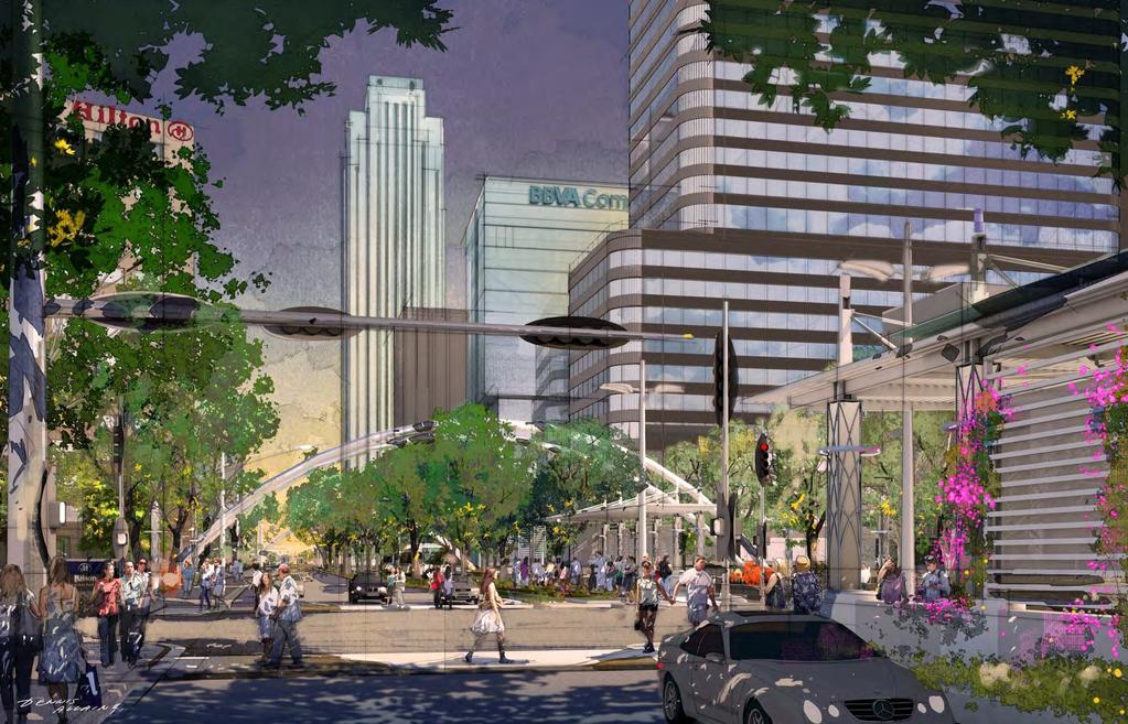
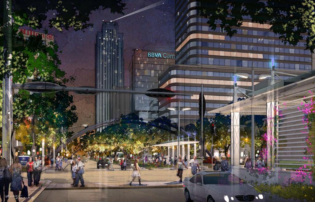
3 New Development

4 GreyStone Group Residential The Palazzi at Uptown Park New Development Belfiore Residential $4 Billion BLVD Place Retail, Office Hanover Residential BHP Billiton Office Landry s Hotel Astoria Residential Gables Post Oak Residential Sola Uptown Residential Office Retail Hotel 4,150,000 Sq. Ft. 675,000 Sq. Ft. 1,850 Rooms St. James Place Office Finger Cos. Residential Apache Office Redstone / BBVA Compass Office, Office 2, Hotel AMLI Residential Gables Westcreek Residential Amegy Bank Office Randall Davis Residential SkyHouse Residential Pelican Residential Residential Mixed Use 8,700 Units M5250 Residential The Galleria III Renovation Hyatt Place Hotel River Oaks District Millennium High Street Residential / Retail Hyatt Regency Hotel Waterwall Place 3009 Post Oak Boulevard Office Broadstone Post Oak Residential Post Galleria Residential Avenue R Residential


5 Uptown Mixed Use 2013 Values Residential $1,500,000,000 30% Office $2,000,000,000 40% Hotel $500,000,000 10% Retail $1,000,000,000 20%

6 Uptown Houston Transit
7 Who Is Being Served? Sector Number Percent Office 48,500 73% Retail / Hotel 18,000 27% Total Core 66, %
8

9 Park and Ride Corridors Transit Centers Northwest: 77 a.m. bus trips 82 p.m. bus trips Park & Ride Lots Commute Corridors Katy: 111 a.m. bus trips 105 p.m. bus trips Westpark: 42 a.m. bus trips 45 p.m. bus trips Southwest: 53 a.m. bus trips 53 p.m. bus trips

10 Uptown Transit Connector West Loop HOV / Northwest Transit Center Post Oak Boulevard Improvements Bellaire / Uptown Transit Center

11 Typical PM Peak Volumes NB Post Oak Boulevard Ramps to Various Destinations I -10 WB 738 I -10 EB 662 US 290 WB 209 North Loop EB Total 1,952 Source: Texas A&M Transportation Institute
12 Typical PM Peak Volumes From San Felipe Ramps to Various Destinations US 59 SB 411 IH 610 SB 394 Woodway WB 222 Woodway EB 255 I-10 WB 200 I-10 EB 200 US 290 WB 79 North Loop EB Total 1,862 Source: Texas A&M Transportation Institute

13 Typical PM Peak Volumes From Westheimer Ramps to Various Destinations US 59 SB 1,014 US 59 NB 190 IH 610 SB 1,624 Woodway WB 410 Woodway EB 414 I-10 WB 421 I-10 EB 270 US 290 WB 154 North Loop EB Total 4,831 Source: Texas A&M Transportation Institute

14 Typical PM Peak Volumes From NB Richmond Ramp to Various Destinations Westheimer WB 327 Westheimer EB 227 Woodway WB 238 Woodway EB 118 I-10 WB 120 I-10 EB 59 US North Loop EB Total 1,285 Source: Texas A&M Transportation Institute
15 P.M. Peak Hour Volumes Entering the West Loop Destination Origin NB SB Total Richmond 1, ,285 Westheimer 4,831 2,828 7,659 San Felipe 1, ,862 Post Oak Boulevard 1, ,952 Total 9,125 3,633 12,758
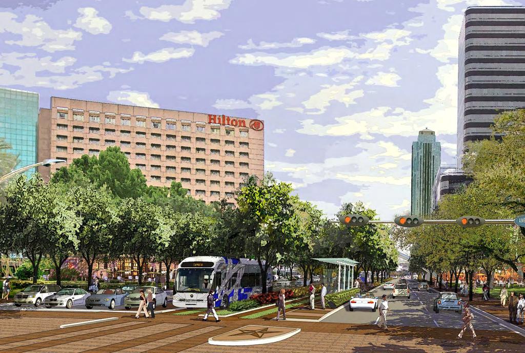
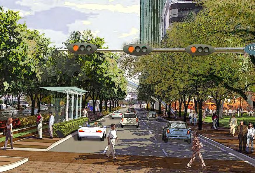
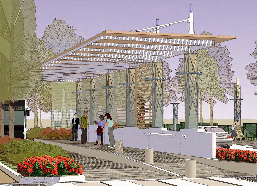
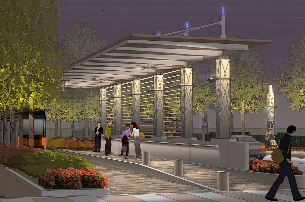
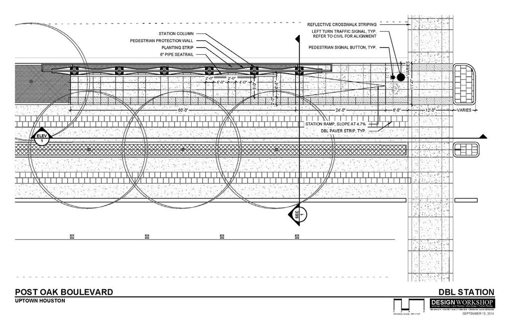
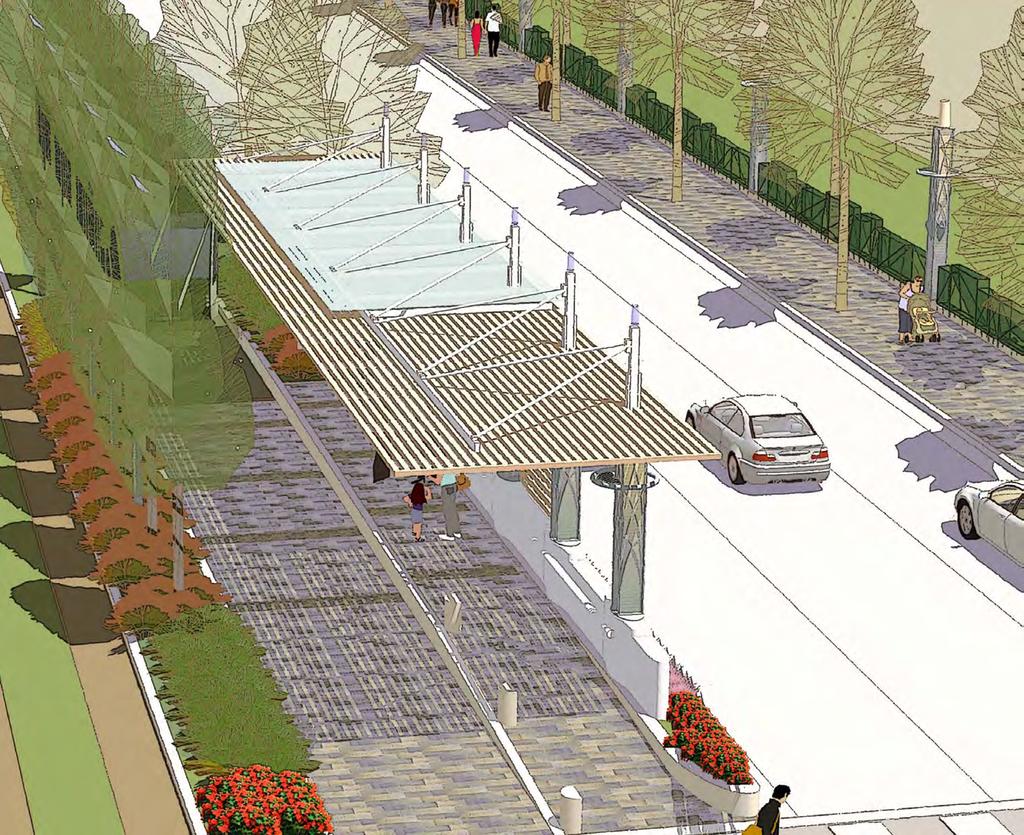
16 West Loop (IH-610) Elevated Dedicated Bus Lanes Proposed Section D D NTS

17 West Loop (IH-610) Elevated Dedicated Bus Lanes - South Portal

18 IH 610 West Loop Most Congested Freeway in Texas Texas Department of Transportation

19
20 Preliminary Drawing
21
22

23 Post Oak Boulevard Improvements Dedicated Bus Lanes Bus Lanes Bus Shelter Bus Shelter Bus Lanes
24
25
26
27
28
29
30
31
32

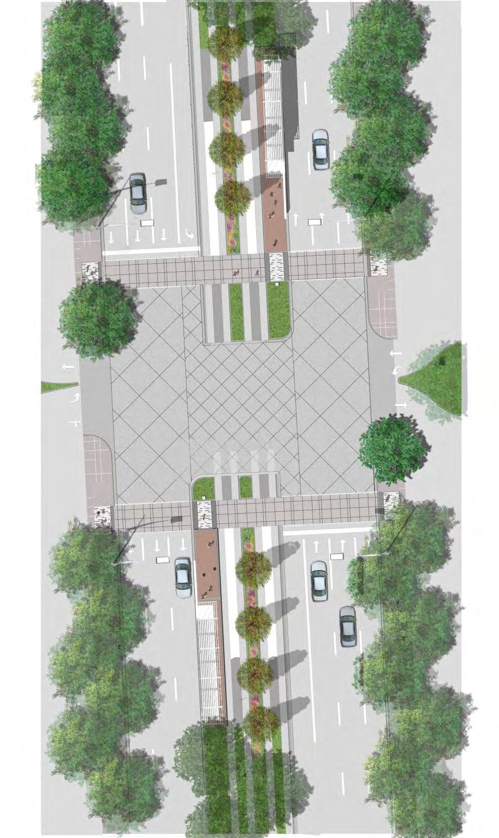
33 Design Typical Intersections
34

35
36
37
38
39
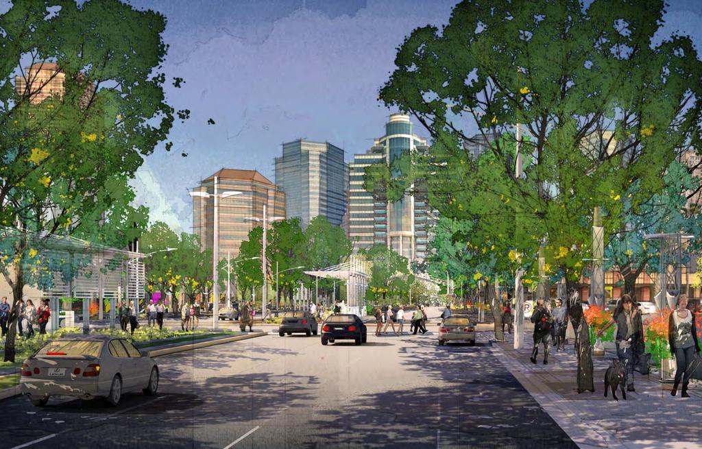
40
41
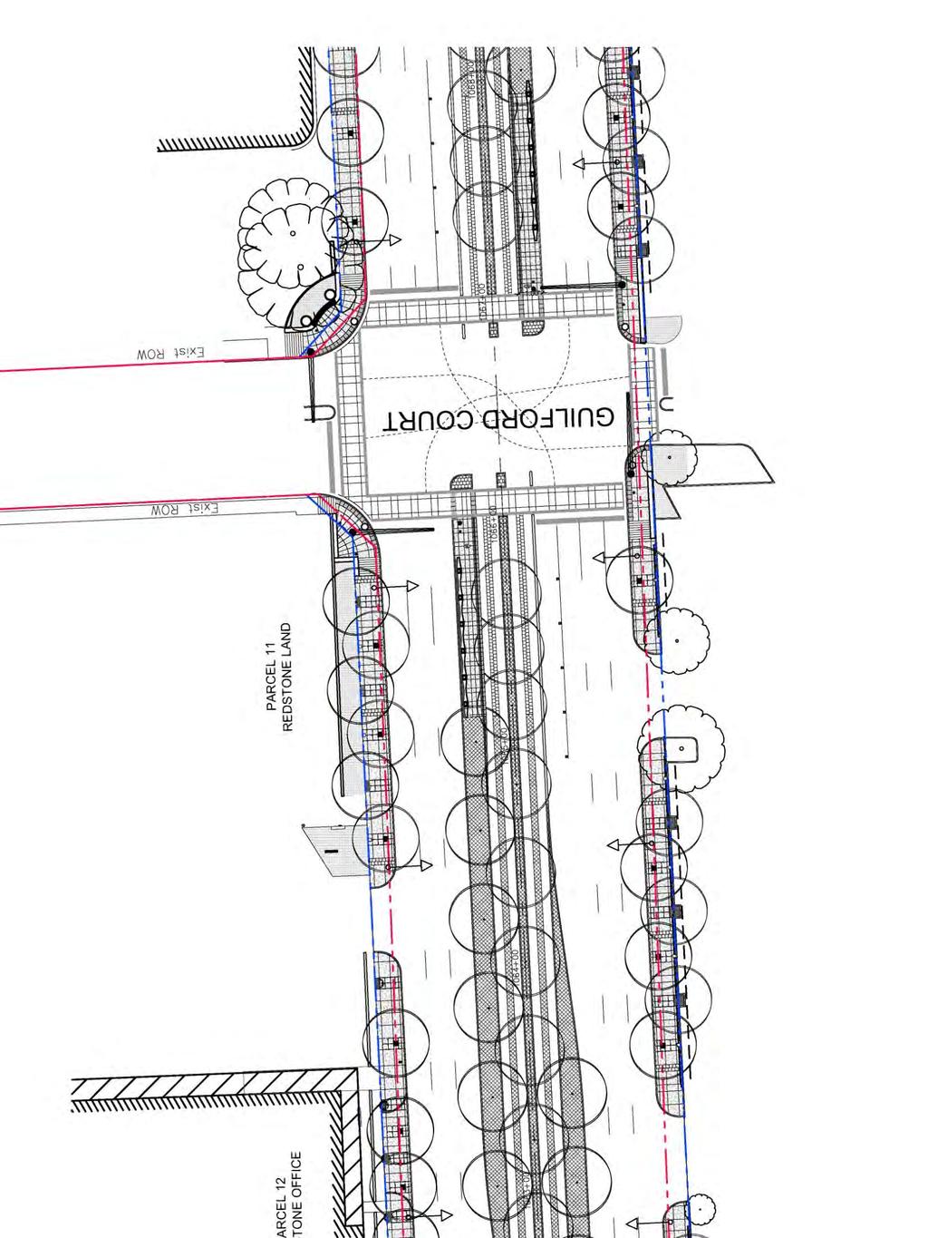
42
43 Travel Time Savings PM Peak Automobile Dedicated Bus Lanes Richmond to minutes 12 minutes* Transit Center to Transit Center 33 minutes 19 minutes* *Includes dwell time for loading and unloading passengers
44 Transit Ridership DBL NWTC and BUTC Daily Riders Daily Riders Mixed Flow on West Loop 14,100 19,800 Elevated Bus Way on West Loop 18,400 25,800
45 Transit Ridership DBL at Maximum Load Points Mixed Flow Per Peak Hour Per Peak Hour AM Peak Hour SB from NWTC 1,040 1,420 AM Peak Hour NB at Westheimer 820 1,090 PM Peak Hour SB from NWTC 980 1,310 NB at Westheimer 770 1,040
46 Transit Ridership Equivalent Number of Automobile Lanes Number of Automobile Lanes Adding Dedicated Bus Lanes has the ability to double the effective person-carrying capacity (nominal 1,500-2,000 passengers per hour each direction for dedicated bus lanes compared to 1,500-2,000 vehicles per hour for the three general traffic lanes in each direction) with only minimal ROW expansion.
47 Post Oak Boulevard Project
48 Post Oak Boulevard Project Richmond to West Alabama
49 Post Oak Boulevard Project West Alabama to Guilford Court
50 Post Oak Boulevard Project Guilford Court to San Felipe
51 Post Oak Boulevard Project San Felipe to West Loop

52 Bellaire / Uptown Transit Center

53 Bellaire / Uptown Transit Center

54 Bellaire / Uptown Transit Center

55 Bellaire / Uptown Transit Center Option 1.1

56 Bellaire / Uptown Transit Center Option 2.1

57 Bellaire / Uptown Transit Center Option 3.1

58 Bellaire / Uptown Transit Center Option 4.1
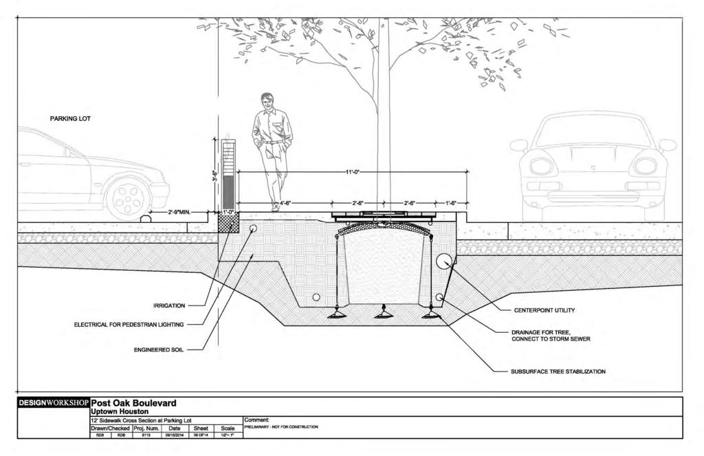
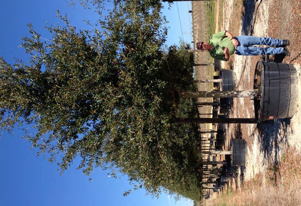
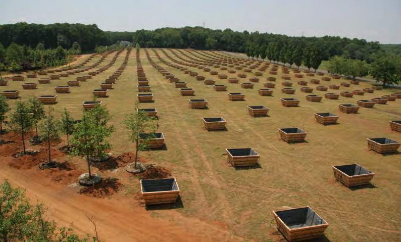
59 Bellaire Uptown Transit Center Budget Overview The original budget was established in 2011 based on three projects: Transit Center with parking T Ramp Dedicated bus lanes
60 Bellaire Uptown Transit Center Budget Overview T-Ramp $ 5,000,000 Utilities/ DBL $ 2,000,000 Transfer $ 5,500,000 Parking $ 4,000,000 Design 10% $ 1,650,000 CM 10% $ 1,650,000 Contingency 10% $ 1,650,000 Right-of-Way $ 4,500,000 Total $ 25,950,000

61 Schedule / Proposed Key Dates
62 March 2015 Post Oak Boulevard Dedicated Bus Lanes Design March 2015 May Bid Construction Projected completion 1 st Quarter 2017 Right-of-Way Acquisition
63 Uptown Transit Preliminary Cost Estimate West Loop / Uptown TxDOT Federal Total NW Transit Center $ 20.0 $ 25.0 $ -- $ 45.0 Post Oak Boulevard $ 76.5 $ -- $ 45.0 $ Bellaire / Uptown Transit Center $ 9.1 $ -- $ 16.9 $ 26.0 TOTAL $ $ 25.0 $ 61.9 $ 192.5
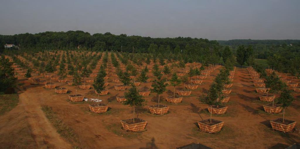
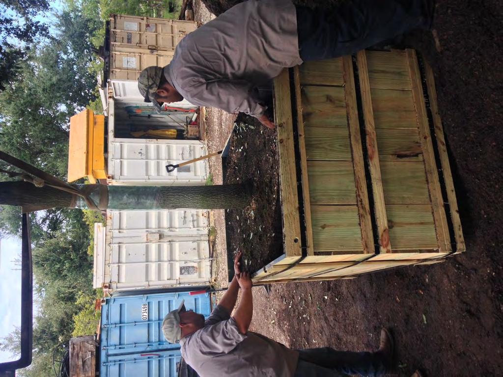
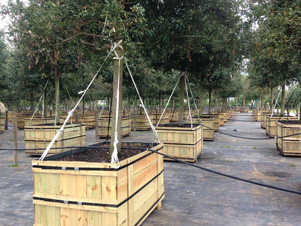
64 Project Status Environmental Clearance Received Categorical Exclusion (CE) from FTA ( ) Received Letter of No Prejudice ( ) Funding TIP commitment of $61.9 million Requested transfer of funds from FHWA to FTA Preparing Grant Application Uptown TIRZ $53 million initial bond issue completed Design Submitted Preliminary Engineering Report to City of Houston Submitted Preliminary Engineering Report to METRO Status Awarded Final Design contract Awarded Construction Management contract Awarded contract to purchase 800 trees Request approval of offerings for Right-of-Way acquisitions Request authorization to advertise for construction of sanitary sewer improvements
65
66 Tree Plan Preserve in place Relocate to permanent initially Relocate to custom care / replant Specifically cultivate and grow in specialized boxes New custom grow Limb Rootball Structure Create uniform appearance
67
68
69
70
71 Right-of-Way Acquisition
72 Levels of Oversight Right-of-Way Acquisition Independent Appraisal Right-of-Way Committee Consisting of Non-Property Owner Independent Special Legal Counsel Federal Transit Administration Full Board City of Houston
73 Property Values 2014 Cost Total Total Values Per Sq. Ft. Sq. Ft. Cost Preliminary Noticed $ 133 per sq. ft. 152,000 sq. ft. $ M Protested $ 127 per sq. ft. 152,000 sq. ft. $ M Current Appraisal Average $ 176 per sq. ft. 152,000 sq. ft. $ M
74 Right-of-Way Acquisition Uptown Process
75 Right-of-Way Acquisition Process Uptown Process Planning Phase Independent Appraisals ROW Committee Review and Negotiation Purchase
76 Right-of-Way Acquisition Process Uptown Process Planning Process Define Right-of-Way (ROW) Needed Obtain surveys Meet with property owners
77 Right-of-Way Acquisition Process Uptown Process Independent Appraisals Secure Independent Appraisals Secure review appraisals Identify board members with ownership or direct involvement with property needed
78 Right-of-Way Acquisition Process Uptown Process Review and Negotiate ROW Committee and special outside council reviews all appraisals ROW Committee recommends offers to the board ROW Committee informs board of any board member ownership or direct involvement
79 Right-of-Way Acquisition Process Uptown Process Review and Negotiate Board authorizes offers Board Members with ownership or direct involvement discloses involvement and abstains from voting All offers over $500,000 reviewed by Federal Transit Administration Negotiations with property owners begin
80 Right-of-Way Acquisition Process Uptown Process Purchase Upon successful negotiations, Board approves and authorizes all purchases and compensation amounts Special Counsel renders fairness opinions on all transactions involving Board Properties purchased and deeded to City of Houston Properties which cannot be voluntarily purchased will be referred to City of Houston for possible acquisition by eminent domain
81

82 Northwest Transit Center Northwest Transit Center Memorial Drive

83 Bellaire Uptown Transit Center Post Oak Boulevard Bellaire Uptown Transit Centet

84 Uptown Dedicated Bus Lanes Project Corridor Northwest Transit Center Post Oak Boulevard Bellaire Uptown Transit Center
85
POST OAK BOULEVARD DEDICATED BUS LANES PROJECT
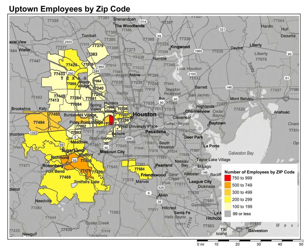
 POST OAK BOULEVARD DEDICATED BUS LANES PROJECT January 2015 Uptown Dedicated Bus Lanes project Post Oak Boulevard Uptown Employees by Zip Code Number of Employees by Zip Code 750 to 999 500 to 749 300
Ujari Mohite. Vijay Mahal and Vincent Sanders. Revised Ridership Forecasts for the Uptown DBL project. Date: August 17, 2015 INTRODUCTION/SUMMARY:
 To: From: Subject: Ujari Mohite Vijay Mahal and Vincent Sanders Revised Ridership Forecasts for the Uptown DBL project Date: August 17, 2015 INTRODUCTION/SUMMARY: This memorandum presents updated ridership
West Dimond Blvd Upgrade Jodhpur Street to Sand Lake Road
 West Dimond Blvd Jodhpur St to Sand Lake CSS Transportation Project Summary Municipality of Anchorage Project # 05 005 Project Manager: John Smith, P.E. (MOA PM&E) Project Administrator: Julie Makela,
SH 68. Meeting with Affected Property Owners September 9, 2014
 SH 68 Meeting with Affected Property Owners September 9, 2014 SH 68 US 83/I-2 TO US 281/I-69C Meeting with Affected Property Owners (MAPO) September 9, 2014 Agenda Open Meeting with Affected Property Owners
I-264 CORRIDOR EVALUATION STUDY. September 7, 2016 Eric Stringfield VDOT Planning Director Chris Lawrence AECOM Senior Transportation Engineer
 I-264 CORRIDOR EVALUATION STUDY September 7, 2016 Eric Stringfield VDOT Planning Director Chris Lawrence AECOM Senior Transportation Engineer Study Overview Interchange Locations Study Context Follow-up
Terwillegar Drive Expressway Draft Concept Plan
 Terwillegar Drive Expressway Draft Concept Plan Anthony Henday Drive to Whitemud Drive November 28 5:00-8:00 p.m. December 1 10:00 a.m. - 3:00 p.m. Let s Talk Today you can: Learn about the new direction
I-10 AT SCENIC LOOP RD. Open House
 I-10 AT SCENIC LOOP RD Open House General Information I-10 At Scenic Loop Rd KENDALL COUNTY OPEN HOUSE June 30, 2015 Currey Creek Baptist Church 35 Cascade Cavern 5:00 7:00 Boerne, TX 78015 2 Public Meeting
VIRGINIA RAILWAY EXPRESS
 PREPARING FOR THE NEXT QUARTER-CENTURY Arlington County Board Work Session June 28, 2017 1 TODAY S PRESENTATION VRE Overview VRE in Arlington County VRE System 2040 Plan Future Vision for Crystal City
5. MODIFICATIONS AT JEANNE D ARC BOULEVARD/REGIONAL ROAD 174 INTERCHANGE INTERSECTION - PUBLIC HEARING COMMITTEE RECOMMENDATION
 5. MODIFICATIONS AT JEANNE D ARC BOULEVARD/REGIONAL ROAD 174 INTERCHANGE INTERSECTION - PUBLIC HEARING COMMITTEE RECOMMENDATION Having held a public hearing, that Council approve the preliminary designs
Ownership Lots 17 & 18 (Part of Lot 14), Montgomery Auto Sales Park
, Montgomery Auto Sales Park") Traffic Impact Analysis Ownership Lots 17 & 18 (Part of Lot 14), Montgomery Auto Sales Park Silver Spring, MD Lot 17: Site Plan No. 821413 Lot 18: Site Plan No. 821414 Filing Number: 13-TS-1198527A Prepared
Traffic Impact Analysis Ownership Lots 17 & 18 (Part of Lot 14), Montgomery Auto Sales Park Silver Spring, MD Lot 17: Site Plan No. 821413 Lot 18: Site Plan No. 821414 Filing Number: 13-TS-1198527A Prepared
Chapter 3 BUS IMPROVEMENT CONCEPTS
 Chapter 3 BUS IMPROVEMENT CONCEPTS The purpose of this chapter is to describe potential bus improvement strategies and potential impacts or implications associated with BRT implementation within the existing
CHAPTER 1 INTRODUCTION
 CHAPTER 1 INTRODUCTION Chapter Table of Contents THE 2017 HOUSTON BIKE PLAN 1-1 HOUSTON BIKEWAYS PROGRAM 1-2 HISTORY OF BICYCLE PLANNING IN HOUSTON 1-3 BICYCLE LEVEL OF COMFORT 1-3 EXISTING PLANS, PROGRAMS
4 DISRUPTION MANAGEMENT PLAN HIGHWAY 7 RAPIDWAY CONSTRUCTION BETWEEN BAYVIEW AVENUE AND WARDEN AVENUE TOWNS OF MARKHAM AND RICHMOND HILL
 4 DISRUPTION MANAGEMENT PLAN HIGHWAY 7 RAPIDWAY CONSTRUCTION BETWEEN BAYVIEW AVENUE AND WARDEN AVENUE TOWNS OF MARKHAM AND RICHMOND HILL The Transportation Services Committee recommends the adoption of
Public Hearing Tarrant County. October 11 th, 2012
 Public Hearing Tarrant County October 11 th, 2012 Public Hearing Agenda Welcome and Project Overview Ms. Maribel P. Chavez, P.E. District Engineer Texas Department of Transportation Fort Worth District
APPENDIX D: SACRAMENTO URBAN AREA TRANSPORTATION PRIORITIES
 1 County County County County 2 Yolo Arterial Roadway Collector Roadway Urban Residential Street Rural Residential Roadway I-80 / U.S. 50 Bus/Carpool Lanes in both directions Richards Blvd PM Yol 80 0.237
5858 N COLLEGE, LLC N College Avenue Traffic Impact Study
 5858 N COLLEGE, LLC nue Traffic Impact Study August 22, 2016 Contents Traffic Impact Study Page Preparer Qualifications... 1 Introduction... 2 Existing Roadway Conditions... 5 Existing Traffic Conditions...
MOBILITY WORKSHOP. Joint City Council and Transportation Commission May 5, 2014
 MOBILITY WORKSHOP Joint City Council and Transportation Commission May 5, 2014 Review of General Plan M-1 Develop world-class transit system M-3 Maintain/enhance pedestrian-oriented City M-4 Create comprehensive
Purpose + Need. Connect: Thrive: Develop: < Strengthen the spine of our regional transportation system
 Purpose + Need I-29 NW Barry Road 64/68/72 MAIN STREET Connect: < Strengthen the spine of our regional transportation system Leavenworth Road Parallel Parkway State Avenue 18th Street Expressway Shawnee
Brooklyn Boulevard (County Road 152) Reconstruction Project Phase I. OPEN HOUSE June 20, 2017
 Reconstruction Project Phase I. OPEN HOUSE June 20, 2017") Brooklyn Boulevard (County Road 152) Reconstruction Project Phase I OPEN HOUSE June 20, 2017 Brooklyn Boulevard (County Road 152) Phase I Project Partners Project Lead Other Project Partners include Brooklyn
Brooklyn Boulevard (County Road 152) Reconstruction Project Phase I OPEN HOUSE June 20, 2017 Brooklyn Boulevard (County Road 152) Phase I Project Partners Project Lead Other Project Partners include Brooklyn
MOUNTAIN HOUSE SPECIFIC PLAN I 9.1 INTRODUCTION ASSUMPTIONS TRANSPORTATION FACILITIES TRANSPORTATION IMPROVEMENTS PHASING 9.
 CHAPTER NINE: TRANSPORTATION AND CIRCULATION 9.1 INTRODUCTION 9.1 9.2 ASSUMPTIONS 9.1 9.3 TRANSPORTATION FACILITIES 9.1 9.4 TRANSPORTATION IMPROVEMENTS PHASING 9.3 LIST OF FIGURES LIST OF TABLES Figure
SECTION 8 - INDUSTRIAL PROPERTY AERIAL PHOTOGRAPH: RED OAK INDUSTRIAL PROPERTY INFRASTRUCTURE IMPROVEMENTS (~530 ACRES)
") TABLE OF CONTENTS SECTION 1 - SUPERIOR LOCATION MAP: STATE OF TEXAS - RED OAK LOCATION DEPICTED AERIAL PHOTOGRAPH: NORTH CENTRAL TEXAS REGION - RED OAK LOCATION DEPICTED MAP: COUNTY OF ELLIS - RED OAK
TABLE OF CONTENTS SECTION 1 - SUPERIOR LOCATION MAP: STATE OF TEXAS - RED OAK LOCATION DEPICTED AERIAL PHOTOGRAPH: NORTH CENTRAL TEXAS REGION - RED OAK LOCATION DEPICTED MAP: COUNTY OF ELLIS - RED OAK
New Seward and 36 th Avenue Intersection Conceptual Design
 University of Alaska Anchorage New Seward and 36 th Avenue Intersection Conceptual Design Prepared By: Zaid S. Hussein Dana Menendez Galen Jones Civil Engineering Department Prof. Osama Abaza CE A404 Highway
Current Roadway Projects Wednesday, September 03, 2014
 Current Roadway Projects Wednesday, September 03, 2014 Restore our Roads Projects 1 US 72 East at Moores Mill Road Additional lane WB from Moores Mill to Sparkman Drive and intersection improvements at
Traffic Congestion in Houston. Presented by Bill King
 Traffic Congestion in Houston Presented by Bill King www.billkinghouston.com The Travel Time Index Defined 1.36 30 Minute Trip = 41 Minute Trip (+ 36%) The History of Congestion in Houston Growing Congestion
Keep Placer Moving. Placer is Growing. POPULATION (From 2014 to 2045) 70,000 new homes and well over 180,000 more residents
 70,000 new homes and well over 180,000 more residents") Keep Placer Moving Placer is Growing Keep Placer Moving POPULATION (From 2014 to 2045) 70,000 new homes and well over 180,000 more residents 30% of the total housing market growth in the Sacramento region.
Keep Placer Moving Placer is Growing Keep Placer Moving POPULATION (From 2014 to 2045) 70,000 new homes and well over 180,000 more residents 30% of the total housing market growth in the Sacramento region.
GENERAL DESCRIPTION. Page 1 of 5
 38. SH 114/SH 121 Corridor The DFW Connector : FT1345, FT 1347, FT1424, FR1424, FT1425, FR1425, FT1440, FT1500, FR1500, FT1505, FR1505, FT1507, FR1507, FT1510, FR1510, FT1715, FR1715, FT2720, FR2720, HM8190
Introduction...pg. 1. Study Area...pg. 1. Study Purpose and Need...pg. 2. Study Coordination and Development... pg. 3. Public Involvement...pg.
 Table of Contents Introduction...pg. 1 Study Area...pg. 1 Study Purpose and Need...pg. 2 Study Coordination and Development... pg. 3 Public Involvement...pg. 4 Evaluation of Alternatives...pg. 4 Preferred
# Southeastern Wisconsin Regional Freeway System Reconstruction Study and Preliminary Recommended Plan
 #70421 Southeastern Wisconsin Regional Freeway System Reconstruction Study and Preliminary Recommended Plan Public Information Meetings and Hearings May June 2002 1 Reason for Freeway System Study 270-mile
Elmhurst Metra Station. Public Hearing Wednesday - November 30, 2016
 Elmhurst Metra Station Public Hearing Wednesday - November 30, 2016 Agenda Introduction to Hearing Format - Presentation (20 Minutes) - Exhibits/Workstations - Record (Comment Cards, Court Reporter)
Short and Long Term Needs
 Short and Long Term Needs The short- and long-term programs of proposed projects listed below have been designed to address the mobility issues in South Montgomery County. These improvements to the transportation
Frequently Asked Questions (FAQ)
") Frequently Asked s (FAQ) Study Process... 2 Rapid Transit Service and Operations... 5 Public Consultation... 8 Business Impacts... 8 Design and Property Impacts... 9 Construction Impacts...12 Traffic,
Frequently Asked s (FAQ) Study Process... 2 Rapid Transit Service and Operations... 5 Public Consultation... 8 Business Impacts... 8 Design and Property Impacts... 9 Construction Impacts...12 Traffic,
Access Routes from US 101 to the Richmond San Rafael Bridge
 Access Routes from US 101 to the Richmond San Rafael Bridge TAM Board Meeting January 28, 2016 RSRB Project Elements Eastbound Third Lane: Sir Francis Drake Blvd. to Marine Street 10 ft Barrier Separated
Arnold Hinojosa
 Policy Analysis of the Mass Transit Challenges Facing Rapidly Growing Southern and Western Cities and How These Challenges Can Be Addressed Using the Model Set by Chicago Arnold Hinojosa ahinojosa@kentlaw.edu
Highway 49, Highway 351 and Highway 91 Improvements Feasibility Study Craighead County
 Highway 49, Highway 351 and Highway 91 Improvements Feasibility Study Craighead County Executive Summary March 2015 Highway 49, Highway 351 and Highway 91 Improvements Feasibility Study Craighead County
Managed Lanes: A Popular and Effective Urban Solution. Ed Regan Presented by Susan Buse
 Managed Lanes: A Popular and Effective Urban Solution Ed Regan Presented by Susan Buse Overview of Managed Lanes First ML: SR 91 Orange County, CA 1996 Today About 23 Operating Projects in 9 States Basic
FY Transportation Capital Improvement Plan Update Arlington Committee for Transportation Choices
 FY 2017-2026 Transportation Capital Improvement Plan Update Arlington Committee for Transportation Choices November 1, 2017 Forecasted Growth Arlington continues to grow with a shift towards multi-family
SANTA MONICA BOULEVARD CORRIDOR
 CIRCULATION ELEMENT WHITE PAPER NO. 3 SANTA MONICA BOULEVARD CORRIDOR INTRODUCTION From the 1930s to the beginning of Los Angeles freeway era, Santa Monica Boulevard, (previously Route 66, the Beverly
RM 620/RM 2222 CONNECTOR (BYPASS) STATUS REPORT RM 620/2222 STATUS
 STATUS REPORT RM 620/2222 STATUS") RM 620/RM 2222 CONNECTOR (BYPASS) STATUS REPORT January 25, 2017 RM 620/2222 BYPASS - INTRODUCTION Because of the enormous traffic demand at the RM 620/2222 intersection, TxDOT searched for a way to relieve
RM 620/RM 2222 CONNECTOR (BYPASS) STATUS REPORT January 25, 2017 RM 620/2222 BYPASS - INTRODUCTION Because of the enormous traffic demand at the RM 620/2222 intersection, TxDOT searched for a way to relieve
PROPOSED BICYCLE AND PEDESTRIAN FACILITY Vicinity of Route 123/I-495 Interchange Tysons, Fairfax County, Virginia
 PROPOSED BICYCLE AND PEDESTRIAN FACILITY Vicinity of Route 123/I-495 Interchange Tysons, Fairfax County, Virginia PRELIMINARY ENGINEERING REPORT Prepared for: Prepared by: July 2017 Table of Contents 1
Station Plan: Penn & 43rd Avenue
 Station Plan: Penn & 43rd Avenue This station will serve the northern portion of the Penn Avenue corridor, including the commercial node at 44th Avenue. Ridership and roadway geometry support station siting
Bluffdale South (SR140) Bicycle/Shoulder Lanes Project Type Bicycle
 Bicycle/Shoulder Lanes Project Type Bicycle") Bluffdale 14600 South (SR140) Bicycle/Shoulder Lanes Project Type Bicycle From Pony Express to UPRR Bridge over SR-140 $ 669,700 $ 624,361 To build bicycle/shoulder lanes on SR-140. SR-140 is an official
Bluffdale 14600 South (SR140) Bicycle/Shoulder Lanes Project Type Bicycle From Pony Express to UPRR Bridge over SR-140 $ 669,700 $ 624,361 To build bicycle/shoulder lanes on SR-140. SR-140 is an official
EXECUTIVE SUMMARY... vii 1 STUDY OVERVIEW Study Scope Study Area Study Objectives
 Contents EXECUTIVE SUMMARY... vii 1 STUDY OVERVIEW... 1-1 1.1 Study Scope... 1-1 1.2 Study Area... 1-1 1.3 Study Objectives... 1-3 2 EXISTING CONDITIONS... 2-1 2.1 Existing Freeway Conditions... 2-4 2.1.1
6/14/2013. Welcome. to the US 75 Corridor Study. Public Meeting. US 75 Corridor Study Area
 Welcome to the US 75 Corridor Study Public Meeting US 75 Corridor Study Area 1 Existing and Future Congestion Levels 2012 2035 A do-nothing approach does not address the severe congestion in the region
Planning Study SR 976. Project Advisory Team Meeting May 24, 2017
 ` SR 976 BIRD ROAD/SW 40TH STREET FROM SR 821/HEFT TO SR 5/US-1 Miami-Dade County, Florida FPID No.: 434845-4-22-01 Planning Study Project Advisory Team Meeting May 24, 2017 1 Agenda Introductions Project
FI N A N C I A L RESOURCER S REVIEW AND UPDATE M I A M I-DADE LO N G R A N G E TRANSPORT T ATION PLAN UPDATE TO THE YE
 Appendix B: Miami-Dade LRTP Cost Feasible Projects (Fully Funded and Partially Funded Projects) Fully Funded Projects Existing County roads O&M $317.9 $316.7 $811.5 Non Motorized set aside $27.9 $24.7
TRANSPORT CHICAGO: STRATEGIC PUBLIC TRANSIT BUS RELIABILITY IMPROVEMENTS
 TRANSPORT CHICAGO: STRATEGIC PUBLIC TRANSIT BUS RELIABILITY IMPROVEMENTS Presented by David VanderZee and Jack Chalabian Monday, June 02, 2014 Overview of Strategic Route Management CTA Strategic Route
Afeasibility study to evaluate bus rapid transit service in the East-West Corridor connecting major employment and activity centers between downtown
 East-West Bus Rapid Transit Feasibility Study Update and Recommended Locally Preferred Alternative (LPA) Summary City of Wauwatosa, Transportation Affairs Committee June 2016 Afeasibility study to evaluate
Queensboro Bridge Bus Priority Study: Summary of Recommendations. Presentation to Manhattan Community Board 8 May 4, 2011
 : Summary of Recommendations Presentation to Manhattan Community Board 8 May 4, 2011 1 Overview Study Goal: Identify cost-effective ways to improve bus speed and reliability for local and express buses
Traffic Impact Memorandum. May 22, 2018
 BISHOP PROFESSIONAL DEVELOPMENT BUILDING Proposed Land-use Change & Parking Modification 3601 SW 31st Street Topeka, Kansas 66614 CFS Project No. 185077 Traffic Impact Memorandum May 22, 2018 Prepared
Notice and Agenda of a Meeting of the Board of Directors Capital and Strategic Planning Committee
 CAPITAL and STRATEGIC PLANNING Thomas C. Lambert President & CEO COMMITTEE MEMBERS Christof Spieler, Chair Sanjay Ramabhadran Jim Robinson Cindy Siegel Lex Frieden Troi Taylor Notice and Agenda of a Meeting
The Bay Bridge Corridor Congestion Study
 Bay Bridge Corridor Congestion Study Tony Bruzzone, Arup TJPA Board Nov 1, 2010 Funded by AC Transit/Federal Transit Administration (FTA) Contracted with the Transbay Joint Powers Authority (TJPA) Stakeholders:
Figure 1: Vicinity Map of the Study Area
 ARIZONA TEXAS NEW MEXICO OKLAHOMA May 5, 2016 Mr. Anthony Beach, P.E. BSP Engineers 4800 Lakewood Drive, Suite 4 Waco, Texas 76710 Re: Intersection and Access Analysis along Business 190 in Copperas Cove
Topics To Be Covered. Summarize Tier 2 Council Direction Discuss Mill and Ash Alternatives Next Steps
 Topics To Be Covered Summarize Tier 2 Council Direction Discuss Mill and Ash Alternatives Next Steps Tier 2 Council Direction Dismiss Bus Rapid Transit along the Union Pacific Railroad Dismiss Bus Rapid
Feasibility Study of Pedestrian Crossings Along Route 7, East of Cascades Parkway and West of Dranesville Road. October 3, 2017
 Feasibility Study of Pedestrian Crossings Along Route 7, East of Cascades Parkway and West of Dranesville Road October 3, 2017 Study Area (area within a ¼-mile radius of the study intersections) Route
Most Important Part of any Plan
 Most Important Part of any Plan Objectives must be evaluated to determine if they have been achieved Achievement of Objectives: 10 of 13 Objectives Achieved 1 not achieved 2 not due yet Transportation
ENERGY CORRIDOR DISTRICT UNIFIED TRANSPORTATION PLAN ACHIEVE MOBILITY THROUGH ENERGY
 ENERGY CORRIDOR DISTRICT UNIFIED TRANSPORTATION PLAN ACHIEVE MOBILITY THROUGH ENERGY energycorridor The Energy Corridor A Thriving Business Community 4 Located along Interstate between Kirkwood and Barker
Bellevue Downtown Association Downtown Bike Series
 Bellevue Downtown Association Downtown Bike Series Meeting 2 Franz Loewenherz Andreas Piller Kyle Potuzak Chris Long October 26, 2017 Today s Agenda: 1) Meeting Purpose 2) 9/28 Meeting Recap 3) Candidate
Better Market Street. Engineering, Maintenance & Safety Committee (EMSC) February 28, 2018
 February 28, 2018") Better Market Street Engineering, Maintenance & Safety Committee (EMSC) February 28, 2018 1 Market Street Market Street - San Francisco by rulenumberone2 2 Market Street is the... City s busiest pedestrian
Better Market Street Engineering, Maintenance & Safety Committee (EMSC) February 28, 2018 1 Market Street Market Street - San Francisco by rulenumberone2 2 Market Street is the... City s busiest pedestrian
Proposed Action, Purpose and Need Technical Memorandum
 Proposed Action, Purpose and Need Technical Memorandum MoPac (State Loop 1) Intersections, Austin District From North of Slaughter Lane to South of La Crosse Avenue CSJ: 3136-01-015 Travis County, Texas
MCA Member Meeting: Tysons Update. Fairfax County Department of Transportation November 13, 2017
 MCA Member Meeting: Tysons Update Fairfax County Department of Transportation November 13, 2017 Presentation Overview Balancing Land Use and Transportation How Are We Doing? Studies and Projects Neighborhood
Notice and Agenda of a Meeting of the Capital and Strategic Planning Committee of the METRO Board of Directors
 CAPITAL and STRATEGIC PLANNING Thomas C. Lambert President & CEO COMMITTEE MEMBERS Christof Spieler, Chair Sanjay Ramabhadran Jim Robinson Cindy Siegel Lex Frieden Troi Taylor Notice and Agenda of a Meeting
Decision on North Waterloo Routing
 Next Steps Decision on North Waterloo Routing Two route variations remain in north Waterloo. The final preferred route will include only one of the two variations. Please consider these two variations
Lewelling Boulevard Improvements Response to Questions/Comments From October 9, 2001 Community Meeting
 Lewelling Boulevard Improvements Response to Questions/Comments From October 9, 2001 Community Meeting Group 1 Questions/Comments (Topic: Impact to Properties) How many residential/business properties
County of Fairfax, Virginia. Department of Transportation
 Fairfax County Parkway History 2 Planning began 50 years ago 1960s Washington s Regional Transportation Plan Recommends improved north/south travel Construct Capital Beltway and outer beltway Outer beltway
Arterial Transitway Corridors Study. Ave
 Arterial Transitway Corridors Study Ave January 2012 Arterial Transitway Corridors Study Overview Corridor Features and Demographics 11 study corridors, 95 route miles 86,000 daily rides and half of existing
FY STIP. Austin District. November Quarterly Revisions HIGHWAY STATEWIDE TRANSPORTATION IMPROVEMENT PROGRAM
 FY 2011-2014 STIP STATEWIDE TRANSPORTATION IMPROVEMENT PROGRAM HIGHWAY Austin District November Quarterly Revisions November 2011 FY 2011-2014 Transportation Improvement Program Amendments October 10,
Hennepin Avenue Reconstruction Washington Avenue to 12 th Street
 CITY OF MINNEAPOLIS Hennepin Avenue Reconstruction Washington Avenue to 12 th Street April 2016 1 Upcoming Opportunities Public Meeting #2 April 25, 2016 Minneapolis Central Library Doty Board Room Repeat
Appendix C. NORTH METRO STATION AREA TRAFFIC IMPACT STATEMENT 88th Avenue Station
 Appendix C NORTH METRO STATION AREA TRAFFIC IMPACT STATEMENT 88th Avenue Station Prepared for: Regional Transportation Department and URS Corporation as part of the North Metro EIS David Evans and Associates,
MDX SR 836/DOLPHIN EXPRESSWAY SOUTHWEST EXTENSION Project Development and Environment PD&E Study Miami-Dade County, Florida
 MDX SR 836/DOLPHIN EXPRESSWAY SOUTHWEST EXTENSION Project Development and Environment PD&E Study Miami-Dade County, Florida Citizens Advisory Committee Meeting March 13, 2018 ETDM NUMBER: 11482 MDX WORK
Proposed Project I 35 from Denton to Cooke County Line
 Proposed Project I 35 from Denton to Cooke County Line The existing I 35 facility is four lanes from I 35E/I 35W to Farm to Market Road (FM) 3002. The purpose of the proposed project is to increase capacity
SETTINGS AND OPPORTUNITIES MOBILITY & ACCESS
 7 mobility & access how do people use el camino what is it like to drive on el camino/to park along el camino what is the pedestrian experience like what is the role of transit along the corridor what
NORTH HOUSTON HIGHWAY IMPROVEMENT PROJECT DRAFT NEED AND PURPOSE
 NORTH HOUSTON HIGHWAY IMPROVEMENT PROJECT DRAFT NEED AND PURPOSE APPROVED BY FHWA: JULY 2010 UPDATED: OCTOBER 2011 Section 1 Need for and Purpose of Proposed Action Per Council on Environmental Quality
2012 PRIORITY TRANSPORTATION PROJECTS
 0 PRIORITY TRANSPORTATION PROJECTS The 0 Priority Transportation Projects include candidate road, congestion management, multi-use trail, transit, transportation regional incentive program (TRIP), county
DALLAS MIDTOWN REDEVELOPMENT PLAN FOCUS NORTH TEXAS Peer Chacko, AICP, Assistant Director, City of Dallas
 DALLAS MIDTOWN REDEVELOPMENT PLAN FOCUS NORTH TEXAS 2014 Peer Chacko, AICP, Assistant Director, City of Dallas Dallas Midtown: Strategic growth area Future transit node 2 Peterson Road Study Area Galleria
BOERNE/KENDALL COUNTY TRANSPORTATION FORUM. March 22, 2018
 BOERNE/KENDALL COUNTY TRANSPORTATION FORUM March 22, 2018 Frontage Road Operational Improvements 2 Frontage Roads Under Construction Fair Oaks Pkwy to Dominion I-10 - Fair Oaks Pkwy to FM 3351 Scope: Convert
Transportation Authority of Marin Renew Existing ½-cent Transportation Sales Tax
 Transportation Authority of Marin Renew Existing ½-cent Transportation Sales Tax Request for Approval of the Final Sales Tax Renewal Expenditure Plan Town of Tiburon June 20, 2018 Request Council to Approve
METRO RTA TRANSIT MASTER PLAN. May 25-26, 2011
 METRO RTA TRANSIT MASTER PLAN May 25-26, 2011 WHAT IS THE TRANSIT MASTER PLAN? A twenty-year plan for METRO RTA What will METRO look like in 2031? 1 TRANSIT TECHNOLOGIES 2 TRANSIT TECHNOLOGIES Transit
Public Event 1 Community Workshops
 Public Event 1 Community Workshops Nov. 24 & Dec. 3, 2016 Welcome Workshop Purpose We re looking to you for ideas and insights to help guide future transportation infrastructure planning in the Park Lawn
ALTERNATIVES ANALYSIS EXECUTIVE SUMMARY
 West Valley Connector Corridor ALTERNATIVES ANALYSIS EXECUTIVE SUMMARY FINAL September 2014 Ontario International Airport Ontario Mills Rancho Cucamonga Metrolink Station Kaiser Permanente PARSONS EXECUTIVE
Commonwealth Centre. at Westfields Corporate Center
 Commonwealth Centre at Westfields Corporate Center Sull y Rd Stonecroft B l v d Commonwealth Centre at Westfields Corporate Center Proposed Wegmans Retail 21 Acres Commonwealth Centre at Westfields Corporate
DRAFT INVESTMENT CORRIDORS
 DRAFT INVESTMENT CORRIDORS Mode Studied ID CORRIDOR / ROADWAY FROM TO EXISTING CMTA ROUTES CORRIDOR TYPE PRIORITY STREET COMMUTER ELECTRIC EXPRESS LIGHT METRO RAPID RIGHT-OF-WAY PRESERVATION SHUTTLE STREETCAR
100 Most Congested Roadways in Texas
 100 Most Congested Roadways in Texas 2018 Report EXECUTIVE SUMMARY In response to increased roadway congestion throughout the state, in 2009 the Texas Legislature mandated that the Texas Department of
Complete Streets in Constrained Corridors: Chicago s Central Loop BRT
 Complete Streets in Constrained Corridors: Chicago s Central Loop BRT NACTO Designing Cities Conference October 24, 2012 Luann Hamilton, Deputy Commissioner What is BRT? Bus-based system that improves
Bus Rapid Transit on Silicon Valley s El Camino Real: Working Together to Create a Grand Boulevard Steven Fisher
 Bus Rapid Transit on Silicon Valley s El Camino Real: Working Together to Create a Grand Boulevard Steven Fisher Senior Transportation Planner Santa Clara Valley Transportation Authority San Jose, CA How
Financial Project ID No(s).: and ETDM No(s).: and 14181
.: and ETDM No(s).: and 14181") Palm Beach Metropolitan Planning Organization (MPO) Presentation I-95 at Boynton Beach Boulevard Interchange and I-95 at Gateway Boulevard Interchange Project Development and Environment Study Palm Beach
Palm Beach Metropolitan Planning Organization (MPO) Presentation I-95 at Boynton Beach Boulevard Interchange and I-95 at Gateway Boulevard Interchange Project Development and Environment Study Palm Beach
Linking Land Use & Transportation in Minneapolis
 CITY OF MINNEAPOLIS Linking Land Use & Transportation in Minneapolis Presentation to All Transportation is Local Council President Lisa Bender March 22, 2018 1 Overview Minneapolis and the Twin Cities
Sponsored By: Support From:
 Sponsored By: Support From: A voluntary association of local governments, H-GAC provides a regional forum for cooperative action. Created by Texas, role defined by State and local governments: Area Agency
City of Atlanta-MARTA Sales Tax Referendum Draft Project List. Atlanta City Council Work Session May 19, 2016
 1 City of Atlanta-MARTA Sales Tax Referendum Draft Project List Atlanta City Council Work Session May 19, 2016 2 SB 369 - MARTA Sales tax for up to 0.50% is allowed in the City of Atlanta for MARTA Purpose
Gwinnett County Department of Transportation SR 324 / Gravel Springs Road at I-85 / SR 403 Interchange Project Number F , PI No.
 June 4, 2015 Dear Resident: Thank you for attending this public information meeting for the proposed SR 324 / Gravel Springs Road at I-85 Interchange. The purpose of this meeting is two-fold: to provide
State Route 160 (Blue Diamond Highway)
") State Route 160 (Blue Diamond Highway) ~ Multi-Year Expansion Program ~ Highway Improvement Projects in Clark and Nye Counties EXHIBIT G Treasures Document consists of 16 slides. Entire exhibit provided.
State Route 160 (Blue Diamond Highway) ~ Multi-Year Expansion Program ~ Highway Improvement Projects in Clark and Nye Counties EXHIBIT G Treasures Document consists of 16 slides. Entire exhibit provided.
TRANSPORTATION COMMISSION Agenda Staff Report
 TRANSPORTATION COMMISSION Agenda Staff Report Agenda Item No. 5.a DATE: JULY 31, 2014 TO: FROM: SUBJECT: TRANSPORTATION COMMISSION COMMUNITY DEVELOPMENT DEPARTMENT - PLANNING DRAFT OLYMPIC CORRIDOR PREFERRED
Welcome. Thank you for attending tonight s open house. The purpose of this open house is to give you an opportunity to:
 Welcome Thank you for attending tonight s open house. The purpose of this open house is to give you an opportunity to: Review the circulation plan concept Give us your input Why a circulation plan? During
DDI s Can Move More Than Cars! 2016 Western ITE Conference Albuquerque, NM July 12, 2016 Alex Ariniello, P.E. Public Works Director, Town of Superior
 DDI s Can Move More Than Cars! 2016 Western ITE Conference Albuquerque, NM July 12, 2016 Alex Ariniello, P.E. Public Works Director, Town of Superior Overview How did we get to the DDI concept? What s
#82820 v1 Southeastern Wisconsin Regional Freeway System Reconstruction Study and Recommended Plan. Myths and Facts. May Myths to be Addressed
 #82820 v1 Southeastern Wisconsin Regional Freeway System Reconstruction Study and Recommended Plan Myths and Facts May 2003 Myths to be Addressed The Regional Planning Commission is only concerned with
Southwest Bus Rapid Transit (SW BRT) Functional Planning Study - Executive Summary January 19 LPT ATTACHMENT 2.
 Functional Planning Study - Executive Summary January 19 LPT ATTACHMENT 2.") Southwest Bus Rapid Transit (SW BRT) Functional Planning Study - Executive Summary 2011 January 19 1 of 19 Introduction This executive summary presents the results of the Southwest Bus Rapid Transit (SW
Southwest Bus Rapid Transit (SW BRT) Functional Planning Study - Executive Summary 2011 January 19 1 of 19 Introduction This executive summary presents the results of the Southwest Bus Rapid Transit (SW
100 Most Congested Roadways in Texas
 100 Most Congested Roadways in Texas 2017 EXECUTIVE SUMMARY In response to increased roadway congestion throughout the state, in 2009 the Texas Legislature mandated that the Texas Department of Transportation
Capital Beltway HOT Lanes Project
 Some things can t wait for traffic Capital Beltway HOT Lanes Project New Travel Choices Ahead Some things can t wait for traffic Overview Two new lanes in each direction Carpool/HOV-3 lanes on the Beltway
Joseph Iacobucci. James Czarnecky, AICP
 Chicago s Bus Rapid Transit Program Joseph Iacobucci Chicago Transit Authority Manager, Strategic Planning and Policy Chicago, IL James Czarnecky, AICP AECOM BRT Program Manager Chicago, IL Chicago s Multimodal
Appendix A-K Public Information Centre 2 Materials
 Appendix A-K Public Information Centre 2 Materials Our Rapid Transit Initiative Make an impact on the future of transit Join the discussion on Rapid Transit in London You re invited to a Public Information
ROADSOADS CONGESTION HAMPTON SYSTEMYSTEM MANAGEMENT. Part II Roadway Congestion Analysis Mitigation Strategies and Evaluation
 HAMPTON ROADSOADS CONGESTION MANAGEMENT SYSTEMYSTEM Part II Roadway Congestion Analysis Mitigation Strategies and Evaluation Presented by: Dwight Farmer, PE Deputy Executive Director, Transportation April