Sponsored By: Support From:
|
|
|
- Dominic O’Neal’
- 5 years ago
- Views:
Transcription


1 Sponsored By: Support From:
2 A voluntary association of local governments, H-GAC provides a regional forum for cooperative action. Created by Texas, role defined by State and local governments: Area Agency on Ageing (12 Counties) Job Training (13 Counties) Gulf Coast 911 District (8 counties) HGACBuy; Energy Purchasing; SBA; and more.


3 MPO Counties: Brazoria Fort Bend Waller Montgomery Liberty Chambers Galveston Harris MPO Planning Area
4 In 5 years, most planned residential growth complete Internal roadway network largely complete Some future employment growth Much greater growth outside The Woodlands
5 Thousands 1,400 1,200 1, * 2030* 2040* The Woodlands Township Montgomery County

6 Thousands * 2030* 2040* The Woodlands Montgomery County

7 Thousands The Woodlands 5 Mile Growth Ring

8 Thousands The Woodlands 5 Mile Growth Ring
9 Orderly and predictable development of road network Reduce congestion and delay Reduce impact of new development on existing residents and businesses Reduce public cost of major street improvements
10 Long range (50+ years) Identifies type and general location of future roadways Preserves transportation corridors (i.e. right-of-way) Guides future development Promotes connectivity and design uniformity
11 Specific alignment of roadways List of construction projects Prioritized list of projects Set timeframe for project completion Promise to build roads Commitment of public funds
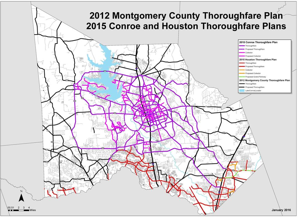
12 South County Mobility Plan Montgomery County Precinct 3 The Woodlands Township Shenandoah Oak Ridge North Texas Department of Transportation Woodlands Road Utility District #1 Montgomery County Thoroughfare Plan Montgomery County Conroe TxDOT
13 SCMP MCTP Planning horizon Short + Long Term Long Term Cost $500,000 $300,000 Specific Projects Yes No Project Cost Estimates Yes No Prioritized List of Projects Yes No Implementation Timeline Yes No Public Participation Yes Yes

14 Short Term Key Corridor Recommendations: 16 roadway projects on 9 roads for $207 M Short Term Other Recommendations: 15 roadway projects and 13 studies on 22 roads for $158 M (Includes IH 45 Study) 15 intersection, traffic management and bicycle improvement projects for $10 M Long Term Recommendations: 40 roadway projects on 24 roads for $1,208 M 14 bicycle/pedestrian corridors for $31M Thoroughfare Plan Updates East of I-45
15
16
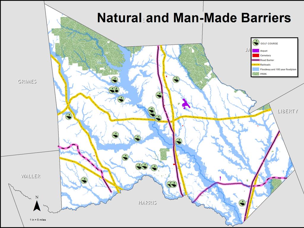
17 City and County thoroughfare plans The South County Mobility Plan Data Collection and Analysis Traffic congestion Traffic generators Man-made and natural barriers Input from focus groups, public meetings and elected officials

18 . 1979
19 .
20
21
22

23 Congestion Map FM 1488
24 Population and employment growth Lack of N/S and E/W roads across the county Congestion on IH 45; access to IH 69 and SH 99 Lack of roadway connectivity San Jacinto River Significant floodway and 100-year floodplain
25 SCMP Website Business Owners Open House Bicycle Focus Group Questionnaires/Comment Cards Elected Official Briefings Advertised Public Meetings: Shenandoah and Oak Ridge North MCTP Website Focus Groups: 10 July 2014 Data Gathering September 2015 Draft Thoroughfare Plan feedback Commissioners Court Briefings: 4 Advertised Public Meetings: Conroe, Shenandoah, New Caney and Magnolia


26 Recurring Comments Opposition to: extension of W. Tamina, Aldine- Westfield and Peoples Road Support for: Superior Road, Woodlands Parkway, Old Conroe Road, Magnolia loop/magnolia bypass, Loop around Conroe Need alternatives to IH 45 throughout the county Concern over the number San Jacinto River crossings


27 Issues addressed x x x x Opposition to thoroughfare through Cimarron Country Plan was modified Honea-Egypt was ended at Corrolla W. Tamina was not extended north Opposition to Aldine-Westfield extension via Scarlet Oak Trail Plan was not modified Aldine Westfield/Scarlet Oaks Trail is Major Thoroughfare (1979) Developer dedicated 100 of ROW to county
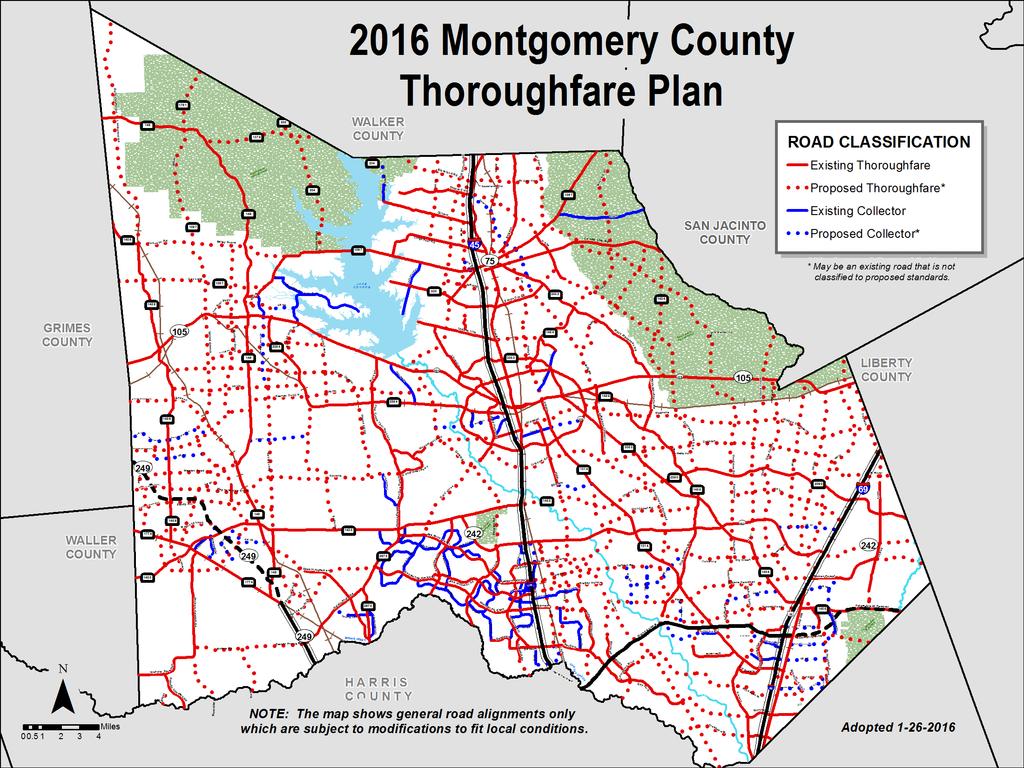
28

29

30

31
32 1. Woodlands Parkway Extension to SH 249 This corridor has been in the Montgomery County Thoroughfare Plan continuously since Branch Crossing Extension to FM 1488 This corridor is in the City of Conroe s Thoroughfare Plan and was carried forward to the MCTP. 3. Gosling Road Extension north of SH 242 toward the City of Conroe This proposal was in the South County Mobility Plan and Conroe s Thoroughfare Plan. This corridor has been in the Montgomery County Thoroughfare Plan since SCMP recommends further environmental impact assessment.
33 4. Grogan s Mill Extension to SH 242 Grogans Mill is not extended to SH 242 in either the SCMP or the MCTP. Grogans Mill merges into Vision Park which now ends at IH The expansion of Grogan s Mill Road south of Woodlands Parkway within the Township The MCTP is not a list of projects and has not recommend any road widening projects. It did identify Grogans Mill as a Major Thoroughfare, as does the City of Houston MTP. SCMP recommended the widening of Grogans Mill from Research Forest to Sawdust.
34 South County Mobility Plan Study completed: Sept Public Meeting for recommendations: September 2014 Document completed: Sept Plan accepted by Montgomery County, The Woodlands Township, Shenandoah, Oak Ridge North and WRUD#1: Sept.-Nov
35 Montgomery County Thoroughfare Plan: Thoroughfare Map: October 2015 Public Meetings on Thoroughfare Plan Map draft: Nov Commissioners Court action: January 26, 2016 Completion of plan documentation: June 2016


36 MontgomeryCountyMobility.com
Short and Long Term Needs
 Short and Long Term Needs The short- and long-term programs of proposed projects listed below have been designed to address the mobility issues in South Montgomery County. These improvements to the transportation
CHAPTER 1 INTRODUCTION
 CHAPTER 1 INTRODUCTION Chapter Table of Contents THE 2017 HOUSTON BIKE PLAN 1-1 HOUSTON BIKEWAYS PROGRAM 1-2 HISTORY OF BICYCLE PLANNING IN HOUSTON 1-3 BICYCLE LEVEL OF COMFORT 1-3 EXISTING PLANS, PROGRAMS
PLEASE BE ADVISED THAT SOME OF THE INFORMATION IN THIS PRESENTATION IS OUTDATED SO IT IS ABLE TO SHOW CHANGES IN THE PLAN OVER TIME.
 1 PLEASE BE ADVISED THAT SOME OF THE INFORMATION IN THIS PRESENTATION IS OUTDATED SO IT IS ABLE TO SHOW CHANGES IN THE PLAN OVER TIME. - SANDRA GREEN, CITY SECRETARY FARMERSVILLE CITY COUNCIL MEETING February
I-20 ODESSA-MIDLAND CORRIDOR STUDY. Public Meeting for Schematic Design
 I-20 ODESSA-MIDLAND CORRIDOR STUDY Public Meeting for Schematic Design The environmental review, consultation, and other actions required by applicable Federal environmental laws for this project are being,
Alamo RMA VRF Project Update June 2016
 Alamo RMA VRF Project Update June 2016 Vehicle Registration Fee In 2013, the 83 rd Texas Legislature enacted HB 1198 amending Section 502.402 of the Texas Transportation Code authorizing certain counties
Corpus Christi Metropolitan Transportation Plan Fiscal Year Introduction:
 Introduction: The Safe, Accountable, Flexible, Efficient Transportation Equity Act: A Legacy for Users (SAFETEA-LU) has continued the efforts started through the Intermodal Surface Transportation Efficiency
Best Southwest Transportation Committee. North Central Texas Council of Governments Transportation Department
 Best Southwest Transportation Committee North Central Texas Council of Governments Transportation Department The The Regional Regional Veloweb Veloweb Review Review NCTCOG Bicycle and Pedestrian Program
DRAFT KINGWOOD AREA MOBILITY STUDY
 DRAFT KINGWOOD AREA MOBILITY STUDY PREPARED FOR: PREPARED BY: MARCH 2015 Lake Houston Redevelopment Authority (TIRZ #10) 6161 Savoy, Suite 550 Houston, Texas 77036 Tel: 713.541.3530 www.gundacorp.com DRAFT
NEW BRAUNFELS SEGUIN AREA REGIONAL TRANSPORTATION DRAFT PLAN NEW BRAUNFELS CITY COUNCIL MEETING
 NEW BRAUNFELS SEGUIN AREA REGIONAL TRANSPORTATION DRAFT PLAN NEW BRAUNFELS CITY COUNCIL MEETING February 13, 2012 This regional transportation plan will: 1. Review existing plans for the cities and counties,
BASS PRO DRIVE TO: WEST OF FARM-TO-MARKET ROAD (FM)
") NOTICE OF PUBLIC MEETING INTERSTATE HIGHWAY 30 (Rockwall) FROM: BASS PRO DRIVE TO: WEST OF FARM-TO-MARKET ROAD (FM) 2642 CSJs: 0009-11-238; 0009-12-215; 0009-12-908 Dallas County and Rockwall County, Texas
NOTICE OF PUBLIC MEETING INTERSTATE HIGHWAY 30 (Rockwall) FROM: BASS PRO DRIVE TO: WEST OF FARM-TO-MARKET ROAD (FM) 2642 CSJs: 0009-11-238; 0009-12-215; 0009-12-908 Dallas County and Rockwall County, Texas
Access Management Conference
 Reduce motorist delay Signals Pedestrians Access Management Conference September, 2004 Safety Intersection Improvements Project Description FM 518 provides east-west mobility and access to many retail,
MONTGOMERY COUNTY, TEXAS AND INCORPORATED AREAS VOLUME 2 OF 6
 MONTGOMERY COUNTY, TEXAS AND INCORPORATED AREAS VOLUME 2 OF 6 COMMUNITY NAME COMMUNITY NUMBER CONROE, CITY OF 480484 CUT AND SHOOT, CITY OF 481279 HOUSTON, CITY OF 480296 MAGNOLIA, CITY OF 481261 MONTGOMERY,
Introduction...pg. 1. Study Area...pg. 1. Study Purpose and Need...pg. 2. Study Coordination and Development... pg. 3. Public Involvement...pg.
 Table of Contents Introduction...pg. 1 Study Area...pg. 1 Study Purpose and Need...pg. 2 Study Coordination and Development... pg. 3 Public Involvement...pg. 4 Evaluation of Alternatives...pg. 4 Preferred
Bike/Multipurpose Trail Study for Glynn County, Georgia MAY 16, 2016
 Bike/Multipurpose Trail Study for Glynn County, Georgia MAY 16, 2016 Agenda» Project Status Update» Draft Recommendations Overview» Next Steps» Questions/Discussion Project Overview» Comprehensive Bikeway
FM 471 PROJECT. OPEN HOUSE FM 471 (Culebra Road) from SH 211 to Old FM 471 Medina and Bexar Counties. FM 471 Project
 from SH 211 to Old FM 471 Medina and Bexar Counties. FM 471 Project") FM 471 PROJECT OPEN HOUSE FM 471 (Culebra Road) from SH 211 to Old FM 471 Medina and Bexar Counties January 24, 2018 Project Location 2 Proposed Improvements Improvements include: Expansion of FM 471 from
FM 471 PROJECT OPEN HOUSE FM 471 (Culebra Road) from SH 211 to Old FM 471 Medina and Bexar Counties January 24, 2018 Project Location 2 Proposed Improvements Improvements include: Expansion of FM 471 from
a 20 year period. separate phases of development with staggered years)
") Proposed: Approximately 2,000 acres located at along SH 130 at FM 973 Mixed Use project consisting of : Residential i Approximately 2,800 single family detached units Approximately 2,000 attached units
Proposed: Approximately 2,000 acres located at along SH 130 at FM 973 Mixed Use project consisting of : Residential i Approximately 2,800 single family detached units Approximately 2,000 attached units
ENERGY CORRIDOR DISTRICT UNIFIED TRANSPORTATION PLAN ACHIEVE MOBILITY THROUGH ENERGY
 ENERGY CORRIDOR DISTRICT UNIFIED TRANSPORTATION PLAN ACHIEVE MOBILITY THROUGH ENERGY energycorridor The Energy Corridor A Thriving Business Community 4 Located along Interstate between Kirkwood and Barker
APPENDIX G: INTERSECTION NEEDS AT OKEECHOBEE BOULEVARD
 APPENDIX G: INTERSECTION NEEDS AT OKEECHOBEE BOULEVARD INTERSECTION NEEDS AT SR 7 and OKEECHOBEE BOULEVARD SR 7 Extension Project Development and Environment (PD&E) Study From Okeechobee Boulevard (SR
Kingwood Area Mobility Study. Lake Houston Redevelopment Authority (TIRZ #10)
") Kingwood Area Mobility Study Lake Houston Redevelopment Authority (TIRZ #10) Steering Committee Meeting #3 Date: May 27, 2014 Introductions/Remarks Steering Committee Project/Consultant Team GOALS & MOE
Kingwood Area Mobility Study Lake Houston Redevelopment Authority (TIRZ #10) Steering Committee Meeting #3 Date: May 27, 2014 Introductions/Remarks Steering Committee Project/Consultant Team GOALS & MOE
DRAFT BUENA VISTA 2020 TRANSPORTATION PLAN
 DRAFT BUENA VISTA 2020 TRANSPORTATION PLAN DEVELOPED BY THE TRANSPORTATION PLANNING DIVISION OF THE VIRGINIA DEPARTMENT OF TRANSPORTATION IN COOPERATION WITH THE U.S. DEPARTMENT OF TRANSPORTATION, FEDERAL
2010 Pedestrian and Bicyclist Special Districts Study Update
 2010 Pedestrian and Bicyclist Special Districts Study Update Pedestrian and Bicyclist Special Districts Program Overview H-GAC s Special Districts Program aims to provide strategic investments in pedestrian
NORTH HOUSTON HIGHWAY IMPROVEMENT PROJECT DRAFT NEED AND PURPOSE
 NORTH HOUSTON HIGHWAY IMPROVEMENT PROJECT DRAFT NEED AND PURPOSE APPROVED BY FHWA: JULY 2010 UPDATED: OCTOBER 2011 Section 1 Need for and Purpose of Proposed Action Per Council on Environmental Quality
I-35 Corridor Segment Committee NW Loop 410 San Antonio, Texas. February 11, :00 AM to Noon
 I-35 Corridor Segment Committee 4 3500 NW Loop 410 San Antonio, Texas February 11, 2010 9:00 AM to Noon Welcome Nancy Parker Facilitator Committee Work Session Nancy Parker Facilitator Discussion of Proposed
5.0 Roadway System Plan
 Southwest Boise Transportation Study Page 16 5.0 Roadway System Plan The Roadway System Plan outlines roadway improvements in the Initial Study Area. It forecasts future deficiencies on the arterial system,
Hays County Transportation Plan. Commissioners Court Briefing January 15, 2013
 Commissioners Court Briefing January 15, 2013 Agenda for Today Work Groups Team members Advisory groups Challenges Public process Presentation of Thoroughfare Plan Map and Roadway Matrix Final steps Questions
Closing Plenary Session
 TRAFFIC SAFETY CONFERENCE Closing Plenary Session June 9, 2017 Las Colinas, TX Order of Report Out June 9, 2017 Las Colinas, TX Distracted Driving Prioritized Countermeasures Countermeasure 4a Systemically
State Highway 6 South
 Transportation Policy Council Accepted, January 2011 State Highway 6 South Corridor Access Management Plan In association with Klotz Associates Inc. The Lentz Group Gateway Planning CJ Hensch & Associates,
CITY MANUALS AND STANDARDS REVIEW
 GEORGETOWN SIDEWALK MASTER PLAN CITY MANUALS AND STANDARDS REVIEW RESOURCES AND STANDARDS As part of the Master Plan process, a review and evaluation of current City documents and policies relevant to
What if YOU could help plan Northern Virginia s transportation future?
 What if YOU could help plan Northern Virginia s transportation future? Photo credits: Washington Metropolitan Area Transit Authority And improve the quality of life in your community -- for yourself, your
City Council Briefing March 18, Draft Working Ideas for Confirmation of Direction
 City Council Briefing March 18, 2014 Draft Working Ideas for Confirmation of Direction Draft Working Ideas for Confirmation of Direction Overall Study Area Regional Population Growth Plan for Today and
MASTER THOROUGHFARE PLAN
 MASTER THOROUGHFARE PLAN Master Thoroughfare Plan Update November 2015 Prepared for Town of Northlake AVO 30659 11/11/2015 1201 North Bowser Road Richardson, Texas 75081 Firm Registration No. 312 MASTER
Tulsa Metropolitan Area LONG RANGE TRANSPORTATION PLAN
 Tulsa Metropolitan Area LONG RANGE TRANSPORTATION PLAN Indian Nations Council of Governments August 2005 CONTACTING INCOG In developing the Destination 2030 Long Range Transportation Plan, INCOG s Transportation
Highway 49, Highway 351 and Highway 91 Improvements Feasibility Study Craighead County
 Highway 49, Highway 351 and Highway 91 Improvements Feasibility Study Craighead County Executive Summary March 2015 Highway 49, Highway 351 and Highway 91 Improvements Feasibility Study Craighead County
SECTION 8 - INDUSTRIAL PROPERTY AERIAL PHOTOGRAPH: RED OAK INDUSTRIAL PROPERTY INFRASTRUCTURE IMPROVEMENTS (~530 ACRES)
") TABLE OF CONTENTS SECTION 1 - SUPERIOR LOCATION MAP: STATE OF TEXAS - RED OAK LOCATION DEPICTED AERIAL PHOTOGRAPH: NORTH CENTRAL TEXAS REGION - RED OAK LOCATION DEPICTED MAP: COUNTY OF ELLIS - RED OAK
TABLE OF CONTENTS SECTION 1 - SUPERIOR LOCATION MAP: STATE OF TEXAS - RED OAK LOCATION DEPICTED AERIAL PHOTOGRAPH: NORTH CENTRAL TEXAS REGION - RED OAK LOCATION DEPICTED MAP: COUNTY OF ELLIS - RED OAK
WELCOME. FM 2818 (Harvey Mitchell Parkway) Open House. Tuesday, Nov. 14, 2017
 Open House. Tuesday, Nov. 14, 2017") WELCOME FM 2818 (Harvey Mitchell Parkway) Open House Tuesday, Nov. 14, 2017 Why am I here? Review the planned improvements Provide comments on the proposed project The environmental review, consultation,
WELCOME FM 2818 (Harvey Mitchell Parkway) Open House Tuesday, Nov. 14, 2017 Why am I here? Review the planned improvements Provide comments on the proposed project The environmental review, consultation,
100 Most Congested Roadways in Texas
 100 Most Congested Roadways in Texas 2017 EXECUTIVE SUMMARY In response to increased roadway congestion throughout the state, in 2009 the Texas Legislature mandated that the Texas Department of Transportation
Bicycle Advisory Committee
 Bicycle Advisory Committee BAC Mission To advise and make recommendations to the commission and the director on issues related to bicycling in the city including, but not limited to, amendments to the
TABLE OF CONTENTS 7.0 THOROUGHFARE PLAN. Analysis of Future Conditions Thoroughfare Plan Proposed Cross-Sections.. 7.
 TABLE OF CONTENTS 7.0 THOROUGHFARE PLAN Analysis of Future Conditions.. 7.2 Thoroughfare Plan.. 7.3 Proposed Cross-Sections.. 7.4 Arterials Minor Arterials Collectors Local Streets Thoroughfare Plan Map
Hennepin County Bicycle and Pedestrian Planning
 Hennepin County Bicycle and Pedestrian Planning 1 Value of bicycle and sidewalk systems Safety Livability Mobility Health Personal Finances Economic Sustainability Clean Air Recreation Parking and congestion
FM 1092/Murphy Road Access Management Study Pulic Meeting #1. Wednesday, August 31, :00 p.m. 8:00 p.m.
 FM 1092/Murphy Road Access Management Study Pulic Meeting #1 Wednesday, August 31, 2011 6:00 p.m. 8:00 p.m. Introductions Agency Partners H-GAC Missouri City TxDOT Introductions Consulting Team In Association
Mobility Greater Johnson County Transportation Coalition. May 23, 2018
 Mobility 2045 Greater Johnson County Transportation Coalition May 23, 2018 Agenda Regional Perspective Mobility Planning Overview Mobility 2045 Draft Recommendations Financial Planning Overview Schedule
US 69 RELIEF ROUTE STUDY
 US 69 RELIEF ROUTE STUDY Jacksonville, Texas PUBLIC MEETING #2 May 29 th, 2018 Welcome to the public meeting for the US 69 Relief Route Study in Jacksonville. This is the second public meeting for this
Chapter 7. Transportation. Transportation Road Network Plan Transit Cyclists Pedestrians Multi-Use and Equestrian Trails
 Chapter 7 Transportation Transportation Road Network Plan Transit Cyclists Pedestrians Multi-Use and Equestrian Trails 7.1 TRANSPORTATION BACKGROUND The District of Maple Ridge faces a number of unique
Report Purpose To seek Council s approval of the Wye Road Functional Planning Study (January 2015).
.") COUNCIL MEETING Meeting Date: March 10, 2015 Agenda Item #: 13.1 Wye Road Functional Planning Study (January 2015) Report Purpose To seek Council s approval of the Wye Road Functional Planning Study (January
COUNCIL MEETING Meeting Date: March 10, 2015 Agenda Item #: 13.1 Wye Road Functional Planning Study (January 2015) Report Purpose To seek Council s approval of the Wye Road Functional Planning Study (January
Bicycle and Pedestrian Plans and Improvements
 Bicycle and Pedestrian Plans and Improvements Presented to the City Council By Randle Harwood, Planning and Development, and Richard Zavala, Parks and Community Services September 24, 2013 Purpose Review
PROJECT OVERVIEW. 20th Avenue Project Limits (Lincoln Way to Wawona St)
") PROJECT OVERVIEW In 2014, San Francisco adopted Vision Zero as City policy, with a commitment to eliminate all traffic deaths in the City by 2024. nue Project Limits (Lincoln Way to St) Collision data
PROJECT OVERVIEW In 2014, San Francisco adopted Vision Zero as City policy, with a commitment to eliminate all traffic deaths in the City by 2024. nue Project Limits (Lincoln Way to St) Collision data
AAMPO MOBILITY PROJECT DISCUSSION. July/August 2015
 AAMPO MOBILITY PROJECT DISCUSSION July/August 2015 Proposition 1 FY 16 & 17 $1.74 billion transferred to State Highway Fund in FY 2015 $147.3 million let in SAT district in FY 2015 US 90, IH 10, IH 410
100 Most Congested Roadways in Texas
 100 Most Congested Roadways in Texas 2018 Report EXECUTIVE SUMMARY In response to increased roadway congestion throughout the state, in 2009 the Texas Legislature mandated that the Texas Department of
Appendix C Status of Major Projects from the TIP
 Appendix C of Major Projects from the 2017-2020 TIP This page left blank intentionally of Major Projects Appendix C C 3 Appendix C of Major Projects from the 2017 2020 TIP Appendix C of the 2019-2022 Transportation
MASTER BICYCLE AND PEDESTRIAN PLAN
 WELCOME! PLEASE FEEL FREE TO REVIEW THE EXHIBITS THE PRESENTATION WILL BEGIN AT 6:00 PM VILLAGE OF NORTHBROOK MASTER BICYCLE AND PEDESTRIAN PLAN DRAFT EXISTING CONDITIONS REPORT AND PUBLIC MEETING WELCOME!
Frequently Asked Questions
 Frequently Asked Questions Business US 190 in Copperas Cove From Avenue D to Constitution Drive What is access management? A. Access Management is a growing effort by government agencies to improve how
State Highway 44/State Street High Capacity Corridor
 Background State Highway 44/State Street runs from I-84 in Canyon County through parts of the cities of Middleton, Star, Eagle, and Garden City to downtown Boise. It is a commuter route from several communities
DULLES AREA TRANSPORTATION ASSOCIATION (DATA) February 18, Susan Shaw, P.E., VDOT, Megaprojects Director
 February 18, Susan Shaw, P.E., VDOT, Megaprojects Director") DULLES AREA TRANSPORTATION ASSOCIATION (DATA) February 18, 2015 Susan Shaw, P.E., VDOT, Megaprojects Director I-66 Corridor Conditions Steady population growth Employment growth in activity centers Congestion
DULLES AREA TRANSPORTATION ASSOCIATION (DATA) February 18, 2015 Susan Shaw, P.E., VDOT, Megaprojects Director I-66 Corridor Conditions Steady population growth Employment growth in activity centers Congestion
SH 68. Meeting with Affected Property Owners September 9, 2014
 SH 68 Meeting with Affected Property Owners September 9, 2014 SH 68 US 83/I-2 TO US 281/I-69C Meeting with Affected Property Owners (MAPO) September 9, 2014 Agenda Open Meeting with Affected Property Owners
Montgomery Road Project Stakeholder Focus Group Meeting # 1 January 29, 2014
 Stakeholder Focus Group (SFG) Meeting #1: The first SFG meeting for the Montgomery Road Study was held on at the Montgomery Village Hall, 200 N. River Street, in Montgomery, Illinois from 2:00-4:00 PM.
JANUARY 2017 STUDY UPDATE. Logan City, Cache Co., CMPO
 JANUARY 2017 STUDY UPDATE Logan City, Cache Co., CMPO Purpose of the presentation To provide an update on the status of the Study To present the Study Purpose and Need To present the results of Level 1
RM 620 FEASIBILITY STUDY
 RM 620 FEASIBILITY STUDY Sections 5 & 6 December 7, 2015 STUDY PROCESS Study Purpose and Goals The RM 620 Feasibility Study was launched by the Texas Department of Transportation (TxDOT) to analyze transportation
Serving our local community since OAK RIDGE WOODLANDS AREA LITTLE LEAGUE
 Serving our local community since 1970. OAK RIDGE WOODLANDS AREA LITTLE LEAGUE ORWALL CORPORATE SPONSORSHIP PACKET -2018 Neighborhood Visibility for Your Business As our League Boundary Map shows, ORWALL
MULTIMODAL NEEDS ASSESSMENT
 1. ROADWAY INTRODUCTION The roadway network is the backbone of the region s transportation system. While Destino 2045 strives to establish a multi-modal transportation system, the roadway network is still
Municipal Class EA To Address Traffic Congestion On The Ontario Street Corridor (Grand Bend) Public Information Meeting June 4, 2018
 Public Information Meeting June 4, 2018") Municipal Class EA To Address Traffic Congestion On The Ontario Street Corridor (Grand Bend) Public Information Meeting June 4, 2018 Background Agenda Traffic Study Update Class EA Alternatives Bridge
Municipal Class EA To Address Traffic Congestion On The Ontario Street Corridor (Grand Bend) Public Information Meeting June 4, 2018 Background Agenda Traffic Study Update Class EA Alternatives Bridge
US 41 COMPLETE STREETS CORRIDOR PLANNING STUDY from University Parkway to Whitfield Avenue
 41 US 41 COMPLETE STREETS CORRIDOR PLANNING STUDY from University Parkway to Whitfield Avenue EXECUTIVE SUMMARY DRAFT FEBRUARY 2019 Project Overview The US 41 Complete Streets Corridor Planning Study,
3.0 Future Conditions
 3.0 Future Conditions In order to be able to recommend appropriate improvements to the transportation system of the Town, it is important to first understand the nature and volume of traffic that is expected
Multi Modal Transit Access Plan KIPDA ID # 239. Project Type: STUDY
 Multi Modal Transit Access Plan KIPDA ID # 239 Project Type: STUDY Description: In conjunction with the results from Project Gobility and the Transit LOS Analysis, TARC seeks to examine the possibilities
FM 471. Open House Public Meeting FM 471
 Open House Public Meeting November 12, 2014 FROM: LP 1604 TO: FM 3487 BEXAR COUNTY OPEN HOUSE PUBLIC MEETING November 12, 2014 H.B. Zachry Middle School 9410 Timber Pass 5:00 7:00 PM San Antonio, TX 78250
TRAFFIC ACTION PLAN. North Central Neighborhood CITY OF SAN MATEO
 TRAFFIC ACTION PLAN North Central Neighborhood CITY OF SAN MATEO Draft February 2017 Table of Contents Introduction... 1 The Traffic Forum Process... 4 Neighborhood Traffic Issues... 6 Neighborhood Recommendations
Welcome to Laredo Metropolitan Transportation Plan First Public Meeting. February 27 th, :30 PM to 7:30 PM. We value your opinion!
 Welcome to Laredo 2015-2040 Metropolitan Transportation Plan First Public Meeting February 27 th, 2014-5:30 PM to 7:30 PM We value your opinion! Todays Objectives Initiate the planning exercise for the
Uptown Houston November 2014
 Uptown Houston November 2014 City of Houston Leads the Nation in Job Growth Leads the Nation in Exports Record Construction Permits - $ 8 Billion Most Competitive Metro in America - Forbes New Development
WALKABLE + BIKEABLE REGIONS TxAPA Conference Alex Carroll Andrew Pompei, AICP Kelly Porter, AICP
 WALKABLE + BIKEABLE REGIONS 2016 TxAPA Conference Alex Carroll Andrew Pompei, AICP Kelly Porter, AICP How Metropolitan Areas Plan for Walking and Biking Alex Carroll APA Texas Chapter Planning Conference
Ujari Mohite. Vijay Mahal and Vincent Sanders. Revised Ridership Forecasts for the Uptown DBL project. Date: August 17, 2015 INTRODUCTION/SUMMARY:
 To: From: Subject: Ujari Mohite Vijay Mahal and Vincent Sanders Revised Ridership Forecasts for the Uptown DBL project Date: August 17, 2015 INTRODUCTION/SUMMARY: This memorandum presents updated ridership
Madison Urban Area and Dane County. Bicycle Transportation Plan Summary. September Introduction. Bicycle Plan Scope and Planning Process
 Bicycle Transportation Plan Summary Madison Urban Area and Dane County Introduction September 2000 Bicycling is an important mode of transportation in the Madison urban area and countywide that is available
CTH M HIGHWAY PROJECT CTH Q to STH 113
 CTH M HIGHWAY PROJECT CTH Q to STH 113 PUBLIC INFORMATIONAL MEETING #3 Wednesday, May 25, 2005 Town of Westport Administration Building 5387 Mary Lake Road 6:00 p.m. to 8:00 p.m. PUBLIC INFORMATIONAL MEETING
Commerce Street Complete Street Project from Good Latimer Expressway to Exposition Avenue
 Commerce Street Complete Street Project from Good Latimer Expressway to Exposition Avenue T A N Y A B R O O K S A S S I S T A N T D I R E C T O R M O B I L I T Y P L A N N I N G M O B I L I T Y A N D S
Board of Supervisors February 27, 2017
 : Traffic Analysis Results & Draft Conceptual Plan Board of Supervisors February 27, 2017 Transportation Solutions Building Better Communities Presentation Overview Background Summary of Traffic Analysis
US 1 Express Lanes Public Kick-Off Meeting
 US 1 Express Lanes Project Development & Environment (PD&E) Study Public Kick-Off Meeting September 7 & 8, 2011 Miami Dade County, Florida 1 Presentation Agenda Introduction to MDX Background to PD&E studies
WELCOME Public Information Centre
 WELCOME Public Information Centre Fernforest Drive Brampton Soccer Centre Community Room #2 Tuesday January 19, 2016 6:30 p.m.to 9:00 p.m. Please sign in Neighbourhood Traffic Calming Guide Background
PEDALING FORWARD. A Glance at the SFMTA s Bike Program for SFMTA.COM
 PEDALING FORWARD A Glance at the SFMTA s Bike Program for 2017-2021 SFMTA.COM INTRODUCTION About This Booklet More people from all walks of life see their bicycle as a more convenient way to get where
Route 29 Solutions Projects
 Route 29 Solutions Route 29 Solutions Projects www.route29solutions.org October 10, 2014 Route 29 Widening to Six Lanes Albemarle County This project will widen a 1.8-mile segment of Route 29 from four
4. ENVIRONMENTAL IMPACT ANALYSIS 9. TRANSPORTATION AND TRAFFIC
 4. ENVIRONMENTAL IMPACT ANALYSIS 9. TRANSPORTATION AND TRAFFIC 4.9.1 INTRODUCTION The following section addresses the Proposed Project s impact on transportation and traffic based on the Traffic Study
TRANSPORTATION MASTER PLAN Review Citywide Recommendations, Updated List and Scoring Methodology December 6, 2018
 NOTE: Due to lengthy Committee discussion and allotted meeting time, slides 12-35 were not presented at the meeting, but are provided here for reference. TRANSPORTATION MASTER PLAN Review Citywide Recommendations,
Chapter 5 Future Transportation
 Chapter 5 Future Transportation The Future Land Use Plan identifies the desired land use designations. The land uses desired for Crozet depend, in large part, on the success of the transportation system,
LOOP 360 IMPROVEMENT STUDY
 LOOP 360 IMPROVEMENT STUDY Overview and Preliminary Analysis August 2015 1 STUDY PROCESS 2 Study Background Loop 360 serves a wide range of users, including residents, businesses, bicyclists, and commuters
Proposed Project I 35 from Denton to Cooke County Line
 Proposed Project I 35 from Denton to Cooke County Line The existing I 35 facility is four lanes from I 35E/I 35W to Farm to Market Road (FM) 3002. The purpose of the proposed project is to increase capacity
IH 20 RANGER HILL PUBLIC MEETING
 IH 20 RANGER HILL PUBLIC MEETING AUGUST 25, 2015 IH 20, Eastland County, TX CSJ 0007-06-084 IH 20 from 3.5 mi. East of LP 254 to SH 16 (Ranger Hill) August 25, 2015 Agenda Introductions Purpose of the
Chapter 3.3 Horizon Elementary School. Volusia County MPO. June 2009
 Chapter 3.3 Horizon Elementary School Port Orange, FL Volusia County MPO June 2009 Volusia County MPO School Bicycle and Pedestrian Review Study, Phase 3C School Summary Horizon Elementary School is located
Figure 1: East West Connector Alignment Alternatives Concept Drawing
 Page 2 of 9 Figure 1: East West Connector Alignment Alternatives Concept Drawing The Montebello Drive extension will run north south and connect Wilsonville Road to the Boones Ferry Road to Brown Road
Thank you for attending
 Improving mobility safety comfort WELCOME Thank you for attending The purpose of this meeting is to: Learn about the project Prioritize potential walking and biking improvements on Snelling Ave Gather
2016 MOBILITY BOND PROGRAM
 February 22, 2017 2016 MOBILITY BOND PROGRAM $720 million bond proposition for transportation and mobility improvements including planning, designing, engineering, constructing, reconstructing, renovating
Complete Streets Policies in Charlotte
 Complete Streets Policies in Charlotte Complete Streets Peer Exchange Baton Rouge, LA January 19, 2016 Norm Steinman, AICP Charlotte DOT Changing what we do to change what will happen 1. Inventory of Conditions
Mineral Avenue Corridor Assessment. ITE 2017 Western District Annual Meeting San Diego, CA June 21 st
 Mineral Avenue Corridor Assessment ITE 2017 Western District Annual Meeting San Diego, CA June 21 st Biography - Aaron Heumann, PE, PTOE Currently City of Littleton Transportation Engineering Manager 24
MASTER BICYCLE AND PEDESTRIAN PLAN
 VILLAGE OF NORTHBROOK MASTER BICYCLE AND PEDESTRIAN PLAN DRAFT PLAN OPEN HOUSE May 2, 2018 AGENDA 1. Community Engagement 2. Vision and Goals 3. General Structure of Plan 4. Recommendations Overview 5.
STUDY ADVISORY COMMITTEE. October 8, 2015
 STUDY ADVISORY COMMITTEE October 8, 2015 Study Purpose evaluate the long-term transportation strategies and investments needed to sustain the county s economic health and quality of life in the coming
Arlington County 10-Year Transit Development Plan & Premium Transit Network Briefing. May 2016
 Arlington County 10-Year Transit Development Plan & Premium Transit Network Briefing May 2016 Overview 10-Year Transit Development Plan Premium Transit Network Columbia Pike service concept Premium amenities
University of Victoria Campus Cycling Plan Terms of Reference. 1.0 Project Description
 University of Victoria Campus Cycling Plan Terms of Reference 1.0 Project Description The Campus Cycling Plan, a first for the University, will provide a comprehensive and coordinated approach to support
WEST AND SOUTH WEST RING ROAD DOWNSTREAM TRAFFIC IMPACTS
 Page 1 of 9 EXECUTIVE SUMMARY Alberta Transportation ( AT ) is preparing to construct the final sections of the Calgary Ring Road. This includes the South West Ring Road ( SWRR ) (from Lott Creek Blvd
Public Event 1 Community Workshops
 Public Event 1 Community Workshops Nov. 24 & Dec. 3, 2016 Welcome Workshop Purpose We re looking to you for ideas and insights to help guide future transportation infrastructure planning in the Park Lawn
Bicycle Lanes Planning, Design, Funding South Mountain Partnership Trails Workshop Roy Gothie PennDOT Statewide Bicycle Pedestrian Coordinator
 Bicycle Lanes Planning, Design, Funding 2018 South Mountain Partnership Trails Workshop Roy Gothie PennDOT Statewide Bicycle Pedestrian Coordinator Policy Changes: BOP Bicycle Policy Changes The OLD Way
WELCOME. Thank you for joining us at the Second Public Workshop for the Carlsbad Pedestrian Master Plan. We look forward to receiving your feedback.
 City of Carlsbad Pedestrian Master Plan: WELCOME WELCOME Please Sign In Provide Input at Flip Charts Review Boards Presentation of Draft Plan Thank you for joining us at the Second Public Workshop for
RIDGE ROAD EXTENSION - PHASE I AND II (FROM RIDGE ROAD I DECUBELLIS ROAD I MOON LAKE ROAD INTERSECTION TO US 41)
") RIDGE ROAD EXTENSION - PHASE I AND II (FROM RIDGE ROAD I DECUBELLIS ROAD I MOON LAKE ROAD INTERSECTION TO US 41) ARMY CORPS OF ENGINEERS PERMIT APPLICATION SAJ-2011-00551 (IP-TEH) PASCO COUNTY ADDITIONAL
RIDGE ROAD EXTENSION - PHASE I AND II (FROM RIDGE ROAD I DECUBELLIS ROAD I MOON LAKE ROAD INTERSECTION TO US 41) ARMY CORPS OF ENGINEERS PERMIT APPLICATION SAJ-2011-00551 (IP-TEH) PASCO COUNTY ADDITIONAL
Staunton. Transportation Plan. Transportation Planning Division. Virginia Department of Transportation
 2020 Transportation Plan Developed for the Transportation Planning Division of the Virginia Department of Transportation in cooperation with the U.S. Department of Transportation, Federal Highway Administration
TRANSPORTATION COMMISSION Agenda Staff Report
 TRANSPORTATION COMMISSION Agenda Staff Report Agenda Item No. 5.a DATE: JULY 31, 2014 TO: FROM: SUBJECT: TRANSPORTATION COMMISSION COMMUNITY DEVELOPMENT DEPARTMENT - PLANNING DRAFT OLYMPIC CORRIDOR PREFERRED