Route 7/15 Norwalk. Route 7/15 Norwalk Project Project Advisory Committee Meeting #2. Tuesday, May 23 rd, Norwalk City Hall
|
|
|
- Camilla Sims
- 6 years ago
- Views:
Transcription

1 Project Project Advisory Committee Meeting #2 PAC Meeting #2 May 23, 2017 Tuesday, May 23 rd, Norwalk City Hall

2 - AGENDA Introductions PAC Meeting #1 Summary Overview of Traffic Conditions Bicycle and Pedestrian Update Draft Purpose and Need Context/Visual Assessments Design Visualization Next Steps/Questions


3 - FIRST MEETING RECAP 1. Reviewed PAC roles and responsibilities 2. Revisited project history and current status 3. Identified key important project issues 4. Viewed new interchange Alternative 26 (Signals)
4 - WHAT DID WE HEAR? Parkway Character Landscape and aesthetics Understanding topography/visualization tools Environmental/Cultural Separate Section 106/4(f) meeting Network Linkages How will signalization impact roadways? Safety and access to NRVT Bicycle and pedestrian improvements needed

5 OVERVIEW Route OF 7/15 TRAFFIC Norwalk CONDITIONS PAC Meeting #2 May 23, 2017

6 Traffic Study Area Four corridors US 7 CT 15 Main Avenue New Canaan Avenue
7 Traffic Study Area Four corridors US 7 CT 15 Main Avenue New Canaan Avenue
8 Traffic Study Area Four corridors US 7 CT 15 Main Avenue New Canaan Avenue
9 Traffic Study Area Four corridors US 7 CT 15 Main Avenue New Canaan Avenue

10 Core Traffic Study Area CT 15 interchanges with Route 7 and Main Avenue
 23")
11 - TRAFFIC CONDITIONS Traffic Data Collection Turning movement counts (Peak Period) 23 intersections

")
12 - TRAFFIC CONDITIONS Traffic Data Collection Automated traffic recorder counts (24 Hour) 29 locations


13 - TRAFFIC CONDITIONS Traffic Data Collection Travel time data collection (Peak Period) Study area corridors

14 - TRAFFIC CONDITIONS Peak Hour Traffic Volumes Main Ave: 2,000 vph Route 15: 5, vph Route 7: 4,500 vph
15 - TRAFFIC CONDITIONS Average Daily Traffic Volumes (ADT) Main Ave (south): 25,000 vpd Main Ave (north): 17,000 vpd Route 15: 55,000-72,000 vpd Route 7: 41,000-45,000 vpd
 Evaluating")

16 - TRAFFIC CONDITIONS Traffic Modeling and Analyses Three traffic models being used (Synchro, HCS, VISSIM) Evaluating conditions at 23 intersections, at 54 limited access highway segments along Route 7 and Route 15, and along study area corridors
17 - TRAFFIC CONDITIONS Traffic Modeling and Analyses How do we evaluate traffic operations? Travel Speed Travel Time Level of Service (LOS)

18 - TRAFFIC CONDITIONS Level of Service Classifications LOS A / LOS B Best qualities of service Traffic is at free flow with little to no restrictions on travel speed or overall mobility. There are no delays. LOS C / LOS D Acceptable qualities of service There are some restrictions in travel speed and mobility is a bit restricted. Delays are minimal/acceptable. LOS E / LOS F Failing or deficient Travel speeds decline significantly and mobility is severely restricted. Demand is greater than capacity. Delays are significant.

19 - TRAFFIC CONDITIONS Existing Level of Service

20 - TRAFFIC CONDITIONS Skycomp Aerial Origin-Destination (O-D) Study Understanding how people travel in, around, and through the study area Wednesday, September 21, AM-9AM, 11AM-1PM, 4PM-6PM


21 - TRAFFIC CONDITIONS Skycomp Aerial O-D Study Field of View +/- 21,000 photos analyzed over three peak periods

22 - TRAFFIC CONDITIONS Skycomp Aerial O-D Study Field of View +/- 21,000 photos analyzed over three peak periods

23 - TRAFFIC CONDITIONS Skycomp Aerial O-D Study Conditions at Main Ave / Route 15 Interchange Understanding mobility is just as important as understanding traffic demand 5:05PM
24 - TRAFFIC CONDITIONS NB US 7 Off-Ramp to New Canaan Ave (AM Peak Hour) Average travel time to NB CT 15: 5 minutes Almost 20% of vehicles have destinations within 1 mile of the Main Avenue/CT 15 interchange

25 - TRAFFIC CONDITIONS NB US 7 Off-Ramp to New Canaan Ave (PM Peak Hour) Average travel time to NB CT 15: 8 minutes 14% of vehicles have destinations within 1 mile of the Main Avenue/ CT 15 interchange
26 - TRAFFIC CONDITIONS SB CT 15 off-ramps to Main Avenue (AM Peak Hour) Average travel time to SB Route 7: 6 minutes 30% of vehicles destined to New Canaan Ave and points south

27 - TRAFFIC CONDITIONS SB CT 15 off-ramps to Main Avenue (PM Peak Hour) Average travel time to SB US 7: 7 minutes 18% of vehicles destined to New Canaan Ave and points south


28 - SAFETY ISSUES STOP Controlled on-ramps Short distances to enter/exit the Parkway


29 - SAFETY ISSUES Steep grades along the Parkway Main Ave / Creeping Hemlock Drive / Glover Ave intersection

30 - SAFETY ISSUES Merritt Parkway Crashes ( )

31 BICYCLE Route AND 7/15 PEDESTRIAN Norwalk


32 - BICYCLE AND PEDESTRIAN Main Avenue looking south from underneath Merritt Parkway Main Avenue looking north at Creeping Hemlock intersection Main Avenue looking towards Merritt 7
33 - BICYCLE AND PEDESTRIAN Assessing use and demand Coordination with NRVT and Norwalk Bike/Walk Task Force Pedestrian and bicyclist counts at intersections Strava - opt-in data recording focused more on recreation trips Journey to Work data Qualitative field observations

")
34 - BICYCLE AND PEDESTRIAN Bicycling (STRAVA) Running/Walking (STRAVA)

")
35 - BICYCLE AND PEDESTRIAN Bicycling (STRAVA) Running/Walking (STRAVA)

36 - BICYCLE AND PEDESTRIAN Norwalk Pedestrian and Bikeway Plan (2012)
37 DRAFT Route PURPOSE 7/15 Norwalk AND NEED


38 - DRAFT PURPOSE AND NEED Goals & Objectives Transportation Deficiencies Public and Agency Input Purpose and Need Statement

39 - DRAFT PURPOSE AND NEED What is Purpose & Need? 1. Defines the transportation problem 2. Limits range of alternatives- reasonable, prudent and practicable 3. Guides the alternatives analysis process 4. Clear, well-justified, specific and comprehensive P&N is the foundation for the selection of a course of action

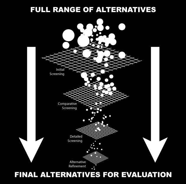
40 - ALTERNATE SCREENING

41 - DRAFT PROJECT PURPOSE Improve system linkage between Route 7 and the Merritt Parkway Improve the mobility for all users at the Merritt Parkway s Main Avenue and Route 7 Interchanges Improve safety in the vicinity of these interchanges

42 Ensure long-term serviceability of corridor Maximize public investment in corridor PAC Meeting #2 May 23, DRAFT GOALS & OBJECTIVES Ensure better interchange integration with environment and neighborhood context Provide for pedestrian and bicycle access
43 Discussion with PAC on general questions Open discussion on DRAFT text Interest in sub-committee to further refine? Next steps

44 CONTEXT/VISUAL ASSESSMENTS


45 - VISUAL CONTEXT Merritt Parkway Guidelines Merritt Parkway Landscape Master Plan Merritt Parkway Conservation and Restoration Plan: Bridge Restoration Guide Existing tree assessment and inventory
 Downtown Winnipauk, 1938.")
.")
46 - HISTORIC CONTEXT Intersection of the Merritt Parkway and Main Avenue (Route 7) Downtown Winnipauk, View northwest. (Bepler, Route 7 the Road North Norwalk to Canaan, p 18). Merritt Parkway intersection with Main Avenue, Google Maps.

 Merritt Parkway")
47 - HISTORIC CONTEXT Merritt Parkway intersection with Route 7, (Merritt Parkway Construction, Connecticut State Library, State Archives) Merritt Parkway intersection with Route 7, Google Maps.

48 DESIGN Route VISUALIZATION 7/15 Norwalk

49 - DESIGN VISUALIZATION Model Introduction NB Merritt Parkway Flyover (PM Peak)

50 - DESIGN VISUALIZATION Model Introduction NB Route 7 Flyover (PM Peak)


51 - DESIGN VISUALIZATION Model Comparison Main Avenue looking south from intersection with Creeping Hemlock Drive, Google Maps Main Avenue looking south from intersection with Creeping Hemlock Drive, RDV Visual Simulation.


52 - DESIGN VISUALIZATION Model Comparison Main Avenue looking northeast from Merritt View Building, Google Maps Main Avenue looking northeast from Merritt View Building, RDV Visual Simulation.

53 - DESIGN VISUALIZATION Interactive 3D Model Website

54 NEXT STEPS
55 - NEXT STEPS Continue development of existing conditions section of EA/EIE Continue to refine current alternates Refine visualization model Continue to meet with stakeholders Criteria prioritization exercise Historic working group (106 and 4(f)) PAC meeting in September Early fall scoping meeting

56 - NEXT PAC Meeting Review of scoping meeting Update on existing conditions work Modeling/simulation update Criteria ranking Review of alternates Other suggestions?

57 PAC Meeting #2 May 23, 2017
Hennepin/First Transportation Study
 CITY OF MINNEAPOLIS Hennepin/First Transportation Study NIEBNA Board Meeting November 10, 2016 11/10/2016 1 Study Overview Evaluate transportation system and alternatives Coordinate with County, Metro
Corridor Advisory Group and Task Force Meeting #10. July 27, 2011
 Corridor Advisory Group and Task Force Meeting #10 July 27, 2011 1 Agenda Recap CAG/TF #9 Public Meeting #2 Summary Single Mode Alternatives Evaluation Results Next Steps 2 3 CAG/TF #9 Recap CAG /TF #9
Appendix B: Forecasting and Traffic Operations Analysis Framework Document
 Existing Conditions Report - Appendix Appendix B: Forecasting and Traffic Operations Analysis Framework Document This document defines the methodology and assumptions that will be used in the traffic forecasting
General Plan Circulation Element Update Scoping Meeting April 16, 2014 Santa Ana Senior Center, 424 W. 3rd Street, Santa Ana, CA 92701
 General Plan Circulation Element Update Scoping Meeting April 16, 2014 Santa Ana Senior Center, 424 W. 3rd Street, Santa Ana, CA 92701 Meeting Agenda 1. Purpose of Scoping Meeting 2. Project Overview 3.
Subject: Solberg Avenue / I-229 Grade Separation: Traffic Analysis
 MEMORANDUM Transportation Bill Troe, AICP Jason Carbee, AICP 12120 Shamrock Plaza Suite 300 Omaha, NE 68154 (402) 334-8181 (402) 334-1984 (Fax) To: Project File Date: Subject: Solberg Avenue / I-229 Grade
Giles Run Connector Road
 Giles Run Connector Road Laurel Hill Adaptive Reuse Area to Laurel Crest Drive South County Federation Meeting June 14, 2016 History Connector road included in the Laurel Hill Comprehensive Plan amendment
TABLE OF CONTENTS. Executive Summary
 Executive Summary Background... ES-1 Pedestrian Network... ES-2 Bikeway Network... ES-2 Collision History... ES-2 Public Input... ES-4 Conclusions and Recommendations... ES-4 1. Introduction and Setting
MASTER BICYCLE AND PEDESTRIAN PLAN
 VILLAGE OF NORTHBROOK MASTER BICYCLE AND PEDESTRIAN PLAN DRAFT PLAN OPEN HOUSE May 2, 2018 AGENDA 1. Community Engagement 2. Vision and Goals 3. General Structure of Plan 4. Recommendations Overview 5.
Public Involvement Meeting Tuesday, June 13, Albany Shaker Road Corridor Study
 Public Involvement Meeting Tuesday, June 13, 2017 Albany Shaker Road Corridor Study Agenda / Meeting Outline 1. Introduce the project 2. Complete Streets 3. Share/confirm our findings 4. Your Opinion 5.
HARRISON STREET/OAKLAND AVENUE COMMUNITY TRANSPORTATION PLAN
 HARRISON STREET/OAKLAND AVENUE Community Workshop #4: Draft Plan Review December 3, 2009 D E S I G N, C O M M U N I T Y & E N V I R O N M E N T INTRODUCTIONS Key Project Staff: Alisa Shen, Project Manager,
APPENDIX F SUPPLEMENTAL TRAFFIC DATA
 APPENDIX F SUPPLEMENTAL TRAFFIC DATA Environmental and Planning Consultants 440 Park Avenue South 7th Floor New York, NY 10016 tel: 212 696-0670 fax: 212 213-3191 www.akrf.com Draft Memorandum To: Michael
Foothill Expressway Improvements Between El Monte and San Antonio
 Foothill Expressway Improvements Between El Monte and San Antonio June 29, 2017 - Los Altos Community Meeting Introduction Project Background Agenda Visit Stations: Provide Input and Ask Questions Reconvene:
Pedestrian, Bicycle and Traffic Calming Strategic Implementation Plan. January 18, 2011
 Pedestrian, Bicycle and Traffic Calming Strategic Implementation Plan January 18, 2011 Tonight s Agenda Receive update on project Provide feedback on two policy issues Complete Streets Policy Project Prioritization
Glenn Avenue Corridor Traffic Operational Evaluation
 Glenn Avenue Corridor Traffic Operational Evaluation PREPARED FOR: THE CITY OF AUBURN PREPARED BY: DECEMBER 2007 Glenn Avenue Corridor Study--Auburn, Alabama TABLE OF CONTENTS Introduction... 1 Background
Community Advisory Committee
 Community Advisory Committee Meeting #1 November 19, 2014 Presentation Team Matt Fulda, Greater Bridgeport Regional Council Chris Granatini, P.E., Tighe & Bond Craig Yannes, P.E., PE PTOE, Tighe & Bond
Regional Bicycle Barriers Study
 Regional Bicycle Barriers Study Executive Summary Background and Purpose The 2040 Transportation Policy Plan (TPP) sets policies for planning and investment direction in the transportation system in the
CITY OF SPOKANE VALLEY Request for Council Action
 CITY OF SPOKANE VALLEY Request for Council Action Meeting Date: December 16, 2014 Department Director Approval: Check all that apply: consent old business new business public hearing information admin.
Overview. Existing Conditions. Corridor Description. Assessment
 Overview A study of the 23 rd Street corridor was undertaken to document the existing conditions, analyze traffic operations, and recommend remedies for deficient situations Although 23 rd Street is frequently
MAG Town of Cave Creek Bike Study Task 6 Executive Summary and Regional Significance Report
 Page 1 MAG Town of Cave Creek Bike Study Task 6 Executive Summary and Regional Significance Report August 1, 2012 MAG Project #481 Page 2 Task 6 Executive Summary and Regional Significance Report Introduction
Intersection Control Evaluation Report Project: Alternative: Location: Evaluator:
 Report Project: Alternative: Location: Evaluator: Franklin/Interstate-15 Interchange City of Lake Elsinore, 33 40'13.08"N 117 18'34.30"W Jeffrey Hsu 1 Introduction Policy Directive 13-02 calls for the
MASTER BICYCLE AND PEDESTRIAN PLAN
 WELCOME! PLEASE FEEL FREE TO REVIEW THE EXHIBITS THE PRESENTATION WILL BEGIN AT 6:00 PM VILLAGE OF NORTHBROOK MASTER BICYCLE AND PEDESTRIAN PLAN DRAFT EXISTING CONDITIONS REPORT AND PUBLIC MEETING WELCOME!
Pedestrian Project List and Prioritization
 To: Kyle Wagenschutz, City of Memphis CC: From: Anne Conlon and John Cock, Alta Planning + Design Date: December, 2014 Re: Project List Development (Task 3.1-3.2) and Project List Prioritization (Task
Downtown Naples Mobility and Connectivity Study. Naples City Council Presentation January 2017
 Downtown Naples Mobility and Connectivity Study Naples City Council Presentation January 2017 Agenda 1. Introduction 2. Scope Review 3. Project Schedule 4. Existing Conditions 5. Public Charrette 6. Mobility
Route 7 Corridor Study
 Route 7 Corridor Study Executive Summary Study Area The following report analyzes a segment of the Virginia State Route 7 corridor. The corridor study area, spanning over 5 miles in length, is a multi
RETREAT AGENDA ITEM MIDTOWN AREA TRANSPORTATION PLAN UPDATE
 October 17, 2017 RETREAT AGENDA ITEM MIDTOWN AREA TRANSPORTATION PLAN UPDATE STATEMENT OF ISSUE An update on the Midtown Area Transportation Plan will be provided including a discussion of preliminary
Complete Streets Process and Case Study: Taft / McMillian Two-Way Street Conversion Cincinnati, Ohio. Traffic Engineering Workshop June 4, 2014
 Complete Streets Process and Case Study: Taft / McMillian Two-Way Street Conversion Cincinnati, Ohio Traffic Engineering Workshop June 4, 2014 Complete Streets Streets that enable safe access for users
City of Charlottesville Bicycle and Pedestrian Master Plan Update
 City of Charlottesville Bicycle and Pedestrian Master Plan Update September 17, 2014 I. Welcome and meeting overview II. Project status update III. Network overview IV. Break-out groups Pedestrian Network
Donahue Drive Corridor Traffic Operational Evaluation
 Donahue Drive Corridor Traffic Operational Evaluation PREPARED FOR: THE CITY OF AUBURN PREPARED BY: JANUARY 2007 Donahue Drive Corridor Study--Auburn, Alabama TABLE OF CONTENTS Introduction... 1 Background
Environmental Assessment Findings & Recommendations. Public Hearing November 13, 2014
 Environmental Assessment Findings & Recommendations Public Hearing November 13, 2014 Welcome! Welcome and Introductions Project and Environmental Assessment Overview Public Comments Adjourn Purpose of
BETHEL ROAD AND SEDGWICK ROAD CORRIDOR STUDY
 DRAFT PLAN City Council Meeting August 14, 2017 STUDY AREA Sedgwick Corridor State Route 160, principal arterial with Class 3 access management designation, commuter and freight route, connection to SR
Planning Study SR 976. Project Advisory Team Meeting May 24, 2017
 ` SR 976 BIRD ROAD/SW 40TH STREET FROM SR 821/HEFT TO SR 5/US-1 Miami-Dade County, Florida FPID No.: 434845-4-22-01 Planning Study Project Advisory Team Meeting May 24, 2017 1 Agenda Introductions Project
Northbound San Jose Avenue & I-280 Off-Ramp Road Diet Pilot Project
 Project Overview Fed by a two-lane Interstate-280 (I-280) off-ramp, high vehicular volumes and speeds are longstanding issues along San Jose Avenue. Residents in the surrounding neighborhoods have expressed
Project Report. South Kirkwood Road Traffic Study. Meadows Place, TX October 9, 2015
 Meadows Place, TX October 9, 2015 Contents 1 Introduction... 1 2 Data Collection... 1 3 Existing Roadway Network... 2 4 Traffic Volume Development... 2 5 Warrant Analysis... 3 6 Traffic Control Alternative
Road Conversion Study Plumas Street
 Plumas Street Phase I Submitted to The Regional Transportation Commission of Washoe County Submitted by Zong Tian, Ph.D., P.E. Saeedeh Farivar Haiyuan Li, Ph.D. Center for Advanced Transportation Education
Colchester/Riverside/Barrett/ Mill Intersection Study. PAC Meeting #3 September 22, 2016
 Colchester/Riverside/Barrett/ Mill Intersection Study PAC Meeting #3 September 22, 2016 Tonight s Agenda Review Project Purpose and Need Describe short term and long improvements and changes since public
ENHANCED PARKWAY STUDY: PHASE 2 CONTINUOUS FLOW INTERSECTIONS. Final Report
 Preparedby: ENHANCED PARKWAY STUDY: PHASE 2 CONTINUOUS FLOW INTERSECTIONS Final Report Prepared for Maricopa County Department of Transportation Prepared by TABLE OF CONTENTS Page EXECUTIVE SUMMARY ES-1
Chapter 4 Traffic Analysis
 Chapter 4 Traffic Analysis PURPOSE The traffic analysis component of the K-68 Corridor Management Plan incorporates information on the existing transportation network, such as traffic volumes and intersection
GIS Based Data Collection / Network Planning On a City Scale. Healthy Communities Active Transportation Workshop, Cleveland, Ohio May 10, 2011
 The Purpose of GIS Based Network Planning GIS Based Data Collection / Network Planning Healthy Communities Active Transportation Conference Tuesday, May 10, 2011 10:00 AM Norman Cox, LLA, ASLA. Ann Arbor,
WELCOME. Stakeholder Involvement Group Meeting #2 Round Lake Public Works October 24, 2018
 WELCOME Stakeholder Involvement Group Meeting #2 Round Lake Public Works October 24, 2018 MEETING AGENDA 1. Welcome and Introductions 2. Study Progress Update 3. Problem Statement 4. Technical Analysis
Dr. M.L. King, Jr. Street North Complete Streets Resurfacing Opportunities HOUSING, LAND USE, AND TRANSPORTATION COMMITTEE MARCH 22, 2018
 Dr. M.L. King, Jr. Street North Complete Streets Resurfacing Opportunities HOUSING, LAND USE, AND TRANSPORTATION COMMITTEE MARCH 22, 2018 What s Happening The City plans to mill and resurface Dr. M.L.
Highway 49, Highway 351 and Highway 91 Improvements Feasibility Study Craighead County
 Highway 49, Highway 351 and Highway 91 Improvements Feasibility Study Craighead County Executive Summary March 2015 Highway 49, Highway 351 and Highway 91 Improvements Feasibility Study Craighead County
Request for Authorization to Open Public Comment Period
 Request for Authorization to Open Public Comment Period May 12, 2015 LRP, TIPs, and Conformity Reasons for Requested Action: LRP and TIP Amendment to Connections 2040 LRP, and Draft FY 2016 TIP for New
Exhibit 1 PLANNING COMMISSION AGENDA ITEM
 Exhibit 1 PLANNING COMMISSION AGENDA ITEM Project Name: Grand Junction Circulation Plan Grand Junction Complete Streets Policy Applicant: City of Grand Junction Representative: David Thornton Address:
GIS Based Non-Motorized Transportation Planning APA Ohio Statewide Planning Conference. GIS Assisted Non-Motorized Transportation Planning
 The Purpose of GIS Assisted Network GIS Assisted Non-Motorized Transportation 2011 APA Ohio Statewide Conference Friday, 10:45 AM to Noon Focus on near-term projects wwwgreenwaycollabcom The purpose of
SH-6 Corridor Improvement Study Policy Committee Progress Report M O N D AY, J U N E 1 0, B R A Z O S C E N T E R
 SH-6 Corridor Improvement Study Policy Committee Progress Report M O N D AY, J U N E 1 0, 2 0 1 3 B R A Z O S C E N T E R Project Overview Study Goals and Objectives» Improve traffic flow» Reduce delay»
LOOP 360 IMPROVEMENT STUDY
 LOOP 360 IMPROVEMENT STUDY Overview and Preliminary Analysis August 2015 1 STUDY PROCESS 2 Study Background Loop 360 serves a wide range of users, including residents, businesses, bicyclists, and commuters
Public Meeting #1 January 30, 2018
 Public Meeting #1 January 30, 2018 Meeting Outline Mayor s Introduction Presentation Q&A Group Activities Wrap-up Presentation Outline Introduction Existing Conditions Market Assessment Break-out Setup
WALKNBIKE DRAFT PLAN NASHVILLE, TENNESSEE EXECUTIVE SUMMARY NASHVILLE, TENNESSEE
 NASHVILLE, TENNESSEE EXECUTIVE SUMMARY Executive Summary A world-class multi-modal transportation system is essential to a vibrant city and better quality of life. -Mayor Barry The WalknBike plan aims
POLICY ADVISORY COMMITTEE
 September 27, 2018 POLICY ADVISORY COMMITTEE ENVIRONMENTAL ANALYSIS PHASE Agenda 1. Welcome and introductions. 2. Overview of project activities and process. 3. Public engagement update. 4. Community Advisory
RURAL HIGHWAY SHOULDERS THAT ACCOMMODATE BICYCLE AND PEDESTRIAN USE (TxDOT Project ) June 7, Presented by: Karen Dixon, Ph.D., P.E.
 June 7, Presented by: Karen Dixon, Ph.D., P.E.") RURAL HIGHWAY SHOULDERS THAT ACCOMMODATE BICYCLE AND PEDESTRIAN USE (TxDOT Project 0-6840) June 7, 2016 Presented by: Karen Dixon, Ph.D., P.E., TTI Team: Kay Fitzpatrick, Raul Avelar, & Subasish Das Project
RURAL HIGHWAY SHOULDERS THAT ACCOMMODATE BICYCLE AND PEDESTRIAN USE (TxDOT Project 0-6840) June 7, 2016 Presented by: Karen Dixon, Ph.D., P.E., TTI Team: Kay Fitzpatrick, Raul Avelar, & Subasish Das Project
TRAFFIC STUDY GUIDELINES Clarksville Street Department
 TRAFFIC STUDY GUIDELINES Clarksville Street Department 9/1/2009 Introduction Traffic studies are used to help the city determine potential impacts to the operation of the surrounding roadway network. Two
4. ENVIRONMENTAL IMPACT ANALYSIS 9. TRANSPORTATION AND TRAFFIC
 4. ENVIRONMENTAL IMPACT ANALYSIS 9. TRANSPORTATION AND TRAFFIC 4.9.1 INTRODUCTION The following section addresses the Proposed Project s impact on transportation and traffic based on the Traffic Study
ADOT Statewide Bicycle and Pedestrian Program Summary of Phase IV Activities APPENDIX B PEDESTRIAN DEMAND INDEX
 ADOT Statewide Bicycle and Pedestrian Program Summary of Activities APPENDIX B PEDESTRIAN DEMAND INDEX May 24, 2009 Pedestrian Demand Index for State Highway Facilities Revised: May 29, 2007 Introduction
HYATTSVILLE TRANSPORTATION PLAN. City Council Update March 19, 2018
 HYATTSVILLE TRANSPORTATION PLAN City Council Update March 19, 2018 AGENDA PROJECT GOALS DATA COLLECTION WHAT WE LEARNED NEXT STEPS PROJECT GOALS Identify bicycle and pedestrian needs of the city Evaluate
TRAFFIC SIGNAL WARRANT STUDY
 TRAFFIC SIGNAL WARRANT STUDY 5 th STREET & ENCHANTED PINES DRIVE JANUARY 2013 TRAFFIC OPERATIONS ENGINEERING SERVICES/PUBLIC WORKS DEPARTMENT TABLE OF CONTENTS INTERSECTION LOCATION MAP ii INTRODUCTION
GARLAND ROAD/GASTON AVENUE/ GRAND AVENUE INTERSECTION IMPROVEMENT STUDY
 MEETING OF AFFECTED PROPERTY OWNERS AND STAKEHOLDERS GARLAND ROAD/GASTON AVENUE/ GRAND AVENUE INTERSECTION IMPROVEMENT STUDY CSJ 0009-02-067 Meeting Agenda 1 2 3 4 5 6 7 8 9 10 Opening Remarks State Representative
Commerce Street Complete Street Project from Good Latimer Expressway to Exposition Avenue
 Commerce Street Complete Street Project from Good Latimer Expressway to Exposition Avenue T A N Y A B R O O K S A S S I S T A N T D I R E C T O R M O B I L I T Y P L A N N I N G M O B I L I T Y A N D S
Elon Bicycle, Pedestrian and Lighting Plan. Pedestrian Rail Crossings Study
 Elon Bicycle, Pedestrian and Lighting Plan Pedestrian Rail Crossings Study Project Overview The Town of Elon, Elon University and the Twin Lakes Retirement Community began a comprehensive bicycle, pedestrian
I-105 Corridor Sustainability Study (CSS)
") I-105 Corridor Sustainability Study (CSS) Metro Streets and Freeways Subcommittee March 21, 2019 Gary Hamrick Cambridge Systematics, Inc. I-105 CSS Project History & Background Funded by Caltrans Sustainable
I-105 Corridor Sustainability Study (CSS) Metro Streets and Freeways Subcommittee March 21, 2019 Gary Hamrick Cambridge Systematics, Inc. I-105 CSS Project History & Background Funded by Caltrans Sustainable
Complete Streets Chicago: Data Driven Design. Luann Hamilton Deputy Commissioner
 Complete Streets Chicago: Data Driven Design Luann Hamilton Deputy Commissioner AGENDA Chicago s goals Complete Streets & Sustainable Infrastructure Guides Data-Driven Planning Setting goals Scoping/research
Welcome! San Jose Avenue Open House August 25, 2015
 Welcome! San Jose Avenue Open House August 25, 2015 Vision Zero The City and County of San Francisco adopted Vision Zero San Francisco Vision Zero High Injury Network as a policy in 2014, committing an
City of Davis East Covell Corridor Plan
 Community Open House #2 January 22, 2014 6:00 8:00 p.m. Veterans Memorial Center, Club Room City of Davis Introduction The (ECCP) is a taking a comprehensive look at the existing transportation systems
MoPac South: Impact on Cesar Chavez Street and the Downtown Network
 MoPac South: Impact on Cesar Chavez Street and the Downtown Network Prepared by: The University of Texas at Austin Center for Transportation Research Prepared for: Central Texas Regional Mobility Authority
PRELIMINARY DRAFT WADDLE ROAD / I-99 INTERCHANGE PROJECT ALTERNATIVE ANALYSIS FINAL TRAFFIC SUMMARY REPORT
 PRELIMINARY DRAFT WADDLE ROAD / I-99 INTERCHANGE PROJECT ALTERNATIVE ANALYSIS FINAL TRAFFIC SUMMARY REPORT Prepared by: In Association with: November 2013 EXECUTIVE SUMMARY Patton Township, in partnership
Waterford Lakes Small Area Study
 Waterford Lakes Small Area Study Existing Traffic Conditions PREPARED FOR: ORANGE COUNTY PUBLIC WORKS DEPARTMENT TRAFFIC ENGINEERING DIVISION ORLANDO, FLORIDA PREPARED WITH: INWOOD CONSULTING ENGINEERS
SANTA CLARA COUNTYWIDE BICYCLE PLAN August 2008
 SANTA CLARA COUNTYWIDE BICYCLE PLAN August 2008 To assist VTA and Member Agencies in the planning, development and programming of bicycle improvements in Santa Clara County. Vision Statement To establish,
5858 N COLLEGE, LLC N College Avenue Traffic Impact Study
 5858 N COLLEGE, LLC nue Traffic Impact Study August 22, 2016 Contents Traffic Impact Study Page Preparer Qualifications... 1 Introduction... 2 Existing Roadway Conditions... 5 Existing Traffic Conditions...
1609 E. FRANKLIN STREET HOTEL TRAFFIC IMPACT STUDY EXECUTIVE SUMMARY
 1609 E. FRANKLIN STREET HOTEL TRAFFIC IMPACT STUDY EXECUTIVE SUMMARY Prepared for: The Town of Chapel Hill Public Works Department Traffic Engineering Division Prepared by: HNTB North Carolina, PC 343
Complete Street Analysis of a Road Diet: Orange Grove Boulevard, Pasadena, CA
 Complete Street Analysis of a Road Diet: Orange Grove Boulevard, Pasadena, CA Aaron Elias, Bill Cisco Abstract As part of evaluating the feasibility of a road diet on Orange Grove Boulevard in Pasadena,
Fitting Light Rail through Well-established Communities
 Fitting Light Rail through Well-established Communities San Francisco 2008 Michael D. Madden Chief, Project Development, Maryland Transit Administration Project Setting Located inside the Capital Beltway
County Board Workshop
 CH 21 Downtown Reconstruction Project County Board Workshop Tuesday, October 24, 2017 CH 21 Downtown Prior Lake Reconstruction Agenda 1) Review remaining Project Alternatives 2) Public Engagement Summary
COMMUNITY MEETING #1 Summary
 COMMUNITY MEETING #1 Summary October 26, 2016 LOCATION: TIME: ATTENDEES: Dr. Phillips High School Cafeteria 6500 Turkey Lake Road, Orlando, FL 32819 6:00 pm to 8:00 pm 79 citizens Commissioner Scott Boyd,
SR 693 (Pasadena Avenue) Corridor Study from Shore Drive South to 66 th Street
 Corridor Study from Shore Drive South to 66 th Street") Welcome and Introduction Sign-in and comment sheets Restrooms and exits Meeting agenda and timeline Meeting goals / expectations Provide input to guide study recommendations Actively participate throughout
Welcome and Introduction Sign-in and comment sheets Restrooms and exits Meeting agenda and timeline Meeting goals / expectations Provide input to guide study recommendations Actively participate throughout
Lincoln Avenue Road Diet Trial
 Lincoln Avenue Road Diet Trial Data Collection Report June 1, 2015 Department of Transportation Table of Contents I. Introduction...... 3 II. Data Collection Methodology & Results...... 5 A. Traffic Volume
INTRODUCTION. The focus of this study is to reduce congestion and improve mobility for all modes of transportation. Figure ES-1 Study Corridor Map
 INTRODUCTION The I-280 Corridor Study is a highway planning study led by Santa Clara VTA, in partnership with the City of Cupertino and in coordination with other stakeholders in the study area. The study
NO BUILD TRAFFIC OPERATIONS
 3. 23 NO BUILD TRAFFIC OPERATIONS This section addresses the operations of the transportation system and details how it would be expected to function under year 23 No Build conditions with the projected
Rhode Island Moving Forward Long-Range Transportation Plan 2040 Municipal Roundtable Newport County
 Rhode Island Moving Forward Long-Range Transportation Plan 2040 Municipal Roundtable Newport County www.planri.com PlanRI2040@gmail.com Municipal Roundtable Meeting Summary Date/time: Location: Wednesday,
Connecting cyclists to work. Syracuse Metropolitan Transportation Council
 Connecting cyclists to work Syracuse Metropolitan Transportation Council Overview Prepared at request: NYS Department of Transportation (NYSDOT) Project Achievements Target group Purpose Process Recommendations
6.0 PEDESTRIAN AND BICYCLE FACILITIES 6.1 INTRODUCTION 6.2 BICYCLE DEMAND AND SUITABILITY Bicycle Demand
 6.0 PEDESTRIAN AND BICYCLE FACILITIES 6.1 INTRODUCTION Bicycle and pedestrian travel along and in the vicinity of the corridor is part of the vision of Somerset and Hunterdon counties and the integrated
Bicycle Master Plan Goals, Strategies, and Policies
 Bicycle Master Plan Goals, Strategies, and Policies Mobilizing 5 This chapter outlines the overarching goals, action statements, and action items Long Beach will take in order to achieve its vision of
Boston Post Road Design Feasibility Study
 Boston Post Road Design Feasibility Study Prepared for the City of Rye Final Report July 18, 2007 Prepared by: Buckhurst Fish & Jacquemart (BFJ) 115 Fifth Avenue New York, NY 10003 www.bfjplanning.com
David DiPierro, John Amberson. Steering Committee Meeting #4 Overview
 IBI GROUP 18401 Von Karman Avenue Suite 110 Irvine CA 92612 USA tel 949 833 5588 fax 949 833 5511 ibigroup.com Memorandum To/Attention Steering Committee Members Date February 17, 2016 From IBI Group Project
Traffic Impact Analysis Walton Acres at Riverwood Athletic Club Clayton, NC
 Traffic Impact Analysis Walton Acres at Riverwood Athletic Club Clayton, NC 1. TABLE OF CONTENTS INTRODUCTION...1 1.1. Site Location and Study Area...1 1.2. Proposed Land Use and Site Access...2 1.3.
February 2018 HIGHWAY 316 IMPROVEMENTS PROJECT
 February 2018 HIGHWAY 316 IMPROVEMENTS PROJECT Agenda 1 2 3 4 5 A Message from the City Project Area Traffic Conditions Pedestrian/Bicycle Comfort & Safety Next Steps Q&A City of Hastings Supports a study
TRANSPORTATION & MOBILITY
 TRANSPORTATION & MOBILITY ROADWAY SYSTEM There are approximately 40 miles of roadways in Manitou Springs. For planning purposes, roadways are typically assigned a functional classification which defines
Maryland State Highway Mobility Report. Morteza Tadayon
 Maryland State Highway Mobility Report Morteza Tadayon Background Mobility is a Key Performance Area (KPA) in the SHA Business Plan SHA adopts a performance based approach Monitors Highway System to identify
Virginia Street Bus RAPID Transit Extension Project. Environmental Assessment (EA) Presentation Public Hearing June 22, 2017
 Presentation Public Hearing June 22, 2017") Virginia Street Bus RAPID Transit Extension Project Environmental Assessment (EA) Presentation Public Hearing June 22, 2017 Presentation to RTC July 17, 2015 Presentation Overview Project Timeline Environmental
Virginia Street Bus RAPID Transit Extension Project Environmental Assessment (EA) Presentation Public Hearing June 22, 2017 Presentation to RTC July 17, 2015 Presentation Overview Project Timeline Environmental
CHAPTER 1 INTRODUCTION
 CHAPTER 1 INTRODUCTION Chapter Table of Contents THE 2017 HOUSTON BIKE PLAN 1-1 HOUSTON BIKEWAYS PROGRAM 1-2 HISTORY OF BICYCLE PLANNING IN HOUSTON 1-3 BICYCLE LEVEL OF COMFORT 1-3 EXISTING PLANS, PROGRAMS
Town of Bethlehem. Planning Assessment. Bethlehem Town Board
 Town of Bethlehem US 9W Corridor Transportation Planning Assessment Presented e to: Bethlehem Town Board June 2009 Overview Study Background Route 9W Corridor Conditions and Improvements Selkirk Bypass
FINAL DESIGN TRAFFIC TECHNICAL MEMORANDUM
 FINAL DESIGN TRAFFIC TECHNICAL MEMORANDUM July 2014 FINAL (SR 43) Project Development and Environment Study From State Road 60 (Adamo Drive) to I-4 (SR 400) Hillsborough County, Florida Work Program Item
US 69 RELIEF ROUTE STUDY
 US 69 RELIEF ROUTE STUDY Jacksonville, Texas PUBLIC MEETING #2 May 29 th, 2018 Welcome to the public meeting for the US 69 Relief Route Study in Jacksonville. This is the second public meeting for this
Bike/Multipurpose Trail Study for Glynn County, Georgia MAY 16, 2016
 Bike/Multipurpose Trail Study for Glynn County, Georgia MAY 16, 2016 Agenda» Project Status Update» Draft Recommendations Overview» Next Steps» Questions/Discussion Project Overview» Comprehensive Bikeway
Lyons Avenue/Dockweiler Road Extension Project Draft Environmental Impact Report. Appendix I Traffic Impact Study
 Lyons Avenue/Dockweiler Road Extension Project Draft Environmental Impact Report Appendix I Traffic Impact Study Street 0 80-1947 500.4501 RITA ld Court 0 91355-1096 400.7401 LA n Avenue 0 590-3745 300-9301
Transportation Impact Study for Abington Terrace
 Transportation Impact Study for Abington Terrace Abington Township, Montgomery County, PA Sandy A. Koza, P.E., PTOE PA PE License Number PE059911 Prepared by McMahon Associates, Inc. 425 Commerce Drive,
Owl Canyon Corridor Project Overview and Summary
 Owl Canyon Corridor Project Overview and Summary December 22, 2008 The Owl Canyon corridor (generally the connection between the I-25 / Larimer County Road 70 interchange and the US 287 / Larimer County
PROPOSED BICYCLE AND PEDESTRIAN FACILITY Vicinity of Route 123/I-495 Interchange Tysons, Fairfax County, Virginia
 PROPOSED BICYCLE AND PEDESTRIAN FACILITY Vicinity of Route 123/I-495 Interchange Tysons, Fairfax County, Virginia PRELIMINARY ENGINEERING REPORT Prepared for: Prepared by: July 2017 Table of Contents 1
You are invited to an... OPEN HOUSE. Recommended Approach for the Franklin Avenue / East River Parkway Intersection
 You are invited to an... OPEN HOUSE Recommended Approach for the Franklin Avenue / East River Parkway Intersection Tuesday, August 25, 2009 6:30 to 8:30 pm St. Frances Cabrini Catholic Church 1500 Franklin
Appendix C. Corridor Spacing Research
 Appendix C. Corridor Spacing Research Task 3 of the Twin Cities Bicycle Study called for the development of bicycle corridor spacing guidelines. This section summarizes research of the spacing of planned
Roosevelt Estates Neighborhood Improvements
 Roosevelt Estates Neighborhood Improvements Transportation Alternatives Application May 5 th, 2016 Qualifying Activities Construction of on-road and off-road trail facilities for pedestrians, bicyclists,
Welcome. Public Meeting. Heading 1. Heading 2. DeMers Ave. Columbia Rd. Washington St. 42nd St. 32nd Ave. Heading 3 HEADING
 Heading 1 Heading 2 Heading 3 HADING Welcome 4 Heading 5 Normal Normal Less Spacing Public Meeting Normal No Spacing Strong mphasis Intense mphasis To Do List ullet List ullet Last List ullet 2 CÞ List