Reference 10: Transportation
|
|
|
- Clarence Gibson
- 5 years ago
- Views:
Transcription
1 Reference 10: Transportation This information is intended to provide greater detail and background information on items described in the Transportation Chapter of the Comprehensive Plan. Items in the reference documents are not an adopted part of the Comprehensive Plan and are subject to change. Table of Contents Page Number R.10.3 Title and Description Transportation Acronyms Used in Comprehensive Plan Documents Provides a listing of common acronyms found and used throughout the Comprehensive Plan and associated documents. R.10.5 R.10.9 R R R Transportation Terms Used in Comprehensive Plan Documents Provides a listing a description of common terms found in and used throughout the Comprehensive Plan and associated documents. Key Transportation Planning Documents Used in Albemarle County Provides a description of the primary transportation planning documents and plans that have an impact on transportation policy and planning in Albemarle County. Federal Functional Classification of Public Roadways in Albemarle County Provides the functional classification of public roadways in Albemarle County used by VDOT in transportation planning. Example of Rural Traffic Calming Demonstration Project in Albemarle County Guidance on Traffic Calming and Safety Improvements on Rural Roads Provides an example of a private demonstration project plan utilizing rural traffic calming techniques. Prepared for the Route 22/ 231 Corridor in Keswick by the Piedmont Environmental Council in Ivy Road Design Study Provides guidance on improvements needed to Ivy Road and Old Ivy Road. Adopted by the Planning and Advisory Council (PACC) in Formatted: Underline R.10.1
2 Page intentionally left blank. Formatted: Centered R.10.2
3 Transportation Acronyms Used in Comprehensive Plan Documents The following transportation-related acronyms are used in the Transportation Chapter: 3-C Continuing, Cooperative, and Comprehensive planning process AADT Annual Average Daily Traffic BRT Bus Rapid Transit CA-MPO Charlottesville-Albemarle Metropolitan Planning Organization CAT Charlottesville Area Transit (Formerly Charlottesville Transit Service or CTS) CHART Charlottesville-Albemarle Regional Transportation Committee CIP Capital Improvement Program (Albemarle County) CoSS Corridor of Statewide Significance CTB Commonwealth Transportation Board DPRT Virginia Department of Rail and Public Transportation FHWA Federal Highway Administration FTA Federal Transit Administration FY Fiscal Year (refers to the state fiscal year July 1 June 30) LRSTP Long Range State-wide Transportation Plan (VTrans 2035) LRTP Long Range Transportation Plan (UnJam 2035) MAP-21 Moving Ahead for Progress in the 21st Century Act MOU Memorandum of Understanding MPO Metropolitan Planning Organization NHS The National Highway System (NHS) RLRP Rural Long Range Transportation Plan (outside of the MPO area) RTA Regional Transit Authority SAFETEA-LU Safe, Accountable, Flexible, Efficient Transportation Equity Act: Act: A Legacy for Users SYIP Six Year Improvement Plan TAZ Traffic Analysis Zone TDP Transit Development Plan (for CAT and JAUNT) TDM Travel Demand Management TIP Transportation Improvement Program TJPDC Thomas Jefferson Planning District Commission UPWP Unified Planning Work Program (also referred to as Work Program) UTS University Transit Service UVA University of Virginia VDOT Virginia Department of Transportation VMT Vehicle Miles Traveled VSTP Virginia Surface Transportation Plan Source: Albemarle County, TJPDC, VDOT R.10.3
4 Page intentionally left blank. Formatted: Centered R.10.4
5 Transportation Terms Used in Comprehensive Plan Documents The following transportation-related terms are commonly used in the Transportation Chapter: Access Management: The systematic control of the location, spacing, design, and operation of entrances, median openings/crossovers, traffic signals, and interchanges for the purpose of providing vehicular access to land development in a manner that preserves the safety and efficiency of the transportation system. Arterial: A major highway intended to serve through traffic where access is carefully controlled, generally highways of regional importance, intended to serve moderate to high volumes of traffic traveling relatively long distances and at higher speeds. A Principal Arterials are major highways intended to serve through traffic where access is carefully controlled, generally highways of regional importance, with moderate to high volumes of traffic traveling relatively long distances and at higher speeds. Minor Arterials are highways that interconnect with and augment the principal arterial system. Minor arterials distribute traffic to smaller geographic areas providing service between and within communities. Collector: The functional classification of a highway that provides land access service and traffic circulation within residential, commercial, and industrial areas. The collector system distributes trips from principal and minor arterials through the area to the ultimate destination. Conversely, collectors also collect traffic from local streets in residential neighborhoods and channel it into the arterial system. Collectors can be major or minor. Commonwealth Transportation Board CTB): Virginia s Secretary of Transportation works with the Governor to develop an overall transportation budget and to identify strategies for generating and managing transportation funds. The CTB, oversees the development of the State s long-range transportation plan, VTrans2035 and uses it as a policy guide for statewide transportation planning and decision-making. The CTB s key decision-making responsibility is to allocate (or program ) available funds to transportation projects across the Commonwealth, chiefly through the annually updated Six-Year Transportation Improvement Program (SYIP). Complete street: A complete street is one that is designed and operated in manner that enables safe access for all users, creating multimodal transportation networks. Complete streets make it easier to cross the street, walk to shops, and bicycle to work. Roads in the Development Areas are expected to be complete streets that can accommodate and encourage pedestrians, bicyclists, and transit, in addition to cars. Federal Highway Administration (FHWA): A branch of the U.S. Department of Transportation that administers the federal-aid highway program, providing financial assistance to states to construct and improve highways, urban and rural roads, and bridges. The FHWA also administers the Federal Lands Highway Program, including survey, design, and construction of forest highway system roads, parkways and park roads, Indian reservation roads, defense access roads, and other Federal Lands roads. Federal Transit Administration (FTA): A branch of the U.S. Department of Transportation that administers federal funding to transportation authorities, local governments, and states to support a variety of locally planned, constructed, and operated public transportation systems throughout the U.S., including buses, R.10.5
6 subways, light rail, commuter rail, streetcars, monorail, passenger ferry boats, inclined railways, and people movers. Fiscal Constraint: Making sure that a given program or project can reasonably expect to receive funding within the time allotted for its implementation. Functional Classification: The federal system of classifying groups of highways according to the character of service they are intended to provide and classifications made by the VDOT Commissioner based on the operational characteristics of a highway. Each highway is assigned a functional classification based on the highway s intended purpose of providing priority to through traffic movement or adjoining property access. The functional classification system groups highways into three basic categories identified as (1) arterial, with the function to provide through movement of traffic; (2) collector, with the function of supplying a combination of through movement and access to property; and (3) local, with the function of providing access to property. Interstates are principle arterials. Highway, street, or road: means a public way for purposes of vehicular travel, including the entire area within the right-of-way. Interstates: four to ten lane highways that connect states and major cities. Interstates have the functional classification of principle arterial. JAUNT, Inc.: Regional transit service provider to Charlottesville City, and Albemarle, Fluvanna, Louisa, Nelson, Buckingham, Greene and Orange Counties. Originally stood for Jefferson Area United Transportation, since 1982 JAUNT, Inc. has been the legal name not just an acronym. Long Range Transportation Plan: MPO area, currently known as the 2035 UnJAM Plan, the updated plan will be called LRTP Local streets/roads: Is the functional classification for highways that comprise all facilities that are not collectors or arterials. Local streets serve primarily to provide direct access to abutting land and to other streets. Metropolitan Planning Organization (MPO): Charlottesville-Albemarle MPO is one of fourteen state MPOs that facilitate coordinated planning and programming of transportation projects in urban regions, particularly federally funded facilities. Moving Ahead for Progress in the 21st Century Act (MAP-21): (legislation that governs the metropolitan planning process) funds Federal surface transportation programs for FY 2013 and replaced SAFETEA-LU. In July 2012, Congress passed a Federal Transportation Act to update SAFETEA-LU. The 2012 update, MAP-21, carries forward the key planning requirements and provisions of SAFETEA-LU with an added emphasis on performance-based planning and programming. National Highway System (NHS): The National Highway System (NHS) consists of roadways important to the nation's economy, defense, and mobility. Principal Arterials are part of the National Highway System. Planning District Commission (PDC): Thomas Jefferson PDC is one of twenty-one PDCs throughout Virginia that provide sponsored transportation planning services in Virginia s rural regions and small urban areas. PDCs also provide a unique forum for coordinating multi-disciplinary regional plans that address economic, environmental, and social issues. VDOT and DRPT work actively with MPOs and PDCs on an individual basis and through statewide associations such as VAMPO and VAPDC. R.10.6
7 Primary roads: State road classification for two to six lane roads that connect cities and towns with each other and with interstates. Generally routes numbered under 600. Rideshare: Travel Demand Management (TDM) services housed at TJPDC that promote congestion relief and air quality improvement through carpool matching, vanpool formation, Guaranteed Ride Home, employer outreach, telework consulting and multimedia marketing programs for the City of Charlottesville, and Albemarle, Fluvanna, Louisa, Nelson, and Greene Counties Roadway: The portion of a highway, including shoulders, for vehicular use. A divided highway has two or more roadways. Rural Area: The areas outside the boundaries of urbanized areas and urban places (see Urban Area). The Charlottesville-Albemarle MPO is an urbanized area with a population of over 50,000. Therefore, the land area in Albemarle County not within the MPO Urban Area is in the Rural Area. This Rural Area is not the same Albemarle County s Comprehensive Plan Rural Areas. The County s Rural Area boundaries and non-urban area boundaries cover much of the same area but are not exactly the same. Safe, Accountable, Flexible, Efficient Transportation Equity Act (SAFETEA-LU): A Legacy for Users Funded Federal surface transportation programs from Replaced and built upon the Intermodal Surface Transportation Efficiency Act of 1991 (ISTEA) and the Transportation Equity Act for the 21 st Century (TEA-21). SAFETEA-LU was replaced by MAP-21 in July Secondary roads: State road classification for state maintained roads with routes numbered 600 and above. Secondary roads are owned by localities but maintained by VDOT. Secondary roads are the majority of roadways in the Rural Areas. Travel Demand Management (TDM): also known as transportation demand management, TDM is the application of strategies and policies to reduce travel demand by reducing the emphasis on singleoccupant vehicles or redistributing transportation demand in space or time. Unified Planning Work Program (UPWP): A statement of work identifying the planning priorities and activities to be carried out within the MPO. At a minimum, a UPWP includes a description of the planning work and resulting products, who will perform the work, time frames for completing the work, the cost of the work, and the source(s) of funds. Urban Area: For MPO planning purposes, an urban area is either an urbanized area (population of 50,000 and over), or an urban place as designated by the Bureau of the Census (population of 5,000 or more) and not within any urbanized area, with boundaries fixed by State and local officials and approved by the Federal Highway Administration. The Charlottesville-Albemarle MPO is an urbanized area with a population of over 50,000. This Urban Area is not the same Albemarle County s Comprehensive Plan Development Area boundaries. The County s Development Area boundaries and the MPO Urban Area boundaries cover much of the same area but are not exactly the same. R.10.7
8 Page intentionally left blank. Formatted: Centered Formatted: Font: Italic R.10.8
9 R.10.9
10 Key Statewide, Regional and Local Transportation Planning Documents National General Title National Surface Transportation Program Current Plan Title MAP-21 FY Who Develops/ Approves? U.S. DOT/ Congress & President Coverage Nationwide Span/ Updated? 2 years /As needed Contains National surface transportation funding for highways, transit, bike and ped. programs State Regional Local State Transportation Improvement Program (STIP) Long-Range Statewide Transportation Plan (LRSTP) Unified Planning Work Program (UPWP) Rural Transportation Planning Work Program Transportation Improvement Program (TIP) Six Year Improvements Program (SYIP) Long Range Transportation Plan (LRTP) Rural Long Range Plan (RLRP) Secondary Six-Year Plan (SSYP) County Comprehensive Plan Development Area (DA) Master Plans Virginia STIP FY VDOT / U.S. DOT Statewide 4 years / every 5 years VTRANS 2035 VDOT / CTB Statewide 20 years / every 5 years Charlottesville-Albemarle Metropolitan Planning Organization UPWP FY-2014 TJPDC Rural Transportation Planning Work Program Charlottesville- Albemarle TIP FY Albemarle County FY SYIP Statewide transportation investments Statewide future goals, strategies and projects MPO/ MPO MPO Area 1 year / annually MPO Area Transportation Planning studies and tasks TJPDC/ TJPDC Rural areas of TJPDC region MPO/ MPO MPO Area 4 years / every 4 years BOS/ VDOT VDOT Culpeper District UnJAM 2035 MPO/ MPO MPO Area 20 years / every 5 years TJPDC 2035 Rural Long- TJPDC/ TJPDC Rural area 20 years / every Range Transportation Plan of the TJPDC 5 years Albemarle County FY SSYP Transportation Section of Future Land Use Plan Transportation section of Individual Master Plans BOS / VDOT Planning Commission/ BOS Planning Commission/ BOS region Albemarle County Albemarle County Each DA in the County 1 year / annually Rural areas transportation Planning studies and tasks Schedules spending on federal transportation funds (with state and local funds as well) 5 years/ annually Primary roads and Interstates, bike, ped. and transit projects 5 years / Annually 20 years / every 5 years 20 years / every 5 years MPO area s future goals, strategies and projects Rural areas future goals, strategies and projects VDOT s Secondary road and bridge construction program based upon County s Priority List. Local (countywide) transportation goals, objectives and strategies Individual DA transportation goals, objectives and strategies R.10.10
11 Sources: Albemarle County, TJPDC, VDOT, FHWA Page intentionally left blank. Formatted: Centered Formatted: Font: Italic R.10.11
12 R.10.12
13 Functional Classification System of Roadways in Albemarle County Formatted: Left, Adjust space between Latin and Asian text, Adjust space between Asian text and numbers The three main functional categories of County roadways are arterial, collector, and local. Arterial roadways are divided into the sub-categories of principal and minor arterials. The Federal Highway Administration (FHWA) further defines principal arterials as roadways classified as interstates, other freeways and expressways, and other principal arterials. All Principal Arterials are included in the National Highway System of Roads. Collector roadways are divided into sub-categories of major and minor collectors. VDOT is currently in the process of updating the functional classification of roadways throughout the State as is done following a decennial census and, in this case, in response to new Federal Highway Administration (FHWA) guidance for the functional classification system. Maps showing the updated Functional Classifications will be available in late The highest functional class of roadway in Albemarle County is the principal arterial. Interstate 64 is classified as a principal arterial and part of the National Highway System. I-64 traverses the County and connects the Charlottesville-Albemarle County region to major north-south interstates (I-81 and 1-95) and the Richmond and Norfolk metropolitan areas. Interstate highways are the highest level of functional road and are part of a national system of freeways and expressways, providing long distance traffic, high speed and limited access connections. I-64 has seven gradeseparated interchanges in the County at Route 616 (Exit 126), Route 250 (Exit 124), Route 20 (Exit 121), 5 th Street Extended (Exit 120), and Routes 20/250 (Exit 118), Route 637 (Exit 114) and Route 250 (Exit 107). Three of the interchanges are located in the County s Development Areas Exits 118, 120 and 121 and are addressed in the Master Plan for the Southern and Western Neighborhoods. The remaining four interchanges are in the Rural Area and are discussed in greater depth in the Rural Area Section of the Plan. VDOT maintains a safety rest area along eastbound I-64 (at mile marker 105). Other principal arterials include Route 29 and Route 250 from I-64 west to Route 29. The County is connected to the Interstate by way of the arterial and collector roadway network that runs through the County. Updates to the roadway functional classifications will be available once the updated functional classification maps are adopted by the Commonwealth Transportation Board in late R.10.13
14 Page intentionally left blank. Formatted: Centered Formatted: Font: Italic R.10.14
15 R.10.15

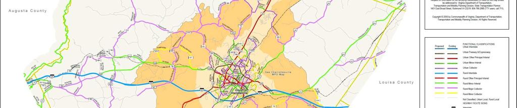
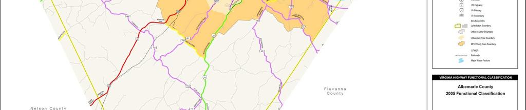
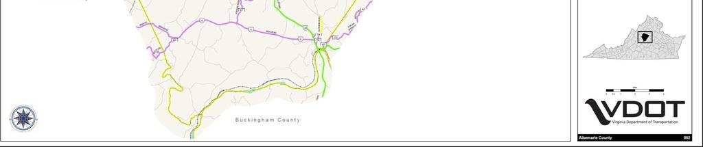
16 R VDOT Functional Classification Map
17 R.10.17
18 R.10.18
19 R.10.19
20 R.10.20
21 R.10.21
22 R.10.22
23 R.10.23
24 R.10.24
25 R.10.25

26 R Formatted: Left: 1", Right: 1", Top: 0.69", Bottom: 0.69", Width: 11", Height: 8.5"
27 IVY ROAD DESIGN STUDY The Ivy Road Design Study may be found at the website below: A printed copy of this plan may be reviewed in the Department of Community Development. A subsequent memorandum related to this study is provided on the following page. R.10.27
28 Ivy Road Improvement Study: PACC Report May 2008 BACKGROUND In 1994 the City, County and University jointly sponsored a design study of Ivy Road. The consultants who prepared the study were Lardner Klein (LK) Landscape Architects P.C. of Alexandria, Virginia. The introduction to the report states: Ivy Road (Route 250 West) is a front door to Charlottesville, Albemarle County, and the University of Virginia. As such, its appearance is second only in importance to its safety.as one of the primary entrances to the City, the County and the University, Ivy Road s appearance and its function is a strong determinant of the general public s perception of the area. Thirteen years later, this description is no less true, although the University has implemented the recommended improvements along two borders of its property on Ivy Road. Since then, the City and County have included the implementation of the proposed improvements road widening, bicycle lanes, sidewalks and plantings in their requests to VDOT for funding through the regional Transportation Improvement Plan (TIP) but the annual road funding allocations have to date been insufficient to accomplish the project. PACC proposes to study an alternate approach to funding by submitting a joint project request to the Commonwealth s Revenue Sharing Program. Proposed Improvements The 1994 Study included proposals for bike lanes, continuous sidewalks, relocated utility wires, pedestrian scale street lighting, a raised planted median and other plantings, sign guidelines, and consistent street furnishing. The Study also called for road widening in certain areas; however, the thrust of this new initiative is related to alternative models of transit: bus, bike and pedestrian. Pedestrian safety in the corridor has become more important since the construction of the Ivy-Emmet garage and the JPJ Arena. It is also expected that the $100 million Arts Gateway to the University (currently in design) will attract more bicycles, transit users and pedestrians to this corridor. The University has also completed a more recent study to address current conditions at the Ivy-Emmet intersection. It is anticipated that the recommendations of that study will be included in the scope of the proposed joint project. Revenue Sharing Program VDOT administers a $50 m. program that provides additional funding for use by a county, city, or town to construct, maintain or improve the highway system by providing state funds to match local contributions for small, immediately needed improvements. Sidewalks and trails are eligible for this funding in the Incidental improvements category; however the focus of the program is to improve the highway system. The Commonwealth Transportation Board (CTB) allocates project funding based on a tiered priority system. At least 50% match up to $1 million maximum state contribution per locality. Highest priority is given to projects where the locality is giving more than $1 million for a $1 million match (more than 50%). Projects may be administered locally or by VDOT. Application must be submitted by the locality but 50% of match can be provided by other sources. Therefore if the City, County, and University each contributed $1 million, the state conceivably could match that with $2 million, if the terms of the program are not altered in the upcoming legislative session, providing $5 million in total project funding for improvements to this important entrance corridor. STUDY PROCESS The Study Group (participants noted below) met on February 28 th, 2008 at UVA to discuss the process of preparing for an action plan and report to PACC in The objectives were to develop a proposal for state funding, improve multi-modal accessibility, and expand a collaborative approach to ongoing maintenance and improvements. The steps included: Participants reviewed Lardner Study and other associated studies such as the 1989 Lewis Mountain University Heights Area B Study, and the 2005 Ivy Emmet Intersection Area Study by Kimley-Horn. R.10.28
29 Participants recorded recommendations made in plan, those that had been completed, and the recommendations that were no longer relevant per the City, County and University. Participants reviewed potential funding sources in addition to the revenue sharing program. The findings of this study process are presented on the following pages. In general, the majority of recommendations from the study have not been completed due to a lack of prioritization, funding, and the relatively minor amount of development that has occurred along the corridor since However, the study process was very useful to inform current staff of the recommendations and highlight the need to improve this important Entrance Corridor to our community. The City and County currently have established priorities for the near-term use of the Commonwealth s Revenue Sharing Program, so use of this sharing program to support the Ivy Corridor would be a long term goal unless the City and County are willing to reconsider their priorities. Other programs could also be assessed for their potential to help support improvements, such as an assessment district, or through the Governor s recent order on Sustainable Community Investment. PACC should make recommendations as to appropriate funding mechanisms for this community investment. Participants: City Jeanie Alexander Chris Gensic County David Benish Juan Wade UVA Julia Monteith Rebecca White Mary Hughes VDOT Joel Denunzio R.10.29
30 STUDY FINDINGS City of Charlottesville Proposed improvements from LK Study 1. Adopt study and reference in Comprehensive Plan. 2. Refer to study in site plan review. 3. Consider when reviewing western bypass plans. 4. Establish recognition program for private groups who implement plan. 5. Distribute brochures to property owners encouraging plantings consistent with plan. 6. Lengthen pedestrian crossing times at Alderman and Ivy intersections. 7. Request CIP funds to install street lights along north sidewalk between Old Ivy Road and the Dynamics building. 8. Construct sidewalks in front of Dynamics building. 9. Construct sidewalks in front of 2120 Ivy Road. 10. Establish grant fund to finance plantings. 11. Remove parking along University Avenue for bike lanes. 12. Widen pavement and re-stripe for shared bike lanes along Ivy Road. 13. Install light fixtures when road width widened to final. 14. Stripe for bike lanes. 15. Install raised median with landscaping. 16. Locate Welcome to Charlottesville sign in median. 17. Underground utilities. 18. Coordinate and consolidate signs. City of Charlottesville Improvements that have been completed from LK Study Item 2: While not formally adopted or directly referred to, the concepts of the study are considered in site plan review. Item 6: Most likely completed with signal project along Ivy. If an issue remains can be addressed. Item 8: Complete. Item11: Complete without removing on-street parking. Item 14: EB bike lane striped from City line to Rothery/garage entrance. WB bike lane striped from Alderman to Rothery/garage entrance. City of Charlottesville List of remaining Study recommendations Item 9: Could be added to sidewalk list; unless supplemental funding source identified it will be many years before this is constructed. Item12: Restriping may be possible when Ivy Road is resurfaced if sufficient width exists. Ivy is not scheduled for resurfacing in the fiscal year. Item13: Funding has not been identified. Item15: Extensive coordination with property owners is required and funding has not been identified. Item16. If median constructed and funding identified this is possible. Item17. Funding has not been identified. County of Albemarle Proposed improvements from LK Study 1. Establish the Ivy Road Design Study as a reference document. 2. Review all site plans submitted according to recommendations of Ivy Road Design Study. 3. Monitor the Western Bypass and the related impacts to Ivy Road. 4. Establish a recognition program to call attention to the LH plan. 5. Encourage all plantings on private property to adhere to plan. 6. Modify the CATS/UNJAM for desired cross section. 7. Acknowledge that this plan can only be achieved with joint effort between private/public sectors of community. 8. Request grant funding through the SBA or ISTEA for railroad embankment planting. R.10.30
31 9. Enter lease agreement with CSX for maintenance of r-o-w between Old Ivy Road and Route 29/250 Bypass. 10. Obtain permit from VDOT to allow plantings on their r-o-w. 11. Construct the proposed long term plan in conjunction with VDOT (bike lanes, raised median, etc., page 41). County of Albemarle Improvements that have been completed from LK Study Item 1: The Study was adopted as part of Comprehensive Plan. The Study is referenced in the Land Use component of the Comprehensive Plan in the Profiles for Neighborhood Six and Seven. Item 2: Development proposals can be and are reviewed in regard to the Ivy Road Study recommendations. Specifically, Site Plan reviews are ministerial acts and the only improvements that can be required are those by the site plan ordinance based on the property zoning. The Commission cannot deny a site plan because it does meet the recommendations of the Comprehensive Plan. Item 3: Addressed when the Western Bypass was an active project. Item 6: The UnJam Plan describes the Route 250 West project (listed as I-24) as: improve roadway safe to include restriping to accommodate new sidewalk and bike lanes. UnJam also recognizes the road cross-section as a 3-lane urban design (center turn lane). Item 7: Completed. County of Albemarle Prioritized list of remaining Study recommendations There are three areas of emphasis the County requests are addressed on Route 250: 1. Improve Route 250 West from Emmet Street to the Route 29/250 Bypass. This section is covered by the joint Ivy Road Design Study conducted by the City, County and University of Virginia and originally recognized for improvement in the Lewis Mountain Neighborhood /University Heights (Area B) Study. Planting is subordinate to sidewalk and bike lanes. Any plans for the improvement of this section of Route 250 West need to be coordinated among the City, County and University. 2. Old Ivy Road (Rt. 601) is currently priority number 6 on the County Secondary Priority List. 3. Safety improvements for Route 250 West from the City limits to the Farmington/Ednam entrance and a sidewalk project Route 250 from Kluge Center to City line. University of Virginia Proposed improvements from LK Study 1. General: tree plantings on UVA properties along corridor. 2. General: transit amenities. 3. Specific: build sidewalk along south side of Ivy Road at KCRC, located behind stone wall. 4. Specific: investigate intercept parking facility near 250/29 Bypass with bicycle lockers, for use in conjunction with bicycle lanes on Ivy Road. University of Virginia Improvements that have been completed from LK Study 1. Reconfigured curb cuts and entryways at UVA Visitors Center. 2. Constructed a sidewalk west of Cavalier Inn to Dynamics Building. 3. Street lighting for sidewalk zone and bus stop between Cavalier Inn and Dynamics Building. 4. Pedestrian signal timing at Intersections. University of Virginia Prioritized list of remaining Study recommendations 1. Improve the Intersection at Emmet Street and Ivy Road, prioritizing improvements for pedestrians and bicycles followed by and transit and vehicles. 2. Improve multi-modal facilities along the Ivy Road corridor, recognizing the importance of facilities for pedestrians and bicycles. R.10.31
32 Page intentionally left blank. Formatted: Centered Formatted: Font: Tw Cen MT, 12 pt, Italic, Font color: Gray-65% R.10.32
TRANSPORTATIO N. Albemarle s transportation network will be increasingly multimodal, environmentally sound, well maintained, safe, and reliable.
 Source: Albemarle County Community Develop- TRANSPORTATIO N GOAL: Albemarle s transportation network will be increasingly multimodal, environmentally sound, well maintained, safe, and reliable. 10.1 [This
Chapter 5 Future Transportation
 Chapter 5 Future Transportation The Future Land Use Plan identifies the desired land use designations. The land uses desired for Crozet depend, in large part, on the success of the transportation system,
Corpus Christi Metropolitan Transportation Plan Fiscal Year Introduction:
 Introduction: The Safe, Accountable, Flexible, Efficient Transportation Equity Act: A Legacy for Users (SAFETEA-LU) has continued the efforts started through the Intermodal Surface Transportation Efficiency
Multimodal Through Corridors and Placemaking Corridors
 68 Multimodal Through Corridors and Placemaking Corridors Corridors have different functions in a region. Some corridors are used to get smoothly and rapidly through a region or to get quickly to major
Bikeway Plan for the Roanoke Valley Area MPO Update ACKWOWLEDGEMENTS
 ACKWOWLEDGEMENTS This report was prepared by the Roanoke Valley-Alleghany Regional Commission (RVARC), which is the lead staff agency for the Roanoke Valley Area Metropolitan Planning Organization (MPO)
CITY OF BLOOMINGTON COMPLETE STREETS POLICY
 CITY OF BLOOMINGTON COMPLETE STREETS POLICY POLICY OBJECTIVE: The City of Bloomington will enhance safety, mobility, accessibility and convenience for transportation network users of all ages and abilities,
ARTINSVILLE ENRY OUNTY REA RANSPORTATION TUDY
 ARTINSVILLE ENRY OUNTY REA RANSPORTATION TUDY DEVELOPED BY THE TRANSPORTATION AND MOBILITY PLANNING DIVISION OF THE VIRGINIA DEPARTMENT OF TRANSPORTATION IN COOPERATION WITH THE U.S. DEPARTMENT OF TRANSPORTATION,
Clackamas County Comprehensive Plan
 ROADWAYS The County s road system permits the movement of goods and people between communities and regions, using any of a variety of modes of travel. Roads provide access to virtually all property. They
TRASBURG RANSPORTATION
 TRASBURG RANSPORTATION LAN DEVELOPED BY THE TRANSPORTATION PLANNING DIVISION OF THE VIRGINIA DEPARTMENT OF TRANSPORTATION IN COOPERATION WITH THE U.S. DEPARTMENT OF TRANSPORTATION, FEDERAL HIGHWAY ADMINISTRATION
4. ENVIRONMENTAL IMPACT ANALYSIS 9. TRANSPORTATION AND TRAFFIC
 4. ENVIRONMENTAL IMPACT ANALYSIS 9. TRANSPORTATION AND TRAFFIC 4.9.1 INTRODUCTION The following section addresses the Proposed Project s impact on transportation and traffic based on the Traffic Study
APPROVE A RESOLUTION ADOPTING A COMPLETE STREETS POLICY
 STAFF REPORT MEETING DATE: September 13, 2016 TO: FROM: City Council Bob Brown, Community Development Director Russ Thompson, Public Works Director Patrick Filipelli, Management Analyst 922 Machin Avenue
New Measure A Expenditure Categories DEFINITIONS OF ELIGIBLE EXPENDITURES Adopted March 8, 2007
 New Measure A Expenditure Categories DEFINITIONS OF ELIGIBLE EXPENDITURES Adopted March 8, 2007 City Street and County Road Maintenance Program The preservation and keeping of public street and road rights-of-way
Funding Sources Appendix I. Appendix I. Funding Sources. Virginia Beach Bikeways and Trails Plan 2011 Page I-1
 Funding Sources Virginia Beach Bikeways and Trails Plan 2011 Page I-1 Funding Sources Federal and state agencies provide funding for local bikeway and trail projects. Descriptions follow for programs that
Gordon Proctor Director Policy on Accommodating Bicycle and Pedestrian Travel on ODOT Owned or Maintained Facilities
 Approved: Policy: 20-004(P) Responsible Office: Planning Gordon Proctor Director Policy on Accommodating Bicycle and Pedestrian Travel on ODOT Owned or Maintained Facilities I. POLICY STATEMENT: This policy
STREET AND HIGHWAY PLAN
 STREET AND HIGHWAY PLAN Introduction The street and highway system in the Winston-Salem Urban Area consists of thousands of miles of traffic carrying facilities, ranging from short local residential streets
CITY OF COCOA BEACH 2025 COMPREHENSIVE PLAN. Section VIII Mobility Element Goals, Objectives, and Policies
 CITY OF COCOA BEACH 2025 COMPREHENSIVE PLAN Section VIII Mobility Element Goals, Objectives, and Policies Adopted August 6, 2015 by Ordinance No. 1591 VIII MOBILITY ELEMENT Table of Contents Page Number
TRANSPORTATION TRAINING TOPICS. April 6, 2010
 TRANSPORTATION TRAINING TOPICS April 6, 2010 Roles of Transportation Providers Context and Policy Makers Division of Transportation and Traffic Other City Operations Other Transportation Operators CMA
Route 29 Solutions Projects
 Route 29 Solutions Route 29 Solutions Projects www.route29solutions.org October 10, 2014 Route 29 Widening to Six Lanes Albemarle County This project will widen a 1.8-mile segment of Route 29 from four
Basalt Creek Transportation Refinement Plan Recommendations
 Basalt Creek Transportation Refinement Plan Recommendations Introduction The Basalt Creek transportation planning effort analyzed future transportation conditions and evaluated alternative strategies for
Circulation in Elk Grove includes: Motor vehicles, including cars and trucks
 Circulation, as it is used in this General Plan, refers to the many ways people and goods move from place to place in Elk Grove and the region. Circulation in Elk Grove includes: Motor vehicles, including
Chapter 7. Transportation. Transportation Road Network Plan Transit Cyclists Pedestrians Multi-Use and Equestrian Trails
 Chapter 7 Transportation Transportation Road Network Plan Transit Cyclists Pedestrians Multi-Use and Equestrian Trails 7.1 TRANSPORTATION BACKGROUND The District of Maple Ridge faces a number of unique
VDOT BICYCLE & PEDESTRIAN IMPLEMENTATION GUIDE FOR LOCALITY INVOLVEMENT April 2017
 VDOT BICYCLE & PEDESTRIAN IMPLEMENTATION GUIDE FOR LOCALITY INVOLVEMENT April 2017 1 TABLE OF CONTENTS Topic Page(s) About this Guide 3 Encouraging development of bicycle and pedestrian plans by localities
Transportation Master Plan Advisory Task Force
 Transportation Master Plan Advisory Task Force Network Alternatives & Phasing Strategy February 2016 BACKGROUND Table of Contents BACKGROUND Purpose & Introduction 2 Linking the TMP to Key Council Approved
Washington DC Section of ITE Project Briefing
 Washington DC Section of ITE Project Briefing November 5, 2015 Renée Hamilton, VDOT, Deputy District Administrator I-66 Outside the Beltway Improvement Area Project Location Virginia 2 Purpose and Need
Classification Criteria
 SCHEDULE D TO RECOMMENDED OFFICIAL PLAN AMENDMENT NO. 40 SCHEDULE C-4 Road Criteria Criteria Traffic Service Objective Land Service/Access Typical Daily Traffic Volume Flow characteristics Travel Speed
Bicycle Lanes Planning, Design, Funding South Mountain Partnership Trails Workshop Roy Gothie PennDOT Statewide Bicycle Pedestrian Coordinator
 Bicycle Lanes Planning, Design, Funding 2018 South Mountain Partnership Trails Workshop Roy Gothie PennDOT Statewide Bicycle Pedestrian Coordinator Policy Changes: BOP Bicycle Policy Changes The OLD Way
Chapter 6 Transportation Plan
 Chapter 6 Transportation Plan Transportation Plan Introduction Chapter 6 Transportation Plan Transportation Plan Introduction This chapter describes the components of Arvada s transportation system, comprised
The Route 29 Corridor Study was initiated at the request of Virginia s Commonwealth
 CHAPTER 2: Study Background and approach The Route 29 Corridor Study was initiated at the request of Virginia s Commonwealth Transportation Board in response to requests from members of the General Assembly
Roads and Vehicular Traffic Design Principles. Roads and Vehicular Traffic Recommendations
 CIRCULATION AND PARKING roads and vehicular traffic The Campus Master Plan updates the campus transportation network through a multi-modal approach that encourages walking and biking while improving vehicular
Evolving Roadway Design Policies for Walking and Bicycling
 Evolving Roadway Design Policies for Walking and Bicycling The 2016 Michigan Transportation Planning Conference Kalamazoo, MI July 13, 2016 Title 23 of the Code of Federal Regulations Title 23 was originally
CONNECTING PEOPLE TO PLACES
 CONNECTING PEOPLE TO PLACES 82 EAST BENCH MASTER PLAN 07 Introduction The East Bench transportation system is a collection of slow moving, treelined residential streets and major arteries that are the
Solana Beach Comprehensive Active Transportation Strategy (CATS)
") Solana Beach Comprehensive Active Transportation Strategy (CATS) 3.0 Goals & Policies The Solana Beach CATS goals and objectives outlined below were largely drawn from the Solana Beach Circulation Element
Solana Beach Comprehensive Active Transportation Strategy (CATS) 3.0 Goals & Policies The Solana Beach CATS goals and objectives outlined below were largely drawn from the Solana Beach Circulation Element
Street Paving and Sidewalk Policy
 City Commission Policy 600 Street Paving and Sidewalk Policy DEPARTMENT: Public Works DATE ADOPTED: June 7, 1995 DATE OF LAST REVISION: December 10, 2014 Policy No. 600.01 AUTHORITY: PASS City of Tallahassee-Leon
City of Wayzata Comprehensive Plan 2030 Transportation Chapter: Appendix A
 A1. Functional Classification Table A-1 illustrates the Metropolitan Council s detailed criteria established for the functional classification of roadways within the Twin Cities Metropolitan Area. Table
Chapter Six. Transportation
 Chapter Six Transportation Comprehensive Plan Table of Contents 6.1 Introductions 6.2 Planning Context Regional Planning Metropolitan Planning Organization and Thomas Jefferson Planning District Commission
Transform 66 Project February 4, 2016 Partnering Conference Michigan Department of Transportation American Council of Engineering Companies
 Transform 66 Project February 4, 2016 Partnering Conference Michigan Department of Transportation American Council of Engineering Companies Susan Shaw, PE, CCM, DBIA Megaprojects Director Northern Virginia
Houma-Thibodaux Metropolitan Planning Organization STP<200K Funding Application APPLICATION
 APPLICATION HOUMA-THIBODAUX METROPOLITAN PLANNING ORGANIZATION (HTMPO) FOR SURFACE TRANSPORTATION PROGRAM (STP
APPENDIX G: INTERSECTION NEEDS AT OKEECHOBEE BOULEVARD
 APPENDIX G: INTERSECTION NEEDS AT OKEECHOBEE BOULEVARD INTERSECTION NEEDS AT SR 7 and OKEECHOBEE BOULEVARD SR 7 Extension Project Development and Environment (PD&E) Study From Okeechobee Boulevard (SR
Route 7 Corridor Study
 Route 7 Corridor Study Executive Summary Study Area The following report analyzes a segment of the Virginia State Route 7 corridor. The corridor study area, spanning over 5 miles in length, is a multi
CHAPTER 5 TRANSPORTATION GOAL
 CHAPTER 5 TRANSPORTATION GOAL Create and sustain a transportation system that meets the demands for existing and future traffic; skillfully integrates existing and planned development; and provides a safe
BIKE & PEDESTRIAN IMPLEMENTATION GUIDE FOR LOCALITY INVOLVEMENT. November 2006
 BIKE & PEDESTRIAN IMPLEMENTATION GUIDE FOR LOCALITY INVOLVEMENT November 2006 1 of 9 TABLE OF CONTENTS Topic Page(s) Encouraging development of Bike and pedestrian plans by localities 3 5 Involving localities
2045 Long Range Transportation Plan. Summary of Draft
 2045 Long Range Transportation Plan Summary of Draft Fredericksburg Area Metropolitan Planning Organization The George Washington Region includes the City of Fredericksburg and the counties of Caroline,
NM-POLICY 1: Improve service levels, participation, and options for non-motorized transportation modes throughout the County.
 Transportation PRINCE WILLIAM COUNTY 2008 COMPREHENSIVE PLAN NON-MOTORIZED PLAN CONTENTS Goals, Policies, and Action Strategies Table 4 (Bike Facility Classifications and Descriptions) Table 5 (Bike Facility
Access Management Regulations and Standards
 Access Management Regulations and Standards January 2014 Efficient highway operation Reasonable property access Concept of Access Management The way to manage access to land development while preserving
West Dimond Blvd Upgrade Jodhpur Street to Sand Lake Road
 West Dimond Blvd Jodhpur St to Sand Lake CSS Transportation Project Summary Municipality of Anchorage Project # 05 005 Project Manager: John Smith, P.E. (MOA PM&E) Project Administrator: Julie Makela,
I-105 Corridor Sustainability Study (CSS)
") I-105 Corridor Sustainability Study (CSS) Metro Streets and Freeways Subcommittee March 21, 2019 Gary Hamrick Cambridge Systematics, Inc. I-105 CSS Project History & Background Funded by Caltrans Sustainable
I-105 Corridor Sustainability Study (CSS) Metro Streets and Freeways Subcommittee March 21, 2019 Gary Hamrick Cambridge Systematics, Inc. I-105 CSS Project History & Background Funded by Caltrans Sustainable
Attachment One. Integration of Performance Measures Into the Bryan/College Station MPO FY 2019 FY 2022 Transportation Improvement Program
 Attachment One Integration of Performance Measures Into the Bryan/College Station MPO FY 2019 FY 2022 Transportation Improvement Program Introduction Begun as part of the Moving Ahead for Progress in the
Houma-Thibodaux Metropolitan Planning Organization STP<200K Funding Application APPLICATION
 APPLICATION HOUMA-THIBODAUX METROPOLITAN PLANNING ORGANIZATION (HTMPO) FOR SURFACE TRANSPORTATION PROGRAM (STP
Scope of Services BICYCLE/PEDESTRIAN PLAN FOR THE INDIAN RIVER COUNTY MPO
 I. INTRODUCTION Scope of Services BICYCLE/PEDESTRIAN PLAN FOR THE INDIAN RIVER COUNTY MPO The Indian River County Metropolitan Planning Organization (MPO) Bicycle and Pedestrian Plan was completed in 1997.
900 BICYCLE FACILITIES Traffic Engineering Manual
 TABLE OF CONTENTS Part 9 - BICYCLE FACILITIES 900 GENERAL... 9-3 900-1 General Background... 9-3 900-2 Designated Bicycle Routes... 9-3 901 SIGNINGS... 9-4 902 MARKINGS... 9-4 902-1 General... 9-4 902-2
City of Homewood Transportation Plan
 City of Homewood Transportation Plan Prepared for: City of Homewood, Alabama Prepared by: Skipper Consulting, Inc. May 2007 TABLE OF CONTENTS INTRODUCTION... 1 BACKGROUND INFORMATION... 1 EXISTING TRANSPORTATION
DRAFT BUENA VISTA 2020 TRANSPORTATION PLAN
 DRAFT BUENA VISTA 2020 TRANSPORTATION PLAN DEVELOPED BY THE TRANSPORTATION PLANNING DIVISION OF THE VIRGINIA DEPARTMENT OF TRANSPORTATION IN COOPERATION WITH THE U.S. DEPARTMENT OF TRANSPORTATION, FEDERAL
Rio Mills Rd/Berkmar Dr Extended Connection
 SMART SCALE Application Rio Mills Rd/Berkmar Dr Extended Connection Status: Scored ID: F2-0000001408-R02 General Point of Contact Information Point of Contact Name Kevin McDermott Point of Contact Phone
Madison Urban Area and Dane County. Bicycle Transportation Plan Summary. September Introduction. Bicycle Plan Scope and Planning Process
 Bicycle Transportation Plan Summary Madison Urban Area and Dane County Introduction September 2000 Bicycling is an important mode of transportation in the Madison urban area and countywide that is available
PEDESTRIAN ACTION PLAN
 ATTACHMENT 2 CITY OF SANTA MONICA PEDESTRIAN ACTION PLAN CITY OF SANTA MONICA PEDESTRIAN ACTION PLAN This page intentionally left blank EXECUTIVE SUMMARY CHAPTER 1 EXECUTIVE SUMMARY Setting the Stage
Proposed. City of Grand Junction Complete Streets Policy. Exhibit 10
 Proposed City of Grand Junction Complete Streets Policy Exhibit 10 1 City of Grand Junction Complete Streets Policy Vision: The Complete Streets Vision is to develop a safe, efficient, and reliable travel
We believe the following comments and suggestions can help the department meet those goals.
 The Honorable Secretary Anthony Foxx The Secretary of Transportation United States Department of Transportation 1200 New Jersey Avenue, SE Washington, DC 20590 August 30, 2013 Dear Secretary Foxx, Thank
CITY OF PORTSMOUTH PLANNING DEPARTMENT
 CITY OF PORTSMOUTH PLANNING DEPARTMENT MEMORANDUM TO: JOHN P. BOHENKO, CITY MANAGER FROM: JULIET T.H. WALKER, PLANNING DIRECTOR SUBJECT: BICYCLE / PEDESTRIAN PLAN PROGRESS UPDATE DATE: 3/13/2018 Background
MOBILITY & TRANSPORTATION. Lincoln/Lancaster County Comprehensive Plan
 MOBILITY & TRANSPORTATION This section considers a full complement of transportation components, namely roads, pedestrian, bicycles, trails, transit, parking, railroads, airports and airfields. It describes
Exhibit 1 PLANNING COMMISSION AGENDA ITEM
 Exhibit 1 PLANNING COMMISSION AGENDA ITEM Project Name: Grand Junction Circulation Plan Grand Junction Complete Streets Policy Applicant: City of Grand Junction Representative: David Thornton Address:
ACTIVE TRANSPORTATION
 ACTIVE TRANSPORTATION Mobility 2040 Supported Goals Improve the availability of transportation options for people and goods. Support travel efficiency measures and system enhancements targeted at congestion
Transportation Corridor Studies: Summary of Recommendations
 Transportation Corridor Studies: Summary of Recommendations Route 4 Corridor Study: Route 10 Corridor Study: Route 44 Corridor Study: Route 175 Corridor Study: Route 5/15 Corridor Study: Rentschler Field
ARRENTON RANSPORTATION
 ARRENTON RANSPORTATION LAN DEVELOPED BY THE TRANSPORTATION PLANNING DIVISION OF THE VIRGINIA DEPARTMENT OF TRANSPORTATION IN COOPERATION WITH THE U.S. DEPARTMENT OF TRANSPORTATION, FEDERAL HIGHWAY ADMINISTRATION
MOUNTAIN HOUSE SPECIFIC PLAN I 9.1 INTRODUCTION ASSUMPTIONS TRANSPORTATION FACILITIES TRANSPORTATION IMPROVEMENTS PHASING 9.
 CHAPTER NINE: TRANSPORTATION AND CIRCULATION 9.1 INTRODUCTION 9.1 9.2 ASSUMPTIONS 9.1 9.3 TRANSPORTATION FACILITIES 9.1 9.4 TRANSPORTATION IMPROVEMENTS PHASING 9.3 LIST OF FIGURES LIST OF TABLES Figure
Project Description Form 8AA
 Project Description Form 8AA Basic Project Information Submitting Jurisdiction/Agency: Fairfax County Project Title: Route 1 Widening: Mount Vernon Memorial Highway to Napper Road Project Location: US
Rochester Downtown Bicycle Study 2009
 Rochester Downtown Bicycle Study 2009 Relationship of ROCOG Long Range Transportation Plan to Rochester Comprehensive Plan Regional Long Range Transportation Plan (LRTP) is prepared under the auspices
MCTC 2018 RTP SCS and Madera County RIFP Multi-Modal Project Eval Criteria GV13.xlsx
 MCTC 8 RTP SCS and Madera County RIFP Multi-Modal Project Eval Criteria GV.xlsx Madera County Transportation Commission Regional Transportation Plan / Sustainable Communities Strategy Multi-Modal Project
Policy Number: Effective: 07/11/14 Responsible Division: Planning Date: 07/11/2014 FUNCTIONAL CLASSIFICATION AMENDMENT POLICY
 Policy Number: 2014-025 Effective: 07/11/14 Responsible Division: Planning Date: 07/11/2014 FUNCTIONAL CLASSIFICATION AMENDMENT POLICY POLICY STATEMENT: The Northeast Ohio Areawide Coordinating Agency
Pennsylvania Highway Statistics
 Pennsylvania Highway Statistics 2011 Highway Data PUB 600 (12-12) I-83 North Harrisburg 2011 HIGHWAY STATISTICS INTRODUCTION Pennsylvania Highway Statistics is annually updated to summarize a variety of
Tulsa Metropolitan Area LONG RANGE TRANSPORTATION PLAN
 Tulsa Metropolitan Area LONG RANGE TRANSPORTATION PLAN Indian Nations Council of Governments August 2005 CONTACTING INCOG In developing the Destination 2030 Long Range Transportation Plan, INCOG s Transportation
2040 RTP. Chapter 6: Investments in our Transportation Future
 2040 RTP Chapter 6: Investments in our Transportation Future This chapter describes the transportation investments proposed for the San Benito region that support the goals and objectives of the Regional
REGIONAL BICYCLE AND PEDESTRIAN DESIGN GUIDELINES
 REGIONAL BICYCLE AND PEDESTRIAN DESIGN GUIDELINES November 16, 2011 Deb Humphreys North Central Texas Council of Governments Bicycle and Pedestrian Advisory Committee Snapshot of the Guide 1. Introduction
CITY OF VAUGHAN EXTRACT FROM COUNCIL MEETING MINUTES OF OCTOBER 30, 2012
 CITY OF VAUGHAN EXTRACT FROM COUNCIL MEETING MINUTES OF OCTOBER 30, 2012 Item 31, Report No. 39, of the Committee of the Whole, which was adopted without amendment by the Council of the City of Vaughan
Highway 49, Highway 351 and Highway 91 Improvements Feasibility Study Craighead County
 Highway 49, Highway 351 and Highway 91 Improvements Feasibility Study Craighead County Executive Summary March 2015 Highway 49, Highway 351 and Highway 91 Improvements Feasibility Study Craighead County
Third Street Bridge & Corridor Project
 Third Street Bridge & Corridor Project Preparation for the FY2018 budget to commence October 1, 2017, includes funding to address a project that has been considered since 1994. The Third Street bridge
Appendix 3 Roadway and Bike/Ped Design Standards
 Appendix 3 Roadway and Bike/Ped Design Standards OTO Transportation Plan 2040 4/20/2017 Page A3-1 Adopted Standards The adopted OTO Design Standards and Major Thoroughfare Plan are contained herein.
Chapter 5. Complete Streets and Walkable Communities.
 Chapter 5. Complete Streets and Walkable Communities. 5.1 Description of Complete Streets. Cities throughout the world, and specifically the United States, are coming to embrace a new transportation and
Chapter 9: Pedestrians and Bicyclists
 Chapter 9: Pedestrians and Bicyclists Walking and bicycling are essential modes of transportation. These modes allow people to travel without contributing to congestion and air pollution, to access other
SANTA CLARA COUNTYWIDE BICYCLE PLAN August 2008
 SANTA CLARA COUNTYWIDE BICYCLE PLAN August 2008 To assist VTA and Member Agencies in the planning, development and programming of bicycle improvements in Santa Clara County. Vision Statement To establish,
Context of Transportation Planning in the Central Lane Metropolitan Planning Organization (MPO) Area
 Area") May 2017 May 2017 Context of Transportation Planning in the Central Lane Metropolitan Planning Organization (MPO) Area There are four adopted transportation plans which cover the Central Lane MPO area,
May 2017 May 2017 Context of Transportation Planning in the Central Lane Metropolitan Planning Organization (MPO) Area There are four adopted transportation plans which cover the Central Lane MPO area,
2015 Florida Main Street Annual Conference. Complete Streets Equal Stronger Main Streets
 WHAT ARE COMPLETE STREETS? CASE STUDIES COMPLETING YOUR MAIN STREET 2015 Florida Main Street Annual Conference St. Petersburg, Florida August 19, 2015 WHAT ARE COMPLETE STREETS? CASE STUDIES COMPLETING
Chapter 2. Bellingham Bicycle Master Plan Chapter 2: Policies and Actions
 Chapter 2 Bellingham Bicycle Master Plan Chapter 2: Policies and Actions Chapter 2: Policies and Actions The Bicycle Master Plan provides a road map for making bicycling in Bellingham a viable transportation
o n - m o t o r i z e d transportation is an overlooked element that can greatly enhance the overall quality of life for the community s residents.
 N o n - m o t o r i z e d transportation is an overlooked element that can greatly enhance the overall quality of life for the community s residents. 84 Transportation CHAPTER 11 INTRODUCTION Transportation
Performance Criteria for 2035 Long Range Transportation Plan
 Minimizing Impacts on Natural, Historic, Cultural or Archeological Resources 2035 LRTP Weighting Factor: 7% Objective 1.1: Use appropriate planning and design criteria to protect and enhance the built
Living Streets Policy
 Living Streets Policy Introduction Living streets balance the needs of motorists, bicyclists, pedestrians and transit riders in ways that promote safety and convenience, enhance community identity, create
Toward Zero Deaths. Regional SHSP Road Show Meeting. Virginia Strategic Highway Safety Plan. presented by
 Toward Zero Deaths Regional SHSP Road Show Meeting presented by Virginia Strategic Highway Safety Plan December 1, 2016 1 Welcome & Introductions Purpose of the Meeting Objectives & Key Outcomes Agenda»
Lynchburg District Update
 Lynchburg District Update Virginia Statewide Bicycle and Pedestrian Advisory Committee Spring Meeting May 16 th, 2017 David Cook Transportation Planner, VDOT Lynchburg District Table of Contents Active
North Coast Corridor:
 North Coast Corridor: Connecting People, Transportation & Environment Legislative Hearing: 11.8.10 1 North Coast Corridor Region s Lifeline A Regional Strategy Mobility, Economy & Environment North Coast
ACTIVE TRANSPORTATION/NONMOTORIZED TRANSPORTATION
 ACTIVE TRANSPORTATION/NONMOTORIZED TRANSPORTATION BACKGROUND Active transportation, also known as nonmotorized transportation, is increasingly recognized as an important consideration when planning and
AMATS Complete Streets Policy
 AMATS Complete Streets Policy Table of Contents: Section 1. Definition of Complete Streets Section 2. Principles of Complete Streets Section 3. Complete Streets Policy Section 4. Consistency Section 5.
Crystal City Citizen Review Council Meeting. July 10, 2013
 Crystal City Citizen Review Council Meeting July 10, 2013 Topics to be covered Overview of Crystal City Transportation Projects Capital Program Investments Regional Coordination 9 Program Overview Crystal
Goal 3: Foster an environment of partnerships and collaboration to connect our communities and regions to one another.
 Non-Motorized Transportation Plan (NMTP) Draft Vision, Goal and,, Tri-County Regional Planning Commission (TCRPC) Purpose The purpose of the Tri-County Regional Planning Commission (TCRPC) Non-Motorized
TOWN OF CHAPEL HILL NORTH CAROLINA
 8 TOWN OF CHAPEL HILL NORTH CAROLINA EXECUTIVE SUMMARY Meeting Date: 1/19/2011 AGENDA #2 Title of Agenda Item: Complete Streets Policy Update. Council Goal: Focus on Economic Development, Land Use, and
A. LETTERS OF SUPPORT ON THE WYTHE CREEK ROAD WIDENING PROJECT
 ITEM #19: CORRESPONDENCE OF INTEREST A. LETTERS OF SUPPORT ON THE WYTHE CREEK ROAD WIDENING PROJECT Attached are five letters to Mayor Hunt of Poquoson in support of the Wythe Creek Road widening project.
FROM: CITY MANAGER DEPARTMENT: PLANNING AND COMMUNITY ENVIRONMENT DATE: OCTOBER 4, 2004 CMR:432:04
 TO: HONORABLE CITY COUNCIL FROM: CITY MANAGER DEPARTMENT: PLANNING AND COMMUNITY ENVIRONMENT DATE: OCTOBER 4, 2004 CMR:432:04 SUBJECT: FINANCE COMMITTEE RECOMMENDATION TO ADOPT TRANSPORTATION STRATEGIC
Providing an Efficient and Multi-modal Transportation System
 Providing an Efficient and Multi-modal Transportation System Welcome and Introductions The Plan Process Transportation Overview Workshop Discussions Report Out and Next Steps AGENDA Comprehensive Plan
900 BICYCLE FACILITIES Traffic Engineering Manual
 TABLE OF CONTENTS Part 9 - BICYCLE FACILITIES 900 GENERAL... 9-3 900-1 General Background... 9-3 900-2 Designated Bicycle Routes... 9-3 901 SIGNING... 9-4 901-1 General... 9-4 901-2 Bicycle 3-Foot Clearance
Draft MOBILITY ELEMENET. Community Meeting May 22, 2013
 Draft MOBILITY ELEMENET Community Meeting May 22, 2013 Agenda Presentation Ira Brown New Mobility Paradigm Movement of People Implementation Q&A Ira Brown and Dave Roseman Small Group Discussion at Each
INDOT Complete Streets Guideline & Policy
 INDOT Complete Streets Guideline & Policy INTRODUCTION The Complete Streets guidelines build upon multiple efforts and promote a multimodal transportation system that is integrated and sustains land use
ADOT Statewide Bicycle and Pedestrian Program Summary of Phase IV Activities APPENDIX B PEDESTRIAN DEMAND INDEX
 ADOT Statewide Bicycle and Pedestrian Program Summary of Activities APPENDIX B PEDESTRIAN DEMAND INDEX May 24, 2009 Pedestrian Demand Index for State Highway Facilities Revised: May 29, 2007 Introduction