Project No. PS YY-01-01
|
|
|
- Janis Sutton
- 6 years ago
- Views:
Transcription


1 Project No. PS YY-01-01
2
3
4
5
6
7
8

9
10
11 Final Report San Fernando Valley - Final 1.5 Goals and Objectives Members of the PDT helped define the goals and objectives for the SFVCOG Mobility Matrix Subregion. The goals are consistent with the county s overall framework, which consists of six broad themes common among all subregions (see Figure ES-2). The goals also reflect subregional priorities, and are based on recent studies, cities general plans, and discussions with city staff. The SFV PDT developed goal statements intended to address transportation needs, to guide the evaluation of proposed projects/programs, and ultimately to inform Metro s forthcoming LRTP update. Figure ES-2. Common Countywide Themes for All Mobility Matrices SFVCOG Mobility Matrix Goal Statements Increase Multimodal Mobility Options for SFVCOG Residents, Visitors, and Businesses. Implement operational and capacity projects that improve safety and enhance connectivity. Ensure that investments balance mobility, environmental, and livability needs. Maintain and Preserve the Transportation System SUBREGIONAL MOBILITY MATRIX SAN FERNANDO VALLEY March 2015 Page 0-4
12
13
14 Mobility Safety Sustainability Economy Accessibility State of Good Repair ID # of Projects Reduce Travel Times Improve Safety Reduce GHG Emissions Increase Reliability Reduce Mode Conflicts Improve Quality of Life Accommodate Goods Movement Reduce Number and Length of Trips Integrate Transit Hubs Serve Transit Dependent Populations Preserve Life of Facility or Equipment Reduce Goods Movement Impact Improve System Connectivity Improve Transit Safety/Security Encourage Efficient Mode Share Enhance Economic Output Improve First/Last Mile Connections Balance Maintenance & Rehabilitation Arterials Tunnel Projects 2 Grade Separation Projects 5 Extension or New Road Projects 12 Widening Programs/Projects 17 State of Good Repair/Safety Programs 1 TSM 8 Goods Movement Grade Crossing Safety Improvement Programs 1 Arterial Programs 1 Rail Programs 1
15 Highways ID Arterial Interchange Programs/Projects # of Projects Mobility Safety Sustainability Economy Accessibility Reduce Travel Times Improve Safety Reduce GHG Emissions Increase Reliability Reduce Mode Conflicts Improve Quality of Life Improve System Connectivity Improve Transit Safety/Security Encourage Efficient Mode Share Accommodate Goods Movement Reduce Number and Length of Trips Enhance Economic Output Integrate Transit Hubs Serve Transit Dependent Populations Improve First/Last Mile Connections State of Good Repair Preserve Life of Facility or Equipment Reduce Goods Movement Impact Balance Maintenance & Rehabilitation 21 Freeway Interchange Projects 6 Freeway Corridor Projects 13 Soundwall Projects 2 State of Good Repair/Safety Programs 2 TSM 3 Active Transportation Bicycle/Pedestrian Programs/Projects 11 ADA Access 1 Pedestrian Bridges 3 Complete Streets Program 4 Sustainability Programs 3 Park and Ride Projects/Programs 4 TDM Program 1 Mobility Hubs/First-Last Mile Programs 2
16 Mobility Safety Sustainability Economy Accessibility State of Good Repair ID # of Projects Reduce Travel Times Improve Safety Reduce GHG Emissions Increase Reliability Reduce Mode Conflicts Improve Quality of Life Accommodate Goods Movement Reduce Number and Length of Trips Integrate Transit Hubs Serve Transit Dependent Populations Preserve Life of Facility or Equipment Reduce Goods Movement Impact Improve System Connectivity Improve Transit Safety/Security Encourage Efficient Mode Share Enhance Economic Output Improve First/Last Mile Connections Balance Maintenance & Rehabilitation Transit Bus Programs/Projects 15 Commuter Rail Programs 2 Real-Time Travel Information 1 State of Good Repair/Safety Programs 1 Transit Center 2 BRT Projects 3 Burbank to Hollywood BRT: Downtown Burbank to Hollywood Pasadena to North Hollywood BRT: Via SR-134 through Glendale & Burbank Metro Orange Line: Bus operational improvements (shorter headways, grade separations, crossing gates, etc) Rail Projects 3 Metro Red Line Extension: North Hollywood to Sylmar Glendale Downtown Streetcar Metro Orange Line conversion to LRT Rail or Bus Projects 2 Sepulveda Pass Transit Corridor
17 ID # of Projects Mobility Safety Sustainability Economy Accessibility Reduce Travel Times Improve Safety Reduce GHG Emissions Increase Reliability Reduce Mode Conflicts Improve Quality of Life Improve System Connectivity Improve Transit Safety/Security Encourage Efficient Mode Share Accommodate Goods Movement Reduce Number and Length of Trips Enhance Economic Output Integrate Transit Hubs Serve Transit Dependent Populations Improve First/Last Mile Connections State of Good Repair Preserve Life of Facility or Equipment Reduce Goods Movement Impact Balance Maintenance & Rehabilitation East San Fernando Valley Transit Corridor Regional Clybourn Ave: Grade separation at railroad tracks / Vanowen St / Empire Ave Hollywood Way: Widen to 6 lanes from Thornton Ave to Glenoaks Blvd I-5/Buena Vista Ave: Reconfigure ramps and connect with Winona Ave Hollywood Way/San Fernando Rd Metrolink station pedestrian bridge Burbank Airport: CNG Refueling Station Metro Orange Line Extension: North Hollywood to Bob Hope Airport Burbank/Glendale LRT: From LA Union Station to Burbank Airport Pasadena to Burbank Airport LRT: Via SR-134 / I-5 through Glendale & Burbank Metro Red Line Extension: North Hollywood to Burbank Airport
18
19
20
21
22
23
24
25
26
27
28
29
30

31
32
33
34
35
36
37
38

39
40
41

42 Final Report San Fernando Valley Final 3.0 GOALS AND OBJECTIVES Figure 3-1. Common Countywide Themes for All Mobility Matrices This section describes the goals and objectives of the SFVCOG Mobility Matrix Subregion. The goals are consistent with the county s overall goals framework, which consists of six broad themes common among all the subregions. The goals also reflect the Subregion s priorities, and are based on recent studies, cities general plans, and discussions with the cities and SFVCOG. 3.1 Mobility Matrix Themes Six themes guide the development of the Mobility Matrix. The themes are defined in Figure 3-1. These were developed in consultation with Metro and the Mobility Matrix consultant teams to highlight the importance of recent federal and state legislation and to reflect the shared concerns of all Los Angeles County jurisdictions. Each program considered in the Mobility Matrices receives one evaluation score for each of the six themes. SUBREGIONAL MOBILITY MATRIX SAN FERNANDO VALLEY March 2015 Page 3-1
43
44
45
46
47
48
49
50 Arterials ID # of Projects Mobility Safety Sustainability Economy Accessibility Reduce Travel Times Improve Safety Reduce GHG Emissions Increase Reliability Reduce Mode Conflicts Improve Quality of Life Improve System Connectivity Improve Transit Safety/Security Encourage Efficient Mode Share Accommodate Goods Movement Reduce Number and Length of Trips Enhance Economic Output Integrate Transit Hubs Serve Transit Dependent Populations Improve First/Last Mile Connections State of Good Repair Preserve Life of Facility or Equipment Reduce Goods Movement Impact Balance Maintenance & Rehabilitation Tunnel Projects 2 Grade Separation Projects 5 Extension or New Road Projects 12 Widening Programs/Projects 17 State of Good Repair/Safety Programs 1 TSM 8 Goods Movement Grade Crossing Safety Improvement Programs 1 Arterial Programs 1 Rail Programs 1
51 Highways ID Arterial Interchange Programs/Projects # of Projects Mobility Safety Sustainability Economy Accessibility Reduce Travel Times Improve Safety Reduce GHG Emissions Increase Reliability Reduce Mode Conflicts Improve Quality of Life Improve System Connectivity Improve Transit Safety/Security Encourage Efficient Mode Share Accommodate Goods Movement Reduce Number and Length of Trips Enhance Economic Output Integrate Transit Hubs Serve Transit Dependent Populations Improve First/Last Mile Connections State of Good Repair Preserve Life of Facility or Equipment Reduce Goods Movement Impact Balance Maintenance & Rehabilitation 21 Freeway Interchange Projects 6 Freeway Corridor Projects 13 Soundwall Projects 2 State of Good Repair/Safety Programs 2 TSM 3 Active Transportation Bicycle/Pedestrian Programs/Projects 11 ADA Access 1 Pedestrian Bridges 3 Complete Streets Program 4 Sustainability Programs 3 Park and Ride Projects/Programs 4 TDM Program 1 Mobility Hubs/First-Last Mile Programs 2
52 Mobility Safety Sustainability Economy Accessibility State of Good Repair ID # of Projects Reduce Travel Times Improve Safety Reduce GHG Emissions Increase Reliability Reduce Mode Conflicts Improve Quality of Life Accommodate Goods Movement Reduce Number and Length of Trips Integrate Transit Hubs Serve Transit Dependent Populations Preserve Life of Facility or Equipment Reduce Goods Movement Impact Improve System Connectivity Improve Transit Safety/Security Encourage Efficient Mode Share Enhance Economic Output Improve First/Last Mile Connections Balance Maintenance & Rehabilitation Transit Bus Programs/Projects 15 Commuter Rail Programs 2 Real-Time Travel Information 1 State of Good Repair/Safety Programs 1 Transit Center 2 BRT Projects 3 Burbank to Hollywood BRT: Downtown Burbank to Hollywood Pasadena to North Hollywood BRT: Via SR-134 through Glendale & Burbank Metro Orange Line: Bus operational improvements (shorter headways, grade separations, crossing gates, etc) Rail Projects 3 Metro Red Line Extension: North Hollywood to Sylmar Glendale Downtown Streetcar Metro Orange Line conversion to LRT Rail or Bus Projects 2 Sepulveda Pass Transit Corridor East San Fernando Valley Transit Corridor
53 Mobility Safety Sustainability Economy Accessibility State of Good Repair ID # of Projects Reduce Travel Times Improve Safety Reduce GHG Emissions Increase Reliability Reduce Mode Conflicts Improve Quality of Life Accommodate Goods Movement Reduce Number and Length of Trips Integrate Transit Hubs Serve Transit Dependent Populations Preserve Life of Facility or Equipment Reduce Goods Movement Impact Improve System Connectivity Improve Transit Safety/Security Encourage Efficient Mode Share Enhance Economic Output Improve First/Last Mile Connections Balance Maintenance & Rehabilitation Regional Clybourn Ave: Grade separation at railroad tracks / Vanowen St / Empire Ave Hollywood Way: Widen to 6 lanes from Thornton Ave to Glenoaks Blvd I-5/Buena Vista Ave: Reconfigure ramps and connect with Winona Ave Hollywood Way/San Fernando Rd Metrolink station pedestrian bridge Burbank Airport: CNG Refueling Station Metro Orange Line Extension: North Hollywood to Bob Hope Airport Burbank/Glendale LRT: From LA Union Station to Burbank Airport Pasadena to Burbank Airport LRT: Via SR-134 / I-5 through Glendale & Burbank Metro Red Line Extension: North Hollywood to Burbank Airport
54
55
56
57
58
59
60
61
62
63
64
65 ABCD CEFDBE BAABA BCCF Κ۷ȑҟ ۷A BCDEFECEDFCCEFCEF ABCADBE FD E! "#$$%&!'!(!! )*!+"$# C&B,-&./B0##"1 D (2#"$
66 ABCADBE DFEDD FD B*5B3D!*,D!*53*- ),*-D*-*!D!* #"#4+#6"4FF4#"4#" C&B,-&/)! D!-*!E&!!*B)!(*! E! B&& *!*%*!(!*&. 7!(**--8B&& *!& B&& *!&.CC/ 9)-*!'*:E ;*, &*! '*: '*:*,!) Draft 1/30/15 STV Reviewer: Tyler Bonstead TRB Final 3/11/15 STV Reviewer: Tyler Bonstead TRB D (2#"$ A B C D C E F D B E 3 B A A B A B C C F,B4**
67 ABCADBE DFEDD FD The following matrix documents coordination meetings and calls with cities, Project Development Team (PDT) members, and others as part of the San Fernando Valley Subregional Mobility Matrix Study. D!*,E!<E*= D!*,C!* *& )&&**!& PDT Meeting #1 08/25/14 2:00 PM to 3:30 PM One-on-one coordination meetings with PDT members 09/04/14 09/04/14 09/08/14 09/10/14 09/10/14 09/10/14 09/10/14 09/17/14 San Fernando City Hall, Community Meeting Room, 117 Macneil St., San Fernando Caltrans District 7 Burbank Bob Hope Airport Los Angeles Department of Transportation Glendale Santa Clarita Los Angeles County Burbank San Fernando (Teleconference) Obtain consensus on the following issues: Mobility Matrix guiding principles, schedule, and approach Schedule to update initial project list previously submitted by PDT members Sub-regional goals and objectives Review of: Initial Project/Program List Literature Review documents PDT Meeting #2 09/12/14 2:00 PM to 3:30 PM San Fernando Valley Council of Governments (SFVCOG) Board Meeting Bob Hope Airport, Sky Room, 2627 Hollywood Way, Burbank 09/18/14 Valley Municipal Building, Council Chambers, Sylvan Street, 2nd Floor, Van Nuys Obtain Project Development Team (PDT) feedback on the updated candidate project list, document the PDT comments and edits on the sub-regional goals and objectives, and discuss initial approaches and options for performance metrics. Obtain approval of initial project/program list D (2#"$ A B C D C E F D B E 3 B A A B A B C C F,B4"
68 ABCADBE DFEDD FD D!*,E!<E*= D!*,C!* *& )&&**!& PDT Meeting #3 10/17/14 2:00 PM to 3:30 PM PDT Meeting #4 11/17/14 2:00 PM to 3:30 PM One-on-one calls with PDT members 12/15/14 12/16/14 12/22/14 Marvin Braude Service Center, Room 3 B, 6262 Van Nays Boulevard, Van Nuys Municipal Services Building 633 E. Broadway, Room 105, Glendale Caltrans Los Angeles Department of Transportation Santa Clarita Obtain consensus and feedback on the following issues: Goals and Objectives Draft Performance Metrics Preliminary Baseline Conditions Report Updated List of Projects/Programs Regional Facilities Category of the Mobility Matrix Obtain feedback and consensus on the following issues: Updated Project and Programs List Final Goals and Objectives and Performance Measures Baseline Conditions Report Performance Analysis Project Categorization Mobility Matrix Relationship to Long Range Transportation Plan/Ballot Measure Next Steps. Review of: Initial Performance Analysis Results Project Categorization Recommendations 01/07/15 01/07/15 Glendale Burbank SFVCOG Transportation Committee Meeting 01/09/15 Community Services Building, 150 N. Third Street, Burbank Project Update D (2#"$ A B C D C E F D B E 3 B A A B A B C C F,B42
69 ABCADBE DFEDD FD D!*,E!<E*= D!*,C!* *& )&&**!& PDT Meeting #5 01/12/15 10:00 AM to 11:30 AM PDT Meeting #6 02/09/15 10:00 AM to 11:30 AM SFVCOG Transportation Committee Meeting 03/05/15 (tentative) SFVCOG Board Meeting 03/19/15 (tentative) Community Services Building, 150 N. Third Street, Burbank Municipal Services Building, 633 E. Broadway, Room 105, Glendale Metro (tentative) Valley Municipal Building, Council Chambers, Sylvan Street, 2nd Floor, Van Nuys (tentative) Obtain feedback and consensus on the following issues: Updated Project and Programs List Relationship to Ballot Measure/Metro Long Range Transportation Plan Final Goals and Objectives and Performance Measures Baseline Conditions Report Performance Analysis Project/Program Categorization Cost Estimating Overview Next Steps Review Draft Cost Estimates and Final Report Review Final Report Approve Final Report D (2#"$ A B C D C E F D B E 3 B A A B A B C C F,B4+
70
71 ABCD CEFDBE BAABA BCCF Κ۷ȑҟ ۷A BCDEFECEDFCCEFCEF A BCDEFFCFABD E! "#$$%&!'!(!! )*!+"$# C&B,-&./B0##"1 D (2#"$
72 A BCDEFFCF BBFBDDABD B*53&-*/*!*&!3*- ),*-D*-*!D!* #"#4+#6"4FF4#"4#" C&B,-&/)! D!-*!E&!!*B)!(*! E! B&& *!*%*!(!*&. 7!(**--8B&& *!& B&& *!&.CC/ 9)-*!'*:E ;*, D (2#"$ &*! '*: '*:*,!) Draft 11/14/14 STV Reviewer: Tyler Bonstead TRB Final 03/11/15 STV Reviewer: Tyler Bonstead TRB A B C D C E F D B E 3 B A A B A B C C F,4*
73 E-/!!& A BCDEFFCF BBFBDDABD 1.0 INTRODUCTION Study Background Report Purpose and Structure EXISTING PROJECTS AND STUDIES STUDY AREA DEMOGRAPHICS Land Use Population and Employment Population and Employment Population and Employment Change Environmental Justice Communities Minority and Low-Income Populations Pollution and Vulnerable Populations TRAVEL MARKETS Definitions Daily Trip Patterns AM Peak Hour Trip Patterns Travel Within Study Area FREEWAYS AND ARTERIALS Freeway Volumes Freeway Speeds Arterial Volume and Speed Goods Movement ACTIVE TRANSPORTATION Existing Facilities Proposed Facilities Safety TRANSIT Bus Service Fixed Guideway CONCLUSIONS AND NEXT STEPS D (2#"$ A B C D C E F D B E 3 B A A B A B C C F,4**
74 A BCDEFFCF BBFBDDABD C*&!E-& Table 2-1. List of Completed or Funded Projects Table 3-1. Land Uses in Study Area Table Population and Employment Densities SFVCOG Mobility Matrix Subregion Table 3-3. Projected Population and Employment Change, SFVCOG Mobility Matrix Subregion Table 3-4. Racial and Economic Characteristics within Study Area Table 4-1. Daily Trip Productions and Attractions (2014) SFVCOG Mobility Matrix Subregion Table 4-2. AM Peak Hour Home-Based-Work Trip Productions and Attractions (20140 SFVCOG Mobility Matrix Subregion Table 6-1. Bicycling and Walking Commute Mode Share Table 6-2. Existing Bikeways in Study Area Table 6-3. Proposed Bikeways in Study Area Table 7-1. Bus Lines and Ridership in Study Area Table 7-2. Fixed Guideway Lines and Ridership in SFVCOG Mobility Matrix Subregion D (2#"$ A B C D C E F D B E 3 B A A B A B C C F,4***
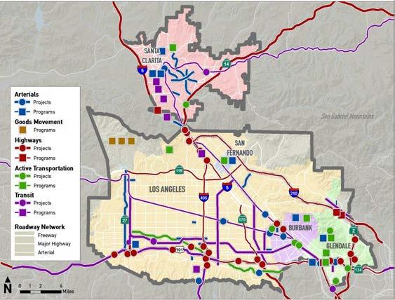
75 A BCDEFFCF BBFBDDABD C*&!*,)& Figure 1-1. Mobility Matrix Subregions Overview Figure 1-2. San Fernando Valley Mobility Matrix Study Area Figure Land Use SFVCOG Mobility Matrix Subregion Figure Population and Employment SFVCOG Mobility Matrix Subregion Figure 3-3. Population and Employment Change SFVCOG Mobility Matrix Subregion Figure 3-4. Environmental Justice Communities in Study Area Figure 3-5. Pollution Burdens and Vulnerable Populations, Relative to Los Angeles County Figure 4-1. Daily Trip Productions and Attractions (2014) SFV Mobility Matrix Subregion Figure 4-2. AM Peak Hour Home-Based-Work Trip Productions and Attractions (2014) SFVCOG Mobility Matrix Subregion Figure 4-3. Daily Trip Productions and Attractions (2014) Santa Clarita Figure 5-1. Average Daily Traffic Volumes on SFVCOG Mobility Matrix Subregion Freeways Figure 5-2. AM Peak Hour Speeds on SFVCOG Mobility Matrix Subregion Freeways Figure 5-3. AM Peak-Hour Speeds on SFVCOG Mobility Matrix Subregion Arterials Figure 5-4. Designated Truck Routes SFVCOG Mobility Matrix Subregion Figure 5-5. Truck-Related Collisions SFVCOG Mobility Matrix Subregion Figure 6-1. Existing and Proposed Active Transportation Facilities - SFVCOG Mobility Matrix Subregion Figure 6-2. Number of Collisions from Figure 6-3. Severity of Collisions in Study Area, Figure 6-4. Bicycle and Pedestrian Collisions SFVCOG Mobility Matrix Subregion Figure 7-1. Transit Service SFVCOG Mobility Matrix Subregion Figure 7-2. Existing Fixed Guideway Lines SFVCOG Mobility Matrix Subregion D (2#"$ A B C D C E F D B E 3 B A A B A B C C F,4*'
76 A BCDEFFCF BBFBDDABD ADT Caltrans COG CSTAN ITS LOS LRTP Metro PCH PeMS SB SFV SFVCOG SRTP STAA B <& C*&!E<&B <& **!*& Average Daily Traffic California Department of Transportations Council of Governments Los Angeles Countywide Strategic Truck Arterial Network Intelligent Transportation Systems Level-of-Service Long Range Transportation Plan Los Angeles County Metropolitan Transportation Authority Pacific Coast Highway Caltrans Freeway Performance Monitoring System Senate Bill San Fernando Valley San Fernando Valley Council of Governments Short Range Transportation Plan Surface Transportation Assistance Act D (2#"$ A B C D C E F D B E 3 B A A B A B C C F,4'
77 A BCDEFFCF BBFBDDABD D (2#"$ A B C D C E F D B E 3 B A A B A B C C F,4'*
78 A BCDEFFCF BBFBDDABD "=# AE /E A "="!) ;,) The Los Angeles County Metropolitan Transportation Authority (Metro) initiated the development of seven subregional mobility matrices to provide consistent countywide corridor performance criteria to be used to identify and evaluate transportation improvements to address subregional needs. These matrices will provide a performance evaluation methodology to identify short, mid and long term projects through a subregional collaborative process. It is envisioned that these matrices will assist the subregions in identifying projects for future transportation funding as well as future updates to the Metro Long Range Transportation Plan (LRTP). In February 2014, the Metro Board approved the holistic countywide approach for preparing Mobility Matrices for the San Gabriel Valley Council of Governments (COG), Central Los Angeles, Westside Cities COG, San Fernando Valley COG, Las Virgenes/Malibu COG, North County Transportation Coalition, and South Bay Cities COG. For the purposes of the Mobility Matrix work effort, cities with membership in two COGs were given the opportunity by the Board to select one COG in which to participate. Specifically, the Arroyo Verdugo Cities local jurisdictions are included in both the SGVCOG and SFVCOG and that subregion decided to have the cities of La Cañada Flintridge, Pasadena and South Pasadena included in the SGVCOG, while Burbank and Glendale are included in the SFVCOG. The City of Santa Clarita opted to be included in the San Fernando Valley COG instead of North County. The Gateway Cities COG is developing its own Strategic Transportation Plan which will serve as their Mobility Matrix. These subregional boundaries, as defined for the Mobility Matrices, will be used in the analysis of existing conditions. An overview of the subregions being evaluated in the Mobility Matrix Studies is provided in Figure 1-1. The San Fernando Valley (SFV) Council of Governments (COG) was formed in 2010 with the adoption of a Joint Powers Agreement by the City and County of Los Angeles along with the Cities of Burbank, Glendale, San Fernando and Santa Clarita. The main purpose of the SFVCOG is to develop and implement subregional policies and plans that are unique to the greater San Fernando Valley region, and to voluntarily and cooperatively resolve differences among the COG members. An overview of the SFVCOG borders is shown in Figure 1-2. The long-term goal of the SFVCOG is to build consensus on a vision for a future transportation system that embraces efficiency and innovation for continuous improvement of the quality of life in the subregions. To accomplish this goal, a mobility matrix will be developed for the SFVCOG region as part of this project that identifies and applies screening criteria to corridors in the subregion to develop a framework for potential transportation improvements. "=2!)&!)!) This document establishes baseline conditions in the SFVCOG Mobility Matrix Subregion. It includes existing projects and an overview of the study area s demographics, as well as develops a high level inventory of the transportation facilities being evaluated, including D (2#"$ A B C D C E F D B E 3 B A A B A B C C F,4"4"
79 A BCDEFFCF BBFBDDABD highways, arterials, transit, bike/pedestrian, and goods movement. Section 2.0 describes the existing projects and plans in the subregions, and their relationship to the Mobility Matrix goals. The demographics of the study area are covered in Section 3.0. Section 4.0 contains an overview of existing travel patterns. Sections 5.0, 6.0, and 7.0 analyze the freeways and arterials, the active transportation facilities, and transit service in the area, respectively. Finally, Section 8.0 provides a summary and conclusions. D (2#"$ A B C D C E F D B E 3 B A A B A B C C F,4"42

80 A BCDEFFCF BBFBDDABD *,)"4"=D*-*!D!*5),*&3 ''*: Source: STV, 2015 D (2#"$ A B C D C E F D B E 3 B A A B A B C C F,4"4+
B Source: STV, 2015 D (2#\"$ A B C D C E F D B E 3 B A A")
81 A BCDEFFCF BBFBDDABD *,)"42=--D*-*!D!*5!)B Source: STV, 2015 D (2#"$ A B C D C E F D B E 3 B A A B A B C C F,4"46
82 A BCDEFFCF BBFBDDABD 2=# EA >/EBAE Table 2-1 lists projects within the SFVCOG Mobility Matrix Subregion which have been recently completed or are in progress. The projects were drawn from a variety of sources, including the preliminary project list, the cities General Plans, Metro s Call for Projects, and other regional planning documents. The status of these projects has been confirmed after meeting with representatives from each of the COG cities. The projects include those which are local in scope, but help achieve the Mobility Matrix goals, as well as projects with wider subregional and regional impacts. D (2#"$ A B C D C E F D B E 3 B A A B A B C C F,424"
83 A BCDEFFCF BBFBDDABD E-24"=C*&!/<-!)?!&?!E Burbank-Glendale Traffic System Coordination Funded Traveler Information and Wayfinding System Funded Burbank Los Angeles River Bridge In design San Fernando Bikeway In design San Fernando Blvd/Burbank Blvd intersection improvements In design Grandview Ave at-grade railroad crossing modifications Completed Glendale Sonora Ave at-grade railroad crossing modifications Completed Traffic signal and ITS improvements Completed Colfax Bridge replacement Completed Los Angeles Widen Tujunga Ave Bridge over LA River Completed Local ITMS Phase IV interconnect gap closure and signal synchronization Funded Citywide wayfinding program for pedestrians and bicyclists In design Golden Valley Rd and SR-14 roadway capacity and intersection improvements In design McBean Parkway widening/gap closure over Santa Clara River Completed Santa Clarita Santa Clarita Citywide public information relay system Completed Golden Valley Rd bridge: connecting Soledad Canyon to Newhall Ranch Rd Completed Newhall Ranch Rd from Golden Valley Rd to Bouquet Canyon Rd Completed ITMS Phase III and signal synchronization gap closure Completed McBean Regional Transit Center park-and-ride Completed Newhall Gateway roundabout Completed I-5/Olive Ave overpass In design I-5/Magnolia Blvd overpass In design Regional I-5 I-5 Empire Project In construction I-5/SR-170 Interchange In construction I-5/SR-14 interchange and HOV lanes Completed Metro Orange Line Orange Line extensions from Canoga Station to Chatsworth Metrolink Station Completed D (2#"$ A B C D C E F D B E 3 B A A B A B C C F,4242
84 A BCDEFFCF BBFBDDABD +=# EFBBD BA/ The following section describes general demographic characteristics for the SFVCOG study area. Characteristics that are examined include land use patterns, population and employment, and environmental justice communities. +=" C& About one-third of the area is open and vacant land. Housing covers about 37% of the study area. The City of Los Angeles -SFV and the City of San Fernando have half of their land uses covered by single family housing, while E-+4"=C&&*!)B Burbank and Glendale have slightly higher concentrations of multi-family housing. Commercial properties make up 9% of the study area, with major shopping centers in Glendale, Santa Clarita, and near Warner Center. The City of San Fernando has a high percentage of commercial land uses, 17%, due to the City s commercial corridor specific plans. Industrial land uses are concentrated along the Metrolink corridors, and represent 5% of the study area. The SFVCOG Mobility Matrix Subregion s land uses are shown in Table 3-1 and Figure 3-1, with the data and categories taken from the 2008 SCAG land use database. C:&*! &*!*- D*)<@A*,( &*! &*!*- /<< *- )&!*- )-* *-*!*&@ &!*!)!*& E&!!*@!*-*!*& D*5&!!( D (2#"$ Burbank 36% 9% 7% 7% 3% 7% 2% 3% 27% 1% Glendale 30% 7% 9% 4% 3% 3% 0% 3% 39% 2% San Fernando 51% 3% 17% 14% 3% 3% 0% 2% 1% 6% Santa Clarita 25% 3% 8% 6% 1% 4% 0% 4% 44% 5% Los Angeles-SFV 45% 5% 11% 5% 5% 6% 0% 4% 18% 3% SFVCOG Study Area 35% 4% 9% 5% 3% 4% 0% 3% 33% 3% Source: STV, 2015; SCAG, 2008 A B C D C E F D B E 3 B A A B A B C C F,4+4"

85 A BCDEFFCF BBFBDDABD *,)+4"=2##BC&3/ D*-*!D!*5),* Source: STV, 2015; SCAG, 2008 D (2#"$ A B C D C E F D B E 3 B A A B A B C C F,4+42
86 A BCDEFFCF BBFBDDABD +=2 )-!*<-<! +=2=" 2#"6)-!*<-<! Employment and population density in the SFVCOG Mobility Matrix Subregion varies from city to city. Santa Clarita is the least dense in terms of both employment and population, while the City of San Fernando and the City of Los Angeles-SFV have the highest population densities. Glendale and Burbank are also dense, although their numbers are somewhat skewed by the large amount of open and vacant space in the cities in the Verdugo Hills. Employment is currently highly concentrated around employment centers, such as Warner Center, downtown Burbank, Ventura Boulevard, Media District, and downtown Glendale. E-+42=2#"6)-!*<-<!&*!*&3/ D*-*!D!*5),* /*! )-!*&*! <-<!&*! Burbank 5,916 4,896 Glendale 6,441 3,159 San Fernando 9,916 6,306 Santa Clarita 3,194 1,442 Los Angeles-SFV 7,413 3,197 Source: STV, 2015; Metro 2014 SRTP Table 3-2 shows the 2014 population and employment densities for the cities, with data drawn from the Metro 2014 Short Range Transportation Plan (SRTP). Figure 3-2 shows the 2014 population and employment for the study area. D (2#"$ A B C D C E F D B E 3 B A A B A B C C F,4+4+

87 A BCDEFFCF BBFBDDABD *,)+42=2#"6)-!*<-<!3/ D*-*!D!*5),* Source: STV, 2015; Metro 2014 SRTP D (2#"$ A B C D C E F D B E 3 B A A B A B C C F,4+46
88 A BCDEFFCF BBFBDDABD +=2=2 )-!*<-<!/(, The growth rates for jobs and employment are fairly balanced in Glendale, Santa Clarita, and in the San Fernando Valley, as well as for the SFV Mobility Matrix Subregion overall. In Burbank, however, employment growth is twice that of population growth, while San Fernando has the inverse trend. From 2014 to 2024, residential and employment growth will mostly be concentrated in Santa Clarita. Employment growth will mostly concentrate around existing job centers, including Universal City and Warner Center. Table 3-3 summarizes the changes in population and employments in the cities and in the SFVCOG Mobility Matrix Subregion, with data drawn from Metro s SRTP model. Figure 3-3shows the projected changes from 2014 to E-+4+=?!)-!*<-<!/(,.2#"64 2#263/ D*-*!D!*5),* /*! E 2#"6 2#26 F (, Burbank Glendale Residents 103, , % Jobs 90, , % Residents 190, , % Jobs 93,416 97, % San Residents 23,681 24, % Fernando Jobs 15,060 15, % Santa Clarita Los Angeles- SFV SFVCOG Study Area LA County Residents 205, , % Jobs 92, , % Residents 1,443,760 1,528, % Jobs 610, , % Residents 1,966,775 2,097, % Jobs 902, , % Residents 9,401,206 10,075, % Jobs 4,159,639 4,374, % Source: STV, 2015; Metro 2014 SRTP D (2#"$ A B C D C E F D B E 3 B A A B A B C C F,4+4$
89 A BCDEFFCF BBFBDDABD *,)+4+=)-!*<-<!/(,32#"642#263/ D*-*!D!*5),* Source: STV, 2015; Metro 2014 SRTP D (2#"$ A B C D C E F D B E 3 B A A B A B C C F,4+4G
90 A BCDEFFCF BBFBDDABD +=+ '*<!->)&!* /<<)*!*& +=+=" D**!C:4 <)-!*& The SFVCOG Mobility Matrix Subregion has several communities which may bear higher environmental burdens, compared to the rest of the county. The Cities of San Fernando and Los Angeles-SFV both have high percentages of minority and low-income populations, compared to the rest of the study area and to Los Angeles County. The City of San Fernando has the largest minority population in the SFVCOG Mobility Matrix Subregion, 93%, as well as the highest low-income population at 19%. In Los Angeles-SFV, 63% of the population is minority and 15.8% are in poverty. Additionally, most of the areas with transit dependent populations are in Los Angeles-SFV. Table 3-4 provides an overview of some racial and economic characteristics for the cities in the SFVCOG Mobility Matrix Subregion, with data from the 2010 Census. Figure 3-4 shows the median household income in the study area, using data from the 2013 American Community Survey. Additionally, the map uses data from the Metro 2014 SRTP and shows the areas with transit dependent communities. E-+46= *- <* /(!*&!* &:*!(*!)B /<<)*!!,E!- D**! D* A)&(- < " )-!*C*'*, -:'! C'- Burbank 42% $67,662 8% Glendale 37% $62,690 13% San Fernando 93% $50,768 19% Santa Clarita 47% $90,883 8% Los Angeles-SFV 63% $63,248 16% Los Angeles County 72% $55,476 16% 1 Median income was determined by averaging the median income of Census tracts groups that were within the study area Source: STV, 2015; Census, 2010 D (2#"$ A B C D C E F D B E 3 B A A B A B C C F,4+41
B Source: STV, 2015; Metro 2014 SRTP; American Community Survey, 2013 D (2#\"$ A B C")
91 A BCDEFFCF BBFBDDABD *,)+46='*<!->)&!* /<<)*!*&*!)B Source: STV, 2015; Metro 2014 SRTP; American Community Survey, 2013 D (2#"$ A B C D C E F D B E 3 B A A B A B C C F,4+4B
92 A BCDEFFCF BBFBDDABD +=+=2 --)!*)--)-!*& The CalEnviroScreen 2.0 methodology was used to evaluate communities which may be disproportionately burdened by pollution. The CalEnviroScreen scores incorporate a broad range of factors related to pollution and health; they include environmental indicators, such as particulate matter and traffic, and also socioeconomic characteristics, such as elderly populations, poverty levels, and educational attainment. Census tracts with lower scores have a lesser pollution burden, while tracts with higher scores face higher environmental risks and have more sensitive populations. representing the lowest burden and red representing the highest. Santa Clarita has the lowest scores in the SFVCOG Mobility Matrix Subregion, as their pollution burdens are fairly low and there are fewer low-income and minority populations. Burbank and Glendale s scores are mixed, with much higher pollution scores near the freeways, but their population scores overall are average compared to the SFVCOG Mobility Matrix Subregion. The City of San Fernando and the eastern portion of San Fernando Valley in Los Angeles face the highest risk, on both environmental and socioeconomic counts. The proximity to freeways and socioeconomic characteristics of those communities contribute to a higher pollution burden. Many of these communities in the highest percentiles for pollution risk are also overlap with the ones with transit-dependent populations. Figure 3-5 illustrates the pollution burdens for the study area, relative to the scores for the entire County. The scores are broken down into percentiles, with green D (2#"$ A B C D C E F D B E 3 B A A B A B C C F,4+40

93 A BCDEFFCF BBFBDDABD *,)+4$=--)!*)&)--)-!*&.-!*'!C&B,-&/)! Source: STV, 2015; CalEPA, 2014 D (2#"$ A B C D C E F D B E 3 B A A B A B C C F,4+4"#
94 A BCDEFFCF BBFBDDABD D (2#"$ A B C D C E F D B E 3 B A A B A B C C F,4+4""
95 A BCDEFFCF BBFBDDABD 6=# EBCDB7E To set the stage for examining the existing transportation system in the SFVCOG Mobility Matrix Subregion, this section analyzes the key travel markets of the area. This can be used to determine where commuters are heading to/from, and which movements require the most attention for potential improvement programs and projects. E*B!!!*: Non-home end (origin or destination) of a home-based trip, or destination of a non-home based trip. The plots and data provided show daily person trips, which include all trips made for any reason throughout the day, and home based work trips which are trips from home to work and back. 6=" **!*& Subregional trip patterns were developed using the Metro model (year 2014). The model data were summarized for two conditions: Total Daily Person Trips, and AM Peak Hour Home Based Work Trips. The model was used to determine the number of trips to and from the SFVCOG Mobility Matrix Subregion to other Southern California destinations, and vice versa. This gives a general understanding of the major travel patterns associated with people who live and work in the SFVCOG Mobility Matrix Subregion. Some basic definitions that apply to trips as described in this section are as follows: E*: One-way journey or movement from a point of origin to a point of destination. A<4&!*: When the home of the trip maker is either the origin or destination of the trip. A4(<&!*: Neither end of the trip is the home of the trip maker. E*)!*: Home end (origin or destination) of a home-based trip, or origin of a non-home-based trip. D (2#"$ A B C D C E F D B E 3 B A A B A B C C F,464"
96 A BCDEFFCF BBFBDDABD 6=2 *-E*!!& The model shows approximately 7 million total daily trips are produced and 7 million attracted each day for the SFV study area. Over three-quarters of those trips stay within the SFVCOG Mobility Matrix Subregion. This indicates a higher job/housing balance in this Mobility Matrix Subregion, as many of the trips each day do not leave the SFV study area. The highest trip producer and attractor areas are the Central and Westside Mobility Matrix Subregions, with approximately 5% and 4% of daily trips to and from the San Fernando Valley, respectively. Table 4-1 and Figure 4-1 show the daily trips produced and attracted for the SFVCOG Mobility Matrix Subregion. E-64"=*-E*)!*&B!!!*&C2#"6E3/ D*-*!D!*5),* E@< ),* E*&) FE*& ) E*&B!!! FE*& B!!! -- $ GF $ BF Central Los Angeles 402,330 6% 354,161 5% San Gabriel Valley 220,114 3% 217,582 3% Westside 327,866 5% 173,019 2% Ventura Co 126,223 2% 144,677 2% Gateway Cities 130,503 2% 123,663 2% North County 134,642 2% 193,705 3% Other 325,702 5% 312,461 5% E!- 1.#0#.1#0 "##F G.062.$01 "##F Source: Iteris, 2014; Metro 2014 SRTP Note: Trip patterns are based on aggregation of trip table data from the Travel Demand Model utilized for the Metro 2014 SRTP formatted by Los Angeles County subregional boundaries, as depicted in the Mobility Matrix work effort, which do not exactly correspond to the 2009 Metro LRTP subregional boundaries. D (2#"$ A B C D C E F D B E 3 B A A B A B C C F,4642

97 A BCDEFFCF BBFBDDABD *,)64"=*-E*)!*&B!!!*&C2#"6E3D*-*!D!*5),* Source: STV, 2015; Iteris, 2014; Metro 2014 SRTP. Note: See Page 4-2 regarding subregional boundaries. D (2#"$ A B C D C E F D B E 3 B A A B A B C C F,464+
98 A BCDEFFCF BBFBDDABD 6=+ BD;A)E*!!& For AM peak hour home-based-work trips, there are about 933,000 AM outbound trips and 914,400 AM inbound. Almost 60% of all the morning commute trips stay within the study area, indicating that a substantial portion of the residents in the SFVCOG Mobility Matrix Subregion live and work in the SFVCOG Mobility Matrix Subregion. The Central and the Westside Mobility Matrix Subregions are the two biggest producers and attracters of AM trips. Of all the outbound work trips, 12% go to the Westside, and 11% go to the Central area. About 7% of the incoming trips come from the Central area. The work trip interaction with the remaining Mobility Matrix subregions and the San Fernando Valley is relatively balanced, with most of the other areas each accounting for less than 5% of the trip interactions per Mobility Matrix subregion. Table 4-2 lists the trips produced and attracted for the study area. Figure 4-2 illustrates the inbound and outbound directions of the trips. E-642=BD;A)A<4&4%;E*)!*& B!!!*&C2#"6#3/ D*-*!D!*5),* E@< ),* E*&) FE*& ) E*&B!!! FE*& B!!! -- $6#.1BB $BF $6#.1BB $0F Westside 115,708 12% 36,996 4% Central Los Angeles 101,897 11% 62,945 7% San Gabriel Valley 45,049 5% 59,486 7% Gateway Cities 32,628 3% 33,163 4% Ventura Co 26,924 3% 50,982 6% South Bay 22,966 2% 28,304 3% North County 19,475 2% 61,817 7% Malibu 16,426 2% 13,679 1% Other 11,149 1% 26,224 3% E!- 0++.#"# "##F 0"6.+B6 "##F Source: Iteris, 2014; Metro 2014 SRTP Note: Trip patterns are based on aggregation of trip table data from the Travel Demand Model utilized for the Metro 2014 SRTP formatted by Los Angeles County subregional boundaries, as depicted in the Mobility Matrix work effort, which do not exactly correspond to the 2009 Metro LRTP subregional boundaries. D (2#"$ A B C D C E F D B E 3 B A A B A B C C F,4646

99 A BCDEFFCF BBFBDDABD *,)642=BD;A)A<4&4%;E*)!*&B!!!*&C2#"6E3/ D*-*!D!*5),* Source: STV, 2015; Iteris, 2014; Metro 2014 SRTP. Note: See Page 4-4 regarding subregional boundaries. D (2#"$ A B C D C E F D B E 3 B A A B A B C C F,464$
100 A BCDEFFCF BBFBDDABD 6=6 E'-%*!(*!)B The SFVCOG Mobility Matrix Subregion includes not only the SFV subregion, but also Santa Clarita from the North County subregion. The Santa Clarita Valley has about the same trip interaction with both the San Fernando Valley and the North County subregions. About 12% of trips are to and from North County, and 12% are to and from the San Fernando Valley. Nearly two-thirds of daily trips stay within the Santa Clarita area, and about 40% of home based work trips stay within the SFVCOG Mobility Matrix Subregion. This is likely due to the relatively longer distance to other areas, thus creating more internal trips to satisfy shopping, school, and other trip purposes. Figure 4-3 show the trip volumes to and from Santa Clarita from the surrounding Mobility Matrix subregions. D (2#"$ A B C D C E F D B E 3 B A A B A B C C F,464G

101 A BCDEFFCF BBFBDDABD *,)64+=*-E*)!*&B!!!*&C2#"6E3!/-*! Source: STV, 2015; Iteris, 2014; Metro 2014 SRTP. Note: See Page 4-4 regarding subregional boundaries. D (2#"$ A B C D C E F D B E 3 B A A B A B C C F,4641
102 A BCDEFFCF BBFBDDABD $=# %BFBABEBC Travel demand modeling analysis, as well as review of speeds and slow spots, was used to determine existing baseline conditions and future conditions on the freeways and key arterial roadways. $=" :-)<& The Caltrans Freeway Performance Monitoring System (PeMS) was used to assess freeway volumes and speeds. PeMS is used by Caltrans for performance analysis, including monitoring of traffic flow, congestion monitoring and estimating travel time reliability. Within the study area, Caltrans PeMS monitoring locations were available through the freeway system at various locations. The highest freeway volumes in the San Fernando Valley area occur on US-101 east of I-405, where the daily traffic flow is just over 350,000 vehicles. Other freeway segments that carry over 300,000 vehicles per day include I-405 between SR-118 and US-101: US-101 west of I-405; and I- 5 just south of SR-118. Most of the remaining freeway segments experience a daily flow of less than 200,000 vehicles per day. The SR- 210 and routes in the Santa Clarita Valley carry fewer daily travelers, compared to the rest of the study area. Figure 5-1 illustrates the average daily traffic (ADT) volumes in the SFVCOG Mobility Matrix Subregion. D (2#"$ A B C D C E F D B E 3 B A A B A B C C F,4$4"

<&/ D*")


103 A BCDEFFCF BBFBDDABD *,)$4"=B',*-E* -)<&/ D*-*!D!*5),*:& Source: STV, 2015; Iteris, 2014; Caltrans, 2014 D (2#"$ A B C D C E F D B E 3 B A A B A B C C F,4$42
104 A BCDEFFCF BBFBDDABD $=2 :& Using the PeMS database, average speeds were extracted for freeways in the study area. October 2013 speed data were reviewed to understand typical peak hour operating speeds on the freeway system in the SFVCOG Mobility Matrix Subregion. Only typical weekdays (non-holiday Tuesdays, Wednesdays and Thursdays) were used as a basis for the average speed data extraction. Speeds were extracted over the 24 hours of every weekday, with the peak hours chosen based on the slowest observed speeds during the peak commute period. During the AM peak hour, speeds under 30 mph are experienced along I-405 southbound, SR-101 in both directions throughout much of the study area, on I-5 southbound, along SR-14 southbound, and along a portion of SR-210 southbound just north of SR-2. These slow patterns reflect inbound work commute trips from the SFVCOG Mobility Matrix Subregion to employment opportunities to the south. During the PM peak hour, the opposite patterns are seen, with significant slowing along I-405 northbound, SR-14 northbound, and I-210 northbound. Much of US-101 is congested during the evening, in addition to portions of SR-118 eastbound and I-5 southbound. Figure 5-2 illustrates the AM peak hour freeway speeds in the SFVCOG Mobility Matrix Subregion. D (2#"$ A B C D C E F D B E 3 B A A B A B C C F,4$4+

105 A BCDEFFCF BBFBDDABD *,)$42=BD;A)&/ D*-*!D!*5),*:& Source: STV, 2015; Iteris, 2014; Caltrans, 2014 D (2#"$ A B C D C E F D B E 3 B A A B A B C C F,4$46
106 A BCDEFFCF BBFBDDABD $=+ B!*--)< Unlike the freeway PeMS system, there is no single comprehensive source of daily traffic flow information on arterial roadways. Many cities do not regularly collect traffic counts or only do so for special studies or as needed in selected locations. Due to the lack of available countbased arterial volume data, the Metro 2014 travel model was used to identify daily volumes on selected key arterial corridors. The model is a good tool to assess the overall magnitude of arterial traffic flow and to understand which roadways and segments carry the highest amount of traffic in the SFVCOG Mobility Matrix Subregion. Peak hour traffic speeds on the arterial roadways were also analyzed through the use of ipems system. The ipems gathers vehicle probe data along arterials and then delivers real-time and predictive traffic analytics. For this analysis, vehicle probe data were assessed for the months of January through April 2013, and for the hours of 7:30-8:30 AM and 4:30 to 5:30 PM. Similar to freeway PeMS, the data can be used to assess points of slowing on the arterial system. The corridors which were analyzed include arterial roadways that are a part of the 2010 Los Angeles County Congestion Management Program (CMP), along with other key regionally significant corridors that were selected for the study. Some of the highest arterial volumes (over 40,000 ADT) are seen on east/west oriented routes in the SFV area, including Nordhoff Street, Roscoe Boulevard, Sherman Way, Victory Boulevard, and portions of Ventura Boulevard. North/south streets carrying high volumes include Canoga Avenue, De Soto Avenue, Winnetka Avenue, and Tampa Avenue. In the Santa Clarita Valley, higher volumes are seen on portions of Sierra Highway, Soledad Canyon Road, Bouquet Canyon Road, and McBean Parkway. Peak hour slowing occurs on many of the major arterial roadways during one or both peak hours, and especially at intersections with other major arterials. The roadways with the largest segments with slow speeds include Ventura Boulevard, Van Nuys Boulevard, Lankershim Boulevard, Hollywood Way, Glenoaks Boulevard, Beverly Glen Boulevard, and Reseda Boulevard. While these roadways experience significant slowing in many areas with the SFVCOG Mobility Matrix Subregion, other arterials also experience slowing in more isolated segments. Figure 5-3 illustrates the average speeds for the AM peak period. D (2#"$ A B C D C E F D B E 3 B A A B A B C C F,4$4$

107 A BCDEFFCF BBFBDDABD *,)$4+=BD;4A)&/ D*-*!D!*5),*B!*-& Source: STV, 2015, Iteris, 2014 D (2#"$ A B C D C E F D B E 3 B A A B A B C C F,4$4G
108 A BCDEFFCF BBFBDDABD $=6 &D'<! The study area contains several routes which have been designated for use by trucks, including non-local through trucks which do not have a local destination. Other trucks making local deliveries can legally use the entire arterial system, unless specifically prohibited by ordinance. Non-local through trucks must use the designated truck route system, as shown. Traffic crash data for the three year period of 2008 to 2011 were reviewed to determine where crashes have occurred which involve a truck. The crash locations are spread out over the SFVCOG Mobility Matrix Subregion on several of the major arterials that also serve as designated truck routes, and even a few that are not truck routes, indicating those are likely local delivery truck routes. Figure 5-4 shows the truck routes in the SFVCOG Mobility Matrix Subregion, including municipal routes, routes designated by the Surface Transportation Assistance Act (STAA), and the DRAFT Los Angeles Countywide Strategic Truck Arterial Network (CSTAN). This is a strategic goods movement arterial plan network of facilities designated by Metro. Figure 5-5 shows the relative density of truck-involved crashes in the SFVCOG Mobility Matrix Subregion. D (2#"$ A B C D C E F D B E 3 B A A B A B C C F,4$41

109 A BCDEFFCF BBFBDDABD *,)$46=&*,!E) ;)!&3/ D*-*!D!*5),* Source: STV, 2015; Iteris, 2014 D (2#"$ A B C D C E F D B E 3 B A A B A B C C F,4$4B

110 A BCDEFFCF BBFBDDABD *,)$4$=E) ;4-!/--*&*&3/ D*-*!D!*5),* Source: STV, 2015; Iteris, 2014 D (2#"$ A B C D C E F D B E 3 B A A B A B C C F,4$40
111 A BCDEFFCF BBFBDDABD G=# B/EEBA EBE A The majority of the SFVCOG study area has been built with a suburban form that lends itself to bicycling or walking. With the exception of the fringes of the SFVCOG Mobility Matrix Subregion, most of the streets are laid out on a grid that provides a moderate to high level of connectivity. Arterial streets are generally spaced at onehalf mile apart with collector and local streets forming a finer network. The fine grid is more complete in the eastern parts of the study area than in the western portions. In the fringe areas, such as Santa Clarita, Granada Hills, Porter Ranch, and West Hills, the street network consists of primarily disconnected streets. Arterial streets lead to residential culs-de-sac with no grids and relatively few options for people to walk or bicycle from one street to the other without going along a circuitous route. This pattern makes schools, parks, stores, and other destinations inconvenient to reach by walking or bicycling. While some parts of the study area are fairly walkable and bikeable, Table 6-1 shows that bicycling and walking represent a very small percentage of commute modes in the SFVCOG Mobility Matrix Subregion, at less than 3% combined. About three quarters of commuters drive alone to work. E-G4"=* -*,%-;*,/<<)!D( D D( Bicycling 0.7% Walking 2.2% Drive Alone 73.5% Source: Census, 2010 Land use in the SFVCOG Mobility Matrix Subregion reflects the street networks. In the communities with more complete street grids, land uses are mixed enough to bring many destinations close enough to walk to, and more within bicycling distance. These areas generally fall somewhere in between dense urban development and sparse suburban development, which reflects the time period in which much of the area was built out. The fringe areas built in the 1980s and 1990s typically have disconnected street networks with separated land uses. D (2#"$ A B C D C E F D B E 3 B A A B A B C C F,4G4"
112 A BCDEFFCF BBFBDDABD G=" 5*&!*, *-*!*& Some communities within the SFVCOG Mobility Matrix Subregion have installed bikeways in limited locations. The following bikeway definitions are used. *;!(&C/-&&EExclusive paved paths separated from the roadway for bicyclists and other nonmotorized users *;-&C/-&&E Striped, stenciled and signed lanes in the street dedicated for bicycles *;)!&C/-&&ESigned bicycle routes in lanes that are shared with other traffic *;)-'&Bicycle routes that are enhanced with traffic calming measures such as, but not limited to, traffic circles in lieu of stop controls, roundabouts, diverters or bicycle-only traffic signals!!*;-&bike lanes that are in the street and are physically separated from the other travel lanes by parked cars, a painted area, planters or other barriers. * -4*-&!!: A type of Class III route that introduces street-calming engineering treatments on local and collector streets G=2 & *-*!*& Table 6-2 shows that Santa Clarita has a significant network of bike paths, and that the network of bike lanes and bike routes throughout the study area is growing. The network is far from complete, but it has grown to a point where many origins and destinations are within a mile or so from some type of bikeway. While some streets in the study areas have existing bikeways, conditions are still not ideal even on those streets. Table 6-3 shows currently planned facilities in the SFVCOG Mobility Matrix Subregion. Overall, total mileage of bikeways will approximately double. A large percentage of the new bikeways are attributable to Los Angeles bicycle-friendly streets, although half of the planned routes are lanes or paths. Eventually, the planned routes will create a robust bikeway network accessible from throughout the study area. Depending on the quality of the bike lanes, (regular, colored, buffered, or protected) the completed network could offer high-quality bicycling that has potential to attract many people to ride. Figure 6-1shows the existing and proposed bikeways and multi-purpose trails for the study area, which were collected from city bicycle plans and the County s Bicycle Master Plan. Several communities in the region also have horse trails and other facilities, which are depicted on the map. D (2#"$ A B C D C E F D B E 3 B A A B A B C C F,4G42

113 A BCDEFFCF BBFBDDABD *,)G4"=5*&!*,&B!*'E&!!* *-*!*&4/ D*-*!D!*5),* Source: STV, 2015; RSA, 2014 D (2#"$ A B C D C E F D B E 3 B A A B A B C C F,4G4+
114 A BCDEFFCF BBFBDDABD E-G42=5*&!*,*;:&*!)B ); -- C&B,-&!/-*! E!- E C,!(C<*=E C,!(C<*=E C,!(C<*=E C,!(C<*=E C,!(C<*=E C,!(C<*=E Bike path Bike lane Bike route Total Source: RSA, 2014 E-G4+=&*;:&*!)B ); -- C&B,-&!/-*! E!- E C,!(C<*=E C,!(C<*=E C,!(C<*=E C,!(C<*=E C,!(C<*=E C,!(C<*=E Bridge Bike boulevard Bike path Bike lane Bike route Bicyclefriendly street Total Source: RSA, 2014 D (2#"$ A B C D C E F D B E 3 B A A B A B C C F,4G46
115 A BCDEFFCF BBFBDDABD G=+! From 2008 to 2012, there has been an average of about 1,450 bicycle or pedestrian collisions per year, with a slight upward trend across the five years. Pedestrian collisions outnumber bicyclist collisions, although the latter rate has been increasing steadily each year. Most collisions result in moderate or minor injuries, while 2% of collisions are fatal. Figure 6-2 shows the general trend of collisions across the five years, and Figure 6-3 summarizes the severity of all the collisions. Figure 6-4 depicts the relative density of the incidents, showing several hot spots at major intersections as well as some high-incident corridors. *,)G42=A)</--*&*&<2##B42#" Pedestrian 400 Bicyclist Source: SWITRS, *,)G4+='*!/--*&*&*!)B.2##B42#"2 Fatal 2% Severe Injury 9% Minor Injury 43% Moderate Injury 46% Source: SWITRS, D (2#"$ A B C D C E F D B E 3 B A A B A B C C F,4G4$

116 A BCDEFFCF BBFBDDABD *,)G46=* -&!*/--*&*&2##B42#"23/ D*-*!D!*5),* Source: STV, 2015; SWITRS, D (2#"$ A B C D C E F D B E 3 B A A B A B C C F,4G4G
SUBREGIONAL MOBILITY MATRIX WESTSIDE CITIES Project No. PS U-01. Final Report
 SUBREGIONAL MOBILITY MATRIX WESTSIDE CITIES Project No. PS-4010-3041-U-01 Final Report Prepared for: Prepared by: Fehr & Peers 600 Wilshire Boulevard Suite 1050 Los Angeles, CA 90017 March 2015 Final Report
4. ENVIRONMENTAL IMPACT ANALYSIS 9. TRANSPORTATION AND TRAFFIC
 4. ENVIRONMENTAL IMPACT ANALYSIS 9. TRANSPORTATION AND TRAFFIC 4.9.1 INTRODUCTION The following section addresses the Proposed Project s impact on transportation and traffic based on the Traffic Study
I-105 Corridor Sustainability Study (CSS)
") I-105 Corridor Sustainability Study (CSS) Metro Streets and Freeways Subcommittee March 21, 2019 Gary Hamrick Cambridge Systematics, Inc. I-105 CSS Project History & Background Funded by Caltrans Sustainable
I-105 Corridor Sustainability Study (CSS) Metro Streets and Freeways Subcommittee March 21, 2019 Gary Hamrick Cambridge Systematics, Inc. I-105 CSS Project History & Background Funded by Caltrans Sustainable
Westside Transportation Access Needs Assessment - Short and Long Term Improvements
 ABSTRACT The Los Angeles County Metropolitan Transportation Authority (MTA) adopted the 2001 Long Range Transportation Plan (LRTP), which sets out the County s transportation investments for the next 20-25
South King County High-Capacity Transit Corridor Study
 HIGH-CAPACITY TRANSIT CORRIDOR STUDY South King County Corridor South King County High-Capacity Transit Corridor Study Corridor Report August 2014 South King County High Capacity Transit Corridor Report
% of Sales Tax (net of Admin) First Year Amount. Metro State of Good Repair 2% $ 17 $ 350 $ 910 $ 1,140 $ 2,400
 First Year Amount. Metro State of Good Repair 2% $ 17 $ 350 $ 910 $ 1,140 $ 2,400") Attachment A Proposed One-Half Cent Sales Tax for Transportation Outline of Expenditure Categories 40-s: Fiscal (FY ) 2018-2057, Escalated Dollars (millions) DRAFT Program % of Sales Tax (net of Admin)
Attachment A Proposed One-Half Cent Sales Tax for Transportation Outline of Expenditure Categories 40-s: Fiscal (FY ) 2018-2057, Escalated Dollars (millions) DRAFT Program % of Sales Tax (net of Admin)
Lyons Avenue/Dockweiler Road Extension Project Draft Environmental Impact Report. Appendix I Traffic Impact Study
 Lyons Avenue/Dockweiler Road Extension Project Draft Environmental Impact Report Appendix I Traffic Impact Study Street 0 80-1947 500.4501 RITA ld Court 0 91355-1096 400.7401 LA n Avenue 0 590-3745 300-9301
ADOT Statewide Bicycle and Pedestrian Program Summary of Phase IV Activities APPENDIX B PEDESTRIAN DEMAND INDEX
 ADOT Statewide Bicycle and Pedestrian Program Summary of Activities APPENDIX B PEDESTRIAN DEMAND INDEX May 24, 2009 Pedestrian Demand Index for State Highway Facilities Revised: May 29, 2007 Introduction
Chapter 4 Traffic Analysis
 Chapter 4 Traffic Analysis PURPOSE The traffic analysis component of the K-68 Corridor Management Plan incorporates information on the existing transportation network, such as traffic volumes and intersection
CITY OF COCOA BEACH 2025 COMPREHENSIVE PLAN. Section VIII Mobility Element Goals, Objectives, and Policies
 CITY OF COCOA BEACH 2025 COMPREHENSIVE PLAN Section VIII Mobility Element Goals, Objectives, and Policies Adopted August 6, 2015 by Ordinance No. 1591 VIII MOBILITY ELEMENT Table of Contents Page Number
EXECUTIVE SUMMARY... vii 1 STUDY OVERVIEW Study Scope Study Area Study Objectives
 Contents EXECUTIVE SUMMARY... vii 1 STUDY OVERVIEW... 1-1 1.1 Study Scope... 1-1 1.2 Study Area... 1-1 1.3 Study Objectives... 1-3 2 EXISTING CONDITIONS... 2-1 2.1 Existing Freeway Conditions... 2-4 2.1.1
Appendix C. NORTH METRO STATION AREA TRAFFIC IMPACT STATEMENT 88th Avenue Station
 Appendix C NORTH METRO STATION AREA TRAFFIC IMPACT STATEMENT 88th Avenue Station Prepared for: Regional Transportation Department and URS Corporation as part of the North Metro EIS David Evans and Associates,
1.0 INTRODUCTION 1.1 PURPOSE OF THIS REPORT
 1.0 INTRODUCTION This chapter provides an overview of the purpose, authorization and focus of this Recirculated Draft Environmental Impact Report (EIR), an identification of the Lead Agency, an outline
SANTA CLARA COUNTYWIDE BICYCLE PLAN August 2008
 SANTA CLARA COUNTYWIDE BICYCLE PLAN August 2008 To assist VTA and Member Agencies in the planning, development and programming of bicycle improvements in Santa Clara County. Vision Statement To establish,
Tulsa Metropolitan Area LONG RANGE TRANSPORTATION PLAN
 Tulsa Metropolitan Area LONG RANGE TRANSPORTATION PLAN Indian Nations Council of Governments August 2005 CONTACTING INCOG In developing the Destination 2030 Long Range Transportation Plan, INCOG s Transportation
TRANSPORTATION & MOBILITY
 TRANSPORTATION & MOBILITY ROADWAY SYSTEM There are approximately 40 miles of roadways in Manitou Springs. For planning purposes, roadways are typically assigned a functional classification which defines
MCTC 2018 RTP SCS and Madera County RIFP Multi-Modal Project Eval Criteria GV13.xlsx
 MCTC 8 RTP SCS and Madera County RIFP Multi-Modal Project Eval Criteria GV.xlsx Madera County Transportation Commission Regional Transportation Plan / Sustainable Communities Strategy Multi-Modal Project
AMENDING MOTION: Mobility Plan - Pedestrians and Disadvantaged Communities
 I MOVE that the Council: AMENDING MOTION: Mobility Plan - Pedestrians and Disadvantaged Communities 1. INSTRUCT the Department of City Planning to amend the proposed Mobility Plan to include the following;
North Coast Corridor:
 North Coast Corridor: Connecting People, Transportation & Environment Legislative Hearing: 11.8.10 1 North Coast Corridor Region s Lifeline A Regional Strategy Mobility, Economy & Environment North Coast
Regional Transportation Needs Within Southeastern Wisconsin
 Regional Transportation Needs Within Southeastern Wisconsin #118274 May 24, 2006 1 Introduction The Southeastern Wisconsin Regional Planning Commission (SEWRPC) is the official areawide planning agency
University Hill Transportation Study Technical Memorandum Alternatives Modeling and Analysis May 2007
 Technical Memorandum May 2007 Syracuse Metropolitan Transportation Council Edwards and Kelcey with Wallace Roberts and Todd Alta Planning and Design CONTENTS SECTION ONE- INTRODUCTION...1 SECTION TWO-
Key objectives of the survey were to gain a better understanding of:
 3 COMMUNITY INPUT Community input is an essential part of corridor studies. For the SR 87 corridor study, VTA staff conducted an extensive online survey of people living and commuting along the corridor.
ALTERNATIVES ANALYSIS EXECUTIVE SUMMARY
 West Valley Connector Corridor ALTERNATIVES ANALYSIS EXECUTIVE SUMMARY FINAL September 2014 Ontario International Airport Ontario Mills Rancho Cucamonga Metrolink Station Kaiser Permanente PARSONS EXECUTIVE
Chapter 14 PARLIER RELATIONSHIP TO CITY PLANS AND POLICIES. Recommendations to Improve Pedestrian Safety in the City of Parlier (2014)
") Chapter 14 PARLIER This chapter describes the current status and future plans for biking and walking in the City of Parlier. RELATIONSHIP TO CITY PLANS AND POLICIES The Parlier General Plan is the primary
Chapter 14 PARLIER This chapter describes the current status and future plans for biking and walking in the City of Parlier. RELATIONSHIP TO CITY PLANS AND POLICIES The Parlier General Plan is the primary
Chapter 6 Transportation Plan
 Chapter 6 Transportation Plan Transportation Plan Introduction Chapter 6 Transportation Plan Transportation Plan Introduction This chapter describes the components of Arvada s transportation system, comprised
Transportation Master Plan Advisory Task Force
 Transportation Master Plan Advisory Task Force Network Alternatives & Phasing Strategy February 2016 BACKGROUND Table of Contents BACKGROUND Purpose & Introduction 2 Linking the TMP to Key Council Approved
PEDESTRIAN ACTION PLAN
 ATTACHMENT 2 CITY OF SANTA MONICA PEDESTRIAN ACTION PLAN CITY OF SANTA MONICA PEDESTRIAN ACTION PLAN This page intentionally left blank EXECUTIVE SUMMARY CHAPTER 1 EXECUTIVE SUMMARY Setting the Stage
ACTIVE TRANSPORTATION
 ACTIVE TRANSPORTATION Mobility 2040 Supported Goals Improve the availability of transportation options for people and goods. Support travel efficiency measures and system enhancements targeted at congestion
Monterey Road Complete Streets
 Monterey Road Complete Streets Complete Street Objectives Improve livability and economic vitality Enhance pedestrian environment Accommodate bicyclists safely Reduce noise and air pollution Create attractive,
City of Wayzata Comprehensive Plan 2030 Transportation Chapter: Appendix A
 A1. Functional Classification Table A-1 illustrates the Metropolitan Council s detailed criteria established for the functional classification of roadways within the Twin Cities Metropolitan Area. Table
Basalt Creek Transportation Refinement Plan Recommendations
 Basalt Creek Transportation Refinement Plan Recommendations Introduction The Basalt Creek transportation planning effort analyzed future transportation conditions and evaluated alternative strategies for
SANTA MONICA BOULEVARD CORRIDOR
 CIRCULATION ELEMENT WHITE PAPER NO. 3 SANTA MONICA BOULEVARD CORRIDOR INTRODUCTION From the 1930s to the beginning of Los Angeles freeway era, Santa Monica Boulevard, (previously Route 66, the Beverly
Purpose and Need. Chapter Introduction. 2.2 Project Purpose and Need Project Purpose Project Need
 Chapter 2 Purpose and Need 2.1 Introduction The El Camino Real Bus Rapid Transit (BRT) Project (Project) would make transit and other transportation improvements along a 17.6-mile segment of the El Camino
North County Metro. Community Summaries, Maps and Matrices
 North County Metro Interstate 15 Mountain Meadow Road / Mirar De Valle Road Deer Springs Road Overview Sponsor Group Preferences The North County Metro sub-region includes two represented communities:
Chapter 13 ORANGE COVE
 Chapter 13 ORANGE COVE This chapter describes the current status and future plans for biking and walking in the City of Orange Cove. RELATIONSHIP TO CITY PLANS AND POLICIES The Orange Cove General Plan
Santa Clara I-280 CORRIDOR STUDY
 Santa Clara I-280 CORRIDOR STUDY OCTOBER 2017 PREPARED BY: 1.1 Background The I-280 Corridor Study within Santa Clara County is a high-level highway planning study led by the Santa Clara VTA, in partnership
DON MILLS-EGLINTON Mobility Hub Profile
 Mobility Hub Profile Dundas Don Mills-Eglinton West-Bloor Anchor Hub Gateway Hub N MOBILITY HUBS: Places of connectivity between regional and rapid transit services, where different modes of transportation
Planning Committee STAFF REPORT March 7, 2018 Page 2 of 4 The following MTSOs are being used across the five subregions: Intersection Level of Service
 Planning Committee STAFF REPORT Meeting Date: March 7, 2018 Subject Summary of Issues Recommendations Financial Implications Options Attachments Changes from Committee Review Draft 2017 Multimodal Transportation
Bus Rapid Transit Plans
 Twin Cities Region Bus Rapid Transit Plans ULI Minnesota Workshop Connecting Bus Rapid Transit to the Community December 15, 2009 John Levin Director of Service Development Metro Transit Metropolitan Area
Route 7 Corridor Study
 Route 7 Corridor Study Executive Summary Study Area The following report analyzes a segment of the Virginia State Route 7 corridor. The corridor study area, spanning over 5 miles in length, is a multi
Memorandum. Fund Allocation Fund Programming Policy/Legislation Plan/Study Capital Project Oversight/Delivery Budget/Finance Contract/Agreement Other:
 Memorandum Date: November 20, 2017 To: Transportation Authority Board From: Eric Cordoba Deputy Director Capital Projects Subject: 12/5/17 Board Meeting: San Francisco Freeway Corridor Management Study
East San Fernando Valley Transit Corridor. Draft EIS/EIR Public Hearing (September 1 thru October 16, 2017
 East San Fernando Valley Transit Corridor Draft EIS/EIR Public Hearing (September 1 thru October 16, 2017 1 Public Comments Release of Draft EIS/EIR September 1, 2017 through October 16, 2017 45-day Public
DRAFT BUENA VISTA 2020 TRANSPORTATION PLAN
 DRAFT BUENA VISTA 2020 TRANSPORTATION PLAN DEVELOPED BY THE TRANSPORTATION PLANNING DIVISION OF THE VIRGINIA DEPARTMENT OF TRANSPORTATION IN COOPERATION WITH THE U.S. DEPARTMENT OF TRANSPORTATION, FEDERAL
TRAFFIC IMPACT ANALYSIS
 TRAFFIC IMPACT ANALYSIS FOR THE CHAMPAIGN UNIT#4 SCHOOL DISTRICT PROPOSED HIGH SCHOOL (SPALDING PARK SITE) IN THE CITY OF CHAMPAIGN Final Report Champaign Urbana Urbanized Area Transportation Study 6/24/2014
Bridge Street Corridor Study Report
 Bridge Street Corridor Study Report Prepared for: Prepared by: BRIDGE STREET CORRIDOR STUDY REPORT PREPARED FOR: CITY OF ARROYO GRANDE COMMUNITY DEVELOPMENT DEPARTMENT 300 EAST BRANCH STREET ARROYO GRANDE,
Moving Cambridge. City of Cambridge Transportation Master Plan Public Consultation Centre. March 7, :00 8:00 PM.
 City of Cambridge Transportation Master Plan Public Consultation Centre March 7, 2018 5:00 8:00 PM Region of Waterloo City of Cambridge Transportation Master Plan Public Consultation Centre March 7, 2018
Performance Criteria for 2035 Long Range Transportation Plan
 Minimizing Impacts on Natural, Historic, Cultural or Archeological Resources 2035 LRTP Weighting Factor: 7% Objective 1.1: Use appropriate planning and design criteria to protect and enhance the built
City of Jacksonville Mobility Fee Update
 City of Jacksonville Mobility Fee Update 2017 Preliminary Analysis May 3, 2017 Carnival Cruise lines photo credit Presentation Overview Public Outreach Process Pedestrian and Bicycle Master Plan Study
City of Homewood Transportation Plan
 City of Homewood Transportation Plan Prepared for: City of Homewood, Alabama Prepared by: Skipper Consulting, Inc. May 2007 TABLE OF CONTENTS INTRODUCTION... 1 BACKGROUND INFORMATION... 1 EXISTING TRANSPORTATION
Corporate. Report COUNCIL DATE: June 26, 2006 NO: C012 COUNCIL-IN-COMMITTEE. TO: Mayor & Council DATE: June 22, 2006
 Corporate NO: C012 Report COUNCIL DATE: June 26, 2006 COUNCIL-IN-COMMITTEE TO: Mayor & Council DATE: June 22, 2006 FROM: General Manager, Engineering FILE: 0410-20(MoT/Gate) SUBJECT: Surrey Response on
MOUNTAIN HOUSE SPECIFIC PLAN I 9.1 INTRODUCTION ASSUMPTIONS TRANSPORTATION FACILITIES TRANSPORTATION IMPROVEMENTS PHASING 9.
 CHAPTER NINE: TRANSPORTATION AND CIRCULATION 9.1 INTRODUCTION 9.1 9.2 ASSUMPTIONS 9.1 9.3 TRANSPORTATION FACILITIES 9.1 9.4 TRANSPORTATION IMPROVEMENTS PHASING 9.3 LIST OF FIGURES LIST OF TABLES Figure
RESOLUTION NO ?? A RESOLUTION OF THE CITY OF NEPTUNE BEACH ADOPTING A COMPLETE STREETS POLICY
 RESOLUTION NO. 2018-?? A RESOLUTION OF THE CITY OF NEPTUNE BEACH ADOPTING A COMPLETE STREETS POLICY WHEREAS, safe, convenient, and accessible transportation for all users is a priority of the City of Neptune
6.0 PEDESTRIAN AND BICYCLE FACILITIES 6.1 INTRODUCTION 6.2 BICYCLE DEMAND AND SUITABILITY Bicycle Demand
 6.0 PEDESTRIAN AND BICYCLE FACILITIES 6.1 INTRODUCTION Bicycle and pedestrian travel along and in the vicinity of the corridor is part of the vision of Somerset and Hunterdon counties and the integrated
Regional Bicycle Barriers Study
 Regional Bicycle Barriers Study Executive Summary Background and Purpose The 2040 Transportation Policy Plan (TPP) sets policies for planning and investment direction in the transportation system in the
M-58 HIGHWAY ACCESS MANAGEMENT STUDY Mullen Road to Bel-Ray Boulevard. Prepared for CITY OF BELTON. May 2016
 M-58 HIGHWAY ACCESS MANAGEMENT STUDY Prepared for CITY OF BELTON By May 2016 Introduction Missouri State Highway 58 (M-58 Highway) is a major commercial corridor in the City of Belton. As development has
Welcome. Background. Goals. Vision
 Welcome The formal Public Information Centre (PIC) for the Transportation Master Plan How We GO will be held in early 2017. At that time we will present the recommended transportation system for Niagara
Complete Streets Workshop Follow-up. April 27, 2011 Rockledge City Hall
 Complete Streets Workshop Follow-up April 27, 2011 Rockledge City Hall Agenda Complete Streets draft briefing presentation and sample policy language Share your Complete Streets projects and post workshop
Northbound San Jose Avenue & I-280 Off-Ramp Road Diet Pilot Project
 Project Overview Fed by a two-lane Interstate-280 (I-280) off-ramp, high vehicular volumes and speeds are longstanding issues along San Jose Avenue. Residents in the surrounding neighborhoods have expressed
METRO Light Rail: Changing Transit Markets in the Phoenix Metropolitan Area
 METRO Light Rail: Changing Transit Markets in the Phoenix Metropolitan Area Abhishek Dayal, AICP Planner III, METRO Light Rail Phoenix, AZ BACKGROUND Transit in the Phoenix Region Transit services in the
Provo City Transportation Master Plan
 Provo City Transportation Master Plan Provo, Utah Adopted: September, 011 UT09-1 1 West Mayflower Way, Ste. Lehi, Utah 80 p. 801/. www.halesengineering.com September, 011 EXECUTIVE SUMMARY Provo City is
Clackamas County Comprehensive Plan
 ROADWAYS The County s road system permits the movement of goods and people between communities and regions, using any of a variety of modes of travel. Roads provide access to virtually all property. They
JONESBORO HIGHWAY 63 HIGHWAY 18 CONNECTOR STUDY
 JONESBORO HIGHWAY 63 HIGHWAY 18 CONNECTOR STUDY Craighead County May 2007 JONESBORO HIGHWAY 63 HIGHWAY 18 CONNECTOR STUDY Craighead County May 2007 Prepared by Planning and Research Division Arkansas State
Classification Criteria
 SCHEDULE D TO RECOMMENDED OFFICIAL PLAN AMENDMENT NO. 40 SCHEDULE C-4 Road Criteria Criteria Traffic Service Objective Land Service/Access Typical Daily Traffic Volume Flow characteristics Travel Speed
Pedestrian Project List and Prioritization
 To: Kyle Wagenschutz, City of Memphis CC: From: Anne Conlon and John Cock, Alta Planning + Design Date: December, 2014 Re: Project List Development (Task 3.1-3.2) and Project List Prioritization (Task
5.3 TRAFFIC, CIRCULATION AND PARKING
 5.3 TRAFFIC, CIRCULATION AND PARKING This section is based upon the Downtown Lancaster Specific Plan Traffic Impact Analysis (April 2, 2008) and the Downtown Lancaster Specific Plan Parking Analysis (May
CITY OF ALPHARETTA DOWNTOWN MASTER PLAN TRAFFIC EVALUATION
 CITY OF ALPHARETTA DOWNTOWN MASTER PLAN TRAFFIC EVALUATION June 2015 CITY OF ALPHARETTA DOWNTOWN MASTER PLAN TRAFFIC EVALUATION Introduction The Alpharetta Downtown Master Plan was developed in the fall
SAN FRANCISCO MUNICIPAL TRANSPORTATION AGENCY
 THIS PRINT COVERS CALENDAR ITEM NO. : 11 DIVISION: Sustainable Streets BRIEF DESCRIPTION: SAN FRANCISCO MUNICIPAL TRANSPORTATION AGENCY Approving traffic modifications on Twin Peaks Boulevard between Christmas
TRASBURG RANSPORTATION
 TRASBURG RANSPORTATION LAN DEVELOPED BY THE TRANSPORTATION PLANNING DIVISION OF THE VIRGINIA DEPARTMENT OF TRANSPORTATION IN COOPERATION WITH THE U.S. DEPARTMENT OF TRANSPORTATION, FEDERAL HIGHWAY ADMINISTRATION
Magnolia Place. Traffic Impact Analysis. Prepared for: City of San Mateo. Prepared by: Hexagon Transportation Consultants, Inc.
 Magnolia Place Traffic Impact Analysis Prepared for: City of San Mateo Prepared by: Hexagon Transportation Consultants, Inc. Updated January 4, 2010 Table of Contents 1. Introduction...1 2. Existing Conditions...6
Welcome! San Jose Avenue Open House August 25, 2015
 Welcome! San Jose Avenue Open House August 25, 2015 Vision Zero The City and County of San Francisco adopted Vision Zero San Francisco Vision Zero High Injury Network as a policy in 2014, committing an
V. ENVIRONMENTAL IMPACT ANALYSIS K. TRANSPORTATION AND CIRCULATION
 V. ENVIRONMENTAL IMPACT ANALYSIS K. TRANSPORTATION AND CIRCULATION ENVIRONMENTAL SETTING The following section is based on the Draft Traffic Circulation Study for the Malibu La Paz Project (Traffic Study),
Solana Beach Comprehensive Active Transportation Strategy (CATS)
") Solana Beach Comprehensive Active Transportation Strategy (CATS) 3.0 Goals & Policies The Solana Beach CATS goals and objectives outlined below were largely drawn from the Solana Beach Circulation Element
Solana Beach Comprehensive Active Transportation Strategy (CATS) 3.0 Goals & Policies The Solana Beach CATS goals and objectives outlined below were largely drawn from the Solana Beach Circulation Element
Chapter 5 Future Transportation
 Chapter 5 Future Transportation The Future Land Use Plan identifies the desired land use designations. The land uses desired for Crozet depend, in large part, on the success of the transportation system,
NEWMARKET CENTRE Mobility Hub Profile
 Mobility Hub Profile Dundas Newmarket West-Bloor Centre Anchor Hub Gateway Hub N MOBILITY HUBS: Places of connectivity between regional and rapid transit services, where different modes of transportation
Complete Street Analysis of a Road Diet: Orange Grove Boulevard, Pasadena, CA
 Complete Street Analysis of a Road Diet: Orange Grove Boulevard, Pasadena, CA Aaron Elias, Bill Cisco Abstract As part of evaluating the feasibility of a road diet on Orange Grove Boulevard in Pasadena,
ORANGE LINE BUS RAPID TRANSIT SUSTAINABLE CORRIDOR IMPLEMENTATION PLAN
 FINAL PLAN ORANGE LINE BUS RAPID TRANSIT SUSTAINABLE CORRIDOR IMPLEMENTATION PLAN JUNE 29, 2012 ORANGE LINE BUS RAPID TRANSIT SUSTAINABLE CORRIDOR IMPLEMENTATION PLAN Final Plan June 29, 2012 This is
Environmental Assessment Findings & Recommendations. Public Hearing November 13, 2014
 Environmental Assessment Findings & Recommendations Public Hearing November 13, 2014 Welcome! Welcome and Introductions Project and Environmental Assessment Overview Public Comments Adjourn Purpose of
RapidRide Roosevelt Seat Sea t t le t le Depa De r pa t r men men t of Sept T an r sp an or sp t or a t t a ion
 RapidRide Roosevelt Seattle Bicycle Advisory Board 1 Our mission, vision, and core values Mission: deliver a high-quality transportation system for Seattle Vision: connected people, places, and products
Goal 3: Foster an environment of partnerships and collaboration to connect our communities and regions to one another.
 Non-Motorized Transportation Plan (NMTP) Draft Vision, Goal and,, Tri-County Regional Planning Commission (TCRPC) Purpose The purpose of the Tri-County Regional Planning Commission (TCRPC) Non-Motorized
4 MOBILITY PLAN. Mobility Plan Objectives. Mobility Context. 1. Integrate with Local and Regional Transit Improvements
 Harbor Mixed Use CHAPTER Transit Corridor 4: Mobility Plan 4 MOBILITY PLAN Mobility Plan Objectives The Harbor Corridor Plan seeks to expand and improve the ways that people move along and through the
Presentation of Staff Draft March 18, 2013 COUNTYWIDE TRANSIT CORRIDORS FUNCTIONAL MASTER PLAN
 Presentation of Staff Draft March 18, 2013 COUNTYWIDE TRANSIT CORRIDORS FUNCTIONAL MASTER PLAN Public Outreach Fall 2011: Two community meetings/open houses Fall 2012: Three community meetings/open houses
CITY OF LOS ANGELES INTER-DEPARTMENTAL CORRESPONDENCE
 CITY OF LOS ANGELES INTER-DEPARTMENTAL CORRESPONDENCE Date: May 9, 2017 To: Honorable City Council c/o City Clerk, Room 395, City Hall Attention: Honorable Mike Bonin, Chair, Transportation Committee From:
5. Pedestrian System. Accomplishments Over the Past Five Years
 5. Pedestrian System Accomplishments Over the Past Five Years The Alamo Area Metropolitan Planning Organization (MPO) and its partner agencies recognize the importance of improving pedestrian mobility.
New Seward and 36 th Avenue Intersection Conceptual Design
 University of Alaska Anchorage New Seward and 36 th Avenue Intersection Conceptual Design Prepared By: Zaid S. Hussein Dana Menendez Galen Jones Civil Engineering Department Prof. Osama Abaza CE A404 Highway
MOBILITY WORKSHOP. Joint City Council and Transportation Commission May 5, 2014
 MOBILITY WORKSHOP Joint City Council and Transportation Commission May 5, 2014 Review of General Plan M-1 Develop world-class transit system M-3 Maintain/enhance pedestrian-oriented City M-4 Create comprehensive
Sacramento Grid 2.0. The Downtown Transportation Study
 Sacramento Grid 2.0 The Downtown Transportation Study April 20, 2016 The Grid 4.25 square miles Street grid defined at birth of City Lettered and numbered streets spaced every 400 ft East-west alleys halfway
Bicycle and Pedestrian Chapter TPP Update Overview. TAB September 20, 2017
 Bicycle and Pedestrian Chapter TPP Update Overview TAB September 20, 2017 Bicycling & Walking in the Twin Cities Where are we now? The Bike-Pedestrian system Current trends New developments Where are we
Preliminary Review of the T-REX Southeast Corridor Highway and Light Rail Transit Project
 Preliminary Review of the T-REX Southeast Corridor Highway and Light Rail Transit Project DRCOG Congestion Mitigation Program White Paper 07-1 (February 16, 2007) On time and under budget! Festivities
SECTION 1 - TRAFFIC PLANNING
 SECTION 1 - TRAFFIC PLANNING 1.1 TRAFFIC OPERATIONS 1.1.1 Roadway Functional Classification The Multnomah County Comprehensive Framework Plan s Policy 34: Trafficways and the Functional Classification
Berkeley Strategic Transportation Plan A-76
 Berkeley Strategic Transportation Plan A-76 Appendices 1. A Team Effort 2. Where We ve Been A-11 Berkeley Strategic Transportation Plan Alameda County Transportation Plan Alameda County will be served
State Road 54/56 Tampa Bay s Northern Loop. The Managed Lane Solution Linking I-75 to the Suncoast Parkway
 State Road 54/56 Tampa Bay s Northern Loop The Managed Lane Solution Linking I-75 to the Suncoast Parkway SUNCOAST PARKWAY Both I 75 and the Suncoast Parkway are planning, or in the process of constructing,
Circulation in Elk Grove includes: Motor vehicles, including cars and trucks
 Circulation, as it is used in this General Plan, refers to the many ways people and goods move from place to place in Elk Grove and the region. Circulation in Elk Grove includes: Motor vehicles, including
4.2 LAND USE AND PLANNING
 4.2 LAND USE AND PLANNING This section provides an overview of land use and planning policies as proposed in the Mobility Plan 2035 (MP 2035 or proposed project). Topics addressed include division of an
San Jose Transportation Policy
 San Jose Transportation Policy Protected Intersections in LOS Policies to Support Smart Growth Presented by: Manuel Pineda City of San Jose Department of Transportation Bay Area Map San Francisco Oakland
Project Budget and Schedule Status
 Program Management Project Budget and Schedule Status Highway Program Planning & Programming Committee February 20, 2013 Highway Program Project Schedules Project 2010 2011 2012 2013 2015 2016 2017 2018
Exhibit 1 PLANNING COMMISSION AGENDA ITEM
 Exhibit 1 PLANNING COMMISSION AGENDA ITEM Project Name: Grand Junction Circulation Plan Grand Junction Complete Streets Policy Applicant: City of Grand Junction Representative: David Thornton Address:
City of Gainesville Transportation/Roadway Needs PROJECT SUMMARY
 A1 Roadway Resurfacing $23,846,000 TYPE: Preservation of existing system Roadway resurfacing A2 Signal Replacement $6,000,000 TYPE: Preservation of existing system Replace traffic signals. B1 W 6th St
5. RUNNINGWAY GUIDELINES
 5. RUNNINGWAY GUIDELINES These guidelines should be considered collectively when making runningway decisions. A runningway is the linear component of the transit system that forms the right-of-way reserved
Chapter 7. Transportation. Transportation Road Network Plan Transit Cyclists Pedestrians Multi-Use and Equestrian Trails
 Chapter 7 Transportation Transportation Road Network Plan Transit Cyclists Pedestrians Multi-Use and Equestrian Trails 7.1 TRANSPORTATION BACKGROUND The District of Maple Ridge faces a number of unique
DRAFT. Memo. Range of the Alternatives Considered in the EIS
 Memo Date: Friday, December 09, 2016 Project: To: From: Subject: State Route 30 EIS UDOT Vince Izzo This memorandum summarizes the draft State Route (S.R.) 30 Level 1 screening results. A more detailed