RED BANK CORRIDOR. Community Partners Committee Meeting Madisonville Recreation Center. May 21,
|
|
|
- Polly Barker
- 5 years ago
- Views:
Transcription
1 RED BANK CORRIDOR Community Partners Committee Meeting Madisonville Recreation Center May 21, 2013
2 RED BANK CORRIDOR PROJECT Create a balance of mobility and access to better serve local communities, businesses and neighborhoods Reduce congestion, delays Improve accessibility, safety, traffic flow Increase capacity to better support current and future traffic volumes Better accommodate bicyclists and pedestrians
3 RED BANK CORRIDOR TIMELINE Environmental Screening Spring 2011 Traffic Counts 2010/2011 Traffic Modeling Fall/Spring Develop Conceptual Alternatives Summer Public Involvement Refine Conceptual Alternatives Summer/Fall 2013 Select Preferred Alternative Fall/Winter 2013 Environmental Documentation Spring 2014 Develop plan for Implementation Ongoing
4 RED BANK PUBLIC INVOLVEMENT Cincinnati City Council Committee meeting August 2011 Three Madisonville Community Partners Committee meetings December 2011 Madisonville Recreation Center February 2012 Medpace May 2012 Madisonville Recreation Center Various stakeholder and property owner meetings
5 COMMENTS RECEIVED Provide shoulders north of Madison Slow through traffic on Red Bank Expressway Address congestion between Madison and Erie Improve pedestrian safety at Madison Improve Old Red Bank Road south of Hetzel including RR bridge Address cut-through traffic at Hetzel Provide separate bike/ped accommodations Erie/Brotherton connection is not intuitive Minimize footprint of any improvements
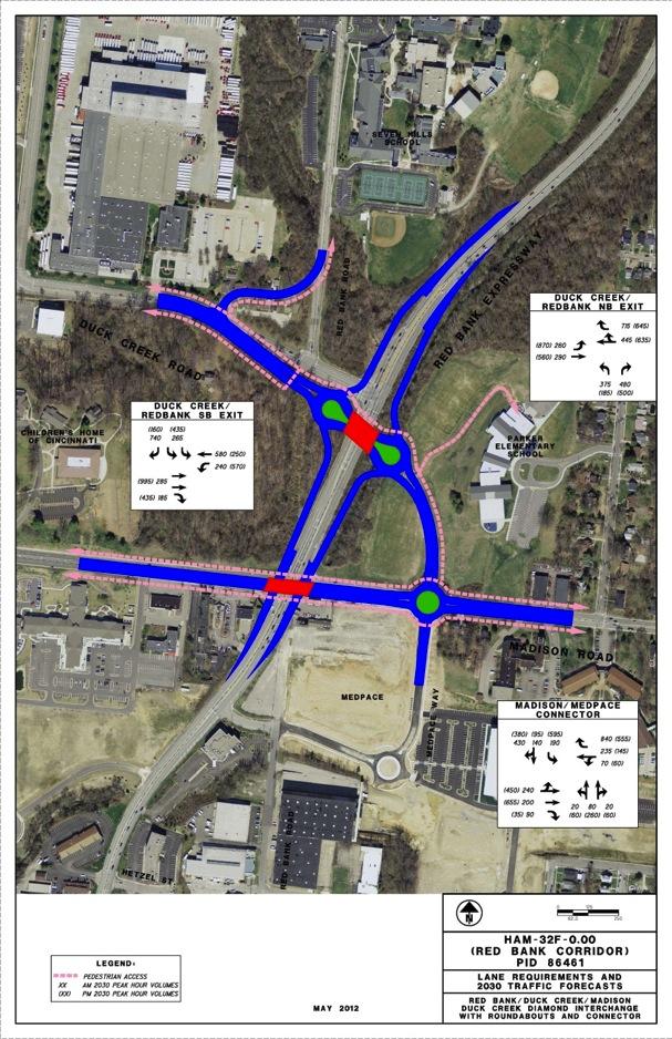
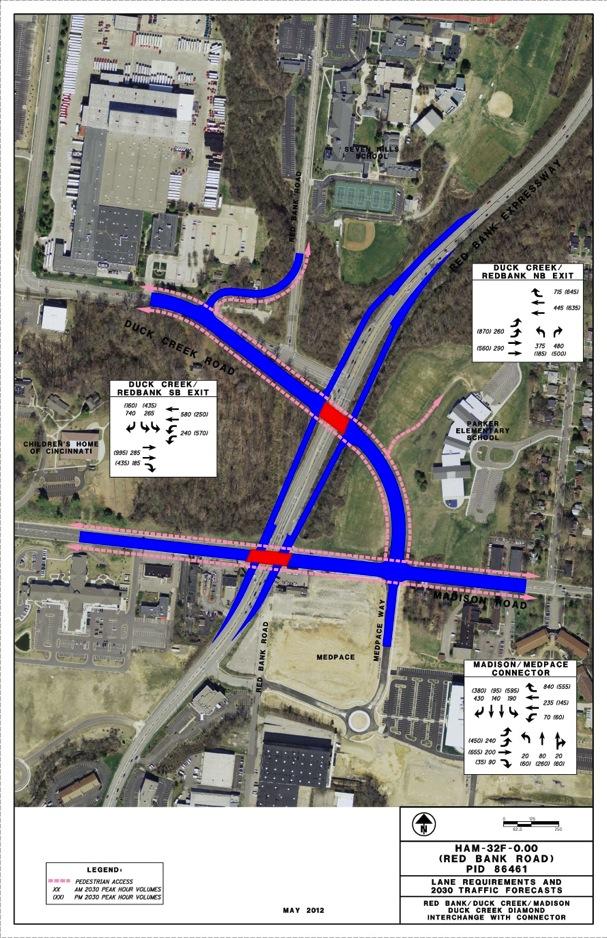
6 TRAFFIC FORECASTS Traffic counts establish current volumes Traffic forecasted for 2030 as basis for design 2030 forecasts developed with and without relocated SR-32 Connection to Eastgate Area Volumes increase on Red Bank and Decrease on Madison and other east west corridors with Relocated SR-32 Forecasted hourly volumes at intersections used to determine capacity Adjustments have been made to account for future build out of Medpace development
7 EXISTING INTERSECTION CAPACITY Intersections on Red Bank with Duck Creek and Madison do not operate satisfactorily today or in 2030 Traffic backs up north of Duck Creek and south of Hetzel during rush hours. Erie Avenue functions satisfactorily today but not in 2030 with Relocated SR-32 Red Bank functions with three/four lanes depending on intersection capacity.
8 CONCEPTUAL ALTERNATIVES Conceptual Alternatives for the following: Duck Creek/Red Bank Madison/Red Bank Erie/Brotherton/Red Bank
9 DUCK CREEK / RED BANK Increase through-capacity on Red Bank Short distance between Red Bank Expressway and Red Bank Road At-Grade or grade-separation Large left-turning percentages at Madison/Duck Creek Concerns about mixing peds and through-traffic Gateway design elements possible

10 DUCK CREEK / RED BANK
11 DUCK CREEK / RED BANK
12 DUCK CREEK ROAD MATRIX ALTERNATIVE DUCK CREEK - 1 ALTERNATIVE DUCK CREEK - 1A ALTERNATIVE DUCK CREEK - 2 ALTERNATIVE 1 - STRUCTURE POINT ALTERNATIVE 2 - STRUCTUREPOINT ALTERNATIVE 3 - STRUCTUREPOINT CITY ALTERNATIVE RED BANK EXPRESSWAY AND DUCK CREEK ROAD INTERSECTION WITH SIGNALIZED INTERSECTION AT RED BANK ROAD RED BANK EXPRESSWAY AND DUCK CREEK ROAD INTERSECTION WITH SIGNALIZED INTERSECTION AT RED BANK ROAD RED BANK EXPRESSWAY AND DUCK CREEK ROAD ROUNDABOUT WITH ROUNDABOUT AT RED BANK ROAD AT GRADE ROUNDABOUTS INTERCHANGE ROUNDABOUTS BYPASS TIGHT SPLIT DIAMOND WITH SIGNALIZED INTERSECTIONS Comments Comments Comments Comments Comments Comments Comments EVALUATION CATEGORY CONGESTION RELIEF/TRAFFIC OPERATIONS Efficient Traffic Movement Throughout Corridor ~Requires 3 thru lanes on the NB and SB approaches, a SB RTL, and dual NB LTL. ~Acceptable overall intersection LOS for Red Bank Exp./Duck Creek and Red Bank Rd./Duck Creek intersections. WB to NB traffic from Madison Rd. bypasses Duck Creek Rd. intersection. ~Requires 3 thru lanes on Red Bank NB and SB approaches, a SB RTL, and dual NB LTL ~Acceptable overall intersection LOS for Red Bank Exp./Duck Creek and Red Bank Rd./Duck Creek intersections. Reduces forecasted delay from "No Build" Alternative All NB traffic bypasses the Duck Creek Road intersection. Requires 3 lane roundabout to accommodate forecasted SB traffic volumes. Results in least amount of overall intersection delay of the alternatives presented. Current traffic microsimtuation models (Cydra) indicate that a multi lane roundabout is needed to accomodate forecasted traffic. Level of service must be verified. Intersection of Duck Creek Road & Red Bank Expwy will be grade separated, and through traffic will experience fewer delays. Intersection type of Duck Creek Road & Red Bank Expwy will be a roundabout having 2 lanes, which should improve traffic efficiency. Intersection of Duck Creek Road & Red Bank Expwy will be grade separated, and through traffic will experience fewer delays. Intersection type of Duck Creek Road & Red Bank Expwy will be a roundabout having 2 lanes, which should improve traffic efficiency. May require the elimination of Hetzel intersection. Removes Red Bank thru traffic from Duck Creek and Madison. All intersections operate at acceptable LOS. TRAFFIC SAFETY Expected to be improved due to reduced congestion & segregation of NB through movements Expected to be improved due to reduced congestion Roundabouts anticipated to result in lower overall accident rates than conventional signalized intersections. Roundabouts anticipated to result in lower overall accident rates than conventional signalized intersections however multi lane roundabout is not a typical configuration which may lead to vehicular conflicts for unfamiliar drivers. Roundabouts anticipated to result in lower overall accident rates than conventional signalized intersections. Grade separation of through and local traffic will reduce conflicting vehicular movements Roundabouts anticipated to result in lower overall accident rates than conventional signalized intersections. Grade separation of through and local traffic will reduce conflicting vehicular movements Reduces congestion so should improve traffic safety however signalized intersections typically have higher accident rates than roundabouts. ABILITY TO MEET DESIGN STANDARDS Intersection spacing on Duck Creek Rd. between Red Bank Exp. and Red Bank Rd. less than 600' recommended between signalized intersections. Signal operation will require complex coordination to minimize queuing impacts between signals similar to existing conditions. Intersection spacing on Duck Creek Rd. between Red Bank Exp. and Red Bank Rd. less than 600' recommended between signalized intersections. Signal operation will require complex coordination to minimize queuing impacts between signals similar to existing conditions. Need for design exceptions have not been identified at this time. S. B. free flow speeds will be below design speed. Intersection of Duck Creek Road & Red Bank Expwy will be at-grade and is expected to meet design standards. Intersection type of Duck Creek Road & Red Bank Expwy will be a roundabout having 2 lanes plus bypasses, but horizontal /vertical alignment might limit some design criteria. Intersection of Duck Creek Road & Red Bank Expwy will be grade separated, but short ramp lengths might limit vertical/ssd design criteria. Intersection type of Duck Creek Road & Red Bank Expwy will be a roundabout having 2 lanes, but horizontal /vertical alignment might limit some design criteria. No design exceptions anticipated. PEDESTRIAN MOVEMENT (MOBILITY AND SAFETY) Signalized intersections will have protected pedestrian movements similar to existing. Crossing distance is increased (6 lanes) on Duck Creek Rd. Signalized intersections will have protected pedestrian movements similar to existing. Crossing distance is increased (6 lanes) on Duck Creek Rd. Signalized intersections are not anticipated to as safe as roundabout configurations Roundabouts anticipated to be safer for pedestrians due to refuge and shorter crossing distances HAWK pedestrian signals will be required at multi-lane crossings for per ADA requirements Roundabouts anticipated to be safer for pedestrians due to refuge and shorter crossing distances HAWK pedestrian signals will be required at multi-lane crossings for per ADA requirements Roundabouts anticipated to be safer for pedestrians due to refuge and shorter crossing distances HAWK pedestrian signals will be required at multi-lane crossings for per ADA requirements Roundabouts anticipated to be safer for pedestrians due to refuge and shorter crossing distances HAWK pedestrian signals will be required at multi-lane crossings for per ADA requirements Improved pedestrian by reducing crossing distance, only one ramp at a time and removing Red Bank traffic from the intersection. CYCLISTS (MOBILITY AND SAFETY) Separate Shared Use Path along the west side of Red Bank Exp. is introduced at intersection. Nature of on-street bike facility to be determined Separate Shared Use Path along the west side of Red Bank Exp. is introduced at intersection. Nature of on-street bike facility to be determined Separate Shared Use Path along the west side of Red Bank Exp. is introduced at intersection. Nature of on-street bike facility to be determined. Bike movements in Roundabout may be problematic Separate Shared Use Path along the west side of Red Bank Exp. is introduced at intersection. Nature of on-street bike facility to be determined Improved similar to pedestrians. Bikes can be accommodated on structure over Red Bank Road. ACCESS TO BUSINESS Existing commercial property access is not impacted. Existing commercial property access is not impacted. Existing commercial property access is not impacted. Coke trucks will need to negotiate roundabouts Existing commercial property access is not impacted. Coke trucks will need to negotiate roundabouts Existing commercial property access is not impacted. Coke trucks will need to negotiate roundabouts. Requires grade separation at Madison Road Existing commercial property access is not impacted. Coke trucks will need to negotiate roundabouts. Some access on Red Bank will be eliminated and on Madison close to the Red Bank ramps. IMPROVED CLIMATE FOR ECONOMIC DEVELOPMENT Not anticipated to be a significant differential impact among alternatives Not anticipated to be a significant differential impact among alternatives Not anticipated to be a significant differential impact among alternatives Not anticipated to be a significant differential impact among alternatives Improved mobility, reduced congestion and improved safety should be good for economic development. Potential total take of businesses at corner of Red Bank/Madison. Substantial medians and roundabout interiors provide Substantial medians and roundabout interiors provide Substantial medians and roundabout interiors provide AESTHETICS (Develop and Preserve Green Space) Some impacts inside and outside of existing ROW. No impacts to Parker Elementary property and minimal impacts to Children's Home of Cincinnati property. Limited ability to incorporate significant urban design features Least impacts outside of existing ROW. No impacts to Parker Elementary and minimal impacts to Children's Home of Cincinnati property. Limited opportunity to incorporate significant urban design features. opportunity for urban design features. Potential new green space for Seven Hills School to mitigate impacts at Red Bank Expy. Provides opportunity for aesthetic treatments inside Substantial medians and roundabout interiors provide opportunity for urban design features. Provides opportunity for aesthetic treatments inside roundabout. opportunity for urban design features. Potential new green space for Seven Hills School to mitigate impacts at Red Bank Expy. Does remove most existing vegetation Provides opportunity for aesthetic treatments inside opportunity for urban design features. Potential new green space for Seven Hills School to mitigate impacts at Red Bank Expy. Provides opportunity for aesthetic treatments inside Positive from landscaping and street scaping. Can blend into aesthetics for the neighborhood. roundabout. roundabout. roundabout. Signalized intersection results in wide typical section. Median could include landscaping on Red Bank Expy. CONTEXT SENSITIVE DESIGN FEATURES NB bypass has potential impacts to Deerfield Creek. Community has shown preference for Roundabout designs Signalized intersection results in wide typical section. The roundabout will act as a speed control gateway between I-71 and the commercial area of Red Bank Exp. NB bypass has potential stream impacts The roundabout will act as a speed control gateway between I-71 and the commercial area of Red Bank Exp. NB bypass has potential stream impacts culvert will need to be extended New green spaces and medians provide ability to incorporate landscaping and urban design elements. New green spaces and medians provide ability to incorporate landscaping and urban design elements. Can fit into character of neighborhood. Lots of opportunity for hard and soft scape. Build only what is needed. PROPERTY IMPACTS AND R/W TAKES Minimal impacts outside existing R/W. Minimal r/w impacts. Anticipate five residential property relocations along Duck Creek Ct; relocation of Red Bank Road; expanded ROW on Red Bank Expressway. Preservation of existing residential property along Duck Creek may be problematic as currently shown. Largest footprint of all Duck Creek alternatives Larger footprint than at grade alternatives Total take required near intersection of Madison/Red Bank and loss of access on Red Bank from Madison to Hetzel. ENVIRONMENTAL RED FLAGS NB bypass has potential impacts to Deerfield Creek and vegetative cover. Minor utility impacts Anticipate minimal environmental/utility impacts. Larger footprint for removal of vegetation, stream impacts to Deerfield Creek. Residential property relocations. Likely utility impacts to water, sewer, electric. Larger footprint for removal of vegetation, some stream impacts to Deerfield Creek. Possible residential property relocations. Likely utility impacts to water, sewer, electric. Stream Impacts to Deerfield Creek. Largest footprint and removal of existing vegetation Stream impacts to Deerfield Creek. Potential ESA at intersection of Madison/Red Bank. Stream impacts to Deerfield Creek. Potential ESA at intersection of Madison/Red Bank. MOBILITY BETWEEN EXISTING COMMERCIAL AND RESIDENTIAL DEVELOPMENTS Not anticipated to be a significant differential impact among alternatives Not anticipated to be a significant differential impact among alternatives Not anticipated to be a significant differential impact among alternatives Not anticipated to be a significant differential impact among alternatives Not anticipated to be a significant differential impact among alternatives but grade separation should improve conflicts with through traffic. Not anticipated to be a significant differential impact among alternatives. Grade separation should improve conflicts with through traffic. Reduced congestion should improve mobility along Madison. Potential loss of Hetzel intersection could impact east west connectivity. CONSTRUCTION COST Cost anticipated to be less than grade separated alternatives Cost anticipated to be less than grade separated alternatives Cost anticipated to be less than grade separated alternatives Cost anticipated to be less than grade separated alternatives Higher than at grade options Higher than at grade options Higher than at grade options but not as complex as grade separated round about options CONSTRUCTABILITY No Significant constructability issues are anticipated No Significant constructability issues are anticipated Compact design with some MOT challenges Compact design with some MOT challenges MOT will be challenge MOT will be challenge MOT will be challenging but not as complex as roundabout grade separations.
13 MADISON /RED BANK Increase through-capacity on Red Bank Short distance to Duck Creek At-Grade or grade-separation Large left-turning percentages at Madison/Duck Creek Concerns about mixing peds and through-traffic Gateway design elements possible

14 CONCEPTUAL FOOTPRINTS Duck Creek/ Madison at Red Bank

15 MADISON / RED BANK
16 MADISON / RED BANK

17 MADISON / RED BANK

18 MADISON / RED BANK

19 MADISON / RED BANK

20 MADISON / RED BANK
21 MADISON ROAD MATRIX ALTERNATIVE MADISON - 1 RED BANK EXPRESSWAY AND MADISON ROAD INTERSECTION WITH EXISTING MEDPACE WAY ACCESS MAINTAINED ALTERNATIVE MADISON - 2A ALTERNATIVE MADISON - 2B RED BANK EXPRESSWAY AND MADISON ROAD RED BANK EXPRESSWAY AND MADISON ROAD ROUNDABOUTS WITH RED BANK ROAD TO MADISON ROAD ROUNDABOUTS WITH EXISTING MEDPACE WAY ACCESS CONNECTION MAINTAINED ALTERNATIVE 1 STRUCTUREPOINT AT GRADE ROUNDABOUTS ALTERNATIVE 2 - STRUCTUREPOINT ALTERNATIVE 3 - STRUCTUREPOINT CITY ALTERNATIVE INTERCHANGE ROUNDABOUTS BYPASS TIGHT SPLIT DIAMOND WITH SIGNALIZED INTERSECTIONS Comments Comments Comments Comments Comments Comments Comments EVALUATION CATEGORY CONGESTION RELIEF/TRAFFIC OPERATIONS Efficient Traffic Movement throughout corridor ~Requires 4 thru lanes on the NB and SB Red Bank Exp. approaches, a NB and SB RTL, and dual NB and SB LTL. Reduces forecasted delay compared to "No Build" alternative. More intuitive than grade separated alternatives Requires 3 thru lanes on the NB and SB approaches, a SB RTL, and dual NB LTL. Free flow travel time for through movement on Red Bank Exp. significantly reduced. Reduces forecasted delay compared to "No Build" alternative. Less circuitous than Alternative MAD-2B; Are 3 thru lanes needed on Red Bank Expressway? Only show two on Hetzel option Requires 3 thru lanes on the NB and SB approaches, a SB RTL, and dual NB LTL. Free flow travel time for through movement on Red Bank Exp. significantly reduced. Reduces forecasted delay compared to "No Build" alternative; Are 3 thru lanes needed on Red Bank Expressway? Only show two on Hetzel option Based on SIDRA microsimulation analysis this alternative fails to meet P&N due to failing levels of service. LOS and performance must be verified May require the elimination of Hetzel intersection. Removes Red Bank thru traffic from Duck Creek and Madison. All intersections assumed to operate at acceptable LOS. May require the elimination of Hetzel intersection. Removes Red Bank thru traffic from Duck Creek and Madison. All intersections assumed to operate at acceptable LOS. May require the elimination of Hetzel intersection. Removes Red Bank thru traffic from Duck Creek and Madison. All intersections operate at acceptable LOS. Expected to be improved due to reduced congestion & Expected to be improved due to reduced congestion & TRAFFIC SAFETY Expected to be improved due to reduced congestion segregation of Rd Bank Exp. through movements. Roundabouts anticipated to result in lower overall accident segregation of Rd Bank Exp. through movements. Roundabouts anticipated to result in lower overall accident Because design does not meet capacity ranked slightly lower because of inherent congestion/safety issue. Segregation of through movements should improve traffic safety. Segregation of through movements so should improve traffic safety. Reduces congestion so should improve traffic safety. rates than conventional signalized intersections. rates than conventional signalized intersections. Madison Road at Red Bank Expwy will be grade separated, ABILITY TO MEET DESIGN STANDARD Need for design exceptions have not been identified at this time. Need for design exceptions have not been identified at this time. Spacing to existing Babson Place and Medpace entrance signals along Madison must be evaluated. Need for design exceptions have not been identified at this time. Spacing to existing Babson Place signal along Madison must be evaluated. Need for design exceptions have not been identified at this time. Spacing to existing Babson Place signal along Madison must be evaluated. but short ramp length might limit vertical/ssd design criteria. Madison Road connects to Red Bank Expwy with diamondstyle ramps & a 2-lane bowtie roundabout on Madison, but horizontal /vertical alignment might limit some design Short ramp length might limit vertical/ssd design criteria. Madison Road connects to Red Bank Expwy with left-hand ramps & a single 2-lane roundabout on Madison, horizontal /vertical alignment might limit some design criteria. No design exceptions anticipated at this time. criteria. Roundabouts anticipated expected to be safer for Roundabouts anticipated expected to be safer for Roundabouts anticipated expected to be safer for PEDESTRIAN MOVEMENT (MOBILITY AND SAFETY) Signalized intersections will have protected pedestrian movements similar to existing. Crossing distance is significant across Madison/Redbank Intersection. pedestrians Pedestrians segregated from Red Bank Exp. thru traffic HAWK signals will be required at multi-lane roundabout crossings per ADA requirements; Pedestrian crossing at pedestrians Pedestrians segregated from Red Bank Exp. thru traffic HAWK signals will be required at multi-lane roundabout crossings per ADA requirements; Pedestrian crossing at Roundabouts anticipated expected to be safer for pedestrians however three lane roundabout with multilane approaches will be more complex than typical roundabouts pedestrians Pedestrians segregated from Red Bank Exp. thru traffic HAWK signals will be required at multi-lane roundabout crossings per ADA requirements; Pedestrian crossing at Pedestrians located on inside of through traffic bypass not as appealing as Structure Point Alternative 2. Improved pedestrian by reducing crossing distance, only one ramp at a time and removing Red Bank traffic from the intersection. the NB bypass could be difficult. the NB bypass could be difficult. the NB bypass could be difficult. CYCLISTS (MOBILITY AND SAFETY) Separated Shared Use Path along the west side of Red Bank Exp. Bikes would cross intersection with traffic signals. Path not shown on drawing. Separated Shared Use Path along the west side of Red Bank Exp. to be grade separated from Madison Rd. with connections to Madison west of Red Bank Exp. Separated Shared Use Path along the west side of Red Bank Exp. to be grade separated from Madison Rd. with connections to Madison west of Red Bank Exp. Improved similar to pedestrians. Bikes can be accommodated on structure over Red Bank Road. Improved similar to pedestrians. Bikes can be accommodated on structure over Red Bank Road. Improved similar to pedestrians. Bikes can be accommodated on structure over Red Bank Road. ACCESS TO BUSINESS Mainline access to existing commercial properties at intersection likely to be restricted. Mainline access to existing commercial properties at intersection to be removed Mainline access to existing commercial properties at intersection to be removed Mainline access to existing commercial properties at intersection to be removed Some access on Red Bank will be eliminated and on Madison close to the Red Bank ramps. Access to Hetzel is a concern. Some access on Red Bank will be eliminated and on Madison close to the Red Bank ramps. Access to Hetzel is a concern. Some access on Red Bank will be eliminated and on Madison close to the Red Bank ramps. Access to Hetzel is a concern. IMPROVED CLIMATE FOR ECONOMIC DEVELOPMENT May require taking of commercial property at intersection due to widening and loss of access. Could vacate ex. Red Bank Rd. R/W in SE quadrant Will require removal of commercial property at intersection. New connection though Medpace development site could affect redevelopment of abutting lots. Could vacate ex. Red Bank Rd. R/W in SE quadrant Will require removal of commercial property at intersection. Could vacate ex. Red Bank Rd. R/W in SE quadrant. May require taking of commercial property at intersection due to widening and loss of access. Improved mobility, reduced congestion and improved safety should be good for economic development. Potential total take of businesses at corner of Red Bank/Madison. Larger sf of ROW impacts than split diamond Improved mobility, reduced congestion and improved safety should be good for economic development. Potential total take of businesses at corner of Red Bank/Madison. Larger sf of ROW impacts than split diamond Improved mobility, reduced congestion and improved safety should be good for economic development. Potential total take of businesses at corner of Red Bank/Madison. AESTHETICS (Develop and Preserve Green Space) Moderate impacts outside of existing ROW. Limited opportunity to incorporate significant urban design features. Removal of existing commercial signage at intersection New bridge structure, walls, medians and roundabout interiors provide significant opportunity to incorporate urban design elements. Provides opportunity for aesthetic treatments inside New bridge structure, walls, medians and roundabout interiors provide significant opportunity to incorporate urban design elements. Provides opportunity for aesthetic treatments inside New bridge structure, walls, medians and retaining walls provide significant opportunity to incorporate urban design elements. Impacts to existing green space is a detriment due to large foot print. Impacts to existing green space is a detriment due to large foot print. Positive from landscaping and street scaping. Can blend into aesthetics for the neighborhood. roundabout. roundabout. See aesthetics comment - smallest footprint of alternatives CONTEXT SENSITIVE DESIGN FEATURES at intersection. Widening of mainline will have impacts along Red Bank Exp. See aesthetic comments above, more compact than Alternative MAD 2B but will have significant physical and visual impacts. Will increase through traffic at Medpace Way but allow for redevelopment of site. Will have largest overall area of impact. Wayfinding less intuitive Large central median could provide ability to integrate urban design elements. Smaller footprint than grade separate alternatives. Better Visibility for adjacent commercial property. Has highest potential for best finished aesthetic but disturbs a larger sf of existing green space. Pedestrian experience is an issue. Traveling between traffic lanes. Can fit into character of neighborhood. Lots of opportunity for hard and soft scape. Build only what is needed. PROPERTY IMPACTS AND R/W TAKES Access impacts at intersection - Potential strip takes along Mainline Several commercial relocations of property south of Madison Rd. New access east of Red Bank Exp. Will affect future Medpace commercial development. Several commercial relocations of property south of Madison Rd. Will result in additional traffic volumes in Medpace commercial development. Potential residential impacts along Madison east of Medpace entrance. Access impacts at intersection - Potential strip takes along Mainline and total takes at intersection Largest foot print. Significant takes at the intersection of Madison and Red Bank Total takes required near intersection of Madison/Red Bank and loss of access on Red Bank from Madison to Hetzel. Total take required near intersection of Madison/Red Bank and loss of access on Red Bank from Madison to Hetzel. ENVIRONMENTAL RED FLAGS Potential impacts to ESA flagged parcels at intersection. Potential Gas Station Take More significant Utility impacts due to grade separation. Potential impacts to ESA flagged parcels at intersection. Stream impacts to Deerfield Creek from NB Bypass. Potential Gas Station Take More significant Utility impacts due to grade separation. Potential impacts to ESA flagged parcels at intersection. Stream impacts to Deerfield Creek from NB Bypass. Potential Gas Station Take Potential impacts to ESA flagged parcels at intersection. Potential Gas Station Take More significant Utility impacts due to grade separation. Potential impacts to ESA flagged parcels at intersection. Stream impacts to Deerfield Creek from NB Bypass. More significant Utility impacts due to grade separation. Potential impacts to ESA flagged parcels at intersection. Stream impacts to Deerfield Creek from NB Bypass. Potential ESA at intersection of Madison/Red Bank. Smaller footprint compared to Roundabout grade separations MOBILITY BETWEEN EXISTING COMMERCIAL AND RESIDENTIAL DEVELOPMENTS Similar to existing conditions. Compatible with a full Hetzel intersection. Less direct connectivity for all movements between Madison and Redbank Exp. Improved connectivity to "old" Red Bank Rd Less direct connectivity for all movements between Madison and Redbank Exp. Improved connectivity to "old" Red Bank Rd Potential Gas Station Take Reduced congestion should improve mobility along Madison. Potential loss of Hetzel intersection could impact east west connectivity. CONSTRUCTION COST Less costly than grade separation Grade separation more costly than at grade options Less costly than grade separation but more so than conventional signalized intersection Grade separation more costly than at grade options Likely to be the most costly alternative CONSTRUCTABILITY No Significant constructability issues are anticipated MOT will be challenging. MOT will be challenging MOT more complex than conventional signalized intersection. Phased earthwork required MOT will be difficult, grade separation more complex than at grade options
22 ERIE / BROTHERTON / MURRAY Insufficient space between Brotherton/ Murray Provide greater space between Red Bank and Erie Ave. Realign Murray approach Realign Red Bank Road Roundabout options

23 HETZEL AVE. CONNECTION

24 ERIE / BROTHERTON / RED BANK

25 ERIE / BROTHERTON / RED BANK
26 ALTERNATIVE ERIE - 1 ALTERNATIVE ERIE - 2 ALTERNATIVE ERIE - 3 RED BANK EXPRESSWAY AND ERIE AVENUE INTERSECTION ED BANK EXPRESSWAY AND ERIE AVENUE SINGLE YOK RED BANK EXPRESSWAY AND ERIE AVENUE DOUBLE YOKE WITH SIGNALIZED INTERSECTION AT BROTHERTON COURT WITH ROUNDABOUT AT BROTHERTON COURT WITH NO ACCESS TO BROTHERTON COURT Erie Ave. Alternative EVALUATION CATEGORY CONGESTION RELIEF/TRAFFIC OPERATIONS Efficient Traffic Movement throughout corridor TRAFFIC SAFETY Comments Signalized intersection along Red Bank Exp. requires 6 thru lanes, dual SB LTL. Marginally acceptable LOS based on forcasted traffic volumes. Reduces forecasted delay from "No Build" Alternative Not anticipated to have significant effect on traffic safety Comments Requires 3 lane roundabout along Red Bank Exp. To accommodate forecasted volumes. Free flow speed on Redbank Exp. Reduced by roundabout. Wayfinding not intuitive. Reduced delay when compared with signalized intersection on Red Bank Exp. Roundabouts anticipated to result in lower overall accident rates than conventional signalized intersections. Comments More capacity and higher free flow speeds on Red Bank Exp. Least delay and highest level of service for Red Bank Expressway. More intuitive connections for Murray and Erie. Roundabouts anticipated to result in lower overall accident rates than conventional signalized intersections. Matrix ABILITY TO MEET DESIGN STANDARDS Need for design exceptions have not been identified at this time. Need for design exceptions have not been identified at this time. Grades and existing connections may be a constraint Need for design exceptions have not been identified at this time. Grades and existing connections may be a constraint PEDESTRIAN MOVEMENT (MOBILITY AND SAFETY) Signalized ped crossings provided similar to existing conditions. Crossing distance is lengthened on Red Bank Exp. Sidewalk provided on all roadway segments. Improved pedestrian connectivity to "Old" Red Bank Rd. Peds must cross multilane round about on Red Bank Expy with HAWK signals; Sidewalk provided on all roadway segments. Pedestrians segregated from Red Bank Exp. Mainline. Improved pedestrian connectivity to "Old" Red Bank Rd. HAWK signals needed for ped crossing on Erie Ave.: Increase crossing time to cross Red Bank Expressway, since the path goes across Erie and back down. The right turn slots and other one lane crossing in the roundabout will be unsignalized. CYCLISTS (MOBILITY AND SAFETY) Bike connection to Murray Trail must cross signalized Red Bank Exp.; Drawing does not shown shared use path. Bike connection form multi use path to Murray Trail must use 3 lane roundabout Cyclist not required to cross Red Bank Exp. Most comprehensive shared use trail connectivity ACCESS TO BUSINESS May impact access to existing commercial property at intersection of Red Bank Exp. and Murray. Access on Erie is generally unaffected. Provides improved "Old Red Bank Rd" connection between Erie and Madison. Existing commercial property along Redbank Exp. north of Erie are removed. Erie and Brotherton Ct. commercial property access impacted. New access to Erie Ct. needed. Provides improved "Old Red Bank Rd" connection between Erie and Madison. Existing commercial property along Redbank Exp., Brotherton Ct. and Erie. Ct to be relocated. Access to on Erie is generally unaffected IMPROVED CLIMATE FOR ECONOMIC DEVELOPMENT Minimal access changes to adjacent commercial property. New connectivity to old Red Bank. Will require changes to access for Erie Ct. Potential redevelopment potential for commercial property west of Red Bank Exp. Will impact existing commercial properties west of Red Bank Exp. Potential redevelopment potential but double yoke results in less residual property for redevelopment. AESTHETICS (Develop and Preserve Green Space) Minor impacts outside of existing ROW. Limited opportunity to incorporate significant urban design features. Bridge structure, medians and roundabout interiors provide opportunity for urban design features. Potential gateway features along Erie Bridge structure, medians, embankments and roundabout interiors provide opportunity for urban design features. Potential gateway features along Erie. CONTEXT SENSITIVE DESIGN FEATURES See comments above. Potential wider cross section on Red Bank Exp. Roundabout along Red Bank Exp. reduces mainline free flow speeds. Wayfinding somewhat simplified. Better Connectivity on local street network. Largest footprint Creates community gateway along Erie. Segregation of pedestrians and vehicles. Improved accommodation of bikes and peds. PROPERTY IMPACTS AND R/W TAKES Business Acquisition (2) - Speedway, commercial structure Business Acquisition (2) - Speedway, commercial structure Eliminates all businesses along Brotherton and Erie Court ENVIRONMENTAL RED FLAGS Potential ESA parcel acquisitions Potential ESA parcel acquisition, Utility impacts to water, sewer, gas Potential ESA parcel acquisition. Utility impacts to water sewer, & gas. MOBILITY BETWEEN EXISTING COMMERCIAL AND RESIDENTIAL DEVELOPMENTS No significant changes Makes "Old Red Bank Road" connection between Erie and Madison eliminating the need to use Red Bank Exp. for local trips between Madison and Erie. Makes "Old Red Bank Road" connection between Erie and Madison eliminating the need to use Red Bank Exp. For local network trips. CONSTRUCTION COST Likely to be least costly Moderate costs when compared with widening or double yoke More Costly than single yoke or widening CONSTRUCTABILITY No Significant constructablity issues are anticpated MOT and constructabltiy more complex with new connections for grade separation MOT and constructabltiy more complex with new connections for grade separation
27 NEXT STEPS CPC provide feedback by June 7 Two preferred concepts for each location Public Involvement Meeting (mid summer) CPC form subcommittees for design review Review input received/revise concepts if needed Complete environmental studies/documentation Select preferred alternative by end of 2013 Develop phasing plan for implementation CPC TO PROVIDE FEEDBACK BY JUNE 7
28 Questions? for additional information
29
PREFERRED ALTERNATIVE IMPLEMENTATION PLAN. Prepared for. Ohio Department of Transportation, District South SR 741 Lebanon, Ohio 45036
 HAM-32F-0.00 PID 86461 PREFERRED ALTERNATIVE IMPLEMENTATION PLAN Prepared for Ohio Department of Transportation, District 8 505 South SR 741 Lebanon, Ohio 45036 Prepared by URS Corporation 564 White Pond
City of Sammamish. Welcome. Issaquah-Fall City Road Improvements Project Phase I Design: 242nd Avenue SE to Klahanie Drive SE
 Welcome Welcome to the third community meeting for the Issaquah-Fall City Road Improvements Project. AGENDA 6:00 p.m. Welcome and sign-in 6:10 p.m. Presentation 6:50 p.m. Open house Learn about the roadway
Giles Run Connector Road
 Giles Run Connector Road Laurel Hill Adaptive Reuse Area to Laurel Crest Drive South County Federation Meeting June 14, 2016 History Connector road included in the Laurel Hill Comprehensive Plan amendment
Southbend to Prima Vista. October 30, Floresta Corridor Master Plan
 Application of a Complete Street initiative and how it might function operationally 8 8 Southbend to Prima Vista October 30, 2017 Presentation Agenda 2 Perspective and History Traffic projections, Levels
Access Management Regulations and Standards
 Access Management Regulations and Standards Efficient highway operation Reasonable property access Concept of Access Management The way to manage access to land development while simultaneously preserving
AGENDA REPORT. Issue: Discussion of potential improvements on Barnwell Road at Niblick Drive
 AGENDA REPORT To: From: By: Honorable Mayor and City Council Members Warren Hutmacher, City Manager Tom Black, Public Works Director Date: March 23, 2016 Agenda: March 28, 2016 WORK SESSION AGENDA: Barnwell
Los Altos Hills Town Council - June 18, 2015 Palo Alto City Council June 22, AGENDA ITEM #2.B Presentation
 Los Altos Hills Town Council - June 18, 2015 Palo Alto City Council June 22, 2015 AGENDA ITEM #2.B Presentation Previous Presentations Los Altos Hills Town Council in May 2014 and February 2015 Palo Alto
Welcome. Thank you for your interest in the Lewis & Clark Viaduct Concept Study
 Welcome Thank you for your interest in the Lewis & Clark Viaduct Concept Study Please use the arrows in the upper left hand corner to navigate through the presentation. Use the envelope icon to ask a question
Recommended Roadway Plan Section 2 - Land Development and Roadway Access
 Recommended Roadway Plan Section 2 - Land Development and Roadway Access SECTION 2 Land Development and Roadway Access 2.1 Land Use and Access Management The Federal Highway Administration (FHWA) defines
COWETA HIGH SCHOOL AND EAST HIGHWAY 51
 COWETA HIGH SCHOOL AND EAST HIGHWAY 51 Lack of sidewalks along Ben Lumpkin Rd. Lack of crosswalks and ramps at intersection. Hwy 51 is wide to cross as a pedestrian. No ADA compliance or connection to
BETHEL ROAD AND SEDGWICK ROAD CORRIDOR STUDY
 DRAFT PLAN City Council Meeting August 14, 2017 STUDY AREA Sedgwick Corridor State Route 160, principal arterial with Class 3 access management designation, commuter and freight route, connection to SR
Bicycle Facilities Planning
 Bicycle Facilities Planning Overview Types of Cyclists Purpose for Riding Types of Facilities Bike Lanes Bicycle Boulevards Cycle Tracks Intersections Signals Signing and Marking Discussion Types of Bicyclists
INNOVATIVE INTERSECTION SOLUTIONS. Jay Bockisch, PE, PTOE Senior Associate
 INNOVATIVE INTERSECTION SOLUTIONS Jay Bockisch, PE, PTOE Senior Associate INNOVATIVE INTERSECTION SOLUTIONS Innovative intersection overview Case studies Continuous flow intersection Modern roundabouts
Route 7 Corridor Study
 Route 7 Corridor Study Executive Summary Study Area The following report analyzes a segment of the Virginia State Route 7 corridor. The corridor study area, spanning over 5 miles in length, is a multi
PEDESTRIAN ACCOMMODATIONS DPS 201 AT INTERCHANGES
 PEDESTRIAN ACCOMMODATIONS DPS 201 AT INTERCHANGES UNDERSTANDING THE ISSUES Intersections of freeway ramp terminals at crossroads are the most critical components of an interchange Challenge: balance mobility
North Avenue Corridor Study
 North Avenue Corridor Study Advisory Committee Meeting #6 July 1, 2014 Agenda Concept Revisions based on Advisory Committee feedback Review of New Concept Scoring & Costs Concept Discussion/Questions Voting:
Colchester/Riverside/Barrett/ Mill Intersection Study. PAC Meeting #3 September 22, 2016
 Colchester/Riverside/Barrett/ Mill Intersection Study PAC Meeting #3 September 22, 2016 Tonight s Agenda Review Project Purpose and Need Describe short term and long improvements and changes since public
Application of a Complete Street
 Application of a Complete Street Southbend to Prima Vista Update May 14, 2018 Meeting Agenda Perspective and History Public input received Typical sections being considered Presentation of the 2-lane master
M-58 HIGHWAY ACCESS MANAGEMENT STUDY Mullen Road to Bel-Ray Boulevard. Prepared for CITY OF BELTON. May 2016
 M-58 HIGHWAY ACCESS MANAGEMENT STUDY Prepared for CITY OF BELTON By May 2016 Introduction Missouri State Highway 58 (M-58 Highway) is a major commercial corridor in the City of Belton. As development has
Pattullo Bridge Replacement Project Community Connections Phase 2 Consultation. Appendix 3: Open House Display Boards
 Replacement Project Community Connections Phase 2 Consultation Appendix 3: Open House Display Boards November 2016 Welcome! Welcome to the Replacement Project Public Open House We Want to Hear from You
Access Management Regulations and Standards
 Access Management Regulations and Standards January 2014 Efficient highway operation Reasonable property access Concept of Access Management The way to manage access to land development while preserving
Frequently Asked Questions
 Frequently Asked Questions Business US 190 in Copperas Cove From Avenue D to Constitution Drive What is access management? A. Access Management is a growing effort by government agencies to improve how
Blair/Williamson Intersection Expressed Needs
 Blair/Williamson Intersection Expressed Needs NORTH Blair Street is a barrier for pedestrians and bicycles Relocate Capitol City Trail crossing from Blair Street and John Nolen Drive intersection to Williamson
Bluffdale/ UDOT South High-T Intersection Project Type Operations
 Bluffdale/ UDOT 14600 South High-T Intersection Project Type Operations 14600 South and Redwood Road $ 600,000 $ 550,000 This project is to install a new High-T intersection at Redwood Road and 14600 South
Municipal Class EA To Address Traffic Congestion On The Ontario Street Corridor (Grand Bend) Public Information Meeting June 4, 2018
 Public Information Meeting June 4, 2018") Municipal Class EA To Address Traffic Congestion On The Ontario Street Corridor (Grand Bend) Public Information Meeting June 4, 2018 Background Agenda Traffic Study Update Class EA Alternatives Bridge
Municipal Class EA To Address Traffic Congestion On The Ontario Street Corridor (Grand Bend) Public Information Meeting June 4, 2018 Background Agenda Traffic Study Update Class EA Alternatives Bridge
Poor pavement condition Substandard Intersections. / Substandard bike/pedestrian/transit accommodations. Driveway access Environmental concerns
 Public Informational Meeting University Avenue (Allen Boulevard Segoe Road) March 23, 2011 City of Madison City of Middleton Village of Shorewood Hills Dane County Existing Roadway Conditions Poor pavement
5.0 Roadway System Plan
 Southwest Boise Transportation Study Page 16 5.0 Roadway System Plan The Roadway System Plan outlines roadway improvements in the Initial Study Area. It forecasts future deficiencies on the arterial system,
List of Display Boards
 List of Display Boards Welcome Introduction Municipal Class Environmental Assessment (EA) Process Need and Justification for an Interchange Alternatives for Evaluation Vertical and Horizontal Alignments
Broad Street Bicycle Boulevard Design Guidelines
 Broad Street Bicycle Boulevard Design Guidelines Building from the strategies introduced in the 2013 Bicycle Transportation Plan and community input received thus far, City Transportation Staff have identified
Planning Study SR 976. Project Advisory Team Meeting May 24, 2017
 ` SR 976 BIRD ROAD/SW 40TH STREET FROM SR 821/HEFT TO SR 5/US-1 Miami-Dade County, Florida FPID No.: 434845-4-22-01 Planning Study Project Advisory Team Meeting May 24, 2017 1 Agenda Introductions Project
Lincoln Highway Streetscape Plan Concept Plan
 Lincoln Highway Streetscape Plan Concept Plan November 14, 2014 Introduction This report provides a summary of conceptual transportation, land use, and design recommendations in the Lincoln Highway Streetscape
TRANSPORTATION COMMISSION Agenda Staff Report
 TRANSPORTATION COMMISSION Agenda Staff Report Agenda Item No. 5.a DATE: JULY 31, 2014 TO: FROM: SUBJECT: TRANSPORTATION COMMISSION COMMUNITY DEVELOPMENT DEPARTMENT - PLANNING DRAFT OLYMPIC CORRIDOR PREFERRED
Tonight is for you. Learn everything you can. Share all your ideas.
 Strathcona Neighbourhood Renewal Draft Concept Design Tonight is for you. Learn everything you can. Share all your ideas. What is Neighbourhood Renewal? Creating a design with you for your neighbourhood.
RED BANK CORRIDOR PROJECT MEETING SUMMARY
 RED BANK CORRIDOR PROJECT MEETING SUMMARY Medpace February 15, 2012 Prepared by: Saybrook Marketing Communications Kenwood Towers, Suite 700 8044 Montgomery Road Cincinnati, Ohio 45236 Meeting Attendees
Public Information Meeting. Orange Camp Road. Dr. Martin Luther King Jr. Beltway to I-4. Presented by: Volusia County August 2, 2018
 Public Information Meeting Orange Camp Road Dr. Martin Luther King Jr. Beltway to I-4 Presented by: Volusia County August 2, 2018 1 Project Goals To improve the operations and safety for Orange Camp Road
Summary: Mercer County Princeton Avenue & Spruce Street Study January 2009
 Summary: Several recent studies have assessed potential development and redevelopment opportunities in the Mercer Crossing area of Trenton, Ewing, and Lawrence. This Princeton Avenue and Spruce Street
Terwillegar Drive Expressway Draft Concept Plan
 Terwillegar Drive Expressway Draft Concept Plan Anthony Henday Drive to Whitemud Drive November 28 5:00-8:00 p.m. December 1 10:00 a.m. - 3:00 p.m. Let s Talk Today you can: Learn about the new direction
PROPOSED BICYCLE AND PEDESTRIAN FACILITY Vicinity of Route 123/I-495 Interchange Tysons, Fairfax County, Virginia
 PROPOSED BICYCLE AND PEDESTRIAN FACILITY Vicinity of Route 123/I-495 Interchange Tysons, Fairfax County, Virginia PRELIMINARY ENGINEERING REPORT Prepared for: Prepared by: July 2017 Table of Contents 1
Transportation Corridor Studies: Summary of Recommendations
 Transportation Corridor Studies: Summary of Recommendations Route 4 Corridor Study: Route 10 Corridor Study: Route 44 Corridor Study: Route 175 Corridor Study: Route 5/15 Corridor Study: Rentschler Field
WELCOME. Stakeholder Involvement Group Meeting #2 Round Lake Public Works October 24, 2018
 WELCOME Stakeholder Involvement Group Meeting #2 Round Lake Public Works October 24, 2018 MEETING AGENDA 1. Welcome and Introductions 2. Study Progress Update 3. Problem Statement 4. Technical Analysis
Mineral Avenue Corridor Assessment. ITE 2017 Western District Annual Meeting San Diego, CA June 21 st
 Mineral Avenue Corridor Assessment ITE 2017 Western District Annual Meeting San Diego, CA June 21 st Biography - Aaron Heumann, PE, PTOE Currently City of Littleton Transportation Engineering Manager 24
Information on display. Inside this handout. Triangle Area revisions. Project need displays. Preferred alternative on aerial maps
 Public information meeting #4 4 to 7 p.m., September 30, 2009 Hales Corners Welcome Thank you for attending this public information meeting for the WIS 100 Corridor Study. Your interest and comments are
Transportation Planning Division
 Transportation Planning Division Presentation Outline Study Tasks Recap of Previous Meetings Data Collected Focus Areas within Study Limits Design Principles Tool Box Recommended Concepts Schedule Moving
Innovative Intersections
 Innovative Intersections Things You Need to Know About FDOT D-7 Safety Academy October 19, 2016 Mark Doctor FHWA Resource Center Atlanta, GA HOW DO YOU FEEL??? about innovative intersections??? Why is
Brian McHugh, Buckhead Community Improvement District. SUBJECT: Wieuca Road at Phipps Boulevard Intersection Improvements Project
 MEMO TO: FROM: Brian McHugh, Buckhead Community Improvement District Jagan Kaja, AICP, WSP Parsons Brinckerhoff SUBJECT: Wieuca Road at Phipps Boulevard Intersection Improvements Project DATE: October
Simulation Analysis of Intersection Treatments for Cycle Tracks
 Abstract Simulation Analysis of Intersection Treatments for Cycle Tracks The increased use of cycle tracks also known as protected bike lanes has led to investigations of how to accommodate them at intersections.
5. RUNNINGWAY GUIDELINES
 5. RUNNINGWAY GUIDELINES These guidelines should be considered collectively when making runningway decisions. A runningway is the linear component of the transit system that forms the right-of-way reserved
Access Management Regulations and Standards for Minor Arterials, Collectors, Local Streets
 Access Management Regulations and Standards for Minor Arterials, Collectors, Local Streets September 2009 Paul Grasewicz Access Management Administrator Concept of Access Management The way to manage access
Tonight is an opportunity to learn about the Study and ask questions of the Study Team members.
 Exhibit 1 Welcome Second Open House Tonight is an opportunity to learn about the Study and ask questions of the Study Team members. A first Public Open House was held on September 18th, 2013 which presented
Welcome to the Quebec Alternatives Analysis Public Meeting
 Welcome to the Public Meeting Please sign in. Public Comment Please fill out a comment card and tell us what you think. Check back or comment any time at: www.quebecalternatives.com Project Area Technical
Intersection Improvement: Sturgeon Road, Silver Avenue and Murray Park Road Roundabout. Welcome. Public Information Session
 Intersection Improvement: 1 Welcome WHY IS AN INTERSECTION IMPROVEMENT NEEDED? 2 Traffic volumes for Sturgeon Road, Silver Avenue and Murray Park Road exceed the capacity of the existing 4-way stop controlled
Environmental Assessment Findings & Recommendations. Public Hearing November 13, 2014
 Environmental Assessment Findings & Recommendations Public Hearing November 13, 2014 Welcome! Welcome and Introductions Project and Environmental Assessment Overview Public Comments Adjourn Purpose of
Approximately 360 trail users cross during a typical summer weekday and 420 cross during a typical summer
 5. PARKR ROAD AT MISSISSIPPI AVN CROSSIN xisting Conditions The High ine Canal trail crosses Parker Road near the Mississippi Avenue intersection (crossing location #3 on Figure 1). South of Parker, the
Off-road Trails. Guidance
 Off-road Trails Off-road trails are shared use paths located on an independent alignment that provide two-way travel for people walking, bicycling, and other non-motorized users. Trails specifically along
Southview Blvd & 3 rd Avenue Improvement Project. Public Open House December 4, to 7pm
 Southview Blvd & 3 rd Avenue Improvement Project Public Open House December 4, 2014 5 to 7pm Southview Blvd & 3 rd Avenue Public Information Meeting Agenda Presentation 5:30 to 6:15 pm Purpose of Project
Pine Hills Road Pedestrian/Bicycle Safety Study Board of County Commissioners Work Session
 Pine Hills Road Pedestrian/Bicycle Safety Study Board of County Commissioners Work Session February 20, 2018 Meeting Agenda Study Overview Existing Conditions Access Management Potential Gateway Features
HIGHBURY AVENUE/HAMILTON ROAD INTERSECTION IMPROVEMENTS PUBLIC INFORMATION CENTRE 1 MAY 14, 2015
 HIGHBURY AVENUE/HAMILTON ROAD INTERSECTION IMPROVEMENTS Municipal Class Environmental Assessment PUBLIC INFORMATION CENTRE 1 MAY 14, 2015 ACCESSIBILITY Under the Accessibility Standards 2015 for Customer
DUNBOW ROAD FUNCTIONAL PLANNING
 DUNBOW ROAD FUNCTIONAL PLANNING Final Report August 3, 216 #31, 316 5th Avenue NE Calgary, AB T2A 6K4 Phone: 43.273.91 Fax: 43.273.344 wattconsultinggroup.com Dunbow Road Functional Planning Final Report
Downey Road. Transportation Improvement Study
 Downey Road Transportation Improvement Study Workshop 2 Participant Handbook Workshop 1 May 18 and 19, 2016 Workshop 2 June 23 and 28, 2016 Prepared By: City of Guelph Paradigm Transportation Solutions
EXECUTIVE SUMMARY. Vision
 Vision Walking and bicycling in Salt Lake City will be safe, convenient, comfortable, and viable transportation options that connect people to places, foster recreational and economic development opportunities,
6.4 RECOMMENDED IMPROVEMENTS
 6.4 RECOMMENDED IMPROVEMENTS 6.4.1 Williston Road Recommendations While all alternatives would be an improvement over existing conditions, Alternative 3B is recommended over the others because it provides
PennDOT ICE Policy An Introduction
 PennDOT ICE Policy An Introduction January 2018 What is Intersection Control Evaluation (ICE)? Purpose: To consistently consider and screen among many proven combinations of geometry and traffic control
Albany Shaker Road Corridor Study Public Meeting # 2
 Albany Shaker Road Corridor Study Public Meeting # 2 Scope / Meeting Purpose This project is a CDTC Linkage Study. The Linkage Program is designed to implement the adopted planning and investment principles
Roundabouts are good for business
 Roundabouts are good for business What is a roundabout Rules 0f Roundabouts 1. Slow down when approaching a roundabout 2. Yield to vehicles in the roundabout 3. When clear, proceed right into the roundabout
Freeway System Considerations
 Session 11 Jack Broz, PE, HR Green May 5-7, 2010 Freeway System Considerations Mainline Transit: Shoulder Operations, BRT, Stations HOV, HOT, UPA Interchanges Exit Ramps Entrance Ramps Bridges Local Crossings
City of Gainesville Transportation/Roadway Needs PROJECT SUMMARY
 A1 Roadway Resurfacing $23,846,000 TYPE: Preservation of existing system Roadway resurfacing A2 Signal Replacement $6,000,000 TYPE: Preservation of existing system Replace traffic signals. B1 W 6th St
MAG Town of Cave Creek Bike Study Task 6 Executive Summary and Regional Significance Report
 Page 1 MAG Town of Cave Creek Bike Study Task 6 Executive Summary and Regional Significance Report August 1, 2012 MAG Project #481 Page 2 Task 6 Executive Summary and Regional Significance Report Introduction
Safe Streets. City of Lake Forest Park. March 21, 2017
 Safe Streets City of Lake Forest Park March 21, 2017 1 01 WELCOME 2 Agenda WELCOME WHAT IS THIS PROJECT? CONTEXT DRAFT CITYWIDE PROJECTS EXERCISE INTRODUCTION 3 02 WHAT IS THIS PROJECT? 4 WHAT IS THIS
INNER LOOP EAST. AIA Rochester Annual Meeting November 13, 2013 TRANSFORMATION PROJECT. Bret Garwood, NBD Erik Frisch, DES
 INNER LOOP EAST TRANSFORMATION PROJECT AIA Rochester Annual Meeting November 13, 2013 Bret Garwood, NBD Erik Frisch, DES Why? We are building a city that encourages walking, biking and enjoying the outdoor
THE FUTURE OF THE TxDOT ROADWAY DESIGN MANUAL
 THE FUTURE OF THE TXDOT ROADWAY DESIGN MANUAL Kenneth Mora, P.E. (Design Division) 10/10/2017 Table of contents 1 2 Reduction in FHWA design controlling criteria Innovative Intersection Guidance 3-7 8-42
133 rd Street and 132 nd /Hemlock Street 132 nd Street and Foster Street MINI ROUNDABOUTS. Overland Park, Kansas
 133 rd Street and 132 nd /Hemlock Street 132 nd Street and Foster Street MINI ROUNDABOUTS Overland Park, Kansas September 1, 2017 TABLE OF CONTENTS 1. INTRODUCTION... 1 2. LITERATURE REVIEW... 1 3. CONCEPT
GARLAND ROAD/GASTON AVENUE/ GRAND AVENUE INTERSECTION IMPROVEMENT STUDY
 MEETING OF AFFECTED PROPERTY OWNERS AND STAKEHOLDERS GARLAND ROAD/GASTON AVENUE/ GRAND AVENUE INTERSECTION IMPROVEMENT STUDY CSJ 0009-02-067 Meeting Agenda 1 2 3 4 5 6 7 8 9 10 Opening Remarks State Representative
Saskatchewan Drive Roadway Rehabilitation and Shared-Use Path Widening
 Saskatchewan Drive Roadway Rehabilitation and Shared-Use Path Widening We are here today to present the draft plan for the Saskatchewan Drive Roadway Rehabilitation and Shared-Use Path Widening project
Modern Roundabouts: a guide for application
 Modern Roundabouts: a guide for application Kentucky Community Transportation Innovation Academy 2005 The contents of this booklet reflect the views of the authors who are responsible for the facts and
INNOVATIVE INTERSECTION DESIGN
 INNOVATIVE INTERSECTION DESIGN J. Eddie Valtier, P.E. ELP TP&D Director Introduction Why Do We Need To Start Looking For Innovative Intersection Designs? Congestion is worsening and traffic volumes and
Appendix C. TRAFFIC CALMING PROGRAM TOOLBOX
 Appendix C. TRAFFIC CALMING PROGRAM TOOLBOX PHASE I...2 Do Not Enter Sign...3 One-Way Sign...4 Turn Prohibition...5 Pavement Markings...6 Speed Monitoring Trailer...7 Neighborhood Speed Watch...8 Police
Reams Road RCA Study. Board of County Commissioners Public Hearing
 Reams Road RCA Study Board of County Commissioners Public Hearing April 24, 2018 Presentation Overview Study Overview Existing Conditions Development of Alternatives Preferred Alternative Public Involvement
ROUNDABOUTS. Improving Safety and Efficiency. SR83 & Smithville Western Rd. Joel Montgomery, PE Director of Administration
 ROUNDABOUTS Improving Safety and Efficiency SR83 & Smithville Western Rd. Joel Montgomery, PE Director of Administration The Ohio Department of Transportation District 3 906 North Clark Ave. Ashland, OH
Lee s Summit Road Improvement Study Public Open House June 7, 2007 Summary of Comment Card Responses
 Lee s Summit Road Improvement Study Public Open House June 7, 2007 Summary of Comment Card Responses Introduction At the Lee s Summit Road Improvement Study Public Open House held Thursday, June 7, 2007
Access Location, Spacing, Turn Lanes, and Medians
 Design Manual Chapter 5 - Roadway Design 5L - Access Management 5L-3 Access Location, Spacing, Turn Lanes, and Medians This section addresses access location, spacing, turn lane and median needs, including
RZC Appendix 8A Marymoor Subarea Street Requirements
 RZC Appendix 8A Marymoor Subarea Street Requirements For additional design details for Marymoor Subarea infrastructure, refer to the 2017 Marymoor Subarea Infrastructure Planning Report. STREET REQUIREMENTS
Public Meeting #1 Comment Summary
 Public Meeting #1 Comment Summary This summary includes comments received on comment forms and during conversations between attendees and project team staff at the February 18, 2016 public open house.
El Camino Real Specific Plan. TAC/CAC Meeting #2 Aug 1, 2018
 El Camino Real Specific Plan TAC/CAC Meeting #2 Aug 1, 2018 Land Use Alternatives Goals and Tradeoffs Parks & open space Housing Retail & services Civic spaces Parking Community gathering spaces 3 Alternatives
Chapter 4 Traffic Analysis
 Chapter 4 Traffic Analysis PURPOSE The traffic analysis component of the K-68 Corridor Management Plan incorporates information on the existing transportation network, such as traffic volumes and intersection
Pennsylvania Avenue (CR 484) Design Alternatives Study
 Design Alternatives Study") MEMORANDUM Pennsylvania Avenue (CR 484) Design Alternatives Study Prepared for: APRIL 2016 Prepared By TABLE OF CONTENTS Project Background... 2 Previous Concept... 2 Existing Conditions... 4 New Alternatives...
MEMORANDUM Pennsylvania Avenue (CR 484) Design Alternatives Study Prepared for: APRIL 2016 Prepared By TABLE OF CONTENTS Project Background... 2 Previous Concept... 2 Existing Conditions... 4 New Alternatives...
PRELIMINARY DRAFT WADDLE ROAD / I-99 INTERCHANGE PROJECT ALTERNATIVE ANALYSIS FINAL TRAFFIC SUMMARY REPORT
 PRELIMINARY DRAFT WADDLE ROAD / I-99 INTERCHANGE PROJECT ALTERNATIVE ANALYSIS FINAL TRAFFIC SUMMARY REPORT Prepared by: In Association with: November 2013 EXECUTIVE SUMMARY Patton Township, in partnership
Bridgewater Complete Streets Prioritization Plan and Pedestrian Safety Assessment
 Bridgewater Complete Streets Prioritization Plan and Pedestrian Safety Assessment Presented by Luciano Rabito Manager of Complete Streets Presented to Bridgewater, MA Wednesday, April 26, 2017 6:30 P.M.
Capital Metro Downtown Multimodal Station
 Capital Metro Downtown Multimodal Station Open House December 11, 2015 Project Goals & Objectives 1 2 3 4 Address near- and long- term MetroRail operational needs Address existing safety issues and modal
Swamp Road Residents Study
 Swamp Road Residents Study SRRG Meeting with PennDot and Elected Officials Newtown and Wrightstown, PA April 25, 2008 Newtown Township Section of Swamp Road Limited Public Funds No reconstruction of a
Route 79/Davol Street Corridor Study
 Route 79/Davol Street Corridor Study Fall River, MA Public Information Meeting #2 November 21, 2013 Fall River Heritage State Park Fall River, MA Agenda Welcome and Introductions Overview of Study Process
Vision: Traditional hamlet with an attractive business/pedestrian friendly main street connected to adjacent walkable neighborhoods
 N D. Focus Area II Vision: Traditional hamlet with an attractive business/pedestrian friendly main street connected to adjacent walkable neighborhoods Transit Road Focus Area II is located in the Hamlet
WELCOME! Please complete a comment sheet as we value your feedback. 4 pm to 8 pm. September 15, Hosted by: AECOM on behalf of City of Calgary
 WELCOME! Thank you for attending our open house. There will be no formal presentation today so please take the time to read the boards. If you have any questions, please do not hesitate to approach one
Trans-Canada Highway 1 RW Bruhn Bridge Replacement
 Trans-Canada Highway 1 RW Bruhn Bridge Replacement May 2016 RW Bruhn Bridge Project Objectives Improve safety, traffic flow and movement of goods Improve safety for pedestrians and cyclists Replace the
Water Street Promenade. Engineering and Design Services. Public Information Meeting No. 2. Education / Infrastructure / Innovation. Maplewood Avenue &
 Public Information Meeting No. 2 Water Street Promenade Maplewood Avenue & Engineering and Design Services Adjacent Areas July 16,2014Portsmouth, NH May 10, 2016 Education / Infrastructure / Innovation
Main-McVay Transit Study: Phase 2 Options Definition and High Level Constraints Evaluation
 Main-McVay Transit Study: Phase 2 Options Definition and High Level Constraints Evaluation APRIL 2016 A collaborative study between: For Additional Information or to Comment If you would like additional
Defining Purpose and Need
 Advanced Design Flexibility Pilot Workshop Session 4 Jack Broz, PE, HR Green May 5-6, 2010 Defining Purpose and Need In your agency s project development process, when do design engineers typically get
Welcome! San Jose Avenue Open House August 25, 2015
 Welcome! San Jose Avenue Open House August 25, 2015 Vision Zero The City and County of San Francisco adopted Vision Zero San Francisco Vision Zero High Injury Network as a policy in 2014, committing an
Public Open House #2. THE CITY OF NORTH VANCOUVER CHESTERFIELD AVENUE CYCLING IMPROVEMENTS (4th - 13th STREET) JULY 2013
 JULY 2013") CHESTERFIELD AVENUE CYCLING IMPROVEMENTS (4th - 13th Street) Public Open House #2 1 Chesterfield Avenue provides an important north/south connection between Lonsdale Quay and West 23rd Street Purpose of
CHESTERFIELD AVENUE CYCLING IMPROVEMENTS (4th - 13th Street) Public Open House #2 1 Chesterfield Avenue provides an important north/south connection between Lonsdale Quay and West 23rd Street Purpose of
Community Task Force March 14, 2018
 Community Task Force March 14, 2018 Welcome and Introductions Project Partners Regional Transportation District (RTD) City of Aurora Colorado Department of Transportation (CDOT) Denver Regional Council
Route 29 Corridor Assessment Update. Development of Possible Solutions
 Route 29 Corridor Assessment Update Development of Possible Solutions Public Workshop #3 October 27, 2016 Purpose of Developing Possible Solutions Recap of where we ve been and timeline for moving forward