Chapter 3.6 Elementary School Z. Volusia County MPO. March Page 13.0
|
|
|
- Ralph Norton
- 6 years ago
- Views:
Transcription


1 Chapter 3.6 Elementary School Z DeLand, FL Volusia County MPO March 2008 Page 13.0

2 Volusia County MPO Bicycle and Pedestrian School Safety Review Study Introduction Elementary School Z is a planned elementary school on Hazen Road in DeLand, located south of Plymouth Avenue. The anticipated opening date is August This school will most likely serve students currently attending George Marks Elementary School and Starke Elementary School. George Marks Elementary School is also one of the selected schools for Phase 3A of this Study. Starke is slated for review in The school district staff and county engineering staff have coordinated the planning of this school far in advance of the scheduled opening. The school district is planning to construct a sidewalk along Hazen Road on school property and will extend the sidewalk north to the intersection of Hazen Road and Plymouth Avenue, where a crossing guard location is planned. The adjacent residential developments have constructed a trail connection to the school property. The school district plans to connect their internal sidewalk system to this facility, offering a safe and shorter route for students. There are two sidewalk projects recommended as priority projects for Elementary School Z. Lastly, overall bicycle and pedestrian facilities will become more important in this area with the construction of the planned Spring to Spring Trail (1.15 miles from school site) and the soccer complex on Plymouth Avenue. School Site Figure Chapter 3.6 Page 1
3 Elementary School Z Summary Sheet Elementary School Z School Address: City Representative: Hazen Road (just south of Plymouth Avenue) DeLand, FL Mike Holmes, Planning Director Phone: (386) holmesm@deland.org School District Representative: Saralee Morrissey, AICP Phone: , ext smorriss@volusia.k12.fl.us Estimated Opening Date: August 2010 Planned Student Capacity: 735 School Status: A preliminary site plan for school layout was provided in September 2007 and an updated version was provided in December Opening date is planned for August Estimated Number of Students in Walk Zone: For purposes of this Study, the estimated potential walk zone indicated on the Master Plan reflects a potential walk zone bordered by major roadways. A walk zone for this school has not been determined by school district staff at this time. The existing number of students in the estimated potential walk zone is 161. Nearby developments are under construction and this number is expected to increase.. Number of Bicycle and Pedestrian Crash Events within the estimated potential Walk Zone ( ): Not applicable, school not open. Votran Route in Walk Zone: No Percentage of Title One Students: unknown, planned school Planned Crossing Guard Location: Hazen Road and Plymouth Avenue Planned Road, Sidewalk or other Improvements: Volusia County plans to widen Hazen Road from New York Avenue to Minnesota Avenue. No sidewalks are planned with this widening. Volusia County plans to widen Minnesota Avenue from Spring Garden Avenue to Hazen Road. Volusia County plans to widen Plymouth Avenue from Spring Garden Avenue to US (outside of the estimated potential walk zone). Chapter 3.6 Page 2
4 Volusia County MPO Bicycle and Pedestrian School Safety Review Study The school district plans to add a 5 wide sidewalk along the school frontage of Hazen Road and will extend the sidewalk to the intersection of Plymouth Avenue. This intersection is planned for a four-way stop. Volusia County plans to construct a section of the Spring to Spring Trail west of the walk zone by October Planned Development: The County plans to construct a soccer complex on the north side of Plymouth Avenue west of Ridgewood Avenue. Hazardous and Unique Conditions (Source: School District Data February 2008): Not applicable, school not open Proposed Priority Projects (for BPAC consideration): Hazen Road Avenue Sidewalk (east side) Plymouth Avenue Sidewalk (north side) Chapter 3.6 Page 3

5 Elementary School Z Findings and Recommendations Finding: The conceptual plan shows staff parking and a bus loop north of the planned school buildings, with the student drop-off in front of the school with access from Hazen Road. The majority of the students will most likely walk or ride from nearby subdivisions to the north and the south of the school property. The conceptual plan shows an extensive sidewalk system that will provide connectivity to the adjacent sidewalk system. Due to the conceptual level of the plan, there is not enough detail to determine sidewalk ramp locations. The following recommendations for the school site are minor and may already be addressed in the development of construction documents. Conceptual Site Plan Elementary School Z Figure Recommendations: Depending on the primary destination, the school district may wish to consider a more direct sidewalk route for students arriving from the south. A bicycle rack in this location would increase convenience. The northern sidewalk south of the bus loop should be shifted further north along Hazen Road and further south at the connection to the bus loading area to provide a more direct route for pedestrians and bicyclists. If possible, a second bicycle rack should be located in this area. Chapter 3.6 Page 4

: Connect the existing trail through the conservation lot to the school district property and connect the school sidewalk system to this access point to provide a shorter")
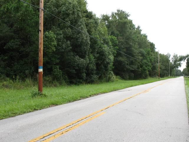
6 Volusia County MPO Bicycle and Pedestrian School Safety Review Study The conceptual plan shows several crosswalks that terminate into a curbed sidewalk; no ramps are shown. This may simply be a level of detail that will be addressed in the construction documents. If no ramps are planned, the School District may want to consider ramps to provide access. Finding: During the beginning of this Study, a nearly complete trail connection to the adjacent Forest Trace subdivision was discovered. Recommendation (Pending): Connect the existing trail through the conservation lot to the school district property and connect the school sidewalk system to this access point to provide a shorter route for students. This recommendation is under review by the developer, the City of DeLand and school district staff. Existing trail within Forest Trace Subdivision may provide an ideal connection to Elementary School Z Finding: There is no sidewalk along the east side of Hazen Road from New York Avenue (SR 44) to Minnesota Avenue. Specifically, a new residential development south of Minnesota Avenue (Mallory Square) does not provide a connecting sidewalk from the main entrance road, Little Torch Key Drive, to the sidewalk north of Hazen Road. Sidewalk money was contributed to county sidewalk fund in lieu of construction. The county plans to widen the road way in this area, but not to add sidewalks due to right of way constraints. Recommendation: Construct a minimum 5 wide sidewalk connecting this subdivision to the Minnesota Avenue sidewalk. This sidewalk is recommended as a priority project and is further discussed at the end of this chapter. Sidewalk along Hazen Road is missing from Little Torch Key Drive to Minnesota Avenue Chapter 3.6 Page 5


7 Elementary School Z Finding: The intersection of Hazen Road and Minnesota Avenue currently has a stop condition for motorists traveling on Hazen Road. The lack of a four-way stop at this intersection may increase the difficulty of crossing Minnesota Avenue for students walking or bicycling to and from school. Recommendation: Review this intersection for a four-way stop to reduce traffic speeds and provide traffic control to allow pedestrians and bicyclists a designated crossing. Provide crosswalks and signage in all directions. Review the need for a crossing guard at this location. The intersection of Hazen Road and Minnesota Avenue should be reviewed for a four-way stop Finding: There are no sidewalks along Hazen Road north of Plymouth Avenue and there are no sidewalks along Greens Diary Road. A newer development off Greens Dairy Road has internal sidewalks only. The students living along Hazen Road north of Plymouth Avenue and students living off Greens Dairy Road will not have a continuous sidewalk connection to school. Recommendation: Although the west side of Hazen Road (north of Plymouth Avenue) appears to have more right of way, a sidewalk should be constructed along the east side of Hazen in this area if possible. This placement will allow the sidewalk to line up with the Sidewalk is planned for the east side of Hazen from the school to Plymouth Avenue planned sidewalk on the east side of the road south of Plymouth Avenue. The planned crosswalk should connect these two sidewalks. Finding: Existing traffic along Plymouth Avenue appears to exceed the 40 miles per hour posted speed limit. Many trucks are traveling to the landfill located to the west of the school zone. An increase in traffic is expected with the opening of this school, the planned Spring to Spring Trail and the opening of a soccer complex in Recommendation: The County may wish to consider adding traffic calming devices to make motorists aware that they are entering an area with increased pedestrian and bicyclist A crossing guard is planned for the intersection of Hazen Road and Plymouth Avenue. Chapter 3.6 Page 6

8 Volusia County MPO Bicycle and Pedestrian School Safety Review Study activity. Wider sidewalks, landscaping, lower posted speeds, signage and enforcement may work together to increase the safety for sidewalk users in this area. The bicycle and pedestrian master plan for this Study proposes a wide sidewalk along the north side of Plymouth Avenue to connect the planned school to the planned soccer complex, the existing dog park and the planned Spring to Spring Trail. Finding: There is a sidewalk gap on the north side of Plymouth Avenue from Marjorie Rawlings Drive to just beyond the Liberty Baptist Church. The missing section of sidewalk may encourage students to cross Plymouth Avenue at areas other than the intersection of Hazen Road and Plymouth Avenue where a crossing guard is planned. Recommendation: Construct a sidewalk to fill in the gap in the sidewalk area. Provide a signed crosswalk at the intersection of Hazen Road and Plymouth Avenue address across from Hunters Creek Drive, located on the east side of Hazen Road. This project is recommended as a priority project and is reviewed further at the end of this chapter. There is a missing section of sidewalk along the north side of Plymouth Avenue Chapter 3.6 Page 7
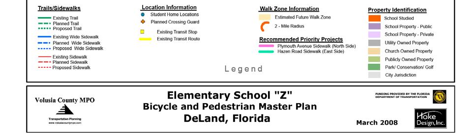
9 Elementary School Z Master Plan The following Bicycle and Pedestrian Master Plan specifies a network of sidewalks and trails that, if implemented, will greatly increase the convenience and safety of travel for pedestrians and bicyclists. A 24 x36 fold-out map is included as a deliverable with this Study. The Bicycle and Pedestrian Master Plan includes the following information: Existing Conditions: Existing Trails from County GIS and field review (solid green line) Existing Wide Sidewalk 6-8 from field review (solid blue line) Existing Sidewalks 3-5 from field review (solid red line) Existing Votran Routes from Volusia County MPO (yellow lines along roadway centerline). Planned Conditions: Planned Crossing Guard Location (orange cross) Planned State of Florida sidewalk and roadway improvements from FDOT website, State or County GIS (medium blue roadway centerline) Planned Volusia County sidewalk and roadway improvements from County GIS data (medium green roadway line) Planned trail (long dashed dark green line) Planned wide sidewalk (long dashed blue line) Planned sidewalk (long dashed red line) Recommendations of this Study: Estimated Potential Walk Zone (light tan) Proposed Trails (dashed dark green line) Proposed Sidewalks 6-8 wide (dashed blue line) Proposed Sidewalks 5 (dashed red line) Recommended Priority Projects (highlighted pink and blue) This Master Plan and supplemental information supplied within the Implementation Report are meant as a guideline for sidewalk and trail planning. The Master Plan is not an engineering document. Chapter 3.6 Page 8


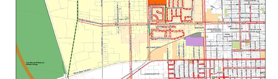
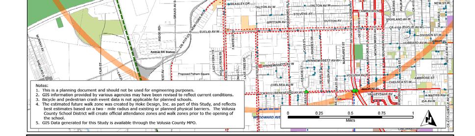
10 Volusia County MPO Bicycle and Pedestrian School Safety Review Study Chapter 3.6 Page 9
 School Served: Elementary School Z Maintaining Agency: Volusia County Finding: There is a sidewalk gap on the north side of Plymouth Avenue from Marjorie Rawlings Drive to just beyond the")

11 Recommended Priority Projects Elementary School Z Plymouth Avenue Sidewalk (north side) Project Location: Plymouth Avenue Project Description: 5-6 wide concrete sidewalk Estimated Cost: $190,000 ($95/LF) School Served: Elementary School Z Maintaining Agency: Volusia County Finding: There is a sidewalk gap on the north side of Plymouth Avenue from Marjorie Rawlings Drive to just beyond the Liberty Baptist Church. The missing section of sidewalk may encourage students to cross Plymouth Avenue at areas other than the intersection of Hazen Road and Plymouth Avenue where a crossing guard is planned. Recommendation: Construct a sidewalk to fill in the gap in the sidewalk area. Provide a signed crosswalk at the intersection of Hazen Road and Plymouth Avenue address across from Hunters Creek Drive, located on the east side of Hazen Road. Plymouth Avenue looking east to where sidewalk ends Other Information: Currently, there is a two-way stop at the intersection of Hazen Road and Plymouth Avenue, with through traffic on Plymouth Avenue. This intersection will be improved to include a four way stop when the school is opened. Plymouth Avenue looking west Plymouth Avenue looking east at Liberty Baptist Church Chapter 3.6 Page 10
 School Served: Elementary School Z Maintaining Agency: Volusia County Finding: There is no sidewalk along the east")
 does not provide a connecting sidewalk from the main entrance road, Little Torch Key Drive, to the sidewalk")
12 Volusia County MPO Bicycle and Pedestrian School Safety Review Study Hazen Road Sidewalk (east side) Project Location: The east side of Hazen Road from Minnesota Avenue to Little Torch Key Drive Project Description: 5-6 concrete sidewalk, 1000LF Estimated Cost: $95,000 ($95/LF) School Served: Elementary School Z Maintaining Agency: Volusia County Finding: There is no sidewalk along the east side of Hazen Road from New York Avenue (SR 44) to Minnesota Avenue. Specifically, a new residential development south of Minnesota Avenue (Mallory Square) does not provide a connecting sidewalk from the main entrance road, Little Torch Key Drive, to the sidewalk north of Minnesota Avenue. Recommendation: Construct a minimum 5 wide sidewalk connecting this subdivision to the existing sidewalk that terminates on the east side of Hazen Road, north of Minnesota Avenue. Consider making the intersection of Hazen Road with Minnesota Avenue a four-way stop. Hazen Road looking north toward the future school site Two stop signs at Minnesota Avenue emphasize the stop condition for motorists on Hazen Road Chapter 3.6 Page 11
Chapter 4.3 Enterprise Elementary. Volusia County MPO. March Page 7.0
 Chapter 4.3 Enterprise Elementary Enterprise, FL Volusia County MPO March 2008 Page 7.0 Volusia County MPO Bicycle and Pedestrian School Safety Review Study Introduction Enterprise Elementary School is
Chapter 3.3 Horizon Elementary School. Volusia County MPO. June 2009
 Chapter 3.3 Horizon Elementary School Port Orange, FL Volusia County MPO June 2009 Volusia County MPO School Bicycle and Pedestrian Review Study, Phase 3C School Summary Horizon Elementary School is located
Chapter 3.9 Timbercrest Elementary School. Volusia County MPO. November 2008
 Chapter 3.9 Timbercrest Elementary School Deltona, FL Volusia County MPO November 2008 Volusia County MPO School Bicycle and Pedestrian Review Study, Phase 3B School Summary Timbercrest Elementary School
Chapter 3.5 Osteen Elementary School. Volusia County MPO. November 2008
 Chapter 3.5 Osteen Elementary School Osteen, FL Volusia County MPO November 2008 Volusia County MPO School Bicycle and Pedestrian Review Study, Phase 3B School Summary Osteen Elementary School is located
CITY OF SOUTH DAYTONA
 CITY OF SOUTH DAYTONA FIVE YEAR WORK PLAN for HALF-CENT SALES TAX FY 2020-2025 Table of Contents Executive Summary Purpose of the Work Program... 3 Project List Magnolia Avenue North Roadway, Drainage
Hidden Oaks Elementary School
 Hidden Oaks Elementary School SCHOOL ROUTE PLAN For HIDDEN OAKS ELEMENTARY SCHOOL LOCATION 13 ORANGE COUNTY Prepared for: ORANGE COUNTY SCHOOL ASSESSMENT PROGRAM ORANGE COUNTY PUBLIC WORKS Traffic Engineering
Drag and drop pic and stretch/crop to the limits of the blue rectangle (delete this text box) Maxey Elementary School
 Maxey Elementary School") Drag and drop pic and stretch/crop to the limits of the blue rectangle (delete this text box) Maxey Elementary School SCHOOL ROUTE PLAN For MAXEY ELEMENTARY SCHOOL LOCATION 33 ORANGE COUNTY Prepared for:
Drag and drop pic and stretch/crop to the limits of the blue rectangle (delete this text box) Maxey Elementary School SCHOOL ROUTE PLAN For MAXEY ELEMENTARY SCHOOL LOCATION 33 ORANGE COUNTY Prepared for:
Public Information Meeting. Orange Camp Road. Dr. Martin Luther King Jr. Beltway to I-4. Presented by: Volusia County August 2, 2018
 Public Information Meeting Orange Camp Road Dr. Martin Luther King Jr. Beltway to I-4 Presented by: Volusia County August 2, 2018 1 Project Goals To improve the operations and safety for Orange Camp Road
July 5, Arthur R. Ware, Jr. Elementary School 2017 Safe Routes to School Walkabout Report
 July 5, 2017 Arthur R. Ware, Jr. Elementary School 2017 Safe Routes to School Walkabout Report 1 Walkabout Report Introduction On April 28, 2017, City, School, and SAWMPO staff met to conduct a Safe Routes
Chapter 4: Funding and Implementation
 Chapter 4: Funding and Implementation 83 84 Cost Estimating Cost estimating is an iterative process. When a project is in the conceptual stage, preliminary cost estimates are also provided conceptually,
APPENDIX A: Complete Streets Checklist DRAFT NOVEMBER 2016
 APPENDIX A: Complete Streets Checklist DRAFT NOVEMBER 2016 Complete Streets Checklist MetroPlan Orlando s Complete Streets Checklist is an internal planning tool for staff to further implementation of
Orange County s Transportation Planning and Multimodal Corridor Plan
 Orange County Transportation Planning Division Orange County s Transportation Planning and Multimodal Corridor Plan Presentation to UCF LIFE November 11, 2014 Alissa Barber Torres, Ph.D., AICP, PLS Presentation
SAFE ROUTES TO SCHOOL
 SAFE ROUTES TO SCHOOL Edgewood Elementary School Existing Conditions and ACTION PLAN > Oak Creek - Franklin Joint School District Table of Contents CONTEXT Enrollment Boundaries Enrollment
INTRODUCTION. Specifically, the objectives are to:
 INTRODUCTION The River to Sea Transportation Planning Organization (TPO) conducts the Tell the TPO Transportation Trends Survey to better understand the transportation preferences and priorities for the
FLORIDA DEPARTMENT OF TRANSPORTATION DISTRICT 7 DISTRICT WIDE BICYCLE/PEDESTRIAN ACCESS TO TRANSIT SAFETY ASSESSMENT AND IMPROVEMENT PLAN
 FLORIDA DEPARTMENT OF TRANSPORTATION DISTRICT 7 DISTRICT WIDE BICYCLE/PEDESTRIAN ACCESS TO TRANSIT SAFETY ASSESSMENT AND IMPROVEMENT PLAN TRANSIT SAFETY ASSESSMENT SR 55/US 19 AT 80 TH AVE N DRAFT JUNE
This page intentionally left blank.
 This page intentionally left blank. COMMUNITY Glenpool Community Overview Glenpool Glenpool is a city of nearly 12,000 residents located in Tulsa County southwest of Tulsa and Jenks. The city is growing
Chapter 2: Standards for Access, Non-Motorized, and Transit
 Standards for Access, Non-Motorized, and Transit Chapter 2: Standards for Access, Non-Motorized, and Transit The Washtenaw County Access Management Plan was developed based on the analysis of existing
F L E T C H E R A V E N U E
 Jan. 29, 2014 Introduction F L E T C H E R A V E N U E FDOT Local Agency Program (LAP) Project FPN: 428214-1-58-01 CIP 63090 Hillsborough County, Traffic Engineering, PWD Stake holders and partners are
Bicycle and Pedestrian Facilities Toolbox (Excerpt from Figure 3.1)
") Appendix B Neighborhood Connections Summaries This Appendix is a supplement to the information presented in Chapter 3 Connect People. The Appendix includes a summary or profile for each of the proposed
Appendix B Neighborhood Connections Summaries This Appendix is a supplement to the information presented in Chapter 3 Connect People. The Appendix includes a summary or profile for each of the proposed
Bicycle and Pedestrian Safety Review Study Implementation Report
 Bicycle and Pedestrian Safety Review Study Implementation Report Indian River Elementary school Edgewater, Florida March 2007 Hoke Design, Inc. Indian River Elementary School March 07 Hoke Design 1 Bicycle
CITY MANUALS AND STANDARDS REVIEW
 GEORGETOWN SIDEWALK MASTER PLAN CITY MANUALS AND STANDARDS REVIEW RESOURCES AND STANDARDS As part of the Master Plan process, a review and evaluation of current City documents and policies relevant to
Street Paving and Sidewalk Policy
 City Commission Policy 600 Street Paving and Sidewalk Policy DEPARTMENT: Public Works DATE ADOPTED: June 7, 1995 DATE OF LAST REVISION: December 10, 2014 Policy No. 600.01 AUTHORITY: PASS City of Tallahassee-Leon
City of Albert Lea Policy and Procedure Manual 4.10 ALBERT LEA CROSSWALK POLICY
 4.10 ALBERT LEA CROSSWALK POLICY PURPOSE: Pedestrian crosswalks are an integral part of our transportation infrastructure. To be effective and promote safety, marked crosswalks must be installed after
Pedestrian Safety Guide for Transit Agencies
 Pedestrian Safety Guide for Transit Agencies FDOT/FTPA/CUTR Professional Development Workshop June 15, 2010 1 Purpose Presentation Overview Bus Stop Location and Design Process/Partnership 2 Purpose Every
C/CAG. Sunnybrae Elementary School Walking and Bicycling Audit. San Mateo-Foster City School District JUNE 2013
 Sunnybrae Elementary School Walking and Bicycling Audit JUNE 2013 San Mateo-Foster City School District C/CAG City/County Association of Governments of San Mateo County SUNNYBRAE ELEMENTARY SCHOOL WALKING
NM-POLICY 1: Improve service levels, participation, and options for non-motorized transportation modes throughout the County.
 Transportation PRINCE WILLIAM COUNTY 2008 COMPREHENSIVE PLAN NON-MOTORIZED PLAN CONTENTS Goals, Policies, and Action Strategies Table 4 (Bike Facility Classifications and Descriptions) Table 5 (Bike Facility
Board of Supervisors February 27, 2017
 : Traffic Analysis Results & Draft Conceptual Plan Board of Supervisors February 27, 2017 Transportation Solutions Building Better Communities Presentation Overview Background Summary of Traffic Analysis
City of Richmond Bicycle Master Plan
 City of Richmond Bicycle Master Plan October 2011 Prepared by Fehr & Peers In association with Eisen Letunic City of Richmond Bicycle Master Plan October 2011 Prepared by Fehr & Peers In association with
This page intentionally left blank.
 This page intentionally left blank. COMMUNITY Coweta Community Overview Coweta Coweta, a residential community located in Wagoner County, is a suburb of Tulsa situated southeast of the metropolitan area
Fundamentals of Traffic Control Devices
 Fundamentals of Traffic Control Devices Traffic Engineering & Operations October 8, 2014 Raj Ponnaluri, Angela Wilhelm, and Christopher Lewis Agenda Agenda Signs Pavement Markings Signals Traffic Operations
ADA Transition Plan. City of Gainesville FY19-FY28. Date: November 5, Prepared by: City Of Gainesville Department of Mobility
 ADA Transition Plan FY19-FY28 Date: November 5, 2018 Prepared by: City Of Gainesville Department of Mobility 1.0 INTRODUCTION 1.1 BACKGROUND The federal statute known as the Americans with Disabilities
SAFE ROUTES TO SCHOOL
 SAFE ROUTES TO SCHOOL Forest Ridge Elementary School Existing Conditions and ACTION PLAN > Oak Creek - Franklin Joint School District Table of Contents CONTEXT Enrollment Boundaries
Plant City Walk-Bike Plan
 Plant City Walk-Bike Plan Plant City Commute Mode Share 2.2% 1.4% 2.9% Drove alone 10.2% Carpooled Public transportation (0.1%) Walked Used a Bike (0.4%) 82.9% Taxicab, motorcycle, or other means Worked
EXECUTIVE SUMMARY. Vision
 Vision Walking and bicycling in Salt Lake City will be safe, convenient, comfortable, and viable transportation options that connect people to places, foster recreational and economic development opportunities,
Improvements Infrastructure Gap Assessment and Improvements Street Striping
 Infrastructure Project Proposal The federal-aid Safe Routes to School program funds infrastructure/engineering projects that fall into two categories: Design (available only to School Development Authority
MASTER BICYCLE AND PEDESTRIAN PLAN
 VILLAGE OF NORTHBROOK MASTER BICYCLE AND PEDESTRIAN PLAN DRAFT PLAN OPEN HOUSE May 2, 2018 AGENDA 1. Community Engagement 2. Vision and Goals 3. General Structure of Plan 4. Recommendations Overview 5.
Pedestrian, Bicycle and Traffic Calming Strategic Implementation Plan. January 18, 2011
 Pedestrian, Bicycle and Traffic Calming Strategic Implementation Plan January 18, 2011 Tonight s Agenda Receive update on project Provide feedback on two policy issues Complete Streets Policy Project Prioritization
Pine Hills Road Pedestrian/Bicycle Safety Study Board of County Commissioners Work Session
 Pine Hills Road Pedestrian/Bicycle Safety Study Board of County Commissioners Work Session February 20, 2018 Meeting Agenda Study Overview Existing Conditions Access Management Potential Gateway Features
RZC Appendix 8A Marymoor Subarea Street Requirements
 RZC Appendix 8A Marymoor Subarea Street Requirements For additional design details for Marymoor Subarea infrastructure, refer to the 2017 Marymoor Subarea Infrastructure Planning Report. STREET REQUIREMENTS
Bikeway action plan. Bicycle Friendly Community Workshop March 5, 2007 Rochester, MN
 Bikeway action plan Summary The was held on March 5, 2007 at the Rochester Mayo Civic Center. The workshop was hosted by Rochester-Olmsted County Planning Department in collaboration with the League of
Pine Hills Road Pedestrian/Bicycle Safety Study Community Meeting #1
 Pine Hills Road Pedestrian/Bicycle Safety Study Community Meeting #1 June 8, 2017 Meeting Agenda Study Overview Community Survey Existing Conditions Access Management Potential Safety Countermeasures Potential
NEIGHBORHOOD TRAFFIC CALMING POLICY
 NEIGHBORHOOD TRAFFIC CALMING POLICY I. PURPOSE The City of Kent continually strives to strengthen and protect its neighborhoods by improving the quality of life in residential areas. Traffic conditions
6.0 PEDESTRIAN AND BICYCLE FACILITIES 6.1 INTRODUCTION 6.2 BICYCLE DEMAND AND SUITABILITY Bicycle Demand
 6.0 PEDESTRIAN AND BICYCLE FACILITIES 6.1 INTRODUCTION Bicycle and pedestrian travel along and in the vicinity of the corridor is part of the vision of Somerset and Hunterdon counties and the integrated
Transportation Policy Manual
 March 4, 2013 EXHIBIT 2 Metropolitan Transportation Planning Organization for the Gainesville Urbanized Area A Comprehensive Guide to Adopted Metropolitan Transportation Planning Organization for the
Borough of Danville, PA Traffic Calming Program Guidelines
 Borough of Danville, PA Traffic Calming Program Guidelines Adopted by Borough Council on 1 INTRODUCTION Speeding Traffic is a major concern in the Borough of Danville because of its detrimental impacts
BOARD OF COUNTY COMMISSIONERS AGENDA ITEM SUMMARY
 7B BOARD OF COUNTY COMMISSIONERS AGENDA ITEM SUMMARY PLACEMENT: REQUESTS AND PRESENTATIONS PRESET: TITLE: FLORIDA DEPARTMENT OF TRANSPORTATION (FDOT) PRESENTATION RECONSTRUCTION OF SR-76 (SW KANNER HIGHWAY)
Meadow Woods Elementary School
 Drag and drop pic and stretch/crop to the limits of the blue rectangle (delete this text box) Meadow Woods Elementary School Drag and drop pic and stretch/crop to the limits of the blue rectangle (delete
Transportation Planning Division
 Transportation Planning Division Presentation Outline Study Tasks Recap of Previous Meetings Data Collected Focus Areas within Study Limits Design Principles Tool Box Recommended Concepts Schedule Moving
Prince George s County plans, policies, and projects
 Prince George s County plans, policies, and projects Over 250 projects for trails, bikeways, designated bike lanes and sidewalk construction Trail projects that improve access to Metro Sidewalk and trail
SCHOOL ROUTE PLAN. For HUNTER S CREEK ELEMENTARY SCHOOL LOCATION 14 ORANGE COUNTY. Prepared for:
 SCHOOL ROUTE PLAN For HUNTER S CREEK ELEMENTARY SCHOOL LOCATION 14 ORANGE COUNTY Prepared for: ORANGE COUNTY SCHOOL ASSESSMENT PROGRAM ORANGE COUNTY PUBLIC WORKS Traffic Engineering Division 42 South John
Lynchburg District Update
 Lynchburg District Update Virginia Statewide Bicycle and Pedestrian Advisory Committee Spring Meeting May 16 th, 2017 David Cook Transportation Planner, VDOT Lynchburg District Table of Contents Active
Corpus Christi Metropolitan Transportation Plan Fiscal Year Introduction:
 Introduction: The Safe, Accountable, Flexible, Efficient Transportation Equity Act: A Legacy for Users (SAFETEA-LU) has continued the efforts started through the Intermodal Surface Transportation Efficiency
NJDOT Complete Streets Checklist
 Background The New Jersey Department of Transportation s Complete Streets Policy promotes a comprehensive, integrated, connected multi-modal network by providing connections to bicycling and walking trip
Houma-Thibodaux Metropolitan Planning Organization STP<200K Funding Application APPLICATION
 APPLICATION HOUMA-THIBODAUX METROPOLITAN PLANNING ORGANIZATION (HTMPO) FOR SURFACE TRANSPORTATION PROGRAM (STP
Traffic Impact Memorandum. May 22, 2018
 BISHOP PROFESSIONAL DEVELOPMENT BUILDING Proposed Land-use Change & Parking Modification 3601 SW 31st Street Topeka, Kansas 66614 CFS Project No. 185077 Traffic Impact Memorandum May 22, 2018 Prepared
CITY OF KASSON TRANSPORTATION ALTERNATIVES KASSON SAFE ROUTES TO SCHOOL
 ve ha 8t G B A Mantorville Ave N 240th Ave 16th St NE 11th Ave NE K-M HIGH SCHOOL SUNRISE TRAIL TO MANTORVILLE MNTH 57 SUNSET TRAIL TO MANTORVILLE NE PARK 16TH ST NE TRAIL K-M ELEMENTARY SCHOOL K-M MIDDLE
City of Sammamish. Welcome. Issaquah-Fall City Road Improvements Project Phase I Design: 242nd Avenue SE to Klahanie Drive SE
 Welcome Welcome to the third community meeting for the Issaquah-Fall City Road Improvements Project. AGENDA 6:00 p.m. Welcome and sign-in 6:10 p.m. Presentation 6:50 p.m. Open house Learn about the roadway
IMPLEMENTATION WORKBOOK
 Lawrence Township Bicycle and Pedestrian Planning Assistance Study IMPLEMENTATION WORKBOOK Final Action Plan - Part 2 April 2009 Prepared For: The Township of Lawrence and the New Jersey Department of
Markings Technical Committee Chapter 3H: Roundabout Markings APPROVED IN NCUTCD COUNCIL ON JANUARY 20, 2006
 ATTACHMENT NO. 30 Markings Technical Committee Chapter 3H: Roundabout Markings APPROVED IN NCUTCD COUNCIL ON JANUARY 20, 2006 Roundabouts are becoming an increasingly utilized form of intersection design
7/23/2017 VIA . Michael Hanebutt City of Sacramento Community Development Department 300 Richards Boulevard, 3 rd Floor Sacramento, CA 95811
 7/23/2017 VIA EMAIL Michael Hanebutt City of Sacramento Community Development Department 300 Richards Boulevard, 3 rd Floor Sacramento, CA 95811 RE: 65 th Street Apartments (DR17-220) Dear Mr. Hanebutt:
DISTRICT BICYCLE PROGRAM
 DISTRICT BICYCLE PROGRAM TxDOT Fort Worth District Public Hearing Bicycle Use on the State Highway System Public Hearing Agenda 1 2 3 4 5 6 Introduction Susan Howard TxDOT Public Involvement Specialist
Traffic Improvements for the Transit Oriented Development District (TODD) Meriden Public Library March 11, 2014
 Meriden Public Library March 11, 2014") Traffic Improvements for the Transit Oriented Development District (TODD) Meriden Public Library March 11, 2014 Project Overview Coordinate roadway improvements with other major projects HUB Flood Control
Traffic Improvements for the Transit Oriented Development District (TODD) Meriden Public Library March 11, 2014 Project Overview Coordinate roadway improvements with other major projects HUB Flood Control
Article 3.0 circulation plan
 Article 3.0 circulation plan Article 3.0 describes the existing circulation in the vicinity of the Plan Area, and illustrates the configuration of the surrounding roadway network. The proposed access and
Roadway Classification Design Standards and Policies. Pueblo, Colorado November, 2004
 Roadway Classification Design Standards and Policies Pueblo, Colorado November, 2004 Table of Contents Page Chapter 1. General Provisions 1.1 Jurisdiction 3 1.2 Purpose and Intent 3 1.3 Modification 3
Chapter 5 Future Transportation
 Chapter 5 Future Transportation The Future Land Use Plan identifies the desired land use designations. The land uses desired for Crozet depend, in large part, on the success of the transportation system,
Lee s Summit Road Improvement Study Public Open House June 7, 2007 Summary of Comment Card Responses
 Lee s Summit Road Improvement Study Public Open House June 7, 2007 Summary of Comment Card Responses Introduction At the Lee s Summit Road Improvement Study Public Open House held Thursday, June 7, 2007
Complete Streets Policy DAVID CRONIN, P.E., CITY ENGINEER
 Complete Streets Policy DAVID CRONIN, P.E., CITY ENGINEER Complete Streets City Commission adopted a Complete Streets policy in 2012 Complete Streets are road networks that are designed for all users:
PEDESTRIAN NETWORK PLAN
 GRAHAM PEDESTRIAN TRANSPORTATION PLAN Chapter 3 A 3.1 Overview new pedestrian network plan for the City of Graham has been developed based on an examination of the existing conditions (Chapter 2) and an
Clackamas County Comprehensive Plan
 ROADWAYS The County s road system permits the movement of goods and people between communities and regions, using any of a variety of modes of travel. Roads provide access to virtually all property. They
APPENDIX G: INTERSECTION NEEDS AT OKEECHOBEE BOULEVARD
 APPENDIX G: INTERSECTION NEEDS AT OKEECHOBEE BOULEVARD INTERSECTION NEEDS AT SR 7 and OKEECHOBEE BOULEVARD SR 7 Extension Project Development and Environment (PD&E) Study From Okeechobee Boulevard (SR
10A. DATE: October 5, Pedestrian and Bicycle Advisory Committee. Kevin Colin, Deputy Planning Manager Curt Bates, City Engineer
 10A DATE: October 5, 2016 TO: PREPARED BY: SUBJECT: Pedestrian and Bicycle Advisory Committee Kevin Colin, Deputy Planning Manager Curt Bates, City Engineer Discussion and Provide Comments, Associated
CURBSIDE ACTIVITY DESIGN
 5 CURBSIDE ACTIVITY DESIGN This chapter provides design guidance for separated bike lanes adjacent to curbside activities including parking, loading and bus stops. Typical configurations are presented
LANE ELIMINATION PROJECTS
 PRESENTATION OUTLINE Lane Elimination Considerations Districts 4 & 7 Draft Lane Elimination Processes FDOT Lane Elimination Guidelines Example Projects D4 Case Study: SR A1A (Ft. Lauderdale) D7 Case Study:
City of Birmingham Draft Multi-modal Transportation Plan
 City of Birmingham Draft Multi-modal Transportation Plan City Commission Public Hearing Monday, November 25, 2013 7:30 pm Norman Cox, PLA, ASLA The Greenway Collaborative, Inc. Ann Arbor, Michigan The
TRANSPORTATION ALTERNATIVES SET-ASIDE PROGRAM
 TRANSPORTATION ALTERNATIVES SET-ASIDE PROGRAM 2017 Call for Projects Recommendations for the North Central Texas Region Kevin Kokes Regional Transportation Council June 8, 2017 ELECTRONIC ITEM 4.1 FAST
Downtown Naples Mobility and Connectivity Study. Naples City Council Presentation January 2017
 Downtown Naples Mobility and Connectivity Study Naples City Council Presentation January 2017 Agenda 1. Introduction 2. Scope Review 3. Project Schedule 4. Existing Conditions 5. Public Charrette 6. Mobility
Mission-Geneva Transportation Study Community Workshop 2 July 8, 2006
 Community Workshop 2 July 8, 2006 Small Group Workbook 1 Basic Improvements on Mission Street Streetscape. Pedestrian-scale lighting; landscaping; community art on utility boxes; more (possibly unique)
Bicycle and Pedestrian Safety Review Study Assessment Report
 Bicycle and Pedestrian Safety Review Study Assessment Report Turie T. Small Elementary school Daytona Beach, Florida March 2007 Hoke Design, Inc. Turie T. Small Elementary School March 2007 Hoke Design,
Sarasota/Manatee MPO Project Priorities 2016 Adopted April 25, 2016
 All projects on the following priority lists should be implemented in the priority sequence listed, as consistent with the fiscal constraints identified in the MPO s adopted Long Range Transportation Plan
Broad Street Bicycle Boulevard Design Guidelines
 Broad Street Bicycle Boulevard Design Guidelines Building from the strategies introduced in the 2013 Bicycle Transportation Plan and community input received thus far, City Transportation Staff have identified
Implementing the Three Es of School Zone Traffic Calming
 Implementing the Three Es of School Zone Traffic Calming Use this evaluation tool as a guide to analyze the specific safety needs of your school. SCHOOL PROFILE School Name: School District: Address: Phone
RESOLUTION NO ?? A RESOLUTION OF THE CITY OF NEPTUNE BEACH ADOPTING A COMPLETE STREETS POLICY
 RESOLUTION NO. 2018-?? A RESOLUTION OF THE CITY OF NEPTUNE BEACH ADOPTING A COMPLETE STREETS POLICY WHEREAS, safe, convenient, and accessible transportation for all users is a priority of the City of Neptune
9/21/2016 VIA . RE: The Knot (DR16-270)
") 9/21/2016 VIA EMAIL Garrett Norman, Assistant Planner City of Sacramento Community Development Department 300 Richards Boulevard, 3 rd Floor Sacramento, CA 95811 RE: The Knot (DR16-270) Dear Mr. Norman:
9/21/2016 VIA EMAIL Garrett Norman, Assistant Planner City of Sacramento Community Development Department 300 Richards Boulevard, 3 rd Floor Sacramento, CA 95811 RE: The Knot (DR16-270) Dear Mr. Norman:
Bicycle Pedestrian Master Plan Pre Bid Meeting Portsmouth, NH August 15, 2013
 Bicycle Pedestrian Master Plan Pre Bid Meeting Portsmouth, NH August 15, 2013 2005 Master Plan GOAL: Provide for safe and convenient bicycle and pedestrian circulation throughout the City. Develop a city
Harford County Safe Walking to School Infrastructure Program. Jeff Springer, PE, AICP
 Harford County Safe Walking to School Infrastructure Program Jeff Springer, PE, AICP Goals Improve pedestrian safety for children walking to school in Harford County Implement a County-wide program to
Rolling Out New Bike Facilities Within the North Bethesda & White Flint Area
 Rolling Out New Bike Facilities Within the North Bethesda & White Flint Area Rolling Out New Bike Facilities Within the North Bethesda & White Flint Area Agenda Designing for all Cyclists Background on
Lincoln Highway Streetscape Plan Concept Plan
 Lincoln Highway Streetscape Plan Concept Plan November 14, 2014 Introduction This report provides a summary of conceptual transportation, land use, and design recommendations in the Lincoln Highway Streetscape
Golden Gate Park. Project Goal and Description. Lower Great Highway Facts
 PROJECT OVERVIEW Project Goal and Description The goal of the is to increase pedestrian safety and comfort along Lower Great Highway by evaluating and implementing near- and medium-term pedestrian improvements
Durrance Elementary School
 Durrance Elementary School SCHOOL ROUTE PLAN For DURRANCE ELEMENTARY SCHOOL LOCATION 9 ORANGE COUNTY Prepared for: ORANGE COUNTY SCHOOL ASSESSMENT PROGRAM ORANGE COUNTY PUBLIC WORKS Traffic Engineering
Item No. 14 Town of Atherton
 Item No. 14 Town of Atherton CITY COUNCIL STAFF REPORT CONSENT AGENDA TO: THROUGH: FROM: HONORABLE MAYOR AND CITY COUNCIL GEORGE RODERICKS, CITY MANAGER MICHAEL KASHIWAGI, COMMUNITY SERVICES DIRECTOR MARTY
MAG Town of Cave Creek Bike Study Task 6 Executive Summary and Regional Significance Report
 Page 1 MAG Town of Cave Creek Bike Study Task 6 Executive Summary and Regional Significance Report August 1, 2012 MAG Project #481 Page 2 Task 6 Executive Summary and Regional Significance Report Introduction
Trail Feasibility. 1. Introduction FINAL. October What s inside?
 VOLUSIA COUNTY MPO CITY OF PORT ORANGE FINAL Trail Feasibility October 2006 What s inside? 1 Introduction 2 Project Purpose & Scope 3 Physical Inventory & Assessment of Right-of- Way 4 Trail Concept Plan
12 RECOMMENDATIONS Road Improvements. Short Term (generally the next five years)
") 12 RECOMMENDATIONS Recommendations are based on the technical analysis of existing and future road and active transportation conditions, the results of the review of existing City policies and public feedback.
12 RECOMMENDATIONS Recommendations are based on the technical analysis of existing and future road and active transportation conditions, the results of the review of existing City policies and public feedback.
Route 28 Critical Locations Bicycling Network Connectivity November 2017
 Route 28 Critical Locations Bicycling Network Connectivity November 2017 Nobska Light Chatham Light Prepared by Cape Cod Commission staff on behalf of the Cape Cod Metropolitan Planning Organization and
11/3/2017 VIA . RE: River Oaks Phase 2 (P17-051)
") 11/3/2017 VIA EMAIL Ethan Meltzer, Assistant Planner City of Sacramento Community Development Department 300 Richards Blvd., 3 rd Floor Sacramento, CA 98811 RE: River Oaks Phase 2 (P17-051) Dear Mr. Meltzer:
11/3/2017 VIA EMAIL Ethan Meltzer, Assistant Planner City of Sacramento Community Development Department 300 Richards Blvd., 3 rd Floor Sacramento, CA 98811 RE: River Oaks Phase 2 (P17-051) Dear Mr. Meltzer:
Appendix T CCMP TRAIL TRAFFIC & TRANSPORTATION DESIGN STANDARD
 Appendix T CCMP 3.3.4 TRAIL TRAFFIC & TRANSPORTATION DESIGN STANDARD 3.3.4 Trail Traffic and Transportation Design Multi-use trails have certain design standards, which vary depending on the agency that
Windy Ridge Elementary School
 Windy Ridge Elementary School SCHOOL ROUTE PLAN For WINDY RIDGE ELEMENTARY SCHOOL LOCATION 54 ORANGE COUNTY Prepared for: ORANGE COUNTY SCHOOL ASSESSMENT PROGRAM ORANGE COUNTY PUBLIC WORKS Traffic Engineering
Chapter 13 ORANGE COVE
 Chapter 13 ORANGE COVE This chapter describes the current status and future plans for biking and walking in the City of Orange Cove. RELATIONSHIP TO CITY PLANS AND POLICIES The Orange Cove General Plan
Proposed. City of Grand Junction Complete Streets Policy. Exhibit 10
 Proposed City of Grand Junction Complete Streets Policy Exhibit 10 1 City of Grand Junction Complete Streets Policy Vision: The Complete Streets Vision is to develop a safe, efficient, and reliable travel
S A F E R O U T E S T O S C H O O L H E R M A N TOW N S C H O O L S A N D P R O C TO R S C H O O L S P L A N A P P R OVA L S
 S A F E R O U T E S T O S C H O O L H E R M A N TOW N S C H O O L S A N D P R O C TO R S C H O O L S P L A N A P P R OVA L S WHAT IS SAFE ROUTES TO SCHOOL? In 1969, nearly 50% of children walked or rode