DRAFT TENNYSON STREET ANGLED PARKING ANALYSIS
|
|
|
- Betty Goodman
- 6 years ago
- Views:
Transcription
1 DRAFT TENNYSON STREET ANGLED PARKING ANALYSIS Prepared for: City and County of Denver Department of Public Works, Engineering Division Traffic Engineering Services Parking Operations 201 W. Colfax Avenue, Department 508 Denver, CO Prepared by: Felsburg Holt & Ullevig 6300 South Syracuse Way, Suite 600 Centennial, CO / Project Manager: Jeffrey Ream, PE, PTOE Project Engineer: Ryan Germeroth, PE FHU Reference No October 2009
2 TABLE OF CONTENTS Page I. INTRODUCTION II. EXISTING CONDITIONS III. ANGLED PARKING ANALYSIS Option 1: Angled Parking Using Existing Roadway Width Option 2: Angled Parking on One Side of the Roadway Option 3: Angled Parking on One Side of the Roadway, Parallel on the Other Option 4: Angled Parking with 41 st and 42 nd Avenue designated as one-way streets Option 5: Higher Angled Parking on One Side of the Roadway, Parallel on the Other --15 IV. STUDY CONCLUSIONS AND RECOMMENDATIONS
3 LIST OF FIGURES Page Figure 1. Existing Conditions Figure 2. Option 1: Angled Parking Using Existing Road Width Figure 3. Option 2: Angled Parking on One Side and Widened Road Figure 4. Widened Road with Angled Parking on One Side, Parallel on the Other Figure 5. Park Intrusion into Chavez Park with Minimum-Depth Angled Parking Figure 6. Parking Conditions with Angled and Parallel Parking and One Way Streets Figure 7. Widened Road with Higher-Angle Parking on One Side, Parallel on the Other Figure 8. Park Intrusion into Chavez Park with Higher-Angle Parking LIST OF TABLES Page Table 1. Existing Parking Conditions Near Caesar Chavez Park Table 2. Parking Conditions with Angled Parking and Existing Road Width Table 3. Parking Conditions with Angled Parking on One Side and Widened Roads Table 4. Parking Conditions with Angled Parking on One Side and Parallel on the Other Table 5. Parking Conditions with Angled and Parallel Parking and One Way Streets Table 6. Parking Conditions with High-Angle Parking Along the Park and Parallel on the Opposite Side Table 7. Roadway Widening and Net Change in Spaces for Each Scenario
4 I. INTRODUCTION This report summarizes the feasibility study of providing angled parking in the vicinity of Caesar Chavez Park in the Tennyson Business District. Specifically, the study explored whether angled parking can be provided on Tennyson Street along the east side of the park, on 41 st Avenue along the south side of the park, along Utica on the west side of the park and on the south side of 42 nd Street east of Tennyson, opposite the park. Five potential angled parking options were explored for those blocks: Option 1: Layout angled parking using the existing curb-to-curb width on each road, determine the resulting increase or decrease in parking spaces in the area, and determine if the resulting road section provides sufficient through lane widths. Option 2: Layout angled parking using the minimum roadway width for parking on one side of the street only, determine the amount of intrusion into the pedestrian area (i.e., sidewalk and tree lawn) required to provide this width, and determine the resulting increase or decrease in parking spaces in the area. Option 3: Layout angled parking using the minimum roadway width for parking on both sides of the street (angled on one side, parallel on the other), determine the amount of intrusion into the pedestrian area required to provide this width, and determine the resulting increase or decrease in parking spaces in the area. Option 4: Layout angled parking using the using the existing curb-to-curb width on each road with 41 st Avenue and 42 nd Avenue designated as one-way streets, determine the resulting increase or decrease in parking spaces in the area, and determine if the resulting road section provides sufficient through lane widths. Option 5: Maximize the number of additional parking spaces provided by using a higher parking space angle (45 degrees) on all three sides of the park, and parallel parking on the opposite sides of the street, determine the amount of intrusion into the park required to provide this configuration, and determine the resulting increase or decrease in parking spaces in the area. The study also examined how many additional parking spaces would be provided by removing the mid-block pedestrian crossing on Tennyson between 41 st and 42 nd Avenues under the current parallel configuration and under the angled parking configuration. Page 3
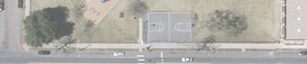
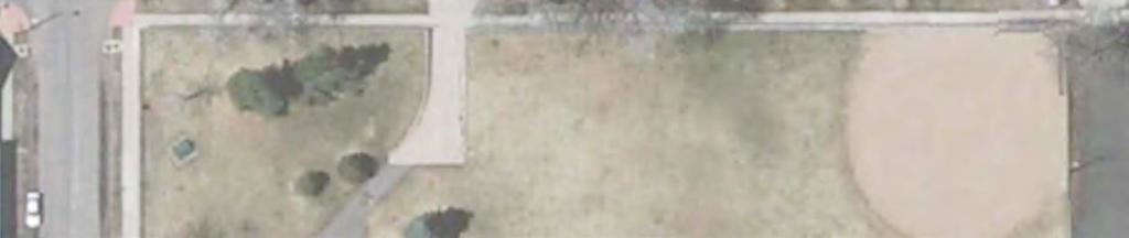
5 II. EXISTING CONDITIONS Figure 1 shows existing parking conditions in the vicinity of Caesar Chavez Park and Table 1 summarizes the parking lane, travel lane and total road width, along with the total number of parking spaces along each block face. The study area not only includes the blocks where angled parking would be provided but also includes the adjacent blocks, since it is necessary to remove some parking on those blocks to shift the travel lanes away from the angled parking. As indicated, there are currently 210 parking spaces along the block faces that would be impacted by the change to angled parking. It should also be noted that the current through lane widths on Utica, 41 st and 42 nd Avenues are less than the 11-foot minimum, but since these are both low volume, low speed local roadways there does not appear to be any compelling reason to widen them. By removing the mid-block pedestrian crossing on Tennyson between 41 st and 42 nd Avenues, two additional parking spaces could be provided on the west (park) side of the street and three on the east. Table 1. Existing Parking Conditions Near Caesar Chavez Park Parking Lane Thru Lane Roadway Parking Location From To Type Width Width Width Spaces 43rd Caesar Chavez Park Parallel 7' 11' 36' 4 Tennyson Southbound Park 41st Parallel 7' 11' 36' st 39th Parallel 7' 11' 36' 19 39th 41st Parallel 7' 11' 36' 18 Tennyson Northbound 41st 42nd Parallel 7' 11' 36' nd 43rd Parallel 7' 11' 36' 18 Tennyson Utica Parallel 7' 10' 34' st Westbound Utica Vrain Parallel 7' 10' 34' st Eastbound Vrain Tennyson Parallel 7' 10' 34' 20 Utica Northbound 41 st Park 15 parking/travel lane 30' 18 Utica Southbound Park 41st 15 parking/travel lane 30' 18 Tennyson Stuart 15 parking/travel lane 30' nd Eastbound Stuart Raleigh 15 parking/travel lane 30' nd Westbound Raleigh Tennyson 15 parking/travel lane 30' 20 Total Spaces Removing the mid-block pedestrian crossing would add two additional spaces to the total. 2. Removing the mid-block pedestrian crossing would add three additional spaces to the total. Page 4
6
7 III. ANGLED PARKING ANALYSIS Option 1: Angled Parking Using Existing Roadway Width Figure 2 shows the angled parking layout using the existing roadway widths and Table 2 summarizes the parking lane, travel lane, total road width and number of parking spaces along each block face for that condition. As indicated, while there would be five more spaces available along the park, the loss of parking in the transition blocks and on the opposite side of the streets means the angled parking layout would provide only 125 total spaces, or 85 less than the existing parallel configuration. Furthermore, a minimum travel lane width of 11 feet is required where angled parking is provided so vehicles have room to back out of the parking spaces, but none of the four roads are wide enough to provide that width (they are highlighted on the table), so it would not be possible to create angled parking using the existing roadways. It should also be noted that removing the mid-block pedestrian crossing on Tennyson between 41 st and 42 nd Avenues would provide enough room for three additional angled parking spaces on the west (park) side of the street. Table 2. Parking Conditions with Angled Parking and Existing Road Width Parking Lane Thru Lane Roadway Parking Location From To Type Width Width Width Spaces 43rd Park Parallel 7' 11' 36' 4 Tennyson Southbound Park 41st Angled 16' 10' 36' 19 1 (+3 spaces) 41st 39th Parallel 7' 11' 36' 19 39th 41st Parallel 7' 11' 36' 15 (-3 spaces) Tennyson Northbound 41st 42nd None 0 11' 36' 0 (-17 spaces) 42nd 43rd Parallel 7' 11' 36' 8 (-10 spaces) Tennyson Utica Angled 14' 10' 34' st Westbound 10 Utica Vrain Parallel 7' 10' 34' (-1 space) 41 st Eastbound Vrain Tennyson Parallel 7' 10' 34' 2 (-18 spaces) Utica Northbound 41 st Park Angled 14' 8' 30' 16 (-2 spaces) Utica Southbound Park 41 st Parallel 0 8' 30' 0 (-18 spaces) 42 nd Eastbound Tennyson Stuart Angled 14' 8' 30' 8 (-2 spaces) Stuart Raleigh 15 parking/travel lane 30' nd Westbound Raleigh Tennyson 15 parking/travel lane 30' 3 (-17 spaces) Total Spaces 125 (-85 spaces) 1. Removing the mid-block pedestrian crossing would add three additional spaces to the block (22 total). Highlight indicates insufficient thru lane width to allow vehicles to safely back out of angled spaces. Page 6
8
9 Option 2: Angled Parking on One Side of the Roadway Figure 3 shows the angled parking layout when the roadways are widened to the minimum required width, while Table 3 summarizes the parking lane, travel lane, total road width and number of parking spaces along each block face for that condition. As with Option 1, the layout would only provide 129 total spaces, or 81 less than existing parallel configuration, so the change would result in a significant loss of parking in the business district. Furthermore, to provide the required road width, the five-foot wide tree lawns along the east and south sides of park would need to be narrowed by between two and three feet, which would leave an area that is too narrow for any foliage, and the north tree lawn on 42 nd Avenue would need to be removed altogether. Widening Utica would require removing 6 feet of the 8.5-foot tree lawn along that side of the park, as well. As noted previously, removing the mid-block pedestrian crossing on Tennyson between 41 st and 42 nd Avenues would provide enough room for three additional angled parking spaces on the west (park) side of the street. Table 3. Parking Conditions with Angled Parking on One Side and Widened Roads Parking Lane Thru Lane Roadway Parking Location From To Type Width Width Width Spaces 43rd C.C. Park Parallel 7' 11' 36' 4 Tennyson Southbound C.C. Park 41st Angled 16' 4" 11' 38' 4" 19 1 (+2 4 ) (+3 spaces) 41st 39th Parallel 7' 11' 36' 19 39th 41st Parallel 7' 11' 15 (-3 spaces) Tennyson Northbound 41st 42nd None 0 11' See above 0 (-17 spaces) 42nd 43rd Parallel 7' 11' 8 (-10 spaces) 41 st Westbound Tennyson Utica Angled 14' 11' 36' (+2 ) 11 Utica Vrain Parallel 7' 10' 34' 10 (-1 space) 41 st Eastbound Vrain Tennyson Parallel 7' 10' See above 2 Utica Northbound 41 st Park Angled 14 11' 38' (+6 ) Utica Southbound Park 41 st Parallel 0 11' See above (-18 spaces) 20 (+2 spaces) 0 (-18 spaces) 8 (-2 spaces) 42 nd Eastbound 36' Tennyson Stuart Angled 14' 11' (+6 ) 30'-36 Stuart Raleigh 15 parking/travel lane 10 (+0 to 6 ) 42 nd Westbound Raleigh Tennyson 15 parking/travel lane See above 3 (-17 spaces) Total Spaces 129 (-81 spaces) 1. Removing the mid-block pedestrian crossing would add three additional spaces to the block (22 total). Page 8
10
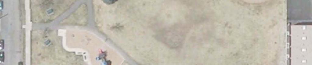
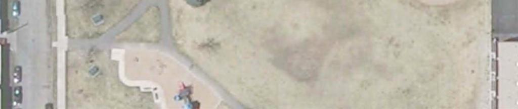
11 Option 3: Angled Parking on One Side of the Roadway, Parallel on the Other Figure 4 shows the angled parking layout when the roadways are widened to provide the minimum width required for angled parking along all three sides of the park and maintain the parallel parking on the opposite side. Table 4 summarizes the parking lane, travel lane, total road width and number of parking spaces along each block face for that condition and indicates that 213 total spaces are provided with parking on both sides of the road, which is only three more space than under the existing parallel configuration. This occurs because the spaces gained by providing angled parking is off-set by those lost in the set-back areas at the midblock crosswalk on Tennyson and on either end of each block. Furthermore, to provide the required road width, the tree lawns along the east and south sides of the park would need to be removed and the sidewalk narrowed to five feet; the tree lawn, sidewalk and three feet of the park would need to be removed along Utica; and the tree lawns on both sides of 42 nd Avenue would need to be removed. Figure 5 shows how this intrusion would affect the park. Removing the mid-block pedestrian crossing on Tennyson would provide enough room for three additional angled parking spaces on the west side of the street and three more parallel spaces on the east side (six total). Table 4. Other Parking Conditions with Angled Parking on One Side and Parallel on the Parking Lane Thru Lane Roadway Parking Location From To Type Width Width Width Spaces 43rd C.C. Park Parallel 7' 11' 36' 4 Tennyson Southbound C.C. Park 41st Angled 16-'4" 11' 46' 4" 19 1 (+10 4 ) (+3 spaces) 41st 39th Parallel 7' 11' 36' 19 39th 41st Parallel 7' 11' 18 Tennyson Northbound 41st 42nd None 0 11' See above nd 43rd Parallel 7' 11' st Westbound Tennyson Utica Angled 14' 10' 44' (+10 ) 11 Utica Vrain Parallel 7' 10' 34' st Eastbound Vrain Tennyson Parallel 7' 10' See above 20 Utica Northbound 41 st Park Angled 14 11' 45' 20 (+15 ) (+2 spaces) Utica Southbound Park 41 st Parallel 7 11' See above nd Eastbound 44' 8 Tennyson Stuart Angled 14' 11' (+16 ) (-2 spaces) 30'-44 Stuart Raleigh 15 parking/travel lane 10 (+0-16 ) 42 nd Westbound Raleigh Tennyson 15 parking/travel lane See above 20 Total Spaces 213 (+3 spaces) 1. Removing the mid-block pedestrian crossing would add three additional spaces to the block (22 total). 2. Removing the mid-block pedestrian crossing would add three additional spaces to the block (20 total). Page 10
12
13
14 Option 4: Angled Parking with 41 st and 42 nd Avenue designated as one-way streets Figure 5 shows the angled parking layout using the existing curb-to-curb width on 41 st and 42 nd Avenues when the roadways are designated as one-way streets. 43 rd Avenue north of the park would serve as 41 st Avenue s one way couplet and 41 st Avenue one block south on the east side of Tennyson would serve as 42 nd Avenue s one-way couplet. Utica would retain parallel parking on both sides of the street under this scenario to preserve the current roadway width there. Tennyson was not analyzed as a one-way street because there is no logical, nearby north-south street in the area that could serve as it s one-way couplet. Table 5 summarizes the parking lane, travel lane, total road width and number of parking spaces along each block face for that condition and indicates that 200 total spaces are provided, which is 10 less than under the existing parallel configuration because 42 nd Avenue is not wide enough to provide parallel parking on the north side opposite the angled spaces. Furthermore, there would be no net increase in spaces along the park because the angled configuration along 41 st Avenue provides the same number of spaces as the current parallel configuration. As with existing conditions, removing the mid-block pedestrian crossing on Tennyson would provide enough room for three additional parallel spaces on the west side of the street and three more parallel spaces on the east side (six total). Table 5. Parking Conditions with Angled and Parallel Parking and One Way Streets Parking Lane Thru Lane Roadway Parking Location From To Type Width Width Width Spaces 43rd C.C. Park Parallel 7' 11' 36' 4 Tennyson Southbound C.C. Park 41st Parallel 7' 11' 36' st 39th Parallel 7' 11' 36' 19 39th 41st Parallel 7' 11' 18 Tennyson Northbound 41st 42nd None 0 11' See above nd 43rd Parallel 7' 11' 18 Tennyson Utica Angled 14' 12' st North Side Utica Vrain Parallel 7' 10' 34' st South Side Vrain Tennyson Parallel 8' 12' Utica Northbound 41 st Park 15 parking/travel lane 30' 18 Utica Southbound Park 41st 15 parking/travel lane 30' 18 Tennyson Stuart Angled 16' 14' nd South Side Stuart Raleigh 15 parking/travel lane Raleigh Stuart 15 parking/travel lane nd North Side 0 Stuart Tennyson None (-10 spaces) Total Spaces 200 (-10 spaces) 1. Removing the mid-block pedestrian crossing would add three additional spaces to the total. 2. Removing the mid-block pedestrian crossing would add three additional spaces to the total. Page 13
15
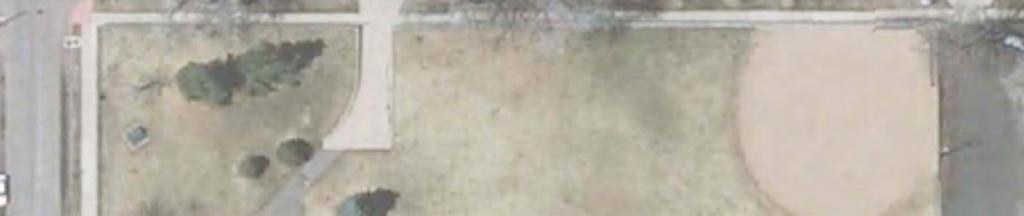
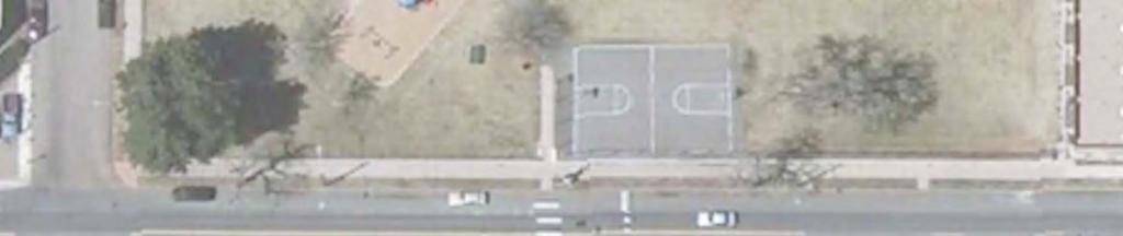
16 Option 5: Higher Angled Parking on One Side of the Roadway, Parallel on the Other Figure 6 shows the angled parking layout when the roadways are widened to maximize the number of angled parking spaces available along all three sides of the park and maintain the parallel parking on the opposite side. Table 6 summarizes the parking lane, travel lane, total road width and number of parking spaces along each block face for that condition and indicates that with steeper angle parking along the park, 226 total spaces are provided, or 16 more space than under the existing parallel configuration. However, significant intrusion into the park s amenities would be required to provide the required road width; Figure 7 shows that higherangle parking would shift the parking area and sidewalk into a portion of both the baseball diamond and the basketball court. Removing the mid-block pedestrian crossing on Tennyson would provide enough room for seven additional angled parking spaces on the west side of the street and three more parallel spaces on the east side (10 total). Table 6. Parking Conditions with High-Angle Parking Along the Park and Parallel on the Opposite Side Parking Lane Thru Lane Roadway Parking Location From To Type Width Width Width Spaces 43rd C.C. Park Parallel 7' 11' 36' 4 Tennyson Southbound C.C. Park 41st Angled 18' 7" 14' 51' 7" 20 1 (+15 7 ) (+4 spaces) 41st 39th Parallel 7' 11' 36' 19 39th 41st Parallel 7' 11' 18 Tennyson Northbound 41st 42nd Parallel 7 11' See above nd 43rd Parallel 7' 11' st Westbound Tennyson Utica Angled 18' 7" 14' (+17 7 ) (+6 spaces) Utica Vrain Parallel 7' 10' 34' st Eastbound Vrain Tennyson Parallel 7' 10' See above 20 Utica Northbound 41 st Park Angled 18' 7" 14 51' 7" 26 (+21 7 ) (+8 spaces) Utica Southbound Park 41 st Parallel 7 11' See above nd Eastbound 44' 8 Tennyson Stuart Angled 14' 11' (+16 ) (-2 spaces) 30'-44 Stuart Raleigh 15 parking/travel lane 10 (+0-16 ) 42 nd Westbound Raleigh Tennyson 15 parking/travel lane See above 20 Total Spaces 226 (+16 spaces) 1. Removing the mid-block pedestrian crossing would add seven additional spaces to the block (27 total). 2. Removing the mid-block pedestrian crossing would add three additional spaces to the block (20 total). Page 15
17
18
19 IV. STUDY CONCLUSIONS AND RECOMMENDATIONS Based on the analysis, Tennyson Street, 41 st Avenue, Utica Street and 42 nd Avenue in the vicinity of Caesar Chavez Park are all insufficient to allow for angled parking without some level of roadway widening. If the roads are widened to allow for angled parking on one side of the street only (by narrowing the tree lawn along the park and removing the north tree lawn along 42 nd Avenue), the net result would be an increase of five spaces in front of the park but a net loss of 80 parking spaces for the business district. If they are widened to allow for angled parking on one side and parallel parking on the other (by removing the tree lawns and narrowing/removing the sidewalks along the park, and removing both tree lawns on 42 nd Avenue), there would again be five more spaces along the park and the business district would have a net gain of three spaces over the current configuration. If 41 st and 42 nd Avenues are designated as one-way streets so they wouldn t need to be widened to provide angled parking, there would be no net gain in spaces along the park and a net loss of 10 spaces in the business district. If higher-angle parking is provided along the park there would be a net gain of 18 spaces along the park and 16 in the business district, but the parking area would intrude into both the baseball diamond and the basketball court. Table 7 summarizes the number of spaces gained or lost and the roadway widening required for each scenario. Table 7. Roadway Widening and Net Change in Spaces for Each Scenario Net Change Roadway Widening Required Scenario in Spaces Tennyson 41 st Street Utica Angled Parking Using Existing -85 Space Roadway Width (-82 w/o ped. crossing) 1 N/A2 N/A 2 N/A 2 Angled Parking on One Side, -81 Spaces No Parking on the Other (-78 w/o ped. crossing) Angled Parking on One Side, +3 Spaces Parallel Parking on the Other (+9 w/o ped. crossing) Angled Parking with One Way -10 Spaces Streets (-4 w/o ped. crossing) N/A N/A N/A High Angled Parking on One Side, +16 Spaces Parallel Parking on the Other (+26 w/o ped. crossing) Change in spaces if the pedestrian crossing on Tennyson between 41 st and 42 nd Streets is removed. 2. Without widening, these road would have insufficient thru lane width to allow vehicles to safely back out of angled spaces. Based on these results, there does not appear to be any significant benefit in providing angled parking, as maintaining or increasing the existing parking supply could only be accomplished by significantly impacting the pedestrian amenities in the vicinity of the park or intruding into the park itself. Page 18
FOCUS AREA 1 - Alberta Avenue Pocket Park 3 (121 Ave and 92 St)
") FOCUS AREA 1 - Alberta Avenue Pocket Park 3 (121 Ave and 92 St) New benches Plant evergreen trees Widen existing sidewalk from 1.5m to 1.8m Marked crosswalk 1.8m wide sidewalk Add pedestrian oriented lights
FOCUS AREA 1 - Alberta Avenue Pocket Park 3 (121 Ave and 92 St) New benches Plant evergreen trees Widen existing sidewalk from 1.5m to 1.8m Marked crosswalk 1.8m wide sidewalk Add pedestrian oriented lights
Addendum to Mitigated Negative Declaration
 Addendum Date: Case No.: 2014.1499E Project Title: (MDSP) - Mission Valencia Green Gateway Streetscape Project Original: 2008.1075, MDSP Mitigated Negative Declaration Project Sponsor: Charlie Ream, San
CITY OF LOS ANGELES INTER-DEPARTMENTAL MEMORANDUM
 CITY OF LOS ANGELES INTER-DEPARTMENTAL MEMORANDUM Date: April 1, 219 To: Honorable City Council c/o City Clerk, Room 395, City Hall Attention: Honorable Mike Bonin, Chair, Transportation Committee From:
Boston Post Road Design Feasibility Study
 Boston Post Road Design Feasibility Study Prepared for the City of Rye Final Report July 18, 2007 Prepared by: Buckhurst Fish & Jacquemart (BFJ) 115 Fifth Avenue New York, NY 10003 www.bfjplanning.com
Corporate. Report COUNCIL DATE: May 25, 1998 NO: R1500 REGULAR COUNCIL. TO: Mayor & Council DATE: April 27, 1998
 R1500 : Traffic Safety at 25 Avenue and 128 Street Intersection Corporate NO: R1500 Report COUNCIL DATE: May 25, 1998 REGULAR COUNCIL TO: Mayor & Council DATE: April 27, 1998 FROM: General Manager, Engineering
Figure 1: Vicinity Map of the Study Area
 ARIZONA TEXAS NEW MEXICO OKLAHOMA May 5, 2016 Mr. Anthony Beach, P.E. BSP Engineers 4800 Lakewood Drive, Suite 4 Waco, Texas 76710 Re: Intersection and Access Analysis along Business 190 in Copperas Cove
CURRENT ORIGINAL REFERENCE SECTIONS. (Typical Section) (Typical Section) The Parade Island Bay : Concept Option Summary Sheets.
 (Typical Section) The Parade Island Bay : Concept Option Summary Sheets.") ORIGINAL (Typical Section) CURRENT (Typical Section) 3,900 3,000 2,000 1,500 3,100 1,600 3,100 1,500 2,000 2,500 3,900 3,000 1,800 600 2,000 3,000 3,000 2,000 600 1,800 2,500 Existing Planting Traffic
ORIGINAL (Typical Section) CURRENT (Typical Section) 3,900 3,000 2,000 1,500 3,100 1,600 3,100 1,500 2,000 2,500 3,900 3,000 1,800 600 2,000 3,000 3,000 2,000 600 1,800 2,500 Existing Planting Traffic
Hennepin Avenue Reconstruction Washington Avenue to 12 th Street
 CITY OF MINNEAPOLIS Hennepin Avenue Reconstruction Washington Avenue to 12 th Street April 2016 1 Upcoming Opportunities Public Meeting #2 April 25, 2016 Minneapolis Central Library Doty Board Room Repeat
Shockoe Bottom Preliminary Traffic and Parking Analysis
 Shockoe Bottom Preliminary Traffic and Parking Analysis Richmond, Virginia August 14, 2013 Prepared For City of Richmond Department of Public Works Prepared By 1001 Boulders Pkwy Suite 300, Richmond, VA
Why invest in the 1 Street S.W. Corridor?
 Why invest in the 1 Street S.W. Corridor? This project is an investment in the Beltline Community and Calgary s economy. It is anticipated that The City s investment along this corridor will help with
Multi-Modal Traffic Analysis. Parisi and Associates
 Mill Valley to Corte Madera Bicycle and Pedestrian Corridor Study Appendix D: Multi-Modal Traffic Analysis Prepared by Parisi and Associates August 2009 Appendix D - Multi-Modal Traffic Analysis Table
C C C
 C-012-001 Thank you for your support for the creation of new public space and nonmotorized access between downtown and the waterfront through the Overlook Walk, the East-West Connections, and the Promenade.
MEMORANDUM. Charlotte Fleetwood, Transportation Planner
 MEMORANDUM Date: Updated August 22, 2017 To: Organization: Charlotte Fleetwood, Transportation Planner Boston Transportation Department From: Jason DeGray, P.E., PTOE, Regional Director of Engineering
Joshua Saak, P.E., PTOE Traffic Design Engineer Ada County Highway District May 23, 2013
 Joshua Saak, P.E., PTOE Traffic Design Engineer Ada County Highway District May 23, 2013 Creating Great Streets Through Road Diets and Conversions The Charlotte Experience Topics to Discuss Charlotte s
Providence Downtown Transit Connector STAKEHOLDER MEETING #2. Stakeholder Meeting #1 October 24, 2016
 Providence Downtown Transit Connector STAKEHOLDER MEETING #2 Stakeholder Meeting #1 October 24, 2016 February 2017 1 AGENDA 1 DTC Goals and Expectations 2 Street Design Concepts 3 Potential Benefits and
Downtown BRT Corridor Alternatives Review: 1 st, 2 nd, 3 rd and 4 th Avenue. Bus Rapid and Conventional Transit Planning and Design Services
 Downtown BRT Corridor Alternatives Review: 1 st, 2 nd, 3 rd and 4 th Avenue Bus Rapid and Conventional Transit Planning and Design Services City of Saskatoon February 2018 Project Team HDR Corporation
DRAFT. A fifth objective, other considerations, has been added to capture considerations not captured by the four primary objectives.
 TECHNICAL MEMORANDUM Albany - Washington Avenue Traffic Calming Evaluation Matrix of Conceptual Alternatives Date: May 17, 2017 Project #: 17356 To: Aleida Andrino-Chavez From: Laurence Lewis, Sara Muse,
Geneva-Harney Bus Rapid Transit Feasibility Study
 Geneva-Harney Bus Rapid Transit Feasibility Study Community Advisory Committee Meeting #6 Alternatives Update Baseline Concepts www.genevabrt.org Baseline Assumptions - Update Candlestick Point/Hunters
MoPac South: Impact on Cesar Chavez Street and the Downtown Network
 MoPac South: Impact on Cesar Chavez Street and the Downtown Network Prepared by: The University of Texas at Austin Center for Transportation Research Prepared for: Central Texas Regional Mobility Authority
Traffic Circulation & Pedestrian Safety Study
 Lyons Township High School North Campus La Grange, Illinois Parking Lot Vaughan Building N Main Building Prepared for: Prepared by: July 23, 2015 Contents List of Figures, iii 1. Introduction...1 2. Existing
Station 1: Street & Sidewalk Upgrades
 Station 1: Street & Sidewalk Upgrades Existing no left turn; Potential left turn arrow, see Circulation Study boards for more information Thru-lane guidance Improved lead-in green bike lane 17TH ST CASTRO
University Hill Transportation Study Technical Memorandum Alternatives Modeling and Analysis May 2007
 Technical Memorandum May 2007 Syracuse Metropolitan Transportation Council Edwards and Kelcey with Wallace Roberts and Todd Alta Planning and Design CONTENTS SECTION ONE- INTRODUCTION...1 SECTION TWO-
122 Avenue: 107 Street to Fort Road
 : 107 Street to Fort Road November 24, 2015 4:30 8:00 p.m. Meeting Purpose Summarize project work completed to date Share results of public input from Phase 1 Share the draft concept plan and proposed
2014/2015 BIKE ROUTE PLAN 83 AVENUE PROTECTED BIKE LANE
 About the Project The City of Edmonton is planning a major bike route on the southside of Edmonton. The Strathcona Bike Route will connect the communities of Strathcona, Garneau and the University area,
ALBERTA AVENUE WHAT WE HEARD REPORT BUILDING GREAT NEIGHBOURHOODS
 ALBERTA AVENUE WHAT WE HEARD REPORT BUILDING GREAT NEIGHBOURHOODS FEBRUARY 2019 EXECUTIVE SUMMARY Starting in 2019, Alberta Avenue will see the replacement and enhancement of its aging collector and local
Glenn Avenue Corridor Traffic Operational Evaluation
 Glenn Avenue Corridor Traffic Operational Evaluation PREPARED FOR: THE CITY OF AUBURN PREPARED BY: DECEMBER 2007 Glenn Avenue Corridor Study--Auburn, Alabama TABLE OF CONTENTS Introduction... 1 Background
Station Plan: Penn & 43rd Avenue
 Station Plan: Penn & 43rd Avenue This station will serve the northern portion of the Penn Avenue corridor, including the commercial node at 44th Avenue. Ridership and roadway geometry support station siting
King Soopers #116 Thornton, Colorado
 Traffic Impact Study King Soopers #116 Thornton, Colorado Prepared for: Galloway & Company, Inc. 1.0 EXECUTIVE SUMMARY King Soopers #116, a grocery marketplace anchored commercial development, is proposed
Rock Road Transit. Northwest Plaza. Charles Rock Rd. Shopping Center Woodson & St. Center
 35 Rock Road - Monday thru Friday EASTBOUND Effective: November 26, 2018 & Valley Industries 5:01A 5:07A 5:17A 5:28A 5:23A 5:30A 5:40A 5:51A 5:47A 5:54A 6:04A 6:16A 5:35A 5:41A 5:51A 5:58A 6:10A 6:17A
Monroe Street Reconstruction
 Total participants: 45+ Monroe Street Reconstruction Cross Section Workshop Notes September 29, 2016, Wingra School Workshop Orientation, Technical and Functional Considerations: The workshop began with
forwarddallas! Implementation Proposed Chapter 43 Code Amendment On-Street Parking
 forwarddallas! Implementation Proposed Chapter 43 Code Amendment On-Street Parking Transportation and Environment Committee Briefing December 10, 2007 PURPOSE Code amendment to establish regulations consistent
Main-McVay Transit Study: Phase 2 Options Definition and High Level Constraints Evaluation
 Main-McVay Transit Study: Phase 2 Options Definition and High Level Constraints Evaluation APRIL 2016 A collaborative study between: For Additional Information or to Comment If you would like additional
SAN FRANCISCO MUNICIPAL TRANSPORTATION AGENCY
 THIS PRINT COVERS CALENDAR ITEM NO.: 10.3 DIVISION: Sustainable Streets BRIEF DESCRIPTION: SAN FRANCISCO MUNICIPAL TRANSPORTATION AGENCY Approving various traffic and parking modifications on Bay Street
MEMORANDUM. Our project study area included the following locations:
 MEMORANDUM Date: To: From: Subject: Najib O. Habesch Nick M. Fomenko, PE, PTOE Bushnell Park North Traffic Assessment BETA Project #: 4461 As part of our contract to undertake the design of the Bushnell
Typical Cross Section: DOWNTOWN (Observer Highway - 8th Street)
") Typical Cross Section: DOWNTOWN (Observer Highway - 8th Street) DRAFT SEPTEMBER 23, 14 1 Washington Street Typical Block Downtown Typical Block: DOWNTOWN (Observer Highway - 8th Street) New crosswalks
Typical Cross Section: DOWNTOWN (Observer Highway - 8th Street) DRAFT SEPTEMBER 23, 14 1 Washington Street Typical Block Downtown Typical Block: DOWNTOWN (Observer Highway - 8th Street) New crosswalks
City of Seattle Edward B. Murray, Mayor
 City of Seattle Edward B. Murray, Mayor Department of Transportation Scott Kubly, Director Eastlake Community Council 117 E Louisa St. #1 Seattle, WA 98102-3278 January 28, 2016 RE: Roosevelt to Downtown
01. VICINITY OF GREENBRAE POC: EXISTING CONDITIONS
 01. VICINITY OF GREENBRAE POC: EXISTING CONDITIONS Existing Bus Stop Existing US101 On-ramp Existing POC Old Redwood Highway Rich Street City ROW Environmental Study Limit Industrial Way NO DESIGNATED
GENERAL. 1. Description
 GENERAL 1. Description This standard identifies minimum requirements that shall be met for all Bus Stops in the design and construction of elements for Arlington County Horizontal Design Standards. This
SAN FRANCISCO MUNICIPAL TRANSPORTATION AGENCY Order # 5883 FOR PUBLIC HEARING
 The Sustainable Streets Division of the San Francisco Municipal Transportation Agency will hold a public hearing on Friday, March 2, 2018, at 10:00 AM, in Room 416 (Hearing Room 4), City Hall, 1 Dr. Carlton
2014/2015 BIKE ROUTE PLAN 83 AVENUE PROTECTED BIKE LANE
 About the Project 2014/2015 BIKE ROUTE PLAN The City of Edmonton is planning a major bike route on the south side of Edmonton. This bike route is one part of a plan to provide citizens with transportation
Project Development & Environment (PD&E) Study. November 17, SR 90 (SW 8th Street and SW 7th Street) SW 8 th Street/SW 7 th Street PD&E Study 1
 Study. November 17, SR 90 (SW 8th Street and SW 7th Street) SW 8 th Street/SW 7 th Street PD&E Study 1") Financial Management Number: 432639-6-22-01 Federal Aid Project Number: 0202-054-P Efficient Transportation Decision Making Number: 14230 Project Development & Environment (PD&E) Study SR 90 (SW 8th Street
Financial Management Number: 432639-6-22-01 Federal Aid Project Number: 0202-054-P Efficient Transportation Decision Making Number: 14230 Project Development & Environment (PD&E) Study SR 90 (SW 8th Street
Saskatchewan Drive Roadway Rehabilitation and Shared-Use Path Widening
 Saskatchewan Drive Roadway Rehabilitation and Shared-Use Path Widening We are here today to present the draft plan for the Saskatchewan Drive Roadway Rehabilitation and Shared-Use Path Widening project
25th Avenue Road Diet Project A One Year Evaluation. Transportation Fund for Clean Air Project #05R07
 25th Avenue Road Diet Project A One Year Evaluation Transportation Fund for Clean Air Project #05R07 Submitted by: The San Francisco Municipal Transportation Agency Dan Provence May 22, 2009 EXECUTIVE
STONY PLAIN ROAD STREETSCAPE
 Jasper Place Revitalization Strategy: Vision The people involved in the Jasper Place Revitalization Strategy envision: Goal 1: Feeling safe in our community Create a community where feeling safe is common--where
Parisi TRANSPORTATION CONSUtllHG
 Attachment 1 To: Jonathan Goldman, P.E., QSD, CFM From: Cc: David Parisi, P.E., Curt Harrington, E.l.T. Andrew Davidson, P.E. Date: June 6, 2016 Subject: Bridgeway - Uncontrolled Crosswalk Tool and Location
Construction Staging Area Vaughan Road
 REPORT FOR ACTION Construction Staging Area - 109 Vaughan Road Date: May 25, 2017 To: Toronto and East York Community Council From: Acting Director, Transportation Services, Toronto and East York District
Everyone is a Pedestrian
 Everyone is a Pedestrian Improving Pedestrian Safety in Texas Transportation and Trinity River Project Committee 26 May 2015 Everyone is a Pedestrian Federal Highway Administration [ FHWA ] Programs to
CITY OF WEST LAKE HILLS. Forest View Neighborhood Traffic Calming Study
 CITY OF WEST LAKE HILLS 901 South Mopac Expressway Building V, Suite 220 Austin, Texas 78746 Texas P.E. Firm Registration No. F-929 Klotz Associates Final Report Submittal: March 20, 2015 Revised Final
EXECUTIVE SUMMARY. Page 1 of 6
 EXECUTIVE SUMMARY The purpose of this report is to identify conformance with the original traffic impact study for the proposed retail development on Lot 5 of Riverdale Retail Filing No. 1 located on the
East 12 th Street Bikeway Feasibility Study
 Final Report East 12 th Street Bikeway Feasibility Study Prepared for: City of Oakland Public Works Agency Submitted by: 180 Grand Avenue, Suite 250 Oakland, CA 94612 Phone: (510) 839-1742; Fax: (510)
Dra Design and Land Use Op ons Booklet
 Dra Design and Land Use Op ons Booklet March, 2015 This page was inten onally le blank. 2 Commercial-Vista Corridor Plan This booklet summarizes the street design and land use alterna ves for the Commercial
Complete Street Analysis of a Road Diet: Orange Grove Boulevard, Pasadena, CA
 Complete Street Analysis of a Road Diet: Orange Grove Boulevard, Pasadena, CA Aaron Elias, Bill Cisco Abstract As part of evaluating the feasibility of a road diet on Orange Grove Boulevard in Pasadena,
Mineral Avenue Corridor Assessment. ITE 2017 Western District Annual Meeting San Diego, CA June 21 st
 Mineral Avenue Corridor Assessment ITE 2017 Western District Annual Meeting San Diego, CA June 21 st Biography - Aaron Heumann, PE, PTOE Currently City of Littleton Transportation Engineering Manager 24
WEDNESDAY, SEPTEMBER 6, :00 PM City Council Chambers, 1 Civic Center Drive, San Marcos, CA 92069
 MINUTES Meeting of the San Marcos Traffic Commission WEDNESDAY, SEPTEMBER 6, 2017 6:00 PM City Council Chambers, 1 Civic Center Drive, San Marcos, CA 92069 CALL TO ORDER: Vice Chairman Rico called the
DEPARTMENT OF ENVIRONMENTAL SERVICES. North Harrison Street (Lee Highway to Little Falls Road) Comparative Analysis. Prepared for:
 Comparative Analysis. Prepared for:") DEPARTMENT OF ENVIRONMENTAL SERVICES North Harrison Street (Lee Highway to Little Falls Road) Comparative Analysis Prepared for: Arlington County Department of Environmental Services 2100 Clarendon Boulevard,
DEPARTMENT OF ENVIRONMENTAL SERVICES North Harrison Street (Lee Highway to Little Falls Road) Comparative Analysis Prepared for: Arlington County Department of Environmental Services 2100 Clarendon Boulevard,
Aurora Urban Street Standards For Transit Oriented Developments and Urban Centers
 Aurora Urban Street Standards For Transit Oriented Developments and Urban Centers I. Purpose These standards will be applied to create a safe, comfortable, pleasant and pedestrian-friendly multi-modal
CAPE COD COMMISSION 3225 MAIN STREET P.O. BOX 226 BARNSTABLE, MA (508) Fax (508) Transportation Safety Report
 Fax (508) Transportation Safety Report") CAPE COD COMMISSION 3225 MAIN STREET P.O. BOX 226 BARNSTABLE, MA 02630 (508) 362-3828 Fax (508) 362-3136 2006 Transportation Safety Report Bourne: Otis Rotary Harwich: Route 137/Route 39 Orleans: Route
CAPE COD COMMISSION 3225 MAIN STREET P.O. BOX 226 BARNSTABLE, MA 02630 (508) 362-3828 Fax (508) 362-3136 2006 Transportation Safety Report Bourne: Otis Rotary Harwich: Route 137/Route 39 Orleans: Route
Date: April 4, Project #: Re: A Street/Binford Street Traffic/Intersection Assessment
 To: Peter Cavanaugh General Electric From: David Bohn, PE Ryan White, PE Date: April 4, 217 Project #: 13421. Re: / Traffic/Intersection Assessment Consistent with the Cooperation Agreement between the
CLOSED. Highlights of the Final Concept Design:
 The final Concept Design is the result of many months of listening, learning, creating, balancing, and understanding different needs and viewpoints, as well as incorporating technical requirements and
Co-ordinator Transportation Committee. Director, Mobility Services and Corporate Fleet Services Environment and Transportation Department
 28 REGIONAL MUNICIPALITY OF OTTAWA-CARLETON MUNICIPALITÉ RÉGIONALE D OTTAWA-CARLETON REPORT RAPPORT Our File/N/Réf. Your File/V/Réf. 25 23-97-R016 DATE 15 April 1997 TO/DEST. FROM/EXP. SUBJECT/OBJET Co-ordinator
AGENDA ITEM 6 D THOMASVILLE ROAD (HERMITAGE BOULEVARD TO LIVE OAK PLANTATION ROAD) ROADWAY SAFETY AUDIT
 ROADWAY SAFETY AUDIT") May 15, 2018 AGENDA ITEM 6 D THOMASVILLE ROAD (HERMITAGE BOULEVARD TO LIVE OAK PLANTATION ROAD) ROADWAY SAFETY AUDIT TYPE OF ITEM: Discussion STATEMENT OF ISSUE The Florida Department of Transportation
May 15, 2018 AGENDA ITEM 6 D THOMASVILLE ROAD (HERMITAGE BOULEVARD TO LIVE OAK PLANTATION ROAD) ROADWAY SAFETY AUDIT TYPE OF ITEM: Discussion STATEMENT OF ISSUE The Florida Department of Transportation
133 rd Street and 132 nd /Hemlock Street 132 nd Street and Foster Street MINI ROUNDABOUTS. Overland Park, Kansas
 133 rd Street and 132 nd /Hemlock Street 132 nd Street and Foster Street MINI ROUNDABOUTS Overland Park, Kansas September 1, 2017 TABLE OF CONTENTS 1. INTRODUCTION... 1 2. LITERATURE REVIEW... 1 3. CONCEPT
Dear Mr. Tweed: Sincerely, Min Zhou, P.E. Vice President
 December 17, 2012 Mr. Steve Tweed City of Long Beach, Department of Public Works Traffic & Transportation Bureau, 10 th Floor City Hall 333 West Ocean Boulevard Long Beach, CA 90802 Subject: Broadway and
FY 2006 TRANSPORTATION CAPITAL PROGRAM
 Airport Circle Elimination, CR 563, 646 S9820 Intersection, operational, and safety improvements at the intersection of Tilton Road (CR 563) and Delilah Road (CR 646) will include elimination of the circle,
Improving Cyclist Safety at the Dundas Street West and Sterling Road Intersection
 STAFF REPORT ACTION REQUIRED Improving Cyclist Safety at the Dundas Street West and Sterling Road Intersection Date: August 17, 2012 To: From: Wards: Reference Number: Public Works and Infrastructure Committee
Conversion of One-Way Couplet Streets to Two-Way
 Conversion of One-Way Couplet Streets to Two-Way May 5, 2016 Oklahoma Traffic Engineers Association 2016 Spring Meeting, Tulsa, OK Kevin St. Jacques, P.E., PTOE, PTP Freese and Nichols Overview Initial
CITY OF OAKLAND. 27th Street Bikeway Feasibility and Design. Final Report (v3) March 23, Kimley-Horn and Associates, Inc.
 March 23, Kimley-Horn and Associates, Inc.") CITY OF OAKLAND 27th Street Bikeway Feasibility and Design Final Report (v3) March 23, 2007 PREPARED BY: Kimley-Horn and Associates, Inc. Table of Contents 1. Introduction 3 2. 27 th Street/Bay Place Corridor
CITY OF OAKLAND 27th Street Bikeway Feasibility and Design Final Report (v3) March 23, 2007 PREPARED BY: Kimley-Horn and Associates, Inc. Table of Contents 1. Introduction 3 2. 27 th Street/Bay Place Corridor
Interstate Route 77 / US Route 62 / State Route 687 (Fulton Road) Transportation Improvement Project. Prepared September 6, 2017
 Transportation Improvement Project. Prepared September 6, 2017") EODOT Project: ODOT Project: STA-IR 77-.50; PID 00290 Interstate Route 77 / US Route 62 / State Route 687 (Fulton Road) Transportation Improvement Project Summary of Public Comments Received and Responses
EODOT Project: ODOT Project: STA-IR 77-.50; PID 00290 Interstate Route 77 / US Route 62 / State Route 687 (Fulton Road) Transportation Improvement Project Summary of Public Comments Received and Responses
OTTAWA TRAIN YARDS PHASE 3 DEVELOPMENT CITY OF OTTAWA TRANSPORTATION IMPACT STUDY. Prepared for:
 OTTAWA TRAIN YARDS PHASE 3 DEVELOPMENT CITY OF OTTAWA TRANSPORTATION IMPACT STUDY Prepared for: The Ottawa Train Yards Inc. 223 Colonnade Road South, Suite 212 Nepean, Ontario K2E 7K3 January 17, 2012
Recommendations. Central Salem Mobility Study
 Central Salem Mobility Study The Central Salem Mobility Study evaluated a range of multimodal transportation issues affecting downtown Salem, including circulation, access, and safety for people traveling
TRAFFIC ASSESSMENT River Edge Colorado
 TRAFFIC ASSESSMENT River Edge Colorado Submitted by: Fehr & Peers 621 17th Street, Ste. 231 Denver, CO 8293 (33) 296-43 December, 21 App. M-2 Traffic Assessment River Edge Colorado December 21 TABLE OF
OFFICE/RETAIL DEVELOPMENT 1625 BANK STREET OTTAWA, ONTARIO TRANSPORTATION BRIEF. Prepared for: Canada Inc.
 OFFICE/RETAIL DEVELOPMENT 1625 BANK STREET OTTAWA, ONTARIO TRANSPORTATION BRIEF Prepared for: 9402209 Canada Inc. December 15, 2015 115-625 Report_2.doc D. J. Halpenny & Associates Ltd. Consulting Transportation
Memorandum. Sunday, July 13, Saturday, July 19, 2014
 Memorandum To: David Lowin, Brooklyn Bridge Park Corporation From: Daniel Schack, AICP, PTP Date: Re: Brooklyn Bridge Park Pier 5/6 Loop Road Traffic Study Project No: 14-01-2407 At the request of Brooklyn
TRAFFIC ACTION PLAN. Laurie Meadows Neighborhood CITY OF SAN MATEO
 TRAFFIC ACTION PLAN Laurie Meadows Neighborhood CITY OF SAN MATEO Draft January 2017 Table of Contents Introduction... 2 The Traffic Forum Process... 5 Neighborhood Traffic Issues... 7 Neighborhood Recommendations
Meadow Woods Elementary School
 Drag and drop pic and stretch/crop to the limits of the blue rectangle (delete this text box) Meadow Woods Elementary School Drag and drop pic and stretch/crop to the limits of the blue rectangle (delete
CRESTON ROAD COMPLETE AND SUSTAINABLE STREETS CORRIDOR PLAN
 CRESTON ROAD COMPLETE AND SUSTAINABLE STREETS CORRIDOR PLAN Preferred Plan Community Presentation September 27, 2017 City of El Paso de Robles in partnership with: Local Government Commission, W-Trans,
City of El Cerrito San Pablo Avenue Specific Plan. Capital Improvement Program
 City of El Cerrito San Pablo Avenue Specific Plan Capital Improvement Program May 2015 San Pablo Avenue Intersection Improvements San Pablo Avenue and Hill Street/Eastshore Boulevard Background Existing
5. MODIFICATIONS AT JEANNE D ARC BOULEVARD/REGIONAL ROAD 174 INTERCHANGE INTERSECTION - PUBLIC HEARING COMMITTEE RECOMMENDATION
 5. MODIFICATIONS AT JEANNE D ARC BOULEVARD/REGIONAL ROAD 174 INTERCHANGE INTERSECTION - PUBLIC HEARING COMMITTEE RECOMMENDATION Having held a public hearing, that Council approve the preliminary designs
Chapter 3: Multi-Modal Circulation and Streetscapes
 CHAPTER 3: MULTI-MODAL CIRCULATION AND STREETSCAPES Chapter 3: Multi-Modal Circulation and Streetscapes Overview Streetscape improvements have already been completed for Depot Street between Main Avenue
ARTINSVILLE ENRY OUNTY REA RANSPORTATION TUDY
 ARTINSVILLE ENRY OUNTY REA RANSPORTATION TUDY DEVELOPED BY THE TRANSPORTATION AND MOBILITY PLANNING DIVISION OF THE VIRGINIA DEPARTMENT OF TRANSPORTATION IN COOPERATION WITH THE U.S. DEPARTMENT OF TRANSPORTATION,
David DiPierro, John Amberson. Steering Committee Meeting #4 Overview
 IBI GROUP 18401 Von Karman Avenue Suite 110 Irvine CA 92612 USA tel 949 833 5588 fax 949 833 5511 ibigroup.com Memorandum To/Attention Steering Committee Members Date February 17, 2016 From IBI Group Project
180 Grand Avenue, Suite x117 Dowling Associates, Inc.
 180 Grand Avenue, Suite 250 510.839.1742 x117 Oakland, CA 94612 510.839.0871 fax www.dowlinginc.com mbowman@dowlinginc.com Dowling Associates, Inc. Date: Memorandum To: CC: From: Ms. Leah Greenblat City
BENNING ROAD & BRIDGES TRANSPORTATION IMPROVEMENTS CRASH DATA AND SAFETY ANALYSIS TECHNICAL MEMORANDUM DRAFT MAY 2016
 BENNING ROAD & BRIDGES TRANSPORTATION IMPROVEMENTS CRASH DATA AND SAFETY ANALYSIS TECHNICAL MEMORANDUM DRAFT MAY 2016 This page left intentionally blank. Table of Contents 1.0 Introduction... 1 1.1 Crash
Purpose: Financial Implications and Impact Statement: It is estimated that the cost to implement:
 Various Modifications Lower Jarvis Street and Lake Shore Boulevard East; Lower Jarvis Street, east side, between Lake Shore Boulevard East and The Esplanade - 45-77 Lower Jarvis Street; and Lower Jarvis
Flatbush Avenue
 7.2.1.7 Flatbush venue Flatbush venue is one of the major traffic arteries in the study area and its efficient operation is an important ingredient in owntown rooklyn s management plan. While it currently
San Jose Transportation Policy
 San Jose Transportation Policy Protected Intersections in LOS Policies to Support Smart Growth Presented by: Manuel Pineda City of San Jose Department of Transportation Bay Area Map San Francisco Oakland
ALLEY 24 TRAFFIC STUDY
 ALLEY 24 TRAFFIC STUDY in City of Frostburg, Maryland January 2013 3566 Teays Valley Road Hurricane, WV Office: (304) 397-5508 www.denniscorporation.com Alley 24 Traffic Study January 2013 Frostburg, Maryland
Route 47 (North Main Street) Reconstruction
 Reconstruction") TOWN OF SUNDERLAND Route 47 (North Main Street) Reconstruction Presented by Lou Rabito, P.E. Presented to Town of Sunderland June 11, 2018 Project Overview MassDOT Project No. 607245 Resurfacing and Related
TOWN OF SUNDERLAND Route 47 (North Main Street) Reconstruction Presented by Lou Rabito, P.E. Presented to Town of Sunderland June 11, 2018 Project Overview MassDOT Project No. 607245 Resurfacing and Related
Lincoln Avenue Road Diet Trial
 Lincoln Avenue Road Diet Trial Data Collection Report June 1, 2015 Department of Transportation Table of Contents I. Introduction...... 3 II. Data Collection Methodology & Results...... 5 A. Traffic Volume
Retrofitting Urban Arterials into Complete Streets
 Retrofitting Urban Arterials into Complete Streets John N. LaPlante, P.E., P.T.O.E., T.Y. Lin International Prepared for: Illinois Traffic Engineering & Safety Conference Urbana, Illinois October 18, 2007
CAPITOL DRIVE & FOND DU LAC AVENUE INTERSECTION ANALYSIS. Urban Planning 772 SARAH BREGANT, RYAN PETERSON, & MATT WERDERITCH
 CAPITOL DRIVE & FOND DU LAC AVENUE INTERSECTION ANALYSIS Urban Planning 772 SARAH BREGANT, RYAN PETERSON, & MATT WERDERITCH OVERVIEW N 51 ST BOULEVARD N 51 ST BOULEVARD 12,100 44,700 W CAPITOL DRIVE 52,600
TENW Transportation Engineering NorthWest
 DRAFT FOR CLIENT REVIEW ONLY TENW Transportation Engineering NorthWest MEMORANDUM DATE: August 22, 2017 TO: FROM: SUBJECT: Patrick Yamashita City of Mercer Island Chris Forster, P.E. TENW Trip Generation
Memo. Ocean Avenue Corridor Design Project Public Workshop #2 Summary
 Ocean Avenue Corridor Design Project Public Workshop #2 Summary The second public workshop for the Ocean Avenue Corridor Design Project was held on Wednesday, May 14, 2014 from, 6 to 8 pm at Lick Wilmerding
Scarlett Road Bridge & Road Improvements Lambton Park Community School - Gymnasium Tuesday November 28 th, 2017
 Scarlett Road Bridge & Road Improvements Lambton Park Community School - Gymnasium Tuesday November 28 th, 2017 PROJECT LOCATION 2 SCARLETT ROAD BRIDGE Constructed in 1912, the bridge carries 4 active
Transportation Impact Study for Abington Terrace
 Transportation Impact Study for Abington Terrace Abington Township, Montgomery County, PA Sandy A. Koza, P.E., PTOE PA PE License Number PE059911 Prepared by McMahon Associates, Inc. 425 Commerce Drive,
WELCOME. Stakeholder Involvement Group Meeting #2 Round Lake Public Works October 24, 2018
 WELCOME Stakeholder Involvement Group Meeting #2 Round Lake Public Works October 24, 2018 MEETING AGENDA 1. Welcome and Introductions 2. Study Progress Update 3. Problem Statement 4. Technical Analysis
Neighborhood Pedestrian Safety and Traffic Calming Study
 Neighborhood Pedestrian Safety and Traffic Calming Study for the area bounded by Foster Avenue, Bedford Avenue, Farragut Road and Ocean Avenue Flatbush, Brooklyn, New York prepared by Michael King, miking@trafficcalmer.com
Reference number /VP. Lafayette Downtown Congestion Study - Additional Traffic Analysis
 To James Hinkamp and Tony Coe, City of Lafayette Date January 19, 2017 Copies Reference number 243381/VP From Michael Iswalt and Vanessa Peers File reference 4-05 Subject Lafayette Downtown Congestion
Road Diets FDOT Process
 Florida Department of TRANSPORTATION Road Diets FDOT Process Humberto Castillero, PE, PTOE Roadway Design Office Purpose of Guide Develop a statewide lane elimination review process Balance state & local
Bicycle Traffic Control Signal - St. Clair Avenue West and Poplar Plains Road
 PW17.11 REPORT FOR ACTION Bicycle Traffic Control Signal - St. Clair Avenue West and Poplar Plains Road Date: November 4, 2016 To: Public Works and Infrastructure Committee From: Acting General Manager,