BLOOMFIELD GATEWAY AND STREETSCAPE IMPROVEMENT PLAN
|
|
|
- Adam Wells
- 5 years ago
- Views:
Transcription

1 BLOOMFIELD GATEWAY AND STREETSCAPE IMPROVEMENT PLAN December 22, 2009 PREPARED BY: with Wilbur Smith Associates, Transporation Planners PREPARED FOR: Bloomfield Development Corporation PROJECT FUNDING BY: Offi ce of Senator Ferlo
2 THIS PAGE LEFT INTENTIONALLY BLANK

3 PROJECT INTRODUCTION AND BACKGROUND Home to one of Pittsburgh s largest and most active business districts along Liberty Avenue, Bloomfield, also known as Little Italy, attracts visitors not only from nearby neighborhoods but from the entire Pittsburgh region. The community has much to offer in its shops, Italian markets, restaurants, and beyond. Proud of their heritage, residents who represent generations of families are deeply rooted in the community, and will be an important factor in creating and implementing a successful plan for the Bloomfield Gateway and Streetscape Improvement project. The Bloomfield Development Corporation, through a CDCP Grant and funding from the Office of Senator Ferlo and Mainstreets Pittsburgh, is seeking to improve four sites within the commercial corridor along Liberty Avenue in the Bloomfield neighborhood of the City of Pittsburgh. These sites include Liberty Avenue between 40th Street and the Bloomfield Bridge intersection; the current Shur Save grocery store site; the Bloomfield Bridge Intersection; and Liberty Avenue between Mathilda Street and Millvale Avenue in front of West Penn Hospital. In each area identified, this study focuses on enhancing the streetscape with special attention to improving pedestrian safety and traffic flow. This study also seeks to establish these areas as prominent gateways and portals to the Bloomfield business district corridor. Consideration of the Little Italy theme has been incorporated where possible. ASSUMPTIONS Any development alternative beyond a replacement project will probably require the need for a parking garage to meet parking requirements for the use (Assume $40k per space below grade, $30k per space above grade deck) Any additional development on site will probably not meet the bulk requirements The prime marketable edges are: Liberty Ave, Howley Ave, and Ella (to the corner of Liberty) Any chosen path of development will require a full, in-depth traffic study The NW corner of the Shur Save site will remain residential Any chosen development will require a community review, planning review and design review Any major gesture at the Mathilda / Millvale section of Liberty will require a larger coordination effort between the business owners and the hospital Any major gesture to improve the flow at the Bloomfield Bridge intersection should be pursued only after a full, in depth traffic study of that area and in coordination with the City of Pittsburgh
4 THIS PAGE LEFT INTENTIONALLY BLANK
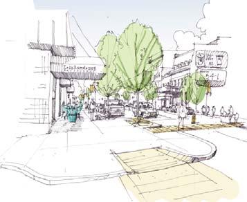
 to provide a gateway and streetscape improvement plan for four sites along Liberty Avenue, the main street of Bloomfield.")

5 FEEDBACK / COMMUNITY INPUT / PROJECT PROCESS PROCESS Burt Hill and transportation consultant, Wilbur Smith Associates, provided preliminary design services for the Bloomfield Development Corporation (BDC) to provide a gateway and streetscape improvement plan for four sites along Liberty Avenue, the main street of Bloomfield. This project included a number of community stakeholders as part of the design process. The client, a committee of the Bloomfield Development Corporation, the Community Design Center of Pittsburgh, Senator Ferlo s Office, Mainstreets Pittsburgh, business owners, and members of the community helped to define the direction of the study. Public input was incorporated throughout the process. Burt Hill conducted 3 meetings with the BDC Committee between June and August 2009 to discuss design issues. Burt Hill and Wilbur Smith presented their concepts to the Bloomfield community at 2 public meetings. Project Committee Meetings were held on: June 25, 2009 July 23, 2009 August 13, 2009 Community Meetings were held on: June 30, 2009 August 25, 2009 PROJECT GOALS Public Presentation at West Penn Hospital Community Feedback Example Create new Gateway Improve Identity of Bloomfield s Main Street Pedestrian Safety Improvements Aesthetic Improvements Maximize On-Street Parking Define street parking through design elements Maintain Existing Curbs Reduce traffic congestion Incorporate Bike Lanes Re-knit Existing Building Fabric of Upper and Lower Liberty Ave.
6 THIS PAGE LEFT INTENTIONALLY BLANK


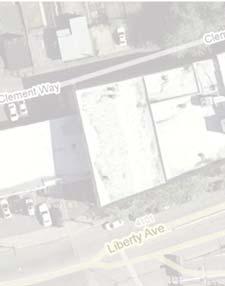
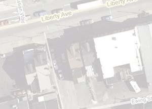
7 SITE I & II SHUR SAVE PARCEL AND THE INTERSECTION OF THE BLOOMFIELD BRIDGE, LIBERTY AVE, MAIN STREET, & HOWLEY STREET


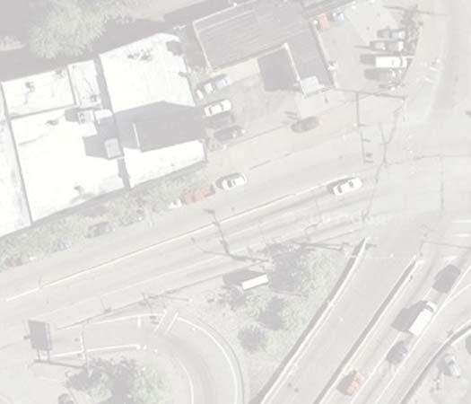
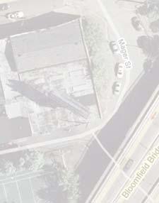
8 SITE I & II - SITE CONTEXT AND ANALYSIS View towards Bloomfield Bridge View towards lower Liberty Ave. CONSTRAINTS OPPORTUNITIES View inbound along oversized Howley Ave. Underutilized traffic lanes - Main St. spur & Liberty Ave. curb side merge lanes. Too much pavement - Heat Island Effect with dark asphalt pavement. Limited trees are planted. Unsightly utility poles and wires exist. Illegal or unsafe street parking occurs. Merging lanes backs up traffic. Long distance, illdefined pedestrian crossings. Damaged pavement at center of lanes. Howley is a one way street only northbound. Generous width of sidewalks to accommodate new trees and new urban furniture. Retail & commercial typical at street level to blend with existing context. Plenty of pedestrians with mix of visitors and neighbors. Create a stronger identity. Introduce better pedestrian lighting. Introduce consistent banners for events. Reknit upper and lower Liberty through developing Shur Save site. Eliminate Main Street spur to increase development parcel of Shur Save site and re-knit building fabric of Liberty Ave.

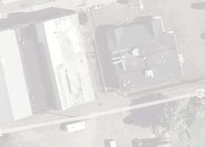
9 SITE I - SITE CONTEXT AND ANALYSIS Longitudinal Liberty Street section of proposed development with existing context. Development will reknit the building fabric of upper and lower Liberty Avenue Development opportunities at Site I - Shur Save Parcel +16 Site I Shur Save Site - Existing grade slopes from Ella Street towards the intersection of Liberty Avenue and Main Street. This allows for an opportunity to place parking access from Howley Street and possibly Gangwish Street. Building massing opportunities at Site I - Shur Save Parcel


10 SITE I - DEVELOPMENT CONCEPT 1 (PREFERRED SOLUTION) SITE I - DEVELOPMENT CONCEPT 2 Plan Plan Section Development option with ground floor retail along Liberty Ave, select serice hotel above, grocery store, townhomes facing existing housing fabric. Multilevel parking deck with access from Howley St. and Gangwish St. Bring development parcel and building edge to the sidewalk at Liberty Avenue where the Main Street Spur lane once existed. This is the highest and best use of the property. Development option with ground floor retail and upper level condominiums fronting public greenspace area along Liberty Ave. Bring development parcel and building edge to the sidewalk at Liberty Avenue where the Main Street spur lane once existed. Grocery store at corner of Liberty Ave. and Ella Street. Parking deck is required to accommodate off-street parking requirements. Section


11 SITE I - DEVELOPMENT CONCEPT 3 SITE I & II - ZONING ANALYSIS Existing site is a parking lot and a stand-alone grocery store View toward Shur Save Grocery Store along Howley Street. Note no street trees and one way northbound. Plan Grade change along Main Street spur Landscaped island serves as gateway into Bloomfield neighborhood. Section Development option with ground floor retail and upper level apartments fronting public greenspace area along Liberty Ave. Bring development parcel and building edge to the sidewalk at Liberty Avenue where the Main Street Spur lane once existed. Grocery store at corner of Liberty Ave. and Ella Street. Surface parking provided. This is not a highest and best use of the property but does incorporate added uses in addition to the grocery store fronting the main street. Address scale of existing housing fabric on Gangwish Street.
. Eliminates the Main St.")
12 SITE II - INTERSECTION CONCEPT 1 (PREFERRED SOLUTION) SITE II - INTERSECTION CONCEPT 2 BUMP-OUT PLAN This plan concept incorporates the following opportunities: Decrease the crossing distance for pedestrians by shortening crosswalk distance. Decreases drive lanes along Liberty Ave. due to perceived underutilized lanes (Right inbound and outbound lanes). Eliminates the Main St. Spur in front of the Shur Save site. Improves crosswalk indicators/painting. Reduces illegal parking by defining parking locations with curb bump-outs. Remove corner curb cut at Gulf Gasoline Station to allow for pedestrian crosswalk (must be coordinated with parcel owner). Proposal to turn Howley St. into two-way street to Gangwish St., then one way only from Gangwish northbound. Improve lane designation of Main Street. Additional street trees helps to green Liberty Ave. No changes to Bloomfield Bridge. BOULEVARD PLAN This plan concept incorporates the following opportunities: Decrease the crossing distance for pedestrians by shortening crosswalk distance. Decreases drive lanes along Liberty Ave due to underutilized lanes (Right inbound and outbound lanes). Eliminates the Main St. Spur in front of the Shur Save site. Improves crosswalk indicators/painting. Remove corner curb cut at Gulf Station to allow for pedestrian crosswalk (must be coordinated with parcel owner). Proposal to turn Howley St. into two-way street to Gangwish St., then one way only from Gangwish northbound. Improve lane designation of Main Street. No change to Bloomfield Bridge. The boulevard scheme includes trees along the sidewalks and down the center median of the streets. This scheme introduces street parking only permitted at certain times of the day, most likely during off-peak traffic.
 and shorten crosswalk distance for pedestrians (2).")

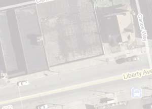
13 8 SITE I & II - FINAL CONCEPT 7 TOWNHOMES PARKING GARAGE Aerial Image of Site I & Site II 5 RETAIL GROUND LEVEL HOTEL UPPER LEVELS 6 2 GROCERY STORE 25K SF 3a 4 3a 4 3b 3b ELLA ST. Streetscape improvements include the following: new curb bump-outs define parking spaces (1) and shorten crosswalk distance for pedestrians (2). Replace parking meters with more efficient pay and display system, place utility lines underground, provide new urban furniture including benches, trash containers, bike racks, and combined signal/light poles in lieu of existing cobra-head lights. Bus shelters should be placed in appropriate locations to prevent conflicts with visibility. Reinforce and high-light bike lanes inbound and outbound west of Bloomfield Bridge intersection (3a). Repaint combined traffic/bike sharrow lane markings east of Bloomfield Bridge intersection (3b). Street trees with a vehicle-friendly canopy are to be planted throughout the Liberty Ave. corridor (4). Crosswalks may be raised/textured and visible with new reflective paint and signage. Eliminate the Main St. Spur in front of the Shur Save Grocery Store site thus increasing development opportunities and relinking the building fabric of upper and lower Liberty Avenue (5). Reduce corner curb cut at Gulf Gasoline Station to allow for pedestrian crosswalk (must be coordinated with parcel owner) (6). Proposal to turn Howley St. into two-way street to Gangwish St. (7), then one way only from Gangwish St. northbound (8).


14 SITE II - BEFORE AND AFTER STREET SECTIONS 20 +/- SIDEWALK DRIVE Outbound DRIVE Outbound TURN Inbound DRIVE Inbound DRIVE Inbound MAIN STREET SPUR SIDEWALK SIDEWALK DRIVE Outbound DRIVE Outbound DRIVE / TURN Inbound DRIVE PARKING Inbound SIDEWALK EXISTING STREET SECTION AND PARTIAL PLAN OF LIBERTY AVE. Existing street conditions are as follows - 2 outbound lanes, 2 inbound lanes, 1 inbound turn lane to Bloomfield Bridge, 1 single Main Street Spur towards Main Street from Bloomfield Bridge intersection. Perceived underutilized right lanes due to merging traffic outbound and inbound. No street parking adjacent Bloomfield Bridge intersection on Liberty Ave. until east of Ella Street or west of Main Street for both inbound and outbound traffic. PROPOSED STREET SECTION AND PARTIAL PLAN OF LIBERTY AVE. Proposed street improvements are as follows - 2 outbound lanes and 2 inbound lanes, one of which will serve as a turning lane onto the Bloomfield Bridge. Elliminate the underutilized Main Street Spur to allow for additional real estate to develope the Shur Save Site Parcel and to better define and link future building fabric with both Upper and Lower Liberty Ave. This will depend on the city vacating their Right of Way. Provide street parking along inbound lane. Additional street trees help to green the street. Indicate combined drive/bike sharrow lanes.


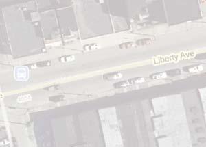
15 SITE I & II - BEFORE & AFTER CONCEPT PERSPECTIVES Existing view inbound towards Main St. Spur and landscaped island at image center. Existing view outbound towards Bloomfield Bridge intersection and Shur Save Grocery Store. Proposed view inbound along Liberty Ave. to intersection adjacent new street fronting grocery store. Proposed view from lower Liberty Ave. outbound towards the Bloomfield Bridge Intersection.

16 SITE I & II - COMPARISON CHART & ZONING ANALYSIS


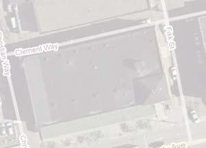
17 SITE III UPPER LIBERTY AVENUE - S. MATHILDA STREET TO S. MILLVALE AVENUE

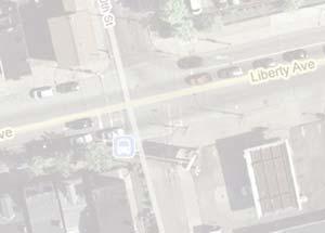
18 SITE III - SITE CONTEXT AND ANALYSIS COMMERCIAL COMMERCIAL COMMERCIAL CONSTRAINTS Limited trees are planted. Unsightly & exposed utility poles and wires. Illegal or unsafe street parking. Sharrow bike lane markings are worn out and need repainted. Traffic queues at intersections due to double parked vehicles. Long pedestrian crosswalks. Illegal parking and spaces at intersections impairs sight distance especially for left turns. Sunoco corner curb-cut is close to intersection and is a safety concern. OPPORTUNITIES Increase vehicular visibility turning onto Liberty Ave. from Mahtilda and Millvale. Define parking and West Penn Hospital drop-off with bump-out curbcuts. Generous width of sidewalks to accommodate new trees and new urban furniture. Create a stronger identity. Introduce better pedestrian lighting. Introduce consistent banners for events. Position urban street furniture to add to the character of the Bloomfield Main Street.
.")
.")
19 SITE III - FINAL CONCEPT 1 Streetscape improvements include the following: new curb bump-outs define parking spaces (1), the drop-off location at West Penn Hospital s Liberty entrance (2), and shorten crosswalk distance for pedestrians (3). Replace parking meters with more efficient pay and display system (4), remove utility lines and place underground, provide new urban furniture including benches, trash containers, bike racks, and combined signal/light poles in lieu of existing cobra-head lights. Bus shelters should be placed in appropriate locations to prevent conflicts with visibility (5). Repaint combined drive/bike sharrow lane markings (6). Additional street trees with a vehicle-friendly canopy are to be planted throughout the Liberty Ave. corridor (7). Crosswalks may be raised/textured and made visible with new bright/reflective painting and on-street signage (8) Aerial Image of Site III
20 SITE III - BEFORE AND AFTER STREET SECTIONS SIDEWALK PARKING DRIVE / BIKE Outbound DRIVE / BIKE Inbound PARKING SIDEWALK SIDEWALK PARKING DRIVE / BIKE Outbound DRIVE / BIKE Inbound PARKING SIDEWALK EXISTING STREET SECTION AND PARTIAL PLAN OF LIBERTY AVE. Single drive lane in each direction shared with bicycle traffic. Limited street trees. Metered parking both sides of street. PROPOSED STREET SECTION AND PARTIAL PLAN OF LIBERTY AVE. Keep single lane traffic in each direction. Defined parking by bump-out curb cuts, introduce pay & display parking to maximize on-street parking, add street trees to both sidewalk and bump-out locations. Indicate combined drive/bike sharrow lanes with fresh paint and improved signage.


21 SITE III - BEFORE & AFTER CONCEPT PERSPECTIVES Existing view inbound of West Penn Hospital Liberty Ave. entry. Existing street trees and parking spaces impairing view from Mahtilda towards Liberty Ave. Proposed view inbound towards West Penn Hospital drop-off Zone. Proposed bump-out at S. Mathilda / Liberty Intersection to improve visibility and pedestrian safety.
22 THIS PAGE LEFT INTENTIONALLY BLANK


23 SITE IV LOWER LIBERTY AVENUE - 40TH STREET TO THE BLOOMFIELD BRIDGE INTERSECTION

24 SITE IV - SITE CONTEXT AND ANALYSIS CONSTRAINTS Traffic speed at 40th Street intersection is dangerous combined with change in street elevation. Limited trees are planted. Unsightly utility poles and wires exist. Illegal or unsafe street parking occurs. Merging & turn lanes back up traffic at rush hours. Crosswalks have faded markings. OPPORTUNITIES Generous width of sidewalks to accommodate new trees and new urban furniture. Retail & commercial typical at street level to blend with exising context. Plenty of pedestrians with mix of visitors and neighbors. Create a stronger identity. Introduce better pedestrian lighting. Introduce consistent signage or banners for neighborhood events. Opportunity to provide zones for permanent parking. Outdoor dining opportunities at wide sidewalks.
, remove utility lines and place underground, provide new urban furniture including benches, trash containers, bike racks, and")
.")
25 SITE IV - FINAL CONCEPT Streetscape improvements include the following: New curb bump-outs define parking spaces and shorten crosswalk distance for pedestrians (1). Replace parking meters with more efficient pay and display system (2), remove utility lines and place underground, provide new urban furniture including benches, trash containers, bike racks, and combined signal/light poles in lieu of existing cobra-head lights. Bus shelters should be placed in appropriate locations to prevent conflicts with visibility (3). Repaint bike lane markings (4). Additional street trees with a vehicle-friendly canopy are to be planted throughout the Liberty Ave. Corridor (5). Crosswalks may be raised/textured and made visible with new bright/reflective painting and on-street signage (6). Aerial Image of Site IV


26 SITE IV - BEFORE AND AFTER STREET SECTIONS SIDEWALK PARKING DRIVE DRIVE PARKING SIDEWALK SIDEWALK PARKING BIKE DRIVE DRIVE BIKE PARKING SIDEWALK EXISTING STREET SECTION AND PARTIAL PLAN OF LIBERTY AVE. Limited street trees. Metered parking both sides of street. Bike lane is not well defined. PROPOSED STREET SECTION AND PARTIAL PLAN OF LIBERTY AVE. Coordinate single lane traffic in each direction. Define parking with bump-out curb cuts, introduce pay & display parking to maximize on-street parking, add street trees to both sidewalk and bump-out locations. Indicate bike lanes with paint and improved signage.


27 SITE IV - BEFORE & AFTER CONCEPT PERSPECTIVES Existing view inbound/north west at Liberty Ave. and Canoe Way Existing view outbound/east at Liberty Ave. and Canoe Way View of new crosswalk, bump-out, street trees and bike lane at Liberty Ave. and Canoe Way View north along Liberty Ave. adjacent future development along street edge with outdoor dining, new street trees, and new automobile/pedestrian light poles with banners.


28 SITE IV - ADDITIONAL DESIGN OPPORTUNITIES Existing view east of baseball field entrance before Bloomfield Bridge on-ramp. Existing views of underutilized coblestone spaces adjacent to Bloomfield Bridge along Liberty Ave. Improve design of cobblestone areas adjacent Bloomfield Bridge / park entrance with new trees, bushes and groundcover. Introduce public art and pedestrian lighting. Improve access and signage to the new baseball field just south of Liberty Ave. by way of public art and improved pedestrian lightning.
29 GENERAL COST OF IMPROVEMENTS General Road and Sidewalk Improvements Cost $ Unit Milling and Repaving Road Surface 45 SY Concrete Sidewalks 60 SY Concrete Curb 50 LF Concrete Curb ADA Ramps 1,000 EACH Utility Relocations Manholes (grade adjustment) 1,000 EACH Utility Relocations Vaults (minor) 2,500 EACH Utility Relocations - Water & Sewer 120 LF Drainage Bicycle Safe Grate Inlet 3,000 EACH Pavement Markings (bike lane) 6 LF Street Signage - New 30 LF Street Signage - Relocate 10 LF Streetscaping - New Tree & Pit 500 EACH Streetscaping - Nurture Existing Tree 200 EACH Streetscaping - Bus Shelter 6,000 EACH Streetscaping - Bike Racks 1,500 EACH Streetscaping Components per Block 25,000 BLOCK Streetscaping Components per Intersection 10,000 INTERSECTION Light Poles - 15' Pedestrian 8,000 EACH Light Poles - 30' Street 9,500 EACH (includes foundation, poles, luminaires) Traffic Resignalization 225,000 INTERSECTION (includes hardware, controller, detection) All work is to be considered preliminary and not for construction purposes. Field dimensional verification and review of all applicable zoning, building and other municipal codes should be reviewed before final recommendations can be made. Additional costs will include Maintenance & Protection of Traffic, Mobilization, Construction Inspections, Consultation During Construction and Contingency Costs. Comperable to Penn Avenue Reconstruction Unit Cost Estimate +/ Our preliminary streetscape improvement cost estimate per the recommendations outlined in this report is between $250k to $950k.


30 MISCELOUS IMPROVEMENT IMAGES Street trees, pedestrian crosswalk, street lighting and upgraded pavement Streetscape improvements via building signage Pay and display parking machine Bump-out curb cut along Forbes Ave. in Oakland Bike lane marking Public Art streetscape improvements Street level storefront transparency and building signage and lighting improves public realm of sidewalk Zip Car designated parking Crosswalk signage


31 Bloomfield Development Corporation 103 Daly Building 366 Gross Street Pittsburgh, PA Karla Owens, Executive Director Community Design Center of Pittsburgh 938 Penn Avenue, 6th Floor Pittsburgh, PA Andrea Lavin, Design Fund Manager Office of Senator Ferlo 3519 Butler Street Pittsburgh, PA Mainstreets Pittsburgh is a program of the Urban Redevelopment Authority and is funded in part by the City of Pittsburgh, Mayor Luke Ravenstahl, and Pennsylvania Department of Community and Economic Development City of Pittsburgh Department of City Planning Offi ce of Senator Ferlo The project team would like to thank members of the community that contributed their time and effort to this study. All comments were well received and appreciated. We would also like to thank again the Bloomfield Development Corporation, for the investment that they are making to their community. Additional thanks to the following for their assistance and support: Karla Owens BDC Executive Director Ben Forman BDC, BBA President Terry Aiello BDC Member Andrea Lavin - CDCP, Design Fund Manager Joe Kramer State Senator Ferlo s Office Dan Gilman Office of Councilman Peduto Sean Capperis Office of Councilman Dowd Amanda Broadwater - City of Pittsburgh Municipal Traffic Engineer Patrick Roberts - City of Pittsburgh Transportation Planner Stephen Patchan - City of Pittsburgh Bicycle Pedestrian Coordinator Shelly Martz - City of Pittsburgh Neighborhood Planner Nancy Grover - West Penn Hospital Representative Mark Davis Business Owner Dana Acton Business Owner CREDITS Background aerial photos provided by Google Wilbur Smith Associates 503 Martindale Street Pittsburgh, PA Erin M. North, AICP, EIT enorth@wilbursmith.com Burt Hill 650 Smithfield Street Suite 2600 Pittsburgh, PA Edgar J. Smith II, RA, LEED AP edgar.smith@burthill.com
32 2009
S T A T I O N A R E A P L A N
 The Circulation and Access Plan describes vehicle, pedestrian, and transit improvements recommended within the Concept Plan. In order to create and sustain a vibrant business district that provides pedestrian-friendly
Complete Streets. Designing Streets for Everyone. Sarnia
 Complete Streets Designing Streets for Everyone Sarnia Complete Streets ~ Sarnia ~ 2018 Introduction Our City is made up of a network of streets that we use to go for a walk, cycle to work, drive to the
CONNECTIVITY PLAN. Adopted December 5, 2017 City of Virginia Beach
 CONNECTIVITY PLAN Adopted December 5, 2017 City of Virginia Beach CONTENTS 1.0 Background & Purpose... 2 2.0 Existing Inventory & Analysis... 3 ViBe District Existing Walking Conditions... 4 3.0 ViBe District
Brooklyn Boulevard (County Road 152) Reconstruction Project Phase I. OPEN HOUSE June 20, 2017
 Reconstruction Project Phase I. OPEN HOUSE June 20, 2017") Brooklyn Boulevard (County Road 152) Reconstruction Project Phase I OPEN HOUSE June 20, 2017 Brooklyn Boulevard (County Road 152) Phase I Project Partners Project Lead Other Project Partners include Brooklyn
Brooklyn Boulevard (County Road 152) Reconstruction Project Phase I OPEN HOUSE June 20, 2017 Brooklyn Boulevard (County Road 152) Phase I Project Partners Project Lead Other Project Partners include Brooklyn
Community Meeting February 27, 2007 Dorchester Avenue Transportation & Streetscape Improvements Action Plan February 27, 2007
 Community Meeting Tonight s Agenda 6:00 Introductions South Boston/Dot Ave Improvement Study Background 6:15 Consultant Introductions Review of Scope and Schedule Review of Proposed Corridor Wide Guidelines
COWETA HIGH SCHOOL AND EAST HIGHWAY 51
 COWETA HIGH SCHOOL AND EAST HIGHWAY 51 Lack of sidewalks along Ben Lumpkin Rd. Lack of crosswalks and ramps at intersection. Hwy 51 is wide to cross as a pedestrian. No ADA compliance or connection to
Fulton Market Streetscape
 Fulton Market Streetscape Ogden Avenue to Halsted Street Public Meeting Recommended Improvements December 10th, 2014 Meeting Purpose and Goals Present Existing Conditions Community Input and Charrette
Streetscape: Core Shopping District
 Streetscape: Core Shopping District DRAFT DRAFT DRAFT May 00 Core Shopping District: Phase Blue Island s Core Shopping District is located along Western Avenue, between Grove and Union Streets. Streetscape
Tonight is for you. Learn everything you can. Share all your ideas.
 Strathcona Neighbourhood Renewal Draft Concept Design Tonight is for you. Learn everything you can. Share all your ideas. What is Neighbourhood Renewal? Creating a design with you for your neighbourhood.
Bicycle and Pedestrian Advisory Committee (BPAC) November 21, 2013
 November 21, 2013") Bicycle and Pedestrian Advisory Committee (BPAC) November 21, 2013 OVERALL LAND USE CONCEPT Overall Broadway Valdez District: 95.5 acres (35.1 acres right-of ways + 60.4 acres developable land) Plan Subareas:
Bicycle and Pedestrian Advisory Committee (BPAC) November 21, 2013 OVERALL LAND USE CONCEPT Overall Broadway Valdez District: 95.5 acres (35.1 acres right-of ways + 60.4 acres developable land) Plan Subareas:
STONY PLAIN ROAD STREETSCAPE
 Jasper Place Revitalization Strategy: Vision The people involved in the Jasper Place Revitalization Strategy envision: Goal 1: Feeling safe in our community Create a community where feeling safe is common--where
 COMPLETE STREETS CHECKLIST City of Philadelphia The City of Philadelphia's Complete Streets policies are designed ensure that city streets are safe, comfortable and convenient for people of all ages and
Ocean Park Boulevard Green Street Project Alternatives & Trade Offs
 Planning Commission March 4, 2009 Ocean Park Boulevard Green Street Project Alternatives & Trade Offs Purpose of Tonight s Meeting Review concept plans and options Provide input on alternatives and trade-offs
A CHANGING CITY. of Edmonton, it is essential that it reflects the long-term vision of the City.
 A CHANGING CITY By the year 2040, Edmonton will be home to more than 1 million people. To accommodate growth and support a healthy and compact city, we need a new approach to development/redevelopment
14 TH STREET TRANSPORTATION & STREETSCAPE DESIGN STUDY PLAN B PLAN B TRANSPORTATION & STREETSCAPE RECOMMENDATIONS
 14 TH STREET TRANSPORTATION & STREETSCAPE DESIGN STUDY PLAN B PLAN B TRANSPORTATION & STREETSCAPE RECOMMENDATIONS 141 Symbols Recommendations - Southern End of 14th Street Study Area Streetscape Each icon
FONTAINE AVENUE STUDY Final Report
 FONTAINE AVENUE STUDY Final Report March 28, 2005 FONTAINE AVENUE STUDY City of Charlottesville March 28, 2005 Renaissance Planning Group Kenneth Schwartz, FAIA, AICP Director of Design Leigh Wilkerson,
Ocean Park Boulevard Streetscape Improvement Project Alternatives & Trade Offs
 City Council Study Session January 27, 2009 Ocean Park Boulevard Streetscape Improvement Project Alternatives & Trade Offs Scope of Work Purpose of Tonight s Meeting Review work to date and direct staff
Southview Blvd & 3 rd Avenue Improvement Project. Public Open House December 4, to 7pm
 Southview Blvd & 3 rd Avenue Improvement Project Public Open House December 4, 2014 5 to 7pm Southview Blvd & 3 rd Avenue Public Information Meeting Agenda Presentation 5:30 to 6:15 pm Purpose of Project
MARTIN LUTHER KING JR. WAY
 OCTOBER 2011 40 Vision and Goals The Martin Luther King, Jr. Way Illustrative Master Plan that follows has been developed through a process of community involvement. It expresses a long term vision for
Item to be Addressed Checklist Consideration YES NO N/A Required Description Complete Streets Guidelines
 Passaic County Complete Streets Checklist - Concept Development Project Name Item to be Addressed Checklist Consideration YES NO N/A Required Description Complete Streets Guidelines Existing Plans Have
5 CIRCULATION AND STREET DESIGN
 5 CIRCULATION AND STREET DESIGN This chapter describes circulation and streetscape improvements proposed for the Northwest Chico Specific Plan Area. It includes detailed design specifications for existing
APPENDIX A: Complete Streets Checklist DRAFT NOVEMBER 2016
 APPENDIX A: Complete Streets Checklist DRAFT NOVEMBER 2016 Complete Streets Checklist MetroPlan Orlando s Complete Streets Checklist is an internal planning tool for staff to further implementation of
CHAPTER 16 PEDESTRIAN FACILITIES DESIGN AND TECHNICAL CRITERIA TABLE OF CONTENTS
 CHAPTER 16 PEDESTRIAN FACILITIES DESIGN AND TECHNICAL CRITERIA TABLE OF CONTENTS Section Title Page 16.1 General... 16-1 16.1.1 AASHTO Reference... 16-1 16.1.2 ADA Requirements... 16-1 16.2 Sidewalks...
42nd Ave N Reconstruction
 CITY OF MINNEAPOLIS 42nd Ave N Reconstruction Community Meeting #2 May 2016 6:00 7:30 p.m. 5/16/2016 1 Purpose of Meeting Inform: Provide an overview of project, identify anticipated scope of work, and
BROOKLAND Multi-Modal Transportation & Streetscape Study* NE Washington, DC
 BROOKLAND Multi-Modal Transportation & Streetscape Study* NE Washington, DC The study s goal is to create a multi-modal transportation and streetscape design plan to increase transportation efficiency,
Executive Summary Route 30 Corridor Master Plan
 Route Corridor Master Plan Project Overview The Route Corridor Master Plan is a coordinated multimodal transportation and land use plan for the entire stretch of Route through East Whiteland Township,
Derby Street. Project Updates. Salem, Massachusetts
 Derby Street Project Updates Salem, Massachusetts September 13, 2017 Project Limits Derby Street Project Objectives 1. Improve complete streets elements on Derby Street 2. Improve sidewalks on finger streets
STEERING COMMITTEE MEETING June 17, Streetscape Overview Burlington Comprehensive Master Plan
 STEERING COMMITTEE MEETING June 17, 2015 Streetscape Overview Burlington Comprehensive Master Plan 1 Introduction Slide This slide show was presented to the Burlington Steering Committee on June 17, 2015
City of Margate, Florida. Neighborhood Traffic Management Manual
 City of Margate, Florida Neighborhood Traffic Management Manual Table of Contents Page No. I. INTRODUCTION... 1 II. TRAFFIC CALMING REQUEST AND PROCESSING PROCEDURES... 2 1. COMPLETE AND SUBMIT PROJECT
Mainstreet Master Plan Land Use
 Mainstreet Master Plan 04 Land Use Top Recommendations Active Uses: Promote active ground-floor uses such as retail, restaurants, galleries and personal services with interactive storefronts for Mainstreet
Governance and Priorities Committee Report For the July 2, 2015 Meeting
 CITY OF VICTORIA For the July 2, 2015 Meeting To: Governance and Priorities Committee Date: From: Subject: Brad Dellebuur, A/Assistant Director, Transportation and Parking Services Executive Summary The
Polk Streetscape Project
 What is this project? The Polk Streetscape Project is an effort to improve safety for everyone traveling on Polk Street between Union and McAllister streets. Also included in this project are paving, sewer
Illustrated Principles of Good Planning
 Illustrated Principles of Good Planning The Miami 21 Zoning Code incorporates time-tested planning principles into the zoning regulations of our City. These are principles that make for better neighborhoods,
NEWMARKET UPHAM S CORNER
 SOUTH STATION Planning Initiative NEWMARKET UPHAM S CORNER COLUMBIA ROAD (P) FOUR CORNERS/GENEVA Working Advisory Group (WAG) Meeting #5 TALBOT AVENUE MORTON STREET BLUE HILL AVE/CUMMINS HWY (P) RIVER
Ocean Park Boulevard Green Street Project Community Workshop
 Ocean Park Boulevard Green Street Project Community Workshop 2.2.10 Project Objectives Community Priority: reclaim OPB for public open space. Build upon LUCE principles; neighborhood enhancement, connectivity,
A Guide to Great Streets: The Basics. September 25, 2009
 A Guide to Great Streets: The Basics September 25, 2009 Streets are more than connectors, they are the city 2 Streets are the glue that hold a city together 3 Streets are the means in which a city is perceived
Make Lincoln Highway an economically vibrant corridor that is safe, efficient, and beautiful for local residents and visitors.
 Lincoln Highway Streetscape Plan Stakeholder Workshop #2 Handout Contents Introduction and Project Vision Planning Principles Specific Recommendations including a Proposed Typical Roadway Section Renderings
Building Great Neighbourhoods BELLEVUE AND VIRGINIA PARK
 Building Great Neighbourhoods BELLEVUE AND VIRGINIA PARK This is Meeting 2 Unfortunately, some residents in Bellevue and Virginia Park received the wrong information for this public open house (Meeting
Route 79/Davol Street Corridor Study
 Route 79/Davol Street Corridor Study Fall River, MA Public Information Meeting #2 November 21, 2013 Fall River Heritage State Park Fall River, MA Agenda Welcome and Introductions Overview of Study Process
ROUTE 81 CORRIDOR STUDY DESIGN CONCEPTS
 RT 81 Corridor Study CLINTON ROUTE 81 CORRIDOR STUDY DESIGN CONCEPTS View north on High Street, with potential improvements to the streetscape Draft Recommendations November 8 th, 2018 TOWN OF CLINTON
COMPLETE STREETS PLANNER S PORTFOLIO
 COMPLETE STREETS PLANNER S PORTFOLIO ISSUE 3 APRIL 2016 PLANNER S PORTFOLIO COMPLETE STREETS 1 2 6 10 14 OVERVIEW MATURE NEIGHBORHOODS GROWING SUBURBS CENTRAL PLACES ACTIVITY CORRIDORS Planner s Portfolio
El Camino Real Specific Plan. TAC/CAC Meeting #2 Aug 1, 2018
 El Camino Real Specific Plan TAC/CAC Meeting #2 Aug 1, 2018 Land Use Alternatives Goals and Tradeoffs Parks & open space Housing Retail & services Civic spaces Parking Community gathering spaces 3 Alternatives
Observations and Ideas: Toomer s Corner Streetscape Improvements
 Observations and Ideas: Toomer s Corner Streetscape Improvements AUBURN DOWNTOWN MASTER PLAN planning downtown s future August 26, 2013 Observations: Vertical Clutter at Corners 6 3 7 5 9 2 8 4 1 Excess
NJDOT Complete Streets Checklist
 Background The New Jersey Department of Transportation s Complete Streets Policy promotes a comprehensive, integrated, connected multi-modal network by providing connections to bicycling and walking trip
Functional, Preliminary Design and Detailed Design
 Functional, Preliminary Design and Detailed Design Main Street (Echo Drive to the Rideau River), Lees Avenue (Main Street to Chestnut Street), and Rideau River Drive (Main Street to 130m south of Main
Citizen Advisory Group Meeting #8 May 5, Welcome. Today s meeting will focus on: Land Use & Transportation CHARLOTTEPLANNING.
 Citizen Advisory Group Meeting #8 May 5, 2010 Welcome. Today s meeting will focus on: Land Use & Transportation CHARLOTTEPLANNING.ORG Meeting Agenda Handouts: o Meeting Agenda o Summary of East Seventh
DRAFT. System Components. Greenway Trails. Introduction. Trail Types. Zebulon Greenway Master Plan
 5 System Components Wakefield Street Photo Simulation showing Sharrows Introduction The Master Plan identifies various system components that, together, create a comprehensive greenway system. These components
ALBERTA AVENUE WHAT WE HEARD REPORT BUILDING GREAT NEIGHBOURHOODS
 ALBERTA AVENUE WHAT WE HEARD REPORT BUILDING GREAT NEIGHBOURHOODS FEBRUARY 2019 EXECUTIVE SUMMARY Starting in 2019, Alberta Avenue will see the replacement and enhancement of its aging collector and local
S.R. 3009, Section A20 South Park & Logan Road Intersection Improvement Project
 Open House Public Meeting S.R. 3009, Section A20 South Park & Logan Road Intersection Improvement Project Municipality of Bethel Park, Allegheny County Bethel Park Municipal Building 5001 West Library
Circulation Improvement Strategy. Chapter 5: Improvement Strategy. Cross Street Neighborhood Improvement Plan
 Circulation Improvement Strategy Chapter 5: Circulation Improvement Strategy Circulation Observations: Sidewalks are located throughout most of the neighborhood, although several sidewalks do not have
Why invest in the 1 Street S.W. Corridor?
 Why invest in the 1 Street S.W. Corridor? This project is an investment in the Beltline Community and Calgary s economy. It is anticipated that The City s investment along this corridor will help with
4 GENERIC COST ESTIMATING TOOL
 4 GENERIC COST ESTIMATING TOOL Table 4-1 presents a generic cost estimating tools that can serve as a conceptual planning tool for local jurisdictions to estimate the costs of pedestrian improvements.
MAG Town of Cave Creek Bike Study Task 6 Executive Summary and Regional Significance Report
 Page 1 MAG Town of Cave Creek Bike Study Task 6 Executive Summary and Regional Significance Report August 1, 2012 MAG Project #481 Page 2 Task 6 Executive Summary and Regional Significance Report Introduction
Atwood Avenue Fair Oaks Avenue Cottage Grove Road
 Atwood Avenue Fair Oaks Avenue Cottage Grove Road Agenda Purpose Review project scope & goals Present design alternatives Gather feedback Answer Questions Format Open House Presentation Q&A Open House
Omaha s Complete Streets Policy
 Omaha s Complete Streets Policy (Adopted August 2015) VISION To create great places and enhance our quality of life, the City of Omaha will provide safe, accessible streets for all users. Complete Streets
Figure 4-10: Pedestrian Improvements Types of Potential Station Area Improvements - Place-Making Improvements
 INCORPORATE FEATURE PAVIN IN CROSSWALK AND INTERSECTION FIELDS Identifies high-priority pedestrian areas and create a station identity through colorful and interesting patterns ADD CURB EXTENSIONS Extending
Safe Routes to School Action Plan Aberdeen, Idaho
 Background Aberdeen, Idaho is a largely agricultural community of nearly 2,000 people and is located in the southeast portion of the state on the western edge of American Falls Reservoir. The community
Option W: N. Washington Street Project
 Option W: N. Washington Street Project Location: one block of North Washington Street, between West Broad Street and Park Avenue Description: upgrades to existing lighting new brick sidewalk to replace
Typical Cross Section: DOWNTOWN (Observer Highway - 8th Street)
") Typical Cross Section: DOWNTOWN (Observer Highway - 8th Street) DRAFT SEPTEMBER 23, 14 1 Washington Street Typical Block Downtown Typical Block: DOWNTOWN (Observer Highway - 8th Street) New crosswalks
Typical Cross Section: DOWNTOWN (Observer Highway - 8th Street) DRAFT SEPTEMBER 23, 14 1 Washington Street Typical Block Downtown Typical Block: DOWNTOWN (Observer Highway - 8th Street) New crosswalks
Forest Hills Improvement Initiative
 Forest Hills Improvement Initiative Transportation Action Plan Short Term Recommendations ONLY Final Draft as of April 30, 2008 For Community Review and Feedback Prepared for: The City of Boston Boston
Miami Health District
 Miami Health District Streetscapes, Gateways, and Signage Basis of Design Report Study Miami Partnership Meeting July 21, 2008 Gannett Fleming EDAW The Corradino Group Sponsored by the Miami Partnership:
Pre-Construction Meeting
 Pre-Construction Meeting Wednesday, March 21 Drop-in from 5 9pm Please visit displays for project information, talk to staff, and ask questions! Edmonton.ca/SouthsideBikeRoutes Objectives & Project Scope
122 Avenue: 107 Street to Fort Road
 : 107 Street to Fort Road November 24, 2015 4:30 8:00 p.m. Meeting Purpose Summarize project work completed to date Share results of public input from Phase 1 Share the draft concept plan and proposed
Chapter 3: Multi-Modal Circulation and Streetscapes
 CHAPTER 3: MULTI-MODAL CIRCULATION AND STREETSCAPES Chapter 3: Multi-Modal Circulation and Streetscapes Overview Streetscape improvements have already been completed for Depot Street between Main Avenue
What Is a Complete Street?
 Session 5 Charleen Zimmer, AICP, Zan Associates May 5-7, 2010 What Is a Complete Street? May 2010 5-1 Not a Complete Street More of a Complete Street May 2010 5-2 Benefits of Complete Streets Safety for
Caltrans Sloat Boulevard Pedestrian Safety Project Response to Community Questions, Comments & Concerns
 Caltrans Sloat Boulevard Pedestrian Safety Project Response to Community Questions, Comments & Concerns Revised: May 10, 2016 The California Department of Transportation (Caltrans) is planning various
Merrick and Memorial Neighborhood Study 5/14/2014 Public Meeting
 Merrick and Memorial Neighborhood Study 5/14/2014 Public Meeting Study Area April 9 Public Meeting Comments Summary Pedestrian Safety - A Walking Neighborhood Pedestrian traffic is very difficult A need
City of Darlington Beautification Report
 City of Darlington Beautification Report Approved by the City of Darlington Beautification Board February 2016 The New Downtown Darlington has seen many changes during the past decade with the rehabilitation
Complete Streets Funding Program Project Prioritization Plan
 Funding Program Project Prioritization Plan Location and Type Needs South Street Crosswalk Installation Stripe a new formalized crosswalk across South Street at the Anne T. Dunphy School pedestrian path
Transportation and General Civil Engineering Projects
 Continuing Engineering Services for Transportation and General Civil Engineering Projects Broward County, Florida Why Atkins 2 Existing and Past Clients 3 25+ years Experienced in Civil Engineering PM
1.3 Pedestrian Environments
 SECTION 1: COMMERCIAL DEVELOPMENT 1.3 Pedestrian Environments Design Principle The quality of the pedestrian environment often defines the overall success of a commercial project. Attention to the development
West Capitol Avenue Road Rehabilitation and Safety Enhancement Project
 West Capitol Avenue Road Rehabilitation and Safety Enhancement Project Stakeholder Focus Group Meeting #2 Tuesday, August 28, 2018 7:00 8:00 a.m. West Sacramento City Hall 1110 West Capitol Avenue, West
Proposed. City of Grand Junction Complete Streets Policy. Exhibit 10
 Proposed City of Grand Junction Complete Streets Policy Exhibit 10 1 City of Grand Junction Complete Streets Policy Vision: The Complete Streets Vision is to develop a safe, efficient, and reliable travel
Broad Street Bicycle Boulevard Design Guidelines
 Broad Street Bicycle Boulevard Design Guidelines Building from the strategies introduced in the 2013 Bicycle Transportation Plan and community input received thus far, City Transportation Staff have identified
CITY OF COCOA BEACH 2025 COMPREHENSIVE PLAN. Section VIII Mobility Element Goals, Objectives, and Policies
 CITY OF COCOA BEACH 2025 COMPREHENSIVE PLAN Section VIII Mobility Element Goals, Objectives, and Policies Adopted August 6, 2015 by Ordinance No. 1591 VIII MOBILITY ELEMENT Table of Contents Page Number
UPTOWN REGIONAL BIKE CORRIDORS PROJECT SAN DIEGO ASSOCIATION OF GOVERNMENTS
 UPTOWN REGIONAL BIKE CORRIDORS PROJECT SAN DIEGO ASSOCIATION OF GOVERNMENTS SUMMARY REPORT: COMMUNITY UPDATE MEETING February 6, 2014 6 8:30 p.m. Roosevelt Middle School Library 3366 Park Blvd, San Diego
MINERAL AVENUE CORRIDOR ASSESSMENT STUDY IMPLEMENTATION STRATEGY
 MINERAL AVENUE CORRIDOR ASSESSMENT STUDY IMPLEMENTATION STRATEGY INTRODUCTION City Personnel Sign-in Sheet Comment Forms Please Write Down Any Feedback INTRODUCTION List of Topics for Presentation Study
Mission-Geneva Transportation Study Community Workshop 2 July 8, 2006
 Community Workshop 2 July 8, 2006 Small Group Workbook 1 Basic Improvements on Mission Street Streetscape. Pedestrian-scale lighting; landscaping; community art on utility boxes; more (possibly unique)
Living Streets Policy
 Living Streets Policy Introduction Living streets balance the needs of motorists, bicyclists, pedestrians and transit riders in ways that promote safety and convenience, enhance community identity, create
Elm Street Business District: Streetscape and Signage Plan
 Winnetka Preliminary Streetscape & Signage Village Council Presentation 1 Elm Street Business District: Streetscape and Signage Plan VILLAGE OF WINNETKA DOWNTOWN MASTER PLAN VILLAGE COUNCIL PRESENTATION
CURBSIDE ACTIVITY DESIGN
 5 CURBSIDE ACTIVITY DESIGN This chapter provides design guidance for separated bike lanes adjacent to curbside activities including parking, loading and bus stops. Typical configurations are presented
Introduction. North 12 th Complete Street Project Overview
 Introduction On Wednesday, March 1, 2017, the City of Sacramento, in partnership with Sacramento Regional Transit District and the Sacramento Housing and Redevelopment Agency, hosted a community outreach
Community Meeting: Proposed Development 4520 Penn Ave. Notes January 30, :30-8:30pm
 Community Meeting: Proposed Development 4520 Penn Ave. Notes January 30, 2017 6:30-8:30pm Attendance: 17 community members Welcome and Introductions- Christina Howell Christina introduced herself as the
Road Alterations - Wellington Street East, Church Street, and Front Street Intersection
 REPORT FOR ACTION Road Alterations - Wellington Street, Church Street, and Front Street Intersection Date: November 1, 2016 To: Toronto and York Community Council From: Director, Public Realm Section,
CAPITOL DRIVE & FOND DU LAC AVENUE INTERSECTION ANALYSIS. Urban Planning 772 SARAH BREGANT, RYAN PETERSON, & MATT WERDERITCH
 CAPITOL DRIVE & FOND DU LAC AVENUE INTERSECTION ANALYSIS Urban Planning 772 SARAH BREGANT, RYAN PETERSON, & MATT WERDERITCH OVERVIEW N 51 ST BOULEVARD N 51 ST BOULEVARD 12,100 44,700 W CAPITOL DRIVE 52,600
Memorandum. Sunday, July 13, Saturday, July 19, 2014
 Memorandum To: David Lowin, Brooklyn Bridge Park Corporation From: Daniel Schack, AICP, PTP Date: Re: Brooklyn Bridge Park Pier 5/6 Loop Road Traffic Study Project No: 14-01-2407 At the request of Brooklyn
Ballston Station Multimodal Study WMATA and Arlington County. Meeting Minutes
 Date of Meeting: June 10, 2010 Location: Ballston Metrorail Station and NRECA Building 4301 Wilson Blvd, Arlington, VA Subject: Ballston Station Multimodal Study Stakeholder Meeting #1 Summary: This first
Complete Streets for Niagara A working method to visualize the creation of a complete street June 20th, 2013
 Complete Streets for Niagara A working method to visualize the creation of a complete street June 20th, 2013 C O N T E N T S Introduction and background of the report What is a complete street? What can
10.0 CURB EXTENSIONS GUIDELINE
 10.0 CURB EXTENSIONS GUIDELINE Road Engineering Design Guidelines Version 1.0 March 2017 City of Toronto, Transportation Services City of Toronto Page 0 Background In early 2014, Transportation Services
York Boulevard Streetscape Master Plan
 York Boulevard Streetscape Master Plan October 24 th, 2008 The Story of York Boulevard Streetscape Master Plan Design. Chapter 126 Dealing with Engineers. 2 1 Today s Presentation Topics: 1. Show the streetscape
M-58 HIGHWAY ACCESS MANAGEMENT STUDY Mullen Road to Bel-Ray Boulevard. Prepared for CITY OF BELTON. May 2016
 M-58 HIGHWAY ACCESS MANAGEMENT STUDY Prepared for CITY OF BELTON By May 2016 Introduction Missouri State Highway 58 (M-58 Highway) is a major commercial corridor in the City of Belton. As development has
Public Open House #2. THE CITY OF NORTH VANCOUVER CHESTERFIELD AVENUE CYCLING IMPROVEMENTS (4th - 13th STREET) JULY 2013
 JULY 2013") CHESTERFIELD AVENUE CYCLING IMPROVEMENTS (4th - 13th Street) Public Open House #2 1 Chesterfield Avenue provides an important north/south connection between Lonsdale Quay and West 23rd Street Purpose of
CHESTERFIELD AVENUE CYCLING IMPROVEMENTS (4th - 13th Street) Public Open House #2 1 Chesterfield Avenue provides an important north/south connection between Lonsdale Quay and West 23rd Street Purpose of
Welcome to the Quebec Alternatives Analysis Public Meeting
 Welcome to the Public Meeting Please sign in. Public Comment Please fill out a comment card and tell us what you think. Check back or comment any time at: www.quebecalternatives.com Project Area Technical
Water Street Promenade. Engineering and Design Services. Public Information Meeting No. 2. Education / Infrastructure / Innovation. Maplewood Avenue &
 Public Information Meeting No. 2 Water Street Promenade Maplewood Avenue & Engineering and Design Services Adjacent Areas July 16,2014Portsmouth, NH May 10, 2016 Education / Infrastructure / Innovation
Blair/Williamson Intersection Expressed Needs
 Blair/Williamson Intersection Expressed Needs NORTH Blair Street is a barrier for pedestrians and bicycles Relocate Capitol City Trail crossing from Blair Street and John Nolen Drive intersection to Williamson
Aurora Urban Street Standards For Transit Oriented Developments and Urban Centers
 Aurora Urban Street Standards For Transit Oriented Developments and Urban Centers I. Purpose These standards will be applied to create a safe, comfortable, pleasant and pedestrian-friendly multi-modal
STREETSCAPE CONCEPT PLAN
 03 STREETSCAPE CONCEPT PLAN Zone 1 This zone includes the gateway into both the downtown and the Village at Harlem. The gateway features are shown closer to the Harlem intersection to make them more prominent.
Final Sidewalk Feasibility Study
 Garfield Drive From Anastasia Drive to Elizabeth Place City of South Daytona July 23, 2009 Final Sidewalk Feasibility Study Prepared for: Prepared by: Final Sidewalk Feasibility Study Garfield Drive 2
Vision: Traditional hamlet with an attractive business/pedestrian friendly main street connected to adjacent walkable neighborhoods
 N D. Focus Area II Vision: Traditional hamlet with an attractive business/pedestrian friendly main street connected to adjacent walkable neighborhoods Transit Road Focus Area II is located in the Hamlet
Preliminary Design of Wayzata Boulevard Improvements(CSAH 112)
") Project Area Map 6 COUNTY 112 COUNTY Preliminary Design of Wayzata Boulevard Improvements(CSAH 112) Public Open House Open House To Do List: Sign in Visit with Hennepin County staff and design team Learn
Project Area Map 6 COUNTY 112 COUNTY Preliminary Design of Wayzata Boulevard Improvements(CSAH 112) Public Open House Open House To Do List: Sign in Visit with Hennepin County staff and design team Learn