BOERNE/KENDALL COUNTY TRANSPORTATION FORUM. March 22, 2018
|
|
|
- Dominic Townsend
- 5 years ago
- Views:
Transcription


1 BOERNE/KENDALL COUNTY TRANSPORTATION FORUM March 22, 2018

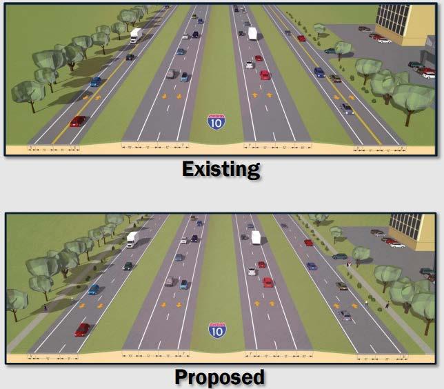
2 Frontage Road Operational Improvements 2


3 Frontage Roads Under Construction Fair Oaks Pkwy to Dominion I-10 - Fair Oaks Pkwy to FM 3351 Scope: Convert frontage roads to one way; construct overpass at Old Fredericksburg Road Cost: $31 Million Contractor: Sundt Construction Anticipated End Date: Late 2018 Fair Oaks Pkwy Scope: Bridge Replacement Expand Bridge to 4 Lanes & WB to EB Turnaround Cost: $7.6 Million Contractor: Relmco Construction Anticipated End Date: Mid 2018 I-10 - FM 3351 to Dominion Dr Scope: Convert Frontage Roads to One-Way; Intersection Boerne Stage Road, Dominion Dr., & Ralph Fair Road; Ramp Improvements Cost: $18.5 Million Contractor: Texas Sterling Construction Anticipated End Date: Completed 3


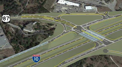
4 Frontage Roads Under Constr. & Planned SH 46 to Fair Oaks Pkwy I-10 SH 46 to Scenic Loop Scope: Convert frontage roads to oneway; replace SH 46 & BS 87 bridges with 6-lane bridges + intersection improvements Cost: $65 Million Contractor: Texas Sterling Construction Anticipated End Date: Mid 2021 SH 46 Scope: Relocate westbound exit ramp and construct partial frontage road Cost: $3.5 Million Contractor: Hanover/Zimmerman Anticipated End Date: Completed Scenic Loop Scope: Replace Overpass & Intersection Improvements Cost: $11.6 Million Contractor: Austin Bridge & Road Anticipated End Date: Mid 2018 Scenic Loop to County Line Scope: Convert frontage roads to oneway; construct new frontage road bridges at Balcones Creek Cost: $20 Million Contractor: TBD Anticipated Let Date: Spring 2019** **Funding Dependent I-10 County Line to Fair Oaks Pkwy Scope: Convert frontage roads to one-way; construct new overpass at Balcones Creek Road & intersection improvements Cost: $29 Million Contractor: TBD Anticipated Letting: July 2018 Anticipated End Date: Mid


5 US 87 (Main Street) Overlay US 87 Main Street (I-10 N to I-10 S) Scope: Resurface with Overlay Cost: $2.0 Million Contractor: Angel Brothers Anticipated End Date: Mid
 SH 46 at Plant Ave 2) RM")
 Main St at")
 Main St at Hickman /")
6 Pedestrian Safety Improvements 1) SH 46 at Plant Ave 2) RM 474 at Old #9 Trail 2) RM 474 at Old #9 Trail 3) Main St at Hickman St 1) SH 46 at Plant Ave 3) Main St at Hickman / Hosack 6
 at Plant Avenue")
7 Site #1 SH 46 (River Road) at Plant Avenue 7

8 Flashing Beacon Options Ground 8

9 Flashing Beacon Options Overhead 9

10 Flashing Beacon Options Rectangular Strobe 10

11 Curb Extension Options 11

12 Accessible Parking Spaces to be Relocated 12
13 Site #1 SH 46 (River Road) at Plant Avenue Design Options Accessibility On-Street Parking $150,000 Bid November 2018 Construction Spring

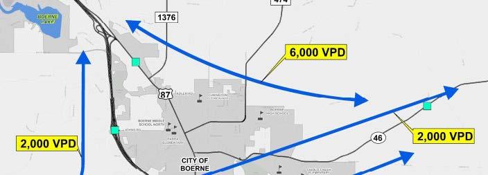
14 Site #2 RM 474 (Blanco Rd) at Old Number 9 Greenway Closely Spaced Driveways and Streets 10,000 vehicles per day 35 mph Existing School Zone w/flashers 4-Lanes Pedestrian Refuge Median 14

15 Site #3 Main Street between Hickman/Hosack Streets Wide Roadway 5 Lanes with Continuous Left-turn Lane Limited Right-of-way Driveways and Streets 35 mph 22,000 vpd Ped Refuge Median 15


16 I-10 North Creek Road to US 87 Comfort - Estimated Construction Cost - $5 Million - Scheduled Letting May Anticipated Construction Duration Months 16


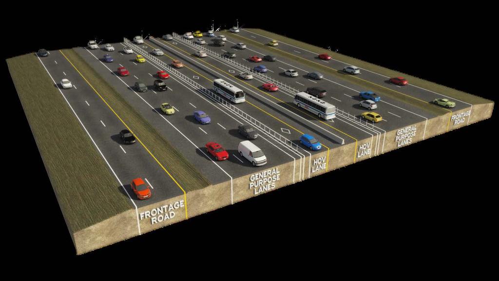
17 I-10 Added Capacity Expansion Near Term I-10 - FM 3351 to La Cantera Pkwy Scope: Expand to 6 Lane Expressway + HOV Lane Cost: $ 70 Million Contractor: Flatiron Scheduled Letting: May 2017 Anticipated End Date: Late


18 Added Capacity Expansion 18


19 I-10 Added Capacity Expansion - Planned I-10 SH 46 to FM 3351 Scope: Expand Expressway Cost: $ 190 Million Contractor: TBD Scheduled Letting: TBD* Anticipated End Date: TBD* *Timeframes Dictated by Available Funding 19


20 SH 46 Expansion Esser to Ammann 20
21 SH 46 Expansion Scheduled Letting June 2018 Estimated Construction Cost - $11 Million Anticipated Construction Duration 18 Months Project Development Status: Environmental Cleared PS&E (Construction Plans) 95% complete Right of Way Acquisition Completed Utility Conflicts Some overhead conflicts remain **City of Boerne power poles are on critical path** 21
22
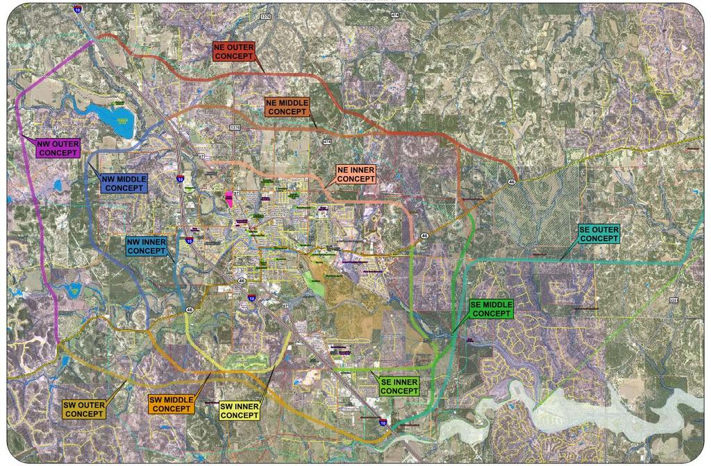
 METHOD OF CORRIDOR ROW PRESERVATION TO BE")
23 JOINT RESOLUTION WITH CITY AND COUNTY THIS IS A DATA DRIVEN PLANNING PROJECT TECHNICAL ANALYSIS PUBLIC INVOLVEMENT/FEEDBACK GOAL OF STUDY IDENTIFY VIABLE CORRIDORS WITH INTENT TO PRESERVE RIGHT OF WAY (ROW) METHOD OF CORRIDOR ROW PRESERVATION TO BE DETERMINED

24 DOWNTOWN BOERNE Preserve Boerne as a Destination Provide Efficient Through Route Provide System Redundancy IMAGES FROM GOOGLE
25

26
27
28 ALTERNATIVE SCREENING PROCESS Identify Universe of Alternatives Level 1 Screening (Fatal Flaw Analysis) Reasonable Alternatives WE ARE HERE Level 2 Screening Recommended Alternative(s)
29 Next Steps Refine Reasonable Concepts based on TWG/SWG workshop Reduce Reasonable Concepts to Recommended Concepts Present Recommended Concepts at 3 rd Public Meeting (Spring 2018) Draft Feasibility Report (Spring 2018)
I-10 AT SCENIC LOOP RD. Open House
 I-10 AT SCENIC LOOP RD Open House General Information I-10 At Scenic Loop Rd KENDALL COUNTY OPEN HOUSE June 30, 2015 Currey Creek Baptist Church 35 Cascade Cavern 5:00 7:00 Boerne, TX 78015 2 Public Meeting
"Mobility 2045" Alphabetical Listing of Roadway, Bicycle, Pedestrian and Rideshare Projects
 Number Alamo Area Commute Alamo Area MPO: Bexar, Comal Guadalupe & partial Kendall County AACOG Solutions Program Alamo Area Commute Solutions Pgm - FY 2017 $100,000 5101.0 0915-12-547 7/2018 Bexar Alamo
FY Transportation Improvement Program - DRAFT Alphabetical Listing of Roadway, Bicycle, Pedestrian and Rideshare Projects
 -2022 Transportation Improvement Program - DRAFT Project Number Alamo Area Commute Solutions Pgm - FY 2017 5101.0 0915-12-547 AACOG Alamo Area Commute Solutions Pgm - FY 2018 5102.0 0915-12-543 AACOG Alamo
Welcome. Thank you for attending tonight s open house. The purpose of this open house is to give you an opportunity to:
 Welcome Thank you for attending tonight s open house. The purpose of this open house is to give you an opportunity to: Review the circulation plan concept Give us your input Why a circulation plan? During
Blair/Williamson Intersection Expressed Needs
 Blair/Williamson Intersection Expressed Needs NORTH Blair Street is a barrier for pedestrians and bicycles Relocate Capitol City Trail crossing from Blair Street and John Nolen Drive intersection to Williamson
County Board Workshop
 CH 21 Downtown Reconstruction Project County Board Workshop Tuesday, October 24, 2017 CH 21 Downtown Prior Lake Reconstruction Agenda 1) Review remaining Project Alternatives 2) Public Engagement Summary
AAMPO MOBILITY PROJECT DISCUSSION. July/August 2015
 AAMPO MOBILITY PROJECT DISCUSSION July/August 2015 Proposition 1 FY 16 & 17 $1.74 billion transferred to State Highway Fund in FY 2015 $147.3 million let in SAT district in FY 2015 US 90, IH 10, IH 410
I-35 COMAL COUNTY OPERATIONAL IMPROVEMENTS
 I- COMAL COUNTY OPERATIONAL IMPROVEMENTS OPEN HOUSE The environmental review, consultation, and other actions required by applicable Federal environmental laws for this project are being, or have been,
Project Update May 2018
 Project Update May 2018 Dakota County, in cooperation with the City of Lakeville, is planning to reconstruct 202 nd Street West (County Road 50) from Holyoke Avenue to Cedar Avenue (County Road 23). 202
Feasibility Study of Pedestrian Crossings Along Route 7, East of Cascades Parkway and West of Dranesville Road. October 3, 2017
 Feasibility Study of Pedestrian Crossings Along Route 7, East of Cascades Parkway and West of Dranesville Road October 3, 2017 Study Area (area within a ¼-mile radius of the study intersections) Route
US 278 Corridor Concept Presentation. Avondale Estates Intersection Improvement/Roundabout and Road Diet Feasibility Study March 19, 2015
 US 278 Corridor Concept Presentation Avondale Estates Intersection Improvement/Roundabout and Road Diet Feasibility Study March 19, 2015 Thanks to our Partners Atlanta Regional Commission Georgia Department
Bay to Bay Boulevard Complete Streets Project
 Bay to Bay Boulevard Complete Streets Project Dale Mabry Highway to Bayshore Boulevard February 08, 2018 Photo Source: Tampa Bay Times Alessandra Da Pra Meeting Format Introduction Resurfacing Information
Southwest Bus Rapid Transit (SW BRT) Functional Planning Study - Executive Summary January 19 LPT ATTACHMENT 2.
 Functional Planning Study - Executive Summary January 19 LPT ATTACHMENT 2.") Southwest Bus Rapid Transit (SW BRT) Functional Planning Study - Executive Summary 2011 January 19 1 of 19 Introduction This executive summary presents the results of the Southwest Bus Rapid Transit (SW
Southwest Bus Rapid Transit (SW BRT) Functional Planning Study - Executive Summary 2011 January 19 1 of 19 Introduction This executive summary presents the results of the Southwest Bus Rapid Transit (SW
US 20 Feasibility Study. Village Board Meeting. Shales Parkway to IL Route 390 IL Route 390 Extension (North Ave to US 20)
") US 20 Feasibility Study Shales Parkway to IL Route 390 IL Route 390 Extension (North Ave to US 20) Village Board Meeting Bartlett Village Hall February 16, 2016 1 Background 1991 IDOT Study Recommendations
US 20 Feasibility Study Shales Parkway to IL Route 390 IL Route 390 Extension (North Ave to US 20) Village Board Meeting Bartlett Village Hall February 16, 2016 1 Background 1991 IDOT Study Recommendations
Corridor Advisory Group and Task Force Meeting #10. July 27, 2011
 Corridor Advisory Group and Task Force Meeting #10 July 27, 2011 1 Agenda Recap CAG/TF #9 Public Meeting #2 Summary Single Mode Alternatives Evaluation Results Next Steps 2 3 CAG/TF #9 Recap CAG /TF #9
NEW BRAUNFELS SEGUIN AREA REGIONAL TRANSPORTATION DRAFT PLAN NEW BRAUNFELS CITY COUNCIL MEETING
 NEW BRAUNFELS SEGUIN AREA REGIONAL TRANSPORTATION DRAFT PLAN NEW BRAUNFELS CITY COUNCIL MEETING February 13, 2012 This regional transportation plan will: 1. Review existing plans for the cities and counties,
Washington St. Corridor Study
 FIGURE 7.17 Bridge Alternatives - Cross Sections 86 Discarded Alternative: Short-Term Bridge Repair Short-term repairs and west bridge span replacement were considered during analysis. Short-term repairs
Proposed Action, Purpose and Need Technical Memorandum
 Proposed Action, Purpose and Need Technical Memorandum MoPac (State Loop 1) Intersections, Austin District From North of Slaughter Lane to South of La Crosse Avenue CSJ: 3136-01-015 Travis County, Texas
FM 471 PROJECT. OPEN HOUSE FM 471 (Culebra Road) from SH 211 to Old FM 471 Medina and Bexar Counties. FM 471 Project
 from SH 211 to Old FM 471 Medina and Bexar Counties. FM 471 Project") FM 471 PROJECT OPEN HOUSE FM 471 (Culebra Road) from SH 211 to Old FM 471 Medina and Bexar Counties January 24, 2018 Project Location 2 Proposed Improvements Improvements include: Expansion of FM 471 from
FM 471 PROJECT OPEN HOUSE FM 471 (Culebra Road) from SH 211 to Old FM 471 Medina and Bexar Counties January 24, 2018 Project Location 2 Proposed Improvements Improvements include: Expansion of FM 471 from
Atwood Avenue Fair Oaks Avenue Cottage Grove Road
 Atwood Avenue Fair Oaks Avenue Cottage Grove Road Agenda Purpose Review project scope & goals Present design alternatives Gather feedback Answer Questions Format Open House Presentation Q&A Open House
Short and Long Term Needs
 Short and Long Term Needs The short- and long-term programs of proposed projects listed below have been designed to address the mobility issues in South Montgomery County. These improvements to the transportation
City of Gainesville Transportation/Roadway Needs PROJECT SUMMARY
 A1 Roadway Resurfacing $23,846,000 TYPE: Preservation of existing system Roadway resurfacing A2 Signal Replacement $6,000,000 TYPE: Preservation of existing system Replace traffic signals. B1 W 6th St
DULLES AREA TRANSPORTATION ASSOCIATION (DATA) February 18, Susan Shaw, P.E., VDOT, Megaprojects Director
 February 18, Susan Shaw, P.E., VDOT, Megaprojects Director") DULLES AREA TRANSPORTATION ASSOCIATION (DATA) February 18, 2015 Susan Shaw, P.E., VDOT, Megaprojects Director I-66 Corridor Conditions Steady population growth Employment growth in activity centers Congestion
DULLES AREA TRANSPORTATION ASSOCIATION (DATA) February 18, 2015 Susan Shaw, P.E., VDOT, Megaprojects Director I-66 Corridor Conditions Steady population growth Employment growth in activity centers Congestion
Lincoln Highway Streetscape Plan Concept Plan
 Lincoln Highway Streetscape Plan Concept Plan November 14, 2014 Introduction This report provides a summary of conceptual transportation, land use, and design recommendations in the Lincoln Highway Streetscape
2012 PRIORITY TRANSPORTATION PROJECTS
 0 PRIORITY TRANSPORTATION PROJECTS The 0 Priority Transportation Projects include candidate road, congestion management, multi-use trail, transit, transportation regional incentive program (TRIP), county
Poor pavement condition Substandard Intersections. / Substandard bike/pedestrian/transit accommodations. Driveway access Environmental concerns
 Public Informational Meeting University Avenue (Allen Boulevard Segoe Road) March 23, 2011 City of Madison City of Middleton Village of Shorewood Hills Dane County Existing Roadway Conditions Poor pavement
INGHAM COUNTY ROAD DEPARTMENT AUSTIN E. CAVANAUGH ADMINISTRATION BUILDING 301 Bush Street, P.O. Box 38, Mason, MI
 INGHAM COUNTY ROAD DEPARTMENT AUSTIN E. CAVANAUGH ADMINISTRATION BUILDING 301 Bush Street, P.O. Box 38, Mason, MI 48854-0038 March 27, 2018 William M. Conklin, P.E. Managing Director FOR IMMEDIATE RELEASE:
Section Access Control Plan - SH 14 (Mulberry Street)
") US 287/SH 14 Access Management Report Section 5.0 - Access Control Plan - SH 14 (Mulberry Street) Page 92 US 287/SH 14 Access Management Report Section 5.0 - Access Control Plan - SH 14 (Mulberry Street)
US 287/SH 14 Access Management Report Section 5.0 - Access Control Plan - SH 14 (Mulberry Street) Page 92 US 287/SH 14 Access Management Report Section 5.0 - Access Control Plan - SH 14 (Mulberry Street)
Ottawa Beach Road Study
 Ottawa Beach Road Study Prepared For: Park Township September 30, 2014 Project No. G140303 OTTAWA BEACH ROAD STUDY PREPARED FOR: PARK TOWNSHIP SEPTEMBER 30, 2014 PROJECT NO. G140303 TABLE OF CONTENTS 1.0
Superstreet Concepts & Application. Prepared by: PAPE-DAWSON ENGINEERS, INC. October 16, 2012
 Superstreet Concepts & Application Prepared by: PAPE-DAWSON ENGINEERS, INC. October 16, 2012 1 Purpose of a Superstreet Improve Traffic Flow Increased Safety Economical Solution What is a Superstreet?
GRTC Bus Rapid Transit: Semi-Final Design Phase Public Meetings: October 26 & 27, 2015
 GRTC Bus Rapid Transit: Semi-Final Design Phase Public Meetings: October 26 & 27, 2015 Welcome! Meeting Agenda Project update presentation Up to 15 minutes for Pulse Q&A about project design. (Please reserve
I-20 ODESSA-MIDLAND CORRIDOR STUDY. Public Meeting for Schematic Design
 I-20 ODESSA-MIDLAND CORRIDOR STUDY Public Meeting for Schematic Design The environmental review, consultation, and other actions required by applicable Federal environmental laws for this project are being,
ACTION TRANSMITTAL No
 Transportation Advisory Board of the Metropolitan Council of the Twin Cities DATE: August 25, 2016 TO: FROM: ACTION TRANSMITTAL No. 2016-47 Technical Advisory Committee TAC Funding and Programming Committee
Pine Hills Road Pedestrian/Bicycle Safety Study Board of County Commissioners Work Session
 Pine Hills Road Pedestrian/Bicycle Safety Study Board of County Commissioners Work Session February 20, 2018 Meeting Agenda Study Overview Existing Conditions Access Management Potential Gateway Features
2014/2015 BIKE ROUTE PLAN 83 AVENUE PROTECTED BIKE LANE
 About the Project The City of Edmonton is planning a major bike route on the southside of Edmonton. The Strathcona Bike Route will connect the communities of Strathcona, Garneau and the University area,
TRANSPORTATION COMMISSION Agenda Staff Report
 TRANSPORTATION COMMISSION Agenda Staff Report Agenda Item No. 5.a DATE: JULY 31, 2014 TO: FROM: SUBJECT: TRANSPORTATION COMMISSION COMMUNITY DEVELOPMENT DEPARTMENT - PLANNING DRAFT OLYMPIC CORRIDOR PREFERRED
FY STIP. Austin District. November Quarterly Revisions HIGHWAY STATEWIDE TRANSPORTATION IMPROVEMENT PROGRAM
 FY 2011-2014 STIP STATEWIDE TRANSPORTATION IMPROVEMENT PROGRAM HIGHWAY Austin District November Quarterly Revisions November 2011 FY 2011-2014 Transportation Improvement Program Amendments October 10,
Southbend to Prima Vista. October 30, Floresta Corridor Master Plan
 Application of a Complete Street initiative and how it might function operationally 8 8 Southbend to Prima Vista October 30, 2017 Presentation Agenda 2 Perspective and History Traffic projections, Levels
Dr. M.L. King, Jr. Street North Complete Streets Resurfacing Opportunities HOUSING, LAND USE, AND TRANSPORTATION COMMITTEE MARCH 22, 2018
 Dr. M.L. King, Jr. Street North Complete Streets Resurfacing Opportunities HOUSING, LAND USE, AND TRANSPORTATION COMMITTEE MARCH 22, 2018 What s Happening The City plans to mill and resurface Dr. M.L.
CHAPTER 1 INTRODUCTION
 CHAPTER 1 INTRODUCTION Chapter Table of Contents THE 2017 HOUSTON BIKE PLAN 1-1 HOUSTON BIKEWAYS PROGRAM 1-2 HISTORY OF BICYCLE PLANNING IN HOUSTON 1-3 BICYCLE LEVEL OF COMFORT 1-3 EXISTING PLANS, PROGRAMS
Purpose + Need. Connect: Thrive: Develop: < Strengthen the spine of our regional transportation system
 Purpose + Need I-29 NW Barry Road 64/68/72 MAIN STREET Connect: < Strengthen the spine of our regional transportation system Leavenworth Road Parallel Parkway State Avenue 18th Street Expressway Shawnee
Operations -- Transit From: N/A To: N/A. Improvement Type: Regionally Significant: No
 Central Puget Sound Regional 2017-2020 Transportation Improvement Program Amendments and Corrections to be included in the 2017-20 STIP PSRC's Amendment 2017-08 County: King List of 17-08 Amendment Projects:
Access Management Regulations and Standards
 Access Management Regulations and Standards January 2014 Efficient highway operation Reasonable property access Concept of Access Management The way to manage access to land development while preserving
Paul Huston, P.E., Design-Build Coordinator Chuck Gonderinger, HDR Engineering. Minnesota Department of Transportation (the Department)
") To: From: Paul Huston, P.E., Design-Build Coordinator Chuck Gonderinger, HDR Engineering Date: March 20, 2001 Subject: Roadway Geometric Design Criteria Project: TH 14/218 Design-Build Project, SP 7408-29,
To: From: Paul Huston, P.E., Design-Build Coordinator Chuck Gonderinger, HDR Engineering Date: March 20, 2001 Subject: Roadway Geometric Design Criteria Project: TH 14/218 Design-Build Project, SP 7408-29,
Tonight is for you. Learn everything you can. Share all your ideas.
 Strathcona Neighbourhood Renewal Draft Concept Design Tonight is for you. Learn everything you can. Share all your ideas. What is Neighbourhood Renewal? Creating a design with you for your neighbourhood.
Freeway System Considerations
 Session 11 Jack Broz, PE, HR Green May 5-7, 2010 Freeway System Considerations Mainline Transit: Shoulder Operations, BRT, Stations HOV, HOT, UPA Interchanges Exit Ramps Entrance Ramps Bridges Local Crossings
City of Sammamish. Welcome. Issaquah-Fall City Road Improvements Project Phase I Design: 242nd Avenue SE to Klahanie Drive SE
 Welcome Welcome to the third community meeting for the Issaquah-Fall City Road Improvements Project. AGENDA 6:00 p.m. Welcome and sign-in 6:10 p.m. Presentation 6:50 p.m. Open house Learn about the roadway
MnPASS System Today and the Future
 MnPASS System Today and the Future April 2010 By Nick Thompson Minnesota Department of Transportation Topics Minnesota s Current and Future MnPASS High Occupancy Toll Systems Overview of the MnPASS System
Commerce Street Complete Street Project from Good Latimer Expressway to Exposition Avenue
 Commerce Street Complete Street Project from Good Latimer Expressway to Exposition Avenue T A N Y A B R O O K S A S S I S T A N T D I R E C T O R M O B I L I T Y P L A N N I N G M O B I L I T Y A N D S
Figure 1: Vicinity Map of the Study Area
 ARIZONA TEXAS NEW MEXICO OKLAHOMA May 5, 2016 Mr. Anthony Beach, P.E. BSP Engineers 4800 Lakewood Drive, Suite 4 Waco, Texas 76710 Re: Intersection and Access Analysis along Business 190 in Copperas Cove
About the study. North Milwaukee Ave. Key goals of this study are to: Achieve Vision Zero* by. Harmonize the space and improve walkability
 About the study Key goals of this study are to: North Milwaukee Avenue is a local and regional street for multiple modes of transportation. It is officially zoned and functions as a pedestrian street southeast
2014/2015 BIKE ROUTE PLAN 83 AVENUE PROTECTED BIKE LANE
 About the Project 2014/2015 BIKE ROUTE PLAN The City of Edmonton is planning a major bike route on the south side of Edmonton. This bike route is one part of a plan to provide citizens with transportation
WELCOME. to the meeting for the. Westside Avenue Action Plan Gateway to Revitalization
 WELCOME to the meeting for the Columbia Road - Before and After Ridge Road - Before and After Before and After WAAP Bridge Sections Fountain Creek Before Retaining Wall for Roadway 30' Existing Fountain
Route 29 Solutions Projects
 Route 29 Solutions Route 29 Solutions Projects www.route29solutions.org October 10, 2014 Route 29 Widening to Six Lanes Albemarle County This project will widen a 1.8-mile segment of Route 29 from four
SH-6 Corridor Improvement Study Policy Committee Progress Report M O N D AY, J U N E 1 0, B R A Z O S C E N T E R
 SH-6 Corridor Improvement Study Policy Committee Progress Report M O N D AY, J U N E 1 0, 2 0 1 3 B R A Z O S C E N T E R Project Overview Study Goals and Objectives» Improve traffic flow» Reduce delay»
Congress Avenue. Palm Beach MPO Subcommittee Meetings December 2017
 1 Congress Avenue Palm Beach MPO Subcommittee Meetings December 2017 2 Agenda Study Purpose Study Process Multimodal Alternatives Development Next Steps *ACTION ITEM: CONFIRM ALTERNATIVES TO MOVE INTO
PEDESTRIAN ACCOMMODATIONS DPS 201 AT INTERCHANGES
 PEDESTRIAN ACCOMMODATIONS DPS 201 AT INTERCHANGES UNDERSTANDING THE ISSUES Intersections of freeway ramp terminals at crossroads are the most critical components of an interchange Challenge: balance mobility
COMMUNITY MEETING AGENDA
 COMMUNITY MEETING AGENDA Welcome and Introductions SAFE Presentation Project Presentation Priorities Feedback Next Steps Q&A Santa Cruz Avenue Corridor Study 1 Santa Cruz Avenue Corridor Study Community
SC 41/Joe Rouse Intersection Improvements
 SC 41/Joe Rouse Intersection Improvements Scope: Add dual left-turn lanes from Joe Rouse Road onto southbound SC 41 to reduce re-occurring peak hour congestion, particularly the AM peak. Construction Cost
Mark Malone, P.E. SD DOT
 Mark Malone, P.E. SD DOT SD10 Grading & Surfacing From 8 th Ave W to 8 th Ave E 1 mile plus transition lengths Complete Urban Reconstruction Grading, C&G, Storm Sewer, Sidewalk, Concrete Surfacing Railroad
"Mobility 2040" Alphabetical Listing of Roadway, Bicycle, Pedestrian and Rideshare Projects
 Number Alamo Area Commute Alamo Area MPO: Bexar, Comal Guadalupe & partial Kendall County AACOG Solutions Program Alamo Area Commute Solutions Pgm - FY 2017 $100,000 5101.0 0915-12-547 7/2018 Alamo Area
SUPERSTREETS IN TEXAS. ITS Texas Annual Meeting San Marcos, Texas Session 6A - Operations November 11, 2011
 SUPERSTREETS IN TEXAS ITS Texas Annual Meeting San Marcos, Texas Session 6A - Operations November 11, 2011 1 Superstreet Corridor Location 2 3 US Highway 281 2007 Looking south above Evans Road, pm peak
Overview. Illinois Bike Summit IDOT Complete Streets Policy Presentation. What is a Complete Street? And why build them? And why build them?
 Overview Illinois Bike Summit IDOT Complete Streets Policy Presentation Aren Kriks, P.E. District One Bicycle Coordinator and Bureau of Programming Project Engineer History of Complete Streets IDOT Policy
Legislative Update Williamsburg Residency
 Hampton Roads District Legislative Update Williamsburg Residency Jim Brewer, Resident Administrator 757-253-5140 Projects Under Way Warwick Boulevard Project http://www.warwickboulevard.org/ Contractors:
Brooklyn Boulevard (County Road 152) Reconstruction Project Phase I. OPEN HOUSE June 20, 2017
 Reconstruction Project Phase I. OPEN HOUSE June 20, 2017") Brooklyn Boulevard (County Road 152) Reconstruction Project Phase I OPEN HOUSE June 20, 2017 Brooklyn Boulevard (County Road 152) Phase I Project Partners Project Lead Other Project Partners include Brooklyn
Brooklyn Boulevard (County Road 152) Reconstruction Project Phase I OPEN HOUSE June 20, 2017 Brooklyn Boulevard (County Road 152) Phase I Project Partners Project Lead Other Project Partners include Brooklyn
Water Street Promenade. Engineering and Design Services. Public Information Meeting No. 2. Education / Infrastructure / Innovation. Maplewood Avenue &
 Public Information Meeting No. 2 Water Street Promenade Maplewood Avenue & Engineering and Design Services Adjacent Areas July 16,2014Portsmouth, NH May 10, 2016 Education / Infrastructure / Innovation
Hillsboro Tanasbourne Town Center
 Hillsboro Tanasbourne Town Center Tanasbourne Town Center Hillsboro The Tanasbourne Town Center focus area is located in the City of Hillsboro. It is situated approximately six miles from the City of Hillsboro
Presentation Outline. Project/Study Purpose. Existing Conditions. Future Conditions. Understanding the Streetside. Similar Walkable Environments
 Presentation Outline Project/Study Purpose Study Area Map Existing Conditions Future Conditions Understanding the Streetside Similar Walkable Environments Conceptual Alternatives Magnolia/NE 1st Ave Block
FM 1092/Murphy Road Access Management Study Pulic Meeting #1. Wednesday, August 31, :00 p.m. 8:00 p.m.
 FM 1092/Murphy Road Access Management Study Pulic Meeting #1 Wednesday, August 31, 2011 6:00 p.m. 8:00 p.m. Introductions Agency Partners H-GAC Missouri City TxDOT Introductions Consulting Team In Association
EL CAMINO REAL BUS RAPID TRANSIT PROJECT
 EL CAMINO REAL BUS RAPID TRANSIT PROJECT Would upgrade the current 522 Rapid Bus to BRT status by making changes to El Camino Real and The Alameda that make transit FAST, FREQUENT AND RELIABLE and make
This page intentionally left blank.
 This page intentionally left blank. COMMUNITY Coweta Community Overview Coweta Coweta, a residential community located in Wagoner County, is a suburb of Tulsa situated southeast of the metropolitan area
Highway 49, Highway 351 and Highway 91 Improvements Feasibility Study Craighead County
 Highway 49, Highway 351 and Highway 91 Improvements Feasibility Study Craighead County Executive Summary March 2015 Highway 49, Highway 351 and Highway 91 Improvements Feasibility Study Craighead County
Bluffdale/ UDOT South High-T Intersection Project Type Operations
 Bluffdale/ UDOT 14600 South High-T Intersection Project Type Operations 14600 South and Redwood Road $ 600,000 $ 550,000 This project is to install a new High-T intersection at Redwood Road and 14600 South
PROJECT PURPOSE & NEED
 PROJECT PURPOSE & NEED Expansion to a four-lane divided highway will address congestion on a critical roadway that provides connections to established industrial parks, significant commercial businesses
Appendix A. Knoxville TPO Greenway Signage Guidelines. Appendix A: Knoxville TPO Greenway Signage Guidelines Knox to Oak Ridge Greenway Master Plan
 Appendix A Knoxville TPO Greenway Signage Guidelines 75 Overview: Adequate signing and marking are essential on shared-use paths, especially to alert bicyclists to potential conflicts and to convey regulatory
Hidden Oaks Elementary School
 Hidden Oaks Elementary School SCHOOL ROUTE PLAN For HIDDEN OAKS ELEMENTARY SCHOOL LOCATION 13 ORANGE COUNTY Prepared for: ORANGE COUNTY SCHOOL ASSESSMENT PROGRAM ORANGE COUNTY PUBLIC WORKS Traffic Engineering
COWETA HIGH SCHOOL AND EAST HIGHWAY 51
 COWETA HIGH SCHOOL AND EAST HIGHWAY 51 Lack of sidewalks along Ben Lumpkin Rd. Lack of crosswalks and ramps at intersection. Hwy 51 is wide to cross as a pedestrian. No ADA compliance or connection to
PROJECT OBJECTIVES. Improve vehicle capacity for the intersection. Improve pedestrian and bicycle access
 COMMUNITY MEETING Project Update March 15, 2010 Purcellville, Virginia OVERVIEW Project need / objectives Project recap Design elements Proposed improvements Summary of project benefits / next steps PROJECT
WELCOME! OPEN HOUSE SHAW ROAD IMPROVEMENT PROJECT JUNE 30, 2015
 WELCOME! OPEN HOUSE SHAW ROAD IMPROVEMENT PROJECT JUNE 30, 2015 Traffic Improvements Project Goals Widen roadway to construction two-way left turn lanes-greatly decreases congestion Ease access to & from
Part of Growing Rail Network
 May 3, 2017 Part of Growing Rail Network Montclair Construction Authority s Responsibility Metro s 2009 Long Range Transportation Plan, projects partially funded by Measure R Gold Line s 3 Phases = $3
Chapter 4 Traffic Analysis
 Chapter 4 Traffic Analysis PURPOSE The traffic analysis component of the K-68 Corridor Management Plan incorporates information on the existing transportation network, such as traffic volumes and intersection
Acknowledgements. Mr. David Nicol 3/23/2012. Daniel Camacho, P.E. Highway Engineer Federal Highway Administration Puerto Rico Division
 Daniel Camacho, P.E. Highway Engineer Federal Highway Administration Puerto Rico Division Acknowledgements Mr. David Nicol Director, FHWA Office of Safety FHWA Office of Safety http://safety.fhwa.dot.gov/provencountermeasures/
Board of Supervisors February 27, 2017
 : Traffic Analysis Results & Draft Conceptual Plan Board of Supervisors February 27, 2017 Transportation Solutions Building Better Communities Presentation Overview Background Summary of Traffic Analysis
RM 620/RM 2222 CONNECTOR (BYPASS) STATUS REPORT RM 620/2222 STATUS
 STATUS REPORT RM 620/2222 STATUS") RM 620/RM 2222 CONNECTOR (BYPASS) STATUS REPORT January 25, 2017 RM 620/2222 BYPASS - INTRODUCTION Because of the enormous traffic demand at the RM 620/2222 intersection, TxDOT searched for a way to relieve
RM 620/RM 2222 CONNECTOR (BYPASS) STATUS REPORT January 25, 2017 RM 620/2222 BYPASS - INTRODUCTION Because of the enormous traffic demand at the RM 620/2222 intersection, TxDOT searched for a way to relieve
Transportation Planning Division
 Transportation Planning Division Presentation Outline Study Tasks Recap of Previous Meetings Data Collected Focus Areas within Study Limits Design Principles Tool Box Recommended Concepts Schedule Moving
University Avenue & Farley Avenue/University Bay Drive Area Scenario Base Conditions Multiple concerns
 ped at signalized East of U-Bay North of Campus on Farley Ave./ U-Bay & Westbound Campus North of on Farley Ave./ U-Bay Near VA on MB1: Dual Eastbound Left-Turn Lanes Generally compatible with BRT and
IH 20 RANGER HILL PUBLIC MEETING
 IH 20 RANGER HILL PUBLIC MEETING AUGUST 25, 2015 IH 20, Eastland County, TX CSJ 0007-06-084 IH 20 from 3.5 mi. East of LP 254 to SH 16 (Ranger Hill) August 25, 2015 Agenda Introductions Purpose of the
Project Team. Refined Pedestrian Crossing Toolbox. Problem Statement. Aerial of Study Corridor. Crossing Accommodations and Pedestrian Fatalities
 Project Team Refined Pedestrian Crossing Toolbox Treatments on Wide, High Speed Urban Roadways Developed as Part of the Springfield Main Street (OR 126) Safety Study Consultants Scott Mansur, P.E., P.T.O.E.
FOCUS AREA 1 - Alberta Avenue Pocket Park 3 (121 Ave and 92 St)
") FOCUS AREA 1 - Alberta Avenue Pocket Park 3 (121 Ave and 92 St) New benches Plant evergreen trees Widen existing sidewalk from 1.5m to 1.8m Marked crosswalk 1.8m wide sidewalk Add pedestrian oriented lights
FOCUS AREA 1 - Alberta Avenue Pocket Park 3 (121 Ave and 92 St) New benches Plant evergreen trees Widen existing sidewalk from 1.5m to 1.8m Marked crosswalk 1.8m wide sidewalk Add pedestrian oriented lights
Omaha s Complete Streets Policy
 Omaha s Complete Streets Policy (Adopted August 2015) VISION To create great places and enhance our quality of life, the City of Omaha will provide safe, accessible streets for all users. Complete Streets
Make Lincoln Highway an economically vibrant corridor that is safe, efficient, and beautiful for local residents and visitors.
 Lincoln Highway Streetscape Plan Stakeholder Workshop #2 Handout Contents Introduction and Project Vision Planning Principles Specific Recommendations including a Proposed Typical Roadway Section Renderings
Road Diets. Presented by: Cristine Gowland, P.E. LADOTD District 62 March 2, 2016
 Road Diets Presented by: Cristine Gowland, P.E. LADOTD District 62 March 2, 2016 FHWA s 9 Proven Safety Countermeasures 1. Safety Edge 2. Roundabouts 3. Corridor Access Management 4. Backplates with Retroreflective
Road Diets FDOT Process
 Florida Department of TRANSPORTATION Road Diets FDOT Process Humberto Castillero, PE, PTOE Roadway Design Office Purpose of Guide Develop a statewide lane elimination review process Balance state & local
INNOVATIVE INTERSECTION DESIGN
 INNOVATIVE INTERSECTION DESIGN J. Eddie Valtier, P.E. ELP TP&D Director Introduction Why Do We Need To Start Looking For Innovative Intersection Designs? Congestion is worsening and traffic volumes and
NOTICE OF PREPARATION. Environmental Programs 3331 North First Street, Building B-2 San Jose, CA
 NOTICE OF PREPARATION May 29, 2018 To: Reviewing Agencies and Organizations From: Santa Clara Valley Transportation Authority Environmental Programs 3331 North First Street, Building B-2 San Jose, CA 95134-1927
BALBOA AREA: TRANSPORTATION PROJECTS & PLANNING
 BALBOA AREA: TRANSPORTATION PROJECTS & PLANNING TRANSPORTATION FOR ALL AGES, ABILITIES & MEANS CHANGING PATTERNS: TRENDING TO WALKING, BIKING, TRANSIT San Francisco s Change in Number of Commuters by Mode
Municipal Class EA To Address Traffic Congestion On The Ontario Street Corridor (Grand Bend) Public Information Meeting June 4, 2018
 Public Information Meeting June 4, 2018") Municipal Class EA To Address Traffic Congestion On The Ontario Street Corridor (Grand Bend) Public Information Meeting June 4, 2018 Background Agenda Traffic Study Update Class EA Alternatives Bridge
Municipal Class EA To Address Traffic Congestion On The Ontario Street Corridor (Grand Bend) Public Information Meeting June 4, 2018 Background Agenda Traffic Study Update Class EA Alternatives Bridge
Clay Street Bridge Replacement Project
 Clay Street Bridge Replacement Project Frequently Asked Questions (FAQs) The project is located in downtown Placerville on Clay Street between US Highway 50 and Main Street and Cedar Ravine Road. The proposed
Los Altos Hills Town Council - June 18, 2015 Palo Alto City Council June 22, AGENDA ITEM #2.B Presentation
 Los Altos Hills Town Council - June 18, 2015 Palo Alto City Council June 22, 2015 AGENDA ITEM #2.B Presentation Previous Presentations Los Altos Hills Town Council in May 2014 and February 2015 Palo Alto
City of Davis East Covell Corridor Plan
 Community Open House #2 January 22, 2014 6:00 8:00 p.m. Veterans Memorial Center, Club Room City of Davis Introduction The (ECCP) is a taking a comprehensive look at the existing transportation systems