TOWNSHIP OF BRICK BICYCLE AND PEDESTRIAN MASTER PLAN. Public Open House Meeting Tuesday, April 17, :30-8:00 PM
|
|
|
- Linda Little
- 5 years ago
- Views:
Transcription


1 TOWNSHIP OF BRICK BICYCLE AND PEDESTRIAN MASTER PLAN Public Open House Meeting Tuesday, April 17, :30-8:00 PM
2 INTRODUCTORY REMARKS About LPS: Assist communities with land use and planning goals No cost technical assistance Services & Qualification Criteria LPS Project Team: Ramond Joseph, AICP Maria Connolly, AICP/PP Geoffrey Gray-Cornelius
3 5:45 PM Presentation AGENDA ITEMS Bicycle & Pedestrian Plan Progress Update Policy/ Programming Recommendations Pedestrian Network Recommendations Bicycle Network Recommendations Bicycle & Pedestrian Network Prioritization Next Steps/Question and Answer 6:30 PM Planning Workshop Stations Policy/ Programming Recommendations Pedestrian Facility Network Recommendations Bicycle Facility Network Recommendations Bicycle & Pedestrian Network Prioritization 7:30-8:00 PM Clean-up/ Meeting Adjourns
4 1. BICYCLE & PEDESTRIAN PLAN PROGRESS UPDATE Brick Bike Walk
5 COMMUNITY VISION AND GOALS Walking and bicycling is safe, enjoyable and convenient for all people of all ages and abilities Goal 1: Improve Safety Goal 2: Enhance accessibility, mobility and connectivity Goal 3: Become a Complete Streets community Bicycle and pedestrian facilities link places where people live, work and recreate Goal 4: Incorporate and integrate bicycle/pedestrian facilities Goal 5: Achieve healthy sustainable communities Goal 6: Foster Culture Shift

6 Schools Brick Plaza Windward Park Brick Barrier Island/Beaches Chambers Bridge Road between Route 70 and Lakewood Township Shop Rite/Kohl s Plaza Trader s Cove Brick Township Reservoir

7 SAFETY HOT SPOTS 92% of ped-vehicle and 96% of bikevehicle crashes on county/state roads 32% of bike-vehicle and 51% of pedvehicle crashes within Commercial Corridor / downtown Brick 54% of all bike and 47% of all pedestrian crashes within 500 feet of signalized intersection 77% of pedestrian crashes at intersections occurred where crosswalks were fully or partially missing 39% of pedestrian hits occurred in locations with no sidewalk

8 COMMUNITY CONNECTIVITY & SAFETY RECOMMENDATIONS
9 LEVEL OF TRAFFIC STRESS RESULTS Almost all county and state roads are LTS IV mph 35 Almost all local roads are LTS I mph = 25 Note: LTS may actually be higher: presence of obstacles (i.e. parked school buses), high traffic volume, etc. increases stress
10 2. PROGRAMMING/POLICY RECOMMENDATIONS Brick Bike Walk
11 PROGRAMMING & POLICY RECOMMENDATIONS Education NJ Safe Routes to School Street Smart Safety Campaign Encouragement Social Bicycle Rides Safe Routes for Seniors Open Street Events Discount Beach Passes/In-Store Discounts for Bicyclists Safe Cycling Pledge or Membership Bike & Walk Months Events Enforcement Pedestrian Safety Enforcement Program Neighborhood Slow Zones/Driver Feedback Signs Pedestrian Traffic Managers Evaluation and Planning Hotline or Website Report Unsafe Conditions Improve pedestrian crossings with timed count down lights and signs Adopt the Complete Streets Policy Adopt a Vision Zero Initiative Encourage installment of bicycle racks on Ocean Ride buses Adopt policies that promote bicycle parking (allow reduced parking requirements, adopt bicycle parking standards) Update Maintenance Policies to include policies on snow removal along identified bicycle & pedestrian routes & policies related to bicycle & pedestrian facilities Implement Pedestrian & Bicycle Safety Policies (specific minimum sidewalk widths, no driving/passing on shoulders, etc. Increase Police Bicycle Patrol
12 3. PEDESTRIAN FACILITY & NETWORK RECOMMENDATIONS Brick Bike Walk

 Pedestrian hybrid")
13 COMMUNITY PRIORITIES : PEDESTRIAN FACILITIES Sidewalks Shared Use Path/Sidepaths Midblock Crossing Raised Crosswalks/Intersections Curb Ramps Pedestrian Refuge Island Rectangular Rapid Flashing Beacon (RRFB) Pedestrian hybrid Beacon/HAWK signal Diverter
 Percentage of Roadway with Sidewalk Coverage Total")

14 ADDRESS SIDEWALK GAPS Source: Google Earth Jurisdiction Total Roadway Length (miles) Roadway with Sidewalk Coverage* (miles) Percentage of Roadway with Sidewalk Coverage Total Sidewalk Length (miles) State % 9.6 County % 43.9 Local % Total % * Roadway with sidewalk on at least one side of the road
; Lanes Mill Rd; Princeton Ave (to west); Jack Martin Rd Install Shared Use Path/Sidepath on: Adamston Road; Cherry Quay Rd ; Laurel Ave;")
15 NETWORK RECOMMENDATIONS Complete sidewalk gaps: Drum Point Road; Hooper Avenue; Mantoloking Road (near downtown); Cedar Bridge Road; Route 88; Jordan Road; Midstreams Road/Coolidge; Van Zile Road; Herbertsville Road; Lake Shore Dr; Route 70 (in downtown); Lanes Mill Rd; Princeton Ave (to west); Jack Martin Rd Install Shared Use Path/Sidepath on: Adamston Road; Cherry Quay Rd ; Laurel Ave; Burnt Tavern Road; Duquesne Blvd; Forge Pond Rd; Route 70 (to north); Mantoloking (closer to bridge); Sally Ike Road; Church Rd; Princeton Ave (to east)


16 ADDRESS INTERSECTION IMPROVEMENTS 80 signalized intersections 23 have full crosswalk markings 37 have partial crosswalk markings 20 have no crosswalks High visibility markings (ladder stripe) recommended for crosswalks 43 intersections meet standard 17 intersections use parallel stripes 20 have no crosswalks Route 70 & Burn Tavern Rd Route 88 & Midstream Rd Route 70 & Cedar Bridge Ave ADA Accessible Crosswalks 29 intersections connect to sidewalks on both sides 31 intersections have crosswalks that partial connects to a sidewalk


17 ADDRESS INTERSECTION IMPROVEMENTS All signalized intersections should have ADA compliant pedestrian signal heads, pushbuttons, and signage All curb ramps should be ADA compliant ADA compliant pedestrian refuge islands required at wide intersections Brick Blvd & Cedar Bridge Ave Beaverson Blvd & Old Toms River Rd Route 70 & Duquesne Rd
18 INTERSECTION & CROSSING RECOMMENDATIONS Install ADA compliant crosswalks: NJ Blvd, Chambers Bridge Rd & Olden St; NJ intersections; Brick Blvd & Pine Tree Dr; Burn Tavern Mill Rd, Greenbriar Blvd, GSP on-ramp & jughande; Bursville Martin Rd & GSP ramps; Cedar Bridge Wedgewood Dr; Mantoloking Rd & Burton Pkwy; etc. Install ADA compliant curb ramps: Brick Blvd & Pine Tree Dr; Burn Tavern Zile Rd; Chambers Bridge Rd@Municipal Complex; Drum Point Rd & Cherry Quay/Laurel Rd; Hooper St & Beaverson Blvd; Mantoloking Rd; Princeton Ln & Beaver Dam Rd/5th St; Van Zile & Harrison St; etc. Install ADA compliant refuge islands: NJ Center/Duquesne Blvd/Jack Martin Blvd/Van Zile Rd/Morris Ave/Burn Tavern Rd/Hervertsville Rd; Brick Ln; Hooper Yorktowne Blvd; Chambers Bridge Way/Sprucewood Rd; Burn Tavern Zile Rd; Cedar Bridge Aurora Pl/Brick Plaza; Beaverson Toms River Rd; etc. Install ADA compliant pedestrian signal heads, pushbuttons, and signage: NJ Martin Blvd; Lanes Mill Ave; Chambers Bridge Complex; Drum Point Rd & Cherry Quay/Laurel Rd; Hooper St & Beaverson Blvd; etc. Install ADA compliant midblock crossings: Drum Point Middle School; Herbertsville Pkg Lot & Sawmill Trail; Hooper Cortland Dr; Jack Martin Blvd; Lanes Mill & High Schools; Mantoloking Note Dr & Bretonian Dr; Midstream Dr, Elementary School & Meridian Dr; Princeton Ln; Sally Ike Ave; Van Zile Village; etc.
19 4. BICYCLE FACILITY & NETWORK RECOMMENDATIONS Brick Bike Walk


20 COMMUNITY PRIORITIES : BICYCLE FACILITIES Separated Bicycle Lanes Shared-Use Paths/Sidepaths/ Multi-Use Trails Buffered Bicycle Lanes Bicycle Lanes Bicycle Lane Intersection Markings/Bike Box Bicycle Boulevards Bicycle Signage and Parking Shared & Advisory Lane Markings
 Used on streets with high traffic volumes (5k+), speeds (35 mph+) or complex traffic patterns, e.g. frequent parking turnover, etc.")
21 SEPARATED BICYCLE LANES Provides vertical separation to prevent vehicle encroachment, improve safety, and deter double-parking Minimum width between any vertical separation and the curb is 7 feet (minimum 5-foot lane + 2 ft buffer) Used on streets with high traffic volumes (5k+), speeds (35 mph+) or complex traffic patterns, e.g. frequent parking turnover, etc. Used along arterial and/or collector road corridors to provide access to high-demand destinations, e.g. schools, etc.
22 SHARED-USE PATHS/SIDEPATHS/ MULTI-USE TRAILS Separated linear corridors from motor vehicle traffic by open space or physical barrier Path must comply with ADA design requirements Minimum width is 10 feet (may increase to 14 feet based on context, volume, & mix of users) Path may be reduced to 8 feet in cases of physical constraints, low bicycle traffic volume, infrequent pedestrian use, and frequent passing opportunities Provides long-distance connections & short-cuts between areas without bicycle or pedestrian infrastructure

23 BUFFERED BICYCLE LANES Bicycle lane paired with lateral space marking as a cushion against motorize traffic Buffer always placed between bicycle lane and travel lane and, where space is available, between bicycle lane and parking Used on streets with posted speed limits between 25 and 35 mph Preferred over conventional lanes on streets with on street parking/parking turnover Minimum lane and buffer width is 5 ft and 1.5 ft respectively

24 Source: New Jersey Complete Street Design Guidelines SELECTION OF BICYCLE FACILITIES & NETWORK RECOMMENDATIONS
, Princeton Ave (Jordan Rd-Beaver Dam), Burnt Tavern Rd (Van Zile Rd-Pnt Pleasant Boro) One-Way Separated Lanes on: Beaverson Blvd, Chambers Bridge Rd,")
25 NETWORK RECOMMENDATION Shared Use Path on: Adamston Rd, Brick Blvd, Cedar Bridge Rd, Cherry Quay Rd, Church Rd, Duquesne Blvd, NJ 70, Burnt Tavern Rd, Bursville Rd, Forge Pond Rd, Sally Ike Rd, Midstream Rd, Mantoloking Rd(Adamston Rd-Rte 35), Princeton Ave (Jordan Rd-Beaver Dam), Burnt Tavern Rd (Van Zile Rd-Pnt Pleasant Boro) One-Way Separated Lanes on: Beaverson Blvd, Chambers Bridge Rd, Drum Point Rd, Hooper Ave, Lanes Mill, Mantoloking Rd, Jack Martin Rd, Lanes Mill Rd, NJ 35, NJ 88, Princeton Ave, Sally Ike Rd Buffered Bicycle Lane: Herbertsville Rd, Jordan Rd, Van Zile Rd Bicycle Lane: Maple Ave, Mandalay Rd Sharrow/Signage: Beaver Dam Rd Advisory Lane/Bike Lane Intersection Markings: Lanes Mill Rd, NJ 88, Cedar Bridge Ave, Chambers Bridge Rd, Drum Point Rd intersections Lane Diet on: Beaverson Blvd, Chambers Bridge Rd, Drum Point Rd, Hooper Ave, Herbertsville Rd, Jordan Rd, Lanes Mill Rd, Maple Ave, NJ 88, Sally Ike, Van Zile Rd
26 5. BICYCLE & PEDESTRIAN NETWORK PRIORITIZATION
27 BICYCLE & PEDESTRIAN NETWORK PRIORITIZATION With limited resources and logistical constraints, which improvements will make the biggest impact? How to determine? A Demand Score for each County and State road segment > 25 mph based on where Brick residents live, work, learn, shop, play, etc. Which categories were used and how much weight were they given?

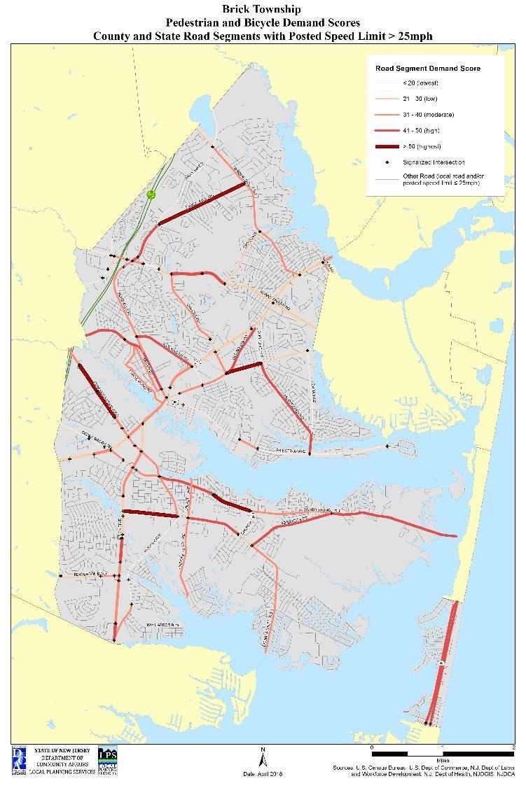
28 BICYCLE & PEDESTRIAN NETWORK PRIORITIZATION
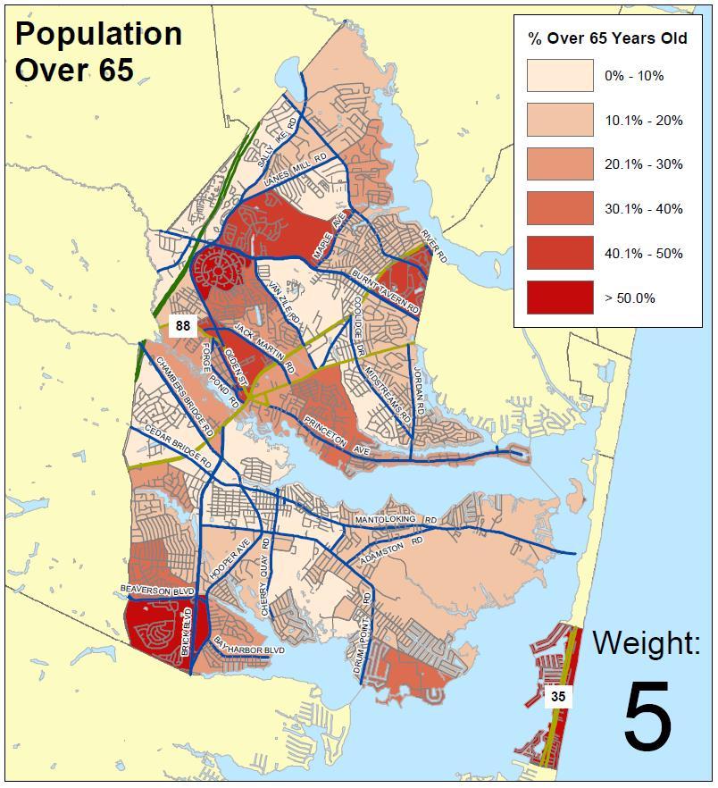
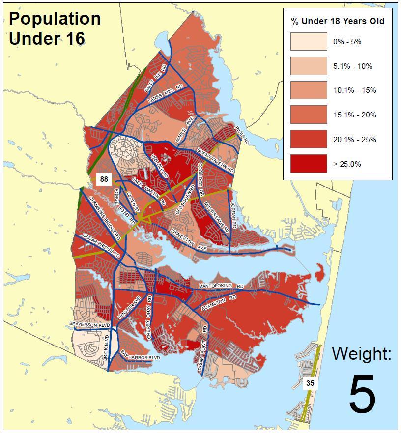
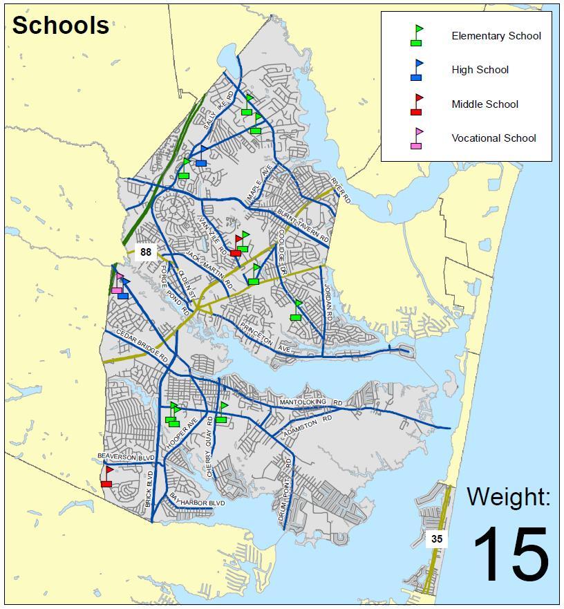
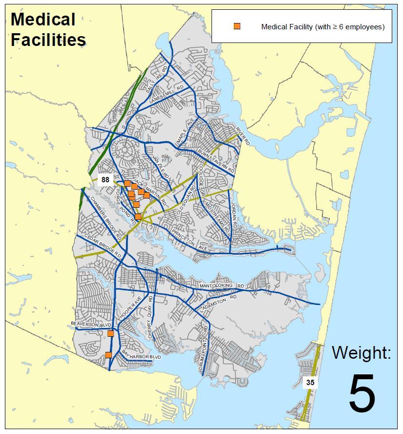
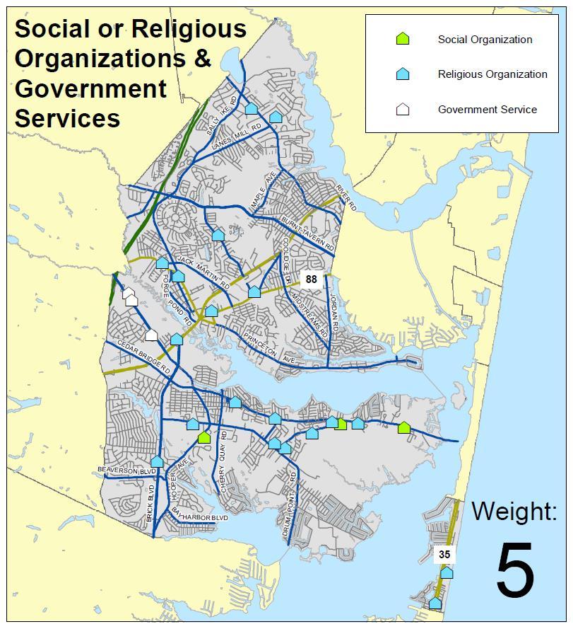
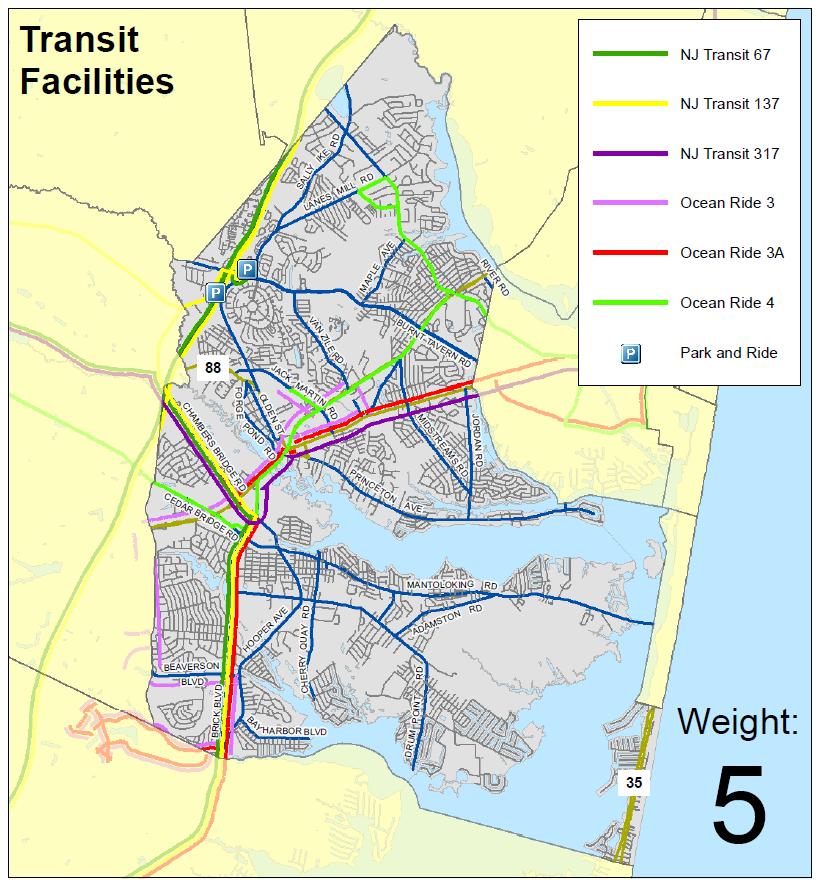
29 BICYCLE & PEDESTRIAN NETWORK PRIORITIZATION Live and Work Land Use Attractors Do these weights seem appropriate? Please fill out a survey to give us your feedback. Category Population Density 15 % Population over 65 5 % Population under 18 5 % Households with no vehicle 5 Median Household Income 5 Employment Density 15 School (elementary to university) 15 (Select one) Category potential score is... Potential Score Too high Too low Appropriate Optional: what is a more appropriate weight? X X 10 Recreation (parks, conservation areas, golf courses, beach access points) 15 Retail 5 Medical Facility 5 Social/Religious Organization or Government Service 5 Transit Facility (bus line or park and ride) 5 Additional Comments:
30 6. NEXT STEPS/QUESTION AND ANSWER Brick Bike Walk
31 NEXT STEPS Incorporate Public Open House II Feedback in Draft Pedestrian & Bicycle Plan Review Draft Pedestrian & Bicycle Plan & Complete Streets Policy with Working Committee Present Draft Pedestrian & Bicycle Plan & Complete Streets Policy to Planning Board
32 QUESTION AND ANSWER
Paxton Timekeeper: Geoffrey Gray-Cornelius Recorder: Maria Connolly 401 Chambers Bridge Road - Brick, NJ Engineering
 Meeting Name: Public Visioning Meeting Date: January 11, 2018 Meeting Facilitator(s): Ramond Joseph & Tara Meeting Time: 2:00 PM 3:30 PM Paxton Timekeeper: Geoffrey Gray-Cornelius Recorder: Maria Connolly
MASTER BICYCLE AND PEDESTRIAN PLAN
 VILLAGE OF NORTHBROOK MASTER BICYCLE AND PEDESTRIAN PLAN DRAFT PLAN OPEN HOUSE May 2, 2018 AGENDA 1. Community Engagement 2. Vision and Goals 3. General Structure of Plan 4. Recommendations Overview 5.
Watertown Complete Streets Prioritization Plan. Public Meeting #1 December 14, 2017
 Watertown Complete Streets Prioritization Plan Public Meeting #1 December 14, 2017 Goals for Public Meeting Overview of MassDOT Complete Streets Funding Program Educate the community on Complete Streets
APPENDIX A: Complete Streets Checklist DRAFT NOVEMBER 2016
 APPENDIX A: Complete Streets Checklist DRAFT NOVEMBER 2016 Complete Streets Checklist MetroPlan Orlando s Complete Streets Checklist is an internal planning tool for staff to further implementation of
REGIONAL BICYCLE AND PEDESTRIAN DESIGN GUIDELINES
 REGIONAL BICYCLE AND PEDESTRIAN DESIGN GUIDELINES November 16, 2011 Deb Humphreys North Central Texas Council of Governments Bicycle and Pedestrian Advisory Committee Snapshot of the Guide 1. Introduction
TOWN OF WILLIAMSTON, SC BICYCLE AND PEDESTRIAN MASTER PLAN TOWN OF WILLIAMSTON, SC BICYCLE AND PEDESTRIAN MASTER PLAN
 TOWN OF WILLIAMSTON, SC BICYCLE AND PEDESTRIAN MASTER PLAN Americans Want Choices 55% of Americans would rather drive less & walk more. Transit use is growing faster than population or highway travel.
NJDOT Complete Streets Checklist
 Background The New Jersey Department of Transportation s Complete Streets Policy promotes a comprehensive, integrated, connected multi-modal network by providing connections to bicycling and walking trip
» Draft Recommendations» Discussion» Next Steps. Plan for Walking and Biking
 SAC Meeting Plan #3 for September Walking and 12, Biking 2018 » Draft Recommendations» Discussion» Next Steps Plan for Walking and Biking » Stakeholder and Public Outreach» Background data collection and
GIS Based Data Collection / Network Planning On a City Scale. Healthy Communities Active Transportation Workshop, Cleveland, Ohio May 10, 2011
 The Purpose of GIS Based Network Planning GIS Based Data Collection / Network Planning Healthy Communities Active Transportation Conference Tuesday, May 10, 2011 10:00 AM Norman Cox, LLA, ASLA. Ann Arbor,
5. RUNNINGWAY GUIDELINES
 5. RUNNINGWAY GUIDELINES These guidelines should be considered collectively when making runningway decisions. A runningway is the linear component of the transit system that forms the right-of-way reserved
Broad Street Bicycle Boulevard Design Guidelines
 Broad Street Bicycle Boulevard Design Guidelines Building from the strategies introduced in the 2013 Bicycle Transportation Plan and community input received thus far, City Transportation Staff have identified
City of Novi Non-Motorized Master Plan 2011 Executive Summary
 City of Novi Non-Motorized Master Plan 2011 Executive Summary Prepared by: February 28, 2011 Why Plan? Encouraging healthy, active lifestyles through pathway and sidewalk connectivity has been a focus
Pedestrian, Bicycle and Traffic Calming Strategic Implementation Plan. January 18, 2011
 Pedestrian, Bicycle and Traffic Calming Strategic Implementation Plan January 18, 2011 Tonight s Agenda Receive update on project Provide feedback on two policy issues Complete Streets Policy Project Prioritization
Transportation Planning Division
 Transportation Planning Division Presentation Outline Study Tasks Recap of Previous Meetings Data Collected Focus Areas within Study Limits Design Principles Tool Box Recommended Concepts Schedule Moving
Goal 3: Foster an environment of partnerships and collaboration to connect our communities and regions to one another.
 Non-Motorized Transportation Plan (NMTP) Draft Vision, Goal and,, Tri-County Regional Planning Commission (TCRPC) Purpose The purpose of the Tri-County Regional Planning Commission (TCRPC) Non-Motorized
PRESS RELEASE San Joaquin Council of Governments
 PRESS RELEASE San Joaquin Council of Governments For Immediate Release February 23, 2018 Contact: Nicole Gorham, 235-0582 gorham@sjcog.org SJCOG Board Awards $19.63 Million in Measure K Bicycle, Pedestrian,
Hennepin County Pedestrian Plan Public Comment Report
 Hennepin County Pedestrian Plan Public Comment Report On May 31, 2013, the draft Hennepin County Pedestrian Plan was released for a 45-day public comment period ending July 15, 2013. The county received
Active Transportation Facility Glossary
 Active Transportation Facility Glossary This document defines different active transportation facilities and suggests appropriate corridor types. Click on a facility type to jump to its definition. Bike
A Matter of Fairness: ROCOG s Environmental Justice Protocol. What is Mobility Limitation?
 No Person Left Behind What is Mobility Limitation? What is the Access Limitation? Environmental Justice population should be provided adequate mobility & access to meet their needs; Identify acceptable
MONTCLAIR SAFE COMPLETE STREETS IMPLEMENTATION PLAN. Monday November 13, 2017 Michael Dannemiller, Principal Engineer NV5, Inc.
 MONTCLAIR SAFE COMPLETE STREETS IMPLEMENTATION PLAN Monday November 13, 2017 Michael Dannemiller, Principal Engineer NV5, Inc. PROJECT TEAM THE OFFICE OF BICYCLE AND PEDESTRIAN PROGRAMS, NEW JERSEY DEPARTMENT
PEDESTRIAN ACTION PLAN
 CITY OF SANTA MONICA PEDESTRIAN ACTION PLAN DRAFT OCTOBER 2015 Safe Streets Santa Monica, December 3, 2015 Beth Rolandson, AICP Principal Transportation Planner Strategic + Transportation Planning, Planning
Vision. Goals and Objectives. Walking
 Vision Walking and biking is an accepted and valued part of everyday life in Portsmouth. People of all ages and abilities include walking and biking as part of their daily activities which helps to make
Agenda. Overview PRINCE GEORGE S PLAZA METRO AREA PEDESTRIAN PLAN
 PRINCE GEORGE S PLAZA METRO AREA PEDESTRIAN PLAN May 28, 2008 Agenda Welcome and introductions Project overview and issue identification Planning context and strengths Design challenges and initial recommendations
SAFE ROUTES TO SCHOOL
 SAFE ROUTES TO SCHOOL Edgewood Elementary School Existing Conditions and ACTION PLAN > Oak Creek - Franklin Joint School District Table of Contents CONTEXT Enrollment Boundaries Enrollment
The DC Pedestrian Master Plan
 The DC Pedestrian Master Plan September 28, 2010 George Branyan Pedestrian Program Coordinator District Department of Transportation Presentation Agenda Scope of the Plan Methodology Recommendations Implementation
EXECUTIVE SUMMARY. Vision
 Vision Walking and bicycling in Salt Lake City will be safe, convenient, comfortable, and viable transportation options that connect people to places, foster recreational and economic development opportunities,
This page intentionally left blank.
 This page intentionally left blank. COMMUNITY Coweta Community Overview Coweta Coweta, a residential community located in Wagoner County, is a suburb of Tulsa situated southeast of the metropolitan area
City of Charlottesville Bicycle and Pedestrian Master Plan Update
 City of Charlottesville Bicycle and Pedestrian Master Plan Update September 17, 2014 I. Welcome and meeting overview II. Project status update III. Network overview IV. Break-out groups Pedestrian Network
Dr. M.L. King, Jr. Street North Complete Streets Resurfacing Opportunities HOUSING, LAND USE, AND TRANSPORTATION COMMITTEE MARCH 22, 2018
 Dr. M.L. King, Jr. Street North Complete Streets Resurfacing Opportunities HOUSING, LAND USE, AND TRANSPORTATION COMMITTEE MARCH 22, 2018 What s Happening The City plans to mill and resurface Dr. M.L.
Memo. Introduction. Memphis STP Pedestrian Sidewalk Project
 Memo Memphis STP Pedestrian Sidewalk Project To: Kyle Wagenshutz, City of Memphis From: Matthew Berkow, Collin Chesston, and Anne Eshleman, Alta Planning + Design Date: June 2014 Re: Photo Inventory Introduction
PEDESTRIAN ACTION PLAN
 ATTACHMENT 2 CITY OF SANTA MONICA PEDESTRIAN ACTION PLAN CITY OF SANTA MONICA PEDESTRIAN ACTION PLAN This page intentionally left blank EXECUTIVE SUMMARY CHAPTER 1 EXECUTIVE SUMMARY Setting the Stage
City of Albert Lea Policy and Procedure Manual 4.10 ALBERT LEA CROSSWALK POLICY
 4.10 ALBERT LEA CROSSWALK POLICY PURPOSE: Pedestrian crosswalks are an integral part of our transportation infrastructure. To be effective and promote safety, marked crosswalks must be installed after
9/25/2018. Multi-Modal Level of Service (MMLOS) Bianca Popescu, Transportation Planner
 Bianca Popescu, Transportation Planner") Multi-Modal Level of Service (MMLOS) Bianca Popescu, Transportation Planner 1 What is MMLOS? Is this a nice place to walk? Is this a nice place to bike? Is transit convenient? Bottom line - Are there options
Multi-Modal Level of Service (MMLOS) Bianca Popescu, Transportation Planner 1 What is MMLOS? Is this a nice place to walk? Is this a nice place to bike? Is transit convenient? Bottom line - Are there options
GIS Based Non-Motorized Transportation Planning APA Ohio Statewide Planning Conference. GIS Assisted Non-Motorized Transportation Planning
 The Purpose of GIS Assisted Network GIS Assisted Non-Motorized Transportation 2011 APA Ohio Statewide Conference Friday, 10:45 AM to Noon Focus on near-term projects wwwgreenwaycollabcom The purpose of
Morristown, NJ Complete Streets Policy
 Morristown, NJ Complete Streets Policy Introduction A Complete Street is defined as a means to provide safe access for all users by designing and operating a comprehensive, integrated, connected multi-modal
Bicycle + Pedestrian Connectivity Gap Analysis
 Accelerated Bridge Program Bicycle + Pedestrian Connectivity Gap Analysis Tuesday, October 11 Shriners Hospital, Boston 6:30-8:00 PM Thursday, October 13 Community Rowing, Brighton 6:30-8:00 PM Tuesday,
ACTIVE TRANSPORTATION
 ACTIVE TRANSPORTATION Mobility 2040 Supported Goals Improve the availability of transportation options for people and goods. Support travel efficiency measures and system enhancements targeted at congestion
Omaha s Complete Streets Policy
 Omaha s Complete Streets Policy (Adopted August 2015) VISION To create great places and enhance our quality of life, the City of Omaha will provide safe, accessible streets for all users. Complete Streets
This page intentionally left blank.
 This page intentionally left blank. COMMUNITY Glenpool Community Overview Glenpool Glenpool is a city of nearly 12,000 residents located in Tulsa County southwest of Tulsa and Jenks. The city is growing
Pedestrian Project List and Prioritization
 To: Kyle Wagenschutz, City of Memphis CC: From: Anne Conlon and John Cock, Alta Planning + Design Date: December, 2014 Re: Project List Development (Task 3.1-3.2) and Project List Prioritization (Task
MAG Town of Cave Creek Bike Study Task 6 Executive Summary and Regional Significance Report
 Page 1 MAG Town of Cave Creek Bike Study Task 6 Executive Summary and Regional Significance Report August 1, 2012 MAG Project #481 Page 2 Task 6 Executive Summary and Regional Significance Report Introduction
Bridgewater Complete Streets Prioritization Plan and Pedestrian Safety Assessment
 Bridgewater Complete Streets Prioritization Plan and Pedestrian Safety Assessment Presented by Luciano Rabito Manager of Complete Streets Presented to Bridgewater, MA Wednesday, April 26, 2017 6:30 P.M.
Designing for Pedestrian Safety in Washington, DC
 Designing for Pedestrian Safety in Washington, DC February 25, 2014 George Branyan Pedestrian Program Coordinator District Department of Transportation DC Journey to work mode split: 2012 Means of Transportation
CONNECTING PEOPLE TO PLACES
 CONNECTING PEOPLE TO PLACES 82 EAST BENCH MASTER PLAN 07 Introduction The East Bench transportation system is a collection of slow moving, treelined residential streets and major arteries that are the
If a person walks within this focus area, these are examples of the places he or she could walk to or from:
 Portland Hillsdale Hillsdale Portland The Hillsdale focus area is located in the City of Portland. It is situated approximately three miles from the City of Portland s downtown, 5.5 miles from the City
Arlington Public Schools Thomas Jefferson Site Evaluation Transportation Networks. Thomas Jefferson Working Group Meeting #6 November 10, 2014
 Arlington Public Schools Thomas Jefferson Site Evaluation Transportation Networks Thomas Jefferson Working Group Meeting #6 November 10, 2014 2 3 INTRODUCTION 4 Goal of our work: Identify and assess multi-modal
Citywide Sidewalk and Crosswalk Programs
 Citywide Sidewalk and Crosswalk Programs Council Meeting October 20, 2015 Presented by Rita Hu and Jamal Mahmoud Program Goals Implement the City s comprehensive plan. Provide pedestrian with safe walking
TRANSPORTATION COMMISSION Agenda Staff Report
 TRANSPORTATION COMMISSION Agenda Staff Report Agenda Item No. 5.a DATE: JULY 31, 2014 TO: FROM: SUBJECT: TRANSPORTATION COMMISSION COMMUNITY DEVELOPMENT DEPARTMENT - PLANNING DRAFT OLYMPIC CORRIDOR PREFERRED
PEDESTRIAN ACTION PLAN
 CITY OF SANTA MONICA PEDESTRIAN ACTION PLAN DRAFT OCTOBER 2015 City Council, February 23, 2016 Beth Rolandson, AICP Principal Transportation Planner Mobility Division, Planning and Community Development
CHAPTER 3: Vision Statement and Goals
 Davidson Walks & Rolls: Active Transportation Master Plan CHAPTER 3 Contents: Overview Vision Statement Measurable Goals Public Outreach CHAPTER 3: Vision Statement and Goals Overview The vision statement
PEDESTRIAN SAFETY IMPROVEMENT EVALUATION GUIDELINE FOR UNCONTROLLED CROSSINGS
 PEDESTRIAN SAFETY IMPROVEMENT EVALUATION GUIDELINE FOR UNCONTROLLED CROSSINGS Traffic Safety Engineering Division Updated: April 2018 EXECUTIVE SUMMARY NDOT Traffic Safety Engineering Division developed
Chapter 14 PARLIER RELATIONSHIP TO CITY PLANS AND POLICIES. Recommendations to Improve Pedestrian Safety in the City of Parlier (2014)
") Chapter 14 PARLIER This chapter describes the current status and future plans for biking and walking in the City of Parlier. RELATIONSHIP TO CITY PLANS AND POLICIES The Parlier General Plan is the primary
Chapter 14 PARLIER This chapter describes the current status and future plans for biking and walking in the City of Parlier. RELATIONSHIP TO CITY PLANS AND POLICIES The Parlier General Plan is the primary
KEARNY MESA COMMUNITY PLAN UPDATE
 KEARNY MESA COMMUNITY PLAN UPDATE January 18, 2018 SUBCOMMITTEE MEETING Mobility Concepts and Urban Design Presentation Outline Mobility Concepts: Multimodal Planning Toolbox Presentation and Activities
City of Birmingham Draft Multi-modal Transportation Plan
 City of Birmingham Draft Multi-modal Transportation Plan City Commission Public Hearing Monday, November 25, 2013 7:30 pm Norman Cox, PLA, ASLA The Greenway Collaborative, Inc. Ann Arbor, Michigan The
Roosevelt Estates Neighborhood Improvements
 Roosevelt Estates Neighborhood Improvements Transportation Alternatives Application May 5 th, 2016 Qualifying Activities Construction of on-road and off-road trail facilities for pedestrians, bicyclists,
Agency Advisory Group Meeting #3 and Walk Audit Anchorage Non-Motorized Plan
 Agency Advisory Group Meeting #3 and Walk Audit Anchorage Non-Motorized Plan Friday, May 18 th Walk Audit 10:00-11:30 AM Meeting 11:30 AM 1:00 PM Municipal Planning Department, 4700 Elmore Road, Training
Board-Approved Funding Awards for Cycle 4 Active Transportation Grant Program Projects (in Order of Project Rankings) Approved on
 Approved on") CAPITAL Large Category Projects Board-Approved Funding Awards for Cycle 4 Active Transportation Grant Program Projects (in Order of Project Rankings) Approved on 07-27-18 1 La Mesa University Ave Pedestrian
CAPITAL Large Category Projects Board-Approved Funding Awards for Cycle 4 Active Transportation Grant Program Projects (in Order of Project Rankings) Approved on 07-27-18 1 La Mesa University Ave Pedestrian
CONNECTIVITY PLAN. Adopted December 5, 2017 City of Virginia Beach
 CONNECTIVITY PLAN Adopted December 5, 2017 City of Virginia Beach CONTENTS 1.0 Background & Purpose... 2 2.0 Existing Inventory & Analysis... 3 ViBe District Existing Walking Conditions... 4 3.0 ViBe District
Complete Streets: Planning, Policy & Performance
 Complete Streets: Planning, Policy & Performance Tell Us About Your CS Experiences Successes Hardships Funding Politics Safety Not every street needs to be complete, but every mode needs a complete network.
NEWMARKET UPHAM S CORNER
 SOUTH STATION Planning Initiative NEWMARKET UPHAM S CORNER COLUMBIA ROAD (P) FOUR CORNERS/GENEVA Working Advisory Group (WAG) Meeting #5 TALBOT AVENUE MORTON STREET BLUE HILL AVE/CUMMINS HWY (P) RIVER
Chapter 13 ORANGE COVE
 Chapter 13 ORANGE COVE This chapter describes the current status and future plans for biking and walking in the City of Orange Cove. RELATIONSHIP TO CITY PLANS AND POLICIES The Orange Cove General Plan
Chapter 2. Bellingham Bicycle Master Plan Chapter 2: Policies and Actions
 Chapter 2 Bellingham Bicycle Master Plan Chapter 2: Policies and Actions Chapter 2: Policies and Actions The Bicycle Master Plan provides a road map for making bicycling in Bellingham a viable transportation
MEETING OF THE CITY OF CONCORD BICYCLE, PEDESTRIAN AND SAFE ROUTES TO TRANSIT PLAN ADVISORY COMMITTEE AGENDA
 MEETING OF THE CITY OF CONCORD BICYCLE, PEDESTRIAN AND SAFE ROUTES TO TRANSIT PLAN ADVISORY COMMITTEE Monday, April 25, 2016 5:30 p.m., Regular Meeting PERMIT CENTER CONFERENCE ROOM 1950 Parkside Drive,
Madison Urban Area and Dane County. Bicycle Transportation Plan Summary. September Introduction. Bicycle Plan Scope and Planning Process
 Bicycle Transportation Plan Summary Madison Urban Area and Dane County Introduction September 2000 Bicycling is an important mode of transportation in the Madison urban area and countywide that is available
11/3/2014 VIA . WALKSacramento has reviewed the Stockton and T Mixed-Use project at 3675 T Street in the
 11/3/2014 VIA EMAIL Antonio Ablog Planning Department City of Sacramento 300 Richards Boulevard Sacramento, CA 95811 RE: Design Review for Stockton and T Mixed-Use (P14-042) Dear Mr. Ablog: WALKSacramento
Corpus Christi Metropolitan Transportation Plan Fiscal Year Introduction:
 Introduction: The Safe, Accountable, Flexible, Efficient Transportation Equity Act: A Legacy for Users (SAFETEA-LU) has continued the efforts started through the Intermodal Surface Transportation Efficiency
Proposed. City of Grand Junction Complete Streets Policy. Exhibit 10
 Proposed City of Grand Junction Complete Streets Policy Exhibit 10 1 City of Grand Junction Complete Streets Policy Vision: The Complete Streets Vision is to develop a safe, efficient, and reliable travel
2015 Florida Main Street Annual Conference. Complete Streets Equal Stronger Main Streets
 WHAT ARE COMPLETE STREETS? CASE STUDIES COMPLETING YOUR MAIN STREET 2015 Florida Main Street Annual Conference St. Petersburg, Florida August 19, 2015 WHAT ARE COMPLETE STREETS? CASE STUDIES COMPLETING
12/4/2016 VIA . RE: Grocery Outlet Del Paso (DR16-328)
") 12/4/2016 VIA EMAIL Ethan Meltzer, Assistant Planner City of Sacramento Community Development Department 300 Richards Blvd, 3 rd Floor Sacramento, CA 95811 RE: Grocery Outlet Del Paso (DR16-328) Dear Mr.
12/4/2016 VIA EMAIL Ethan Meltzer, Assistant Planner City of Sacramento Community Development Department 300 Richards Blvd, 3 rd Floor Sacramento, CA 95811 RE: Grocery Outlet Del Paso (DR16-328) Dear Mr.
Complete Streets Funding Program Project Prioritization Plan
 Funding Program Project Prioritization Plan Location and Type Needs South Street Crosswalk Installation Stripe a new formalized crosswalk across South Street at the Anne T. Dunphy School pedestrian path
Washington County SW Beaverton-Hillsdale Hwy. & SW Scholls Ferry Rd.
 Washington County SW Beaverton-Hillsdale Hwy. & SW Scholls Ferry Rd. SW Beaverton-Hillsdale Hwy. & SW Scholls Ferry Rd. Washington County The SW Beaverton-Hillsdale Hwy & SW Scholls Ferry Rd. focus area
CRESTON ROAD COMPLETE AND SUSTAINABLE STREETS CORRIDOR PLAN
 CRESTON ROAD COMPLETE AND SUSTAINABLE STREETS CORRIDOR PLAN Preferred Plan Community Presentation September 27, 2017 City of El Paso de Robles in partnership with: Local Government Commission, W-Trans,
North Avenue Corridor Study
 North Avenue Corridor Study City Council October 6, 2014 Presentation Outline Project Initiation & Process Corridor Conditions & Issues Vision & Goals Concept Development - Development/Evaluation Implementation
What Is a Complete Street?
 Session 5 Charleen Zimmer, AICP, Zan Associates May 5-7, 2010 What Is a Complete Street? May 2010 5-1 Not a Complete Street More of a Complete Street May 2010 5-2 Benefits of Complete Streets Safety for
STATUS OF 2009 PEDESTRIAN MASTER PLAN (AS OF DECEMBER 2013)
") Appendix P.1 STATUS OF 2009 PEDESTRIAN MASTER PLAN (AS OF DECEMBER 2013) The 2009 Pedestrian Master Plan establishes 21 core recommendations in three goal areas to improve pedestrian transportation in
Appendix P.1 STATUS OF 2009 PEDESTRIAN MASTER PLAN (AS OF DECEMBER 2013) The 2009 Pedestrian Master Plan establishes 21 core recommendations in three goal areas to improve pedestrian transportation in
IBI Group November 5, 2012
 IBI Group Agenda Session 1 3:00 PM Welcome / Sign in 3:10 PM Presentation 3:30 PM Questions? 3:35 PM World Café Discussion 4:45 PM Report on top 3 ideas 4:50 PM Next Steps 5:00 PM Adjourn 2 Agenda Session
El Camino Real Specific Plan. TAC/CAC Meeting #2 Aug 1, 2018
 El Camino Real Specific Plan TAC/CAC Meeting #2 Aug 1, 2018 Land Use Alternatives Goals and Tradeoffs Parks & open space Housing Retail & services Civic spaces Parking Community gathering spaces 3 Alternatives
Bicycle Pedestrian Master Plan Pre Bid Meeting Portsmouth, NH August 15, 2013
 Bicycle Pedestrian Master Plan Pre Bid Meeting Portsmouth, NH August 15, 2013 2005 Master Plan GOAL: Provide for safe and convenient bicycle and pedestrian circulation throughout the City. Develop a city
Perryville TOD and Greenway Plan
 Perryville TOD and Greenway Plan Greenway Glossary Pathway: A bicycle and pedestrian path separated from motorized vehicular traffic by an open space, barrier or curb. Multi-use paths may be within the
Solana Beach Comprehensive Active Transportation Strategy (CATS)
") Solana Beach Comprehensive Active Transportation Strategy (CATS) 3.0 Goals & Policies The Solana Beach CATS goals and objectives outlined below were largely drawn from the Solana Beach Circulation Element
Solana Beach Comprehensive Active Transportation Strategy (CATS) 3.0 Goals & Policies The Solana Beach CATS goals and objectives outlined below were largely drawn from the Solana Beach Circulation Element
City of Sammamish. Welcome. Issaquah-Fall City Road Improvements Project Phase I Design: 242nd Avenue SE to Klahanie Drive SE
 Welcome Welcome to the third community meeting for the Issaquah-Fall City Road Improvements Project. AGENDA 6:00 p.m. Welcome and sign-in 6:10 p.m. Presentation 6:50 p.m. Open house Learn about the roadway
Active Transportation Access to Transit
 Active Transportation Access to Transit Introduction COMO Connect customers access transit service in many ways, including walking, bicycling, riding in a car and being dropped off, and directly boarding
General Plan Circulation Element Update Scoping Meeting April 16, 2014 Santa Ana Senior Center, 424 W. 3rd Street, Santa Ana, CA 92701
 General Plan Circulation Element Update Scoping Meeting April 16, 2014 Santa Ana Senior Center, 424 W. 3rd Street, Santa Ana, CA 92701 Meeting Agenda 1. Purpose of Scoping Meeting 2. Project Overview 3.
MASTER BICYCLE AND PEDESTRIAN PLAN
 WELCOME! PLEASE FEEL FREE TO REVIEW THE EXHIBITS THE PRESENTATION WILL BEGIN AT 6:00 PM VILLAGE OF NORTHBROOK MASTER BICYCLE AND PEDESTRIAN PLAN DRAFT EXISTING CONDITIONS REPORT AND PUBLIC MEETING WELCOME!
This page intentionally left blank.
 This page intentionally left blank. COMMUNITY Catoosa Community Overview Catoosa Catoosa is a city of just over 7,000 residents adjacent to the northeast border of Tulsa. The city contains two major regional
6.0 PEDESTRIAN AND BICYCLE FACILITIES 6.1 INTRODUCTION 6.2 BICYCLE DEMAND AND SUITABILITY Bicycle Demand
 6.0 PEDESTRIAN AND BICYCLE FACILITIES 6.1 INTRODUCTION Bicycle and pedestrian travel along and in the vicinity of the corridor is part of the vision of Somerset and Hunterdon counties and the integrated
Pine Hills Road Pedestrian/Bicycle Safety Study Board of County Commissioners Work Session
 Pine Hills Road Pedestrian/Bicycle Safety Study Board of County Commissioners Work Session February 20, 2018 Meeting Agenda Study Overview Existing Conditions Access Management Potential Gateway Features
Bicycle and Pedestrian Chapter TPP Update Overview. TAB September 20, 2017
 Bicycle and Pedestrian Chapter TPP Update Overview TAB September 20, 2017 Bicycling & Walking in the Twin Cities Where are we now? The Bike-Pedestrian system Current trends New developments Where are we
WELCOME. Thank you for joining us at the Second Public Workshop for the Carlsbad Pedestrian Master Plan. We look forward to receiving your feedback.
 City of Carlsbad Pedestrian Master Plan: WELCOME WELCOME Please Sign In Provide Input at Flip Charts Review Boards Presentation of Draft Plan Thank you for joining us at the Second Public Workshop for
Bicycle and Pedestrian Facilities Toolbox (Excerpt from Figure 3.1)
") Appendix B Neighborhood Connections Summaries This Appendix is a supplement to the information presented in Chapter 3 Connect People. The Appendix includes a summary or profile for each of the proposed
Appendix B Neighborhood Connections Summaries This Appendix is a supplement to the information presented in Chapter 3 Connect People. The Appendix includes a summary or profile for each of the proposed
Bicycle Boulevards and Neighborhood Greenways
 Bicycle Boulevards and Neighborhood Greenways Traffic Safety is Improving for Everyone 90 80 70 60 50 40 30 20 10 0 PORTLAND: TOTAL TRAFFIC FATALITIES 1986-2008 1986 1987 1988 1989 1990 1991 1992 1993
PRINCE GEORGE S PLAZA METRO AREA PEDESTRIAN PLAN
 PRINCE GEORGE S PLAZA METRO AREA PEDESTRIAN PLAN May 28, 2008 Agenda Welcome and introductions Project overview and issue identification Planning context and strengths Design challenges and initial recommendations
TOWN OF PORTLAND, CONNECTICUT COMPLETE STREETS POLICY
 TOWN OF PORTLAND, CONNECTICUT COMPLETE STREETS POLICY I. VISION, GOALS & PRINCIPLES VISION To improve the streets of Portland making them safer and more accessible for all users including pedestrians,
TRAFFIC ACTION PLAN. North Central Neighborhood CITY OF SAN MATEO
 TRAFFIC ACTION PLAN North Central Neighborhood CITY OF SAN MATEO Draft February 2017 Table of Contents Introduction... 1 The Traffic Forum Process... 4 Neighborhood Traffic Issues... 6 Neighborhood Recommendations
Tonight is for you. Learn everything you can. Share all your ideas.
 Strathcona Neighbourhood Renewal Draft Concept Design Tonight is for you. Learn everything you can. Share all your ideas. What is Neighbourhood Renewal? Creating a design with you for your neighbourhood.
CITY OF COCOA BEACH 2025 COMPREHENSIVE PLAN. Section VIII Mobility Element Goals, Objectives, and Policies
 CITY OF COCOA BEACH 2025 COMPREHENSIVE PLAN Section VIII Mobility Element Goals, Objectives, and Policies Adopted August 6, 2015 by Ordinance No. 1591 VIII MOBILITY ELEMENT Table of Contents Page Number
Bicycle-Pedestrian Master Plan: Chapters 3 and 4 Distribution
 Bicycle-Pedestrian Master Plan: Chapters 3 and 4 Distribution Finksburg Planning and Citizens Council March 22, 2018 Overview Progress Citizen Outreach Vision Chapter 3 - Existing Conditions Chapter 4
Physical Implications of Complete Streets Policies
 Presentation Overview Physical Implications of Complete Norm Cox, ASLA, LLA Landscape Architect Ann Arbor, Michigan, 10:45 to Noon What Are Complete Streets? What Matters to Bicyclists and Pedestrians
City of Jacksonville Mobility Fee Update
 City of Jacksonville Mobility Fee Update 2017 Preliminary Analysis May 3, 2017 Carnival Cruise lines photo credit Presentation Overview Public Outreach Process Pedestrian and Bicycle Master Plan Study
Urbana Pedestrian Master Plan
 Urbana Pedestrian Master Plan Recommendations Gabe Lewis, Transportation Planner Champaign County Regional Planning Commission November 15, 2018 Public Meeting #2 Public Input Round #1 Thank You! 10 public