GATEWAY BUSINESS PARK TRANSPORTATION DEMAND MANAGEMENT PROGRAM
|
|
|
- Molly Pearson
- 5 years ago
- Views:
Transcription


1 Draft GATEWAY BUSINESS PARK TRANSPORTATION DEMAND MANAGEMENT PROGRAM Prepared for: Chamberlin Associates Prepared by: Fehr & Peers SF May 4, 2009
2 TABLE OF CONTENTS 1. Introduction... 1 Executive Summary... 1 Background... 1 Purpose... 1 Project Description... 1 Regulatory Setting Existing Transportation System... 5 Transit Service... 5 Bicycle Facilities... 8 Pedestrian Facilities Transportation Demand Management Program... 9 Mode Share Assumptions Required Measures Additional City of South San Francisco Measures Phasing Enforcement and Financing Compliance with Guidelines and Effectiveness City of South San Francisco Guidelines City/County Association of Governments of San Mateo County Guidelines APPENDICES Appendix A: TDM Program Additional Information and Brochures Appendix B: TDM Program Provision Assumptions Appendix C: Project Trip Generation and Employee Estimates Appendix D: City of South San Francisco Travel Demand Management Requirements Appendix E: City/County Association of Governments of San Mateo County Transportation Demand Management Measures
3 LIST OF FIGURES Figure 1 Site Location Context Map... 2 Figure 2 Project Site Plan... 4 Figure 3 Existing Transit Routes and Bicycle Facilities... 6 Figure 4 Proposed TDM Site Plan Figure 5 Proposed Pedestrian Circulation Plan... 15
4 LIST OF TABLES Table 1 Gateway Business Park Transportation Demand Program Measures... 9 Table 2 Compliance with Guidelines and TDM Program Effectiveness Table B1 TDM Program Quantity Assumptions Table C1 Project Trip Generation Estimates Table C2 Project Employee Estimates Table E1 City/County Association of Governments of San Mateo County Transportation Demand Management Measures... 44
5 Gateway Business Park Transportation Demand Management Program Final, April INTRODUCTION EXECUTIVE SUMMARY This report presents a Transportation Demand Management (TDM) program for the proposed Gateway Business Park located at the intersection of Oyster Point and Gateway Boulevards in South San Francisco, California. The report identifies TDM measures to achieve 40 percent alternative mode use credits for the Park s employees, as required by the City of South San Francisco (SSF). The TDM Program also satisfies the City/County Association of Governments of San Mateo County (C/CAG) requirement, mitigating all new peak-hour trips based on the C/CAG trip credit guidelines. BACKGROUND With the Gateway Business Park Master Plan, Chamberlin Associates has proposed a re-envisioning of a successful, yet underutilized, corporate campus location. The new vision for this 22.6-acre site provides for the phased and incremental replacement of low-scale buildings with a modern, energy-efficient, higher density development that prioritizes the pedestrian and provides significant open space opportunities. The higher density development also represents the highest and best use of this campus in this high-demand life sciences employment cluster. The new Business Park, at build-out, would provide approximately 1,200,000 square feet of office and research and development space, replacing the existing 284,000 square feet. This report presents a TDM Program to identify measures to reduce the number of single-occupant automobile trips and the total traffic impact generated by the proposed project. PURPOSE The purpose of this TDM Program is to develop a set of strategies, measures, and incentives to encourage future employees of Gateway Business Park to walk, bicycle, use public transportation, carpool, or use other alternatives to driving alone when traveling to and from work. In general, TDM supports more mobility by using existing transportation systems, boosts economic efficiency of the current transportation infrastructure, improves air quality, saves energy, and reduces traffic congestion. Convenience and cost are the primary factors that affect a person s choice of transportation mode. Measures that work well for some people or types of businesses do not work as well for others. Therefore, an effective TDM Program needs to provide multiple options and incentives that are flexible enough to allow customization to meet the varied needs of individual employees and employers. This program presents an array of proven strategies and measures used in the Bay Area under a flexible implementation plan that can meet the needs of the future tenants of Gateway Business Park. PROJECT DESCRIPTION The project site is located at the intersection of Oyster Point and Gateway Boulevards in South San Francisco, CA, as shown on Figure 1. Office and research and development (R&D) tenants would occupy the Business Park. 1
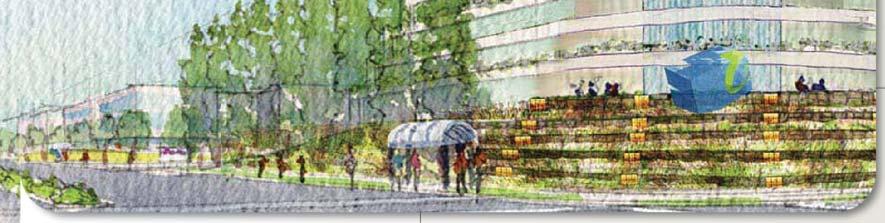
6 GULL DR MITCHELL AVE BAYSHORE BLVD OYSTER POINT BLVD BLVD FORBES BLVD DR GRANDVIEW ALLERTON AVE GRAND AVE San Francisco Bay AIRPORT BLVD GATEWAY UTAH AVE SISTER CITIES BLVD HILLSIDE BLVD GRAND AVE EL CAMINO REAL SNEATH LN CHESTNUT AVE LAWNDALE BLVD South San Francisco BART San Bruno BART South San Francisco Caltrain Station 101 ECCLES AVE San Francisco International Airport MISSION RD BLVD WESTBOROUGH July 2008 SF \graphics\ LEGEND: = Gateway Business Park (Project) = BART = Caltrain N NOT TO SCALE Gateway Business Park Transportation Demand Management Program PROJECT LOCATION FIGURE 1
7 Gateway Business Park Transportation Demand Management Program Final, April 2009 The proposed project will provide approximately 3,100 total parking spaces. The floor area ratio (FAR) of the proposed project will be A site plan for the proposed project is shown on Figure 2. The proposed project is estimated to generate 1,640 AM peak hour trips, 1,500 PM peak hour trips, and 11,130 daily trips from an estimated 4,080 employees. 1 REGULATORY SETTING The TDM Program is based on guidelines provided by SSF 2 and C/CAG 3, the local Congestion Management Agency for San Mateo County. City of South San Francisco Guidelines The SSF guidelines for TDM Programs require that all projects that generate greater than 100 daily trips obtain a required alternative mode use goal of 28 percent, based on a list of 15 required TDM Program measures. This alternative mode use goal is required to be monitored and reported to SSF through annual surveys of employee travel habits. More stringent alternative mode use goals are required for projects that seek densities above set FAR thresholds, based on land use. The proposed project is located within the Gateway Specific Plan District. The maximum allowable FAR in this district is 1.25, and the proposed project is seeking this maximum. This FAR, in exceeding the citywide office park TDM threshold of 1.0 FAR, requires an alternative mode use share of 40 percent per SSF guidelines. City/County Association of Governments of San Mateo County Guidelines C/CAG guidelines require developments that generate 100 or more net new peak hour trips to implement TDM measures that have the capacity to mitigate all new peak hour trips, based on C/CAG programmatic trip credits. 1 See Appendix C for proposed project trip generation and employee estimates. 2 City of South San Francisco, Municipal Code, Chapter , City/County Association of Governments of San Mateo County, Revised C/CAG Guidelines for the Implementation of the Land Use Component of the Congestion Management Program,
8 to/from 101 Oyster Point Boulevard Gateway Boulevard Oyster Point Boulevard ( Under Construction) Oyster Point Boulevard ( Under Construction) Legend of Proposed Elements Buildings Central Commons Parking Structures Gateway Business Park Master Plan Area Boundary 4 Eccles Ave. Arrival Areas This plan represents a concept framework for the campus and is intended only to convey a vision for relationships and elements. N NOT TO SCALE Gateway Business Park Transportation Demand Management Program PROJECT SITE PLAN July 2008 SF \graphics\ FIGURE 2

 provide commuter rail and bus service near the")

9 Gateway Business Park Transportation Demand Management Program Final, April EXISTING TRANSPORTATION SYSTEM This chapter describes the existing transportation system in the project vicinity, including the transit services and facilities, bicycle facilities, and pedestrian facilities. TRANSIT SERVICE The project site is not directly served by rail or bus transit services; however, three transit agencies (Caltrain, BART, and SamTrans) provide commuter rail and bus service near the project site. Pedestrian accessibility to BART and Caltrain stations is poor and inconvenient and no SamTrans bus service exists east of US-101 in South San Francisco. The project site must rely on supplementary shuttle services to connect employees on campus with BART and Caltrain stations. Because no direct connection exists to serve employees who use SamTrans, these employees must connect with existing Caltrain or BART stations to ride shuttles to and from work. The existing transit services are shown on Figure 3 and described in detail below. Rail Service Caltrain and BART provide rail transportation services to a variety of regional destinations such as San Francisco, Oakland, and San Jose. BART service frequencies average about once every 15 minutes during the AM (6:00 9:00 AM) and PM (4:00 7:00 PM) commute periods and about once every 20 minutes during off-peak periods. Caltrain frequencies vary between 20, 35, and 40 minutes in the northbound direction during the AM commute period (6:00 9:00 AM). During the PM commute period (4:00 7:00 PM), southbound frequencies vary between 20 and 40 minutes. Less frequent service, about once every hour, is provided during off-peak periods. Caltrain The current South San Francisco Caltrain Station is located underneath the interchange of East Grand Avenue and US-101 approximately 1.1 miles from the project site. Only local and some limited (skip-stop) trains stop at this station, approximately every twenty minutes to an hour. There are no plans to have express (Baby Bullet) service stops at this station now or in the future. In the near future, Caltrain and the City of South San Francisco plan on moving the South San Francisco Caltrain station several hundred feet to the south to greatly improve pedestrian, bike, transit/shuttle accessibility, as well as passenger waiting area and platform amenities. A new pedestrian underpass at this station is planned. BART In addition to Caltrain, South San Francisco employees have access to BART, a regional, rail rapid transit service provided by the Bay Area Rapid Transit District (BART). The South San Francisco BART Station is located approximately 3.7 miles from the project site. In 2003, BART completed its South San Francisco BART station near El Camino Real and the Kaiser Permanente Medical Facility on the west side of the City of South San Francisco. 5


10 Legend Gateway Business Park Master SitePlan Area BART Caltrain SamTrans Bus Route Existing Caltrain Station Bay Trail Shuttle Service to Transit Existing Bicycle Facility Proposed Bicycle Path Future Ferry Terminal Existing Shuttle Stop Gateway Business Park Site Proposed Ferry Terminal at Oyster Point Marina Downtown Pt. San Bruno Source: Gateway Business Park Master Plan, Chamberlin Associates. Source: South San Francisco General Plan N NOT TO SCALE Gateway Business Park Transportation Demand Management Program EXISTING TRANSIT SERVICES July 2008 SF \graphics\ FIGURE 3


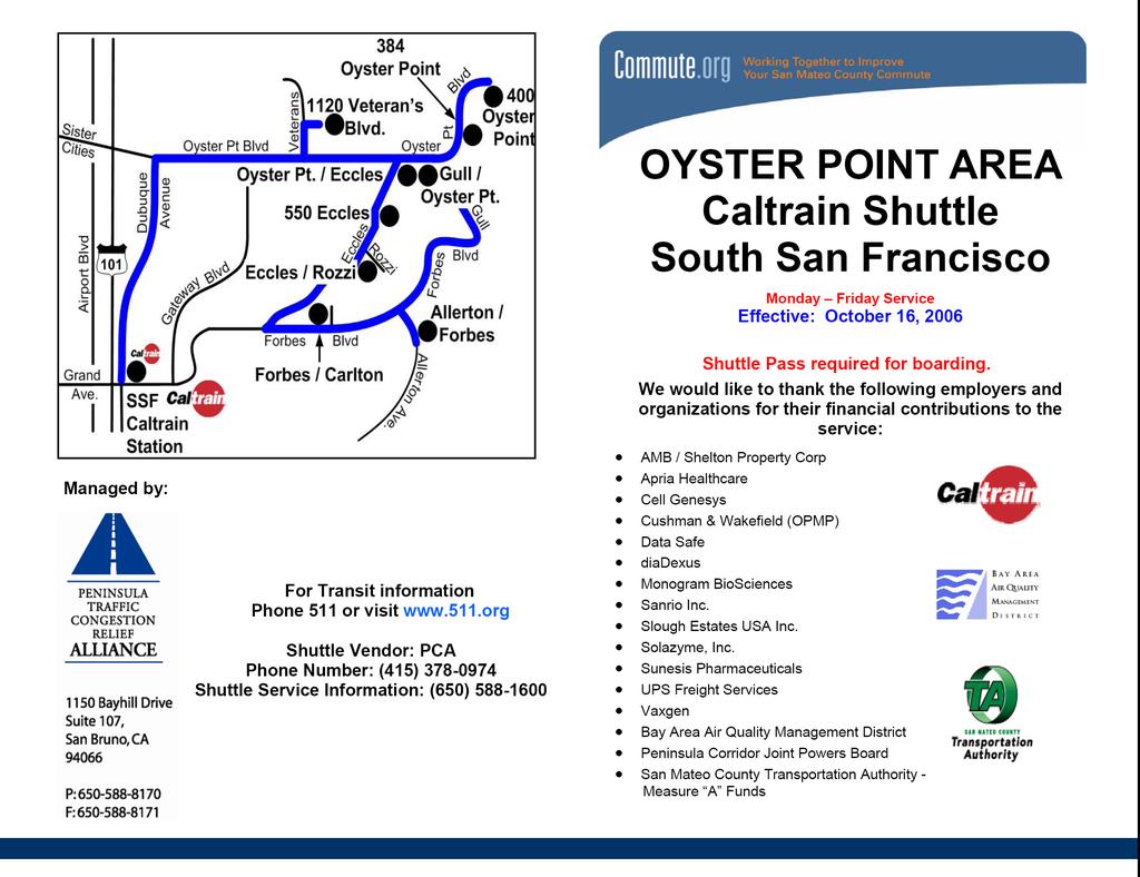
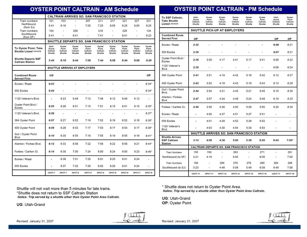
11 Gateway Business Park Transportation Demand Management Program Final, April 2009 Shuttle Service As shown in Figure 3, the East of 101 Area relies on supplementary shuttle services to connect employees with the BART and Caltrain stations. The Peninsula Traffic Congestion Relief Alliance operates the Oyster Point Shuttles to BART and Caltrain. Genentech also operates a shuttle in the Gateway area. No SamTrans bus service exists east of US-101 in South San Francisco. Because no direct connection exists to serve employees who use SamTrans, these travelers must connect with existing Caltrain or BART stations to ride shuttles to and from the East of 101 Area. Appendix A includes timetables for these shuttle services. Oyster Point BART Shuttle The Oyster Point BART Shuttle provides service between the South San Francisco BART station and the Oyster Point area office buildings with eight shuttles from/to the station, approximately every 24 minutes in the morning (6:32 AM 9:17 AM) and nine shuttles, approximately every 27 minutes in the evening (3:36 PM 7:09 PM). The closest shuttle stop locations are at 1120 Veterans Boulevard, approximately 0.1 miles from the project site, and at the intersection of Oyster Point Boulevard and Eccles Avenue, approximately 0.2 miles from the project site. Currently there are limited sidewalks from the project site to both shuttle stops. However, there is a new crosswalk planned across Oyster Point Boulevard at the Veterans Boulevard crossing, and new sidewalks planned along Oyster Point Boulevard in conjunction with the 180 and 200 Oyster Point Boulevard developments. Oyster Point Caltrain Shuttle The Oyster Point Caltrain Shuttle provides service between the South San Francisco Caltrain station and the Oyster Point area office buildings every 28 minutes in the morning (5:44 AM 9:29 AM) and approximately every 34 minutes in the evening (3:14 PM 7:00 PM). Shuttle stops are shared with the Oyster Point BART Shuttle, as outlined above. Gateway Area Caltrain Shuttle The Gateway Area Caltrain Shuttle, operated by Genentech, provides service between the Millbrae Caltrain Station and the Gateway area office buildings with ten shuttles, approximately every 20 minutes in the morning (6:37 AM 9:36 AM) and ten shuttles, approximately every 30 minutes in the evening (3:33 PM 6:53 PM). The closest shuttle stop location is at 700 Gateway Boulevard, directly in front of the project site. 7


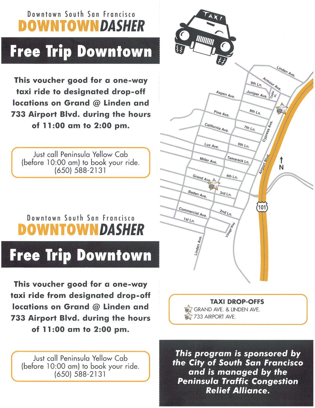
12 Gateway Business Park Transportation Demand Management Program Final, April 2009 Bus Service SamTrans is the transit authority for San Mateo County that provides both local and regional bus service, primarily to San Mateo County locations. SamTrans does not provide direct service to the project site or areas east of Highway 101. The closest bus stop is located at the intersection of Airport Boulevard/Baden Avenue, approximately 1.3 miles from the project site. SamTrans Route 292 provides bus service between the Hillsdale Shopping Center, in San Mateo, and the Transbay Terminal, in downtown San Francisco. This bus route operates along Airport Boulevard, within South San Francisco, and stops at Airport Boulevard/Baden Avenue. The hours of operation are 5:00 AM to 2:00 AM on weekdays and weekends. Buses run approximately every 25 minutes. Taxi Service The Downtown Dasher Taxi Service provides free taxi vouchers between South San Francisco job sites east of Highway 101 and the downtown area of South San Francisco in the middle of the day (11:00 AM 2:00 PM). The Downtown Dasher is operated by Peninsula Yellow Cab of South San Francisco and managed by the Alliance. Employees who wish to use the service need employer-provided vouchers and trip reservations before 10:00 AM. Currently there is no cost to employers for providing the Downtown Dasher service. Appendix A includes a brochure with more information on this program. BICYCLE FACILITIES Bicycle facilities include bike paths (Class I), bike lanes (Class II), and bike routes (Class III). Bike paths are paved trails that are separated from roadways. Bike lanes are lanes on roadways designated for use by bicycles with striping, pavement legends, and signs. Bike routes are roadways that are designated for bicycle use by signs only and may or may not include additional pavement width for cyclists. Near the project site, bike lanes are provided on Sister Cities Boulevard, Oyster Point Boulevard, Gateway Boulevard, and East Grand Avenue, as shown on Figure 3. Gateway Boulevard and Airport Boulevard are also designated as bicycle routes. The San Francisco Bay Trail, part of a planned 400-mile system of trails encircling the Bay, is located close to the project site and provides access to the Oyster Point Marina. PEDESTRIAN FACILITIES Pedestrian facilities include sidewalks, crosswalks, trails, and pedestrian signals. Near the project site, sidewalks are located on both sides of Oyster Point Boulevard. Limited crosswalks are provided at nearby signalized intersections. A segment of the San Francisco Bay Trail is located to the north of the project site, approximately 0.2 miles away, and hugs the Bay shoreline, as shown on Figure 3. The Bay Trail is a public pedestrian and bicycle trail that is planned to extend around the entire San Francisco Bay. Currently, there are gaps in the trail to the north, above Brisbane, and just south of South San Francisco. 8
13 Gateway Business Park Transportation Demand Management Program Final, April TRANSPORTATION DEMAND MANAGEMENT PROGRAM The TDM Program elements for the Gateway Business Park TDM Program include on-site amenities that encourage the use of alternative modes of travel, participation in associations that promote commute alternatives to the single-occupant vehicle, and parking measures. The menu of strategies includes appropriate TDM measures that will satisfy SSF and C/CAG guidelines. Table 1 summarizes the TDM measures, which are described in detail below. Figure 4 presents a summary of the proposed general locations for the site design features. Final locations for TDM measures will be determined with building tenants. TABLE 1 GATEWAY BUSINESS PARK TRANSPORTATION DEMAND PROGRAM MEASURES TDM Measure Description City of South San Francisco Municipal Code Required Site Design Features Secure Bicycle Storage Direct Route to Transit Free Carpool/Vanpool Parking Passenger Loading Zones Pedestrian Connections Preferential Carpool Parking Preferential Vanpool Parking Showers/Clothes Lockers Shuttle Program Information Boards and Kiosks Bicycle storage will be provided on-site as racks, cages, lockers, or (A, B) inside, at discretion of Landlord. A well-lit path or sidewalk will be provided on site to the most direct (E) route to the nearest transit or shuttle stop from the building. Free parking spaces will be provided for carpools and vanpools (F, K) A loading zone for vanpool and carpool rides will be provided near the building entrances. Lighted paths and sidewalks will be provided between the buildings, parking areas, and Gateway and Oyster Point Boulevards. Preferential parking spaces will be provided for carpools. Preferential parking spaces will be provided for vanpools. Six shower facilities with clothing lockers will be provided throughout the campus, with shower access available to all employees. The tenants will be able to use the Oyster Point BART Shuttle to/from the South San Francisco BART Station, and the Gateway Area Caltrain and Oyster Point Caltrain Shuttles to/from the South San Francisco Caltrain Station. The building lobbies, employee break rooms, or other common areas will include permanent displays of commute alternative information (I) (E, J) (K) (K) (M) (N) (H) Required Supporting Features Designated Employer Contact ETC (TDM Coordinators) The tenants of the building will designate an individual TDM Coordinator (or may share a coordinator with other tenants) (D) 9
14 Gateway Business Park Transportation Demand Management Program Final, April 2009 Carpool/Vanpool Matching Services Guaranteed Ride Home Program Promotional Programs (Quarterly) Transportation Options for Visitors (Maps and Schedules); On-site Assistance Transportation Management Association Participation (Alliance) Biannual Employee Commute Survey New Employee Orientation Packet Commute Alternatives Brochure Rack (Maps and Schedules) Spare the Air Promotion Rideshare Week Promotion The TDM Coordinator will provide ride-matching services for carpool and vanpool users through 511.org and/or an internal program. Employees will be able to utilize the Alliance s free guaranteed ride home program for emergencies via taxicabs or rental cars. The TDM Coordinator will provide new employee orientation packets, flyers, posters, , and educational programs on a quarterly basis. This may include a lunchtime transportation options fair with the Alliance and transportation providers participating. Shuttle maps and schedules will be posted on campus and on the tenant websites for visitor use, if available. The TDM Coordinator will offer on-site assistance to visitors. The tenants will join the Peninsula Traffic Congestion Relief Alliance. The TDM Coordinator will administer a biannual survey to determine alternative transportation mode use and opportunities to TDM strategy adjustments. Transportation options will be outlined in the tenant s employee handbook, or on an intranet site, etc. Brochure racks will be provided in public spaces within each building. The TDM Coordinator will promote this program to combat air pollution in the San Francisco Bay Area (when some transit agencies will sponsor free transit rides). The TDM Coordinator will promote carpooling and vanpooling as an alternative form of transportation during a Rideshare Promotion Week (C) (G) (L) (L) (O) (O) (L) (L) (L) (L) Additional Site Design Features Land Dedication for Transit/Bus Shelter Bicycle Connections Land will be dedicated for transit/bus shelters to protect employees from South San Francisco winds. Bicycle connections will be provided to bicycle parking areas from bicycle routes (E) (B) Additional Supporting Features Subsidized Transit Tickets On-Site Amenities (from e-concierge) Subsidized Bicycle Commuters The tenants will subsidize transit tickets by offering pre-tax payroll deductions for Commuter Checks or directly providing Commuter Checks as an employee benefit. Employees will be made aware of services that can be provided on-site, for example: dry cleaning, groceries, prescriptions, and catering, through e-concierge or other similar services. The tenants will subsidize bicycle commuters by offering $20-a-month, tax-free reimbursement for their employees for bicycle-related expenses (A) (F) (A) 10
15 Gateway Business Park Transportation Demand Management Program Final, April 2009 On-Site and Nearby Open Space On-Site Transit Sales Nearby Amenity: Childcare Center Open space will be provided for on-site recreation opportunities. The Bay Trail recreation opportunities are also easily accessed from the campus. Transit ticket sales will be provided on-site via Commuter Check direct deposit. Employees can use nearby YMCA childcare center (J) (F) (F) Nearby Amenity: Cafe Existing off-site Specialties Café (F) Telecommuting Downtown Dasher Video Conferencing Centers The tenants will provide opportunities and the ability for their employees to work off-site when feasible. The tenants will be able to use the free Downtown Dasher lunchtime taxi service. Conference rooms on campus (at least one per building) will support video conferencing (H) (J) (J) Motorcycle Parking Dedicated motorcycle parking spaces will be provided in the garages (J) Flextime Develop Transportation Action Plan with the Transportation Management Association Connections to Future Ferry Service Tenants will allow employees to work a varied work schedule where feasible. Each tenant will develop an action plan with the Alliance. Tenants will be able to use shuttles with connections to a future ferry service (J) (J) (J) Source: City of South San Francisco, 2008, City/County Association of Governments San Mateo County 2004, and Fehr & Peers,
16 to/from 101 Gateway Boulevard * Oyster Point Boulevard BR BR IB S V IB S V * IB S V BR L CVP 180 Oyster Point Boulevard ( Under Construction) IB S V BC MP 200 Oyster Point Boulevard ( Under Construction) CVP N NOT TO SCALE IB S V BC MP LEGEND: BC = Bicycle Cage * IB S V BR CVP BR BC L MP BC CVP MP Locations to be determined with tenants. Gateway Business Park Master Plan Area Boundary Eccles Ave. This plan represents a concept framework for the campus and is intended only to convey a vision for relationships and elements. BR * IB L CVP S V MP = Bicycle Rack = Shuttle = Proposed Shuttle Stop = Bike Connection = Information Board = Carpool/Vanpool Loading Area = Carpool/Vanpool Parking = Showers/Lockers = Video Conferencing Center = Motorcycle Parking Gateway Business Park Transportation Demand Management Program SUGGESTED LOCATIONS FOR TDM STRATEGIES Sept 2008 SF \graphics\ FIGURE 4
17 Gateway Business Park Transportation Demand Management Program Final, April 2009 MODE SHARE ASSUMPTIONS Based on a review of TDM Programs and employee travel surveys for comparable sites in South San Francisco, the TDM Program assumes the following composition of the required 40 percent alternative mode share for the 4,080 campus employees: Transit: 14% (571 employees) Carpool: 14% (571 employees) Vanpool: 4.5% (184 employees) Bicycle: 2.5% (102 employees) Flextime: 2.5% (102 employees) Telecommute: 2% (82 employees) Motorcycle/Scooter: 0.5% (20 employees) The quantity and distribution of the TDM strategies presented in this chapter reflect this assumption. Should employee surveys suggest the 40 percent mode share has a different distribution, the allocation of the TDM strategies, and additional or substitute strategies, may be appropriate. REQUIRED MEASURES Site Design Features Bicycle Parking The Landlord will provide bicycle parking based on tenant needs. Parking provision options include bicycle racks, bicycle lockers, bicycle cages in the parking garages, or in-office accommodation. Figure 4 includes proposed bicycle parking locations. Direct Route to Transit Well-lit paths will be provided utilizing the most direct route to the nearest transit or shuttle stop from the different buildings. These paths are shown in Figure 5. Free Parking for Carpools and Vanpools Free parking will be provided for all carpools and vanpools. Passenger Loading Zones A passenger loading zone for a carpool or vanpool drop-off will be provided convenient to all buildings. Parking stalls convenient to building entrances will be time-restricted to allow vehicles to drop-off/pick-up passengers. See Figure 4 for potential drop-off areas. 13
18 Gateway Business Park Transportation Demand Management Program Final, April 2009 Pedestrian Connections On-site pedestrian facilities will be provided, including on-street sidewalks and lighted paths between the buildings, parking areas, and Gateway and Oyster Point Boulevards. These connections are shown in Figure 5. Preferential Carpool and Vanpool Parking Ten percent of garage parking spaces will be reserved for carpools and vanpools and will be located in premium and convenient locations, per City requirements. These preferential spaces will discourage single-occupant vehicle trips and improve accessibility for those sharing vehicles. Based on the anticipated mode share for the Business Park, these spaces maybe underused. Therefore, carpool/vanpool spaces may have single occupancy vehicles allowed after 10 AM, thereby also promoting flextime. Shower and Locker Facilities Shower and locker facilities will help promote cycling as an alternative commute option. Shower facilities (men s and women s) will be provided in three of the campus buildings, assuring all tenants have access. Each shower facility will include one shower and 8 clothing lockers, available on a first-come, first-served basis. Shuttle Program In addition to the existing shuttle stop, two new stops are proposed for the Gateway Business Park: one on Gateway Boulevard and one on Oyster Point Boulevard, as shown in Figure 4. Caltrain and BART shuttles provide service from the South San Francisco Caltrain and BART stations to the Gateway Business Park. Information Boards and Kiosks An information kiosk/board will be located in employee break rooms or other common gathering areas (i.e., building lobby). The kiosk will contain information on shuttles, SamTrans, Caltrain, BART, VTA, Downtown Dasher, e-concierge online amenities, vanpool organizations, bicycle routes, and other transportation options information. The TDM Coordinator will be in charge of updating information. Supporting Features TDM Coordinators The lease agreement between the owner and tenants will state that the tenants will designate a TDM Coordinator for the site. The TDM Coordinator will promote the TDM Program, activities, and features to all employees, and will conduct the monitoring/reporting process. The TDM Coordinator will develop an on-site transportation information center with SamTrans, BART, and Caltrain schedules and maps. The TDM Coordinator will provide information via new employee orientation packets, flyers, posters, , and/or educational programs. The TDM Coordinator s role will also include actively marketing alternative mode use, administering the carpool and vanpool matching program, promoting special programs such as Bike-to-Work Day or Carpool Week, and overseeing the guaranteed ride home program (working with a local taxi service or rental car agencies). The TDM Coordinator will also conduct biannual employee commute surveys to identify the need for mode specific promotional material and educational programs. 14


19 Legend A Gateway Frontage Buildings B Internal Site Buildings C D E F G H Parking Structures Oyster Point Buildings Central Commons Street Frontage Arrival Areas Parking Structure Frontage Central Spine & Amenity Spaces Parking Structure Connections C Connection to the Street Public Realm at Street Frontage G C B G D D Under Construction C H 1 2 C B E Under Construction 1 E 1 3 A 2 3 A 4 A 3 A Oyster Point Boulevard F F Gateway Boulevard N Source: Gateway Business Park Master Plan, Chamberlin Associates. NOT TO SCALE Gateway Business Park Transportation Demand Management Program PEDESTRIAN CIRCULATION July 2008 SF \graphics\ FIGURE 5
20 Gateway Business Park Transportation Demand Management Program Final, April 2009 Carpool/Vanpool Matching Services Carpools in the Bay Area consist of two or more people riding in one vehicle for commute purposes. Vanpools provide similar commuting benefits as carpools, though a vanpool consists of seven to 15 passengers, including the driver, and the vehicle is either owned by one of the vanpoolers or leased from a vanpool rental company. The TDM Coordinator will provide an Internet link to the 511.org Rideshare website to access ride matching services. The TDM Coordinator will also administer an on-site carpool and vanpool matching service for employees and maintain a list of available vanpools that provide service between the Gateway Business Park offices and various points in the Bay Area. Guaranteed Ride Home A common reason that employees do not use alternative modes (i.e., carpool, vanpool, or transit) is the inability to leave work unexpectedly for a family emergency or the fear of being stranded if they need to work late. One TDM element that allays these fears is the Alliance s Guaranteed Ride Home program. With this program, employees can use a taxi service, rental car or other means to get home and the employer pays for the service. The lease agreement will state that the tenants must participate in the Alliance s Guaranteed Ride Home program, which will be managed by the TDM Coordinator. Employees who wish to use the service will contact the TDM Coordinator to make the travel arrangements. Promotional Programs Promotional programs include new employee orientation packets outlining alternative transportation options and an orientation program, which will explain the importance and benefits of using alternative transportation modes. Other annual or quarterly events could include commute fair where various transit organizations can set up marketing booths during lunch and encourage other events like Bike to Work Day. Transportation Options for Visitors (Maps and Schedules); On-site Assistance Visitors to Gateway Business Park will also be able to use the on-site transportation amenities. Maps and schedules will be available online and tenant TDM Coordinators will offer on-site assistance. TMA Membership Tenants will participate with the Peninsula Traffic Congestion Relief Alliance, with provides ongoing support for alternative commute programs. The TDM Coordinator will work with the Alliance to create a Transportation Action Plan for each tenant. Biannual Employee Commute Survey The TDM Program will be performance-based and the alternative mode use will be monitored annually, beginning one year after tenant occupancy. The alternative mode use and general perceptions of the TDM Program will come from statistically valid employee surveys. The TDM Coordinator may use information from the employee surveys to adjust existing or implement new TDM Program measures. The TDM Coordinator will submit the annual survey to the SSF Economic Development Director. The TDM Coordinator will also work with SSF Economic Development staff to document the effectiveness of the TDM Program through triennial reporting. Independent consultants, retained by the City and paid for by the tenants, will measure, through observation, the alternative mode use achieved at Gateway Business Park every three years, beginning three years after tenant occupancy. If the alternative mode use goals are not achieved, the TDM Coordinator will provide an explanation of how and why the goal has not been reached and a detailed description of additional measures that will be 16
21 Gateway Business Park Transportation Demand Management Program Final, April 2009 adopted to attain the required mode use. The independent consultants will submit the findings of the triennial survey to the SSF Economic Development Director. New Employee Orientation Packet Orientation packets will provide information on TDM Program benefits. Packets will include (but not be limited to) information on carpool/vanpool options, shuttle services, Downtown Dasher, and bicycle options. Commute Alternatives Brochure Rack (Maps and Schedules) Brochure racks will be in public spaces in buildings, for example break rooms or lobbies. They will provide information on transportation options and upcoming events, such as Bike to Work Day. The TDM Coordinator will maintain and update the brochure racks with current information. Spare the Air Promotion The TDM Coordinator will notify employees of Spare the Air days (as declared for the Bay Area region) and associated transit promotions. Prizes may be offered for non-sov travel on these days to encourage participation. Rideshare Week Promotion The TDM Coordinator will promote and encourage ridesharing during a Rideshare Week Promotion. The TDM Coordinator may offer prizes as incentives for ridesharing. ADDITIONAL CITY OF SOUTH SAN FRANCISCO MEASURES Site Design Features Land Dedication for Transit/Bus Shelter Shuttle pull out areas and shelters will be provided at campus shuttle stops. Harsh wind conditions in South San Francisco create uncomfortable waiting conditions; therefore, shelters are necessary to encourage transit ridership. Bicycle Connections Bicycle connections will be provided to connect bicycle routes to building entrances and bicycle storage facilities. These connections are shown on Figure 4. Supporting Features Subsidized Transit Tickets The TDM Coordinator will facilitate tenant participation in the Commuter Check program ( which provides vouchers that can be redeemed online for transit passes and tickets, vanpool fares, or park and ride lot costs at BART/Caltrain stations. The Commuter Check credit will be provided tax-free to employees that ride transit to work in amounts up to $230 per month (amount determined by 17
22 Gateway Business Park Transportation Demand Management Program Final, April 2009 the IRS (IRS Tax Code Section 132(f) - Qualified Transportation Fringe)). Tenants may also elect to subsidize fully Commuter Checks as an employee benefit. 511.org has an outreach program to help employers get started. Subsidy for Bicycle Commuters The TDM Coordinator will facilitate tenant participation in bicycle commuter subsidies via the Commuter Check for Bicycling Program (see As of January 1, 2009, employees who regularly use their bicycles to get to and from work are eligible for up to a $20-a-month, tax-free reimbursement from their employers for bicycle-related expenses. Employers will in turn be able to deduct the expense from federal taxes. On-site Amenities Tenants will make employees aware of on-site amenities that may be provided by e-concierge, or other similar online service providers. E-Concierge is an online service that provides food, catering, groceries, banking, real estate, haircut and salon, laundry and dry cleaning, errands, daycare, and many more convenient amenities by reservation/ request on work sites (see Appendix A includes a flyer with more information on this service. On-site Retail or Childcare The Landlord or Tenant will provide an on-site retail, restaurant, or childcare establishment, which is still to be determined. On-site Open Space Parking has been consolidated into structures allowing for a Central Commons area open space for employees and visitors to gather and exercise. On-site Transit Sales Commuter Checks will be available online through Commuter Check Direct, a service that will deliver the transit passes directly to the employee s home or office. Nearby Childcare Center The nearby Peninsula Family YMCA childcare center at 559 Gateway Boulevard will provide convenient childcare. The YMCA center has capacity for 100 infants, toddlers, and preschool children. Nearby Café and Restaurant Specialties Café, located at 701 Gateway Boulevard, provides breakfast, lunch, and catering options for tenants and is within walking distance. The Embassy Suites Hotel Two Fifty Restaurant, located at 250 Gateway Boulevard, provides upscale dining within walking distance. Telecommuting Where feasible, tenants will provide the opportunity for their employees to work off-site with the necessary infrastructure, i.e. Internet access and internal data access. 18
23 Gateway Business Park Transportation Demand Management Program Final, April 2009 Downtown Dasher The Downtown Dasher is a free midday taxi service that operates between the hours of 11 AM and 2 PM. The reservation-only service offers transportation to two stops in the downtown area of South San Francisco. The Downtown Dasher taxi service requires a voucher and a trip reservation, which can be arranged through the TDM Coordinator. Video Conferencing Centers The use of live video connections may serve as a substitute for physical meetings, reducing the amount of vehicle trips to the Business Park. Video connections will be feasible in all campus conference rooms, with computer and video technology to be provided by the tenants. Motorcycle/Scooter Parking Twenty motorcycle parking spaces will be provided in the parking garages. Up to eight motorcycles can park within a vehicle parking space, making this parking an efficient use of space in the garages. Flextime Where feasible, tenants will offer flextime options such as compressed workweeks and alternative work hours. As noted above, employees arriving after 10 AM will be eligible to park in available carpool and vanpool preferential parking locations. Connections to Future Ferry Service South San Francisco ferry service is expected to begin in September Tenants will be able to access the ferry service via expanded shuttles to/from the ferry terminal. PHASING The Gateway Business Park redevelopment will be incremental and phased. As such, the implementation of the TDM Program will be incremental to reflect the number and nature of employees within each development phase. The full TDM program will be deployed with full build out. Appendix B presents a set of provision assumptions associated with each strategy. This includes provision requirements such as carpool/vanpool parking (10% of parking provisions). These assumptions may be referenced in each phase to determine incremental site design features as appropriate. Most of the supporting features are existing (requiring only tenant enrollment) or will be established with each new tenant. ENFORCEMENT AND FINANCING Landlord will prepare lease language for all tenants that requires the designation of a TDM Coordinator(s) for the Business Park (multiple tenants may share one TDM Coordinator), membership in the Alliance, and compliance with and implementation of the TDM Program. Tenants may implement the TDM Program with different additional measures, so long as the programmatic credits from the replacement measures meet or exceed the programmatic credits of the measures identified by this plan, as described in Appendix E. Tenants not meeting requirements may be subjected to penalties per the lease. The Gateway Business Park TDM Program will be funded through tenant payments and Alliance grants, which pay up to 50 percent of bicycle facility and Guaranteed Ride Home Program costs. 19
24 Gateway Business Park Transportation Demand Management Program Final, April COMPLIANCE WITH GUIDELINES AND EFFECTIVENESS As noted in the Regulatory Setting section of Chapter 1, the TDM Program must comply with SSF and C/CAG Guidelines. These guidelines and effectiveness standards are described below. CITY OF SOUTH SAN FRANCISCO GUIDELINES The SSF Guidelines require the Gateway Business Park TDM Program to achieve a 40 percent alternative mode use credit. According to the SSF Guidelines, the TDM Program will implement all required and several additional TDM measures. Based on calculations of C/CAG trip credits, as shown in Table 2, the TDM Program will provide for 4,459 alternative mode use credit trips, which represents slightly more than 40 percent of the estimated 11,130 total daily project trips. Assumptions for the TDM Program quantities are included in Appendix B. The TDM Program will therefore meet SSF TDM requirements by providing all required measures and meeting the required 40 percent alternative mode use based on the calculated credits. CITY/COUNTY ASSOCIATION OF GOVERNMENTS OF SAN MATEO COUNTY GUIDELINES C/CAG Guidelines require the Gateway Business Park TDM Program to have the capacity to reduce fully the demand for new peak hour trips. According to C/CAG Guidelines, the amount of new peak hour trips 4 is calculated based on standard rates developed by the Institute of Transportation Engineers (ITE). Applying ITE rates, the proposed project is estimated to generate 1,250 new AM peak hour trips, 1,130 new PM peak hour trips, and 8,420 new daily trips from an estimated 4,080 employees. 5 According to C/CAG trip credits, the Gateway Business Park TDM Program will have the capacity to reduce the demand for peak hour trips by 4,459 trips, as shown in Table 2. This is in excess of the maximum number of AM or PM peak hour trips calculated using ITE estimates (1,250 and 1,130 trips, respectively). The Gateway Business Park TDM Program therefore exceeds C/CAG requirements. 4 New is defined as in excess of existing land use trip generation. 5 See Appendix C for project trip generation and employee estimates. 20
25 Gateway Business Park Transportation Demand Management Program Final, April 2009 TABLE 2 COMPLIANCE WITH GUIDELINES AND TDM PROGRAM EFFECTIVENESS TDM Measure City of South San Francisco Municipal Code Amount C/CAG Credit Rate C/CAG Trip Credits Required Site Design Features Bicycle Parking Long Term (Class I) (A) 36 n/a n/a Bicycle Parking Short Term (Class II) (B) 26 n/a n/a Total Secure Bicycle Storage (A, B) Direct Route to Transit (E) 3 n/a n/a Free Carpool/Vanpool Parking (F, K) 100% n/a n/a Passenger Loading Zones (I) 6 n/a n/a Pedestrian Connections (E, J) Preferential Carpool Parking (K) Preferential Vanpool Parking (K) Showers/Clothes Lockers (M) Additional Credit for Combination with Bicycle Lockers (A, B, M) Shuttle Program (N) Additional Credit for Combination with Guaranteed Ride (G, N) Home Program Information Boards and Kiosks (H) Required Supporting Features Carpool/Vanpool Matching Services (C) Designated Employer Contact ETC (TDM Coordinator) (D) Guaranteed Ride Home Program (G) 1, ,326 Promotional Programs (Quarterly) (L) Transportation Options for Visitors (Maps and Schedules); Onsite Assistance (L) Transportation Management Association Participation (Alliance) (O) Biannual Employee Commute Survey (O) New Employee Orientation Packet (L) Commute Alternatives Brochure Rack (Maps and Schedules) (L) Spare the Air Promotion (L) Rideshare Week Promotion (L) Subtotal of Required Measures 3,662 trip credits 21
26 Gateway Business Park Transportation Demand Management Program Final, April 2009 Additional Site Design Features Land Dedication for Transit Shelter (E) 3 n/a n/a Bicycle Connections (B) Additional Supporting Features Subsidized Transit Tickets (A) On-Site Amenities (from E-Concierge) (F) Subsidized Bicycle Commuters (A) On-Site Amenities (to be determined) (F) On-Site Open Space (J) On-Site Transit Sales (F) Nearby Amenity: Childcare Center (J) Nearby Amenity: Cafes/Restaurants (J) Telecommuting (H) Downtown Dasher (J) Video Conferencing Centers (J) Motorcycle Parking (J) 20 n/a n/a Flextime (J) Develop Transportation Action Plan with the Transportation Management Association (J) Connections to Future Ferry Service (J) Additional Credit for Providing Ten or more TDM Program Measures (J) Subtotal of Additional Measures Total TDM Program Measures 4,459 40% Daily Alternative Mode Use Trip Credit Target 4,450 Source: City/County Association of Governments of San Mateo County, 2004; City of South San Francisco, 2007; and Fehr & Peers,
27 APPENDIX A: TDM PROGRAM ADDITIONAL INFORMATION AND BROCHURES 23
 378-0974 Shuttle Service Information: (650) 588-1600 OYSTER POINT AREA BART SHUTTLE SOUTH SAN FRANCISCO Monday Friday Service Effective: January 2, 2008")
28 Managed by: Commute Information Hotline: Or Online: Shuttle Vendor: PCA Phone Number: (415) Shuttle Service Information: (650) OYSTER POINT AREA BART SHUTTLE SOUTH SAN FRANCISCO Monday Friday Service Effective: January 2, 2008 Shuttle Pass required for boarding. We would like to thank the following employers and organizations for their financial contributions to the shuttle service: AMB/Shelton Property Corp Apria Healthcare Cell Genesys Cushman & Wakefield (OPMP) Data Safe diadexus Monogram BioSciences Sanrio Inc. Slough Estates USA Inc. Solazyme, Inc. Sunesis Pharmaceuticals UPS Freight Services VaxGen Bay Area Air Quality Management District San Mateo City/County Association of Governments San Mateo County Transit District San Mateo County Transportation
29 OYSTER POINT BART - AM Schedule SHUTTLE DEPARTS SOUTH SAN FRANCISCO BART OYSTER POINT BART - PM Schedule SHUTTLE DEPARTS EMPLOYERS Shuttle Departs South San Francisco BART 6:32 6:55 7:17 7:47 8:02 8:32 8:47 9:17 SHUTTLE ARRIVES AT EMPLOYERS Oyster Point Blvd. / Eccles 3:10 3:55 4:25 4:40 5:10 5:25 5:55 6:10 6: Oyster Point 3:11 3:56 4:26 4:41 5:11 5:26 5:56 6:11 6: Veteran s Blvd. 6:45 7:08 7:30 8:00 8:15 8:45 9:00* 9:30* 400 Oyster Point 3:12 3:57 4:27 4:42 5:12 5:27 5:57 6:12 6:45 Oyster Point Blvd. / Eccles 6:47 7:10 7:32 8:02 8:17 8:47 9:02* 9:32* Gull / Oyster Point Blvd. 3:14 3:59 4:29 4:44 5:14 5:29 5:59 6:14 6: Oyster Point 6:49 7:12 7:34 8:04 8:19 8:49 9:04* 9:34* Allerton / Forbes Blvd. 3:16 4:01 4:31 4:46 5:16 5:31 6:01 6:16 6: Oyster Point 6:50 7:13 7:35 8:05 8:20 8:50 9:05* 9:35* Forbes / Carlton Ct. 3:18 4:03 4:33 4:48 5:18 5:33 6:03 6:18 6:51 Gull / Oyster Point Blvd. Allerton / Forbes Blvd. 6:52 7:15 7:37 8:07 8:22 8:52 9:07* 9:37* 6:54 7:17 7:39 8:09 8:24 8:54 9:09* 9:39* Eccles / Rozzi 3:19 4:04 4:34 4:49 5:19 5:34 6:04 6:19 6: Eccles 3:20 4:05 4:35 4:50 5:20 5:35 6:05 6:20 6:53 Forbes / Carlton Ct. 6:56 7:19 7:41 8:11 8:26 8:56 9:11* 9:41* 1120 Veteran s Blvd. 3:21 4:06 4:36 4:51 5:21 5:36 6:06 6:21 6:54 Eccles / Rozzi 6:57 7:20 7:42 8:12 8:27 8:57 9:12* 9:42* SHUTTLE ARRIVES AT SOUTH SAN FRANCISCO BART 550 Eccles 6:58 7:21 7:43 8:13 8:28 8:58 9:13* 9:43* Shuttle Arrives South San Francisco BART Station: 3:36 4:21 4:51 5:06 5:36 5:51 6:21 6:36* 7:09* OP-A1 OP-B1 OP-A2 OP-B2 OP-A3 OP-B3 OP-A4 OP-B4 OP- A11 OP- A12 OP- B11 OP- A13 OP- B12 OP- A14 OP- B13 OP- A15 OP- B14 * Shuttle does not return to BART Station * Shuttle does not return to employer area Revised: December 14, 2007 Revised: December 14, 2007
30
31
32 Millbrae Caltrain/BART GenenBus - Gateway Campus Please note: Only Caltrain information is listed. NB/SB: Northbound / Southbound, BB: "Baby Bullet" Express train; G: Route extends to Gilroy Limited: Does not stop at all stations - see Caltrain schedule, Local: Train stops at ALL stations. Stop Location: Bus Bay 6, on the BART Side of the station Train Type Train Number Train Arrival Depart Millbrae Station 690 Gateway B Gateway NB BB 305 6:24 AM 6:26 AM 6:37 AM 6:39 AM 6:40 AM NB BB 309 6:45 AM 6:50 AM 7:01 AM 7:03 AM 7:04 AM NB Limited 207 6:59 AM 7:02 AM 7:13 AM 7:15 AM 7:16 AM NB Limited/BB 211/313 7:17 AM / 7:24 AM 7:26 AM 7:37 AM 7:39 AM 7:40 AM NB BB 319 7:45 AM 7:50 AM 8:02 AM 8:04 AM 8:05 AM NB Limited (G) 217 7:59 AM 8:02 AM 8:13 AM 8:15 AM 8:16 AM NB Limited/BB 221/323 7:17 AM / 8:24 AM 8:26 AM 8:37 AM 8:39 AM 8:40 AM NB BB 329 8:45 AM 8:50 AM 9:02 AM 9:04 AM 9:05 AM NB Limited (G) 227 8:59 AM 9:02 AM 9:13 AM 9:15 AM 9:16 AM NB Limited 231 9:17 AM 9:25 AM 9:36 AM 9:38 AM 9:39 AM NB Limited 233 9:41 AM 9:53 AM - 10:08 AM - NB Limited :41 AM 10:53 AM - 11:08 AM - NB Limited :41 AM 11:53 AM - 12:08 PM Gateway B Gateway Arrive Millbrae Station Train Departure Train Number Train Type - 1:34 PM - 1:49 PM 1:55 PM 252 SB Limited - 2:34 PM - 2:49 PM 2:55 PM 256 SB Limited - 3:10 PM - 3:25 PM 3:31 PM 158 SB Local 3:30 PM 3:31 PM 3:33 PM 3:49 PM 3:55 PM 260 SB Limited 4:00 PM 4:01 PM 4:03 PM 4:19 PM 4:25 PM 362 SB BB 4:25 PM 4:26 PM 4:28 PM 4:43 PM 4:49 PM / 4:56 PM 368/266 SB BB 4:50 PM 4:51 PM 4:53 PM 5:08 PM 5:14 PM 270 SB Limited (G) 5:05 PM 5:06 PM 5:08 PM 5:24 PM 5:30 PM 372 SB BB 5:25 PM 5:26 PM 5:27 PM 5:43 PM 5:49 PM / 5:56 PM 378/276 SB BB 5:45 PM 5:46 PM 5:48 PM 6:06 PM 6:14 PM 280 SB Limited 6:05 PM 6:06 PM 6:08 PM 6:24 PM 6:30 PM 382 SB BB 6:25 PM 6:26 PM 6:28 PM 6:43 PM 6:49 PM / 6:56 PM 386/284 SB BB 6:50 PM 6:51 PM 6:53 PM 7:08 PM 7:14 PM 288 SB Limited - 7:32 PM - 7:47 PM 7:54 PM / 7:53 PM 190 / 189 SB/NB Local - 8:32 PM - 8:47 PM 8:54 PM 192 SB Local - 9:32 PM - 9:47 PM 9:54 PM 194 SB Local Please contact the gride Hotline with any questions at x55000, or gride-d@gene.com Visit our website at gride.gene.com. Schedule subject to change upon notice. Issue Date: March


33 EMERGENCY RIDE HOME PROGRAM Are you ready to improve recruitment and retention rates, reduce parking congestion, and attract employees from a wider area, while providing a subsidized, low cost benefit to your employees? Do it all with the Alliance s Emergency Ride Home Program Most employees choose to drive their own personal vehicle to work because they don t want to be stranded at work should an emergency arise. With the Emergency Ride Home program, employees are given the assurance that, in the case of an emergency, they will be provided with a free taxi ride or a 24-hour car rental. We pay 75% of the ride! The participating employer pays the remaining 25%. Historically, program costs remain very low because emergencies are infrequent. The Alliance can help you design easy administration policies that prevent program abuse. Employer cost of one Emergency Ride Home: average $12 Trusting your employer will be there for you in an emergency: Priceless The Alliance does all the work. If you have any questions or are unsure if your company could benefit from this or other no to low cost commute programs, contact us at or via at alliance@commute.org.

34
35

36 Bicycle and Pedestrian Safety Program Attention Bicycle Commuters Get A Free One Hour Bike And Pedestrian Safety Workshop At Your Jobsite This Fun, Energizing Workshop Includes: Tips on including Bicycling as a safe, stress relieving commute mode Coverage of Traffic Laws for Bicyclists, Pedestrians, and Motorists around Bicyclists and Pedestrians Basic Bicycle Maintenance Tips Free bicycle related Door Prizes Ask Your Employer To Give Us A Call, And The ALLIANCE Will Do The Rest!!! If you would like more information on the Bicycle and Pedestrian Safety Program, please call The ALLIANCE at , visit our website at or us at ALLIANCE@commute.org Rev 2 Belmont Brisbane Burlingame Colma Daly City E. Palo Alto Foster City Half Moon Bay Millbrae Pacifica Redwood City San Bruno San Carlos San Mateo S. San Francisco
June 3, Attention: David Hogan City of San Mateo 330 W. 2oth Avenue San Mateo, CA 94403
 June 3, 2015 Attention: David Hogan City of San Mateo 330 W. 2oth Avenue San Mateo, CA 94403 Regarding: PA # 15-030, Bridgepointe Shopping Center 2202 Bridgepointe Parkway, APN 035-466-10 Dear David: Enclosed
Millbrae Serra Station Development Millbrae, California
 Millbrae Serra Station Development Millbrae, California Transportation Demand Management Plan Prepared for: Mr. Vincent A. Muzzi, Millbrae Serra Station, LLC June 15, 2016 Hexagon Transportation Consultants,
Magnolia Place. Traffic Impact Analysis. Prepared for: City of San Mateo. Prepared by: Hexagon Transportation Consultants, Inc.
 Magnolia Place Traffic Impact Analysis Prepared for: City of San Mateo Prepared by: Hexagon Transportation Consultants, Inc. Updated January 4, 2010 Table of Contents 1. Introduction...1 2. Existing Conditions...6
Annual Report. Year Master Plan. Francisco May 2013
 Annual Report Genentech Facilities Ten 2013 Year Master Plan Prepared for the City of South San Francisco May 2013 Genentech Master Plan Annual Report Table of Contents Introduction... 3 Genentech Master
CPC Parking Lot Riverside Drive. Transportation Rationale
 CPC Parking Lot Transportation Rationale Prepared By: NOVATECH Suite 200, 240 Michael Cowpland Drive Ottawa, Ontario K2M 1P6 September 2015 Novatech File: 114093 Ref: R-2015-153 Table of Contents 1.0 INTRODUCTION...
ATTACHMENT 4 - TDM Checklist. TDM Checklist Overview
 ATTACHMENT 4 - TDM Checklist TDM Checklist Overview The proposed checklist rates developments on the degree to which they are TDM and transit supportive. Points are assigned based on the level of transit
SETTINGS AND OPPORTUNITIES MOBILITY & ACCESS
 7 mobility & access how do people use el camino what is it like to drive on el camino/to park along el camino what is the pedestrian experience like what is the role of transit along the corridor what
Transportation 6. A. Transit Center Circulation and Access. 1. Transit Center Circulation
 Transportation 6 This chapter describes the transportation system in and around the Hillsdale Station Area, with a focus on the Transit Center at the relocated Hillsdale Caltrain Station. The transportation
Bike San Mateo County San Mateo County Bicycle Plan Recommendations August 30, 2010
 Policy and Procedures Develop and Implement a Complete Streets Policy to comply with DD-64-R1 and AB1358 Commencing January 1, 2011, AB1358 requires that the legislative body of a city or county, upon
Solana Beach Comprehensive Active Transportation Strategy (CATS)
") Solana Beach Comprehensive Active Transportation Strategy (CATS) 3.0 Goals & Policies The Solana Beach CATS goals and objectives outlined below were largely drawn from the Solana Beach Circulation Element
Solana Beach Comprehensive Active Transportation Strategy (CATS) 3.0 Goals & Policies The Solana Beach CATS goals and objectives outlined below were largely drawn from the Solana Beach Circulation Element
2018 Transportation Survey October 17, Prepared by:
 Transportation Survey October 17, Prepared by: Overview Methodology Systemwide results Strengths/Weaknesses by mode Importance of possible improvements Conclusions Methodology 500 Chittenden County residents
Roads and Vehicular Traffic Design Principles. Roads and Vehicular Traffic Recommendations
 CIRCULATION AND PARKING roads and vehicular traffic The Campus Master Plan updates the campus transportation network through a multi-modal approach that encourages walking and biking while improving vehicular
Planning Commission Staff Report
 Planning Commission Staff Report DATE: June 19, 2014 TO: SUBJECT: Planning Commission 2014 Genentech Annual Report, including a review of the Genentech Campus Master Plan (P05-0141), as required under
CONNECTING PEOPLE TO PLACES
 CONNECTING PEOPLE TO PLACES 82 EAST BENCH MASTER PLAN 07 Introduction The East Bench transportation system is a collection of slow moving, treelined residential streets and major arteries that are the
University of Victoria Campus Cycling Plan Terms of Reference. 1.0 Project Description
 University of Victoria Campus Cycling Plan Terms of Reference 1.0 Project Description The Campus Cycling Plan, a first for the University, will provide a comprehensive and coordinated approach to support
San Mateo County Comprehensive Bicycle and Pedestrian Plan Open House
 San Mateo County Comprehensive Bicycle and Pedestrian Plan Open House October 28, 2010 Presented to San Mateo County residents and interested parties by Lauren Ledbetter, Alta Planning + Design Matt Haynes,
EXECUTIVE SUMMARY... vii 1 STUDY OVERVIEW Study Scope Study Area Study Objectives
 Contents EXECUTIVE SUMMARY... vii 1 STUDY OVERVIEW... 1-1 1.1 Study Scope... 1-1 1.2 Study Area... 1-1 1.3 Study Objectives... 1-3 2 EXISTING CONDITIONS... 2-1 2.1 Existing Freeway Conditions... 2-4 2.1.1
Memorandum. Fund Allocation Fund Programming Policy/Legislation Plan/Study Capital Project Oversight/Delivery Budget/Finance Contract/Agreement Other:
 Memorandum Date: November 20, 2017 To: Transportation Authority Board From: Eric Cordoba Deputy Director Capital Projects Subject: 12/5/17 Board Meeting: San Francisco Freeway Corridor Management Study
ROADSOADS CONGESTION HAMPTON SYSTEMYSTEM MANAGEMENT. Part II Roadway Congestion Analysis Mitigation Strategies and Evaluation
 HAMPTON ROADSOADS CONGESTION MANAGEMENT SYSTEMYSTEM Part II Roadway Congestion Analysis Mitigation Strategies and Evaluation Presented by: Dwight Farmer, PE Deputy Executive Director, Transportation April
Dear City Council Members,
 From: Bob Kenyon [mailto: ] Sent: Monday, February 08, 2016 10:20 AM To: City Clerk Subject: Please prioritize Caltrain and a complete transit network Thank you for prioritizing bringing BART to San Jose
TRAVEL PLAN: CENTRAL EUROPEAN UNIVERSITY CAMPUS REDEVELOPMENT PROJECT TRAVEL PLAN. Central European University Campus Redevelopment Project.
 TRAVEL PLAN Central European University Campus Redevelopment Project Page 1 Table of Contents Introduction... 3 Background... 7 Building Users... 7 Transportation in Community Consultation... 7 Summary
Key objectives of the survey were to gain a better understanding of:
 3 COMMUNITY INPUT Community input is an essential part of corridor studies. For the SR 87 corridor study, VTA staff conducted an extensive online survey of people living and commuting along the corridor.
ZONING ADMINISTRATOR AGENDA
 COMMUNITY DEVELOPMENT SERVICES PLANNING SERVICES ZONING ADMINISTRATOR AGENDA December 16, 2015 CITY HALL, COUNCIL CHAMBERS 3:00 PM 1. 610 Walnut Street Use Permit application for non-conforming parking
FROM: CITY MANAGER DEPARTMENT: PLANNING AND COMMUNITY ENVIRONMENT DATE: OCTOBER 4, 2004 CMR:432:04
 TO: HONORABLE CITY COUNCIL FROM: CITY MANAGER DEPARTMENT: PLANNING AND COMMUNITY ENVIRONMENT DATE: OCTOBER 4, 2004 CMR:432:04 SUBJECT: FINANCE COMMITTEE RECOMMENDATION TO ADOPT TRANSPORTATION STRATEGIC
 MEMORANDUM - CITY OF PASADENA Department Of Transportation DATE: OCTOBER 21, 2008 TO: ENVIRONMENTAL ADVISORY COMMISSION FROM: ~ FRED C. DOCK, DIRECTOR OF TRANSPORTATION SUBJECT: UPDATE ON DEPT. OF TRANSPORTATION
Purpose and Need. Chapter Introduction. 2.2 Project Purpose and Need Project Purpose Project Need
 Chapter 2 Purpose and Need 2.1 Introduction The El Camino Real Bus Rapid Transit (BRT) Project (Project) would make transit and other transportation improvements along a 17.6-mile segment of the El Camino
MOUNTAIN HOUSE SPECIFIC PLAN I 9.1 INTRODUCTION ASSUMPTIONS TRANSPORTATION FACILITIES TRANSPORTATION IMPROVEMENTS PHASING 9.
 CHAPTER NINE: TRANSPORTATION AND CIRCULATION 9.1 INTRODUCTION 9.1 9.2 ASSUMPTIONS 9.1 9.3 TRANSPORTATION FACILITIES 9.1 9.4 TRANSPORTATION IMPROVEMENTS PHASING 9.3 LIST OF FIGURES LIST OF TABLES Figure
Transportation, Parking & Roads
 Transportation, Parking & Roads Design Carolina North as a walkable community Design the transportation system and development patterns (i.e., urban design elements such as density, building design, mix
CITY OF COCOA BEACH 2025 COMPREHENSIVE PLAN. Section VIII Mobility Element Goals, Objectives, and Policies
 CITY OF COCOA BEACH 2025 COMPREHENSIVE PLAN Section VIII Mobility Element Goals, Objectives, and Policies Adopted August 6, 2015 by Ordinance No. 1591 VIII MOBILITY ELEMENT Table of Contents Page Number
DISCUSSION DRAFT 12 PARKING & MOBILITY
 12 PARKING & MOBILITY 12.1 PARKING DESIGN...429 Standards for all Bicycle Parking 429 Short-Term Bicycle Parking 429 Long-Term Bicycle Parking 430 Alternative Compliance 430 Standards for all Motor Vehicle
Sustainable Transportation Plan Draft 4/24/2012
 Sustainable Transportation Plan 2011-2012 Draft 4/24/2012 Contents I. Purpose... 3 II. Background... 3 III. Recent Accomplishments... 6 IV. Anticipated Changes... 8 V. Planning Process... 8 VI. Priorities...
Moving Cambridge. City of Cambridge Transportation Master Plan Public Consultation Centre. March 7, :00 8:00 PM.
 City of Cambridge Transportation Master Plan Public Consultation Centre March 7, 2018 5:00 8:00 PM Region of Waterloo City of Cambridge Transportation Master Plan Public Consultation Centre March 7, 2018
Transportation Master Plan Advisory Task Force
 Transportation Master Plan Advisory Task Force Network Alternatives & Phasing Strategy February 2016 BACKGROUND Table of Contents BACKGROUND Purpose & Introduction 2 Linking the TMP to Key Council Approved
Bicycle Master Plan Goals, Strategies, and Policies
 Bicycle Master Plan Goals, Strategies, and Policies Mobilizing 5 This chapter outlines the overarching goals, action statements, and action items Long Beach will take in order to achieve its vision of
Cabrillo College Transportation Study
 Cabrillo College Transportation Study Planning and Research Office Terrence Willett, Research Analyst, Principle Author Jing Luan, Director of Planning and Research Judy Cassada, Research Specialist Shirley
Guidelines for Providing Access to Public Transportation Stations APPENDIX C TRANSIT STATION ACCESS PLANNING TOOL INSTRUCTIONS
 APPENDIX C TRANSIT STATION ACCESS PLANNING TOOL INSTRUCTIONS Transit Station Access Planning Tool Instructions Page C-1 Revised Final Report September 2011 TRANSIT STATION ACCESS PLANNING TOOL INSTRUCTIONS
San Jose Transportation Policy
 San Jose Transportation Policy Protected Intersections in LOS Policies to Support Smart Growth Presented by: Manuel Pineda City of San Jose Department of Transportation Bay Area Map San Francisco Oakland
EBOTS Phase 2 Outreach Summary
 EBOTS Phase 2 Outreach Summary Introduction The Emeryville-Berkeley-Oakland Transit Study (EBOTS) project team conducted several outreach activities between March 2014 and May 2014 to evaluate ideas for
Exhibit 1 PLANNING COMMISSION AGENDA ITEM
 Exhibit 1 PLANNING COMMISSION AGENDA ITEM Project Name: Grand Junction Circulation Plan Grand Junction Complete Streets Policy Applicant: City of Grand Junction Representative: David Thornton Address:
SANTA CLARA COUNTYWIDE BICYCLE PLAN August 2008
 SANTA CLARA COUNTYWIDE BICYCLE PLAN August 2008 To assist VTA and Member Agencies in the planning, development and programming of bicycle improvements in Santa Clara County. Vision Statement To establish,
Travel Demand Management
 SECTION 1, CHAPTER 5 Travel Demand Management 5.1 Introduction The municipal and business leaders of Norwalk recognize that City stakeholders must work closely together to reduce the number of trips by
Sebastopol Charter School Traffic Management Plan
 Sebastopol Charter School The serves as the working document in support of these essential goals: to ensure the safety and efficiency of student arrival to and departure from school to ensure the safety
EXECUTIVE SUMMARY: TRANSIT-ORIENTED DEVELOPMENT IN SMITHS FALLS, ONTARIO; A COMPARISON BETWEEN TWO SITES
 EECUTIVE SUMMARY: TRANSIT-ORIENTED DEVELOPMENT IN SMITHS FALLS, ONTARIO; A COMPARISON BETWEEN TWO SITES Topic and Purpose In 2007, the Mayor of Ottawa s Task Force on Transportation suggested adding a
TRAFFIC ACTION PLAN. North Central Neighborhood CITY OF SAN MATEO
 TRAFFIC ACTION PLAN North Central Neighborhood CITY OF SAN MATEO Draft February 2017 Table of Contents Introduction... 1 The Traffic Forum Process... 4 Neighborhood Traffic Issues... 6 Neighborhood Recommendations
EMU Procurement Seats/Standees/Bikes/Bathroom
 EMU Procurement Seats/Standees/Bikes/Bathroom Board of Directors June 4, 2015 Agenda Item 7b Purpose Seats / standees / bikes / bathroom balance Develop framework for Draft EMU RFP Feedback on car configuration
B. TRANSPORTATION, CIRCULATION AND PARKING
 FEBRUARY 0 89 EL CAMINO REAL PROJECT EIR This section describes the existing traffic, circulation, parking, and transit conditions in the vicinity of the project site and provides an analysis of the project
Sight Distance. To: The Cape Cod Commission Date: September 9, Project #:
 To: The Cape Cod Commission Date: September 9, 2016 Project #: 13441.00 From: Randall C. Hart Principal Christine M. Trearchis, P.E., PTOE Senior Project Engineer Re: Supplemental Transportation Materials
3.16 TRANSPORTATION, CIRCULATION, AND PARKING Regulatory Setting Environmental Setting ROADWAY SYSTEM
 3.16 TRANSPORTATION, CIRCULATION, AND PARKING This section assesses the potential for implementation of the Orchard Park Redevelopment component of the 2018 LRDP to result in impacts related to transportation,
Caltrain Bicycle Parking Management Plan DRAFT PROJECT SCOPE SUBMITTED TO CALTRANS FALL 2014
 Caltrain Bicycle Parking Management Plan DRAFT PROJECT SCOPE SUBMITTED TO CALTRANS FALL 2014 NOTE: The following draft scope of work was developed by Caltrain in the fall of 2014 as part of a Caltrans
Existing Transportation System
 < Open for Additional Text Transportation System Existing Transportation System This section describes vehicular transportation associated with Children s. transportation are described in a separate section
San Mateo County Comprehensive Bicycle and Pedestrian Plan
 San Mateo County Comprehensive Bicycle and Pedestrian Plan August 26, 2010 Presented to the San Mateo County BPAC by Lauren Ledbetter, Alta Planning + Design in association with: Fehr & Peers Eisen Letunic
TRANSPORTATION DEMAND MANAGEMENT PROGRAM
 TRANSPORTATION DEMAND MANAGEMENT PROGRAM University Station is dedicated to the implementation of a Trip Reduction Plan in order to reduce automobile travel and parking demands through our Transportation
SAN FRANCISCO MUNICIPAL TRANSPORTATION AGENCY
 THIS PRINT COVERS CALENDAR ITEM NO. : 11 DIVISION: Sustainable Streets BRIEF DESCRIPTION: SAN FRANCISCO MUNICIPAL TRANSPORTATION AGENCY Approving traffic modifications on Twin Peaks Boulevard between Christmas
Circulation in Elk Grove includes: Motor vehicles, including cars and trucks
 Circulation, as it is used in this General Plan, refers to the many ways people and goods move from place to place in Elk Grove and the region. Circulation in Elk Grove includes: Motor vehicles, including
21.07 TRANSPORT CONNECTIVITY AND INFRASTRUCTURE
 21.07 TRANSPORT CONNECTIVITY AND INFRASTRUCTURE 21.07-1 Connectivity and Choice Transport connectivity and mode choice are critical to achieving productive, sustainable and socially just cities. Travel
Chapter 7. Transportation. Transportation Road Network Plan Transit Cyclists Pedestrians Multi-Use and Equestrian Trails
 Chapter 7 Transportation Transportation Road Network Plan Transit Cyclists Pedestrians Multi-Use and Equestrian Trails 7.1 TRANSPORTATION BACKGROUND The District of Maple Ridge faces a number of unique
A Selection Approach for BRT Parking Lots Nicolls Road Corridor Parking Study
 A Selection Approach for BRT Parking Lots Nicolls Road Corridor Parking Study Chirantan Kansara, P.E. Engineering Construction Design Planning 2018 ITE Northeastern District Annual Meeting Lake George,
U NIVERSITY OF B RITISH C OLUMBIA. Fall 2010 Transportation Status Report
 U NIVERSITY OF B RITISH C OLUMBIA Fall 2010 Transportation Status Report 1 April 2011 U NIVERSITY OF B RITISH C OLUMBIA Fall 2010 Transportation Status Report Contents 1. INTRODUCTION... 1 1.1. Context...
Introduction. Using the Checklist. TDM-Supportive Development Design and Infrastructure Checklist Version 1.0 (30 June 2017) City of Ottawa
 City of Ottawa") Introduction The s Transportation Impact Assessment (TIA) Guidelines (specifically Module 4.1 Development Design) requires proponents of qualifying developments to use the City s TDM-Supportive Development
Introduction The s Transportation Impact Assessment (TIA) Guidelines (specifically Module 4.1 Development Design) requires proponents of qualifying developments to use the City s TDM-Supportive Development
4.13 TRANSPORTATION AND TRAFFIC
 4.13 This chapter describes the regulatory framework and existing conditions in the vicinity of the Project site related to transportation and traffic, and the potential impacts of the proposed Project
City of Hamilton s Transportation Master Plan (TMP) Public Consultation 3 December 2015
 Public Consultation 3 December 2015") City of Hamilton s Transportation Master Plan (TMP) Public Consultation 3 December 2015 McPhail Transportation Planning Services Ltd. AGENDA 6:00 7:00 pm Viewing Boards / Q & A with the Team 7:00 7:50
City of Hamilton s Transportation Master Plan (TMP) Public Consultation 3 December 2015 McPhail Transportation Planning Services Ltd. AGENDA 6:00 7:00 pm Viewing Boards / Q & A with the Team 7:00 7:50
WELCOME. City of Greater Sudbury. Transportation Demand Management Plan
 WELCOME City of Greater Sudbury Transportation Demand Management Plan Public Consultation Session St. Andrew s Place, Activity Hall 111 Larch Street Wednesday September 13, 2017 6:00 to 8:00 pm Welcome
Clackamas County Comprehensive Plan
 ROADWAYS The County s road system permits the movement of goods and people between communities and regions, using any of a variety of modes of travel. Roads provide access to virtually all property. They
Worksite Transportation Plan
 Worksite Transportation Plan For WTPs due July 1, 2018 thru June 30, 2019 Creating a Better Community Updated June 6, 2018 Welcome to the Worksite Transportation Plan! In the following pages you will communicate
January Project No
 January 13 2015 Project No. 5070.05 Neil Connelly, Director University of Victoria, Campus Planning and Sustainability PO Box 1700 STN CSC Victoria, BC V8P 5C2 Dear Neil: Re: UVic 2014 Traffic Final Report
TRANSPORTATION NEEDS ASSESSMENT
 TRANSPORTATION NEEDS ASSESSMENT A travel demand analysis was carried out to determine the operational issues and the potential benefit that adding traffic capacity would have on the road network. All the
Chapter 14 PARLIER RELATIONSHIP TO CITY PLANS AND POLICIES. Recommendations to Improve Pedestrian Safety in the City of Parlier (2014)
") Chapter 14 PARLIER This chapter describes the current status and future plans for biking and walking in the City of Parlier. RELATIONSHIP TO CITY PLANS AND POLICIES The Parlier General Plan is the primary
Chapter 14 PARLIER This chapter describes the current status and future plans for biking and walking in the City of Parlier. RELATIONSHIP TO CITY PLANS AND POLICIES The Parlier General Plan is the primary
MCTC 2018 RTP SCS and Madera County RIFP Multi-Modal Project Eval Criteria GV13.xlsx
 MCTC 8 RTP SCS and Madera County RIFP Multi-Modal Project Eval Criteria GV.xlsx Madera County Transportation Commission Regional Transportation Plan / Sustainable Communities Strategy Multi-Modal Project
Grove Hall Business District Parking Analysis
 Grove Hall Business District Parking Analysis February 2014 Prepared for The Roxbury Great Neighborhoods Partnership Nuestra Comunidad Development Corporation Dudley Square Main Streets Greater Grove Hall
LOUISIANA STATE UNIVERSITY COMPREHENSIVE & STRATEGIC CAMPUS MASTER PLAN. APPENDIX L - Mobilitiy Component Implementation Matrix
 LOUISIANA STATE UNIVERSITY COMPREHENSIVE & STRATEGIC CAMPUS MASTER PLAN APPENDIX L - Mobilitiy Component Implementation Matrix TRANSPORTATION DEMAND MANAGEMENT (TDM) TRANSIT/TIGER TRAILS/ TRAMLINK Staff/Faculty
CITY OF BLOOMINGTON COMPLETE STREETS POLICY
 CITY OF BLOOMINGTON COMPLETE STREETS POLICY POLICY OBJECTIVE: The City of Bloomington will enhance safety, mobility, accessibility and convenience for transportation network users of all ages and abilities,
2014/2015 BIKE ROUTE PLAN 83 AVENUE PROTECTED BIKE LANE
 About the Project 2014/2015 BIKE ROUTE PLAN The City of Edmonton is planning a major bike route on the south side of Edmonton. This bike route is one part of a plan to provide citizens with transportation
Central Freeway and Octavia Circulation Study
 Central Freeway and Octavia Circulation Study Final Report Plans and Programs Committee San Francisco County Transportation Authority September 18, 2012 Presentation Outline Background and Study Purpose
How To Encourage More Efficient Transportation in Brazilian Cities
 How To Encourage More Efficient Transportation in Brazilian Cities Todd Litman Victoria Transport Policy Institute Presented Seminar on Discouraging The Use Of Cars São Paulo, Brazil 3 September 2013 Creating
TRANSPORTATION DEMAND MANAGEMENT ORDINANCE GUIDE
 TRANSPORTATION DEMAND MANAGEMENT ORDINANCE GUIDE December 2009 CONTRA COSTA COUNTY DEPARTMENT OF CONSERVATION & DEVELOPMENT TABLE OF CONTENTS 1.0 Intent and Purpose...Page 4 2.0 Definitions...Page 5 3.0
Vallecito Elementary School. Travel Plan
 Vallecito Elementary School Travel Plan TABLE OF CONTENTS 1. PURPOSE... 1 1.1. SR2S PLANNING, IMPLEMENTATION AND MONITORING... 1 1.2. MARIN COUNTY MEASURE A... 1 2. VALLECITO ELEMENTARY SCHOOL PROFILE...
BUILDING THE CASE FOR TRAVEL OPTIONS IN WASHING TON COUNTY. Image: Steve Morgan. Image: Steve Morgan
 BUILDING THE CASE FOR TRAVEL OPTIONS IN WASHING TON COUNTY Image: Steve Morgan Image: Steve Morgan Image: TriMet Image: TriMet WHAT ARE TRAVEL OPTIONS PROGRAMS? Travel options programs encourage residents,
Portland International Airport Bicycle and Pedestrian Plan (October 2003) Staff Acknowledgements
 Staff Acknowledgements") Portland International Airport Bicycle and Pedestrian Plan (October 2003) Staff Acknowledgements Scott King, Senior Aviation Planner Jason Gately, Senior Aviation Planner Preston Beck, Associate Planner
Portland International Airport Bicycle and Pedestrian Plan (October 2003) Staff Acknowledgements Scott King, Senior Aviation Planner Jason Gately, Senior Aviation Planner Preston Beck, Associate Planner
4.3 TRAFFIC. Introduction. Approach and Methodology
 4.3 TRAFFIC Introduction This section summarizes a transportation study conducted for the proposed Corridor Plan and the Bay Meadows project prepared by Hexagon Transportation Consultants, Inc. 1 Copies
Madison Area Technical College Protective Services Center
 Madison Area Technical College Protective Services Center Transportation Demand Management (TDM) Study July 29, 2008 Schreiber / Anderson Associates, Inc MATC Transportation Demand Management Report i
TRANSPORTATION DEMAND MANAGEMENT PLAN
 TRANSPORTATION DEMAND MANAGEMENT PLAN Madison Area Technical College Truax Campus Madison, Wisconsin DRAFT February 19, 2010 Prepared for Madison Area Technical College Prepared by JJR, LLC draft 2-19-2010
APPENDIX B. TDM Existing Conditions
 APPENDIX B TDM Existing Conditions SCARBOROUGH CENTRE TMP TRANSPORTATION DEMAND MANAGEMENT INTRODUCTION Scarborough Centre has grown into a mixed-use hub for population, transportation, and employment
Washington DC Section of ITE Project Briefing
 Washington DC Section of ITE Project Briefing November 5, 2015 Renée Hamilton, VDOT, Deputy District Administrator I-66 Outside the Beltway Improvement Area Project Location Virginia 2 Purpose and Need
summary of issues and opportunities
 1 summary of issues and opportunities EXECUTIVE SUMMARY CHAPTER 2: HISTORY - 3: LAND USE This first chapter is an overview of lessons learned from analysis of the existing conditions on El Camino as well
ELEMENT 11 TRANSPORTATION ELEMENT
 ELEMENT 11 TRANSPORTATION ELEMENT TRANSIT, CIRCULATION, PARKING, PEDESTRIAN, & NON-VEHICULAR CIRCULATION Introduction The following narrative describes the concepts on which the transportation plan is
modes, the increased roadway capacity is the implied solution, which, in turn, has been shown to lead to more driving (induced demand).
.") EXECUTIVE SUMMARY A. Introduction The San Francisco Congestion Management Program (CMP) is a biennial program conducted in accordance with state law to monitor congestion and adopt plans for mitigating
EXECUTIVE SUMMARY A. Introduction The San Francisco Congestion Management Program (CMP) is a biennial program conducted in accordance with state law to monitor congestion and adopt plans for mitigating
NM-POLICY 1: Improve service levels, participation, and options for non-motorized transportation modes throughout the County.
 Transportation PRINCE WILLIAM COUNTY 2008 COMPREHENSIVE PLAN NON-MOTORIZED PLAN CONTENTS Goals, Policies, and Action Strategies Table 4 (Bike Facility Classifications and Descriptions) Table 5 (Bike Facility
APPENDIX A: Sample Freeway Analysis Tables
 APPENDIX A: Sample Freeway Analysis Tables TABLE A-1: SAMPLE OF FREEWAY ANALYSIS REQUIREMENT DETERMINATION Freeway Segment Direction Peak Hour Lanes Capacity Project Trips < 1% 101 Capitol to Tully NB
Tunnel Reconstruction South 5 th Street Association October 16, 2018
 Tunnel Reconstruction South 5 th Street Association October 16, 2018 Reconstructing the Tunnel 2 Service During Tunnel Reconstruction April 2019 through July 2020 3 Projected Cross River Travel Paths of
Contents Location Map Welcome and Introduction Travel Plan Management Science Park Accessibility Walking Cycling Bus Rail Car Sharing Contact Details
 Contents Contents Location Map Welcome and Introduction Travel Plan Management Science Park Accessibility Walking Cycling Bus Rail Car Sharing Contact Details 1 2 3 5 7 9 11 13 15 17 19 Thames Valley Science
Highway 217 Corridor Study. Phase I Overview Report
 Highway 217 Corridor Study Phase I Overview Report November 3, 24 BACKGROUND AND OVERVIEW Study purpose The Highway 217 Corridor Study is developing multi-modal transportation solutions for traffic problems
Executive Summary BEYOND THE B-LINE: RAPID TRANSIT LINE PHASE II - COMMERCIAL DRIVE WEST. Final Draft December 13, Appendix B BROADWAY/LOUGHEED
 BEYOND THE B-LINE: BROADWAY/LOUGHEED RAPID TRANSIT LINE PHASE II - COMMERCIAL DRIVE WEST Appendix B Executive Summary Final Draft December 13, 1999 UMA Lloyd Lindley Davidson Yuen Simpson Architects BROADWAY/LOUGHEED
North Shore Transportation Improvement Strategy
 North Shore Transportation Improvement Strategy Preliminary, Near-term Recommendation 2016 April Transportation Improvement Strategy (TIS) Comprehensive and Analytical A multi-modal transportation strategy
CAMPUS PARKING STUDY Analysis and Alternatives Executive Summary
 S A L E M S T A T E U N I V E R S I T Y CAMPUS PARKING STUDY Analysis and Alternatives Executive Summary M a y 2 2 0 1 8 C a m p u s C o m m u n i t y S S U N e i g h b o r h o o d A d v i s o r y C o
Chapter 2. Bellingham Bicycle Master Plan Chapter 2: Policies and Actions
 Chapter 2 Bellingham Bicycle Master Plan Chapter 2: Policies and Actions Chapter 2: Policies and Actions The Bicycle Master Plan provides a road map for making bicycling in Bellingham a viable transportation
Chapter 5 Future Transportation
 Chapter 5 Future Transportation The Future Land Use Plan identifies the desired land use designations. The land uses desired for Crozet depend, in large part, on the success of the transportation system,
Beyond First First Last Last Mile Strategies. APA National Conference April 3, 2016 Chelsea Richer, AICP Fehr & Peers
 Beyond First First Last Last Mile Strategies APA National Conference April 3, 2016 Chelsea Richer, AICP Fehr & Peers 1 Beyond First Last Mile Strategies APA National Conference Jeremy Klop, AICP, Fehr
Active TFCA Projects to Date - TFCA Allocations and Total Project Costs San Francisco County Transportation Authority
 Active s to Date - TFCA Allocations and Total Project Costs 11SF05 Solar Electric Vehicle Charging Stations $28,000 $74,967 Integrated Public-Private Travel Demand SFCTA 11SF07 Management (TDM) Partnership
In station areas, new pedestrian links can increase network connectivity and provide direct access to stations.
 The Last Mile Planning for Pedestrians Planning around stations will put pedestrians first. Making walking to stations safe and easy is important; walking will be a part of every rapid transit Accessible
BICYCLE FACILITIES & PROGRAMS
 CHAPTER 5 BICYCLE FACILITIES & PROGRAMS This component reviews existing bicycle facilities and issues associated with bicycling in the region. The chapter also presents the regional bicycle route system