ZONING ADMINISTRATOR AGENDA
|
|
|
- Karin Hannah Pierce
- 6 years ago
- Views:
Transcription
1 COMMUNITY DEVELOPMENT SERVICES PLANNING SERVICES ZONING ADMINISTRATOR AGENDA December 16, 2015 CITY HALL, COUNCIL CHAMBERS 3:00 PM Walnut Street Use Permit application for non-conforming parking at 610 Walnut Street in the Downtown Medical Campus Precise Plan Area. The applicant proposes to change the use of the existing 10,800 square foot office building from Medical Office to Professional Office. Professional Office is a permitted use under the Downtown Medical Campus Precise Plan zoning, and the conversion in use is a repurposing of the existing building which does not involve any expansion of building floor area. CEQA Status: Categorically exempt, pursuant to Section Class 1 Existing Facilities. Project Planner: Seth Adams, (650) ZA4-23
2
3
4
5
6
7
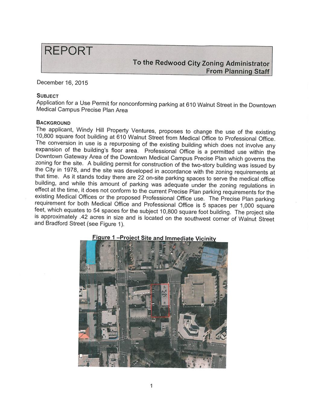
8 E. BRADFORD STREET 2 A 13 S 18'-0" 9'-0" 48'-1" AREA OF WORK WALNUT STREET 24'-0" 24'-0" 9'-0" TRASH ENCLOSURE 7 S 18'-0" SITE PLAN SCALE: 1"=20' An Existing Site Plan for: 610 WALNUT STREET Redwood City, Ca. DATE PROJECT NO: SITE
9 Memorandum Date: October 30, 2015 To: From: Subject: Lisa Ring, LOR Planning & Environmental Consulting Gary Black, Kai-Ling Kuo Trip Generation and Parking Demand Analysis for 610 Walnut Street Office Building in Redwood City This memorandum presents the results of the trip generation and parking demand analysis conducted for the office building located at 610 Walnut Street on the southwest corner of Walnut Street and Bradford Street in Redwood City, California. The 18,258 square-foot project site includes a 10,800 square-foot two-story building. The building was formerly used as medical office space to support the Kaiser Permanente Hospital. The project proposes to retenant the existing building as general/professional office space and to restripe the existing parking lot to provide 22 parking spaces. The project site plan is shown on Figure 1. The purpose of the study is to compare the trip generation and parking demand of office space versus medical office space and demonstrate that the proposed office uses would not generate new vehicle trips or parking demand. Trip Generation Estimates Site traffic generated by the proposed professional office and existing medical office uses was estimated using the vehicle trip generation rates published in the Institute Transportation Engineers (ITE) Trip Generation Manual, 9th Edition, for a general office building (Land Use 710) and a medical-dental office building (Land Use 720). As shown on Table 1, the proposed professional office use would generate 119 daily trips, with 17 trips during the AM peak hour and 16 trips during the PM peak hour, which are fewer than the trips generated by the medical office use. By switching to office space, the project would reduce the site generated traffic by 271 daily trips, including 9 AM peak-hour trips and 23 PM peak-hour trips. Table 1 Project Trip Generation AM Peak Hour PM Peak Hour Daily Daily Pk-Hr Pk-Hr Land Use Size Units Rate Trips Rate In Out Total Rate In Out Total Proposed Use General Office ksf Existing Use Medical Office ksf Net New Trips Generated Notes: All trip rates are from Institute of Transportation Engineers, Trip Generation, 9th Edition, General Office Building (Land Use 710), average rates, expressed in trips per 1,000 square feet (ksf), are used. 2 Medical-Dental Office Building (Land Use 720), average rates, expressed in trips per ksf, are used.
10
11 610 Walnut Street Trip Generation and Parking Demand October 30, 2015 Parking Demand Estimates Parking demand for the proposed professional office and existing medical office uses was estimated using the 85th percentile parking generation rates published in the Institute Transportation Engineers (ITE) Parking Generation Manual, 4th Edition, for a general office building (Land Use 701) and a medical-dental office building (Land Use 720). As shown on Table 2, the maximum parking demand for the proposed professional office use would be 37 vehicles, which are fewer than the parking demand for the medical office use. By switching to office space, the project would reduce the parking demand by 9 vehicles. The site was constructed with 22 surface parking spaces at a parking ratio of 2 spaces per 1,000 square feet, which was in conformance with the planning and zoning codes in effect at the time. The project would provide the same amount of on-site parking spaces. As shown on Table 2, the on-site parking spaces would not be sufficient for the proposed professional office use although the site was constructed in conformance with the planning and zoning codes. Street parking is available on the surrounding streets; however, these parking spaces are metered between 10 am to 6 pm, which are expected to mostly be used for short-term parking by visitors and would not be practical for office employees. The project will implement a transportation demand management (TDM) plan, which will include measures to reduce employee vehicle commute trips and parking demand. Table 2 Project Parking Demand Weekday Peak Period 85th Percentile Parking Demand Land Use Size Units Rate Vehicles Proposed Use General Office ksf Existing Use Medical Office ksf Increase in Parking Demand -9 Notes: All parking rates are from Institute of Transportation Engineers, Parking Generation, 4th Edition, General Office Building (Land Use 701), average rates, expressed in vehicles per 1,000 sq. ft. (ksf), are used. 2 Medical-Dental Office Building (Land Use 720), average rates, expressed in vehicles per ksf, are used. Page 3
12 610 Walnut Street Office Building Transportation Demand Management (TDM) Plan Prepared for: Windy Hill Property Ventures November 30, 2015 Hexagon Transportation Consultants, Inc. Hexagon Office: 4 North Second Street, Suite 400, San Jose, CA Hexagon Job Number: 15KK04 Phone: Document Name: 610 Walnut TDM Plan_ doc
13 610 Walnut Street Office Building TDM Plan November 30, 2015 Table of Contents 1. Introduction Existing Transportation Facilities and Services TDM Measures TDM Implementation and Monitoring List of Figure Figure 1 Project Location... 3 Figure 2 Proposed Site Plan... 4 Figure 3 Existing Transit Services... 8 Figure 4 Existing Bicycle Facilities... 9 Page i
14 610 Walnut Street Office Building TDM Plan November 30, Introduction Transportation Demand Management (TDM) is a combination of services, incentives, facilities, and actions that reduce single-occupant vehicle (SOV) trips to help relieve traffic congestion, parking demand, and air pollution problems. The purpose of TDM is to (1) reduce the amount of traffic generated by new developments; (2) promote more efficient utilization of existing transportation facilities and ensure that new developments are designed to maximize the potential for alternative transportation usage; (3) reduce the parking demand generated by new developments and allow for a reduction in parking supply; and (4) establish an ongoing monitoring and enforcement program to guarantee the desired trip and parking reductions are achieved. In accordance with City goals to reduce the number of vehicle trips into and out of downtown during peak commute hours, as well as the number of vehicles requiring long-term parking in downtown, the propsoed TDM plan for the 610 Walnut Street Office Building (project) seeks to reduce peak-hour commute trips and vehicle parking demand through a combination of appropriate measures to promote alternative forms of transportation. At the request of the Zoning Administrator, monitoring reports will be provided regarding the utilization and efficacy of the TDM plan. Project Description The project site is located at 610 Walnut Street on the southwest corner of Walnut Street and Bradford Street in downtown Redwood City. The 18,258 square-foot project site includes a 10,800 square-foot two-story building. The building was formerly used as medical office space to support the Kaiser Permanente Hospital. The project proposes to retenant the existing building as general/professional office space and to restripe the existing parking lot to provide 22 parking spaces. The parking lot would be served by two driveways, one each on Walnut Street and Bradford Street. Figure 1 shows the location of the project and Figure 2 shows the proposed site plan. The project is located in downtown Redwood City and close to the Redwood City Transit Center for Caltrain and San Mateo County Transit District (SamTrans) transit services. Existing transportation facilities in the project vicinity are described in Chapter 2. The project location by itself provides the following advantages in promoting transit, bicycling, and walking and reducing SOV trips generated by the project. Downtown Location. The location of a project within or adjacent to a central business district promotes pedestrian and bicycle travel in a relatively high density area of complementary land uses. The project is located on the edge of the downtown district, and it is a short walk or bicycle ride from the retail, office, and residential land uses in downtown and the surrounding area. The project location effectively renders it part of a large-scale mixed-use development in a pedestrian-friendly environment with a significant share of internal trips. Page 1
15 610 Walnut Street Office Building TDM Plan November 30, 2015 Proximity to Transit. The project is located at about 0.6 mile, or about a 12-minute walk, from the Redwood City Transit Center that provides Caltrain commuter rail and SamTrans bus services. It is also located within 700 feet of SamTrans bus stops. Caltrain and SamTrans provide frequent and reliable transit service to a high percentage of regional destinations. This project clearly could benefit from the nearby rail and bus services. Page 2
16
17
18 610 Walnut Street Office Building TDM Plan November 30, Existing Transportation Facilities and Services Transportation facilities and services that support sustainable modes of transportation include commuter rail, buses and shuttle buses, bicycle facilities, and pedestrian facilities. This chapter describes existing facilities and services near the project site that will support the TDM measures contained in this plan. Transit Services Existing transit services in the project vicinity are provided by Caltrain and SamTrans are described below. The Caltrain Station and local SamTrans bus routes near the project site are shown on Figure 3. Caltrain Commuter Rail Caltrain provides commuter rail service between San Francisco and San Jose, with limited service to Gilroy during commute hours. The Redwood City Caltrain Station is located about 0.6 miles southwest of the project site at the Redwood City Transit Center. The station has bike racks, bike lockers, and three parking lots. Additional amenities at the station include bikes from the Bay Area Bike Share Program and cars from the car share program, Zipcar. The Redwood City Station is served by local-stop, limited-stop, and baby bullet trains. During the morning peak period of 6:00-9:30 AM, the Redwood City Station is served by ten northbound trains, including three baby bullet and seven limited-stop trains, with headways between 6 and 39 minutes. Eleven southbound trains, including one local-stop, three baby bullet, and seven limited-stop trains, serve the Redwood City Station in the AM peak period with headways between 6 and 44 minutes. During the PM peak period between 3:30-7:30 PM, the station is served by twelve northbound trains, including three baby bullet, seven limitedstop, and two local-stop trains with headways between 6 and 39 minutes. Eleven southbound trains, including one local stop, three baby bullet, seven limited-stop trains, with headways between 6 and 49 minutes serve the Redwood City Station during PM peak hours. As part of the Caltrain Modernization Program, the rail service will be electrified. With the electrification of service, Caltrain will be able to provide faster and more frequent service along the corridor, including the Redwood City Station. SamTrans Bus SamTrans primarily serves as a local bus provider within San Mateo County, but also provides local and regional bus services to neighboring Santa Clara and San Francisco Counties. The existing SamTrans bus routes that operate during peak commute hours on weekdays and have bus stops within 0.5 mile of the project site are described below and shown on Figure 4. Page 5
19 610 Walnut Street Office Building TDM Plan November 30, 2015 Route 270. Route 270 loops Redwood City Transit Center, downtown Redwood City, and Atherton with 60 minute headways. The closest stop is at Jefferson Avenue/Marshall Street about 1,100 feet southwest of the project site. Route 276. Route 276 provides stops at the Redwood City Transit Center, downtown Redwood City, and Atherton with 60 minute headways. The closest stop is at Main Street/Marshall Street about 700 feet southwest of the project site. Route 296. Route 296 travels between the Redwood City Transit Center, the Menlo Park Caltrain Station, and East Palo Alto with 30 minute headways during the AM commute hours and 15 minute headways during the PM commute hours. The closest stop is at Cassia Street/Middlefield Road about 0.42 mile south of the project site. Route FLX San Carlos. Route FLX San Carlos is a one-year pilot weekday bus route that mixes fixed and flexible routing for customer convenience, with service between the Redwood City Transit Center and the San Carlos Caltrain Station. During the AM and PM commute hours, Route FLX San Carlos has a fixed schedule with 50 minute headways. The closest stop is at Winslow Street/Brewster Avenue about 0.47 mile northwest of the project site. Bicycle Facilities The bicycle facilities that exist within one mile of the project site include striped bike lanes (Class II bikeway), and shared bike routes (Class III bikeway). The existing bicycle facilities are shown graphically on Figure 4. Bike routes are existing right-of-ways that accommodate bicycles but are not separate from the existing travel lanes. Bike routes are typically designated only with signs. Bike lanes provide a striped lane for one-way bike travel on a street or highway and are designed for the exclusive use of cyclists with certain exceptions. For instance, right turning vehicles must merge into the lane before turning. Existing bike lanes are present along the following street segments: Walnut Street between Veterans Boulevard and Bradford Street Veterans Boulevard between Whipple Avenue and Chestnut Street Main Street between Convention Way and Veterans Boulevard Marshall Street between Arguello Street and Main Street Middlefield Road between Cassia Street and Woodside Road Winslow Street between Broadway and Howland Street Brewster Avenue between Arguello Street and Main Street Broadway between Chestnut Street and Woodside Road Maple Street between Main Street and El Camino Real Arguello Street between Whipple Avenue and Brewster Avenue Bike routes are existing rights-of-way that accommodate bicycles but are not separate from the existing vehicle travel lanes. Bike routes are typically designated only with signs or shared use arrows marking on the pavement, known as sharrows. Sharrows are most often used on roadways that are too narrow to install a standard striped bike lane. Bike routes are present along the following street segments: Middlefield Road between Winslow Street and Main Street Winslow Street between Broadway and Middlefield Road Arguello Street between Broadway and Brewster Street There are no bicycle facilities on Bradford Street in the immediate vicinity of the site. However, because of low traffic volumes on Bradford Street, it is conducive to bicycling. The Redwood City Downtown Precise Plan shows bicycle facilities are proposed on several additional downtown roadways within the project vicinity. The City participates in the Bay Area Bike Share Program, which allows users to rent and return bicycles at several locations in the downtown area, including the Redwood City Transit Center, San Mateo County Page 6
20 610 Walnut Street Office Building TDM Plan November 30, 2015 Center, Redwood City Public Library, and Kaiser Hospital. The closest station is at Kaiser Hospital at the intersection of Walnut Street and Veterans Boulevard. Pedestrian Facilities Sidewalks are present throughout the Redwood City downtown area and the nearby residential neighborhoods. Crosswalks are provided at all intersections in the downtown core and pedestrian walk signals are provided at many signalized intersections. The area is viewed as a pedestrian-friendly environment. In the immediate vicinity of the project site, the intersection of Walnut Street and Bradford Street is an all-way stop-controlled intersection with crosswalks provided across the west and south legs. The intersection of Main Street and Bradford Street is a two-way stop-controlled intersection with crosswalks provided across all legs. The intersection of Walnut Street and Marshall Street is a two-way stop-controlled intersection with crosswalks provided across all legs. The signalized intersection of Main Street and Marshall Street has pedestrian signal heads and crosswalks across the north, south, and west legs. Page 7
21
22
23 610 Walnut Street Office Building TDM Plan November 30, TDM Measures This chapter describes TDM measures that are applicable to the proposed office use. The TDM measures to be implemented by the project s future tenants include planning and design measures that will encourage walking, biking, and use of transit. The TDM measures were developed to reduce employees peak-hour commute trips and vehicle parking demand. Employee Transportation Coordinator The property manager will work with future employers to designate an employee transportation coordinator (ETC) who will be responsible for implementing and managing the TDM plan. This ETC will be a point of contact for employees should TDM-related questions arise, and will be responsible for ensuring that employees are aware of all transportation options and how to fully utilize the TDM programs. The ETC will provide the following services and functions to ensure the TDM plan runs smoothly: Provide information about monthly transit passes Provide transportation information packets to new employees Distribute transportation news and commuter alerts Assist with rideshare matching Implement Guaranteed Ride Home Service Manage travel surveys to track trends and develop new commute programs Alternative Transportation Information and TDM Marketing The property manager will work with future employers to provide information on non-auto transportation alternatives and TDM programs through the ETC. New employers/employees will be provided transportation information packets. This packet will include information about transit maps/schedules (Caltrain and SamTrans), locations of bus stops, bike maps, guaranteed ride home service, ride matching services, transit planning resources, and bicycle parking on-site. Also included in the packet will be information regarding how to contact the ETC assigned to the development. The ETC will set up and maintain an on-line transportation kiosk with information on non-auto transportation alternatives. Telecommute/Flexible Work Schedule Program Offering employees the opportunity to work from home or travel outside the peak travel periods can help reduce the number of commute trips to and from the project site. The project will include the following infrastructure to support its future tenants to implement an alternative work schedule: Heating, cooling, and ventilation systems will be available for extended schedules. Page 10
24 610 Walnut Street Office Building TDM Plan November 30, 2015 High-bandwidth internet connections will be included to facilitate telecommuting Security services will be provided to support extended schedules. Guaranteed Ride Home Program Guaranteed Ride Home (GRH) is a program that provides a back-up ride to employees who use transit, carpool, biking/walking, or other alternative as their commute mode. It is an important supportive measure to encourage employees to not drive alone to work. The property manager will work with future tenants to provide the GRH service to future employees. The program will be managed by the ETC. The GRH program is typically implemented through contracting with a ride service, such as a taxi company, or transportation network companies (TNC), such as Uber. Transit Programs Trip Planning Resources Online transit trip planning services are available to the greater San Francisco Bay Area through 511.org. Users enter their starting and ending points, and either the desired starting or ending trip time. The service can build an itinerary that best suits the user s preferences for the fastest trip, fewest transfers, or least walking. Many popular features from 511.org can be accessed using smart phones or mobile devices. With 511 Mobile, commuters can: (1) receive real-time transit departure predictions, (2) plan a public transit trip, (3) check real-time traffic conditions on the live traffic map, and (4) get current driving times for the most popular routes in the Bay Area. Dadnab.com enables Bay Area commuters to get transit directions by text message. Users send a text message with their origin, destination, and optional departure or arrival time and Dadnab replies with a detailed itinerary listing which buses or trains to take, stop locations, and departure times. Pre-tax Commuter Benefits Pre-tax commuter benefit programs allow employees to pay for transit passes with pre-tax earnings and can help encourage transit use among employees. These benefits are offered at the federal tax level and are available to employers of any size. One example is the Commuter Checks program. Subsidized or Free Transit Passes Future tenants may wish to provide free or subsidized transit passes (Caltrain or SamTrans) for their employees. There are a number of ways to structure a financial incentive for transit. Employers can cover a portion or the total monthly cost of transit for those employees who take transit through a pre-tax benefit, or purchase transit passes themselves and distribute them to employees, or offer a universal transit pass program. Employers may consider universal transit pass programs, which are different from financial incentives in that an employer purchases a pass for all employees, regardless of whether they currently ride transit or not. These passes typically provide unlimited transit rides on local or regional transit providers for a low monthly fee; a fee that is lower than the individual cost to purchase a pass as a bulk discount is given. Such programs are a more cost effective option for employers with regards to reducing vehicle trips as compared to purchasing individual passes. Caltrain Go Pass It is expected that the majority of the employees taking public transit will take Caltrain to work; therefore future tenants should consider the Caltrain universal transit pass program (Go Pass program). The Caltrain Go Pass is an annual pass purchased by a company for its employees. All eligible employees receive the Go Pass, whether they use it or not. The passes are purchased from Caltrain at a significant discount and provide all employees with free Caltrain travel between all zones, seven days a week. The passes are non-transferable Page 11
25 610 Walnut Street Office Building TDM Plan November 30, 2015 stickers applied directly to the Employee ID card to prevent cheating, which can otherwise be a problem with transit subsidies. For 2016, the total cost of participating in the Go Pass program costs is the greater of $190 per user or $15,960 per company per year. To determine the cost, multiply the number of eligible users by $190. If the total is less than $15,960, the participation cost is $15,960. If the total exceeds $15,960, the cost is $190 per eligible user. The cost of monthly pass for individuals ranges from $73 to $338, depending on travel distance. Assuming a monthly pass cost of $179 (3 travel zones) for each employee, if a company has more than 7 employees regularly taking Caltains, it will be more cost effective for the company to participate in the Go Pass program ($179 per month x 12 months x 8 employees = $17,184 per year). SamTrans Way2Go Program Similar to the Caltrans Go Pass program, the SamTrans Way2Go program allows companies to purchase annual ride passes for all eligible employees. Participants pay an annual fee for every eligible employee who will use the program. Currently, the total cost of participating in the Way2Go Pass program is the greater of $125 per eligible employee or $12,500 per company per year. Based on a monthly pass cost of $64 for each employee, it will cost $765 per year for an employee regularly taking SamTrans. Carpool and Vanpool Programs Rideshare Matching Services Existing programs such as 511.org can be utilized to facilitate carpooling. The 511 Carpool Calculator is a 511-sponsored online calculator that determines the cost of commuting by driving alone as well as the potential savings by adding carpool partners. The 511 RideMatch service provides an interactive, on-demand system that helps commuters find carpools, vanpools or bicycle partners. This free carpool and vanpool ridematching service helps commuters find others with similar routes and travel patterns with whom they may share a ride. Ride matching assistance is also available through a number of peer-to-peer matching programs, such as Zimride, which utilize social networks to match commuters. There are also many free and commercial applications offering carpooling or discounted taxi services. These applications are created by third-party app developers for smart phone users. Carpooling applications include Carma and SliceRides. Discounted taxi services include Uber, Lyft, and Sidecar Ride. Subsidized or Free Vanpools or Carpools Future tenants may wish to provide their employees with financial incentives to utilize carpooling or vanpooling when commuting to and from the project site. If employers/employees are interested in establishing a vanpool there are several existing services that can assist employers. 511.org can provide assistance in setting this program up and finding a vendor. One example of an existing vendor in the Bay Area is Enterprise, which offers vanpooling services for both individuals and employers. Bicycle Programs Bicycle Storage/Facility Based on the Redwood City Downtown Precise Plan, the project is required to provide 11 bicycle parking spaces. The project will provide one unisex shower room on the ground floor and install 2 bicycle racks (4 spaces) near the building entryway on the Walnut Street for short-term bicycle parking. Additionally, as part of the lease agreements, future tenants will be allowed to bring their bikes into the building and store the bicycles at their cubes/office area. The project will meet the total11-space requirement by allowing employees to bring bikes into their cubes/office area. Page 12
26 610 Walnut Street Office Building TDM Plan November 30, 2015 Biking Financial Incentives Future tenants may consider providing their employees with financial incentives to utilize biking when commuting to and from the project site. Offering financial incentives can have a measurable impact on encouraging employees to try modes other than driving alone to work. Daily, weekly, or monthly financial incentives could be offered to those employees who use a bike as their primary mode of travel to work. One example of a biking financial incentive is the Federal Bike Commuter Benefit which lets bike commuters receive up to $20 per month as a tax-free employer subsidy for riding to work. This benefit cannot be used in combination with the pre-tax transit benefit in the same month. Additional financial incentives beyond what can be taken tax-free may be appropriate to further encourage biking as a commute mode. Car Sharing Program One of the major impediments to using transit, bicycling, carpooling, or vanpooling to get to work is employees need to use a car occasionally to make a mid-day trip for personal or business purposes. Car sharing programs, such as Zipcar, provide individuals with access to a vehicle when they need it during the work day, so they do not need to drive their own car. The Zipcar program can also function as an additional option for the GRH program (i.e., depending on where an employee lives, using a Zipcar may make more sense than taking a taxi home). Future tenants may wish to register for Zipcar. Zipcar currently has cars available at the Redwood City Transit Center, which is about 0.6 miles away from the project site. As Zipcar becomes more popular, other, closer, parking spaces may become available. Bay Area Bike Share Program The Bay Area Bike Share Program is a network of unique commuter-style bikes that can be checked out from and returned to self-service bike share stations for short trips. The idea behind bike sharing is to make bikes available to transit users for the short journey between a transit station and the workplace. They also are available to transit users and carpoolers in the same way as car sharing vehicles for making a business or personal trip during the day. Future tenants may wish to provide their employees with financial incentives for signing up for and using the Bay Area Bike Share program. The program has several locations in the downtown area, including the Redwood City Transit Center, San Mateo County Center, Redwood City Public Library, and Kaiser Hospital. The closest station is at Kaiser Hospital at the intersection of Walnut Street and Veterans Boulevard, which is approximately 600 feet from the project site. The stations at the San Mateo County Center and Redwood City Public Library are about 0.3 and 0.4 mile, respectively, from the project site. The Redwood City Transit Center station is about 0.6 mile from the project site. Page 13
27 610 Walnut Street Office Building TDM Plan November 30, TDM Implementation and Monitoring The purpose of the TDM plan is to reduce employees peak-hour commute trips and vehicle parking demand. In accordance with the intent of the Kaiser Medical Center Precise Plan, Chapter III, Circulation Policy E (Transportation Demand Management Plan), and similar to the Redwood City Zoning Ordinance, Article 26 (Central Business Retail District), Section 26.10, the Zoning Administrator may request reports regarding the utilization of the TDM plan every six months if there is indication that the plan is inadequate per the Zoning Administrator s determination. The plan will be evaluated at the six-month point, the one-year point, and then at the request of the Zoning Administrator to assess the actual mode shift achieved at the site and to identify any adjustments to the program necessary to ensure that the TDM measures are successful. Implementation The property manager will submit this TDM plan to the city and be responsible for ensuring that the TDM trip reduction measures are implemented. After the development is constructed and office space is rented, the property manager will identify an ETC for implementing maintaining the elements of the TDM plan. If the ETC changes for any reason, the City and tenants will be notified of the name and phone number of the new designated ETC. In addition, all lease agreements will require tenants to participate in the TDM plan immediately upon occupancy. Lease agreements will describe the elements of this plan for which tenants have immediate or potential future responsibility. Monitoring The TDM plan will be evaluated annually to assess the trip reduction in employees peak-hour commute trips, the peak parking demand, and to identify any adjustments to the programs necessary to ensure that the parking supply is sufficient for the project. The annual monitoring will be administered by the designated ETC. It is recommended that the designated ETC consults with City staff to ensure the monitoring and reporting meets the City s expectations. The plan will be monitored based on City s requirements, which typically include the following: Annual vehicle trip and parking counts. o Counts will be conducted by a third party. o Vehicle counts will be conducted once between 7:00-9:00 AM and once between 4:00-6:00 PM on a typical weekday (Tuesday, Wednesday, or Thursday) when school is in session. o Parking counts will be taken every hour between 7:00 AM 6:00 pm on a typical weekday. o Counts will be taken at the entry point to the parking lot. Page 14
28 610 Walnut Street Office Building TDM Plan November 30, 2015 Annual employee mode share survey. The survey will provide qualitative data regarding employee perceptions of the alternative transportation programs and perceptions of the obstacles to using an alternative mode. Based on the results of vehicle trip and parking counts and employee mode share survey, peak-hour vehicle trips generated by the project s employees will be compared to the number of peak-hour trips estimated with the Institute of Traffic Engineers rates. The employee survey results will measure the relative effectiveness of individual program components and facilitate the design of possible program enhancements. Annual Reports The property manager will submit reports to the Redwood City for three years and then upon request of the Zoning Administrator for the life of the project with the following information: Findings of the vehicle trip counts and employee mode share survey, including reduction in peak hour vehicle trips and peak parking demand. Effectiveness of individual program components from the annual employee mode share survey. A description of the TDM programs and services that are currently offered to employees/tenants. Page 15
![CITY OF REDWOOD CITY CONDITIONS OF APPROVAL 610 Walnut Street UP2015-022 Use Permit The following Conditions of Approval [COA] and Standard Development Requirements [SDR] apply to this project.](/docs-images/76/74265188/images/29-0.jpg "The COAs are specific conditions applicable to the proposed project.")
29 CITY OF REDWOOD CITY CONDITIONS OF APPROVAL 610 Walnut Street UP Use Permit The following Conditions of Approval [COA] and Standard Development Requirements [SDR] apply to this project. The COAs are specific conditions applicable to the proposed project. The SDRs are items which are codified or adopted by resolution and have been included for ease of reference, they may not be appealed or changed. The SDRs are not intended as a comprehensive list. The COAs and SDRs are grouped under specific headings that relate to the subject matter. In addition to complying with all applicable City, County, State and Federal Statutes, Codes, Ordinances, Resolutions and Regulations, Permittee expressly accepts and agrees to comply with the following Conditions of Approval and Standard Development Requirements of this Permit: Transportation Requirements 1. Final TDM Program - Prior to issuing a certificate for building occupancy, the applicant shall provide a final transportation demand management (TDM) program (acceptable to the City Engineer) which outlines the program elements to be implemented by property management and by the tenant(s). The program shall include an annual reporting requirement detailing parking utilization rates, TDM program use, and employee mode choice, due on December 1 st of each year. The reporting requirement will continue until the project s parking lot reaches an average weekday occupancy of 95% and thereafter for three years. Whenever the project s average weekday parking occupancy reaches or exceeds 95%, the property owner will have 3 months to revise and resubmit their TDM program to the City, outlining how the program will further incentivize a reduction in vehicle trips to the site. [COA] [TRANSPORTATION] 2. Overflow Parking Once parking lot occupancy reaches 95%, the Applicant shall (within 5 business days) provide the City with the location of overflow parking and provide written evidence that it has obtained rights to use such overflow parking. Applicant shall maintain rights to use such overflow parking until a revised TDM program is implemented and monitored to show that parking lot occupancy is again below 95%. If the applicant does not provide the required overflow parking and/or the revised TDM program does not adequately reduce parking demand below 95% of parking lot occupancy, the City shall have the option of requiring payment of Downtown Parking Zone in-lieu parking fees for all required parking spaces not provided on the site, or revoking the Use Permit pursuant to Condition of Approval No. 8 below. [COA] [TRANSPORTATION]
30 3. Tenant Participation in TDM Program - All tenant leases shall require participation in the Transportation Demand Management (TDM) program immediately upon occupancy, including the designation of an employee transportation coordinator for each employer. [COA] [TRANSPORTATION] 4. Construction Use of Right-of-Way - No construction parking, material storage, equipment, or other construction-related use shall be allowed within the City right-ofway without prior approval from the City Engineer. Prior to encroachment permit issuance, the applicant shall submit a construction parking management plan, which shall outline the number of construction workers by phase, phase duration, and where workers will park for each phase of work. [COA] [TRANSPORTATION] 5. Removal of Parking Meters - Prior to removing any public parking spaces from public use during construction, the applicant shall apply for a Temporary Parking Meter Permit per Municipal Code sections through Temporary Parking Meter Permits require an application fee and payment for any displaced parking spaces. [COA] [TRANSPORTATION] 6. Removal or Blockage of On-Site Parking None of the on-site parking spaces may be blocked or removed from use, either temporarily or permanently. [COA] [TRANSPORTATION] General Requirements 7. Compliance with Codes - The applicant shall comply with all applicable local, state, and federal rules and regulations at all times, which includes applicable Fire and Building and Zoning codes. [COA][PLANNING] 8. Compliance with Conditions of Approval Non-compliance with the conditions of approval may result in the revocation of the Use Permit or require payment of in-lieu fees for the parking not provided on-site. [COA] [PLANNING] 9. Substantial Conformity - Applicant shall ensure that the parking lot improvements substantially conform to the site plan stamped received on October 28, 2015, and related information submitted by the Applicant, on file with Planning Services. [COA][PLANNING] 10. Review of Modifications - All modifications to the approved plans/use shall be submitted to Planning for review and approval prior to the issuance of a Building Permit or operation. Substantial modification of approved plans, as determined by the Zoning Administrator, may be subject to an amendment or a new Permit. [COA][PLANNING] 11. Signs No signage is approved as part of this application and any future signs will require a separate sign permit. If the building has multiple tenants, a Sign Program shall be required. [COA] [PLANNING]
31 12. Indemnification Per Redwood City Code Section 1.54, Applicant shall defend (with counsel approved by City), indemnify, and hold harmless the City, its agents, officers, and employees from and against any claim, action, or proceeding against the City or its agents, officers or employees, to attack, set aside, void, or annul an approval of the Project, including without limitation any related application, permit, certification, condition, environmental determination, other approval, compliance or failure to comply with applicable laws and regulations, and/or processing methods (each such claim, action, or proceeding, a Challenge ). If Applicant does not promptly defend any Challenge, City may (but is not obligated to) defend such Challenge as City, in its sole discretion, determines appropriate, all at applicant s sole cost and expense. Applicant shall bear any and all losses, damages, injuries, liabilities, costs, and expenses (including, without limitation, staff time and in-house attorney's fees on a fully-loaded basis, attorney s fees for outside legal counsel, expert witness fees, court costs, and other litigation expenses) arising out of or related to any Challenge ( Costs ), whether incurred by Developer, City, or awarded to any third party, and shall pay to the City upon demand any Costs incurred by the City. No modification of the project, any application, permit, certification, condition, environmental determination, other approval, change in applicable laws and regulations, or change in processing methods shall alter the applicant s indemnity obligation. Per California Government Code Section , Applicant s indemnification obligation with respect to any claim, action or proceeding to attack, set aside, void, or annul an approval of City concerning a subdivision (tentative, parcel, or final map application or approval) shall be limited to actions brought within the time period provided for in California Government Code Section , unless such time period is extended for any reason. The City shall promptly notify Applicant of any such claim, action or proceeding and shall cooperate fully in the defense. [COA][OFFICE OF THE CITY ATTORNEY]
Millbrae Serra Station Development Millbrae, California
 Millbrae Serra Station Development Millbrae, California Transportation Demand Management Plan Prepared for: Mr. Vincent A. Muzzi, Millbrae Serra Station, LLC June 15, 2016 Hexagon Transportation Consultants,
Magnolia Place. Traffic Impact Analysis. Prepared for: City of San Mateo. Prepared by: Hexagon Transportation Consultants, Inc.
 Magnolia Place Traffic Impact Analysis Prepared for: City of San Mateo Prepared by: Hexagon Transportation Consultants, Inc. Updated January 4, 2010 Table of Contents 1. Introduction...1 2. Existing Conditions...6
June 3, Attention: David Hogan City of San Mateo 330 W. 2oth Avenue San Mateo, CA 94403
 June 3, 2015 Attention: David Hogan City of San Mateo 330 W. 2oth Avenue San Mateo, CA 94403 Regarding: PA # 15-030, Bridgepointe Shopping Center 2202 Bridgepointe Parkway, APN 035-466-10 Dear David: Enclosed
 MEMORANDUM - CITY OF PASADENA Department Of Transportation DATE: OCTOBER 21, 2008 TO: ENVIRONMENTAL ADVISORY COMMISSION FROM: ~ FRED C. DOCK, DIRECTOR OF TRANSPORTATION SUBJECT: UPDATE ON DEPT. OF TRANSPORTATION
SAN FRANCISCO MUNICIPAL TRANSPORTATION AGENCY
 THIS PRINT COVERS CALENDAR ITEM NO. : 11 DIVISION: Sustainable Streets BRIEF DESCRIPTION: SAN FRANCISCO MUNICIPAL TRANSPORTATION AGENCY Approving traffic modifications on Twin Peaks Boulevard between Christmas
REDWOOD CITY STREETCAR - ALTERNATIVES ANALYSIS
 REDWOOD CITY STREETCAR - ALTERNATIVES ANALYSIS The purpose of this document is to ennumerate the analysis of alternatives for a streetcar along the Broadway Corriodor of Redwood City. The six alternatives
AGENDA ITEM G-2 Public Works
 AGENDA ITEM G-2 Public Works STAFF REPORT City Council Meeting Date: 12/6/2016 Staff Report Number: 16-214-CC Regular Business: Approve the Oak Grove University Crane Bike Improvement Concept Plan, authorize
San Mateo County Comprehensive Bicycle and Pedestrian Plan Open House
 San Mateo County Comprehensive Bicycle and Pedestrian Plan Open House October 28, 2010 Presented to San Mateo County residents and interested parties by Lauren Ledbetter, Alta Planning + Design Matt Haynes,
Sebastopol Charter School Traffic Management Plan
 Sebastopol Charter School The serves as the working document in support of these essential goals: to ensure the safety and efficiency of student arrival to and departure from school to ensure the safety
Key objectives of the survey were to gain a better understanding of:
 3 COMMUNITY INPUT Community input is an essential part of corridor studies. For the SR 87 corridor study, VTA staff conducted an extensive online survey of people living and commuting along the corridor.
Caltrain Bicycle Parking Management Plan DRAFT PROJECT SCOPE SUBMITTED TO CALTRANS FALL 2014
 Caltrain Bicycle Parking Management Plan DRAFT PROJECT SCOPE SUBMITTED TO CALTRANS FALL 2014 NOTE: The following draft scope of work was developed by Caltrain in the fall of 2014 as part of a Caltrans
SETTINGS AND OPPORTUNITIES MOBILITY & ACCESS
 7 mobility & access how do people use el camino what is it like to drive on el camino/to park along el camino what is the pedestrian experience like what is the role of transit along the corridor what
Traffic Impact Memorandum. May 22, 2018
 BISHOP PROFESSIONAL DEVELOPMENT BUILDING Proposed Land-use Change & Parking Modification 3601 SW 31st Street Topeka, Kansas 66614 CFS Project No. 185077 Traffic Impact Memorandum May 22, 2018 Prepared
Roads and Vehicular Traffic Design Principles. Roads and Vehicular Traffic Recommendations
 CIRCULATION AND PARKING roads and vehicular traffic The Campus Master Plan updates the campus transportation network through a multi-modal approach that encourages walking and biking while improving vehicular
Sustainable Transportation Plan Draft 4/24/2012
 Sustainable Transportation Plan 2011-2012 Draft 4/24/2012 Contents I. Purpose... 3 II. Background... 3 III. Recent Accomplishments... 6 IV. Anticipated Changes... 8 V. Planning Process... 8 VI. Priorities...
WELCOME. City of Greater Sudbury. Transportation Demand Management Plan
 WELCOME City of Greater Sudbury Transportation Demand Management Plan Public Consultation Session St. Andrew s Place, Activity Hall 111 Larch Street Wednesday September 13, 2017 6:00 to 8:00 pm Welcome
SAN FRANCISCO MUNICIPAL TRANSPORTATION AGENCY BOARD OF DIRECTORS. RESOLUTION No
 SAN FRANCISCO MUNICIPAL TRANSPORTATION AGENCY BOARD OF DIRECTORS RESOLUTION No. 15-031 WHEREAS, Transportation Code Division II, Section 909 authorizes the Director of Transportation to install and permit
FROM: CITY MANAGER DEPARTMENT: PLANNING AND COMMUNITY ENVIRONMENT DATE: OCTOBER 4, 2004 CMR:432:04
 TO: HONORABLE CITY COUNCIL FROM: CITY MANAGER DEPARTMENT: PLANNING AND COMMUNITY ENVIRONMENT DATE: OCTOBER 4, 2004 CMR:432:04 SUBJECT: FINANCE COMMITTEE RECOMMENDATION TO ADOPT TRANSPORTATION STRATEGIC
Transportation, Parking & Roads
 Transportation, Parking & Roads Design Carolina North as a walkable community Design the transportation system and development patterns (i.e., urban design elements such as density, building design, mix
ATTACHMENT 4 - TDM Checklist. TDM Checklist Overview
 ATTACHMENT 4 - TDM Checklist TDM Checklist Overview The proposed checklist rates developments on the degree to which they are TDM and transit supportive. Points are assigned based on the level of transit
SAN FRANCISCO MUNICIPAL TRANSPORTATION AGENCY
 THIS PRINT COVERS CALENDAR ITEM NO.: 10.3 DIVISION: Sustainable Streets BRIEF DESCRIPTION: SAN FRANCISCO MUNICIPAL TRANSPORTATION AGENCY Approving various traffic and parking modifications on Bay Street
Solana Beach Comprehensive Active Transportation Strategy (CATS)
") Solana Beach Comprehensive Active Transportation Strategy (CATS) 3.0 Goals & Policies The Solana Beach CATS goals and objectives outlined below were largely drawn from the Solana Beach Circulation Element
Solana Beach Comprehensive Active Transportation Strategy (CATS) 3.0 Goals & Policies The Solana Beach CATS goals and objectives outlined below were largely drawn from the Solana Beach Circulation Element
CPC Parking Lot Riverside Drive. Transportation Rationale
 CPC Parking Lot Transportation Rationale Prepared By: NOVATECH Suite 200, 240 Michael Cowpland Drive Ottawa, Ontario K2M 1P6 September 2015 Novatech File: 114093 Ref: R-2015-153 Table of Contents 1.0 INTRODUCTION...
TRANSPORTATION TRAINING TOPICS. April 6, 2010
 TRANSPORTATION TRAINING TOPICS April 6, 2010 Roles of Transportation Providers Context and Policy Makers Division of Transportation and Traffic Other City Operations Other Transportation Operators CMA
REQUIREMENTS FOR TRAFFIC CONTROL PLAN SUBMISSION
 REQUIREMENTS FOR TRAFFIC CONTROL PLAN SUBMISSION A draft traffic control plan, consistent with the following applicable conditions, must be included in every permit application submitted to the City of
Bicycle Master Plan Goals, Strategies, and Policies
 Bicycle Master Plan Goals, Strategies, and Policies Mobilizing 5 This chapter outlines the overarching goals, action statements, and action items Long Beach will take in order to achieve its vision of
Travel Demand Management. Travel Reduction Program Sun Rideshare Tucson On The Move
 Travel Demand Management Travel Reduction Program Sun Rideshare Tucson On The Move Travel Demand Management TDM in Tucson has changed over the last two to three years: Outreach and marketing to all residents,
SAN FRANCISCO MUNICIPAL TRANSPORTATION AGENCY
 THIS PRINT COVERS CALENDAR ITEM NO.: 10.2 DIVISION: Sustainable Streets BRIEF DESCRIPTION: SAN FRANCISCO MUNICIPAL TRANSPORTATION AGENCY Approving various routine parking and traffic modifications. SUMMARY:
EXECUTIVE SUMMARY... vii 1 STUDY OVERVIEW Study Scope Study Area Study Objectives
 Contents EXECUTIVE SUMMARY... vii 1 STUDY OVERVIEW... 1-1 1.1 Study Scope... 1-1 1.2 Study Area... 1-1 1.3 Study Objectives... 1-3 2 EXISTING CONDITIONS... 2-1 2.1 Existing Freeway Conditions... 2-4 2.1.1
Mission Street Medical Office Development
 reet Medical Office Development Traffic Impact Analysis Prepared for: Palo Alto Medical Foundation February 23, 2012 Hexagon Office: 7888 Wren Avenue, Suite B121 Gilroy, CA 95020 Hexagon Job Number: 11RD11
CONNECTING PEOPLE TO PLACES
 CONNECTING PEOPLE TO PLACES 82 EAST BENCH MASTER PLAN 07 Introduction The East Bench transportation system is a collection of slow moving, treelined residential streets and major arteries that are the
Memorandum. Fund Allocation Fund Programming Policy/Legislation Plan/Study Capital Project Oversight/Delivery Budget/Finance Contract/Agreement Other:
 Memorandum Date: November 20, 2017 To: Transportation Authority Board From: Eric Cordoba Deputy Director Capital Projects Subject: 12/5/17 Board Meeting: San Francisco Freeway Corridor Management Study
CHAPTER 3. Transportation and Circulation
 CHAPTER 3 Transportation and Circulation 3.0 TRANSPORTATION AND CIRCULATION This chapter evaluates traffic circulation, transit, parking, pedestrian, bicycle, and rail operational conditions in the Project
Dear City Council Members,
 From: Bob Kenyon [mailto: ] Sent: Monday, February 08, 2016 10:20 AM To: City Clerk Subject: Please prioritize Caltrain and a complete transit network Thank you for prioritizing bringing BART to San Jose
NM-POLICY 1: Improve service levels, participation, and options for non-motorized transportation modes throughout the County.
 Transportation PRINCE WILLIAM COUNTY 2008 COMPREHENSIVE PLAN NON-MOTORIZED PLAN CONTENTS Goals, Policies, and Action Strategies Table 4 (Bike Facility Classifications and Descriptions) Table 5 (Bike Facility
Corpus Christi Metropolitan Transportation Plan Fiscal Year Introduction:
 Introduction: The Safe, Accountable, Flexible, Efficient Transportation Equity Act: A Legacy for Users (SAFETEA-LU) has continued the efforts started through the Intermodal Surface Transportation Efficiency
Purpose and Need. Chapter Introduction. 2.2 Project Purpose and Need Project Purpose Project Need
 Chapter 2 Purpose and Need 2.1 Introduction The El Camino Real Bus Rapid Transit (BRT) Project (Project) would make transit and other transportation improvements along a 17.6-mile segment of the El Camino
Moving Ahead. (Community Engagement) Chapter Three
 Chapter Three") 3 Community Chapter Three Moving Ahead (Community Engagement) engagement provided an exciting opportunity to engage Redwood City residents, workers, and business owners people who walk, bike, take transit,
3 Community Chapter Three Moving Ahead (Community Engagement) engagement provided an exciting opportunity to engage Redwood City residents, workers, and business owners people who walk, bike, take transit,
Bike San Mateo County San Mateo County Bicycle Plan Recommendations August 30, 2010
 Policy and Procedures Develop and Implement a Complete Streets Policy to comply with DD-64-R1 and AB1358 Commencing January 1, 2011, AB1358 requires that the legislative body of a city or county, upon
TRANSPORTATION MASTER PLAN Review Citywide Recommendations, Updated List and Scoring Methodology December 6, 2018
 NOTE: Due to lengthy Committee discussion and allotted meeting time, slides 12-35 were not presented at the meeting, but are provided here for reference. TRANSPORTATION MASTER PLAN Review Citywide Recommendations,
Transportation-Demand Management Community Presentation
 Transportation-Demand Management Community Presentation American University Office of Risk, Safety and Transportation programs Thursday, June 7, 2018 Program Objectives Improve transportation options for
SANTA CLARA COUNTYWIDE BICYCLE PLAN August 2008
 SANTA CLARA COUNTYWIDE BICYCLE PLAN August 2008 To assist VTA and Member Agencies in the planning, development and programming of bicycle improvements in Santa Clara County. Vision Statement To establish,
El Centro Mobility Hub
 The El Centro drive shed comprises a major portion of the El Centro downtown area, which is well served by bus routes. The proposals intend to promote use of public transit through improvements and enhancements
CITY OF COCOA BEACH 2025 COMPREHENSIVE PLAN. Section VIII Mobility Element Goals, Objectives, and Policies
 CITY OF COCOA BEACH 2025 COMPREHENSIVE PLAN Section VIII Mobility Element Goals, Objectives, and Policies Adopted August 6, 2015 by Ordinance No. 1591 VIII MOBILITY ELEMENT Table of Contents Page Number
SAN FRANCISCO MUNICIPAL TRANSPORTATION AGENCY
 THIS PRINT COVERS CALENDAR ITEM NO. : 10.2 DIVISION: Sustainable Streets BRIEF DESCRIPTION: SAN FRANCISCO MUNICIPAL TRANSPORTATION AGENCY Adopting Conceptual Proposal for Streetscape Improvements to Broadway,
Exhibit 1 PLANNING COMMISSION AGENDA ITEM
 Exhibit 1 PLANNING COMMISSION AGENDA ITEM Project Name: Grand Junction Circulation Plan Grand Junction Complete Streets Policy Applicant: City of Grand Junction Representative: David Thornton Address:
INTRODUCTION. The focus of this study is to reduce congestion and improve mobility for all modes of transportation. Figure ES-1 Study Corridor Map
 INTRODUCTION The I-280 Corridor Study is a highway planning study led by Santa Clara VTA, in partnership with the City of Cupertino and in coordination with other stakeholders in the study area. The study
Sidewalk Cafe City of St. Petersburg City Code Chapter 16, Land Development Regulations
 Section 16.50.370 Sidewalk Café Sections: 16.50.370.1 Generally 16.50.370.2 Declarations 16.50.370.3 Definitions 16.50.370.4 Permit Required 16.50.370.5 Application, Permit and Fee 16.50.370.6 Liability
DIRECTION REGARDING WEHO PEDALS BIKE SHARE PROGRAM AND DOCKLESS BIKE SHARE PILOT MAYOR PRO TEMPORE JOHN D' AMICO COUNCILMEMBER LAUREN MEISTER
 CITY COUNCIL DECEMBER 3, 2018 NEW BUSINESS SUBJECT: INITIATED BY: DIRECTION REGARDING WEHO PEDALS BIKE SHARE PROGRAM AND DOCKLESS BIKE SHARE PILOT MAYOR PRO TEMPORE JOHN D' AMICO COUNCILMEMBER LAUREN MEISTER
APPENDIX B. TDM Existing Conditions
 APPENDIX B TDM Existing Conditions SCARBOROUGH CENTRE TMP TRANSPORTATION DEMAND MANAGEMENT INTRODUCTION Scarborough Centre has grown into a mixed-use hub for population, transportation, and employment
Transportation 6. A. Transit Center Circulation and Access. 1. Transit Center Circulation
 Transportation 6 This chapter describes the transportation system in and around the Hillsdale Station Area, with a focus on the Transit Center at the relocated Hillsdale Caltrain Station. The transportation
TRAVEL PLAN: CENTRAL EUROPEAN UNIVERSITY CAMPUS REDEVELOPMENT PROJECT TRAVEL PLAN. Central European University Campus Redevelopment Project.
 TRAVEL PLAN Central European University Campus Redevelopment Project Page 1 Table of Contents Introduction... 3 Background... 7 Building Users... 7 Transportation in Community Consultation... 7 Summary
About the Wilmington Downtown Circulation Study
 About the Wilmington Downtown Circulation Study Part of the Wilmington i Initiatives partnership Wilmington Area Planning Council City of Wilmington Delaware Department of Transportation Delaware Transit
ROADSOADS CONGESTION HAMPTON SYSTEMYSTEM MANAGEMENT. Part II Roadway Congestion Analysis Mitigation Strategies and Evaluation
 HAMPTON ROADSOADS CONGESTION MANAGEMENT SYSTEMYSTEM Part II Roadway Congestion Analysis Mitigation Strategies and Evaluation Presented by: Dwight Farmer, PE Deputy Executive Director, Transportation April
Grove Hall Business District Parking Analysis
 Grove Hall Business District Parking Analysis February 2014 Prepared for The Roxbury Great Neighborhoods Partnership Nuestra Comunidad Development Corporation Dudley Square Main Streets Greater Grove Hall
5/7/2013 VIA . RE: University Village Safeway Expansion (P13-019)
") 5/7/2013 VIA EMAIL David Hung, Associate Planner Community Development Department, Current Planning Division City of Sacramento 300 Richards Boulevard, 3 rd Floor Sacramento, CA 95811 RE: University Village
5/7/2013 VIA EMAIL David Hung, Associate Planner Community Development Department, Current Planning Division City of Sacramento 300 Richards Boulevard, 3 rd Floor Sacramento, CA 95811 RE: University Village
Chapter 2. Bellingham Bicycle Master Plan Chapter 2: Policies and Actions
 Chapter 2 Bellingham Bicycle Master Plan Chapter 2: Policies and Actions Chapter 2: Policies and Actions The Bicycle Master Plan provides a road map for making bicycling in Bellingham a viable transportation
10/30/2012 VIA
 10/30/2012 VIA EMAIL David Hung, Associate Planner Community Development Department, Current Planning Division City of Sacramento 300 Richards Blvd., 3 rd Floor Sacramento, CA 95811 RE: The Cannery On-Site
SAN FRANCISCO MUNICIPAL TRANSPORTATION AGENCY
 THIS PRINT COVERS CALENDAR ITEM NO. : 10.2 DIVISION: Sustainable Streets BRIEF DESCRIPTION: SAN FRANCISCO MUNICIPAL TRANSPORTATION AGENCY Approving various parking and traffic modifications on Herbst Road
SAN FRANCISCO MUNICIPAL TRANSPORTATION AGENCY
 THIS PRINT COVERS CALENDAR ITEM NO. : 12 DIVISION: Sustainable Streets BRIEF DESCRIPTION: SAN FRANCISCO MUNICIPAL TRANSPORTATION AGENCY Approving various bicycle improvements and traffic modifications
SAN FRANCISCO MUNICIPAL TRANSPORTATION AGENCY
 THIS PRINT COVERS CALENDAR ITEM NO. : 10.3 DIVISION: Sustainable Streets Division BRIEF DESCRIPTION: SAN FRANCISCO MUNICIPAL TRANSPORTATION AGENCY Approving traffic and parking modifications to install
K 2: Los Angeles Department of Transportation (LADOT) Approval Letter
 Approval Letter") K 2: Los Angeles Department of Transportation (LADOT) Approval Letter Luci Ibarra -2- October 10, 2014 DISCUSSION AND FINDINGS A. Project Description The proposed project would develop the northeast
K 2: Los Angeles Department of Transportation (LADOT) Approval Letter Luci Ibarra -2- October 10, 2014 DISCUSSION AND FINDINGS A. Project Description The proposed project would develop the northeast
A Selection Approach for BRT Parking Lots Nicolls Road Corridor Parking Study
 A Selection Approach for BRT Parking Lots Nicolls Road Corridor Parking Study Chirantan Kansara, P.E. Engineering Construction Design Planning 2018 ITE Northeastern District Annual Meeting Lake George,
VTA Development Review Program Annual Report for 2015
 VTA Development Review Program Annual Report for 2015 Web Version May 13, 2016 Presentation Outline I. Background II. Data Snapshot a. Development Review Activity for 2015 b. Select Projects Under Construction
APPENDIX A: Complete Streets Checklist DRAFT NOVEMBER 2016
 APPENDIX A: Complete Streets Checklist DRAFT NOVEMBER 2016 Complete Streets Checklist MetroPlan Orlando s Complete Streets Checklist is an internal planning tool for staff to further implementation of
CITY OF BLOOMINGTON COMPLETE STREETS POLICY
 CITY OF BLOOMINGTON COMPLETE STREETS POLICY POLICY OBJECTIVE: The City of Bloomington will enhance safety, mobility, accessibility and convenience for transportation network users of all ages and abilities,
TRAFFIC IMPACT STUDY CRITERIA
 Chapter 6 - TRAFFIC IMPACT STUDY CRITERIA 6.1 GENERAL PROVISIONS 6.1.1. Purpose: The purpose of this document is to outline a standard format for preparing a traffic impact study in the City of Steamboat
Caltrans Sloat Boulevard Pedestrian Safety Project Response to Community Questions, Comments & Concerns
 Caltrans Sloat Boulevard Pedestrian Safety Project Response to Community Questions, Comments & Concerns Revised: May 10, 2016 The California Department of Transportation (Caltrans) is planning various
APPROVE A RESOLUTION ADOPTING A COMPLETE STREETS POLICY
 STAFF REPORT MEETING DATE: September 13, 2016 TO: FROM: City Council Bob Brown, Community Development Director Russ Thompson, Public Works Director Patrick Filipelli, Management Analyst 922 Machin Avenue
Red Light Camera Increases Safety
 Issue Background Findings Conclusions Recommendations Responses Attachments Issue Red Light Camera Increases Safety Are photo enforcement red light cameras in Redwood City effective as traffic safety devices?
Circulation in Elk Grove includes: Motor vehicles, including cars and trucks
 Circulation, as it is used in this General Plan, refers to the many ways people and goods move from place to place in Elk Grove and the region. Circulation in Elk Grove includes: Motor vehicles, including
BUCKS FOR BIKES COMMUTER BICYCLE INCENTIVE APPLICATION
 BUCKS FOR BIKES COMMUTER BICYCLE INCENTIVE APPLICATION Policy and Procedure Statement This program is designed to promote and increase bicycle commuting in Solano and Napa counties. Solano Napa Commuter
92% COMMUTING IN THE METRO. Congested Roadways Mode Share. Roadway Congestion & Mode Share
 COMMUTING IN THE METRO Roadway Congestion & Mode Share The majority of major roadways in Greater Des Moines are without congestion and have underutilized capacity. This surplus capacity could be used for
San Mateo County Bicycle and Pedestrian Advisory Committee
 San Mateo County Bicycle and Pedestrian Advisory Committee January 19, 2017 Emma Shlaes, Policy Manager About SVBC Mission Our purpose is to create a healthy community, environment, and economy through
See Figure 38, Existing Nonmotorized Connections.
 Nonmotorized Connections Existing Nonmotorized Connections Pedestrian, vehicle and bike traffic access and movements are confined primarily to Penny Drive on campus. Due to the steep slope along the length
MEMORANDUM. Sutter Street Bicycle Lanes, Stockton, CA SF
 MEMORANDUM Date: To: From: Subject: PURPOSE Anthony J. Lopes, Siegfried Engineering Christine Carey & Matthew Ridgway, Fehr & Peers Sutter Street Bicycle Lanes, Stockton, CA SF09-0468 The City of Stockton
9/22/2014 VIA . RE: Butano Apartments Pre App (PAMP )
") 9/22/2014 VIA EMAIL Surinder Singh, Senior Planner Planning and Environmental Review Division Sacramento County 827 7th Street, Second Floor RE: Butano Apartments Pre App (PAMP2014-00012) Dear Mr. Singh:
9/22/2014 VIA EMAIL Surinder Singh, Senior Planner Planning and Environmental Review Division Sacramento County 827 7th Street, Second Floor RE: Butano Apartments Pre App (PAMP2014-00012) Dear Mr. Singh:
2018 Transportation Survey October 17, Prepared by:
 Transportation Survey October 17, Prepared by: Overview Methodology Systemwide results Strengths/Weaknesses by mode Importance of possible improvements Conclusions Methodology 500 Chittenden County residents
Los Altos Hills Town Council - June 18, 2015 Palo Alto City Council June 22, AGENDA ITEM #2.B Presentation
 Los Altos Hills Town Council - June 18, 2015 Palo Alto City Council June 22, 2015 AGENDA ITEM #2.B Presentation Previous Presentations Los Altos Hills Town Council in May 2014 and February 2015 Palo Alto
Contents. Champaign-Urbana Mass Transit District Stop Placement Guidelines
 Contents Champaign-Urbana Mass Transit District Introduction... 1 Stop Spacing... 2 Rural... 2 Low Density Suburban... 2 General Urban... 2 Urban Core... 2 Operational Safety... 3 Stop Placement... 4 Nearside
TEMPORARY TRAFFIC CONTROL GUIDELINES FOR HIGHWAY-RAIL GRADE CROSSINGS
 TEMPORARY TRAFFIC CONTROL GUIDELINES FOR HIGHWAY-RAIL GRADE CROSSINGS 1.0 INTRODUCTION 1.1 Purpose The Southern California Regional Rail Authority (SCRRA) is the designated track owner of the Metrolink
11/28/2016 VIA
 11/28/2016 VIA EMAIL Ethan Meltzer, Assistant Planner City of Sacramento Community Development Department 300 Richards Blvd., 3 rd Floor Sacramento, Ca 95811 RE: Natomas Corporate Center Commercial Building
Existing Transportation System
 < Open for Additional Text Transportation System Existing Transportation System This section describes vehicular transportation associated with Children s. transportation are described in a separate section
MOBILITY WORKSHOP. Joint City Council and Transportation Commission May 5, 2014
 MOBILITY WORKSHOP Joint City Council and Transportation Commission May 5, 2014 Review of General Plan M-1 Develop world-class transit system M-3 Maintain/enhance pedestrian-oriented City M-4 Create comprehensive
GATEWAY BUSINESS PARK TRANSPORTATION DEMAND MANAGEMENT PROGRAM
 Draft GATEWAY BUSINESS PARK TRANSPORTATION DEMAND MANAGEMENT PROGRAM Prepared for: Chamberlin Associates Prepared by: Fehr & Peers SF08-0349 May 4, 2009 TABLE OF CONTENTS 1. Introduction... 1 Executive
How To Encourage More Efficient Transportation in Brazilian Cities
 How To Encourage More Efficient Transportation in Brazilian Cities Todd Litman Victoria Transport Policy Institute Presented Seminar on Discouraging The Use Of Cars São Paulo, Brazil 3 September 2013 Creating
January Project No
 January 13 2015 Project No. 5070.05 Neil Connelly, Director University of Victoria, Campus Planning and Sustainability PO Box 1700 STN CSC Victoria, BC V8P 5C2 Dear Neil: Re: UVic 2014 Traffic Final Report
Roadway Classification Design Standards and Policies. Pueblo, Colorado November, 2004
 Roadway Classification Design Standards and Policies Pueblo, Colorado November, 2004 Table of Contents Page Chapter 1. General Provisions 1.1 Jurisdiction 3 1.2 Purpose and Intent 3 1.3 Modification 3
SAN FRANCISCO MUNICIPAL TRANSPORTATION AGENCY
 THIS PRINT COVERS CALENDAR ITEM NO. : 10.5 DIVISION: Sustainable Streets BRIEF DESCRIPTION: SAN FRANCISCO MUNICIPAL TRANSPORTATION AGENCY SUMMARY: The South Van Ness and Mission Intersection Improvements
HENDERSON DEVELOPMENT 213, 217, 221, 221 ½, 223 HENDERSON AVENUE and 65 TEMPLETON STREET OTTAWA, ONTARIO TRANSPORTATION OVERVIEW.
 HENDERSON DEVELOPMENT 213, 217, 221, 221 ½, 223 HENDERSON AVENUE and 65 TEMPLETON STREET OTTAWA, ONTARIO TRANSPORTATION OVERVIEW Prepared for: 2294170 Ontario Inc. February 2, 2017 117-652 Report_1.doc
Proposed. City of Grand Junction Complete Streets Policy. Exhibit 10
 Proposed City of Grand Junction Complete Streets Policy Exhibit 10 1 City of Grand Junction Complete Streets Policy Vision: The Complete Streets Vision is to develop a safe, efficient, and reliable travel
MEMORANDUM TERESA MCCLISH, COMMUNITY DEVELOPMENT DIRECTOR
 MEMORANDUM TO: FROM: BY: CITY COUNCIL TERESA MCCLISH, COMMUNITY DEVELOPMENT DIRECTOR MATTHEW DOWNING, PLANNING MANAGER SUBJECT: CONSIDERATION OF TEMPORARY USE PERMIT CASE NO. 18-015; AUTHORIZING THE VILLAGE
MEMORANDUM. Charlotte Fleetwood, Transportation Planner
 MEMORANDUM Date: Updated August 22, 2017 To: Organization: Charlotte Fleetwood, Transportation Planner Boston Transportation Department From: Jason DeGray, P.E., PTOE, Regional Director of Engineering
Arlington Public Schools Abingdon Elementary School Site Evaluation Preliminary Transportation Findings
 Arlington Public Schools Abingdon Elementary School Site Evaluation Preliminary Transportation Findings Arlington County Public Facilities Review Committee (PFRC) November 19, 2014 SAN ANTONIO-BEXAR COUNTY
CITY OF OTTAWA ROADWAY MODIFICATION APPROVAL UNDER DELEGATED AUTHORITY
 RMA-2015-ATM-038 CITY OF OTTAWA ROADWAY MODIFICATION APPROVAL UNDER DELEGATED AUTHORITY DATE: April 22, 2015 SUBJECT Approval of Roadway Modifications Recommended through an Area Traffic Management Study
CHAPTER 4 TRANSPORTATION IMPACT STUDY TABLE OF CONTENTS
 CHAPTER 4 TRANSPORTATION IMPACT STUDY TABLE OF CONTENTS Section Title Page 4.1 Introduction... 4-1 4.1.1 General... 4-1 4.1.2 Applicant Responsibility... 4-1 4.1.3 Capacity and Safety Issues... 4-1 A.
Eastern PA Trail Summit October 1, 2018
 Eastern PA Trail Summit October 1, 2018 WHO WE ARE + WHY + WE RE * HERE * * * * * * Session Goals: Discuss how to coordinate planning and design in small, urbanized towns Consider how to develop alternative
SUBJECT Memorandum of Understanding to Complete a Caltrain Grade Separation Study for the Whipple Avenue Crossing
 REPORT To the Honorable Mayor and City Council From the City Manager October 1, 2018 SUBJECT Memorandum of Understanding to Complete a Caltrain Grade Separation Study for the Whipple Avenue Crossing RECOMMENDATION
Mumford Terminal Replacement Opportunities Neighbourhood Open House. we are here. PHASE 2 Identifying and Evaluating Candidate Sites
 Welcome Replacement Opportunities Neighbourhood Open House. AGENDA PURPOSE 1. REVIEW the information boards 2. DISCUSS aspects of the project with the project team 3. SHARE your thoughts on replacement
San Jose Transportation Policy
 San Jose Transportation Policy Protected Intersections in LOS Policies to Support Smart Growth Presented by: Manuel Pineda City of San Jose Department of Transportation Bay Area Map San Francisco Oakland