Chapter 3. Roads, Streets and Highways Condition and Needs
|
|
|
- Annabella Cameron
- 5 years ago
- Views:
Transcription
1 Chapter 3 Roads, Streets and Highways Condition and Needs
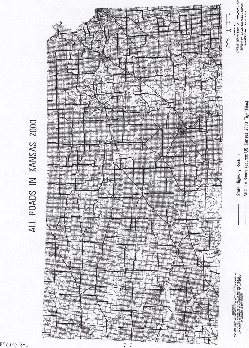
2 Roads, Streets, and Highways - Conditions and Needs With 13, miles of public roads, Kansas ranks fourth among the states in number of public road miles. The magnitude of the Kansas road network is attributable to the fact that the State is large in terms of geographic size and has few natural barriers such as mountain ranges to impede the building of roads. The State developed from an agricultural base that saw a family farm on every 80 or acres, which in turn dictated the need for a road every mile. The map on page 3- demonstrates the density of existing Kansas roads. Even though the State has a large number of roads, the majority of them fall under city and county jurisdiction. The following table presents the breakdown of jurisdictional responsibility and travel on all roads in Kansas. The State Highway System and City Connecting Links (that portion of any State route going through a city) make up 10,380 miles, or just 8 percent of the more than 13,000 miles of public roads in Kansas, yet they accommodate over percent of the travel in the State. The Interstate System (including 8 miles on the Kansas turnpike) in Kansas comprises less than 1 percent of the road mileage total in the State (8 miles), but carries almost percent of the miles traveled at,01,5 daily vehicle miles traveled (DVMT). Table 3-1: Kansas Public Road Miles & Travel By Jurisdiction SYSTEM State Highway City Connecting Links LINE MILES % OF TOTAL MILES DAILY VEHICLE MILES % OF TOTAL TRAVEL,.1 6,13, ,,5.8 County/Township 110,0. 1,113,108. Municipal 13, 10. 0,88,68 6. Turnpike ,, 5.0 State Park Roads , TOTAL 13, ,5, Source: KDOT Selected Statistics,
3
4 The majority of the roads in Kansas are in rural areas of the State. These roads allow access to farms, movement between towns and cities, and travel across the State. Of the 13, public road miles in the State, 1,301 are in rural areas and 10, miles are in urban areas (areas of greater than 5,000 population). In 001, the DVMT on the rural system was,60,1 compared to,,38 on the urban system. This is a key element since roads in urban areas constitute only 8% of the total road miles in the State, but account for 6% of the travel. In Kansas, good roads in both rural and urban areas are a necessity for travel and access to all parts of the State. Kansas ranks third in the number of bridges among the states, totaling, bridges in 000. Of the, bridges, 3,5 (13.%) are classified as structurally deficient Kansas Bridges By jurisdiction State-,13 City- 1,08 County- 1,66-30 State Highway System and,1 (11.%) bridges are classified as functionally obsolete. A structurally deficient bridge is defined as a bridge that is (1), closed because of structural inadequacies; (), posted with a weight limit; or, (3), in immediate need of rehabilitation to remain open. A bridge is defined as functionally obsolete if, although structurally sound, it is no longer adequate to handle the traffic for the road on which it is built. Bridges are also considered to be functionally obsolete if the bridge is narrower than the road it is on, including shoulders. The rural State Highway System consists of, miles, and includes the Interstate, U.S. route numbered highways, and Kansas route numbered highways. KDOT has jurisdictional responsibility over all of these routes, except for the portions of these routes carried by Kansas Turnpike. Interstate, U.S., and Kansas routes have the same funding sources and have similar importance for transportation in Kansas. For the most part, the U.S. routes were named in the 130 s and 10 s to aid travelers in cross-country travel, but have no added significance for funding as compared to Kansas routes. Travel on the State Highway System has continued to grow over the years and that growth shows no sign of abatement. Between 10 and 000, the population of Kansas grew at one-half percent annually, while travel on the State Highway System grew seven times as rapidly, averaging 3. percent annually. The maps on page 3- and 3-5 display the average daily traffic and truck traffic, respectively, on the State Highway System, and the Kansas Turnpike. Commercial truck traffic on the rural State System has grown at a faster rate than that of passenger vehicles. In the years between 6 and 001, commercial truck travel increased 3 percent while car and pickup truck travel grew by percent. In 001, commercial truck travel comprised % of all vehicle miles on the rural State System. 3-3
5 MORTON STEVENS SEWARD STANTON GRANT HAMILTON KEARNY FINNEY HASKELL ELKHART JOHNSON CITY HUGOTON SUBLETTE MEADE GRAY FORD MEADE CIMARRON HODGEMAN NESS LANE SYRACUSE LAKIN GREELEY WICHITA SCOTT WALLACE LOGAN THOMAS LEOTI SCOTT CITY SHERMAN SHERIDAN GOVE OAKLEY GRAHAM DIGHTON GOVE NORTON DECATUR ATWOOD OBERLIN HOXIE CHEYENNE RAWLINS ST. FRANCIS TREGO SHARON SPRINGS TRIBUNE GOODLAND ULYSSES COLBY LIBERAL GARDEN CITY NORTON PHILLIPSBURG SMITH MANKATO HILL CITY STOCKTON OSBORNE BELOIT LACROSSE ELLSWORTH PHILLIPS ROOKS SMITH JEWELL OSBORNE MITCHELL ELLIS ELLSWORTH LINCOLN RUSSELL LINCOLN WAKEENEY RUSSELL HAYS CLARK COMANCHE BARBER EDWARDS STAFFORD RENO PAWNEE RICE BARTON RUSH HARPER KINGMAN ASHLAND NESS CITY KINSLEY LARNED MEDICINE LODGE PRATT ANTHONY LYONS ST. JOHN PRATT KIOWA COLDWATER JETMORE GREENSBURG DODGE CITY GREAT BEND SALINE DICKINSON OTTAWA CLAY MORRIS WABAUNSEE RILEY POTTAWATOMIE NEMAHA MARSHALL WASHINGTON JACKSON REPUBLIC CLOUD MINNEAPOLIS ABILENE CONCORDIA BELLEVILLE WASHINGTON MARYSVILLE SENECA WESTMORELAND ALMA COUNCIL GROVE GEARY CLAY MANHATTAN JUNCTION CITY SALINA WELLINGTON WINFIELD EL DORADO COWLEY CHAUTAUQUA ELK GREENWOOD BUTLER SEDGWICK HARVEY CHASE MARION MCPHERSON SEDAN HOWARD EUREKA LYON MCPHERSON MARION SUMNER COTTONWOOD FALLS EMPORIA HUTCHINSON NEWTON WICHITA BROWN HIAWATHA TROY ATCHISON HOLTON OSKALOOSA LEAVENWORTH SHAWNEE JEFFERSON DOUGLAS JOHNSON WYANDOTTE OTTAWA LYNDON PAOLA DONIPHAN TOPEKA LAWRENCE LEAVENWORTH KANSAS CITY OLATHE ATCHISON MONTGOMERY LABETTE WILSON NEOSHO WOODSON ALLEN BOURBON LINN COFFEY ANDERSON MIAMI FRANKLIN OSAGE OSWEGO CHEROKEE CRAWFORD COLUM YATES IOLA ERIE GIRARD MOUND CITY GARNETT BURLINGTON FREDONIA FORT SCOTT INDEPENDENCE PITTSBURG KINGMAN ALT BYPASS SPUR ALT
6 MORTON STEVENS SEWARD STANTON GRANT HAMILTON KEARNY FINNEY HASKELL ELKHART JOHNSON CITY HUGOTON SUBLETTE MEADE GRAY FORD MEADE CIMARRON HODGEMAN NESS LANE SYRACUSE LAKIN GREELEY WICHITA SCOTT WALLACE LOGAN THOMAS LEOTI SCOTT CITY SHERMAN SHERIDAN GOVE OAKLEY GRAHAM DIGHTON GOVE NORTON DECATUR ATWOOD OBERLIN HOXIE CHEYENNE RAWLINS ST. FRANCIS TREGO SHARON SPRINGS TRIBUNE GOODLAND ULYSSES COLBY LIBERAL GARDEN CITY NORTON PHILLIPSBURG SMITH MANKATO HILL CITY STOCKTON OSBORNE BELOIT LACROSSE ELLSWORTH PHILLIPS ROOKS SMITH JEWELL OSBORNE MITCHELL ELLIS ELLSWORTH LINCOLN RUSSELL LINCOLN WAKEENEY RUSSELL HAYS CLARK COMANCHE BARBER EDWARDS STAFFORD RENO PAWNEE RICE BARTON RUSH HARPER KINGMAN ASHLAND NESS CITY KINSLEY LARNED MEDICINE LODGE PRATT ANTHONY LYONS ST. JOHN PRATT KIOWA COLDWATER JETMORE GREENSBURG DODGE CITY GREAT BEND SALINE DICKINSON OTTAWA CLAY MORRIS WABAUNSEE RILEY POTTAWATOMIE NEMAHA MARSHALL WASHINGTON JACKSON REPUBLIC CLOUD MINNEAPOLIS ABILENE CONCORDIA BELLEVILLE WASHINGTON MARYSVILLE SENECA WESTMORELAND ALMA COUNCIL GROVE GEARY CLAY MANHATTAN JUNCTION CITY SALINA WELLINGTON WINFIELD EL DORADO COWLEY CHAUTAUQUA ELK GREENWOOD BUTLER SEDGWICK HARVEY CHASE MARION MCPHERSON SEDAN HOWARD EUREKA LYON MCPHERSON MARION SUMNER COTTONWOOD FALLS EMPORIA HUTCHINSON NEWTON WICHITA BROWN HIAWATHA TROY ATCHISON HOLTON OSKALOOSA LEAVENWORTH SHAWNEE JEFFERSON DOUGLAS JOHNSON WYANDOTTE OTTAWA LYNDON PAOLA DONIPHAN TOPEKA LAWRENCE LEAVENWORTH KANSAS CITY OLATHE ATCHISON MONTGOMERY LABETTE WILSON NEOSHO WOODSON ALLEN BOURBON LINN COFFEY ANDERSON MIAMI FRANKLIN OSAGE OSWEGO CHEROKEE CRAWFORD COLUM YATES IOLA ERIE GIRARD MOUND CITY GARNETT BURLINGTON FREDONIA FORT SCOTT INDEPENDENCE PITTSBURG KINGMAN ALT BYPASS SPUR ALT
7 In addition to the rapid growth in number of trucks using the State Highway System, the average weight of trucks has grown as well. In 15, the average weight of all loaded and empty trucks was 8,15 pounds. In 001, the average truck weight was,00 pounds - an increase of more than 80 percent. This is significant because many facilities were designed and built prior to 15. Many factors have led to the increased weight of trucks during this time, including the fact that size and weight limits have changed, back-haul restrictions have been lifted, and deregulation of the trucking industry has occurred. KDOT Route Classification System In order to better manage and address the diversity of the Kansas State Highway System, in 8 KDOT developed and adopted a route classification system based on daily traffic, route continuity, access to major cities, trip length and route spacing. The System is divided into five classification levels (A through E routes) as described below. The map on page 3- displays the route classification system. The principal purpose of the route classification system is to ensure that limited resources are directed to the highest priority routes and to ensure that the highest percentage possible of the traveling public drives on roadways appropriate to the purpose of their trip. The Route Classification System is one of the factors considered in a variety of department activities including project selection, establishing priorities in the Railroad Grade Separation program, and setting design standards. CLASS A -- The Interstate System, including the Kansas Turnpike. CLASS B -- This class, along with Class A Routes, serves the most important corridors of statewide and interstate travel. Nearly all cities with a population over 10,000 are within ten miles of one of these routes. There is a higher proportion of drivers that are unfamiliar with the particular features of the route, making continuity of design over major sections of the route very important. CLASS C The principal function is to provide person and commodity movement between regions of the State. Route continuity is less important than for Class B Routes and design elements of the routes can change at major activity points and major junctions. CLASS D This class contains routes that serve the combined role of inter-county movement and access to smaller cities. Almost no interstate service is provided, except as access to an Interstate route. CLASS E This class is made up of stub routes and routes whose service is limited almost exclusively to local travel. The average trip length is generally very short but may vary widely, depending on the nature of the local area served. 3-6
8 0 10 O 10 MILES 30 PREPARED BY THE KANSAS DEPARTMENT OF TRANSPORTATION BUREAU OF TRANSPORTATION PLANNING STP01.DGN JANUARY, 001 USING CANSYS DATABASE 5/ KDOT makes no warranties, guarantees, or representations for accuracy of this information and assumes no liability for errors or omissions.
9 ROUTE CLASSIFICATION Table 3-: Miles and Travel by Route Classification, 001 MILES % OF MILES TOTAL DAILY VEHICLE MILES TRAVELED (VMT) % OF TOTAL VMT TOTAL DAILY TRUCK MILES TRAVELED % of TOTAL TRUCK VMT A 8. 8.,01,8 3.5,85,3 1. B, ,1, ,86,. C,5.06.,, ,11,0 1. D 3, ,03, , E 1, ,61, ,88. TOTAL 10, ,6, ,, Notes: Includes the Kansas Turnpike and City Connecting Links. Source: Kansas Department of Transportation CANSYS Database, December, 001 National Highway System The Intermodal Surface Transportation Efficiency Act (ISTEA) of 11 eliminated the historical Federal-aid System and created the National Highway System (NHS) and other Federal-aid highway categories. The NHS was selected in consultation with appropriate local officials; it consists of highway routes and connections to transportation facilities depicted on the maps submitted by the Secretary of Transportation to Congress on May, 16. Highways designated as part of the Interstate System are included in the NHS. FHWA describes the NHS as the backbone of our nation's transportation network in the 1st Century. As described in ISTEA, the purpose of the NHS is to "provide an interconnected system of principal arterial routes which will serve major population centers, international border crossings, ports, airports, public transportation facilities and other major travel destinations; meet national defense requirements; and serve interstate and interregional travel." The NHS is not a system of new highways. In fact, 8 percent of the NHS mileage already exists. The approximate size of the NHS is over,000 miles nationwide, which is roughly percent of all U.S. roads. In 000, the NHS included 1,86 rural miles and approximately 1, urban miles. 3-8
10 MORTON STEVENS SEWARD STANTON GRANT HAMILTON KEARNY FINNEY HASKELL ELKHART JOHNSON CITY HUGOTON SUBLETTE MEADE GRAY FORD MEADE CIMARRON HODGEMAN NESS LANE 1 SYRACUSE LAKIN GREELEY WICHITA SCOTT WALLACE LOGAN THOMAS 6 5 LEOTI SCOTT CITY SHERMAN SHERIDAN GOVE OAKLEY GRAHAM DIGHTON 6 ALT GOVE 8 85 NORTON DECATUR 1 3 ATWOOD OBERLIN HOXIE 11 CHEYENNE RAWLINS ST. FRANCIS TREGO 6 SHARON SPRINGS TRIBUNE GOODLAND ULYSSES COLBY LIBERAL GARDEN CITY 61 6 NORTON PHILLIPSBURG SMITH 11 MANKATO 8 18 HILL CITY 8 STOCKTON OSBORNE 1 BELOIT LACROSSE BYPASS ELLSWORTH PHILLIPS ROOKS SMITH JEWELL OSBORNE MITCHELL ELLIS ELLSWORTH LINCOLN RUSSELL LINCOLN 8 8 WAKEENEY RUSSELL HAYS CLARK COMANCHE BARBER EDWARDS STAFFORD RENO PAWNEE RICE BARTON RUSH HARPER KINGMAN ASHLAND NESS CITY KINSLEY LARNED MEDICINE LODGE 1 1 PRATT ANTHONY LYONS ST. JOHN 6 PRATT KIOWA COLDWATER JETMORE GREENSBURG DODGE CITY GREAT BEND SALINE DICKINSON OTTAWA CLAY MORRIS WABAUNSEE RILEY POTTAWATOMIE NEMAHA MARSHALL WASHINGTON JACKSON REPUBLIC CLOUD MINNEAPOLIS ABILENE CONCORDIA BELLEVILLE WASHINGTON MARYSVILLE SENECA WESTMORELAND ALMA COUNCIL GROVE GEARY. CLAY. MANHATTAN JUNCTION CITY SALINA WELLINGTON 166 WINFIELD EL DORADO COWLEY CHAUTAUQUA ELK GREENWOOD BUTLER SEDGWICK HARVEY CHASE MARION MCPHERSON SEDAN HOWARD EUREKA LYON SPUR. MCPHERSON MARION SUMNER COTTONWOOD FALLS EMPORIA HUTCHINSON NEWTON WICHITA BROWN HIAWATHA TROY ATCHISON HOLTON OSKALOOSA LEAVENWORTH SHAWNEE JEFFERSON DOUGLAS JOHNSON WYANDOTTE OTTAWA LYNDON PAOLA 0 DONIPHAN 35 TOPEKA LAWRENCE LEAVENWORTH KANSAS CITY OLATHE ATCHISON 5 MONTGOMERY LABETTE WILSON NEOSHO WOODSON ALLEN BOURBON LINN COFFEY ANDERSON MIAMI FRANKLIN OSAGE OSWEGO CHEROKEE CRAWFORD COLUM ALT YATES IOLA ERIE GIRARD MOUND CITY GARNETT 16 5 BURLINGTON FREDONIA FORT SCOTT INDEPENDENCE PITTSBURG KINGMAN 66 5 NATIONAL HIGHWAY SYSTEM NATIONAL HIGHWAY SYSTEM NON-NATIONAL HIGHWAY SYSTEM
11 Nationally, the NHS carries approximately 0 percent of all vehicle traffic, 5 percent of commercial truck traffic, and 80 percent of the tourist traffic. In addition, it is estimated that 5 percent of the nation's businesses are located within five miles of the National Highway System. The NHS in Kansas consists of 3,3 miles, representing only.8 percent of all public roads in the State. Of this total, 3,31 miles are located in rural areas, and 16 miles are located in urban areas. The daily travel on the National Highway System in Kansas for 001 was 33. million daily vehicle miles of travel. This amounts to about percent of the daily travel in Kansas. In 001, the heavy commercial traffic on the NHS was 5. million daily vehicle miles of travel, which is over 60 percent of the commercial traffic in Kansas. Highway System Planning Kansas and its neighboring states have several corridors that are experiencing growth in both commercial truck traffic and overall traffic. While some of these routes are contained totally within a state, many cross state borders. In order for these highways to continue to move traffic safely and efficiently, additional capacity in the form of additional lanes or the construction of passing lanes will be needed within the next 0 years. The importance of maintaining adequate capacity on a highway system is to provide smooth traffic flow. The benefits of smooth traffic flow include reduced travel time, reduced driver fatigue, increased reliability and enhanced safety. Increased reliability is becoming more important to businesses that rely on Just-in-Time delivery of materials as part of the manufacturing process. Planning for the long-range vision of a highway allows individual projects, selected through KDOT s priority formula process, to be designed to fit the ultimate goal for the route. Consideration can be made to preserving sufficient right-of-way for long-range improvements and establishing access control before significant development occurs. In the long run, this lowers right-of-way costs and is less disruptive to businesses that locate near highway access points. Being located in the geographic center of the 8 contiguous United States, travel patterns in Kansas are heavily influenced by out-of-state traffic and the corridors available to that traffic. The Interstate routes such as I-0 and I-35 are obvious major carriers for this traffic, but other routes carry travelers and freight for long distances. For the purposes of this long-range plan, Colorado, Nebraska, Missouri, and Oklahoma were contacted regarding their plans for expanding routes that lead to Kansas. A map showing these plans is shown on page 3-1. Nebraska, in addition to creating a US- expressway corridor from Kansas to Yankton, South Dakota, is also considering a connection from US- at Norfolk to I- at Sioux City, Iowa, which could facilitate Canadian traffic as well as traffic from the Twin Cities. Kansas has completed the -lane expressway expansion of US- from Concordia north to Nebraska. The Nebraska Department of Roads also plans to create a -lane expressway from Omaha south to Auburn on US-5. While 3-10
12 this would not connect to Kansas, traffic should be monitored along the US-5 corridor as Holton and the Native American casinos have generated considerable growth in traffic. The Missouri border is by far the largest source of interstate traffic to Kansas. The most traveled border crossings are already four lanes: the Interstates in Kansas City, and US- in St. Joseph. Missouri River crossings are two points of expansion: the US-5 bridge at Atchison and the K- bridge at Leavenworth. The US-5 bridge at Atchison will be replaced as a System Enhancement. This will facilitate traffic moving between St. Joseph and Topeka. The Leavenworth bridge is the western end of the S.R. corridor being considered for improvement by the Missouri Department of Transportation (MoDOT). This is a vital intermodal route linking Leavenworth with the Kansas City International Airport. MoDOT is also considering expansion of the east-west corridors, including widening of I-0 between Kansas City and St. Louis and improving US- to freeway standards across the state. US- may serve as a relief route for I-0 traffic from Kansas City to Chicago, but it may also direct more traffic toward northern Kansas along US-. Oklahoma does not have expansion plans for any north-south routes leading to Kansas, but it is worth noting that US-5 is mostly four lanes from Tulsa north to Kansas. US-5 and US-16 both lead to Tulsa, but only US-16 connects to Kansas City. Oklahoma has plans to expand US-5 in the Panhandle to four lanes; combined with Texas and New Mexico s improvement plans this is a vital section to connect US-5 to Interstate 0 near Tucumcari, New Mexico. Colorado plans to expand US- to a -lane expressway from Pueblo to La Junta. Other sections near Lamar and Las Animas are already expressways. Along with KDOT s plans to study US- from Garden City east, this could possibly create a key corridor connecting Wichita to the Front Range of the Rocky Mountains. 3-11
13 3-1 US-5 Figure 3.6: Regional Corridors Affecting Kansas South Dakota Minnesota Wisconsin Wyoming Nebraska US- US- to I- Connection Iowa US- Illinois Colorado US- Kansas Missouri US- US-5 Study or Proposed Corridor Funded Corridor Interstate New Mexico Oklahoma Arkansas Multi-lane State and US Route -lane State and US Route
14 Conditions and Needs Pavement Surface needs have been and will continue to be KDOT's highest priority. Efforts to maintain and improve surfaces consume a large portion of KDOT's time, energy, and resources. Routine maintenance efforts and substantial (contractor-performed) maintenance and major modifications programs all have as their primary objective to maintain or improve the pavements of the State Highway System. KDOT annually measures the condition of our highway pavement surfaces. The primary use of this data is decision support for project selection, but it also serves as an indicator of performance provided to the traveling public. Data elements include roughness, cracking, and rutting on asphalt surfaces and roughness, joint distress, and faulting on concrete surfaces. The roughness and distress data are combined into a threelevel index called performance level. Performance Level One is for pavements that are in good condition and only need routine or light preventative maintenance. Performance Level Three pavements are in poor condition and need significant work. The data elements and performance level definitions have been kept stable since KDOT began collecting this data so changes in condition could be tracked over time. The following chart shows how the percentage of KDOT managed roadways in the good and poor performance levels have changed over time for both the Interstate and non-interstate highways. Clearly, the percentage of highways with good pavement surfaces has improved and the corresponding poor highway surface mileage has decreased. Figure 3- Kansas Pavement Performance Level (PL) % 0.00% Interstate PL1 (Good) Non-Interstate PL1 (Good) Interstate PL3 (Poor) Non-Interstate PL3 (Poor) % of Highway System in Leve 80.00% 0.00% 60.00%.00% 0.00% 30.00% 0.00% 10.00% 0.00%
15 Shoulders The shoulder is that portion of the roadway adjacent to the travel lanes, and may be turf, gravel, or paved. Shoulders provide lateral support to the pavement as well as safety benefits. In some cases, the shoulder can accommodate bicyclists and other slow-moving vehicles. As part of the External Survey in 001, KDOT conducted Road Rallies in which citizen volunteers determined what attributes are important on Kansas roads, and how expectations differ by route classification. For example, the public has higher expectations for the smoothness of Interstates (Class A) than it holds for Class E routes. However, shoulder type and width proved to be important, regardless of classification. The condition or type of the shoulder can significantly affect a driver s perception of safety (as a means of crash avoidance) and therefore, comfort level. The participants surveyed did not consider turf shoulders to be acceptable, even for Class D and E routes. Also, for -lane B and C routes, eight feet appeared to be the minimum acceptable paved shoulder width. By these standards, a very large percentage of the State Highway System does not meet our customers expectations. Capacity Traffic has increased on the majority of Kansas highways. Growth has occurred at an even faster rate on highways in urban areas and routes connecting the larger, growing cities. For a given highway, its level of service generally declines as traffic increases. On two-lane highways, this level of service is measured by the percent of time that a vehicle spends following another vehicle. In the rolling terrain of eastern Kansas, the vehicles are more likely to spend time following a slower vehicle because large vehicles have more difficulty climbing hills, and also the hills decrease opportunities for passing by restricting sight distances. Some of the Major Modification projects improve these situations by flattening roads and adding intermittent passing lane sections, but as traffic volumes increase, these improvements become ineffective. For very high-volume roads, widening to four-lane expressways or freeways may be the only improvement that would significantly relieve congestion and improve safety. The Major Modification and System Enhancement programs contain several of these expansion projects; some are funded for construction, while others look toward the future by providing funds for preliminary engineering and/or right-of-way acquisition, so that when traffic volumes warrant and construction funds become available, a feasible corridor is available. This preservation of a corridor also allows local governments to make prudent land-use decisions. Bridge Needs The State Highway System contains,13 bridges, of which 3,1 are span bridges and 1,1 are box bridges. Of the 3,1 span bridges, 6 will be over years old and an additional 80 will be over 0 years old when the CTP ends in 00. Bridges, in general, have a life expectancy of to 5 years depending on the bridge type. Span bridges generally have a life of years, but their decks generally are considered to have a life of 3-1
16 only 30 years. At anticipated funding levels, KDOT could only perform bridge replacement or major rehabilitation work on an 80-year cycle. Future Needs Although the CTP is often called the largest public works program in Kansas history, deficiencies will remain in our highway system in 010 after the projects funded by the ten-year CTP have been constructed. In addition, many more needs will accrue in the years after 010 as traffic volumes continue to grow and pavements and bridges continue to deteriorate. Furthermore, there will be needs for new facilities such as additional interchanges, bypasses, or additional capacity modifications such as new fourlane corridors or the addition of lanes on existing two-lane roads. Kansas Turnpike The 8-mile Kansas Turnpike connects the four largest cities in the State. The facility runs from the Kansas City area west through Lawrence to Topeka, then south to Wichita, ending at the Oklahoma State line. It was opened to traffic in 1 and preceded the building of the Interstate system. Operation of the Kansas Turnpike is governed by the Kansas Turnpike Authority (), a five person board which consists of two members from the general public, each appointed for a four-year term by the Governor, and three members who serve on the by virtue of their respective leadership positions in other transportation concerns: the Secretary of the Kansas Department of Transportation; the Chairman of the Kansas Senate Transportation and Utilities Committee; and a member of the Kansas House Transportation Committee appointed by the Speaker of the House. Over million passenger cars and nearly four million commercial vehicles traveled on the Turnpike in 001. The average trip length on the Turnpike for all vehicles in 001 was miles. Passenger vehicles comprised 86 percent of the total number of vehicles and percent of the total miles traveled on the Kansas Turnpike during the year. Since its beginning, the Kansas Turnpike has continued to evolve in response to the needs of the traveling public. Interchanges have been added and service areas have been expanded and modernized. System wide improvements have been made for increased motorist safety such as the addition of a concrete barrier median to the entire length of the Turnpike. Recent improvements include the addition of the K-6 interchange in Wichita, the construction of the I-0/K- system interchange in east Topeka, the total rebuild of the East Topeka service area, and the relocation/reconstruction of the East Terminal toll plaza. As one of the recommendations from the previous Kansas Long-Range Transportation Plan, KDOT has included the Turnpike Authority in joint planning efforts. The largest example of this joint planning is the KawConnects Major Corridor Study, which examined all modes of transportation between the Topeka and Kansas City metro areas from 3-
17 the present to the year 0. The jointly funded study was precipitated by the rapid travel growth on east-west roadways in the area, as well as new large developments in the corridor, such as the Kansas Speedway and the former Sunflower Ammunition Depot south of DeSoto. A travel-demand computer model was created to simulate traffic on the highways, and this allowed for the analysis of different highway improvements, such as building new highways or widening existing ones. While non-highway improvements (commuter rail, inter-city transit) were also studied, significant congestion reduction for the year 0 cannot be achieved without adding capacity to I-0 (carried by the Kansas Turnpike) and K- 10 between Lawrence and the southern Kansas City metro area. recently completed a Long-Term Needs Study, which examined the Turnpike s maintenance and construction needs for the next 10 to 0 years. The study indicated that the section of roadway between Topeka and Lawrence would need to be widened to six lanes if an acceptable level of service is to be maintained. The remaining section from Lawrence to Kansas City may have to be widened depending upon future Kansas Department of Transportation projects on parallel roadways and other developments in the corridor. Another concern for the Turnpike is the condition of the Kansas River bridges in Lawrence. According to the Long-Term Needs Study, these bridges must be replaced by 01 and currently need strengthening on some of the critical members of the truss sections. As a continuation of the planning process, Turnpike officials have begun work on preliminary assessments and conceptual designs for widening and the complete bridge replacements The chart below shows usage trends for the for selected years from 1 to Table 3-3: Usage ANNUAL NUMBER OF VEHICLES (in 1000 s) MILES TRAVELED (in 1000 s) Year Passenger Vehicles Commercial Vehicles Total Vehicles Passenger Vehicles Commercial Vehicles Total Vehicles 1 3,11 0 3,613 1,688,8, 16 6,858 1,8 33, 60,0 35,651 1,6, 11,0,05 1,33 533, 13,585,3 16, 5,61 5,3 1,5 1, 3,58,,0, 1,16,8 001,1 3,5,86 1,006,66,58 1,, Source: 001 Selected Statistics, page 3 and Annual Report. 3-16
18 Local Roads and Bridges Cities and counties across the State have an enormous task in maintaining and upgrading their roads and bridges. The cities have jurisdiction over 13, miles of road and 1,08 bridges. The counties have jurisdiction over 110,0 miles of roadway and 1,66 bridges. In total, 0 percent of the roads and 80 percent of the bridges in the State are the direct responsibility of cities and counties. Since there are 105 counties and 6 incorporated cities in the State, it is often difficult to assemble information on local road conditions and needs. However, more information is available on local bridges because they are inspected on a two-year cycle using a standardized format developed in conjunction with the National Bridge Inventory (NBI) program. Even though most of the local bridges are located in rural areas and carry a low volume of traffic, they are necessary components of the local transportation network. Of the State's 0,30 local jurisdiction bridges, over 5 percent (,30) carry fewer than 100 vehicles per day. Over 0 percent of those bridges (,6) carry fewer than 0 vehicles per day. Unfortunately, many of these bridges were not designed to carry today's vehicle weights and are posted with a load or other-use restriction. Age of Local Bridges by Percent 11% % 60% Figure to 51 to As Figure 3-8 indicates, 0 percent of the local city and county bridges are over years old. More local bridges (3,305) were built in the 130 s than any other decade. Because of these factors, bridge maintenance and replacement funding is a constant challenge for local officials. 3-1
ANNUAL BUSINESS FORMATION REPORT January 11, 2013
 ANNUAL BUSINESS FORMATION REPORT January 11, 2013 When I became Kansas Secretary of State in January of 2011, one of my first goals was to charge my staff with analyzing the applicable laws and policies
FOR RELEASE: WEDNESDAY, OCTOBER 8 AT 4 PM
 Kansas In Kansas, interviews with 1,025 adult Americans conducted by telephone by ORC International on October 2-6, 2014. The margin of sampling error for results based on the total sample is plus or minus
Kansas Active Livescans
 Kansas Active Livescans County Agency City LS Company Installation Date Status Allen Allen County Sheriff Iola CROSSMATCH 12/10/2004 Act Atchison Atchison County Sheriff Atchison CROSSMATCH 12/15/2005
OFFICE OF THE KANSAS SECRETARY OF STATE 2018 General Election Advance Voting Times & Locations
 OFFICE OF THE KANSAS SECRETARY OF STATE 2018 General Election Advance Voting Times & Locations ALLEN COUNTY Allen County Clerk s Office 1 N Washington Iola, Kansas 66749 October 17-19, 2018 from 7:45 AM
OFFICE OF THE KANSAS SECRETARY OF STATE 2016 PRIMARY ADVANCE VOTING SITES
 OFFICE OF THE KANSAS SECRETARY OF STATE 2016 PRIMARY ADVANCE VOTING SITES ALLEN COUNTY Allen County Courthouse, 1 N. Washington, Iola, KS 66749 o Hours: Monday Friday 7:30 AM- 5:00 PM ANDERSON COUNTY Anderson
DECEMBER 2007 SIGNIFICANT FACTS AND TRENDS
 KANSAS DEPARTMENT OF TRANSPORTATION BUREAU OF TRANSPORTATION PLANNING DECEMBER 0 SIGNIFICANT FACTS AND TRENDS DEPARTMENTOF DEPARTMENTOFTRANSPORTATION TRANSPORTATION KA N SAS Contact the Traffic and Field
KANSAS DEPARTM ENT OF TRANSPORTATION BUREAU OF TRANSPORTATION PLANNING JANUARY 2017 SIGNIFICANT FACTS AND TRENDS
 KANSAS DEPARTM ENT OF TRANSPORTATION BUREAU OF TRANSPORTATION PLANNING JANUARY 17 SIGNIFICANT FACTS AND TRENDS Month Jan Feb Mar Apr May Jun Jul Aug Sep Oct Nov Dec Average Travel on the Kansas State Highway
JUNE 2007 SIGNIFICANT FACTS AND TRENDS
 KANSAS DEPARTMENT OF TRANSPORTATION BUREAU OF TRANSPORTATION PLANNING JUNE 07 SIGNIFICANT FACTS AND TRENDS Travel on the Kansas State Highway System Daily Vehicle Miles % Change (In Millions) 06 to 07
KANSAS DEPARTM ENT OF TRANSPORTATION BUREAU OF TRANSPORTATION PLANNING NOVEM BER 2018 SIGNIFICANT FACTS AND TRENDS
 KANSAS DEPARTM ENT OF TRANSPORTATION BUREAU OF TRANSPORTATION PLANNING NOVEM BER 018 SIGNIFICANT FACTS AND TRENDS Month Jan Feb Mar Apr May Jun Jul Aug Sep Oct Nov Dec Average Travel on the Kansas State
KANSAS DEPARTM ENT OF TRANSPORTATION BUREAU OF TRANSPORTATION PLANNING DECEM BER 2018 SIGNIFICANT FACTS AND TRENDS
 KANSAS DEPARTM ENT OF TRANSPORTATION BUREAU OF TRANSPORTATION PLANNING DECEM BER SIGNIFICANT FACTS AND TRENDS Month Jan Feb Mar Apr May Jun Jul Aug Sep Oct Nov Dec Average Travel on the Kansas State Highway
DATE TIME TROOP LOCATION TYPE NOTES 1/1/ E U-53, Haskell/Seward Counties Saturation Patrol 1/3/ E Finney County
 DATE TIME TROOP LOCATION TYPE NOTES 1/1/2017 1900-2200 E U-53, Haskell/Seward Counties Saturation Patrol 1/3/2017 1300-1500 E Finney County Saturation Patrol 1/5/2017 0700-0900 F U-160, Sumner County Speed
Estimated 2014 ARC-CO Wheat Payments Kansas and Oklahoma 1
 Disclaimer: This web page is designed to aid farmers with their marketing and risk management decisions. The risk of loss in trading futures, options, forward contracts, and hedge-to-arrive can be substantial
Kansas. Spring Turkey. Hunting Atlas. Spring Turkey. Seasons. Includes Walk-In Hunting Access (WIHA) areas and public lands (state and federal)
 areas and public lands (state and federal)") 20 Kansas Spring Turkey Hunting Atlas Spring Turkey Seasons YOUTH/DISABILITY April 1-1, 20 ARCHERY April -1, 20 REGULAR April - May, 20 ksoutdoors.com Includes Walk-In Hunting Access (WIHA) areas and public
20 Kansas Spring Turkey Hunting Atlas Spring Turkey Seasons YOUTH/DISABILITY April 1-1, 20 ARCHERY April -1, 20 REGULAR April - May, 20 ksoutdoors.com Includes Walk-In Hunting Access (WIHA) areas and public
KS Cities & Towns Lifeline Provider ID No. ID No. Providers Approved to Offer Lifeline Discounts*
 ABILENE 3, 6, 8, 10, 11, 12, 14, 15, 16, 17, 18 1 PIONEER CELLULAR ANDOVER 8, 9, 10, 11, 13, 14, 15, 16, 17, 18 2 NE COLORADO CELLULAR, INC. ANTHONY 1, 8, 11, 12, 14, 16, 18 3 NEX-TECH, INC. ARKANSAS CITY
Table of Contents. Introduction Day Survey Participants...3
 August 2, 27 Table of Contents Introduction...................... 3-Day Survey Participants..............3 State Regions Map.................. 4 Survey Results by Region: KC Metro.........................
Kansas Department of Revenue Office of Policy and Research City/County Distributions - Calendar Year Summary (based on issued month)
") Rate Date 2013 2014 change Allen County 1.250% Apr-11 $2,153,590.33 $2,363,033.90 9.7% Anderson County 1.500% Apr-07 $1,157,154.48 $1,225,585.79 5.9% Atchison County 1.250% Jan-07 $1,988,547.38 $2,094,541.42
Rate Date 2013 2014 change Allen County 1.250% Apr-11 $2,153,590.33 $2,363,033.90 9.7% Anderson County 1.500% Apr-07 $1,157,154.48 $1,225,585.79 5.9% Atchison County 1.250% Jan-07 $1,988,547.38 $2,094,541.42
Hunting Atlas. Kansas FALL 2018 SPRING 2019 FALL 2018 SPRING Includes Walk-In Hunting Areas (WIHA) and Public Lands (state and federal)
 and Public Lands (state and federal)") Kansas 2018-1 Hunting Atlas FALL 2018 SPRING 201 FALL 2018 CHECK OUT OTHER HUNTING INFORMATION AT OUR WEBSITE: ksoutdoors.com SPRING 201 Includes Walk-In Hunting Areas (WIHA) and Public Lands (state and
Kansas 2018-1 Hunting Atlas FALL 2018 SPRING 201 FALL 2018 CHECK OUT OTHER HUNTING INFORMATION AT OUR WEBSITE: ksoutdoors.com SPRING 201 Includes Walk-In Hunting Areas (WIHA) and Public Lands (state and
Roadway depa epa tu tu e
 Roadway Departure Introduction According to the Federal Highway Administration, a roadway departure crash is a non-intersection event that occurs after a vehicle crosses an edge line or center line, or
JONESBORO HIGHWAY 63 HIGHWAY 18 CONNECTOR STUDY
 JONESBORO HIGHWAY 63 HIGHWAY 18 CONNECTOR STUDY Craighead County May 2007 JONESBORO HIGHWAY 63 HIGHWAY 18 CONNECTOR STUDY Craighead County May 2007 Prepared by Planning and Research Division Arkansas State
Kentucky s Surface Transportation System
 Kentucky s Surface Transportation System ROAD AND BRIDGE CONDITIONS, TRAFFIC SAFETY, TRAVEL TRENDS, AND NEEDS MARCH 2018 PREPARED BY WWW.TRIPNET.ORG Founded in 1971, TRIP of Washington, DC, is a nonprofit
STUDY PROCESS & SCHEDULE
 STUDY PROCESS & SCHEDULE Route Centennial Bridge Study KDOT Project No. -52 KA-3229-01 STUDY OVERVIEW STUDY SCHEDULE The Kansas Department of Transportation (KDOT) has identified a future need to replace
PUBLIC ATTENDANCE CENTERS IN ALPHABETICAL ORDER HIGH SCHOOLS
 PUBLIC ATTENDANCE CENTERS IN ALPHABETICAL ORDER 500 Reach Kansas City - 500 Abilene Abilene - 435 Andale Renwick - 267 Anderson County Jr/Sr Garnett - 365 Andover Central Andover - 385 Andover ecademy
2009 KANSAS TRAFFIC ACCIDENT FACTS BOOK
 2009 KANSAS TRAFFIC ACCIDENT FACTS BOOK Kathleen Sebelius, Governor Deb Miller, Secretary of Transportation Quick Facts Traffic 348 Fatal 13,925 Injury 46,900 Property-Damage-Only 61,173 All Persons Involved
Report 131 External Monthly Letting List
 All Dollar Amounts in $1, s d Costs Are For Planning Purposes Only; They Are Not The Engineer s Letting Date 218 Apr K123 Decatur KA-4864-1 K-123: Beginning at the Sheridan/Decatur 3.5 AL 2 33 33 Line
Date Team (Won) Scores Team 11/30/2017 Aquinas TMP Hays
 Scores Team 11/30/2017 Aquinas TMP Hays") Date Team (Won) Scores Team (Loss) @ 11/30/2017 Aquinas 43-30 TMP Hays 12/1/2017 Ellis 48-43 Phillipsburg Ellis 12/1/2017 Hill City 50-37 Stockton Hill City 12/1/2017 Norton 25-22 Oakley Norton 12/1/2017
Date Team (Won) Scores Team (Loss) @ 11/30/2017 Aquinas 43-30 TMP Hays 12/1/2017 Ellis 48-43 Phillipsburg Ellis 12/1/2017 Hill City 50-37 Stockton Hill City 12/1/2017 Norton 25-22 Oakley Norton 12/1/2017
Guardrail and Bridge Rail Recommendations for Very Low-Volume Local Roads in Kansas
 Report No. KS-14-16 FINAL REPORT December 2014 Guardrail and Bridge Rail Recommendations for Very Low-Volume Local Roads in Kansas Ronald J. Seitz, P.E. Tod Salfrank Kansas Department of Transportation
2012 Chapter Presidents
 Area 1, Chapter 2 Topeka, Topeka Mr. James F. Miller 7220 SW Asbury, Apt 219W Topeka, KS 66614-6058 snyderfan89@sbcglobal.net Telephone: 785-478-0651 Area 4, Chapter 138 Wichita, Wichita Mr. Dow M. Summers
FUTURE MOBILITY IN TEXAS: The Cost of Meeting the State s Need for Safe and Efficient Mobility
 FUTURE MOBILITY IN TEXAS: The Cost of Meeting the State s Need for Safe and Efficient Mobility OCTOBER 2012 202-466-6706 www.tripnet.org Founded in 1971, TRIP, of Washington, DC is a nonprofit organization
Chapter 4 Traffic Analysis
 Chapter 4 Traffic Analysis PURPOSE The traffic analysis component of the K-68 Corridor Management Plan incorporates information on the existing transportation network, such as traffic volumes and intersection
7220 SW Asbury 3000 Oxford Rd
 Area 1 - Chapter 2, Topeka Topeka Area 1 - Chapter 378, Freestate Lawrence Mr. James F. Miller Mr. Thomas L. Huntzinger 7220 SW Asbury 3000 Oxford Rd Topeka, KS 66614-6058 Lawrence, KS 66049-2829 snyderfan89@sbcglobal.net
Sponsored by the Office of Traffic and Safety of the Iowa Department of Transportation NOVEMBER 2001 CTRE
 PAVED SHOULDERS ON PRIMARY HIGHWAYS IN IOWA: AN ANALYSIS OF SHOULDER SURFACING CRITERIA, COSTS, AND BENEFITS EXECUTIVE SUMMARY Sponsored by the Office of Traffic and Safety of the Iowa Department of Transportation
Kansas City Metro Transportation Snapshot Data for the transportation planning boundary
 Kansas City Metro Transportation Snapshot Data for the transportation planning boundary Total eight-county population: 1,993,490 KS counties: 861,450 MO counties: 1,132,040 Miami: 32,964 Leavenworth: 80,204
WYDOT DESIGN GUIDES. Guide for. NHS Arterial (Non-Interstate)
") WYDOT DESIGN GUIDES Guide for NHS Arterial (Non-Interstate) 2014 GUIDE FOR NATIONAL HIGHWAY SYSTEM (NHS) HIGHWAYS (NHS ARTERIALS, Non-Interstate) PRESERVATION REHABILITATION RECONSTRUCTION INTRODUCTION
WYDOT DESIGN GUIDES Guide for NHS Arterial (Non-Interstate) 2014 GUIDE FOR NATIONAL HIGHWAY SYSTEM (NHS) HIGHWAYS (NHS ARTERIALS, Non-Interstate) PRESERVATION REHABILITATION RECONSTRUCTION INTRODUCTION
Chapter 5 Future Transportation
 Chapter 5 Future Transportation The Future Land Use Plan identifies the desired land use designations. The land uses desired for Crozet depend, in large part, on the success of the transportation system,
TRANSPORTATION & MOBILITY
 TRANSPORTATION & MOBILITY ROADWAY SYSTEM There are approximately 40 miles of roadways in Manitou Springs. For planning purposes, roadways are typically assigned a functional classification which defines
In Collaboration with: City of Belton Cass County FHWA Johnson County KDOT MoDOT City of Olathe City of Overland Park
 In Collaboration with: City of Belton Cass County FHWA Johnson County KDOT MoDOT City of Olathe City of Overland Park I. Background During the Johnson County Board of County Commissioner s (JCBOCC) meeting
WYDOT DESIGN GUIDES. Guide for. Non-NHS State Highways
 WYDOT DESIGN GUIDES Guide for Non-NHS State Highways 2014 GUIDE FOR Non-NATIONAL HIGHWAY SYSTEM (Non-NHS) STATE HIGHWAYS PRESERVATION REHABILITATION RECONSTRUCTION INTRODUCTION This Guide is directed to
Tulsa Metropolitan Area LONG RANGE TRANSPORTATION PLAN
 Tulsa Metropolitan Area LONG RANGE TRANSPORTATION PLAN Indian Nations Council of Governments August 2005 CONTACTING INCOG In developing the Destination 2030 Long Range Transportation Plan, INCOG s Transportation
Key Findings & Corridor Highlights
 The PA 358 Corridor Greenville to I-79 The PA 358 Corridor connects the Borough of Greenville in northwest Mercer County with I-79 to the east. For much of the way it follows the Shenango and Little Shenango
THE I-79 CORRIDOR. I-79 provides motorists with connections to the following major highways: I-80, PA 358, PA 965 and PA 208.
 The I-79 Corridor Pittsburgh to Erie Regional Thruway I-79 was constructed through Mercer County in the early 1960s. The portion north of PA 965 opened in 1961 and the segment south of PA 965 the following
o n - m o t o r i z e d transportation is an overlooked element that can greatly enhance the overall quality of life for the community s residents.
 N o n - m o t o r i z e d transportation is an overlooked element that can greatly enhance the overall quality of life for the community s residents. 84 Transportation CHAPTER 11 INTRODUCTION Transportation
FUTURE MOBILITY IN RHODE ISLAND:
 FUTURE MOBILITY IN RHODE ISLAND: Meeting the State s Need for Safe and Efficient Mobility October 2010 Prepared by: TRIP 1726 M Street, NW, Suite 401 Washington, D.C. 20036 202-466-6706 (voice) 202-785-4722
Regional Transportation Needs Within Southeastern Wisconsin
 Regional Transportation Needs Within Southeastern Wisconsin #118274 May 24, 2006 1 Introduction The Southeastern Wisconsin Regional Planning Commission (SEWRPC) is the official areawide planning agency
91
 90 91 92 93 94 95 96 97 98 99 100 101 102 103 104 105 106 As previously depicted in Exhibit 4-J, vehicular accidents are shown along Forrester Road. The contributing factors may be due to its current two
Proposed Project I 35 from Denton to Cooke County Line
 Proposed Project I 35 from Denton to Cooke County Line The existing I 35 facility is four lanes from I 35E/I 35W to Farm to Market Road (FM) 3002. The purpose of the proposed project is to increase capacity
AASHTO Use Only Establishment of a U.S. (Interstate) Route IH 69 Action taken by SCOH: Extension of a U.S. (Interstate)Route
 Route IH 69 Action taken by SCOH: Extension of a U.S. (Interstate)Route") American Association of State Highway and Transportation Officials An Application from the State Highway or Transportation Department of Texas for: Elimination of a U.S. (Interstate) Route AASHTO Use Only
American Association of State Highway and Transportation Officials An Application from the State Highway or Transportation Department of Texas for: Elimination of a U.S. (Interstate) Route AASHTO Use Only
City of Wayzata Comprehensive Plan 2030 Transportation Chapter: Appendix A
 A1. Functional Classification Table A-1 illustrates the Metropolitan Council s detailed criteria established for the functional classification of roadways within the Twin Cities Metropolitan Area. Table
Congestion Management Report
 Congestion Management Report F.E. EVERETT TURNPIKE (NORTH), MERRIMACK Segment Length: 7.0 miles Daily Traffic Volumes: 60,000-69,000 Analysis Period: May 2015 Number of Traffic Signals: 0 Number of travel
Mobility and Congestion
 Technical Memorandum Mobility and Congestion Prepared for: Prepared by: September 25, 2013 1 Table of Contents 1. Introduction... 1 2. Congestion Forecasting Process... 1 2.1 Mobility and Congestion Terms...
SECTION 5: PEER CITY REVIEW
 SECTION 5: PEER CITY REVIEW 5.1 Introduction It is evident that the City of Lincoln continually strives to improve its operations and practices. To that end, a list of peer cities was developed to compare
405 Express Lanes General Information & Frequently Asked Questions
 The questions and answers below provide current information on the project to improve Interstate 405 (I-405) in Orange County from State Route 73 to Interstate 605. Why are improvements needed on I-405?
Welcome. Thank you for your interest in the Lewis & Clark Viaduct Concept Study
 Welcome Thank you for your interest in the Lewis & Clark Viaduct Concept Study Please use the arrows in the upper left hand corner to navigate through the presentation. Use the envelope icon to ask a question
City of Homewood Transportation Plan
 City of Homewood Transportation Plan Prepared for: City of Homewood, Alabama Prepared by: Skipper Consulting, Inc. May 2007 TABLE OF CONTENTS INTRODUCTION... 1 BACKGROUND INFORMATION... 1 EXISTING TRANSPORTATION
Kansas. Public Fishing Access. ksoutdoors.com CHECK OUT OTHER FISHING INFORMATION AT OUR WEBSITE:
 ATLAS COVER Pages FISH 2018.qxp_ATLAS COVER Pages FISH 1/17/18 12:58 PM Page 1 Kansas 8 1 0 Fishing Atlas 2 Public Fishing Access CHECK OUT OTHER FISHING INFORMATION AT OUR WEBSITE: ksoutdoors.com Fishing
APPENDIXB. Traffic Operations Technical Memorandum
 APPENDIXB Traffic Operations Technical Memorandum Environmental Assessment - Lincoln County, SD 85 th Street: Sundowner Avenue to Louise Avenue November 2017 MEMORANDUM Transportation Jim Kollbaum, PE
Pennsylvania Highway Statistics
 Pennsylvania Highway Statistics 2011 Highway Data PUB 600 (12-12) I-83 North Harrisburg 2011 HIGHWAY STATISTICS INTRODUCTION Pennsylvania Highway Statistics is annually updated to summarize a variety of
METHODOLOGY. Signalized Intersection Average Control Delay (sec/veh)
") Chapter 5 Traffic Analysis 5.1 SUMMARY US /West 6 th Street assumes a unique role in the Lawrence Douglas County transportation system. This principal arterial street currently conveys commuter traffic
Chapter 5 Traffic Analysis 5.1 SUMMARY US /West 6 th Street assumes a unique role in the Lawrence Douglas County transportation system. This principal arterial street currently conveys commuter traffic
# Southeastern Wisconsin Regional Freeway System Reconstruction Study and Preliminary Recommended Plan
 #70421 Southeastern Wisconsin Regional Freeway System Reconstruction Study and Preliminary Recommended Plan Public Information Meetings and Hearings May June 2002 1 Reason for Freeway System Study 270-mile
MULTIMODAL NEEDS ASSESSMENT
 5. PORTS OF ENTRY INTRODUCTION The El Paso MPO region is one of the most significant border crossing regions in the United States. Known as the world s largest international border metroplex, traffic and
APPENDIX I-A Kings County Regional Transportation Plan. Appendix A Page A-1 STATE ROUTES
 APPENDIX I-A STATE ROUTES Interstate 5 SR 33 SR 41 SR 43 SR 137 SR 198 SR 269 (See under City of Avenal) (See Figure 4-2 and 4-3 for Rural and Urban Functional Classifications) Appendix A Page A-1 INTERSTATE
Project Description Form 6V
 Project Description Form 6V Basic Project Information Submitting Jurisdiction/Agency: Prince William County Project Title: Route 15 Widening: Route 55 to south of RR tracks & Construct RR Overpass Project
Parks Highway: MP Lucus Road to Big Lake Road
 2 Purpose and Need 2.1 Corridor History The Parks Highway is a 324-mile long Rural Interstate Highway that extends from its intersection with the Glenn Highway north to Fairbanks, Alaska. The Parks Highway
2.0 Existing Conditions
 20 2.0 Existing Conditions 2.1 Land Use, Future Growth Patterns, Physical Barriers Geographic Overview Sutter County s land use pattern is characterized by extensive agricultural areas, significant natural
APPENDIX M FOR THE JEFFERSON COUNTY PORTION OF THE VISION 2050 PLAN RECOMMENDATIONS MILWAUKEE URBANIZED AREA INTRODUCTION
 INTRODUCTION Following the 2010 U.S. Census, 70 the Milwaukee urbanized area boundary extends beyond the Southeastern Wisconsin Region across the boundary line between Waukesha and Jefferson Counties,
2. Context. Existing framework. The context. The challenge. Transport Strategy
 Transport Strategy Providing quality connections Contents 1. Introduction 2. Context 3. Long-term direction 4. Three-year priorities 5. Strategy tree Wellington City Council July 2006 1. Introduction Wellington
There are three major federal data sources that we evaluate in our Bicycle Friendly States ranking:
 Since the landmark Intermodal Surface Transportation Efficiency Act (ISTEA) created the Transportation Enhancements program in 1991 bicycle and pedestrian projects have been eligible for programmatic federal
Circulation in Elk Grove includes: Motor vehicles, including cars and trucks
 Circulation, as it is used in this General Plan, refers to the many ways people and goods move from place to place in Elk Grove and the region. Circulation in Elk Grove includes: Motor vehicles, including
Secondary Road Program
 Secondary Road Program Joint Legislative Transportation Oversight Committee October 5, 2012 1 Secondary Roads Program The Big Picture The Secondary Road System Needs and Project Types Paved and Unpaved
Highway 49, Highway 351 and Highway 91 Improvements Feasibility Study Craighead County
 Highway 49, Highway 351 and Highway 91 Improvements Feasibility Study Craighead County Executive Summary March 2015 Highway 49, Highway 351 and Highway 91 Improvements Feasibility Study Craighead County
Kansas. Public Fishing Access. ksoutdoors.com CHECK OUT OTHER FISHING INFORMATION AT OUR WEBSITE:
 ATLAS COVER Pages FISH 2019.qxp_ATLAS COVER Pages FISH 1/30/19 3:36 PM Page 1 Kansas 9 1 0 Fishing Atlas 2 Public Fishing Access CHECK OUT OTHER FISHING INFORMATION AT OUR WEBSITE: ksoutdoors.com Fishing
MASTER THOROUGHFARE PLAN
 MASTER THOROUGHFARE PLAN Master Thoroughfare Plan Update November 2015 Prepared for Town of Northlake AVO 30659 11/11/2015 1201 North Bowser Road Richardson, Texas 75081 Firm Registration No. 312 MASTER
ACTIVE TRANSPORTATION
 ACTIVE TRANSPORTATION Mobility 2040 Supported Goals Improve the availability of transportation options for people and goods. Support travel efficiency measures and system enhancements targeted at congestion
Kentucky Highway District 7
 Kentucky Highway District 7 ROAD AND BRIDGE CONDITIONS, TRAFFIC SAFETY, TRAVEL TRENDS, AND NEEDS MARCH 2018 PREPARED BY WWW.TRIPNET.ORG Founded in 1971, TRIP of Washington, DC, is a nonprofit organization
Route 29 Solutions Projects
 Route 29 Solutions Route 29 Solutions Projects www.route29solutions.org October 10, 2014 Route 29 Widening to Six Lanes Albemarle County This project will widen a 1.8-mile segment of Route 29 from four
State of Kansas. Highway Safety Plan FFY Sam Brownback, Governor. Mike King, Secretary, Kansas Department of Transportation
 State of Kansas Highway Safety Plan FFY 2014 Sam Brownback, Governor Mike King, Secretary, Kansas Department of Transportation Chris Herrick, Director, KDOT Division of Planning and Development Mike Floberg,
Route 7 Corridor Study
 Route 7 Corridor Study Executive Summary Study Area The following report analyzes a segment of the Virginia State Route 7 corridor. The corridor study area, spanning over 5 miles in length, is a multi
American Association of State Highway and Transportation Officials An Application from the State Highway or Transportation Department of
 American Association of State Highway and Transportation Officials An Application from the State Highway or Transportation Department of for: Elimination of a U.S. (Interstate) Route Establishment of a
Hennepin County Transportation Department
 Hennepin County Transportation Department Complete Streets Design and Implementation Prepared for the Complete Streets Task Force Craig Twinem, P.E. Design Division Manager Tom Johnson, P.E. Transportation
Chapter 7 TRANSPORTATION FACILITIES ELEMENT INTRODUCTION
 Chapter 7 TRANSPORTATION FACILITIES ELEMENT INTRODUCTION The transportation system of the Town of Genesee benefits all Town residents by providing for the movement of goods and people into, out of, through,
TRASBURG RANSPORTATION
 TRASBURG RANSPORTATION LAN DEVELOPED BY THE TRANSPORTATION PLANNING DIVISION OF THE VIRGINIA DEPARTMENT OF TRANSPORTATION IN COOPERATION WITH THE U.S. DEPARTMENT OF TRANSPORTATION, FEDERAL HIGHWAY ADMINISTRATION
3.0 Future Conditions
 3.0 Future Conditions In order to be able to recommend appropriate improvements to the transportation system of the Town, it is important to first understand the nature and volume of traffic that is expected
US Route 24 Eastbound (Quincy Memorial Bridge) Over the Mississippi River
 Over the Mississippi River") Purpose and Need March 2015 US Route 24 Eastbound (Quincy Memorial Bridge) Over the Mississippi River Adams County - Quincy, IL Marion County, MO Region 4 District 6 Table of Contents I. Purpose of the
Purpose and Need March 2015 US Route 24 Eastbound (Quincy Memorial Bridge) Over the Mississippi River Adams County - Quincy, IL Marion County, MO Region 4 District 6 Table of Contents I. Purpose of the
DESIGN MEMORANDUM WITH DESIGN EXCEPTIONS SP SP
 DRAFT NOT FINAL (Note: document was not finalized due to an eastbound stopping site distance design issue that requires more detailed bridge and roadway design considerations. This discussion starts on
ARTINSVILLE ENRY OUNTY REA RANSPORTATION TUDY
 ARTINSVILLE ENRY OUNTY REA RANSPORTATION TUDY DEVELOPED BY THE TRANSPORTATION AND MOBILITY PLANNING DIVISION OF THE VIRGINIA DEPARTMENT OF TRANSPORTATION IN COOPERATION WITH THE U.S. DEPARTMENT OF TRANSPORTATION,
3 ROADWAYS 3.1 CMS ROADWAY NETWORK 3.2 TRAVEL-TIME-BASED PERFORMANCE MEASURES Roadway Travel Time Measures
 ROADWAYS Approximately 6 million trips are made in the Boston metropolitan region every day. The vast majority of these trips (80 to percent, depending on trip type) involve the use of the roadway network
Planning the Mississippi River Trail in Iowa Using Geographic Information Systems
 Planning the Mississippi River Trail in Iowa Using Geographic Information Systems Jamie L. Luedtke and David J. Plazak Center for Transportation Research and Education Iowa State University 2901 South
Shenango Valley MPO. State Transportation Commission 2015 Twelve Year Program Development
 State Transportation Commission 2015 Twelve Year Program Development Regional results of the survey and public feedback from August thru November 2013 Shenango Valley MPO Version 01-2014 Mobility Concerns
4. ENVIRONMENTAL IMPACT ANALYSIS 9. TRANSPORTATION AND TRAFFIC
 4. ENVIRONMENTAL IMPACT ANALYSIS 9. TRANSPORTATION AND TRAFFIC 4.9.1 INTRODUCTION The following section addresses the Proposed Project s impact on transportation and traffic based on the Traffic Study
APPENDIX A TWO-LANE RURAL ROADS ELEMENTS OF DESIGN CREST VERTICAL CURVES
 APPENDIX A TWO-LANE RURAL ROADS ELEMENTS OF DESIGN CREST VERTICAL CURVES 1. Two-lane Rural Roads 1.1 Introduction The definition of rural area can be derived from the definition of urban areas. Officially,
Discover the Advantages of Membership at Emporia Country Club
 Discover the Advantages of Membership at Emporia Country Club 2017 New Member Incentives New members joining Emporia Country Club before May 1, 2017 will enjoy the following incentives and benefits: New
Highway 217 Corridor Study. Phase I Overview Report
 Highway 217 Corridor Study Phase I Overview Report November 3, 24 BACKGROUND AND OVERVIEW Study purpose The Highway 217 Corridor Study is developing multi-modal transportation solutions for traffic problems
APPENDIX G: INTERSECTION NEEDS AT OKEECHOBEE BOULEVARD
 APPENDIX G: INTERSECTION NEEDS AT OKEECHOBEE BOULEVARD INTERSECTION NEEDS AT SR 7 and OKEECHOBEE BOULEVARD SR 7 Extension Project Development and Environment (PD&E) Study From Okeechobee Boulevard (SR
Governor s Transportation Vision Panel
 Office of Governor Kate Brown Governor s Transportation Vision Panel JLA Public Involvement Project Overview The is a yearlong effort to develop a series of recommendations for the Governor that address
A Comparison of Highway Construction Costs in the Midwest and Nationally
 A Comparison of Highway Construction Costs in the Midwest and Nationally March 20, 2018 Mary Craighead, AICP 1 INTRODUCTION State Departments of Transportation play a significant role in the construction
ACTIVE TRANSPORTATION/NONMOTORIZED TRANSPORTATION
 ACTIVE TRANSPORTATION/NONMOTORIZED TRANSPORTATION BACKGROUND Active transportation, also known as nonmotorized transportation, is increasingly recognized as an important consideration when planning and
Defining Purpose and Need
 Advanced Design Flexibility Pilot Workshop Session 4 Jack Broz, PE, HR Green May 5-6, 2010 Defining Purpose and Need In your agency s project development process, when do design engineers typically get
Appendix T-2: Transportation Facilities Inventory
 Appendix T-2: Transportation Facilities Inventory Roads, Highways and Bridges The Georgia Department of Transportation (GDOT) maintains centerline mile measures for all counties in Georgia based on functional
Basalt Creek Transportation Refinement Plan Recommendations
 Basalt Creek Transportation Refinement Plan Recommendations Introduction The Basalt Creek transportation planning effort analyzed future transportation conditions and evaluated alternative strategies for
New Measure A Expenditure Categories DEFINITIONS OF ELIGIBLE EXPENDITURES Adopted March 8, 2007
 New Measure A Expenditure Categories DEFINITIONS OF ELIGIBLE EXPENDITURES Adopted March 8, 2007 City Street and County Road Maintenance Program The preservation and keeping of public street and road rights-of-way
Updated August 1, 2016
 Updated August 1, 2016 American Association of State Highway and Transportation Officials An Application from the State Highway or Transportation Department of North Carolina for: Elimination of a U.S.