Roadway depa epa tu tu e
|
|
|
- Claire Underwood
- 5 years ago
- Views:
Transcription


1 Roadway Departure
2 Introduction According to the Federal Highway Administration, a roadway departure crash is a non-intersection event that occurs after a vehicle crosses an edge line or center line, or otherwise leaves the traveled way. These departures can be voluntary (during passing maneuvers, for example) or involuntary (due to inattention). Multiple-vehicle crashes may be either head-on or sideswipes involving vehicles moving in the same or opposite directions. Single vehicles may collide with a fixed object or flip. Such crashes typically occur away from intersections, on shoulders, roadsides, or medians. One approach to reducing these crashes is prevention keeping vehicles on the road and in their lanes. The other approach is devising a forgiving roadway - an engineering solution to reduce the severity of those incidents that do occur. We propose using both approaches. The Emphasis Area Team, or EAT, will develop data-driven action plans to reduce the number and severity of roadway departure crashes in Kansas. Relevant data include both crash statistics and quantifiable results from safety measures designed to reduce crashes. This EAT will develop performance measures, set goals, select strategies and identify resources, including funding, legislation, staffing and agency leadership, that are required to create safety-related programs and projects that lessen the number of roadway departure crashes. Strategies will address the E s: engineering, education, enforcement, and emergency medical services. These could include, for example, low-cost safety improvements deployed systemically, high-cost safety improvements deployed via safety programs or construction projects, policy changes and research initiatives. The EAT first met October 15, 29. These agencies were represented: American Traffic Safety Services Association (ATSSA) TranSystems Federal Highway Administration (FHWA) Kansas Highway Patrol (KHP) Kansas Department of Transportation (KDOT) Identifying strategies and means of implementation are only part of the challenge. Deciding where, and to what extent, to apply a strategy is also critical. For example, when considering an engineering solution should we apply a low-cost strategy at 2 locations with a potential for crashes or apply a high-cost strategy at one location seemingly similar to the 2 that has a documented record of crashes? A thorough understanding of the data related to roadway departure crashes is essential to answer these questions and to the wise expenditure of our safety dollars. With input from the Data Support Team, the EAT will have the tools to select sites and choose project types based on the actual causes of crashes. 1

3 Data Points 1. Roadway departure is the cause of less than a quarter of Kansas crashes but almost half the serious injuries and deaths. Between 25 and 29, 1,197 fatalities and,168 disabling injuries resulted from roadway departures, making these the No. 1 source of danger to drivers and passengers in Kansas. During these years, such crashes accounted for 23 percent of all those reported in Kansas; yet 9 percent of the serious injuries or deaths were associated with them. In sum, compared with other crash causes, the impact of roadway departures on drivers and passengers is likely to be more severe Roadway departures can be deadly. They represent only 23 percent of all crashes but more than 58 percent of fatal crashes. Disabling Injuries 95 Disabling Injuries Similarly, roadway departure is the source of more than 7 percent of disabling injury crashes. 2

4 2. Roadway departures on state highways and local roads result in fatality and serious injury crashes. Between 25 and 29, 56 percent of all fatalities occurred on state highways and 58 percent of roadway departure fatalities. During the same period, 8 percent of all disabling injuries occurred on state highways and 5 percent of roadway departure disabling injuries. There are far more miles of local roads, but state roads carry more traffic. When those factors are taken into consideration, both road classes have similar overall fatal crash rates: one death per 122 million vehicle miles traveled on state roads and one death per 13 million miles traveled on local roads. These statistics argue against a disproportionate focus on either system by System Local Roadways State Highways Between 25 and 29, about 58 percent of roadway departure fatalities occurred on state highways, with the remaining 2 percent on local roads. Disabling Injuries Disabling Injuries by System Local Roadways State Highways Except in 26, the distribution of disabling injuries by system has run parallel to the distribution of fatalities. 3

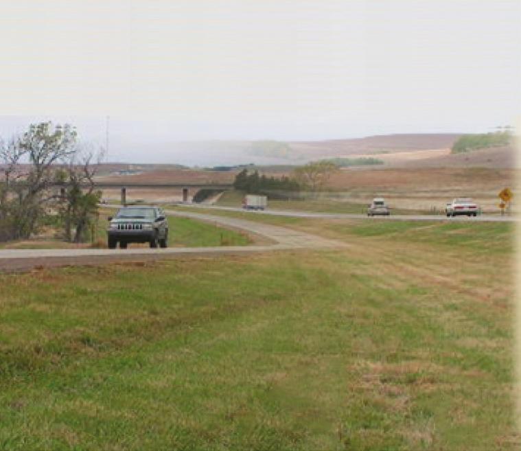
5 3. More than two-thirds of all roadway departure serious injuries and fatalities occur on rural roads and highways. Between 25 and 29, over 75 percent of roadway departure fatalities occurred on local roads and state highways in rural areas. This is slightly higher than the figure for all fatalities: 71 percent occurred in rural areas. During the same period, 68 percent of roadway departure disabling injuries, and 5 percent of all disabling injuries, occurred in rural areas. In sum, statistics show that roadway departure crashes on rural roads, compared with those on urban roads, are deadlier and more injurious. One contributing factor is obvious: Speed limits are higher on rural roads than most urban streets. Speeds are also higher on urban expressways and interstates, which account for nearly percent of roadway departure fatalities in urban areas. These numbers explain why the EAT will concentrate on strategies that address rural roads, urban expressways and interstates by Rural/Urban Location Rural Urban Seventy-five percent of roadway departure fatalities occur on rural roads. That figure is striking given the level of use of Kansas roads: In 29, the average daily vehicle-miles traveled on urban roads was about 1.2 million, on rural roads, about 39.6 million. Disabling Injuries Disabling Injuries by Rural/Urban Location Rural Urban The gap between rural and urban locations as contributors to roadway departure disabling injuries has been closing slightly in recent years. But the fact that two-thirds of the injuries occur in rural areas is significant given that urban areas are more heavily traveled.


6 . Rural Roadway Risks: High Speeds, Delays in Emergency Services Urban boundaries are developed collaboratively by KDOT and local governments every 1 years, coinciding with the taking of the census, and often include unincorporated areas on the edge of town. As the charts below reveal, more crashes, resulting in more deaths and injuries occur on rural roads than on urban roads. Rural crashes account for 71 percent of all fatal crashes, but just 58 percent of the crashes in which property, alone, is damaged. Of 1,69 miles of public roads in Kansas, 127, percent are rural. On the other hand, only 9 percent of all vehicles miles traveled in Kansas are on rural roads. If the number of vehicle miles traveled on rural and urban roads is nearly equal, why do rural roadways experience more fatal and serious injury crashes as a result of roadway departure than urban roadways? There are a number of contributing factors: Higher speeds: Less traffic and fewer intersections and driveways mean drivers are more comfortable traveling at a higher rate of speed. The posted speed limit reflects that reality. Discovery time: The length of time from when the crash occurred to when they are discovered and transported has an impact on the patient s survival. This is especially true for single-vehicle crashes. EMS: It takes longer for emergency vehicles in general and ambulances in particular to reach the crash scene and longer to deliver the injured to the nearest hospital or trauma center. Health care resources: Depending upon the severity of the injury, the patient s needs may exceed the capability of the rural health care facility. Engineering standards: Many of our rural local roads were designed and built long before modern safety standards by Functional Classification Minor collectors Interstate Local roads Minor arterials Major collectors Principal arterials Collectors City Streets Principal arterials Minor arterials Freeways & expressways Interstate VMT (in millions) Rural MVMT Urban The greater the separation between vehicle miles of travel (VMT) and fatalities, the lower the fatality rate. (Information on functional classifications can be found in Appendix C.) 5
 Rural Disabling Injuries Urban MVMT Urban disabling injuries")

7 Disabling Injuries Disabling Injuries by Functional Classification Minor collectors Interstate Minor arterials Principal arterials Local roads Major collectors Collectors Principal arterials Freeways & expressways City Streets Minor arterials Interstate VMT (in millions) Rural Disabling Injuries Urban MVMT Urban disabling injuries are almost three-and-a-half times higher than urban fatalities, while rural disabling injuries are about two times higher than rural fatalities. This suggests urban crashes may be more survivable than rural crashes. But, rural interstate disabling injuries are almost four times higher than rural interstate fatalities. This indicates rural interstate crashes also have a high rate of survival. Therefore, in the case of single-vehicle crashes, discovery, emergency response and delivery are possible contributing factors. 6


8 Performance Measures Consistent with this plan s overall goal, the EAT seeks to halve roadway departure fatalities and serious injuries within 2 years. In the five years between 25 and 29, we averaged 239 roadway-departure-related fatalities and 83 roadway-departure-related disabling injuries per year. Meeting our goal will require reducing the average fatalities per year to no more than 12, and the disabling injuries to at most 17, by the years 225 to 229. The figure below depicts this goal for fatalities in the difficult context in which it must be achieved a period of increased miles of vehicle travel in Kansas. KDOT planners project that between 25 and 29 and 225 and 229, Kansas will experience a 37 percent increase in vehicle miles traveled, making halving fatalities all the more challenging to achieve. Since 25, the roadway departure fatality rate has decreased by 9 percent. To reach our goal, we would need to decrease the rate by an additional 63 percent over the next 2 years. Fatality Rate v. Projected VMT 1. 5 Fatality Rate per million VMT VMT(in millions) Fatality Rate (five year average) VMT (in millions) One barrier to halving roadway-departure-related fatalities in Kansas over the next 2 years: forecasts of a substantial increase in vehicle miles traveled. 7


 Achieving this")
9 Interim goals will let us track our progress. The chart below shows our five-year goals. Our aim is to achieve 5 percent of our goal within five years, 75 percent within 1 years and percent within 2. We are optimistic that in the early years, the new primary seat belt law will reduce fatalities. v. Projected VMT VMT (in millions) (five year average) VMT (in millions) Achieving this goal would save about 1,629 lives over a twenty-year period. 8


10 Goals and Strategies Articulating our objective a radical reduction in the number of roadway departure crashes that kill or disable is only a start. What goals and strategies will help us accomplish that objective? The roadway departure EAT has chosen the following. 1. Dedicate safety dollars to data-driven programs with the greatest potential to reduce the number of fatal and severe injury crashes on Kansas public roads. 2. Use available traffic records, crash data and roadway data to assist in safety program and project management. 3. Promote proven engineering strategies that focus on keeping drivers on the road and in their lanes.. Promote mitigation strategies that lessen the consequences of a crash. 5. Introduce experimental engineering strategies. 6. Promote enforcement campaigns that target locations and corridors with a higher-than-expected number of roadway departure crashes. 7. Promote education campaigns that target over-represented factors in roadway departure crashes. There is no shortage of ideas about achieving these goals using a E approach: engineering centerline rumble strips and keeping the roadside clear of fixed objects, enforcing impaired driving and distracted driver laws, educating drivers and passengers about seat belt use and improving emergency medical service coordination to reduce the human cost of crashes, for example. The challenge for the roadway departure team is to identify realistic strategies, prioritize them and seek implementation. Goal 1: Dedicate safety dollars to data-driven programs with the greatest potential to reduce the number of fatal and severe injury crashes on Kansas public roads. Current Strategies: Maintain sign retro-reflectivity (visibility when lighted by headlights) on state highways by replacing sign sheeting at scheduled intervals based on anticipated service life. Maintain pavement marking retro-reflectivity on state highways with a program that selects routes for maintenance based on the routine collection of retro-reflectivity data. 9
11 New Strategy: Recommend new distribution of Highway Safety Improvement Program, or HSIP, funding based on Kansas crash statistics. (This is a strategy jointly recommended by the roadway departure and intersections EATs.) Background: HSIP is a federal-aid safety program, established under SAFETEA-LU in federal fiscal year 26, to achieve a significant reduction in traffic fatalities and serious injuries on all public roads. In 211, Kansas received $28. million, which was distributed to the following safety programs: Highway-Railway Grade Crossing and Rail Set-aside (2 percent) Intersection Safety (2 percent) Pavement Marking Set-aside (15 percent) Lighting Set-aside (7 percent) Signing Set-aside (6 percent) High Risk Rural Roads (6 percent) Some of this distribution is determined by SAFETEA-LU, but most of it results from KDOT practice. The purpose of this strategy is to reallocate the money based on the goals articulated in this document. KDOT will form a working group to review the history of fund distribution, review data and make recommendations. The working group will also explore ways to streamline federal and state spending by local jurisdictions. Method: policy Costs: minimal Lead agency and contact: KDOT, Traffic Engineering Section Challenges: changing existing programs and practices Target date: begin implementation following federal reauthorization of the HSIP program 1
12 Goal 2: Use available traffic records, crash data and roadway data to assist in safety program and project management. New Strategy: Identify and analyze outstanding variables related to crashes that occur away from intersections and don t involve animals, based on the Kansas 21 Five Percent Report. (See Data Support chapter for action plan.) DECATUR BROWN DONIPHAN NORTON CHEYENNE REPUBLIC RAWLINS 9 PHILLIPS 25 9 SMITH JEWELL 1 CLOUD WASHINGTON MARSHALL NEMAHA 9 ATCHINSON THOMAS RILEY POTTAWATOMIE JACKSON JEFFERSON 92 MITCHELL LEAVENWORTH SHERMAN SHERIDAN GRAHAM ROOKS OSBORNE OTTAWA WYANDOTTE CLAY WABAUNSEE SHAWNEE LINCOLN GEARY 335 DOUGLAS JOHNSON WALLACE LOGAN GOVE ELLIS TREGO RUSSELL SALINE DICKINSON MORRIS 35 ELLSWORTH MARION OSAGE FRANKLIN 35 MIAMI RUSH 31 GREELEY WICHITA SCOTT LANE NESS COFFEY BARTON PAWNEE RICE MCPHERSON ANDERSON LYON LINN FINNEY CHASE HODGEMAN HARVEY STAFFORD 135 HAMILTON 177 KEARNY WOODSON ALLEN BOURBON EDWARDS RENO GREENWOOD HASKELL 2 15 FORD STANTON 81 7 GRAY KINGMAN PRATT SEDGWICK BUTLER ELK 99 CRAWFORD GRANT KIOWA WILSON 169 NEOSHO 126 COWLEY MORTON MONTGOMERY 5 LABETTE CHAUTAUQUA SEWARD SUMNER STEVENS MEADE CHEROKEE CLARK COMANCHE BARBER HARPER 15 Combined 5 % A A 26, 28, 27 5% Reports that Overlap GIS_CNTY_NAME GIS_SHIELD_NUM GIS_K_ROUTES GIS_US_SHIELDS STATE_SYSTEM Combined 5 Percent High Accidents GIS_INTERSTATE_SHIELDS GIS_COUNTY Future Strategy: Develop a process to account for recommendations from traffic studies (such as road safety assessments and Traffic Engineering Assistance Program studies) to generate projects within existing safety programs and contribute to new and future projects in other programs. 11


 1 12 8 6 2 Disabling Injuries Adverse surface")
13 Goal 3: Promote proven engineering strategies that focus on keeping drivers on the road and in their lanes. Current Strategies: Maintain 6-inch-wide edge lines on state highways. Improve shoulders where reasonable. Install shoulder rumble strips where appropriate. Revitalize KDOT s Wet Pavement Accident Reduction Team. Disabling Injuries Contribution of Adverse Surface Conditions to (25-29) Disabling Injuries Adverse surface conditions are noted as a factor in about 15 to 2 percent of all crashes, depending on the year. Before After 12

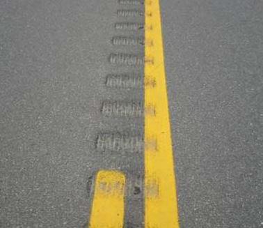
14 New Strategies: Research the potential impact of expanded use of centerline rumble strips Background: The FHWA has designated centerline rumble strips, or CLRS, as one of its Nine Proven Countermeasures to reduce highway fatalities. CLRS target head-on crashes and sideswipes involving multiple vehicles. In 27, KDOT established a policy on milled-in CLRS, allowing their use on two-lane rural highways with a shoulder width of at least three feet. Since 27, KDOT has installed over 3 miles of CLRS, with more than 3, miles of state highways eligible based on the policy. If we eliminate the minimum shoulder width criterion additional state highway miles will be eligible. How many local roads utilize CLRS is unknown. An unresolved question remains, however: do drivers shy away from CLRS and increase their odds of running off the right side of the road? 12 Involving Multiple Vehicles (25-29) Total Crashes Fatal Crashes Head on Sideswipe: opposite direction Sideswipe: same direction Total Crashes Fatal Crashes Roadway departure events involving two or more vehicles are most commonly the result of same-direction sideswipes, but head-on collisions result in the highest number of fatalities. Method: research and policy Costs: $6, Performance measure: reduction in head-on crashes on road types added under an expanded policy Lead agency and contact: KDOT, Highway Safety Unit Challenges: well-designed research that validates expansion of policy and additional project costs Target date: final research report in state fiscal year

15 Create a program that funds the deployment of low-cost safety improvements at rural or high speed urban horizontal curves. Background: It s estimated that in the Kansas state highway system, there are about 1, miles of curves a tenth of the total roadway mileage. But about 17 percent of fatal crashes happen on horizontal curves. This program will take into account proven and experimental countermeasures to prevent crashes on rural horizontal curves and on urban high-speed curves. These would include, for example, adding high-friction materials to road surfaces and improving delineation (a term that refers to methods used by highway engineers to define roadway operating areas for drivers). by Road Character Type (25-29) Disabling Injuries Straight and level 257 Straight on grade/slope 39 Straight on hillcrest 139 Curved and level 116 Curved on grade/slope Curved on hillcrest Other Unknown Disabling Injuries The contribution of curves and hills to injury and fatality statistics exceeds the proportion of the entire Kansas road system they represent. Method: program Costs: $25, annually (estimated) Performance measures: number of curves treated and consequent reduction in crashes Lead agency and contact: KDOT, Highway Safety Unit Challenges: funding a new program and identifying curves where treatment would be likely to produce the best results Target date: begin letting projects in state fiscal year 213. Explore expanded use of edgeline rumble stripes. Background: In 27, KDOT established a new policy for the use of centerline rumble strips and revised its policy on the use of shoulder rumble strips. Both edgeline rumble stripes, or ELRS, and shoulder rumble strips alert drivers when they drift off the road. The difference is that for ELRS the white edgeline is placed right over the top of the rumble strip while shoulder rumble strips are sited farther right, on the shoulder. Potential advantages to ELRS are improved visibility of the edgeline in wet weather, use on twolane roads that lack shoulders and use on two-lane roads with narrow shoulders. An added benefit to using ELRS on two-lane roads with narrow shoulders is that ELRS 1
 Lead agency and contact: KDOT, Highway Safety Unit Challenges: finding road segments for experimentation; policy changes that will raise project")
16 accommodate bicyclists. But few demonstration projects using edgeline rumble stripes have been completed in Kansas. Method: research and policy Costs: $6, (estimated) Lead agency and contact: KDOT, Highway Safety Unit Challenges: finding road segments for experimentation; policy changes that will raise project costs Target date: policy change, where appropriate, by July 213 Future Strategy: Promote wider edgeline pavement markings on local roads. Experiment with the Safety Edge. 15

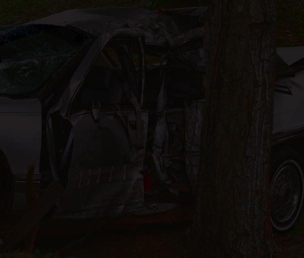
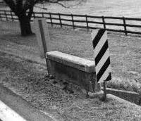
17 Goal : Promote strategies that mitigate the consequences of a crash. Current strategy: Continue application of the most current Roadside Design Guide in highway design. The guide is a document that highway agencies commonly use to develop standards and policies. New strategy: Create a program that funds the removal of fixed objects. Background: In a fixed-object crash, a vehicle leaves its lane and runs into a ditch, an object (a light pole or tree, for example) or a barrier (such as a guardrail). Analyzing the types of objects struck, and at what frequency, might suggest targeted countermeasures or policy changes in fixed object placements. Total Crashes Fixed Objects Struck in Crashes (25-29) Total Crashes Objects mostly likely to be hit when drivers leave the road include ditches, utility devices (such as a telephone pole) and median barriers. However, striking a tree results in the highest number of fatality crashes. Some objects are engineered and positioned in the roadside environment with driver survival in mind (median barriers and guardrails, for example) while others (like trees) are not. Method: program Costs: $25, annually (estimated) Performance measure: reduced numbers of crashes involving objects targeted by the program Lead agency and contact: KDOT, Bureau of Local Projects Challenges: funding a new program, partnering with local agencies to identify fixed objects, addressing environmental sensitivities to tree removal Target date: begin letting projects in federal fiscal year


18 Goal 5: Promote enforcement campaigns that target locations and corridors with a higher than expected number of roadway departure crashes. Current strategies: Support implementation and expansion of the primary seat belt law. Select stretches of road for targeted enforcement efforts. Future strategy: Develop and implement a Safety Corridor Program. Background: Several states have developed successful safety corridor programs. This approach begins by identifying highway corridors with safety issues, including but not limited to high crash frequencies or rates, then using a E approach to identify treatments and strategies to improve corridor safety. 17


19 Goal 6: Promote education campaigns that alert the public to the most frequent causes of roadway departure crashes. Current strategies: Continue media campaigns highlighting the danger of impaired or distracted driving. Promote educational campaigns to let people know the likelihood of unbelted drivers and passengers being thrown from a vehicle in a rollover and their survival rate. Provide training and educational materials to public works departments and other local agencies through the Local Transportation Assistance Program, or LTAP, at the University of Kansas and the Traffic Assistance Services for Kansas, or TASK, program at Kansas State University. Promote defensive driving training. New strategy: Conduct road safety assessments on local roads under the umbrella of the High Risk Rural Roads Program. Background: The High Risk Rural Roads Program is a federal safety program for locally owned rural roads. Of the 1, miles of public roads in Kansas, about 13, are under the jurisdiction of cities, counties and townships. Ownership, however, is not the issue: The users of all public roads benefit from a road safety assessment, or RSA. According to the FHWA, an RSA is a formal safety performance examination of an existing or future road or intersection by an independent and multi-disciplinary team. It estimates and reports on potential road safety issues and identifies opportunities for improvements in safety for all road users. All Local Roadway Departure Crashes Fatal and Serious Injury Local Roadway Departure Crashes Urban 51% Rural 9% Urban 29% Rural 71% On local roads, roadway departure crashes are evenly split between urban and rural settings. But rural roadway departure crashes tend to be more severe. 18


20 Method: program Costs: minimal Performance measures: number of RSAs completed Lead agency and contact: KDOT, Bureau of Local Projects Challenges: finding and training volunteers to serve on teams, promoting local participation. Target date: immediate Future strategy: Raise public awareness of more and less safe times to drive. Time Trends for Crashes (25-29) Fatal Crashes Total Crashes 6 1 Total Crashes Fatal Crashes Total number of roadway departure crashes generally trends with traffic patterns throughout the day, and severity follows, especially between a.m. and 9 p.m. At night however, particularly between 9 p.m. and a.m., the total crash rate increases significantly (less traffic, similar number of crashes) with a greater share of these severe or fatal. 19
ANNUAL BUSINESS FORMATION REPORT January 11, 2013
 ANNUAL BUSINESS FORMATION REPORT January 11, 2013 When I became Kansas Secretary of State in January of 2011, one of my first goals was to charge my staff with analyzing the applicable laws and policies
FOR RELEASE: WEDNESDAY, OCTOBER 8 AT 4 PM
 Kansas In Kansas, interviews with 1,025 adult Americans conducted by telephone by ORC International on October 2-6, 2014. The margin of sampling error for results based on the total sample is plus or minus
Estimated 2014 ARC-CO Wheat Payments Kansas and Oklahoma 1
 Disclaimer: This web page is designed to aid farmers with their marketing and risk management decisions. The risk of loss in trading futures, options, forward contracts, and hedge-to-arrive can be substantial
DATE TIME TROOP LOCATION TYPE NOTES 1/1/ E U-53, Haskell/Seward Counties Saturation Patrol 1/3/ E Finney County
 DATE TIME TROOP LOCATION TYPE NOTES 1/1/2017 1900-2200 E U-53, Haskell/Seward Counties Saturation Patrol 1/3/2017 1300-1500 E Finney County Saturation Patrol 1/5/2017 0700-0900 F U-160, Sumner County Speed
A Strategic Highway Safety Plan. a coordinated and informed approach to reducing highway fatalities and serious injuries on all public roads.
 Introduction A Strategic Highway Safety Plan is a coordinated and informed approach to reducing highway fatalities and serious injuries on all public roads. A Strategic Highway Safety Plan is Based on
DECEMBER 2007 SIGNIFICANT FACTS AND TRENDS
 KANSAS DEPARTMENT OF TRANSPORTATION BUREAU OF TRANSPORTATION PLANNING DECEMBER 0 SIGNIFICANT FACTS AND TRENDS DEPARTMENTOF DEPARTMENTOFTRANSPORTATION TRANSPORTATION KA N SAS Contact the Traffic and Field
KANSAS DEPARTM ENT OF TRANSPORTATION BUREAU OF TRANSPORTATION PLANNING JANUARY 2017 SIGNIFICANT FACTS AND TRENDS
 KANSAS DEPARTM ENT OF TRANSPORTATION BUREAU OF TRANSPORTATION PLANNING JANUARY 17 SIGNIFICANT FACTS AND TRENDS Month Jan Feb Mar Apr May Jun Jul Aug Sep Oct Nov Dec Average Travel on the Kansas State Highway
Roadside Safety Proven Countermeasures. Emmett McDevitt Transportation Safety Engineer Federal Highway Administration
 Roadside Safety Proven Countermeasures Emmett McDevitt Transportation Safety Engineer Federal Highway Administration Safety Statistics On average each year 43,000 + people die in traffic related crashes.
KANSAS DEPARTM ENT OF TRANSPORTATION BUREAU OF TRANSPORTATION PLANNING NOVEM BER 2018 SIGNIFICANT FACTS AND TRENDS
 KANSAS DEPARTM ENT OF TRANSPORTATION BUREAU OF TRANSPORTATION PLANNING NOVEM BER 018 SIGNIFICANT FACTS AND TRENDS Month Jan Feb Mar Apr May Jun Jul Aug Sep Oct Nov Dec Average Travel on the Kansas State
Kansas Department of Transportation Strategic Highway Safety Plan. Intersections
 Kansas Department of Transportation Strategic Highway Safety Plan Intersections Introduction The Federal Highway Administration (FHWA) defines an intersection as a planned point of conflict in the roadway
KANSAS DEPARTM ENT OF TRANSPORTATION BUREAU OF TRANSPORTATION PLANNING DECEM BER 2018 SIGNIFICANT FACTS AND TRENDS
 KANSAS DEPARTM ENT OF TRANSPORTATION BUREAU OF TRANSPORTATION PLANNING DECEM BER SIGNIFICANT FACTS AND TRENDS Month Jan Feb Mar Apr May Jun Jul Aug Sep Oct Nov Dec Average Travel on the Kansas State Highway
2009 KANSAS TRAFFIC ACCIDENT FACTS BOOK
 2009 KANSAS TRAFFIC ACCIDENT FACTS BOOK Kathleen Sebelius, Governor Deb Miller, Secretary of Transportation Quick Facts Traffic 348 Fatal 13,925 Injury 46,900 Property-Damage-Only 61,173 All Persons Involved
JUNE 2007 SIGNIFICANT FACTS AND TRENDS
 KANSAS DEPARTMENT OF TRANSPORTATION BUREAU OF TRANSPORTATION PLANNING JUNE 07 SIGNIFICANT FACTS AND TRENDS Travel on the Kansas State Highway System Daily Vehicle Miles % Change (In Millions) 06 to 07
Chapter 3. Roads, Streets and Highways Condition and Needs
 Chapter 3 Roads, Streets and Highways Condition and Needs Roads, Streets, and Highways - Conditions and Needs With 13, miles of public roads, Kansas ranks fourth among the states in number of public road
OFFICE OF THE KANSAS SECRETARY OF STATE 2018 General Election Advance Voting Times & Locations
 OFFICE OF THE KANSAS SECRETARY OF STATE 2018 General Election Advance Voting Times & Locations ALLEN COUNTY Allen County Clerk s Office 1 N Washington Iola, Kansas 66749 October 17-19, 2018 from 7:45 AM
OFFICE OF THE KANSAS SECRETARY OF STATE 2016 PRIMARY ADVANCE VOTING SITES
 OFFICE OF THE KANSAS SECRETARY OF STATE 2016 PRIMARY ADVANCE VOTING SITES ALLEN COUNTY Allen County Courthouse, 1 N. Washington, Iola, KS 66749 o Hours: Monday Friday 7:30 AM- 5:00 PM ANDERSON COUNTY Anderson
APPENDIX G Lane Departure Action Plan
 APPENDIX G Introduction Lane Departure is one of nine emphasis areas of the North Carolina Strategic Highway Safety Plan. This emphasis area targets the following crashes: Ran Off Road Left Ran Off Road
What Engineering Can Do for You! Low Cost Countermeasures for Transportation Safety
 What Engineering Can Do for You! Low Cost Countermeasures for Transportation Safety Adam Larsen Safety Engineer Federal Highway Administration 360-619-7751 Adam.Larsen@DOT.GOV Adam Larsen TTP Safety Engineer
Dear Fellow Nebraskans:
 Dear Fellow Nebraskans: In accordance with the provisions in the Safe, Accountable, Flexible, and Efficient Transportation Equity Act A Legacy for Users (SAFETEA LU), each state is required to develop
Implementing Strategies from Missouri s Blueprint for Safer Roadways Using System-wide Safety Solutions to Save Lives
 Implementing Strategies from Missouri s Blueprint for Safer Roadways Using System-wide Safety Solutions to Save Lives John Schaefer Sr. Traffic Studies Specialist Missouri Department of Transportation
Fatal Head-On Crashes on. Rural Two-Lane Two-Way Highways in Minnesota
 Fatal Head-On on Rural Two-Lane Two-Way Highways in Minnesota A Report Submitted to the Minnesota Department of Transportation By Derek Leuer, PE Office of Traffic, Safety, and Technology Minnesota Department
Local Road Safety Plans
 An Introduction to Local Road Safety Plans June 21, 2018 Today s Presenter Jerry Roche, P.E. Safety Analysis Program Manager FHWA Office of Safety Ames, IA 2 NACE Do-It-Yourself LRSP Pilot Six states,
Kansas Active Livescans
 Kansas Active Livescans County Agency City LS Company Installation Date Status Allen Allen County Sheriff Iola CROSSMATCH 12/10/2004 Act Atchison Atchison County Sheriff Atchison CROSSMATCH 12/15/2005
HSIP Project Selection Criteria
 HSIP Project Selection Criteria The purpose of the Highway Safety Improvement Program (HSIP) is to reduce the number of fatal and injury crashes by targeting high crash locations and causes. Projects,
Closing Plenary Session
 TRAFFIC SAFETY CONFERENCE Closing Plenary Session June 9, 2017 Las Colinas, TX Order of Report Out June 9, 2017 Las Colinas, TX Distracted Driving Prioritized Countermeasures Countermeasure 4a Systemically
Table of Contents Kansas Highway Safety Improvement Program
 KANSAS Page 1 of 54 Table of Contents Table of Contents... 2 Disclaimer... 3 Executive Summary... 4 Introduction... 5 Program Structure... 5 Program Administration... 5 Program Methodology... 8 Project
Acknowledgements. Mr. David Nicol 3/23/2012. Daniel Camacho, P.E. Highway Engineer Federal Highway Administration Puerto Rico Division
 Daniel Camacho, P.E. Highway Engineer Federal Highway Administration Puerto Rico Division Acknowledgements Mr. David Nicol Director, FHWA Office of Safety FHWA Office of Safety http://safety.fhwa.dot.gov/provencountermeasures/
Toward Zero Deaths. Regional SHSP Road Show Meeting. Virginia Strategic Highway Safety Plan. presented by
 Toward Zero Deaths Regional SHSP Road Show Meeting presented by Virginia Strategic Highway Safety Plan December 1, 2016 1 Welcome & Introductions Purpose of the Meeting Objectives & Key Outcomes Agenda»
Occ c u c pa p n a t pro r t O ec e t c i t O i n
 Occupant Protection Occupant Protection Introduction Buckling up or being buckled in is the most effective protection during a car crash. The simple truth is that the great majority of people ejected from
Engineering Countermeasures for Transportation Safety. Adam Larsen Safety Engineer Federal Highway Administration
 Engineering Countermeasures for Transportation Safety Adam Larsen Safety Engineer Federal Highway Administration 360-619-7751 Adam.Larsen@DOT.GOV Countermeasure Selection Resources Manual for Selecting
Michael D. Turpeau Jr. State Safety Program Supervisor Georgia Department of Transportation
 Michael D. Turpeau Jr. State Safety Program Supervisor Georgia Department of Transportation Safety Programs Highway Safety Improvement Program (HSIP) Off-System Safety Program (OSSP) High Risk Rural Roads
Sponsored by the Office of Traffic and Safety of the Iowa Department of Transportation NOVEMBER 2001 CTRE
 PAVED SHOULDERS ON PRIMARY HIGHWAYS IN IOWA: AN ANALYSIS OF SHOULDER SURFACING CRITERIA, COSTS, AND BENEFITS EXECUTIVE SUMMARY Sponsored by the Office of Traffic and Safety of the Iowa Department of Transportation
Lane Departure. Key Facts
 Crash Certain types of vehicle crashes are more dangerous to drivers and other road users. The data show that crashes that involve lane departure and intersections are particularly perilous. Meanwhile,
Systemic Safety. Doug Bish Traffic Services Engineer Oregon Department of Transportation March 2016
 Systemic Safety Doug Bish Traffic Services Engineer Oregon Department of Transportation March 2016 Oregon averages 1700 fatal and serious injury crashes each year. Some of the more common crash types include:
Road Safety Assessments. Lt. Bob McCurdy Williamson County Sheriff s s Office Marion, IL.
 Road Safety Assessments Lt. Bob McCurdy Williamson County Sheriff s s Office Marion, IL. Why Are We Here? 2005 US Traffic Fatalities = 43,443 1429 4329 1361 1616 1534 3504 1729 3543 Illinois Annual Fatallities
Pavement Markings (1 of 3)
") Pavement Markings (1 of 3) DESCRIPTION AND DEFINITION Disadvantages Relatively high cost (over typical Crash reduction as yet unknown painted edge line) No tactile effect The STOP AHEAD pavement marking
Pavement Markings (1 of 3) DESCRIPTION AND DEFINITION Disadvantages Relatively high cost (over typical Crash reduction as yet unknown painted edge line) No tactile effect The STOP AHEAD pavement marking
PRELIMINARY DRAFT FIRST AMENDMENT TO VISION 2050: A REGIONAL LAND USE AND TRANSPORTATION PLAN FOR SOUTHEASTERN WISCONSIN
 PRELIMINARY DRAFT FIRST AMENDMENT TO VISION 2050: A REGIONAL LAND USE AND TRANSPORTATION PLAN FOR SOUTHEASTERN WISCONSIN ESTABLISHING TARGETS FOR FEDERAL PERFORMANCE MEASURES: HIGHWAY SAFETY SOUTHEASTERN
Lessons Learned from the Minnesota County Road Safety Plans. Richard Storm CH2M HILL
 Lessons Learned from the Minnesota County Road Safety Plans Richard Storm CH2M HILL May 21, 2014 Overview of the MN CRSP: Why Prepare Safety Plans for Local Systems? MAP-21: Requires states to address
road safety issues 2001 road toll for Gisborne district July 2002 Road user casualties Estimated social cost of crashes*
 GISBORNE DISTRICT road safety issues July 22 The Land Transport Safety Authority (LTSA) has prepared this Road Safety Issues Report. It is based on reported crash data and trends for the 1997 21 period.
Table of Contents. Introduction Day Survey Participants...3
 August 2, 27 Table of Contents Introduction...................... 3-Day Survey Participants..............3 State Regions Map.................. 4 Survey Results by Region: KC Metro.........................
Road Safety Audit Course Participant Guidebook. August 22 & 23, Cleveland Avenue Columbus, Ohio
 Road Safety Audit Course Participant Guidebook August 22 & 23, 2017 Cleveland Avenue Columbus, Ohio 1 2 Table of Contents Executive Summary... 5 Cleveland Avenue City of Columbus... 6 Road Location Details...
Kansas. Spring Turkey. Hunting Atlas. Spring Turkey. Seasons. Includes Walk-In Hunting Access (WIHA) areas and public lands (state and federal)
 areas and public lands (state and federal)") 20 Kansas Spring Turkey Hunting Atlas Spring Turkey Seasons YOUTH/DISABILITY April 1-1, 20 ARCHERY April -1, 20 REGULAR April - May, 20 ksoutdoors.com Includes Walk-In Hunting Access (WIHA) areas and public
20 Kansas Spring Turkey Hunting Atlas Spring Turkey Seasons YOUTH/DISABILITY April 1-1, 20 ARCHERY April -1, 20 REGULAR April - May, 20 ksoutdoors.com Includes Walk-In Hunting Access (WIHA) areas and public
Olmsted County Highway Safety Plan
 TB072009008MKE Olmsted County Highway Safety Plan September 2009 Submitted to: Table of Contents 1. Introduction...1-1 2. Comprehensive Crash Analysis...2-1 3. Safety Emphasis Areas...3-1 4. Safety Strategies...4-1
DRIVING ZERO FATALITIES TO A REALITY ILLINOIS LOCAL SAFETY INITIATIVE
 DRIVING ZERO FATALITIES TO A REALITY ILLINOIS LOCAL SAFETY INITIATIVE Priscilla Tobias, PE State Safety Engineer Illinois Dept of Transportation Illinois Stats 102 Counties 145,000 Roadway Miles 900+ Fatalities
Guardrail and Bridge Rail Recommendations for Very Low-Volume Local Roads in Kansas
 Report No. KS-14-16 FINAL REPORT December 2014 Guardrail and Bridge Rail Recommendations for Very Low-Volume Local Roads in Kansas Ronald J. Seitz, P.E. Tod Salfrank Kansas Department of Transportation
Safety Data Resources. Multi-Discipline Safety Planning Forum March 10 & 11, 2008 Gateway Center
 Safety Data Resources Multi-Discipline Safety Planning Forum March 10 & 11, 2008 Gateway Center Tom McDonald, PE Safety Circuit Rider Iowa LTAP Jack Latterell,, PE Safety Consultant FHWA Safety Engineer,
Designing for Pedestrians: An Engineering Symposium. Rutgers University March 21, 2013
 Designing for Pedestrians: An Engineering Symposium Rutgers University March 21, 2013 The Problem 2 Pedestrian Fatalities Pedestrian Fatalities by Year in US (1994-2010) 6000 5000 4000 3000 2000 1000 0
Maine Highway Safety Facts 2016
 Maine Highway Safety Facts 216 216 MAINE HIGHWAY SAFETY FACTS The Bureau of Highway Safety and the Maine Department of Transportation are pleased to present the 216 edition of Maine Highway Safety Facts.
APPENDIX C. Systems Performance Report C-1
 APPENDIX C Systems Performance Report C-1 System Performance Report & Requirements According to the FAST Act, a long range transportation plan needs to include a system performance report and subsequent
Recently Developed Intersection CMFs. Nancy Lefler, VHB ATSIP Traffic Records Forum, 2014
 Recently Developed Intersection CMFs Nancy Lefler, VHB ATSIP Traffic Records Forum, 2014 Overview General Methodology Treatments Installation of traffic signals - with and without left-turn lanes (NCDOT)
6.8 Transportation Safety & Security
 6.8 Transportation Safety & Security This chapter addresses transportation safety and security as required under MAP-21 and California s Strategic Highway Safety Plan. Transportation safety and security
Local Rural Road Safety
 Local Rural Road Safety County State Aid Highway (CSAH) 5 Freeborn County, Minnesota National Surface Transportation Policy & Revenue Study Commission Testimony submitted by: Susan G. Miller, P.E. County
KANSAS STRATEGIC HIGHWAY SAFETY PLAN
 KANSAS STRATEGIC HIGHWAY SAFETY PLAN 214 Annual Dashboard Report Preliminary Statewide Fatality Analysis The accident data herein, as of February 19, 215, reflect the reporting officer s observations and
TEXAS TRAFFIC SAFETY TASK FORCE. Jeff Moseley Texas Transportation Commission
 TEXAS TRAFFIC SAFETY TASK FORCE Jeff Moseley Texas Transportation Commission June 7, 2016 Fatalities and fatal crashes 2010 2015 4,000 3,500 3,417 3,407 3,536 3,533 3,000 3,061 3,067 2,782 2,803 3,037
November 2, Government takes on the challenge of improving traffic safety
 November 2, 2006 Government takes on the challenge of improving traffic safety Edmonton... The Alberta government has taken on the challenge of improving traffic safety by moving ahead with a comprehensive,
Institute of Transportation Engineers Safety Action Plan
 I Institute of Transportation Engineers Safety Action Plan 1. Introduction 2. Intersection Crashes 3. Keep Vehicles on the Road 4. Minimize Consequences When Vehicles Leave the Road 5. School Crossing
KANSAS STRATEGIC HIGHWAY SAFETY PLAN (SHSP) The stakeholder group identified the following direction for the SHSP:
 The stakeholder group identified the following direction for the SHSP:") KANSAS STRATEGIC HIGHWAY SAFETY PLAN (SHSP) Executive Summary On February 2-3, 2006, the Kansas Department of Transportation hosted a safety summit to initiate the development of the Kansas Strategic Highway
KANSAS STRATEGIC HIGHWAY SAFETY PLAN (SHSP) Executive Summary On February 2-3, 2006, the Kansas Department of Transportation hosted a safety summit to initiate the development of the Kansas Strategic Highway
Technical Memorandum SAFETY AND SECURITY. Prepared for: Prepared by:
 Technical Memorandum SAFETY AND SECURITY Prepared for: Prepared by: June 2013 TABLE OF CONTENTS 1. Introduction... 1 1.1 Background... 1 1.2 SAFETEA-LU... 1 1.3 MAP-21... 2 1.3.1 Highway Safety Improvement
Now Let s Think Systemic
 Now Let s Think Systemic Remote Rural County Use of the Highway Safety Improvement Program TRINITY COUNTY DEPARTMENT OF TRANSPORTATION Richard Tippett Director MEET TRINITY COUNTY 3,208 square miles 13,786
Keep Customers and Ourselves Safe. Mark Shelton, District Engineer. Tracker. Measures of Departmental Performance
 Keep Customers and Ourselves Safe Mark Shelton, District Engineer Tracker Measures of Departmental Performance Safety is a daily commitment for all MoDOT employees. From design and construction to operations
Speed Management Action Plan
 Speed Management Action Plan National Selection Criteria Criteria Description Fatalities The number of fatalities resulting from speeding-related crashes. Percentage Compares total fatalities in each State
City of Wayzata Comprehensive Plan 2030 Transportation Chapter: Appendix A
 A1. Functional Classification Table A-1 illustrates the Metropolitan Council s detailed criteria established for the functional classification of roadways within the Twin Cities Metropolitan Area. Table
Access requests to County streets and roadways are processed through one of the following methods:
 13.1 GENERAL APPLICATION PROCESS Access requests to County streets and roadways are processed through one of the following methods: A. Planned Developments may set general locations for access points.
South Carolina s Strategic Highway Safety Plan
 Target Zero South Carolina s Strategic Highway Safety Plan 215-218 March 4, 215 Dear Highway Safety Partner: The South Carolina Department of Public Safety (SCDPS) and the South Carolina Department of
Truck Climbing Lane Traffic Justification Report
 ROUTE 7 (HARRY BYRD HIGHWAY) WESTBOUND FROM WEST MARKET STREET TO ROUTE 9 (CHARLES TOWN PIKE) Truck Climbing Lane Traffic Justification Report Project No. 6007-053-133, P 101 Ι UPC No. 58599 Prepared by:
Driveway Design Criteria
 Design Manual Chapter 5 - Roadway Design 5L - Access Management 5L-4 Driveway Design Criteria A. General For efficient and safe operations, access drives and minor public street intersections can be improved
M-58 HIGHWAY ACCESS MANAGEMENT STUDY Mullen Road to Bel-Ray Boulevard. Prepared for CITY OF BELTON. May 2016
 M-58 HIGHWAY ACCESS MANAGEMENT STUDY Prepared for CITY OF BELTON By May 2016 Introduction Missouri State Highway 58 (M-58 Highway) is a major commercial corridor in the City of Belton. As development has
Where Did the Road Go? The Straight and Narrow about Curves
 Where Did the Road Go? The Straight and Narrow about Curves Renae Kuehl, SRF Consulting Group October 23, 2018 What is a County Roadway Safety Plan or CRSP?" CRSP Identifies priority location-specific
Department of Transportation
 Department of Transportation I. Internal Scan The number of older drivers in the United States will double over the next 30 years. By 2030 one in five Americans will be age 65 or older. On a licensed-driver
Bicycle - Motor Vehicle Collisions on Controlled Access Highways in Arizona
 Bicycle - Motor Vehicle Collisions on Controlled Access Highways in Arizona Analysis from January 1, 1991 to June 30, 2002 Richard C. Moeur, PE Traffic Design Manager, Northern Region Michelle N. Bina
Highway Safety Improvement
 Highway Safety Improvement Tracy Turpin, PE. Highway Safety Improvement Program Manager Virginia Department of Transportation Presented at Chesapeake and Virginia Chapters of ATSSA Meeting October 13 th,2016
Education Emergency Medical Services Enforcement Engineering. north dakota strategic highway safety plan. Submitted by
 Education Emergency Medical Services Enforcement Engineering north dakota strategic highway safety plan Submitted by SEPTEMBER 2013 North Dakota Strategic Highway Safety Plan Prepared for North Dakota
2003 road trauma for. Wairoa District. Road casualties Estimated social cost of crashes* Major road safety issues WAIROA DISTRICT JULY 2004
 WAIROA DISTRICT JULY 24 T he Land Transport Safety Authority (LTSA) has prepared this road safety issues report. It is based on reported crash data and trends for the 1999 23 period. The intent of the
1 Monash University Accident Research Centre, Monash University, Victoria, RACV, 550 Princes Highway Noble Park, Victoria, 3174.
 Roadside Environment Safety: a statistical analysis of collisions with fixed roadside objects in Victoria Amanda Delaney 1, Stuart Newstead 1, Bruce Corben 1, Jim Langford 1 and Peter Daly 2 1 Monash University
Road Safety Audit Report: Interstate 516
 Road Safety Audit Report: Interstate 516 Interstate 516 from Veterans Pkwy to Montgomery St. (State Route 420 from Veterans Pkwy to City Street 115207) Table of Contents Introduction Road Safety Audit
Hot Spot Identification and Analysis Methodology
 Brigham Young University BYU ScholarsArchive All Theses and Dissertations 2013-11-20 Hot Spot Identification and Analysis Methodology Jacob S. Farnsworth Brigham Young University - Provo Follow this and
CTDOT Pedestrian and Bicycle Safety Initiatives
 CTDOT Pedestrian and Bicycle Safety Initiatives 2017 Northeast Transportation Safety Conference Mark F. Carlino, P.E. Traffic Engineering Division Chief Bureau of Engineering and Construction Connecticut
State of Kansas. Highway Safety Plan FFY Sam Brownback, Governor. Mike King, Secretary, Kansas Department of Transportation
 State of Kansas Highway Safety Plan FFY 2014 Sam Brownback, Governor Mike King, Secretary, Kansas Department of Transportation Chris Herrick, Director, KDOT Division of Planning and Development Mike Floberg,
5. RUNNINGWAY GUIDELINES
 5. RUNNINGWAY GUIDELINES These guidelines should be considered collectively when making runningway decisions. A runningway is the linear component of the transit system that forms the right-of-way reserved
Functional Classification of Roads and Streets
 Functional Classification of Roads and Streets J o h n E. B a e r w a ld Professor of Transportation and Traffic Engineering Director, Highway Traffic Safety Center University of Illinois, Urbana-Champaign
Characteristics of Traffic Accidents in Highway Work Zones
 Characteristics of Traffic Accidents in Highway Work Zones A DETAILED ANALYSIS OF WORK ZONE ACCIDENTS REPORTED ON NEW YORK STATE DEPARTMENT OF TRANSPORTATION CONSTRUCTION PROJECTS ESTABLISHED THE PREDOMINANT
RURAL HIGHWAY SHOULDERS THAT ACCOMMODATE BICYCLE AND PEDESTRIAN USE (TxDOT Project ) June 7, Presented by: Karen Dixon, Ph.D., P.E.
 June 7, Presented by: Karen Dixon, Ph.D., P.E.") RURAL HIGHWAY SHOULDERS THAT ACCOMMODATE BICYCLE AND PEDESTRIAN USE (TxDOT Project 0-6840) June 7, 2016 Presented by: Karen Dixon, Ph.D., P.E., TTI Team: Kay Fitzpatrick, Raul Avelar, & Subasish Das Project
RURAL HIGHWAY SHOULDERS THAT ACCOMMODATE BICYCLE AND PEDESTRIAN USE (TxDOT Project 0-6840) June 7, 2016 Presented by: Karen Dixon, Ph.D., P.E., TTI Team: Kay Fitzpatrick, Raul Avelar, & Subasish Das Project
South Dakota Strategic Highway Safety Plan
 South Dakota Strategic Highway Safety Plan Lead Agency: South Dakota Department of Transportation February 2014 Contents Section Page Acronyms... iv Definitions... v Acknowledgements... vi Executive Summary...
MUTCD Part 6G: Type of Temporary Traffic Control Zone Activities
 MUTCD Part 6G: Type of Temporary Traffic Control Zone Activities 6G.01 Typical Applications Each temporary traffic control (TTC) zone is different. Many variables, such as location of work, highway type,
Title. Authors. Safety Benefits of Highway Infrastructure Investments (May 2017)
") Title Safety Benefits of Highway Infrastructure Investments (May 2017) Authors Douglas W. Harwood 1, Jessica M. Hutton 1, Zachary N. Hans 2, Reginald R. Souleyrette 3, Michael A. Fields 3 1MRIGlobal 2Iowa
Title Safety Benefits of Highway Infrastructure Investments (May 2017) Authors Douglas W. Harwood 1, Jessica M. Hutton 1, Zachary N. Hans 2, Reginald R. Souleyrette 3, Michael A. Fields 3 1MRIGlobal 2Iowa
2013 Traffic Safety Report
 Traffic Safety Report Introduction Every year on the more than 1, miles of unincorporated Larimer County roadways, about 375 vehicular traffic crashes occur. Those crashes include about 75 severe crashes
Parks Highway: MP Lucus Road to Big Lake Road
 2 Purpose and Need 2.1 Corridor History The Parks Highway is a 324-mile long Rural Interstate Highway that extends from its intersection with the Glenn Highway north to Fairbanks, Alaska. The Parks Highway
K-10 in Douglas and Johnson Counties
 KANSAS DEPARTMENT OF TRANSPORTATION K-10 in Douglas and Johnson Counties 2014 Corridor Review - Final Report Kansas Department of Transportation 12/8/2014 In response to concerns about median crossover
APPENDIX A TWO-LANE RURAL ROADS ELEMENTS OF DESIGN CREST VERTICAL CURVES
 APPENDIX A TWO-LANE RURAL ROADS ELEMENTS OF DESIGN CREST VERTICAL CURVES 1. Two-lane Rural Roads 1.1 Introduction The definition of rural area can be derived from the definition of urban areas. Officially,
Benefits of Center Line Rumble Strips on Rural 2-Lane Highways in Louisiana
 Benefits of Center Line Rumble Strips on Rural 2-Lane Highways in Louisiana Xiaoduan Sun, Ph.D., P.E. University of Louisiana at Lafayette 2018 Louisiana Transportation Conference Baton Rouge, February
RSTF Measurements and Status
 RSTF Measurements and Status Items in green text are on or ahead of target. Items in red text need attention. Objective & Measures Status November, 2011 Winter, 3/8/12 Build, Maintain, & Leverage Partnerships
Proven Safety Countermeasures. FHWA Office of Safety January 12, :00 p.m. to 2:00 p.m. Eastern Time
 Proven Safety Countermeasures FHWA Office of Safety January 12, 2012 1:00 p.m. to 2:00 p.m. Eastern Time Introduction and Background While States should still be considering the application of all of the
WYDOT DESIGN GUIDES. Guide for. Non-NHS State Highways
 WYDOT DESIGN GUIDES Guide for Non-NHS State Highways 2014 GUIDE FOR Non-NATIONAL HIGHWAY SYSTEM (Non-NHS) STATE HIGHWAYS PRESERVATION REHABILITATION RECONSTRUCTION INTRODUCTION This Guide is directed to
Safety Corridors a Synthesis. Charlie Nemmers / Derek Vap University of Missouri
 Safety Corridors a Synthesis Charlie Nemmers / Derek Vap University of Missouri 1 Background: Safety Corridors Study Need grew from a four State Safety Summit Funding from Iowa, Kansas, Missouri DOTs and
Safety and Design Alternatives for Two-Way Stop-Controlled Expressway Intersections
 Safety and Design Alternatives for Two-Way Stop-Controlled Expressway Intersections Thomas H. Maze Center for Transportation Research and Education Iowa State University 2901 South Loop Drive, Suite 3100
Chapter 4 Traffic Analysis
 Chapter 4 Traffic Analysis PURPOSE The traffic analysis component of the K-68 Corridor Management Plan incorporates information on the existing transportation network, such as traffic volumes and intersection
Road Safety Assessment
 Road Safety Assessment Incorporating Human Factors 66 th Illinois Traffic Engineering Safety Conference October 18, 2017 1 Definition of Human Factors IT S US Drivers Ability and Limitations to (1)Detect,
WYDOT DESIGN GUIDES. Guide for. NHS Arterial (Non-Interstate)
") WYDOT DESIGN GUIDES Guide for NHS Arterial (Non-Interstate) 2014 GUIDE FOR NATIONAL HIGHWAY SYSTEM (NHS) HIGHWAYS (NHS ARTERIALS, Non-Interstate) PRESERVATION REHABILITATION RECONSTRUCTION INTRODUCTION
WYDOT DESIGN GUIDES Guide for NHS Arterial (Non-Interstate) 2014 GUIDE FOR NATIONAL HIGHWAY SYSTEM (NHS) HIGHWAYS (NHS ARTERIALS, Non-Interstate) PRESERVATION REHABILITATION RECONSTRUCTION INTRODUCTION
Lane Area Transportation Safety and Security Plan Vulnerable Users Focus Group
 Lane Area Transportation Safety and Security Plan Vulnerable Users Focus Group Agenda 1. Planning Process Review 2. What are Emphasis Areas? 3. Your Role Today 4. Data Review 5. Small group discussion
Minnesota Strategic Highway Safety Plan
 Minnesota Strategic Highway Safety Plan Executive Summary Minnesota s comprehensive and strategic safety planning process began in 2004, involved a cross-section of state, local and private safety partners