THE OXFORDSHIRE COUNTY COUNCIL (CITY OF OXFORD AND NORTH HINKSEY) (BUS LANES, CYCLE LANES AND TRAFFIC MANAGEMENT) (VARIATION NO.
|
|
|
- Lora Johnston
- 5 years ago
- Views:
Transcription
1 THE OXFORDSHIRE COUNTY COUNCIL (CITY OF OXFORD AND NORTH HINKSEY) (BUS LANES, CYCLE LANES AND TRAFFIC MANAGEMENT) (VARIATION NO.10*) ORDER 20** The Oxfordshire County Council ( the Council ), in exercise of its powers under Sections 1, 2, 32, 35, 45 & 46 and Part IV of Schedule 9 to the Road Traffic Regulation Act 1984 ( the Act ) and all other enabling powers, and after consultation with the Chief Officer of Police in accordance with Part III of Schedule 9 to the Act, hereby makes the following Order: 1. This Order may be cited as the Oxfordshire County Council (City of Oxford and North Hinksey) (Bus Lanes, Cycle Lanes and Traffic Management) (Variation No.10*) Order 20** and shall come into operation on the. day of 20**. 2. (1) Any reference in this Order to any enactment (meaning any act and any subordinate legislation as defined in the Interpretation Act 1978) shall be construed as a reference to that enactment as amended or replaced by any subsequent enactment; (2) Words importing the masculine gender shall also include the feminine gender and words in the singular include the plural and vice versa; (3) The restrictions imposed by this Order shall be in addition to and not in derogation from any restriction or requirement imposed by any other enactment; (4) Any reference in this Order to a numbered Article or Schedule shall unless the context otherwise requires be construed as a reference to the numbered Article or Schedule bearing that number in the 2006 Order. 3. The Oxfordshire County Council (City of Oxford and North Hinksey) (Bus Lanes, Cycle Lanes and Traffic Management) Order 2006; as amended by the Oxfordshire County Council (City of Oxford and North Hinksey) (Bus Lanes, Cycle Lanes and Traffic Management) (Variation No.1) Order 2006; the Oxfordshire County Council (City of Oxford and North Hinksey) (Bus Lanes, Cycle Lanes and Traffic Management) (Variation No.2) Order 2008; the Oxfordshire County Council (City of Oxford and North Hinksey) (Bus Lanes, Cycle Lanes and Traffic Management) (Variation No.3) Order 2008; the Oxfordshire County Council (City of Oxford and North Hinksey) (Bus Lanes, Cycle Lanes and Traffic Management) (Variation No.4) Order 2009; the Oxfordshire County Council (City of Oxford and North Hinksey) (Traffic Management Act 2004 Consequential Provisions Order 2008; the Oxfordshire County Council (City of Oxford and North Hinksey) (Bus Lanes, Cycle Lanes and Traffic Management) (Variation No.6) Order 2009, the Oxfordshire County Council (City of Oxford and North Hinksey) (Bus Lanes, Cycle Lanes and Traffic Management) (Variation No.7) Order 2010, ([the Oxfordshire County Council (City of Oxford and North Hinksey) (Bus Lanes, Cycle Lanes and Traffic Management) (Variation No.8*) Order 20**, and the Oxfordshire County Council (City of Oxford and North Hinksey) (Bus Lanes, Cycle Lanes and Traffic 1
2 Management) (Variation No.9*) Order 20** ]) ( the 2006 Order ) is amended in the manner and to the extent specified in the Schedule to this Order. GIVEN UNDER the Common Seal of the Oxfordshire County Council this. day of.. 20**. 1) Amendment to the articles: SCHEDULE In article 5 of the 2006 Order (as amended by the Oxfordshire County Council (City of Oxford and North Hinksey) (Bus Lanes, Cycle Lanes and Traffic Management) (Variation No.2) Order 2008), article 5 shall apply to this order only as if article 5(7) (taxis) is not included in the 2006 order. 2) Amendment to Schedule 1: Schedule 1 (Bus Lanes) is deleted and replaced as follows: SCHEDULE 1 BUS LANES 1. Abingdon Road (commonly called Old Abingdon Road) (a) North side; from a point 1 metre west of the eastern wall of No. 416 Old Abingdon Road westwards to a point 2 metres west of the eastern wall of No. 430 Old Abingdon Road - a distance of approximately 80 metres 2. A4144 Abingdon Road (a) West side; (i) from a point 4.5m south of the boundary between Nos.386 and 388 Abingdon Road (A4144) southwards to a point 16 metres south of the boundary between 410 and 412 Abingdon Road - a distance of approximately 99metres (ii) from a point 18m south of the extended southern kerb line of Old Abingdon Road southwards to the northern apex of the splitter 2
3 island between the Redbridge Park & Ride turning bay and Abingdon Road - a distance of approximately 189 metres (b) East side; (at a distance of 3.6 metres from the eastern kerb line), from a point 49 metres south of the extended southern kerb line of Old Abingdon Road southwards to the entrance of the turning bay at Redbridge Park & Ride - a distance of approximately 222 metres. 3. Banbury Road (a) East side; (i) from a point 22 metres south of the southern kerb line of Carlton Road southwards to a point 25 metres north of the northern kerb line of Portland Road - a distance of approximately 748 metres. (ii) from a point 84 metres south of the south kerb line of Marston Ferry Road southwards to a point 10 metres south of the boundary between 88/90 Banbury Road - a distance of approximately 556 metres. (ii) from Oxford City boundary southwards to a point 40 metres north of its junction with the A40 at the Banbury Road roundabout. (b) West side; from a point 47 metres north of the north kerb line of Bevington Road northwards to a point 20 metres south of the southern kerb line of Lathbury Road - a distance of approximately 1052 metres. 3
4 4. Botley Road (a) North side; from a point 21 metres east of centre line of the Seacourt Park and Ride Access Road eastwards to a point opposite the boundary of 81/83 Botley Road - a distance of approximately 730 metres. (b) South side; from a point 35 metres east of the eastern kerb line of Bridge Street westwards to a point 7.2 metres west of the western kerb line of Bridge Street - a distance of approximately 54 metres. 5 Headington Road North side; From a point 59 metres opposite and east of the eastern kerb line of Gypsy Lane, eastwards to a point 47 metres west of the western kerb line of Headley Way a distance of approximately 159 metres. 6. London Road (a) North side; (i) from a point 43.5 metres east of the eastern kerb line of Barton Road, eastwards to a point 12.5 metres west of the western kerb line of Northfield Road - a distance of approximately 139 metres. (ii) from a point 35 metres east of the eastern kerb line of Northfield Road, eastwards to a point 24 metres east of the eastern kerb line of Lyndworth Close - a distance of approximately 55 metres. (iii) from a point 17 metres east of the eastern kerb line of Headley Way, eastwards to a point 10 metres west of the western kerb line of Sandfield Road a distance of approximately 164 metres. 4
5 (iv) from a point 7 metres east of the eastern kerb line of Sandfield Road to a point 8 metres west of the western kerb line of Horwood Close a distance of approximately 149 metres. (v) from a point 9 metres east of the eastern kerb line of Horwood Close to a point 14 metres west of the western kerb line of Osler Road a distance of approximately 88 metres (b) South side; (i) from a point 2 metres east of the eastern kerb line of Barton Road westwards to a point 1 metre east of the eastern kerb line of Stile Road - a distance of approximately 471 metres. (ii) from a point 30 metres west of the centre line of Thornhill Park & Ride junction westwards to a point 123 metres east of its junction with Headington Roundabout. 7. Woodstock Road (a) East side; from a point 12 metres north of the boundary between 390/392 Woodstock Road southwards to a point 22 metres south of the southern kerb line of Beechcroft Road - a distance of approximately 1754 metres. (b) West side; from a point 39 metres north of the north kerb line of St. Bernard s Road northwards to a point 47 metres south of the southern kerb line of Moreton Road - a distance of approximately 1119 metres. 5
6 8. West Way, Botley North side; (i) from a point at the boundary of 98 and 100 Westway eastwards to a point 16 metres west of the extended kerb line of the A420 a distance of approximately 561 metres. No(ii) from a point 9 metres east of the extended eastern kerb line of the A420/Botley Road junction eastwards to a point 45 metres from the western kerb line of the Seacourt Park and Ride access a distance of approximately 215 metres. 9. New (un-named) Barton Park development road From its junction with the eastbound carriageway with the A40 Northern Bypass, northwards for a distance of 20 metres and for a width of 3.5 metres, situated to the west of the left turn access lane. THE COMMON SEAL of THE OXFORDSHIRE COUNTY COUNCIL was hereunto affixed in the presence of: County Solicitor / Designated Officer. 6
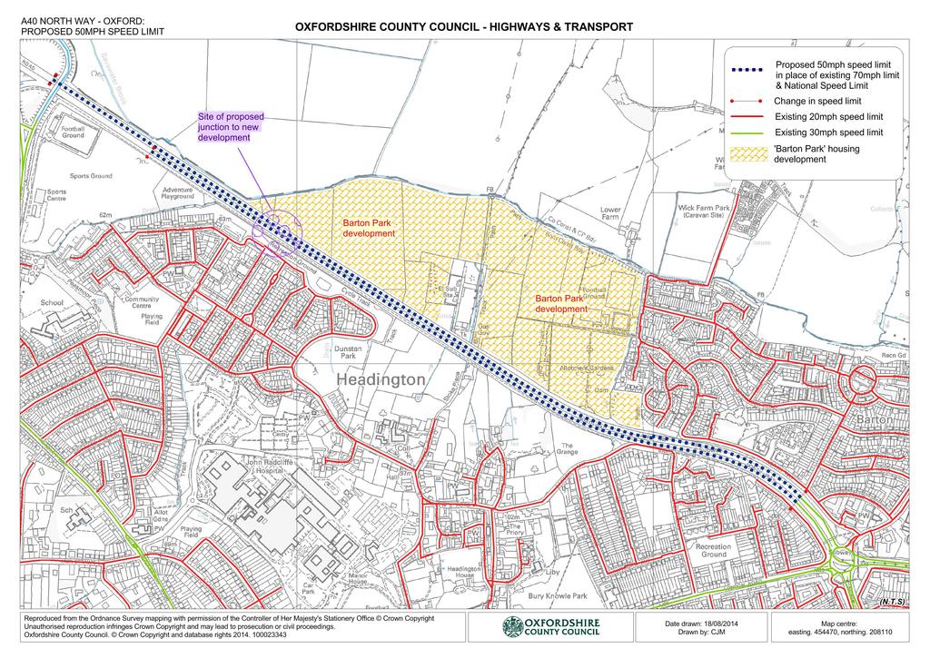
7 1. (OXFORD AREA - A40) (SPEED LIMITS) ORDER 20** 2. (OXFORD, A40 NORTHERN BYPASS - *BARTON PARK AREA) (TRAFFIC REGULATION) ORDER (CITY OF OXFORD AND NORTH HINKSEY) (BUS LANES, CYCLE LANES AND TRAFFIC MANAGEMENT) (VARIATION NO.10*) ORDER 20** Notice is hereby given that Oxfordshire County Council proposes to make the above orders under the Road Traffic Regulation Act 1984 and all other enabling powers. A signalised junction is to be created for the new Barton Park development, and to facilitate the safe operation of the junction and other affected roads, the proposed orders include the following provisions: 1. to introduce a 50mph speed limit (in place of 70mph speed limit) on the A40 northern bypass from the existing 30mph limit west of Headington roundabout to the following points: a) on the westbound carriageway for a distance of 2080 metres, and b) on the eastbound carriageway for a distance of 2430 metres. 2. Restrictions on turning movements at the junction: a) comprising a prohibition of U turns on both approaches of the A40; a prohibition of the left turn from the westbound carriageway of the A40 into the proposed link road between the A40 and Foxwell Drive+; a prohibition of the right turn from the eastbound carriageway of the A40 into the proposed link road between the A40 and Foxwell Drive+. b) A restriction of the use the proposed link road link road between the A40 and Foxwell Drive+ to limit, with only local buses and cyclists being permitted, to use the road in either direction. 3. create a short `ahead only` Bus Lane at the southbound exit from the new development for Buses (and cycles) to cross the A40. (+ Parts of these proposals will only be implemented if the new link road to Foxwell Drive is built.) The Oxfordshire County Council (Oxford Area - A40) (Speed Limits) Order 2012 will be revoked and replaced. A copy of the proposed Orders and detailed documents may be inspected at County Hall, New Road, Oxford, OX1 1ND between 9am and 4.30pm Monday to Friday. Objections to the proposals and other representations specifying the grounds on which they are made may be sent in to the address below by the 10 October The Council will consider objections and representations received in response to this Notice. They may be disseminated widely for these purposes and made available to the public. Traffic Regulation Team (Ref: AK/ ) on behalf of Director for Environment and Economy, Speedwell House, Oxford, OX1 1NE.

8 NOTE: Parts of these proposals will only be implemented if the new link road to Foxwell Drive is built. Proposed No Right-turn and, and Proposed No Left-turn
9
10 OXFORDSHIRE COUNTY COUNCIL 1. (OXFORD AREA - A40) (SPEED LIMITS) ORDER 20** 2. (CITY OF OXFORD AND NORTH HINKSEY) (BUS LANES, CYCLE LANES AND TRAFFIC MANAGEMENT) (VARIATION NO.10*) ORDER 20** 3. (OXFORD, A40 NORTHERN BYPASS - *BARTON PARK AREA) (TRAFFIC REGULATION) ORDER 2014 STATEMENT OF REASONS As a result of the development of land adjacent to the A40 at Barton and the proposed construction of a signalled junction giving access to this development, the County Council is proposing to introduce the following: 1. A 50mph speed limit extending north westwards on both carriageways of the A40 from the 30mph limit at A40 Headington roundabout to include the above proposed new signalled junction. 2. A short length of bus lane on the approach to the above junction on the access road for the development on the north east side of the A a) Restrictions on turning movements at the junction, comprising a prohibition of U turns on both approaches of the A40; a prohibition of the left turn from the westbound carriageway of the A40 into the proposed link road between the A40 and Foxwell Drive+; a prohibition of the right turn from the eastbound carriageway of the A40 into the proposed link road between the A40 and Foxwell Drive+. b) A restriction of the use the proposed link road link road between the A40 and Foxwell Drive+ to limit, with only local buses and cyclists being permitted, to use the road in either direction + Parts of these proposals will only be implemented if the new link road to Foxwell Drive is built. The County Council continues its responsibility to consider the provision of convenient and safe movement of vehicles and other traffic, and the above measures are aimed at ensuring that danger is minimised whilst facilitating the effective passage of traffic. Dated: 11 September 2014 Director for Environment & Economy Speedwell House Speedwell Road Oxford, OX1 1NE.
11 OXFORDSHIRE COUNTY COUNCIL (OXFORD AREA - A40) (SPEED LIMITS) ORDER 20** The Oxfordshire County Council ( the Council ) in exercise of its powers under Section 84 and Part IV of schedule 9 to the Road Traffic Regulation Act 1984 ( the Act ) and all other enabling powers, and after consultation with the Chief Officer of Police in accordance with Part III of schedule 9 to the Act make the following Order. 1. This Order may be cited as the Oxfordshire County Council (Oxford Area - A40) (Speed Limits) Order 20** and shall come into operation on the. day of.. 20**. 2. No person shall drive any motor vehicle at a speed exceeding 30 miles per hour in any of the lengths of road specified in Schedule 1 to this Order. 3. No person shall drive any motor vehicle at a speed exceeding 40 miles per hour in the length of road specified in Schedule 2 to this Order. 4. No person shall drive any motor vehicle at a speed exceeding 50 miles per hour in any of the lengths of road specified in Schedule 3 to this Order. 5. The length of road specified in Schedule 4 to this Order shall cease to be a restricted road for the purposes of Section 81 of The Act. 6. No person shall drive any motor vehicle at a speed exceeding 70 miles per hour in the length of road specified in Schedule 4 to this Order. 5. No speed limit imposed by this Order applies to a vehicle falling within Regulation 3(4) of the Road Traffic Exemptions (Special Forces) (Variation and Amendment) Regulations 2011, being a vehicle used for naval, military or air force purposes, when used in accordance with regulation 3(5) of those regulations. 6. The Oxfordshire County Council (Oxford Area - A40) (Speed Limits) Order 2012 is hereby revoked. GIVEN UNDER the Common Seal of the Oxfordshire County Council this. day of 20**. 30mph speed limit: SCHEDULE 1 1) The A40 London Road - within the Parishes of Oxford City and Risinghurst & Sandhills: from its junction with the A4142 at to a point 62 metres east of its Headington Roundabout, eastwards junction with Collinwood Road, Risinghurst. 1
12 2) The A40 Northern Bypass (North Way to Elsfield Way) in the Parish of Oxford City: from a point 25 metres west of its junction with Banbury Road / Cutteslowe roundabout to a point 10 metres east of its junction with Banbury Road. 3) The A40 Northern Bypass west of Headington Roundabout in the Parish of Oxford City: from its junction with the A4142 at Headington Roundabout, westwards to a point in line with the boundary of property Nos.33 & 35 North Way. 40mph speed limit: SCHEDULE 2 The A40 North Way (that is the main carriageway - not including the parallel service roads of Sunderland Avenue) within the parish of Oxford City: from its junction with Woodstock to a point 25 metres west of its Road / Wolvercote roundabout, junction with Banbury Road / eastwards Cutteslowe roundabout. SCHEDULE 3 50mph speed limit: 1) The A40 Northern Bypass - east of Banbury Road / Cutteslowe Roundabout, within the parish of Oxford City: From a point 10 metres east of its junction with Banbury Road, Roundabout, eastwards to a point 410 metres east of its junction with Jackson Road. 2) The A40 London Road east of Headington roundabout, within the parish of Risinghurst and Sandhills: From a point 62 metres east of its junction with Collinwood Road, eastwards to a point 191 metres east of its junction with Merewood Road. 3) The A40 Northern Bypass - west of Headington Roundabout, within the parishes of Oxford City and Old Marston: From a point in line with the common boundary of property Nos.33 & 35 North Way, for a distance of 452 metres. Westbound carriageway, for a distance of 2080 metres; Eastbound carriageway for a distance of 2430 metres. 2
13 To delete:- 70mph speed limit: SCHEDULE 4 The A40 Northern Bypass (North Way) west of Headington Roundabout, within the parishes of Oxford City: Both carriageways: From a point in line with the common boundary of property Nos.33 & 35 North Way, westwards for a distance of 452 metres. THE COMMON SEAL of the OXFORDSHIRE COUNTY COUNCIL was hereunto affixed in the presence of: County Solicitor / Designated Officer 3
14 OXFORDSHIRE COUNTY COUNCIL (OXFORD, A40 NORTHERN BYPASS - *BARTON PARK AREA) (TRAFFIC REGULATION) ORDER 2014 The Oxfordshire County Council ( the Council ), in exercise of its powers under Sections 1 & 2 of Schedule 9 to the Road Traffic Regulation Act 1984 ( the Act ) and all other enabling powers, and after consultation with the Chief Officer of Police in accordance with Part III of Schedule 9 to the Act, hereby makes the following Order. 1. This Order may be cited as the Oxfordshire County Council (Oxford, A40 Northern Bypass - *Barton Park Area) (Traffic Regulation) Order 20** (*or other such name as is specified by the Council) and shall come into force on the. day of 20**. 2. (1) Any reference in this Order to any enactment (meaning any act and any subordinate legislation as defined in the Interpretation Act 1978) shall be construed as a reference to that enactment as amended or replaced by any subsequent enactment; (2) Words importing the masculine gender shall also include the feminine gender and words in the singular include the plural and vice versa; (3) The restrictions imposed by this Order shall be in addition to and not in derogation from any restriction or requirement imposed by any other enactment; (4) Any reference in this Order to a numbered Article or Schedule shall unless the context otherwise requires be construed as a reference to the numbered Article or Schedule bearing that number in this Order. 3. Bus a vehicle which is constructed or adapted to carry more than 8 passengers (exclusive of the driver) and a local bus not so constructed or adapted. Local Bus a Public Service Vehicle used for the provision of a Local Service not being an excursion or tour. 4. Prohibition of Vehicles Save as provided by article 5 of this order no person shall, other than with the consent or under the direction of a police constable in uniform, cause or permit a vehicle to proceed in the section of road specified Schedule 1 to this order. 5. Nothing in Article 4 of this order shall render it unlawful for a person to cause or permit a vehicle to proceed in the specified section of road if: (1) it is a Local Bus used for a Local Service, (2) it is a cycle; or it is necessary for any of the following purposes: (3) Police, fire and ambulance services, (4) works to any road, or the supply or maintenance of water or gas, electricity, sewage or drainage and telecommunications.
15 6. Prohibition of Turns Save as provided by article 7 of this order no person shall, except with the consent or under the direction of a police constable in uniform, cause or permit a vehicle proceeding in any of lengths of road specified in column 1 of Schedule 2 to this order, to make a turn into the road and in the direction specified opposite to it in columns 2 and 3 respectively of that schedule. 7. Nothing in Article 6 of this order shall render it unlawful for a person to cause or permit a vehicle to proceed in the prohibited direction if it is necessary for the vehicle to be used for Police, fire and ambulance services in an emergency. GIVEN UNDER the Common Seal of the Oxfordshire County Council this.. day of.. 20**. SCHEDULE 1 The link road from the A40 Northern Bypass, westbound carriageway southwards, to its junction with Foxwell Drive SCHEDULE 2 Turn Prohibitions Road from Road into Prohibited Direction A40 eastbound carriageway A40 westbound carriageway A40 eastbound carriageway A40 westbound carriageway A40 westbound carriageway A40 eastbound carriageway towards Foxwell Drive towards Foxwell Drive westwards eastwards southwards southwards THE COMMON SEAL of the OXFORDSHIRE COUNTY COUNCIL was hereunto affixed in the presence of: County Solicitor / Designated Officer
THE KINGSTON UPON THAMES (BUS PRIORITY) TRAFFIC ORDER 2001
 TRAFFIC ORDER 2001") 2001 No.3 THE KINGSTON UPON THAMES (BUS PRIORITY) TRAFFIC ORDER 2001 Made: 8 th March 2001 Coming into force: 19 th March 2001 The Council of the Royal Borough of Kingston upon Thames, in exercise of the
2001 No.3 THE KINGSTON UPON THAMES (BUS PRIORITY) TRAFFIC ORDER 2001 Made: 8 th March 2001 Coming into force: 19 th March 2001 The Council of the Royal Borough of Kingston upon Thames, in exercise of the
Adjudicator s Decision
 Adjudicator s Decision Stephen Sutcliffe and Nottingham City Council Penalty Charge Notice NG93066731 60.00 Appeal allowed on the ground that the alleged contravention did not occur. I direct the Council
SLOUGH Stage 3 Road Safety Audit of A4 London Road, M4 J5 to Sutton Lane
 SLOUGH Stage 3 Road Safety Audit of A4 London Road, M4 J5 to Sutton Lane Exception Report Client Officer Rudo Beremauro Date 20 January 2015 RSA /Project Sponsor s Contents Section 3 Project Sponsor's
S C O T S. Society of Chief Officers of Transportation in Scotland. Dear Ms Johnston. Footway Parking and Double Parking (Scotland) Bill
 Bill") Society of Chief Officers of Transportation in Scotl S C O T S Chair Bill Barker Director of DGFirst Dumfries Galloway Council Cargen Tower Garroch Business Park Garroch Loan Dumfries DG2 8PN Tel No. :-
Society of Chief Officers of Transportation in Scotl S C O T S Chair Bill Barker Director of DGFirst Dumfries Galloway Council Cargen Tower Garroch Business Park Garroch Loan Dumfries DG2 8PN Tel No. :-
Drawing 5269/GA01: A2/A28 Coast bound off-slip - Wincheap Scheme
 Drawing 5269/GA01: A2/A28 Coast bound off-slip - Wincheap Scheme Notes and queries by the Wincheap Society, May 2017 Comments 1 Off the A2: Approaching the A28 junction from the north, new slip road marked
THE CORPORATION OF THE CITY OF BELLEVILLE BY-LAW NUMBER
 THE CORPORATION OF THE CITY OF BELLEVILLE BY-LAW NUMBER 2017-146 A BY-LAW TO REGULATE BICYCLES, SKATEBOARDS, IN-LINE SKATES, ROLLER SKATES, E- BIKES, SEGWAYS AND OTHER CONVEYANCES DRAWN, PROPELLED OR DRIVEN
Rhebogue Neighbourhood Greenway. Road Safety Audit Stage 2
 Rhebogue Neighbourhood Greenway Road Safety Audit Stage 2 Report Number: 12/007/00/00057 July 2014 Mid West National Road Design Office Lissanalta House, Dooradoyle County Limerick Tel: 061 496 800 Fax:
Design and Installation of Low Level Cycle Signals
 Transport for London Surface Transport Management System Document Guidance Note Design and Installation of Low Level Cycle Signals Document reference: SQA-0651 - Issue: Draft out of date information. 1
The existing site constraints which may be encountered for the A428 scheme proposals are divided into sections as follows.
 Project: A428 Study To: Cambridgeshire County Council Subject: Tidal Bus lane Review From: Atkins Date: 24 May 2016 cc: Introduction As part of the A428 Corridor Study to improve the bus journey time between
Public Consultation on Braintree Integrated Transport Package (ITP) HAVE YOUR. Consultation open from 24 September to 5 November 2018 SAY
 HAVE YOUR. Consultation open from 24 September to 5 November 2018 SAY") Public Consultation on Braintree Integrated Transport Package (ITP) HAVE YOUR SAY Consultation open from 24 September to 5 November 2018 Contents Introduction 3 Background 4 Springwood Drive Roundabout
Public Consultation on Braintree Integrated Transport Package (ITP) HAVE YOUR SAY Consultation open from 24 September to 5 November 2018 Contents Introduction 3 Background 4 Springwood Drive Roundabout
LIVESTOCK MOVEMENT BYLAW 2008
 HURUNUI DISTRICT COUNCIL LIVESTOCK MOVEMENT BYLAW 2008 1.0 SHORT TITLE AND COMMENCEMENT 1.1 This bylaw is made pursuant to section 145 of the Local Government Act 2002. 1.2 This bylaw is the Hurunui District
Economic and Social Council
 UNITED NATIONS E Economic and Social Council Distr. GENERAL TRANS/WP.1/2003/3/Rev.4 23 April 2004 ENGLISH Original: ENGLISH, FRENCH and RUSSIAN ECONOMIC COMMISSION FOR EUROPE INLAND TRANSPORT COMMITTEE
SCHEME DESIGN AND ENGINEERING
 THE NORTH SOMERSET COUNCIL (SOUTH BRISTOL LINK CLASSIFIED ROAD) SIDE ROADS ORDER 2013 THE NORTH SOMERSET COUNCIL (SOUTH BRISTOL LINK) COMPULSORY PURCHASE ORDER 2013 THE NORTH SOMERSET COUNCIL (SOUTH BRISTOL
TORONTO MUNICIPAL CODE CHAPTER 886, FOOTPATHS, PEDESTRIAN WAYS, BICYCLE PATHS, BICYCLE LANES AND CYCLE TRACKS. Chapter 886
 Chapter 886 FOOTPATHS, PEDESTRIAN WAYS, BICYCLE PATHS, BICYCLE LANES AND CYCLE TRACKS 1 886-1. Definitions. 886-2. Paths established. 886-3. Vehicles excluded; exceptions. 886-4. Pedestrian ways established.
Warwickshire County Council proposes to make the following named orders:
 THE WARWICKSHIRE COUNTY COUNCIL (DISTRICT OF WARWICK) (CIVIL ENFORCEMENT AREA) (WAITING RESTRICTIONS, ON-STREET PARKING PLACES AND RESIDENTS PARKING) (VARIATION NO 2, A & B) (CONSOLIDATION) ORDER 2017
62 CHURCH ROAD WHEATLEY OXFORD OX33 1LZ
 WHEATLEY PARK SCHOOL, A4142, A34 Park Hill Holloway Road JOHN WATSON SCHOOL Littlewood Road High Street Holloway Road WE ARE HERE THE PARISH CHURCH OXFORD BROOKES UNIVERSITY, WHEATLEY CAMPUS, M40 JCT 8/8A
The Cabinet Member for Highways & Streetscene. Aurang Zeb - Head of Highways & Transport
 LONDON BOROUGH OF RICHMOND UPON THAMES Cabinet Member Decision DATE: January 2012 REPORT OF: LEAD OFFICER: SUBJECT: WARDS: The Cabinet Member for Highways & Streetscene Aurang Zeb - Head of Highways &
MARKHOUSE ROAD IMPROVEMENTS
 MARKHOUSE ROAD IMPROVEMENTS www.enjoywalthamforest.co.uk Waltham Forest is changing and we want you to be part of it. Thanks to a funding pot of 27million from Transport for London, we re delivering the
Appendix 12 Parking on footways and verges
 Appendix 12 Parking on footways and verges Legal position Parking on footways and verges whether wholly or partly is banned throughout London, unless signs are placed to allow parking. The ban requires
CHAPTER 71: TRAFFIC RULES. Operation Generally. Accidents. Prohibitions
 CHAPTER 71: TRAFFIC RULES Section 71.01 Obstructing traffic 71.02 Reverse or U turns 71.03 Backing vehicles 71.04 Vehicles crossing sidewalks 71.05 Speed limits 71.15 Duty of operator 71.16 Accident report
Guide to the Cycle Enfield Public Consultation on Enfield Town. Produced by the Save Our Enfield Town Campaign Group
 Guide to the Cycle Enfield Public Consultation on Enfield Town Produced by the Save Our Enfield Town Campaign Group What s in this guide? Introduction Page 3 What Enfield Council says about Option 1 Page
sessions. The opinions of local people will help decide which of these two options is taken forward to be built.
 A4018 FAQs Why are no bus lanes proposed north of Crow Lane? Inbound and outbound bus lanes were considered north of the Crow Lane junction, but they took away capacity from other traffic on the approach
Chapter 4 Route Window C3 Hyde Park and Park Lane shafts. Transport for London
 Chapter 4 Route Window C3 Hyde Park and Park Lane shafts Transport for London HYDE PARK AND PARK LANE SHAFTS 4 Route Window C3 Hyde Park and Park Lane shafts Introduction 4.1 In this route window, which
Marcus Jones, TRL. Presented by Name Here Job Title - Date
 Segregation Insert the title and of priority your at presentation junctions: a here discussion Marcus Jones, TRL Presented by Name Here Job Title - Date Background: TfL cycle facility trials Infrastructure
Traffic Calming Regulations
 Traffic Advisory Leaflet 7/93 August 1993 Traffic Calming Regulations Introduction Traffic calming can help drivers to make their speeds appropriate to local conditions, through measures which are self-enforcing.
Consultation Report & Results August 2016
 Queen Edith s Way Consultation Report & Results August 216 Summary The consultation on walking and cycling improvements along Queen Edith s Way took place from 2 June to 1 August 216. A total of 64 survey
Birmingham City Council
 Birmingham City Council A summary of the recommendations for the calculation of Saturation Flows at Traffic Signals. Index to Recommended Method of Calculating Saturation Flows 1 Introduction 2 Summary
Cyclists at road narrowings
 Traffic Advisory Leaflet 1/97 February 1997 Cyclists at road narrowings Introduction Traffic calmed streets can offer a more attractive environment for cycling, by reducing motor vehicles speeds to a level
Improving Cyclist Safety at the Dundas Street West and Sterling Road Intersection
 STAFF REPORT ACTION REQUIRED Improving Cyclist Safety at the Dundas Street West and Sterling Road Intersection Date: August 17, 2012 To: From: Wards: Reference Number: Public Works and Infrastructure Committee
Traffic calming regulations (Scotland)
") Traffic Advisory Leaflet 11/94 December 1994 Traffic calming regulations (Scotland) Introduction Traffic calming can help drivers to make their speeds appropriate to local conditions, through measures
Traffic Advisory Leaflet 11/94 December 1994 Traffic calming regulations (Scotland) Introduction Traffic calming can help drivers to make their speeds appropriate to local conditions, through measures
Purpose: Financial Implications and Impact Statement: It is estimated that the cost to implement:
 Various Modifications Lower Jarvis Street and Lake Shore Boulevard East; Lower Jarvis Street, east side, between Lake Shore Boulevard East and The Esplanade - 45-77 Lower Jarvis Street; and Lower Jarvis
Commonwealth Heads of Government Meeting: London 2018
 Commonwealth Heads of Government Meeting: London 2018 Resident and Business Factsheet Location: The Royal Parks, the Commonwealth Village and the QEII Centre Impact dates: Saturday 14 to Sunday 22 April
TS 109 DURHAM ROAD QTC PHASE 4 PROJECT PROPOSAL. Page 1
 TS 109 DURHAM ROAD QTC PHASE 4 PROJECT PROPOSAL Page 1 Table of Contents 1.0 Introduction... 3 2.0 Project Overview... 3 3.0 Project Proposals... 4 3.1 Enfield Road / Durham Road Junction... 3 5 3.2 Summerfield
Traffic Sensitive Streets. Guidance Notes. GeoPlace Streets Team. Traffic Sensitive Streets. Guidance Note Page 1 of 7.
 Guidance Notes GeoPlace Streets Team Guidance Note Page 1 of 7 Introduction The guidance note provides information on the definition, role and value of. It will also focus on how and why Traffic Sensitive
Advanced Stop Lines. Advanced Stop Lines are a low-cost but highly-effective way of helping cyclists at junctions,
 Cambridge Cycling Campaign Advanced Stop Lines 1 Advanced Stop Lines Advanced Stop Lines are a low-cost but highly-effective way of helping cyclists at junctions, and are becoming increasingly common in
The Consultation has now ended.
 The Consultation has now ended. We have received Cabinet Member approval to undertake implementation of the Baker Street Two Way scheme. You are not viewing the most recent documentation. Please visit
Frascati Road and Temple Hill Route Improvements. Outline Design Report to Accompany Public consultation
 Frascati Road and Temple Hill Route Improvements Outline Design Report to Accompany Public consultation September 2013 Background: Dún Laoghaire-Rathdown is committed to providing high quality pedestrian
Road Markings. Lecture Notes in Transportation Systems Engineering. Prof. Tom V. Mathew
 Road Markings Lecture Notes in Transportation Systems Engineering Prof. Tom V. Mathew 1 Overview The essential purpose of road markings is to guide and control traffic on a highway. They supplement the
Issues at T junctions:
 TheSlade_PublicConsulationPlans_March2017.pdf These comments relate to junction designs in this phase of the project on The Slade. Comments begin with the northernmost junction: Girdlestone Rd and continue
TITLE VII: TRAFFIC CODE 70. GENERAL PROVISIONS 71. TRAFFIC RULES 72. PARKING REGULATIONS 73. BICYCLES AND MOTORCYCLES 74.
 TITLE VII: TRAFFIC CODE Chapter 70. GENERAL PROVISIONS 71. TRAFFIC RULES 72. PARKING REGULATIONS 73. BICYCLES AND MOTORCYCLES 74. TRAFFIC SCHEDULES 75. PARKING SCHEDULES 1 2 Vine Grove - Traffic Code CHAPTER
ECONOMY PEOPLE ENVIRONMENT
 Report Back on Local Transit Improvements May 29, 2013 ECONOMY PEOPLE ENVIRONMENT Intro Council Requested Report Back Topics Progress on Planning for Broadway Subway False Creek Bridges Local Transit Improvements
LEA BRIDGE ROAD - A STREET FOR EVERYONE Public consultation document
 LEA BRIDGE ROAD - A STREET FOR EVERYONE Public consultation document TELL US Bakers Arms to Leyton Green Road (Section D, E, F) Leyton Green Road to Whipps Cross Roundabout (Section G) YOUR VIEWS www.enjoywalthamforest.co.uk
MILTON ROAD ~ MITCHAM'S CORNER PARAMICS MODEL INITIAL OPTION TESTING
 MILTON ROAD ~ MITCHAM'S CORNER PARAMICS MODEL INITIAL OPTION TESTING NOVEMBER 216 MILTON ROAD ~ MITCHAM'S CORNER PARAMICS MODEL INITIAL OPTION TESTING Cambridgeshire County Council Type of document (version)
1 VicRoads Access Management Policies May 2006 Ver VicRoads Access Management Policies May 2006 Version 1.02
 1 VicRoads Access Management Policies May 2006 Ver 1.02 VicRoads Access Management Policies May 2006 Version 1.02 2 VicRoads Access Management Policies May 2006 Ver 1.02 FOREWORD FOR ACCESS MANAGEMENT
Appendix A Type of Traffic Calming Measures Engineering Solutions
 Appendix A Type of Traffic Calming Measures Engineering Solutions PHYSICAL MEASURES Central Hatching The major consideration of this feature is that, these markings can only be laid down the centre of
PROPOSED RESIDENTIAL SUBDIVISION
 PROPOSED RESIDENTIAL SUBDIVISION PART OF TARNEIT ROAD & 1121 DOHERTYS ROAD, TARNEIT Prepared For: TCG (RM) Developments Pty Ltd MARCH 2014 OUR REF: 16740R#1 PROPOSED RESIDENTIAL SUBDIVISION PART OF TARNEIT
Chapter 4 - Links Within the Highway. Suitability of Routes
 Chapter 4 - Links Within the Highway Suitability of Routes Most cycling takes place on existing urban roads; this will also be the case with the National Cycle Network. As well as following lightly trafficked
CHURCH ROAD. Public consultation document TELL US YOUR VIEWS.
 CHURCH ROAD Public consultation document YOUR TELL US VIEWS www.enjoywalthamforest.co.uk CHURCH ROAD Introduction Waltham Forest Council was one of three boroughs to be awarded 27million of funding from
Smart motorways: all lane running on the M25. Guidance for EEAST crews
 Smart motorways: all lane running on the M25 Guidance for EEAST crews Published April 2014 Background This month (April 2014) the Highways Agency launched its smart motorways, which make use of new technology
MUNICIPALITY OF ANCHORAGE TRAFFIC CODE UPDATE MASTER RECOMMENDATION REPORT: 9.14, 9.16, 9.18
 MUNICIPALITY OF ANCHORAGE TRAFFIC CODE UPDATE MASTER RECOMMENDATION REPORT: 9.14, 9.16, 9.18 Report Date: Please send all recommendations for update to Shane Locke (343-8413, lockesr@muni.org) 8-Apr-09
4. Guided Bus Explained
 4. Guided Bus Explained Contents 1 INTRODUCTION... 2 Structure of this report... 2 2 KERB GUIDED BUS... 3 Overview... 3 Kerb guidance... 3 Figures Figure 2.1 Figure 2.2 Figure 2.3 Figure 2.4 Figure 2.5
APPENDIX F: TECHNICAL NOTE 22 (VICARAGE ROAD JUNCTION)
") APPENDIX F: TECHNICAL NOTE 22 (VICARAGE ROAD JUNCTION) West Midlands Interchange Transport Assessment DCO Submission WEST MIDLANDS INTERCHANGE SUBJECT: Technical Note 22 Review of Vicarage Road Junction
APPENDIX F: TECHNICAL NOTE 22 (VICARAGE ROAD JUNCTION) West Midlands Interchange Transport Assessment DCO Submission WEST MIDLANDS INTERCHANGE SUBJECT: Technical Note 22 Review of Vicarage Road Junction
BETTER CONDITIONS TO ACHIEVE LOWER RISK FOR PEDESTRIANS IN THE INTERSECTION PLAZA ESPAÑA AV. REINA Mª CRISTINA IN BARCELONA
 BETTER CONDITIONS TO ACHIEVE LOWER RISK FOR PEDESTRIANS IN THE INTERSECTION PLAZA ESPAÑA AV. REINA Mª CRISTINA IN BARCELONA Intersecting safely (International Student Competition) Author: Jose Mª Ortiz
THE CORPORATION OF THE TOWNSHIP OF WOOLWICH BY-LAW NUMBER BEING A BY-LAW TO REQUIRE PRIVATELY OWNED POOLS TO HAVE FENCES
 1 THE CORPORATION OF THE TOWNSHIP OF WOOLWICH BY-LAW NUMBER 52-2007 BEING A BY-LAW TO REQUIRE PRIVATELY OWNED POOLS TO HAVE FENCES WHEREAS the Municipal Act, S.O. 2001, empowers Councils of Municipalities
A by-law to regulate pool enclosures within the Town of Oakville
 THE CORPORATION OF THE TOWN OF OAKVILLE BY-LAW NUMBER 2006-071 A by-law to regulate pool enclosures within the Town of Oakville WHEREAS section 11 of the Municipal Act, 2001, S.O. 2001, c. 25, as amended,
How do we design for pedestrians? Case study: transforming the Walworth Road
 How do we design for pedestrians? Case study: transforming the Walworth Road David Moores, Director of Public Realm Institution of Highways and Transportation, November 2009 Presentation overview Design
Cabinet Member for Highways & Streetscene. Highway Infrastructure Manager
 LONDON BOROUGH OF RICHMOND UPON THAMES DATE: AUGUST 2015 DECISION MAKER: LEAD OFFICER: SUBJECT: WARDS: Cabinet Member for Highways & Streetscene Highway Infrastructure Manager PROPOSED CYCLING IMPROVEMENTS
DESIGN CODE. Enterprise West Harlow London Road North Design Code 21
 DESIGN CODE Enterprise West Essex @ Harlow London Road North Design Code 21 4 MAXIMUM BUILDING HEIGHTS 4.1 Table 4A sets out maximum building height standards for each character area within the LDO boundary.
EDINBURGH 4TH NOVEMBER Notice of Road Closures & Parking Restrictions
 EDINBURGH 4TH NOVEMBER 2018 1 Notice of & Please find enclosed in this booklet details of all road closures and parking restrictions for the Men s 10K which takes place on Sunday 4th November 2018. The
Kings Road, Herne Bay: Proposed Crash Remedial Measure
 Kings Road, Herne Bay: Proposed Crash Remedial Measure To: Canterbury Joint Transportation Board 17 February 2015 By: Classification: Ward: Tim Read - Head of Transportation Unrestricted Herne Bay Summary:
December 6, Mayor West, Vice Mayor de Triquet and Members of the City Council
 Ct1Saj) eake VIRGINIA Office of the City Attorney 23322 757) 382-6586 Fax( 757) 382-8749 December 6, 2017 To: Mayor West, Vice Mayor de Triquet and Members of the City Council Re: AN ORDINANCE TO AMEND
IAN WHITE ASSOCIATES. Crawley Station Gateway Public Realm
 IAN WHITE ASSOCIATES Crawley Station Gateway Public Realm contents 1. objectives & client brief 2. site appraisal 3. best practice guidance 4. design concept 1. objectives & client brief Crawley Train
AT403.1 Ancient monument Note 3 amended P500 Basic triangle New size 1800mm added
 AT403.1 P666 P874 P1028.4 P2509.1 P5001.2 P500 P672 P875 P1032 P2511.1 P5010 P530A P673 P876 P1033 P2512.1 P5011 P530.1 P784.1 P877 P1050 P2601.1 P7005 P543 P786 P878 P2010.1 P2601.1A P7009.1 P563.1 P787
MILTON ROAD LLF PROJECT UPDATE
 Greater Cambridge City Deal MILTON ROAD LLF PROJECT UPDATE 9 th May 2017 Project objectives Comprehensive priority for buses in both directions wherever practicable; Additional capacity for sustainable
Welcome. If you have any questions or comments on the project, please contact:
 Welcome This drop-in public open house is intended to provide information about the Bay Street bike lanes project. This project proposes a dedicated cycling facility along Bay Street between Aberdeen Avenue
Bramshaw traffic calming proposal
 - 1 - Bramshaw traffic calming proposal Initial options appraisal report July 2017 - 2-1. Project background Hampshire Country Council has commissioned Test Valley Borough Council to carry out an option
THE CORPORATION OF THE CITY OF BELLEVILLE BY LAW NUMBER
 THE CORPORATION OF THE CITY OF BELLEVILLE BY LAW NUMBER 2006 65 A BY LAW TO PRESCRIBE THE HEIGHT AND DESCRIPTION OF, AND THE MANNER OF ERECTING AND MAINTAINING FENCES AND GATES SURROUNDING PRIVATELY OWNED
E4 Cycle Route Exeter University to Redhayes Bridge. - Recommendations from Exeter Cycling Campaign
 E4 Cycle Route Exeter University to Redhayes Bridge - Recommendations from Exeter Cycling Campaign 1.0 Introduction Exeter Cycling Campaign has prepared this report to provide recommendations for Devon
M9/A90/M90 Edinburgh to Fraserburgh Trunk Road. A90 Tealing. Moving Cursor Programme Junction Study
 A90 Tealing Moving Cursor Programme Junction Study This is an unpublished report prepared for the Transport Scotland, Trunk Road and Bus Operations Division (TRBO) and must not be referred to in any publication
Public Works and Infrastructure Committee. General Manager, Transportation Services
 STAFF REPORT ACTION REQUIRED Extending the Bay Street Bicycle Lanes Date: May 16, 2013 To: From: Public Works and Infrastructure Committee General Manager, Transportation Services Wards: Toronto Centre
Tel: Karime Hassan Chief Executive Exeter City Council Civic Centre Paris Street Exeter EX1 1JN
 Page 1 of 6 Karime Hassan Chief Executive Exeter City Council Civic Centre Paris Street Exeter EX1 1JN Dear Mr Hassan 14th September 2015 Re: Development of Bus & Coach Station Site Following the submission
A52. Nottingham Junctions. Construction at Nottingham Road and Cropwell Road junctions commencing early January 2017
 Nottingham Junctions Construction at Nottingham Road and Cropwell Road junctions commencing early January 2017 Introduction The is the key east-west link across the East Midlands. The route is subject
Senate Amendment to Senate Bill No. 354 (BDR ) Amends: Summary: Yes Title: Yes Preamble: No Joint Sponsorship: No Digest: Yes
 Amends: Summary: Yes Title: Yes Preamble: No Joint Sponsorship: No Digest: Yes") 0 Session (th) A SB Amendment No. Senate Amendment to Senate Bill No. (BDR -) Proposed by: Senate Committee on Transportation Amends: Summary: Yes Title: Yes Preamble: No Joint Sponsorship: No Digest:
0 Session (th) A SB Amendment No. Senate Amendment to Senate Bill No. (BDR -) Proposed by: Senate Committee on Transportation Amends: Summary: Yes Title: Yes Preamble: No Joint Sponsorship: No Digest:
Chelmsford City Growth Package
 Chelmsford City Growth Package Public Consultation Document Volume 2 West Chelmsford July - August 2017 Chelmsford City Growth Package Public Consultation Document - Volume 2 - West Chelmsford Contents
A127/A130 Fairglen Interchange Improvement Schemes. Information Leaflet February 2017
 A127/A130 Fairglen Interchange Improvement Schemes Information Leaflet February 2017 1 2 Foreword By Councillor Kevin Bentley Essex is continuing to grow as a vibrant economic hub and as a fantastic place
Cycle Superhighway 4 from Tower Bridge to Greenwich
 Cycle Superhighway 4 from Tower Bridge to Greenwich About Sustrans Sustrans is the charity making it easier for people to walk and cycle. We are engineers and educators, experts and advocates. We connect
Road Markings. Lecture Notes in Transportation Systems Engineering. Prof. Tom V. Mathew. 1 Overview 1. 2 Classification 2
 Road Markings Lecture Notes in Transportation Systems Engineering Prof. Tom V. Mathew Contents 1 Overview 1 2 Classification 2 3 Longitudinal markings 2 3.1 Center line.....................................
S 0659 S T A T E O F R H O D E I S L A N D
 LC0 0 -- S 0 S T A T E O F R H O D E I S L A N D IN GENERAL ASSEMBLY JANUARY SESSION, A.D. 0 A N A C T RELATING TO MOTOR AND OTHER VEHICLES - TRAFFIC CONTROL DEVICES Introduced By: Senators McCaffrey,
The Wincheap Society
 The Wincheap Society s on sections of: Thanington 4th Arm Slip Road, Walking, Cycling & Horse-Riding Assessment & Review Report, by Peter Brett Associates, October 2017, on behalf of Pentland Properties
Attachment A: Traffic Mitigation Measures
 Attachment A: Traffic Mitigation Measures Central Interceptor Main Project Works Watercare Services Limited This appendix outlines examples of detailed mitigation measures that could be implemented for
Ministry of Education Flat Bush School Notice of Requirement. Integrated Transportation Assessment Report. February 2016
 Ministry of Education Flat Bush School Notice of Requirement Integrated Transportation Assessment Report February 2016 TDG Ref: 12988-2 151105 ita flat bush.docx Ministry of Education Flat Bush School
Union Street roundabout Turbo-style roundabouts the future? Patrick Lingwood Walking and Cycling Officer Bedford Borough Council
 Union Street roundabout Turbo-style roundabouts the future? Patrick Lingwood Walking and Cycling Officer Bedford Borough Council Presentation outline Local importance and problems we faced The evolution
Bicycle Traffic Control Signal - St. Clair Avenue West and Poplar Plains Road
 PW17.11 REPORT FOR ACTION Bicycle Traffic Control Signal - St. Clair Avenue West and Poplar Plains Road Date: November 4, 2016 To: Public Works and Infrastructure Committee From: Acting General Manager,
Chicane Schemes. Traffic Advisory Leaflet 12/97 December Introduction
 Traffic Advisory Leaflet 12/97 December 1997 Chicane Schemes Introduction Traffic Advisory Leaflet 9/94 "Horizontal Deflections" reported on the results of track trials carried out by the Transport Research
MACKEREL LICENSING (MANX AND CHANNEL ISLANDS BOATS) ORDER 1978
 ORDER 1978") MACKEREL LICENSING (MANX AND CHANNEL ISLANDS BOATS) ORDER 1978 JERSEY REVISED EDITION OF THE LAWS 14.300 APPENDIX 3 Jersey R & O 6631 Sea Fish (Conservation) Act 1967. MACKEREL LICENSING (MANX AND CHANNEL
MACKEREL LICENSING (MANX AND CHANNEL ISLANDS BOATS) ORDER 1978 JERSEY REVISED EDITION OF THE LAWS 14.300 APPENDIX 3 Jersey R & O 6631 Sea Fish (Conservation) Act 1967. MACKEREL LICENSING (MANX AND CHANNEL
CHECKLIST 2: PRELIMINARY DESIGN STAGE AUDIT
 CHECKLIST 2: PRELIMINARY DESIGN STAGE AUDIT 2.1 General topics 2.1.1 Changes since previous audit Do the conditions for which the scheme was originally designed still apply? (for example, no changes to
Bylaw No SPEED BYLAW PAGE 1 Code 04/10
 PAGE 1 Code 04/10 A BYLAW OF THE CITY OF LEDUC IN THE PROVINCE OF ALBERTA, TO PRESCRIBE SPEED LIMITS ON HIGHWAYS OR ROADWAYS IN THE MUNICIPAL BOUNDARIES The Traffic Safety Act, R.S.A. 2000, Chapter T-6,
Sevenways Roundabout, and the need for a Road Safety Scheme:
 Sevenways Roundabout, and the need for a Road Safety Scheme: The way the current roundabout has evolved has obviously created an environment that is dangerous for all road users, motorists, cyclists and
National Cycle Network Route 81 Wolverhampton Cross City Route August 2005
 Page 12 Buses often stop in Lichfield Street and there is no space to pass. Should an NCN route be following a road which is heavily congested with buses and diesel fumes? 14. Railway Drive The dropped
LONDON BUSES - ROUTE DESCRIPTION
 LONDON BUSES - ROUTE DESCRIPTION Printed On: 26 January 2011 10:42:20 ROUTE N19: Finsbury Park Station - Clapham Junction, St Johns Hill Date of Structural Change: 3 March 2012. Date of Service Change:
SH1, Karo Drive Wellington Crash Reduction Study
 SH1, Karo Drive Wellington Crash Reduction Study A REPORT PREPARED FOR New Zealand Transport Agency Reference: 12334 January 2013 Hawke s Bay office: PO Box 28 208, Havelock North 4157 Tel: (06) 877 8040
Improve the livability of our streets by
 Pedestrian and Traffic Calming Policy March 2018 2 of 6 Neighborhood Traffic Calming Policy The City of Aspen continually strives to protect multimodal function while maintaining a high standard of safety.
Derby Cycling Group, c/o 126, Station road, Mickleover, Derby, DE3 9FN. Date: 20 th November, 2018.
 Your Ref: Derby City Council Air Quality - Preferred Option Nov 2018 Derby Cycling Group, c/o 126, Station road, Mickleover, Derby, DE3 9FN Date: 20 th November, 2018. 1. Introduction: 1.1. Derby Cycling
Land Transport Rule Traffic Control Devices 2004
 WELLINGTON, NEW ZEALAND PURSUANT to Section 152 of the Land Transport Act 1998 I, Harry James Duynhoven, Minister for Transport Safety, HEREBY make the following ordinary rule: Land Transport Rule: Traffic
Scheme Category. Traffic Management. Traffic Management. Implementation LBAS ,000. Traffic Management. Traffic Management. Traffic Management
 90,000 Ref Location Description Requested by Scheme Category Scheme stage Cost Code Estimated cost Comments RA London Road, Wickford close to no 63 2 Twinstead, Wickford 3 4 5 6 7 B48 Westmayne / Ford
Cycling Safety Review. (April 2017)
") Cycling Safety Review (April 2017) Background Analysis of STATS19 database: - Only includes incidents where police were in attendance, or where the crash was subsequently reported to the police - Significantly
Cycling Safety Review (April 2017) Background Analysis of STATS19 database: - Only includes incidents where police were in attendance, or where the crash was subsequently reported to the police - Significantly
Tunnel Reconstruction Brooklyn CB 1 August 14, 2018
 Tunnel Reconstruction Brooklyn CB 1 August 14, 2018 Reconstructing the Tunnel 2 Service During Tunnel Reconstruction April 2019 through July 2020 3 Projected Cross River Travel Paths of Customers The Service
A6 Manchester Airport Relief Road
 A6 Manchester Airport Relief Road Status Date Author Approved for Issue (AECOM) Approved for Issue (Grontmij) P0 18 July 2014 Adam Richardson Martin Houghton Martin Williamson P1 06 August 2014 Tony Hickman
West Midlands Cycle Design Guidance Cycling and the Midland Metro
 Transport for the West Midlands Cycling and the Midland Metro September 2017 Project Code: 02821 Phil Jones Associates Ltd Seven House High Street Longbridge Birmingham B31 2UQ philjonesassociates.co.uk
Maynooth Cycling Submission on North South Corridor
 Maynooth Cycling Submission on North South Corridor Maynooth Cycling welcomes the intention to improve facilities and quality of service for pedestrians and cyclists in Maynooth. In particular, we strongly