Baidu Apollo HD Map 21/11/2018. Intelligent Transportation and Autonomous Vehicles. Introduction to Dr. Ma Changjie. Organizer:
|
|
|
- Judith Dalton
- 5 years ago
- Views:
Transcription


;")


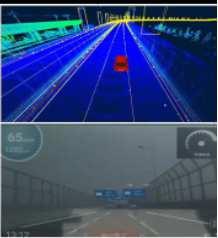
1 21/11/2018 Intelligent Transportation and Autonomous Vehicles Introduction to Dr. Ma Changjie Chief software Architect of high-precision map of intelligent automobile department of Baidu, Inc.; Ph.D of China University of Geosciences(Wuhan); Research interests: Geographical Information Science, Autonomous Driving, Navigation & HD Map; Organizer: 1 Baidu Apollo HD Map Dr. Ma Changjie Nov

2 Open Capability Shared Resources Accelerated Innovation Sustained Mutual Benefit Apollo Framework! HD Map Simulation Platform Security OTA DuerOS Map Engine Localization Perception Planning Control End-to-End HMI Runtime Framework RTOS Computing Unit GPS / IMU Camera LiDAR Radar HMI Device Black Box Drive-by-wire Vehicle 2


![ŽŽƒonop lg n gž knhƒj žÿ dcd dÿ ]Ÿ](/docs-images/93/114477092/images/3-9.jpg "ad«š_ [dc ±² ³ µ ³ º» ¼ ³ ¹d š [_ ][")

3 Apollo is Accelerating Innovation for Autonomous Driving "#$%&' "#$%&% "#$%&( "#$)&$ "#$)&' *+,,-./-,,-./-,,- 012./-,,- 013./-,,- 412./-,, :;<7=> D87EBC G=:AHI?J K=ILI?J MINBC O:?B K=ILI?J K=ILI?J <7= PI>68B Q=R:? S7:C D7?CI;I7?E FIEI7?UR:EBC VIJWX:Y K=ILI?J I? OI>I;BC 5=B: "#$)&%./-,,- T12 Q6J=:CBC , ,000+ Partners Developers Lines of code Apollo Pilot: Making Driving Safer ÉÊËÌÍÎÏÐÍÑÍÒÓ ÔÕÖÒ ÐÍØÙ GY6BE Z[\]^_`ab[c\ bd_e fghij kglmnop qrsttuv wsx ysxz{ }np~g nop ƒg l n nop _ _ [dc fghij kglmnop ŽŽƒonop lg n gž knhƒj žÿ dcd dÿ ]Ÿ ad«š_ [dc ±² ³ µ ³ º» ¼ ³ ¹d š [_ ][ Ár uâ¾ã Ä{ ˆ jƒ goiš ~gopnop š_ [ œ_ ÅuÀÆ uç ÅuÈuÆ uç Œ go lgž žÿ d _ [ _ _š [c\ jƒ ƒ ƒlji jgjnƒo kglmnop jg hi Œªg nƒo ½¾sr À ysr 3
 HD Map Dynamic ( RTTI, Traffic Events etc.")
4 Apollo HD Map One Road Network Architecture Full-Scenario Features AI Driven Technology One Road Network Architecture AD Assisted Driving (e.g. Speed up, Slow down, etc.) HD Map Dynamic ( RTTI, Traffic Events etc.) Lane-Level Navigation Sensor Feature Lane Topology Parking Facility Traffic Signs Adapter/Cross-reference SD Map Road-Level Navigation BMD POI Routing Names Road Network 4


5 One Road Network Architecture Full-Scenario Features: Highway & Expressway Features Lane Marking Geometry Lane Marking Color Lane Marking Style Lane Marking Material Lane Marking Width Lane Construction State Lane Number Lane Width/Type Lane Centerline Lane Topology Max/Min Speed Limit Junction Overpass Guardrail/Curb Arrows/Words Beijing Shanghai Lane Centerline Lane Marking Geometry Lane Marking Style Lane Marking Color Guardrail Curb Arrow Overpass 5


6 Full-Scenario Features: Urban Road & Close Area Features Lane Marking Geometry Lane Marking Color Lane Marking Style Lane Marking Material Lane Marking Width Lane Construction State Virtual Lane Connectivity of Intersection Intersection Boundary Traffic Light Stop Line Speed Bump Zebra Line Overpass Traffic Sign No Parking Area Road Intersection Speed Bumps No Parking Area Full-Scenario Features: Parking Facility Features Parking Facility Region Parking Space ID Parking Space Geometry Parking Wheel Marker Parking Lane Marking Pole Drivable Area Connection to Road Handover Zone Arrow No Parking Area Zebra Line Curvature Traffic Sign Ramp Area Parking Facility Region Parking Space ID &wheel marker Lane Marking & traffic sign 6


7 AI Driven Technology: HD Map Production Pipeline Sourcing Backend Automation Map making & Validation Map Compile & Release Point Cloud Fusion& Recognition Mapmaker NDS Release GPS GPS Track Fusion Pole IMU Point Cloud Curb Guardrail Map production management LiDAR Photo image Arrow Signboard Image Recognition Camera Lane marking Traffic sign AI Driven Technology: Point Clouds & Images Automated Processing PCF&PCR TSR MSF Motion Compensation 3D Modeling Feature extraction Point Cloud Fusion Point Cloud Recognition Image Recognition 3D->2D Mapping Element track cluster Filter & fill-up Deep Learning Neural Network (CNN/RCNN/RNN) 7


8 AI Driven Technology: Point Clouds & Images Automated Recognition Feature Accuracy rate Lane Marking 96.6% Guardrail 99.1% Curb 99.1% Sign 95.4% Pole 95.5% Lane marking and Guardrail in China about 50 types Chinese standard traffic sign list above, 200 types or so. AI Driven Technology: Intelligent Map Ecosystem Smartphone Crowd-Sourcing In-Car Smart Device Intelligent Connected Car Autonomous Driving Car DC DC SD/HD DC HD DC Intelligent Map Platform Baidu Survey Fleet 8


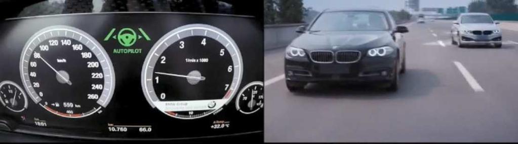

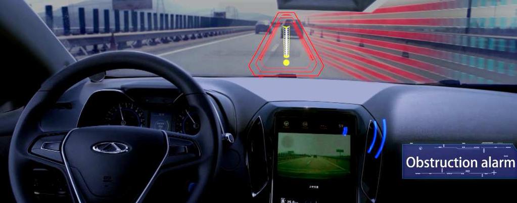


9 Open Road testing with BMW/Bosch/Cherry BMW AD road testing on Open road 2016 Bosch AD road testing on SuZhou Highway 2017 Cherry AD road testing on Wuhu Highway 2018 OEM Partners Testing Reports & Nomination 9
10 Thanks 10
Collision Avoidance based on Camera and Radar Fusion. Jitendra Shah interactive Summer School 4-6 July, 2012
 Collision Avoidance based on Camera and Radar Fusion Jitendra Shah interactive Summer School 4-6 July, 2012 Agenda Motivation Perception requirements for collision avoidance Situation classification and
 http://en.wikipedia.org/wiki/darpa_grand_challenge - The Urban Challenge requires designers to build vehicles able to obey all traffic laws while they detect and avoid other robots on the course. This
Application of new information system and technologies to road management & control at ANAS S.p.A.
 November 6th - 8th, 2013 Hotel Panamericano City of Buenos Aires, Argentina URBAN MOBILITY, ROADS NETWORK OPERATION AND ITS APPLICATIONS Application of new information system and technologies to road management
Situations that a B2/ALKS highway system may encounter
 Submitted by Industry Informal Document - ACSF-20-05 Situations that a B2/ALKS highway system may encounter Purpose and key messages of this document: This document aims at providing a better understanding
Smart Bike as the 1 persons car of the future
 Smart Bike as the 1 persons car of the future www.smartmobilitysolutions.be Guy Spleesters Smart Mobility Solutions Content Why move from cars to bicycles What are the obstacles What could motivate to
Self-Driving Vehicles That (Fore) See
 See") Self-Driving Vehicles That (Fore) See Dariu M. Gavrila Intelligent Vehicles, TU Delft Berlin Tech.AD, March 5, 2018 Personal Introduction: Dariu M. Gavrila Born in Cluj (Romania) 1990 Doktoraal Degree
Self-Driving Vehicles That (Fore) See Dariu M. Gavrila Intelligent Vehicles, TU Delft Berlin Tech.AD, March 5, 2018 Personal Introduction: Dariu M. Gavrila Born in Cluj (Romania) 1990 Doktoraal Degree
Clouds, Crowds, and Traffic: What 10 Emerging Megatrends Mean for the Future of Transportation
 Portland State University PDXScholar TREC Friday Seminar Series Transportation Research and Education Center (TREC) 11-1-2013 Clouds, Crowds, and Traffic: What 10 Emerging Megatrends Mean for the Future
Application of Dijkstra s Algorithm in the Evacuation System Utilizing Exit Signs
 Application of Dijkstra s Algorithm in the Evacuation System Utilizing Exit Signs Jehyun Cho a, Ghang Lee a, Jongsung Won a and Eunseo Ryu a a Dept. of Architectural Engineering, University of Yonsei,
unsignalized signalized isolated coordinated Intersections roundabouts Highway Capacity Manual level of service control delay
 Whether unsignalized or signalized, isolated or coordinated, you can use TransModeler to simulate intersections with greater detail and accuracy than any other microsimulation software. TransModeler allows
#19 MONITORING AND PREDICTING PEDESTRIAN BEHAVIOR USING TRAFFIC CAMERAS
 #19 MONITORING AND PREDICTING PEDESTRIAN BEHAVIOR USING TRAFFIC CAMERAS Final Research Report Luis E. Navarro-Serment, Ph.D. The Robotics Institute Carnegie Mellon University November 25, 2018. Disclaimer
For Immediate Release September 14, 2015 Contact: Sue Chrzan Tampa Hillsborough Expressway Authority ext.
 For Immediate Release September 14, 2015 Contact: Sue Chrzan Tampa Hillsborough Expressway Authority sue@tampa-xway.com 813-272-6740 ext.130 (office) U.S. Transportation Under-Secretary Peter Rogoff and
AN AUTONOMOUS DRIVER MODEL FOR THE OVERTAKING MANEUVER FOR USE IN MICROSCOPIC TRAFFIC SIMULATION
 AN AUTONOMOUS DRIVER MODEL FOR THE OVERTAKING MANEUVER FOR USE IN MICROSCOPIC TRAFFIC SIMULATION OMAR AHMAD oahmad@nads-sc.uiowa.edu YIANNIS E. PAPELIS yiannis@nads-sc.uiowa.edu National Advanced Driving
Chapter 4 Traffic Analysis
 Chapter 4 Traffic Analysis PURPOSE The traffic analysis component of the K-68 Corridor Management Plan incorporates information on the existing transportation network, such as traffic volumes and intersection
Vision Zero High Injury Network Methodology
 Vision Zero High Injury Network Methodology DATA SETS USED: 1. Reportable crashes in Philadelphia from 2012-2016, available as open data through PennDOT 2. Street Centerline geographic layer, maintained
LOS ANGELES COUNTY FIRE DEPARMENT APPARATUS OPERATOR 1C TILLERED EMERGENCY VEHICLE OPERATIONS
 LOS ANGELES COUNTY FIRE DEPARMENT APPARATUS OPERATOR 1C TILLERED EMERGENCY VEHICLE OPERATIONS Los Angeles County Fire Dept. RODEO EXERCISES 1 FORWARD STOP / STRAIGHT LINE BACKING The driver and tiller
UFLTI Seminar. Capacity and Delay Implications of Connected and Automated Vehicles at Signalized Intersections. Alexander Skabardonis
 UFLTI Seminar Capacity and Delay Implications of Connected and Automated Vehicles at Signalized Intersections Toronto, 1959 Los Angeles, 2009 Alexander Skabardonis Gainesville, March 26, 2018 Abstract
BHATNAGAR. Reducing Delay in V2V-AEB System by Optimizing Messages in the System
 Reducing Delay in V2V-AEB System by Optimizing Messages in the System Shalabh Bhatanagar Stanley Chien Yaobin Chen TASI, IUPUI, Indianapolis USA Paper Number: 17-0330 ABSTRACT In V2V-AEB (Vehicle to Vehicle
Non-Motorized Transport (NMT) Development. Gerald Ollivier Transport Cluster Leader Transport Global Practice The World Bank
 Development. Gerald Ollivier Transport Cluster Leader Transport Global Practice The World Bank") Non-Motorized Transport (NMT) Development Gerald Ollivier Transport Cluster Leader Transport Global Practice The World Bank In China, national plan and policy prioritize NMT development The 13 th Five
Non-Motorized Transport (NMT) Development Gerald Ollivier Transport Cluster Leader Transport Global Practice The World Bank In China, national plan and policy prioritize NMT development The 13 th Five
BUILDING CHINARAP. Zhang Tiejun Research Institute of Highway (RIOH) Beijing, China
 Beijing, China") BUILDING CHINARAP Zhang Tiejun Research Institute of Highway (RIOH) Beijing, China E-mail: tj.zhang@rioh.cn Greg Smith International Road Assessment Programme (irap) Beijing, China E-mail: greg.smith@irap.org
BUILDING CHINARAP Zhang Tiejun Research Institute of Highway (RIOH) Beijing, China E-mail: tj.zhang@rioh.cn Greg Smith International Road Assessment Programme (irap) Beijing, China E-mail: greg.smith@irap.org
Simulated Analysis of Exclusive Bus Lanes on Expressways: Case Study in Beijing, China
 Simulated Analysis of Exclusive Bus Lanes on Expressways: Case Study in Beijing, China Simulated Analysis of Exclusive Bus Lanes on Expressways: Case Study in Beijing, China Lin Zhu, Beijing Jiaotong University
Real Time Bicycle Simulation Study of Bicyclists Behaviors and their Implication on Safety
 Real Time Bicycle Simulation Study of Bicyclists Behaviors and their Implication on Safety JUNE 30, 2017 Valerian Kwigizile, Jun-Seok Oh, Pavel Ikonomov, Raed Hasan, Cole G. Villalobos, Aous Hammad Kurdi,
Trial 3: Interactions Between Autonomous Vehicles and Pedestrians and Cyclists
 Trial 3: Interactions Between Autonomous Vehicles and Pedestrians and Cyclists What is VENTURER? VENTURER is a 5m research and development project funded by government and industry and delivered by Innovate
Vulnerable Road Users & C-ITS Helmond s view on the VRUITS project
 Vulnerable Road Users & C-ITS Helmond s view on the VRUITS project Brussels, 19 th November 2015 Gert Blom Strategic advisor mobility Mobility policy Helmond Helmond Mobiel 2015 Optimizing the use of existing
Identify the letter of the choice that best completes the statement or answers the question.\
 Chapter 09 - Practice Questions Multiple Choice Identify the letter of the choice that best completes the statement or answers the question.\ 1) Riding the brake might cause the driver following you to
Connected and Automated Trucks
 Connected and Automated Trucks Connecting Trucks Active Braking Reduces the braking time from 1.5 seconds to 0.03 seconds Platooning Active Braking Systems linked Both drivers steer Both trucks save fuel
Characteristics of. Entering & Exiting High Speed Considerations
 Mod 6 Characteristics of Expressways Entering & Exiting High Speed Considerations Characteristics of an Expressway Controlled access (limited entry and exit) High speed (up to 65 mph) Divided by a barrier
AutonoVi-Sim: Modular Autonomous Vehicle Simulation Platform Supporting Diverse Vehicle Models, Sensor Configuration, and Traffic Conditions
 AutonoVi-Sim: Modular Autonomous Vehicle Simulation Platform Supporting Diverse Vehicle Models, Sensor Configuration, and Traffic Conditions Andrew Best, Sahil Narang, Lucas Pasqualin, Daniel Barber, Dinesh
SHRP 2. Strategic Highway Research Program. Accelerating solutions for highway safety and performance. Charles Fay, Sr.
 Strategic Highway Research Program SHRP 2 Accelerating solutions for highway safety and performance Charles Fay, Sr. Program Officer GIS-T Boise, ID 2013 Second Strategic Highway Research Program ( SHRP
Rollover Warning/Control for Sports Utility Vehicles
 Rollover Warning/Control for Sports Utility Vehicles Bo-Chiuan Chen, GSRA Huei Peng, Associate Prof. Dept. of Mechanical Engineering and Applied Mechanics University of Michigan 1 Outline Introduction
NATIONAL INSTRUMENTS AUTONOMOUS ROBOTICS COMPETITION Task and Rules Document
 NATIONAL INSTRUMENTS AUTONOMOUS ROBOTICS COMPETITION 2018 2018 Task and Rules Document Table of Contents Competition Background:... 2 Theme: Autonomous Vehicles Fast Track to the Future... 2 Design Elements
WELCOME. FM 2818 (Harvey Mitchell Parkway) Open House. Tuesday, Nov. 14, 2017
 Open House. Tuesday, Nov. 14, 2017") WELCOME FM 2818 (Harvey Mitchell Parkway) Open House Tuesday, Nov. 14, 2017 Why am I here? Review the planned improvements Provide comments on the proposed project The environmental review, consultation,
WELCOME FM 2818 (Harvey Mitchell Parkway) Open House Tuesday, Nov. 14, 2017 Why am I here? Review the planned improvements Provide comments on the proposed project The environmental review, consultation,
MOBILEYE SHIELD+ COLLISION AVOIDANCE SYSTEM
 MOBILEYE SHIELD+ COLLISION AVOIDANCE SYSTEM MOBILEYE SHIELD + OUR SOLUTION FOR PEDESTRIAN & CYCLIST SAFETY The Mobileye Shield+ System is the latest technological advancement for preventing collisions
An effective approach for wide area detailed seabed mapping
 An effective approach for wide area detailed seabed mapping Busan, 15th November 2017 11/15/2017 1 Ocean Infinity & Partner Proving a comprehensive seabed exploration system for water depth down to 6000
OBSERVATION OF GAP ACCEPTANCE DURING INTERSECTION APPROACH
 OBSERVATION OF GAP ACCEPTANCE DURING INTERSECTION APPROACH Delphine Cody, Christopher Nowakowski, Bénédicte Bougler California PATH program - Institute of Transportation Studies University of California,
ZSTT Team Description Paper for Humanoid size League of Robocup 2017
 Adult- ZSTT Team Description Paper for Humanoid size League of Robocup 2017 Jaesik Jeong, Youngsup Oh and Jeehyun Yang ZSTT E-mail: soulmatree@gmail.com Web: www.soulmatree.com Abstract. This paper describes
Task 4 Wayfinding Elements, Placement and Technical Guidance 4.1 Wayfinding Elements
 1836 Blake Street Denver, CO 80202 720.524.7831 ww.altaplanning.com MEMO 3 Task 4 Wayfinding Elements, Placement and Technical Guidance 4.1 Wayfinding Elements Based on field reconnaissance, best practices
Outline. TAMU Campus Projects TxDOT Innovative Research Project Mobileye Shield+ Pilot
 Outline TAMU Campus Projects TxDOT Innovative Research Project Mobileye Shield+ Pilot How Does Initiative Work? Campus Transportation Technology Initiative Solicit technology demonstrations via RFI process
Evaluation of Work Zone Strategies at Signalized Intersections
 Evaluation of Work Zone Strategies at Signalized Intersections Khaled Shaaban Qatar University/Department of Civil and Architectural Engineering, Doha, Qatar Email: kshaaban@qu.edu.qa Dina Elnashar Qatar
A Comprehensive HCM 2010 Urban Streets Analysis Using HCS 2010 US 31W in Elizabethtown, KY
 A Comprehensive HCM 2010 Urban Streets Analysis Using HCS 2010 US 31W in Elizabethtown, KY Ashley McLain, PE, PTOE Abstract The HCS 2010 Streets module was used to analyze a segment of the US 31W corridor
Tactical Advance Series Tactical Advance HD Series. Simplifying CNC Plasma Cutting.
 Tactical Advance Series Tactical Advance HD Series www.tacticalcnc.com Technology at work for you What makes the Tactical CNC Advantage and Advantage HD Series the best automated plasma cutting solution
A Novel Approach to Evaluate Pedestrian Safety at Unsignalized Crossings using Trajectory Data
 A Novel Approach to Evaluate Pedestrian Safety at Unsignalized Crossings using Trajectory Data Ting Fu Supervisor: Luis Miranda-Moreno, Nicolas Saunier Ting FU Outline 1. Motivation & Literature Review
3 ROADWAYS 3.1 CMS ROADWAY NETWORK 3.2 TRAVEL-TIME-BASED PERFORMANCE MEASURES Roadway Travel Time Measures
 ROADWAYS Approximately 6 million trips are made in the Boston metropolitan region every day. The vast majority of these trips (80 to percent, depending on trip type) involve the use of the roadway network
About us. Try us to trace your network!
 About us Company KOMPLEX was founded in 1994 by Mr. Stefan Sivak in Zilina, Slovakia. KOMPLEX focuses on development and production of Radio Frequency Identification Systems assigned for underground networks.
Driver Training School Instructor Curriculum Requirements for Student Learning & Performance Goals
 Driver Training School Instructor Curriculum Requirements for Student Learning & Performance Goals A driver training school s course of classroom and laboratory instruction is the key tool in establishing
Lane Management System Team 1 Adam Pruim - Project Manager Curtis Notarantonio - Security/Safety Engineer Jake Heisey - Domain Expert/Customer
 Lane Management System Team 1 Adam Pruim - Project Manager Curtis Notarantonio - Security/Safety Engineer Jake Heisey - Domain Expert/Customer Liaison Qiuning Ren - Project Facilitator Matt Chebowski -
Using Computer Modelling to Identify Road Safety Risks Vecovski, P. 1, Mak, J. 1, Brisbane, G. 1
 Vecovski, P. 1, Mak, J. 1, Brisbane, G. 1 1 NSW, Roads & Traffic Authority Abstract Road safety practitioners have traditionally relied on current road standards and past experiences to manage road safety
INDEX. Geometric Design Guide for Canadian Roads INDEX
 Acceleration lane, see Lanes, Acceleration Access, 8.1 Access Management and Functional Classification 8.2 Access Management by Design Classification 8.3 Access Configuration 8.4 Building Set-Back Guidelines
Look Up! Positioning-based Pedestrian Risk Awareness. Shubham Jain
 Look Up! Positioning-based Pedestrian Risk Awareness Shubham Jain Does this look familiar? Pedestrians account for 14% of all traffic fatalities in the US *. In the last decade, 688,000 pedestrians injured
Walking aids based on wearable/ubiquitous computing aiming at pedestrian s intelligent transport systems
 Walking aids based on wearable/ubiquitous computing aiming at pedestrian s intelligent transport systems T Kuroda 1, H Sasaki 2, T Tateishi 3, K Maeda 4, Y Yasumuro 5, Y Manabe 6 and K Chihara 7 1 Department
MOBILEYE SHIELD + COLLISION AVOIDANCE SYSTEM OUR VISION. YOUR SAFETY.
 MOBILEYE SHIELD + COLLISION AVOIDANCE SYSTEM OUR VISION. YOUR SAFETY. MOBILEYE SHIELD + OUR SOLUTION FOR PEDESTRIAN & CYCLIST SAFETY The Mobileye Shield+ System is the latest technological advancement
The World Leader in High Performance Signal Processing Solutions MEMS Webcast
 The World Leader in High Performance Signal Processing Solutions MEMS Webcast October, 2013 High Performance Inertial Sensors Sensor Trends Mark Martin VP, MEMS / Sensors Growth Opportunities Products
STATIC AND DYNAMIC EVALUATION OF THE DRIVER SPEED PERCEPTION AND SELECTION PROCESS
 STATIC AND DYNAMIC EVALUATION OF THE DRIVER SPEED PERCEPTION AND SELECTION PROCESS David S. Hurwitz, Michael A. Knodler, Jr. University of Massachusetts Amherst Department of Civil & Environmental Engineering
Summary Pacific Consultants Co., Ltd.
 "Cross-ministerial Strategic Innovation Promotion Program (SIP) Automated Driving for Universal Services" Research on the demonstration experiments of the Advanced Rapid Transit Summary Pacific Consultants
 Siła-Nowicka, K. (2018) Analysis of Actual Versus Permitted Driving Speed: a Case Study from Glasgow, Scotland. In: 26th Annual GIScience Research UK Conference (GISRUK 2018), Leicester, UK, 17-20 Apr
CHAPTER 3 SIGNS, SIGNALS AND PAVEMENT MARKINGS. Responsible Driving (Red book) NOTES & STUDY GUIDE
 NOTES & STUDY GUIDE") CHAPTER 3 SIGNS, SIGNALS AND PAVEMENT MARKINGS Responsible Driving (Red book) NOTES & STUDY GUIDE Regulatory Signs Warning Signs International Signs Guide Signs Types of Road Signs Sub category (construction
CHAPTER 3 SIGNS, SIGNALS AND PAVEMENT MARKINGS Responsible Driving (Red book) NOTES & STUDY GUIDE Regulatory Signs Warning Signs International Signs Guide Signs Types of Road Signs Sub category (construction
Road Data Input System using Digital Map in Roadtraffic
 Data Input System using Digital Map in traffic Simulation Namekawa,M 1., N.Aoyagi 2, Y.Ueda 2 and A.Satoh 2 1 College of Management and Economics, Kaetsu University, Tokyo, JAPAN 2 Faculty of Engineering,
Project MAVEN. Preliminary survey results. Ondřej Přibyl Czech Technical University in Prague Czech Republic. October 2018, Greenwich
 Project MAVEN Preliminary survey results Ondřej Přibyl Czech Technical University in Prague Czech Republic October 2018, Greenwich 1 Online Survey Our target audience The survey is targeting mainly on
The role of UKCM now and the future
 The role of UKCM now and the future NAV18 Torres Strait use case omcinternational.com Who is OMC International? Inventor (1993) and sole supplier of DUKC (>160,000 deep draft transits without incident)
Zhanbo Sun, Ph.D. Assistant Professor. Department of Civil and Construction Engineering, Western Michigan University
 Zhanbo Sun, Ph.D. Assistant Professor Department of Civil and Construction Engineering Western Michigan University 1503 E Centre Ave Apt 229 Phone: (518)951-4970 Portage, MI 49002 Email: zhanbo.sun@wmich.com
The Development and Policy Recommendations for Dockless Bike Share (DBS) in China
 in China") The Development and Policy Recommendations for Dockless Bike Share (DBS) in China Liu Shaokun, Li Wei, Deng Han @ ITDP Institute for Transportation and Development Policy In 2014, the ofo was established
The Development and Policy Recommendations for Dockless Bike Share (DBS) in China Liu Shaokun, Li Wei, Deng Han @ ITDP Institute for Transportation and Development Policy In 2014, the ofo was established
Computer aided sand wedge shape assessment by using particle simulation
 Computational Methods and Experimental Measurements XII 281 Computer aided sand wedge shape assessment by using particle simulation T. Koizumi, N. Tsujiuchi, H. Horii, M. Miki & J. Hidaka Doshisha University,
Cooperative ITS and cities 2nd meeting of CODECS City Pool. Date 06/06/2016 Glasgow
 Cooperative ITS and cities 2nd meeting of CODECS City Pool Date Area of New Use Cases Public Transport Vulnerable Road Users Non Safety 2 Public Transport BUS/Tram Stopping Starting Turning Left/right
Advanced Driver Assist Systems
 Advanced Driver Assist Systems The challenge of a safe implementation Evert Klem Open Welcome and introduction Royal HaskoningDHV, international consulting and engineering company Evert Klem, specialist
Statewide Roadway Physical Feature Survey
 New Hampshire Department of Transportation Statewide Roadway Physical Feature Survey March 30, 2004 Presenters Dennis Fowler, P.E. GIS Manager New Hampshire DOT Concord, New Hampshire Kirk Weaver GIT Manager
The Application of Pedestrian Microscopic Simulation Technology in Researching the Influenced Realm around Urban Rail Transit Station
 Journal of Traffic and Transportation Engineering 4 (2016) 242-246 doi: 10.17265/2328-2142/2016.05.002 D DAVID PUBLISHING The Application of Pedestrian Microscopic Simulation Technology in Researching
Multi-Function Vehicle
 Automated Cracking Survey and Multi-Function Vehicle Kelvin CP Wang University of Arkansas & WayLink kcw@uark.edu RPUG 2008 Austin, Texas October 28 2008 1 Four Parts of Presentation Part One: History
Evaluation and Improvement of the Roundabouts
 The 2nd Conference on Traffic and Transportation Engineering, 2016, *, ** Published Online **** 2016 in SciRes. http://www.scirp.org/journal/wjet http://dx.doi.org/10.4236/wjet.2014.***** Evaluation and
Advanced PMA Capabilities for MCM
 Advanced PMA Capabilities for MCM Shorten the sensor-to-shooter timeline New sensor technology deployed on off-board underwater systems provides navies with improved imagery and data for the purposes of
Saturation Flow Rate, Start-Up Lost Time, and Capacity for Bicycles at Signalized Intersections
 Transportation Research Record 1852 105 Paper No. 03-4180 Saturation Flow Rate, Start-Up Lost Time, and Capacity for Bicycles at Signalized Intersections Winai Raksuntorn and Sarosh I. Khan A review of
Pedestrian and Bicycle Safety at Alternative Intersections and Interchanges
 1 Pedestrian and Bicycle Safety at Alternative Intersections and Interchanges Bastian Schroeder, PhD, PE ITE Mid-Colonial District Annual Conference April 16, 2018 2 Guide for Pedestrian and Bicycle Safety
Kevin Proft NRS 509 Final Project: Written Overview & Annotated Bibliography GIS Applications in Active Transportation Planning
 Kevin Proft NRS 509 Final Project: Written Overview & Annotated Bibliography 12.13.16 GIS Applications in Active Transportation Planning Geographic Information Systems (GIS) play an important role in developing
Gerald Ollivier Lead Transport Specialist World Bank, New Delhi. Transforming Cities through Integrated Planning Corridor Scale
 Gerald Ollivier Lead Transport Specialist World Bank, New Delhi Transforming Cities through Integrated Planning Corridor Scale JOB ACCESSIBILITY: ZHENGZHOU A: LINE 1, 2, AND 3 AND WALKING: 12% B. SCENARIO
Chengcheng Tang Research Institute of Highway, Ministry of Transportation BEIJING China
 RESEARCH ON SETTING OF AT-GRADE PEDESTRIAN CROSSING FACILITIES IN SHENZHEN, CHINA Keman Wu Research Institute of Highway, Ministry of Transportation 100088 BEIJING China E-mail: km.wu@rioh.cn Chengcheng
Use of Acceleration-Deceleration Lanes
 Use of Acceleration-Deceleration Lanes INTRODUCTION N eddy C. J ouzy, Graduate Assistant and Harold L. M ichael, Assistant Director Joint Highway Research Project Purdue University On the basis of various
Improve Seattle s Mobility Addressing Congestion and Safety
 Improve Seattle s Mobility Addressing Congestion and Safety Seattle is growing and evolving rapidly. To keep a thriving economy and a robust civic identity, our transportation system needs to evolve as
An Overview of Mn/DOT s Pavement Condition Rating Procedures and Indices (March 27, 2003)
") An Overview of Mn/DOT s Pavement Condition Rating Procedures and Indices (March 27, 2003) Equipment Mn/DOT currently collects pavement condition data using a Pathway Services, Inc. Video Inspection Vehicle
An Overview of Mn/DOT s Pavement Condition Rating Procedures and Indices (March 27, 2003) Equipment Mn/DOT currently collects pavement condition data using a Pathway Services, Inc. Video Inspection Vehicle
Proposal for the introduction of new passenger car unit values suiting current traffic conditions
 Budapest University of Technology and Economics Department of Highway and Railway Engineering Thesis Booklet for the Ph.D. dissertation titled Proposal for the introduction of new passenger car unit values
Complete Streets Chicago: Data Driven Design. Luann Hamilton Deputy Commissioner
 Complete Streets Chicago: Data Driven Design Luann Hamilton Deputy Commissioner AGENDA Chicago s goals Complete Streets & Sustainable Infrastructure Guides Data-Driven Planning Setting goals Scoping/research
ScienceDirect. Microscopic Simulation on the Design and Operational Performance of Diverging Diamond Interchange
 Available online at www.sciencedirect.com ScienceDirect Transportation Research Procedia 6 (2015 ) 198 212 4th International Symposium of Transport Simulation-ISTS 14, 1-4 June 2014, Corsica, France Microscopic
Integrated Pedestrian Simulation in VISSIM
 Integrated Pedestrian Simulation in VISSIM PTV worldwide MUGS Conference October 30-31, 2008 Wellington Founded > 1979 30 years fast approaching Employees > Approximately 800 persons in the PTV Group worldwide
The Future of All Electronic Tolling Brian Patno Raytheon ITS Texas October 26, 2012
 The Future of All Electronic Tolling Brian Patno Raytheon ITS Texas October 26, 2012 Copyright 2012 Raytheon Company. All rights reserved. Customer Success Is Our Mission is a registered trademark of Raytheon
Mass in Motion, an initiative of the MA Department of Public Health
 Town of Wakefield Greenwood Square/Greenwood School Area September 2013 Centers for Disease Control and Prevention Division of Community Health/Community Transformation Grant making massachusetts more
Model-based Adaptive Acoustic Sensing and Communication in the Deep Ocean with MOOS-IvP
 Model-based Adaptive Acoustic Sensing and Communication in the Deep Ocean with MOOS-IvP Henrik Schmidt & Toby Schneider Laboratory for Autonomous Marine Sensing Systems Massachusetts Institute of technology
Roadmap towards commercial autonomous shipping in 2025
 Roadmap towards commercial autonomous shipping in 2025 Päivi Haikkola, Ecosystem lead DIMECC Image Rolls-Royce The One Sea Autonomous Maritime Ecosystem is exceptionally advanced and a natural step towards
Pedestrian Dynamics: Models of Pedestrian Behaviour
 Pedestrian Dynamics: Models of Pedestrian Behaviour John Ward 19 th January 2006 Contents Macro-scale sketch plan model Micro-scale agent based model for pedestrian movement Development of JPed Results
TomTom South African Congestion Index
 TomTom South African Congestion Index Disclaimer All copyrights, commercial rights, design rights, trademarks and other elements considered intellectual property that are published in this report are reserved
Traffic Parameter Methods for Surrogate Safety Comparative Study of Three Non-Intrusive Sensor Technologies
 Traffic Parameter Methods for Surrogate Safety Comparative Study of Three Non-Intrusive Sensor Technologies CARSP 2015 Collision Prediction and Prevention Approaches Joshua Stipancic 2/32 Acknowledgements
Development and Evaluations of Advanced Emergency Braking System Algorithm for the Commercial Vehicle
 Development and Evaluations of Advanced Emergency Braking System Algorithm for the Commercial Vehicle Taeyoung, Lee Kyongsu, Yi School of Mechanical and Aerospace Engineering, Seoul National University
PERCEPTUAL PAVEMENT MARKINGS AND THEIR APPLICATION
 PERCEPTUAL PAVEMENT MARKINGS AND THEIR APPLICATION Li Chang-cheng 1,2, Tang Jun-jun 2, Han Hui 2 (1 Beijing University of Technology, Beijing 100124, China; 2 Key Laboratory of Road Safety Ministry of
Design of a Pedestrian Detection System Based on OpenCV. Ning Xu and Yong Ren*
 International Conference on Education, Management, Commerce and Society (EMCS 2015) Design of a Pedestrian Detection System Based on OpenCV Ning Xu and Yong Ren* Applied Technology College of Soochow University
How Might Connected Vehicles and Autonomous Vehicles Influence Geometric Design? October 10, 2017
 How Might Connected Vehicles and Autonomous Vehicles Influence Geometric Design? October 10, 2017 Overview Design Vehicle Design Driver Potential Geometric Impacts of Autonomous Vehicles Connected Vehicles
Idaho Driver Education and Training
 Idaho Driver Education and Training Strategies for Controlled Access Highways Part I M13-1 Introduction to Controlled Access Highways Plans for the Interstate System," began in the late 1930s The system
World s Largest Smart Bike-Share Platform Rides into Charlotte for the Holidays Dec 21, 2017 HOW MOBIKE WORKS
 World s Largest Smart Bike-Share Platform Rides into Charlotte for the Holidays Bikes to be placed in key downtown locations following the city s approval CHARLOTTE, NC, Dec 21, 2017 Mobike, the world
Designing for Pedestrians: An Engineering Symposium. Rutgers University March 21, 2013
 Designing for Pedestrians: An Engineering Symposium Rutgers University March 21, 2013 The Problem 2 Pedestrian Fatalities Pedestrian Fatalities by Year in US (1994-2010) 6000 5000 4000 3000 2000 1000 0
City of Wayzata Comprehensive Plan 2030 Transportation Chapter: Appendix A
 A1. Functional Classification Table A-1 illustrates the Metropolitan Council s detailed criteria established for the functional classification of roadways within the Twin Cities Metropolitan Area. Table
ENHANCED PARKWAY STUDY: PHASE 2 CONTINUOUS FLOW INTERSECTIONS. Final Report
 Preparedby: ENHANCED PARKWAY STUDY: PHASE 2 CONTINUOUS FLOW INTERSECTIONS Final Report Prepared for Maricopa County Department of Transportation Prepared by TABLE OF CONTENTS Page EXECUTIVE SUMMARY ES-1
I-95 Northbound at US 1 (Exit 126) Design and Study Final Report
 Design and Study Final Report") I-95 Northbound at US 1 (Exit 126) Design and Study Final Report July 2018 Prepared by: Prepared for: TABLE OF CONTENTS 1 Introduction... 1 Study Area Limits... 1 Purpose and Need of the Study... 1 Safety
I-95 Northbound at US 1 (Exit 126) Design and Study Final Report July 2018 Prepared by: Prepared for: TABLE OF CONTENTS 1 Introduction... 1 Study Area Limits... 1 Purpose and Need of the Study... 1 Safety
MUNIN s Autonomous Bridge
 MUNIN s Autonomous Bridge MUNIN Final Event June 10 th 2015, Hamburg, Germany Dipl.-Wirt.-Ing. Wilko C. Bruhn Research Associate Fraunhofer CML http://www.unmanned-ship.org SST.2012.5.2-5: Grant no. 314286
Evaluation of the ACC Vehicles in Mixed Traffic: Lane Change Effects and Sensitivity Analysis
 CALIFORNIA PATH PROGRAM INSTITUTE OF TRANSPORTATION STUDIES UNIVERSITY OF CALIFORNIA, BERKELEY Evaluation of the ACC Vehicles in Mixed Traffic: Lane Change Effects and Sensitivity Analysis Petros Ioannou,
Performance of Fully Automated 3D Cracking Survey with Pixel Accuracy based on Deep Learning
 Performance of Fully Automated 3D Cracking Survey with Pixel Accuracy based on Deep Learning Kelvin C.P. Wang Oklahoma State University and WayLink Systems Corp. 2017-10-19, Copenhagen, Denmark European