Option Assessment Report Ashburton District Council
|
|
|
- Camilla Goodwin
- 5 years ago
- Views:
Transcription

1 Ashburton Second Urban Bridge and Associated New Road Option Assessment Report Ashburton District Council


2
3 Ashburton 2nd Urban Bridge - Options Assessment Report 1 Contents 1 Executive Summary Introduction Background Ashburton Transportation Study ( ) Physical Options Assessment Process Assessment of Bridge Options Ashburton Second Bridge Issues and Options Report (2010) Options Considered Option Assessment Additional Investigations (2010) Options Considered Option Assessment Methodology Option Assessment Final Option Assessment Appendices: Appendices A D are A4 size, and Appendices E H are A3 size and bound separately Appendix A: Appendix B: Appendix C Appendix D Appendix E Appendix F Appendix G Appendix H Ashburton Transportation Study LTMA & RMA Assessment Summary Issues and Options Assessment Criteria Workshop Notes Issues and Options Assessment Geotechnical Desk top Study Issues and Options Drawings Additional Investigations - Overall layout drawing all options Additional Investigations Detailed layout drawings each option Additional Investigations Option Assessment Opus International Consultants Ltd
4 Ashburton 2nd Urban Bridge - Options Assessment Report 2 1 Executive Summary There have been three distinct phases in the process to identify a preferred route for a second bridge across the Ashburton River in or near the Ashburton, namely the Ashburton Transportation Study ( ), the Ashburton Second Bridge Issues and Options Report ( ), and the Ashburton Second Bridge Additional Investigations (2010). Between them, these phases have considered a broad range of options for a second bridge location, including bypasses to the east and west of Ashburton, options within the urban area of Ashburton, both east and west of the existing SH1 bridge, and options within the State Highway 1 (SH1) / South Island Main Trunk Railway (SIMT) corridor. The options have been assessed against a wide range of criteria including technical, social, cultural, environmental and economic criteria, with each phase assessing the options against a different mix of criteria. Each phase has identified options which link Chalmers Avenue with the area to the east of Tinwald, including the eastern edge of the current urban area, as the preferred options. On the surface some of the options, including bypass options, and increasing the capacity on the existing corridor (such as four laning the existing SH1 or better utilising Melcombe Street) appear attractive. However, closer investigation has identified a number of key factors which make those options less attractive, or the Chalmers avenue options more attractive, including the following: Traffic Counts: A number of traffic surveys have been used to inform the option assessment process. A number plate survey at several locations throughout Ashburton was conducted in 2006, and repeated using infra-red cameras in These counts were used to identify vehicle origin and destination information at peak times. NZTA and ADC regular tube counts since 2000 were also used as a sensibility check for the number plate surveys, and to provide traffic volumes in locations other than those surveyed for the number plate surveys. All of the traffic count information is consistently indicating that only a small proportion (approximately 20% depending on time) of the traffic on the existing Ashburton River Bridge is traffic travelling through Ashburton on SH1. This therefore suggests that an option bypassing Ashburton will be less effective at reducing traffic on the existing bridge than an option linking the urban areas to the north and south of the river. Chalmers Avenue: Chalmers Avenue is a wide median divided road with a large amount of excess capacity. Options using Chalmers Avenue make use of underutilised existing infrastructure. Existing Transport Corridor: Options to increase the capacity of the existing SH1, SIMT transport corridor through Ashburton were considered. These included four laning the existing SH1 route, and using Melcombe Street and a new bridge north of the existing rail bridge. The existing transport corridor is wide enough for two roads and the railway to run parallel to each other. However, in many of the locations where cross roads join Melcombe Street and SH1, and cross the railway line, there is insufficient room for large vehicles to stop clear of the railway line. Any new railway level crossing would also need to be at an angle of between 70 and 110 degrees to the railway in order to meet current design standards. This will necessitate large curves on the roads running parallel to, and then crossing the railway, thereby requiring large areas of private land. Opus International Consultants Ltd
5 Ashburton 2nd Urban Bridge - Options Assessment Report 3 2 Introduction This Ashburton Second Urban Bridge Options Assessment Report describes : The options which have been considered at each stage of the Ashburton Transportation Study and Ashburton Second Urban Bridge projects The process that was used to assess those options The results of the assessment. 2.1 Background Ashburton town (the Ashburton District s largest population centre) is situated on the Canterbury Plains approximately midway between Christchurch and Timaru. The town straddles State Highway 1 (SH1) and the South Island Main Trunk railway (SIMT). The State Highway and the railway make up the primary South Island transportation corridor. The town is bisected by the Ashburton River, which runs more or less perpendicular to SH1 and the SIMT. The existing Ashburton river bridge is the only means of crossing the Ashburton River near to SH1. The nearest alternative route across the Ashburton River involves a detour of approximately 60 km. A second road bridge across the Ashburton River within or near the Ashburton urban area has been discussed for some years. The process of identifying a site for the bridge and a route for associated roading started in earnest with the Ashburton Transportation Study ( ), and has continued through the Ashburton Second Urban Bridge Issues and Options and Additional Investigations reports Ashburton Transportation Study In 2005 Transit New Zealand (now the New Zealand Transport Agency (NZTA)) and Ashburton District Council commissioned Opus to identify present and future transportation demands within the Ashburton urban area through to 2026, and to recommend measures to optimise the performance of the land transport system (the Ashburton Transportation Study). The Ashburton Transport Study identified the main future issue to be the ability of State Highway 1 to cope with future increasing traffic volumes, through the Ashburton urban area, particularly at the Ashburton River Bridge. It also identified route security issues if the existing bridge was closed for any reason, including isolated incidents on the bridge or wider natural disasters. A strategy of actions was recommended in the Ashburton Transport Study. One of these recommendations was to provide a second bridge across the Ashburton River. The recommendations of the study have been adopted by the NZTA. The Ashburton District Council has also adopted the recommendations of the study excluding the site for the second bridge. This was to follow a separate consultation process Second Bridge Issues and Options Report An Issues and Options Report For a Second Bridge Across the Ashburton River was prepared in January This report confirmed that the most significant issues for the existing bridge were its capacity to carry the future traffic demand, and route security issues should the bridge be closed due to an incident on the bridge or a wider event such as a flood or earthquake. Opus International Consultants Ltd
6 Ashburton 2nd Urban Bridge - Options Assessment Report 4 The Issues and Options Report identified twelve options for a second bridge route. These options were considered against nine criteria. The options and criteria are described in Section 4.1. The two options which best met these criteria were the Chalmers Avenue to east of Tinwald and the Chalmers Avenue to Grove Street options Consultation on the Options identified in the Issues and Options Report Extensive public consultation, including a Public Meeting, Community Open Days, and a mail out to affected residents, was carried out following the release of the Issues and Options Report. The results of this consultation are detailed in the Consultation Report dated May 2010, and appended to the Notice of Requirement. In summary, the consultation confirmed a high level of opposition from the Tinwald community to the Chalmers Avenue to Grove Street option, and to a lesser extent the Chalmers Avenue to east of Tinwald option Additional Investigations Following receipt of Community feedback on those options, Council then commissioned further investigations in These additional investigations include the following: Social Impact Assessment (carried out by Taylor Baines and Associates); Formation, facilitation and support for a Community Reference Group (carried out by Taylor Baines and Associates); and Further detailed investigations of six options, including bypass options, options at the end of Chalmers Avenue, and options near the existing SH1 / railway corridor. The options considered are described in Section 5.1. A multi criteria assessment was carried out on each option. The multi criteria assessment identified three routes which clearly best met the project objectives. These were Chalmers Avenue to Grove Street, Chalmers Avenue to East of Tinwald Urban, and Chalmers Avenue to East of Tinwald Rural. Of those three, the Chalmers Avenue to East of Tinwald options scored significantly better than the Grove Street option. The additional investigations are described in The Additional Investigations Report (Opus, January 2011). Further investigations were commissioned in 2012 to compare the three routes which best met the project objectives. These investigations included further traffic surveys, traffic modelling, and acoustic assessment. These investigations are described in the Ashburton Second Bridge Technical Investigations 2012 Report (October 2012) The two east of Tinwald options were identified as Council s preferred options for a further round of consultation. The Ashburton Second Urban Bridge Technical Response to Feedback (October 2012) addressed, from a technical perspective, the key issues raised during consultation. Council decided to proceed to Notice of Requirement with the Chalmers Avenue to East Tinwald Urban Option A. Opus International Consultants Ltd
7 Ashburton 2nd Urban Bridge - Options Assessment Report 5 3 Ashburton Transportation Study ( ) The Ashburton Transportation Study (ATS) included a number of stages: Issues and Options Report (June 2006) Options Identification Report (September 2006) Options Assessment Report (April 2007) Final Report (April 2008) This report summarised the previous three reports The Issues Identification Report of this study found that most of the Ashburton transportation network is likely to function adequately for the next twenty years. That Report did, however, highlight a number of issues within the Ashburton transportation system. Generally those issues were related to the ability of State Highway 1 to cope with increasing traffic volumes, through the Ashburton urban area, particularly at the Ashburton River Bridge. The Options Identification Report identified a number of options to address the issues highlighted. These options fall into two broad categories, namely management options and physical options. The management options included the following: 1. Consider accessibility and mobility issues when considering land use changes. 2. Consider implementation of integrated urban design guidelines which cover the all aspects of urban design. The transportation related aspects could include: a. A parking strategy. b. Limiting road connectivity through and between subdivisions, whilst maintaining connectivity for key routes. c. Encouraging good pedestrian and cycle connectivity through and between subdivisions. d. Enabling employment within walking and cycling distance of residential areas. e. Limiting low density developments which result in long travel distances to local facilities. 3. Investigate the viability of operating a workers bus to specific industrial areas. 4. Investigate viability of a bus service using small buses (20 to 30 seats) 5. Investigate preparation and implementation of Business Travel Plans 3.1 Physical Options Assessment Process The following physical options which were recommended for further analysis in the Options Identification Report of the ATS, were considered in further detail in Options Assessment Report: 1. Investigate signalisation of an intersection in Tinwald; Opus International Consultants Ltd
8 Ashburton 2nd Urban Bridge - Options Assessment Report 6 2. Investigate the removal of parking on SH1 to provide four lanes, or a clearway; 3. Investigate options for the Dobson Street West, Kermode Street, SH1 intersection, including alternative accesses to Dobson Street West; 4. Investigate options for a new link across the Ashburton River; 5. Investigate options to provide safe pedestrian and cycle routes to the Intermediate School and College, including intersection upgrades or separate pedestrian and cycle routes; 6. Investigate options to improve pedestrian and cycle access across the Ashburton River; and Section 3.2 below is the assessment of the investigate options for a new link across the Ashburton River, reproduced from the Options Assessment Report of the Ashburton Transportation Study. 3.2 Assessment of Bridge Options Existing Situation State Highway 1 crosses the Ashburton River via a two lane road bridge. The nearest alternative route over the river involves a 60km round trip detour. A shared cycle and pedestrian pathway is attached on the southbound side of the bridge. A cycle way is attached on the northbound side of the river. A rail bridge is situated parallel to the road bridge, approximately 40m upstream Problem Definition The Ashburton River Bridge was included in the Saturn model of the Ashburton network. The results of the model are summarised below in Table 3-1. AM IP PM Year Dir Flow Speed LOS Flow Speed LOS Flow Speed LOS (veh/h) (km/h) (veh/h) (km/h) (veh/h) (km/h) 2006 NB C C C SB B C 1, D 2016 NB 1, C C C SB C C 1, D 2026 NB 1, D 1, C 1, D SB 1, D 1, D 1, E Table 3-1 Performance of the Ashburton River Bridge SH1 southbound across the Ashburton River Bridge is currently showing signs of congestion, returning a LOS D result in the PM peak. This indicates that the flow across the bridge is beginning to suffer through a lack of capacity. Number plate counts at a number of locations around Ashburton indicated that approximately 75% of traffic on the Ashburton Bridge is traffic travelling between Tinwald and the remainder of Ashburton. The Seriousness and Urgency is assessed as Medium initially, rising to High by Opus International Consultants Ltd
9 Ashburton 2nd Urban Bridge - Options Assessment Report Preferred Option: New Road Bridge (linking into Chalmers Avenue). This option involves the construction of a new bridge southeast (downstream) of the existing bridge. From preliminary investigation, the potential route is via Walnut and Chalmers Avenues, connecting onto the new bridge, then through Tinwald. The exact location of the Tinwald link has not yet been determined. The new road could connect into either Carter s Terrace or Wilkin Street. In the long term, it may be feasible to bypass Tinwald altogether. Locating the bridge to link Chalmers Avenue with Tinwald caters well for local traffic, which makes up 75% of existing bridge users. Both Walnut and Chalmers Avenues are currently wide two lane roads with solid central medians. It is expected that both these roads will cope comfortably with the additional traffic using the route. The intersections of Chalmers Avenue with Moore Street and with Walnut Avenue are currently single lane roundabouts. It is expected this arrangement will cope adequately with projected turning volumes without major modification. The new bridge could be designed to provide improved access across the river for cyclists and pedestrians. The economics include cycle benefits from the generation of additional cycle trips due to the improved facilities. Construction of an additional bridge over the Ashburton River would reduce congestion along the existing bridge, currently one of the most congested points within Ashburton s transportation network. A second bridge will also provide route security. The presence of two bridges across the Ashburton River would increase the resilience of the local and regional transportation network in the event of one of the bridges being damaged or closed due to maintenance or an incident. The expected estimate is $16M. The 95th percentile estimate is $20M. These costs include a two lane 350m long bridge, new link roads, upgrade of connecting roads, property purchase and professional fees. The estimate is based on the new link road connecting into Carter s Terrace or Wilkin Street, not bypassing Tinwald. This is the preferred option. The Effectiveness of the preferred option is assessed as High Economic Analysis and Risk Assessment Accident Analysis When traffic volumes are close to the capacity of the road, there is a tendency for the numbers of minor (often nose to tail type) accidents to increase. The Ashburton River Bridge and adjacent sections of SH1 are predicted to be approaching capacity by Transferring some of the traffic to an alternative route is therefore likely to reduce the numbers of minor accidents. However, it is also likely to result in increased average speeds on both the existing and new route. This may result in a smaller number of more serious accidents. Opus International Consultants Ltd
10 Ashburton 2nd Urban Bridge - Options Assessment Report 8 An alternative bridge which directs traffic into residential areas is likely to increase traffic volumes on residential streets. Much of the increased traffic on the residential street will be travelling through, and will have a tendency to travel at higher speeds. The combined effect of these two factors is likely to be an increase in accidents on the affected streets. On this basis it is assessed that accident costs would remain similar for both the Do Minimum and the new bridge Economic Assessment A preliminary economic analysis has been undertaken using the traffic volumes, speeds and intersection delays predicted by the Saturn model. The predominant benefits gained by constructing the bridge will be day to day travel time savings. Duplicating the existing bridge will also significantly improve the network resilience should the SH1 bridge be closed or restricted for any reason. The benefits arising from the improved resilience have not been included in the economic analysis to date. Using the Saturn model, the 2026 average speed along SH1, from Racecourse Road to the southern end of Tinwald, has been assessed as 33km/h. The preferred option would achieve higher speeds on both SH1 and the new route, due to the redistribution of traffic. To undertake a preliminary analysis, journey time speeds of 44km/h on the existing route, and 48km/h on the new route were inputted. The resulting Benefit Cost Ratio (BCR) was greater than 5. The travel time benefits, and consequently the BCR, are very sensitive to changes in traffic speeds. Increasing the do minimum speed to 37km/h reduces the BCR by half. The economic calculations have not been included in this report. It is considered that the available data lacks sufficient detail to enable an accurate analysis to be undertaken The economic efficiency is assessed as Medium initially, rising to High by Risk Analysis The main risks to be managed on the project and their possible effect on project costs and progress is summarised in order of significance in Table 3-2 below: Description Potential Consequence 1 Unforeseen Land Purchase Issues Increased Costs and Delay 2 Resource Consents Increased Costs, Delays 3 Funding Delay 4 Traffic Management During Construction Safety, Increased Costs, Delay and Bad Publicity 5 Market Issues Increased Costs 6 Timing of the Construction Phase Increased Costs, Delay 7 Weather Flood Event Delay Table 3-2 Risk Analysis Summary Opus International Consultants Ltd
11 Ashburton 2nd Urban Bridge - Options Assessment Report Overview of Generic Assessment LTMA The options were assessed against the LTMA in the Options Identification Report. A summary is attached in Appendix A Services Services will probably be affected by the proposed new bridge and connecting roads. However the final alignment has not yet been determined, so the exact extent of the service relocation/protection required is not able to be ascertained at this stage Land Requirements For the new section of road adjacent to and along the bridge, it has been assumed that a 40m wide road reserve will be required, to allow for the carriageway and clear zones. There may be some widening required along the connecting streets. This equates to a total land requirement of 5 ha. As the final route has not yet been determined, it is not possible to ascertain the number of landowners that may be affected. This will need to be confirmed during the I&R phase. A preliminary estimate of the property costs was undertaken. The total expected cost of compensation was determined to be $315,000. This figure has been included in the estimate Resource Management Issues Resource Consents and Building Consents would be required for the new bridge. The Ashburton River is a Statutory Acknowledgement Area under the Ngai Tahu Settlement Claims Act. A summary of the Resource Management issues is included in Appendix A Funding A new bridge connecting Tinwald with Chalmers Avenue would be a local road project. As such, it would normally be funded by Ashburton District Council, with a subsidy available from LTNZ at the assistance rate in operation at the time of construction. However, this project gives significant benefits to the State Highway. LTNZ s Programme and Funding Manual has provision for local road construction projects to be partly funded as State Highway projects where: Greater State Highway benefits can be purchased per dollar when compared to upgrading the State Highway; Transit New Zealand and the local authority, in consultation with Transfund, have agreed that the project is the best investment option; Transit New Zealand and the local authority, in consultation with Transfund, have agreed on attribution of benefits and construction costs; Opus International Consultants Ltd
12 Ashburton 2nd Urban Bridge - Options Assessment Report 10 The project is unlikely to proceed if left to the local authority, ie funded at normal financial assistance rates Other Options Considered New Road Bridge and Full Bypass This option is a full bypass of Ashburton and Tinwald, with the construction of a new bridge across the Ashburton River. The final alignment of this option is yet to be determined Comparison of Preferred Option and Alternative Option Table 3-3 below compares the predicted flows across the Ashburton River in 2026 for the existing arrangement with the flow for each option. AM Peak Interpeak PM Peak AADT Do Minimum 2,600 2,200 3,400 36,000 SH1 Bridge New Bridge via Chalmers 1,500 1,300 1,900 21,000 Full Bypass 1,800 1,600 2,200 26,000 Do Minimum New Bridge New Bridge via Chalmers 1, ,400 14,800 Full Bypass ,200 10,150 Do Minimum 2,600 2,200 3,400 35,800 Total New Bridge via Chalmers 2,600 2,200 3,400 35,800 Full Bypass 2,600 2,200 3,400 35,800 Table 3-3 Comparison of Predicted Bridge Flows (2026) Both options are predicted to result in significant reductions in traffic volumes on the existing Ashburton River Bridge, and on the sections of SH1 either side of the bridge. Both options are also expected to attract more local traffic than through traffic. The full bypass is a much more direct, free flowing through route than the preferred option. However, the preferred option is more convenient for local traffic. Approximately 75% of the traffic on the existing bridge has its origin or destination in Tinwald. The preferred option is, therefore, expected to carry a larger total volume than a full bypass. It is likely that an Ashburton Bypass will result in fewer vehicles stopping in Ashburton on their way through town. This is likely to have a negative impact on businesses, such as food businesses and service stations, which cater for through traffic Duplicating Existing Bridge The capacity at the current location could be improved by constructing an additional two lane bridge alongside the existing bridge. However this would transfer the bottleneck that currently exists on the bridge to locations upstream and downstream of the bridge. 1 Transfund (now LTNZ) Programme and Funding Manual Section Note the funding structure has changed since the ATS report was prepared. However, a mechanism for obtaining additional funding for local road projects which benefit the State Highway network remains. Opus International Consultants Ltd
13 Ashburton 2nd Urban Bridge - Options Assessment Report Conclusions and Recommendation Construction of an additional bridge over the Ashburton River would reduce congestion along the existing bridge, currently one of the most congested points within Ashburton s transportation network. A second bridge will also provide route security for both the local and regional roading network. The preferred option is to construct a new bridge southeast (downstream) of the existing bridge. From preliminary investigation, the potential route is via Walnut and Chalmers Avenues, connecting onto the new bridge, then to Tinwald. It was recommended that the project proceeds to the scoping phase. Opus International Consultants Ltd
14 Ashburton 2nd Urban Bridge - Options Assessment Report 12 4 Ashburton Second Bridge Issues and Options Report (2010) An Issues and Options report was prepared for Stage 1 of the investigation into a Second Bridge Across the Ashburton River (Opus Jan 2010). This report considered thirteen options for a bridge location, and associated access roads. These options are described in section 4.1. The options were assessed against a range of fifty criteria. The criteria were agreed at a workshop of project team members. Notes from the workshop, including descriptions of the criteria are included in Appendix B. The criteria were arranged under the following headings: Access and Mobility; Land; Engineering Technical; RMA; Policies, Plans and Strategies; Economics; Risks; Environmental Impacts; and Wider Outcomes. Of these, Access and Mobility, Land, Engineering, and RMA were considered critical factors. 4.1 Options Considered The following thirteen options were initially considered at the Ashburton Second Bridge Issues and Options stage. A drawing showing the options considered is included in Appendix E: Option A Eastern Bypass A complete bypass to the east of Ashburton, potentially utilising existing local roads between Chertsey and south of Tinwald; SH1 would relocate to new bypass; Existing SH1 would become local road. Option B Trevors Rd to East of Tinwald Connecting to Trevors Rd north of the Ashburton River, and partially or completely bypassing Tinwald on the south side, using a new road. Option C Leeston St to East of Tinwald Connecting to Leeston St, north of the Ashburton River, and partially or completely bypassing Tinwald on the south side, using a new road. Option D Chalmers Ave to East of Tinwald Opus International Consultants Ltd
15 Ashburton 2nd Urban Bridge - Options Assessment Report 13 Connecting to Chalmers Ave, north of the Ashburton River, and partially or completely bypassing Tinwald on the south side, using a new road. Option D - E Chalmers Ave to Grove St Connecting to Chalmers Ave, north of the Ashburton River, and Grove St on the south side. Utilising existing roads on both sides. Bridge would be on slight skew across the river. Option E William St to Grove St Connecting to William St, north of the Ashburton River, and Grove St on the south side. Utilising existing roads on both sides. Option F Cass St to Thomson St Connecting to Cass St, north of the Ashburton River, and Thomson St on the south side. Utilising existing roads on both sides. Option G 4 Lane Existing Bridge Duplication of existing bridge immediately adjacent to its present location. Would include 4 laning of existing State Highway through Tinwald and Ashburton. Option H West St to Melcombe St (one way northbound Existing bridge one way southbound) One way southbound from Moore St to a point in Tinwald, using the existing State Highway, including the existing bridge. One way northbound from a point in Tinwald to Moore St using Melcombe St, a new bridge north of the rail bridge, and a new road to Moore St. Option H1 West St to Melcombe St (Relocate SH1 to new bridge, existing SH bridge to become local road) SH1 to be relocated to new link from Moore St to a point in Tinwald via a new link between Moore St and the river, a new bridge, a new link to the end of Melcombe St, and Melcombe St A new State Highway level rail crossing. Drawing No 4 shows a possible location. Other location options could include the entire length of Melcombe St from south of the Carters Tce underpass to south of Tinwald. Existing SH1 and bridge between Moore St and linkage to new SH to become a local road. Existing SH1 rail crossing south of Moore St to be closed. Option I Park St to Tarbottons Rd Connecting to Park St, north of the Ashburton River, and Tarbottons Rd on the south side. Utilising existing roads on both sides. Option J Oak Grove to West of Tinwald Connecting to Oak Grove, north of the Ashburton River, and partially or completely bypassing Tinwald on the south side, using a new road. Opus International Consultants Ltd
16 Ashburton 2nd Urban Bridge - Options Assessment Report 14 Option K Western Bypass A complete bypass to the west of Ashburton, potentially using new roads. SH1 would relocate to new bypass. Existing SH1 would become local road. 4.2 Option Assessment The full assessments of each option are included in the tables in Appendix C. A traffic light display has been used to summarise the assessment of each criteria. Indicates that the option has no significant issues, and makes a positive contribution towards meeting the criteria; Indicates that the option has some issues which are able to be addressed, and makes little positive or negative contribution towards meeting the criteria; and Indicates that the option has serious or fatal issues which are not able to be readily addressed, and makes a negative contribution towards meeting the criteria. The results of the option assessment are shown on Table 4-1 Opus International Consultants Ltd
17 Ashburton 2nd Urban Bridge - Options Assessment Report 15 Summary of Option Assessment Option Access and Mobility Land Engineering- Technical RMA Policies, Plans, Strategies Economics Risks Environ Impacts Wider Outcomes A Eastern Bypass B Trevors Rd to East of Tinwald C Leeston St to East of Tinwald D Chalmers Ave to East of Tinwald D-E Chalmers Ave to Grove St E William St to Grove St F Cass St to Thomson St G 4 Lane Existing Bridge H West St to Melcombe St (one way north & south) H1 West st to Melcombe St (new SH1) I Park St to Tarbottons Rd J Oak Grove to West of Tinwald K Western Bypass Table 4-1 Option Assessment Summary Opus International Consultants Ltd
18 Ashburton 2nd Urban Bridge - Options Assessment Report 16 The option assessment summary from the Issues and Options Report is reproduced below: Only two options positively contributed to, or were neutral in regards to, all criteria. These were Options D, Chalmers Ave to East of Tinwald, and D-E, Chalmers Ave to Grove St. These options both provide good connectivity between Tinwald and Ashburton. They both connect to Chalmers Avenue on the north side. Chalmers Avenue is a wide high capacity road, with good links across Ashburton via Moore Street, Havelock Street, and Walnut Avenue. Option D would connect to a new road on the south side of the river. This road could form the edge of the proposed Tinwald Residential zone. Option D-E crosses the river at a slight angle, resulting in the bridge being 30m longer than the perpendicular options. This option connects to Grove Street on the south side of the river. Grove Street has a wide cross section, and currently carries small traffic volumes. It connects well to Tinwald and SH1 via a number of local roads. Both options are expected to reduce the numbers of vehicles turning right from local Tinwald roads onto SH1. Opus International Consultants Ltd
19 Ashburton 2nd Urban Bridge - Options Assessment Report 17 5 Additional Investigations (2010) Following receipt of Community feedback on those options, Council then commissioned further investigations in These additional investigations included the following: Social Impact Assessment (carried out by Taylor Baines and Associates); Formation, facilitation and support for a Community Reference Group (carried out by Taylor Baines and Associates); and Further detailed investigations of six options, including bypass options, options at the end of Chalmers Avenue, and options near the existing SH1 / railway corridor. The options considered are described in Section 5.1. A multi criteria assessment was carried out on each option. The results of this assessment are included in Appendix H. 5.1 Options Considered The following nine Options were evaluated in the Additional Investigations: 1. Outer Bypass (Fairton to Winslow) 2. Inner Bypass (Seafield Road to Laings Road) 3. Chalmers Avenue to East of Tinwald Rural 4. Chalmers Avenue to East of Tinwald Urban 5. Chalmers Avenue to Grove street 6. West Street to Melcombe Street (rail level crossing connection to SH1 south of Tinwald) 7. West Street to Melcombe Street (rail overpass connection to SH1 south of Tinwald) 8. Four laning of SH1 9. Tinwald Traffic Signals The option of four laning State Highway 1 was added at the suggestion of the Community Reference Group, and for reasons of completeness, an assessment was also included for traffic signals in Tinwald. This is a short term option which may be pursued in parallel with the second bridge project. Appendix F shows the location of all of the options. Appendix G includes more detailed drawings of each option individually. Table 5-1 summarises the features of each option Opus International Consultants Ltd
20 Ashburton 2nd Urban Bridge - Options Assessment Report 18 Description/assumption Bypass: Fairton- Winslow Bypass: Seafield Road- Laings Road Chalmers Ave-East of Tinwald - rural option Chalmers Ave-East of Tinwald - urban option Chalmers Ave-Grove Street Melcombe Street: Rail level crossing Melcombe Street: Rail overpass SH1 4 Laning Tinwald Traffic Signals Status of new route State Highway Local Road Local Arterial Local Arterial Local Arterial State Highway State Highway State Highway State Highway Total length of new route 26km 9.3km 2.3km 2.3km 2.3km 7.1km 6.8km 4.4km N/A Total length of new road 12.6km 6.2km 2.1km 2.1km 0.6km 3.1km 2.8km 0 N/A Total length of existing road upgraded 13.4km 3.1lm 0.2km 0.2km 1.7km km N/A Bridge Length 360m 360m 360m 360m 420m 360m 360m 360m N/A # of properties likely to be purchased % of new road in current urban area 0% ~40% 0% 0% ~20% ~25% ~25% 0% N/A Additional distance for SH through traffic ~6km ~2.7km ~1.6km ~1.4km ~1.2km 0km 0km 0km 0km Traffic speed environment 100kph 100kph - rural 50kph - urban 100kph rural - 50kph Urban - 50kph 50kph 100kph - rural 50kph - urban 100kph - rural 50kph - urban 50kph 50kph Proportion of SH through traffic likely to use new route Small Small Small Small Small Majority Majority Majority N/A Proportion of traffic between south of Ashbtn and north east Ashburton likely to use new route Small Small / Moderate Moderate Moderate Moderate Significant Significant Majority N/A Proportion of local traffic (~70% of total bridge traffic) likely to use new route Small Small Moderate Significant Significant Moderate Moderate Majority N/A Traffic reduction on existing bridge Small Small Moderate Significant Significant Moderate Moderate Significant N/A Expected Total Project Cost $69 - $84M $48 - $58M $27 - $32M $30 - $35M $25 - $30M $36 - $43M $38 - $46M $41 - $51M $1-2M NZTA funding contribution likely No No Possible Possible Possible Unlikely Unlikely Unlikely Likely No of key transp Issues addressed Table 5-1 Summary of Option Features Opus International Consultants Ltd
21 Option Assessment Methodology The assessment methodology section from the Additional Investigations Report is reproduced in sections to Social Impact Assessment A Social Impact Assessment (SIA) has been produced by Taylor Baines and Associates. The SIA included data collection, (including document review, interviews with stakeholder groups), and inputs from the Community Reference Group. This information was then used to provide inputs into the Multi-criteria assessment of options from a Social Impact perspective Community Reference Group A Community Reference Group was established and facilitated by Taylor Baines and Associates. Support and inputs were provided by Opus. Project team members from Opus attended Community Reference Group meetings to provide information and answer queries. The purpose of the Community Reference Group was to act as a sounding board for advice from the Tinwald and Ashburton community to the consultants carrying out additional assessment work on the 2 nd bridge options, with particular attention to the scope of the assessment and the methods of consultation. The Terms of Reference of the Community Reference Group are included as Appendix 3 of the Social Impact Assessment. One key query arising from the Community Reference Group concerned the proportion of local traffic on the existing bridge 2. The Community Reference Group provided inputs to the following stages of the additional option investigations: Factors they considered important to be considered in the option assessment; A clean sheet pros and cons assessment of each option based on the factors they considered important; Ranking of criteria suggested by the project team. This information was used to produce possible assessment weightings; and Comment on the 1 st draft option assessment produced by the project team. Option scores and commentaries were amended as a result of these comments. Reports to Council of the Community Reference Group meetings are included in Appendix 5 of the Social Impact Assessment Consideration of Feedback from Previous Consultation Significant feedback was obtained as a result of the consultation following the completion of the Issues and Options Report. Issues raised in the consultation included: Effects on residents of Grove Street including: 2 This, along with additional traffic surveys, is discussed in the ASUB Traffic Impact Assessment Opus International Consultants Ltd
22 20 o o o o o o o o Increase in traffic down residential street(s) Heavy vehicles using bridge/route Disturbance to residents Noise Increase in accidents (including children) Effects on retirement home Pollution Reduction in property value Exit strategy onto State Highway? Consider options around the existing State highway / Melcombe Street Consider the need for a bypass rather than a local bridge. The effect of increased traffic on the Tinwald School. The need for a second bridge? Clarify the local traffic issue. Can traffic lights be put in first? The need to think long term and have the best solution for the future. Funding options from NZTA. This feedback was further considered in the Social Impact Assessment, along with feedback from face to face interviews and meetings with key stakeholders. The issues raised in the feedback were also incorporated into the comparative option assessment process, and addressed in the relevant sections of this report Geotechnical Study Further desk top geotechnical investigations were carried out. These involved discussions with Opus and Ashburton Contracting staff who have been involved in excavations in the Tinwald area in recent years (including pipeline replacements, bore drilling and local and state highway roadworks), and a review of available literature. These investigations confirmed the assumptions which had been made regarding ground conditions during the Issues and Options phase of this project. The cost of carrying out specific on site geotechnical testing for each of the options being considered was not considered justified at this stage of the project. The risks associated with this approach have been considered in the preparation of the range of cost estimates for each option. The findings of the geotechnical investigations are included in Appendix D Discussions with NZTA Meetings have been held with Christchurch based NZTA staff. These meetings have covered the following issues: Appropriate design standards for new sections of road which will become State Highway 1 Likelihood of obtaining NZTA funding to ADC s standard subsidy rate for each option; Opus International Consultants Ltd
23 21 Likelihood of obtaining further financial assistance over and above ADC s standard subsidy for each option; and An informal opinion on the viability of each option These informal discussions indicate the following: NZTA continues to stand by the strategy developed as a result of the Ashburton Transportation Study. A key part of that strategy was a 2 nd bridge linking Eastern Tinwald with Chalmers Avenue. They feel that this route provides a good route between Tinwald and the rest of Ashburton, and makes good use of existing underutilised existing infrastructure (particularly Chalmers and Walnut Avenues); NZTA locally would be likely to support an application for funding of ADC s 57% funding subsidy for such a route, subject to project viability and funding availability at the time; NZTA may also be open to additional funding beyond ADC s subsidy to account for SH1 betterment resulting from one of these options proceeding. This would be subject to the same project viability and funding availability constraints above, and to reaching agreement on the value of any State Highway betterment; NZTA locally would be unlikely to support an application for funding for the bypass, Melcombe Street, or SH1 four laning options. They consider that these options are typically more expensive, and do not address the issues facing the existing network as effectively as the Chalmers Avenue options do; and NZTA consider that the standards adopted for the concept design and cost estimates for State Highway options considered in this report are likely to be no more than the minimum that NZTA would be prepared to accept. In fact they would prefer, and may insist on higher standards should a State Highway option proceed Preliminary Design A concept design was prepared for each of the options. This consisted of a plan, indicating option alignment overlaid over property boundary drawings for the two bypass options, and over aerial photographs for all other options. Vertical design was carried out using Civil3D design software based on LIDAR levels provided by ADC. This enabled appropriate design gradients to be confirmed, depth and quantities of cut and fill, and extents of land required for cut and fill batters to be estimated. Option Concept Plan Drawings are included as Appendix G (bound separately). The specifics of each design are discussed in Section Cost Estimates Rough Order of Cost estimates were prepared for each option based on the preliminary designs and the available geotechnical information. The cost estimates show a range of costs for each option. This range reflects a degree of uncertainty around some of the detail of each option, particularly regarding detailed design and ground conditions. Contingencies have been included for these uncertainties. The level of confidence in the cost estimates is +/- 20%, which is reflected in the range of costs for each option. Opus International Consultants Ltd
24 22 More detailed cost estimates will not be possible until detailed design is complete Traffic Modelling Traffic modelling was carried out for 2016 and 2026 traffic conditions as part of the Ashburton Transportation Study. The options modelled at that stage were a Do Minimum option (i.e. no change to the existing roading system), a bypass option from a point on SH1 south of Northpark Road to a point south of Fords Road, and an option linking Chalmers Avenue to east of Tinwald. Growth projections based on the Ashburton Development Plan were used for the 2016 and 2026 year models. As part of the additional investigations, additional modelling was carried out to update the Chalmers Avenue to east of Tinwald option to reflect the changes in proposed development of east Tinwald in the District Plan Review when compared with the Ashburton Development Plan. The following assumptions have been made regarding traffic volumes: That traffic volumes carried by both the inner and outer bypass options considered in these additional investigations would be significantly less than those estimated for the short high speed bypass modelled. That the do minimum traffic volumes on SH1 would remain the same for the 4 laning option, and be split close to 50/50 between Melcombe Street and Archibald Street for the Melcombe Street options Option Assessment Process Each of the options was assessed against a number of criteria. The criteria were identified, and a preliminary assessment carried out at a full day workshop by project team members from Opus, Taylor Baines and Associates, and ADC. This preliminary assessment was presented to the Community Reference Group. Their comments were considered, and modifications were made to the assessment as appropriate. The final assessment is included as Appendix H (bound separately) and summarised in section Prioritisation of Transportation Study Projects The Transportation Study included a suite of projects to address the transportation issues in Ashburton, including: Provide Traffic Signals in Tinwald; Four lane SH1 between Havelock Street and Moore Street; Revise Dobson Street / Kermode Street / SH1 intersection; Provide a second bridge across the Ashburton River; Upgrade Walnut Avenue / SH1 / East Street intersections; Provide safe pedestrian and cycle routes to schools; Improve pedestrian and cycle access across the Ashburton River. Opus International Consultants Ltd
25 23 These projects have been considered in conjunction with each of the second bridge options to identify any synergies between the second bridge options and the Transportation Study projects Tinwald School Impacts on Tinwald School have been assessed for options which change the roading network or traffic patterns in the vicinity of Tinwald School, particularly on Graham Street. Impacts on other schools have also been assessed for options which change the roading network or traffic patterns in the vicinity of those schools. Opus International Consultants Ltd
26 Option Assessment The Option assessment process consisted of five distinct phases, namely: Development of Assessment Criteria Ranking of criteria by the Community Reference Group (CRG) and development and application of weightings based on CRG ranking Initial assessment and scoring against Criteria Review and comments from the CRG Revised assessment and scoring Each of these phases is described in sections to Assessment Criteria The assessment criteria used in the multi criteria assessment were developed at a full day workshop attended by project team members from ADC, Taylor Baines and Associates and Opus. Table 5-2 shows the criteria used in the assessment. Criteria Exemplified by Safety Pedestrian, cyclist and motorist safety. Personal Security Safety of people in public places by ensuring public places are well lit and able to be observed by nearby residents and or passers-by. In this context, 'public places' refer to the public road reserves and adjacent places where members of the public are entitled to be (as in "Crime Prevention Through Environmental Design" (CPTED)) Emergency Ability of emergency services to respond quickly to emergencies in all parts Services of the district, but with a particular emphasis on urban areas where events are more common. Influenced by distance of travel, number of intersections to cross and traffic density Lifeline The bridge carries utilities (water supply, electricity, telecommunications) across the river. Ability to maintain essential utilities to communities in the event of a civil defence emergency (flood, earthquake etc). Most effectively achieved through duplication. Route Security Ability to provide reasonable access in the event of a local incident (breakdown, accident etc), or major emergency (natural hazard) closing the existing bridge or approach Accessibility Ability to get to key destinations within town, including homes, employment, education, medical, recreation, and shopping. Includes walking, cycling, private motor vehicle, public transport, freight. Often a particular issue at peak times. Community The splitting of sectors of a community by a physical & perceived barrier Severance Active Transport Land (includes road & traffic). At town level & street level. Promoting active transport (e.g. walking and cycling as means of travel to school and workplaces) by improving and extending walking and cycling infrastructure, and improving environmental conditions for walking and cycling (i.e. a safer, more pleasant environment with good quality surfaces); often involves increasing the separation between vehicular traffic routes (particularly those involving heavy vehicles) and pedestrian/cyclist routes. Ease of land acquisition. Number of properties requiring partial or full acquisition. Houses and other buildings requiring demolition. Dislocation of property owners Opus International Consultants Ltd
27 25 Heritage Environment Water Amenity & Public Health Cost Economic Development Planning for the Long Term Sewer Replacement Opportunity Table 5-2 Assessment Criteria Impact on heritage sites, buildings etc & archaeology. Impact on water quality, and river hydraulics. Changes to amenity values, e.g. noise levels, air quality, vibration, visual effects and streetscape. In severe cases has impacts on personal health. Total cost - Land & construction. Whole of life cost. Local ratepayer share. Impact on local businesses operating in Ashburton and Tinwald. Cost to users, including freight operators (including flow on effects). Addressing short, medium, and long term transportation issues throughout the next 50 years. Existing sewer siphon under Ashburton River near the oxidation ponds is likely to need replacement in the medium to long term. A new bridge may provide a viable route for the sewer, and thereby reduce some of the costs of sewer replacement Ranking and Weighting of Criteria A separate exercise was held at the third CRG meeting (14 th October 2010), to identify and rank assessment criteria. Using a process of: a) Initial, individual, silent brainstorming b) Collating everyone s suggested criteria (without repetition) on the whiteboard, and c) A simple two-step voting procedure, answering two questions: 1. What criteria do you think should be considered in assessing the options for a second bridge? 2. Which of the listed criteria do you think are most important to you? Table 5-3 shows the criteria ranking produced by the CRG through the above process Criterion Votes Likelihood of NZTA $ contribution 9 Benefits to overall traffic flows - in/out/around town 9 Route security - having an alternative route 9 Long-term thinking 9 Cost to ratepayers (total) 8 Safety of people 7 Impact on the property values of landowners living near the route 7 Cost effectiveness - cost in relation to value 7 Noise pollution in suburban areas 5 Accessibility 5 Route distances for freight through town for local traffic 3 Severance - east from west 3 Opus International Consultants Ltd
28 26 Separating cars/pedestrians off freight routes 3 Exhaust pollution 2 Geo-tech suitability for construction 2 Route distance for freight through town for inter-district traffic 1 Impact on customer numbers for local businesses 0 Table 5-3 CRG Criteria Ranking Based on the criteria rankings produced by the CRG, weightings were developed for each criterion. The version 1 weightings reflect the importance placed on each of the criteria by the Reference Group, with weightings from 1 to 3, with 0.5 increments. Weighting Version 2 is a simplified version of Version 1. It only uses two weightings (1 or 2), compared to the five weightings in Version 1. This results in less distinction between the weightings applied to the assessment. Table 5-4 lists the weightings used under both versions 1 and 2 Weighting Version 1 2 Safety Personal Security 1 1 Emergency Services Lifeline 1 1 Route Security 2 2 Accessibility 2 2 Community Severance 1 1 Active Transport 1 1 Land 2 2 Heritage 1 1 Environment - Water 1 1 Amenity & Public Health 2 2 Cost 3 2 Economic Development 2 2 Planning for the Long Term 2 2 Sewer Replacement Opportunity 1 1 Table 5-4 Criteria Weightings Initial Assessment and Scoring Each of the options were assessed and scored against the criteria by the project team. Each option was given a score between -2 to +2 for each criteria where: -2 indicates the option has significant negative impact -1 indicates the option has moderate negative impact 0 indicates the option has little or no impact +1 indicates the option has moderate positive impact Opus International Consultants Ltd
29 27 +2 indicates the option has significant positive impact. The team s reasoning for each score was also noted CRG Review The project team s preliminary assessment was presented to the CRG for review and comment. A total of 24 scores were changed as a result of the CRG inputs Revised Option Assessment Table 5-5 shows the final raw and weighted scores for each option considered Summary of Option Assessment - Feb 2011 Social Cultural Enviro Economic Weighting Version Weighting Version Option Safety Personal Security Emergency Services Lifeline Route Security Accessibility Community Severance Active Transport Outer Bypass Inner Bypass Chalmers - Rural Chalmers - Urban Chalmers - Grove Melcombe - level xing Melcombe - Rail overpass laning SH Traffic Signals in Tinwald Land Heritage Environment - Water Amenity & Public Health Cost Economic Development Planning for the Long Term Sewer Replacement Opportunity Raw Total Weighted - V1 Weighted - V2 Table 5-5 Option Assessment Scores The three Chalmers Avenue options all produced positive raw and weighted scores. The urban option scored highest of the three Chalmers Avenue options with the Grove Street option scoring lowest. The Tinwald Traffic Signals was the only other option to produce a positive score. The differences between the options were further pronounced following application of the weightings Iwi Inputs Members of the project team met with representatives of Te Rūnanga O Arowhenua at the Arowhenua Marae on 17 th November, The full range of options being considered for the Issues and Options Report were presented. The representatives of Te Rūnanga O Arowhenua Opus International Consultants Ltd
30 28 indicated that they had no concerns with any of the options. During the remainder of the assessment process all options were treated as having similar, limited, impacts on Iwi. A further meeting was held with representatives of Te Rūnanga O Arowhenuaon 30 October Council provided the representatives with information relating to the bridge project and sought comment. The representatives advised that they had no issues with the project at this time. They expressed an interest in becoming involved once a preferred site has been chosen and the project progresses through to the statutory process phase. 5.4 Final Option Assessment Following consultation on the Additional Investigation results, Council decided to proceed to designation on an alignment along the Chalmers Avenue to East of Tinwald Urban route. Further investigations were carried out on two sub options of that route, namely a curvilinear alignment, avoiding as many houses and other buildings as possible, and running more or less adjacent to property boundaries (sub option A), and a straight line option, running along property boundaries, and along a length of Wilkins Road, with Tee intersections on Wilkins Road (sub option B). These two options are shown on Figure 5-1 and Figure 5-2 respectively: Figure 5-1 Chalmers Ave to East of Tinwald - Urban Sub Option A Opus International Consultants Ltd

31 29 Figure 5-2 Chalmers Ave to East of Tinwald - Urban Sub Option B Sub option B resulted in traffic on the new principal road route needing to make right angle right and left hand turns, and giving way to traffic on the local road. Council decided to proceed to designation on sub option A. Opus International Consultants Ltd
32 Opus International Consultants Ltd 20 Moorhouse Avenue PO Box 1482, Christchurch Mail Centre, Christchurch 8140 New Zealand t: f: w:
33 Ashburton Transportation Study- Options Assessment Report Access and Mobility Public Health, Safety and Personal Security Economic Development Option 1. Signalise Agnes/Lagmhor/SH1 Intersection High: Will improve access to the side roads at the intersection and also improve access to side roads and properties down stream of the signalised intersection by creating gaps in the traffic. High: Improved motorist and pedestrian safety at the intersection. Medium: Improved access to side road and businesses adjacent to highway. Disbenefits to vehicles travelling along the highway. Regional Plan Any changes to current stormwater disposal may trigger resource consent requirements. District Plan Open Space zoning Designation not required. Option 2. Remove Parking on SH1 Medium: Will increase mobility for traffic flowing through Ashburton but will decrease access to properties, businesses and car park. Low: May increase pedestrian accidents and make the walking environment less attractive. Medium: Will improve operation of the highway. Will have a negative impact on businesses along the highway by lowering the levels of accessibility. Open Space zoning Option 3. Revise Dobson St/Kermode St and Kermode St/SH1 Intersections Medium: Increased access for Dobson Street West and potentially to the Riverside Industrial Area. Negative impact to Kermode Street and Dobson Street West businesses. Medium: Increased driver safety at intersection but unlikely to improve safety for pedestrians. Medium: Improved access to Dobson Street West and Riverside industrial area. Negative impact caused by restricting movements into Kermode. 3 heritage and notable trees along Park St and 1 along Moore St Designation may be required. Landscape If the Dobson St West /Kermode St intersection is closed there is the potential to improve the visual amenity of the area with landscaping Archaeological Cultural/Heritage Heritage and notable tree at 1 Carter Tce. Heritage buildings adjacent to the SH. 3 heritage and notable trees along Park St and 1 along Moore St. Option 4. New Bridge Over Ashburton River High: Significant improvements to access and mobility for local traffic. Reduction in traffic volumes on SH will benefit through traffic. Medium: Potential to improve the safety of pedestrians and cyclists over the bridge. Reduction in accidents on SH. However may increase accidents on residential streets due to increased volumes of traffic. Possible negative health impacts from increased heavy vehicles on residential streets. High: Improved travel time consistency and network security due to additional bridge. Improved accessibility for motorists travelling to origins and destinations outside of Ashburton. Resource consent would be required for a new bridge. Disposal of stormwater will need to be considered in design. Option 5. Safe Cycle and Pedestrian Routes to School High: Improved access to schools, botanical gardens and hospital, particularly for those without cars or with disabilities. High: Improved safety for pedestrians and cyclists. May reduce numbers using private vehicles, leading to health benefits and reduced emissions. Medium: Improved access to educational, recreational and health facilities. Signalisation will cause delays to through traffic. Designation will be required. Any designation requirement(s) would need to be determined when proposal(s) developed. A second bridge is likely to have visual and landscape impacts on the river vista. Ashburton River is a Statutory Acknowledgement Area under the Ngai Tahu Settlement Claims Act. There are a number of heritage buildings and notable trees in the town that would need to be considered depending on the proposal Option 6. Improve Cycle and Pedestrian Access Across River High: Improved connectivity and accessibility between Ashburton and Tinwald. Medium: Change in safety depends on how well lit new path is and whether it is visible from the road. Increased numbers of trips by active mode will gain health benefits. High: Improved access to employment opportunities through increased accessibility and reliability of the route. Any designation requirement(s) would need to be determined when proposal(s) developed. Ashburton River is a Statutory Acknowledgement Area under the Ngai Tahu Settlement Claims Act.
34 Ashburton Transportation Study- Options Assessment Report Historic & Cultural Heritage Risk Model Climate Change Option 1. Signalise Agnes/Lagmhor/SH1 Intersection Option 2. Remove Parking on SH1 Option 3. Revise Dobson St/Kermode St and Kermode St/SH1 Intersections Option 4. New Bridge Over Ashburton River Option 5. Safe Cycle and Pedestrian Routes to School Low sensitivity Low sensitivity Low sensitivity Low sensitivity Low sensitivity Low sensitivity No significant effects. Slight increase in emissions, may also lead to redistribution of emissions. No significant change. Increase in greenhouse gas emissions from a reduction in share of trips by active modes but a reduction will occur due to improvements to congestion levels. Little change in trip mode choice so minor change in energy efficiency and emissions. Will encourage a mode change away from private motor vehicles to active modes, reducing emissions. Drainage Issues Minor effects Minor effects Minor effects Minor effects Minor effects Option 6. Improve Cycle and Pedestrian Access Across River Will encourage a mode change away from private motor vehicles to active modes, reducing emissions. Ecological Issues Heritage and notable tree to consider No significant sites identified in area. Traffic Noise Unlikely to alter significantly. Will decrease average noise per vehicle but will be met by an increase in traffic. Air Emissions during Construction Property Requirements Heritage and notable tree to consider Change to noise is likely to be neutral. Unlikely to be more than minor. Unlikely to be more than minor. Unlikely to be more than minor. Ashburton River is one of the most significant braided rivers in Canterbury for birdlife. Increase in traffic on residential streets will lead in increased traffic noise. No land is required. No land is required. Land may be required. Land required from multiple landowners. No significant sites identified in area. Will encourage a mode change away from private motor vehicles to active modes, reducing traffic noise. No significant sites identified in area. Will encourage a mode change away from private motor vehicles to active modes, reducing traffic noise. Unlikely to be more than minor. Unlikely to be more than minor. Land unlikely to be required Land unlikely to be required
35 2 nd Bridge Across the Ashburton River Contract No. C554 9 th October 2009 Notes from the Criteria Identification Workshop Purpose of Workshop: To agree the criteria for the assessment of the proposed options and agree on the options to be considered. Site Selection Criteria Criteria * Access & mobility Brainstorm notes Personal safety/security Mobility (scooters) Relationships between existing & future infrastructure and facilities Movement of people around town Location with respect to local roads Connectivity Relationship to SH1 Access (the ability to readily get to facilities in town, such as employment, education, recreation, and shopping facilitie) Pedestrians/cyclists Existing walkways/access along river Transportation links Linkages with key facilities ONTRACK Severance Existing bridge Geometrics/tie in impacts/considerations * Land acquisition & access to land * Engineering technical & constructability Constructability Road safety Life expectancy of new bridge Engineering considerations river hydraulics, geotech, structure etc River hydrology Bridge form Secondary purposes: utility services etc Geometrics Relationship with State Highway 1 Separation of traffic Ashburton Transportation study G:\ashburtn.dc\6-DHLNB.00 Ashburton 2nd Bridge Designation\Issues & Options Report\Final Issues & Options Report Jan 2010\Appendices\App D _ notes from workshop_oct09_final.doc
36 Policy Compliance with ADC policy/plans Funding Economics Other local proposals Cost Site specific costs or mitigation Natural hazards Risks * RMA considerations Environmental considerations/impacts Wider benefits/disbenefits Justification District: LTCCP Regional: RLTS, RLTP National: LTMA, NLTP Transport priorities CTRIP eg. Town Centre, Development Plan, Walking and Cycling Strategy, Parking Strategy, District Plan, Transportation Strategy Acceptability to the funders (NZTA) Access to funding Eg., Business Estate, Art Gallery Benefit/cost Affordability Economics Economic contribution Natural hazards Inability to access funding Remaining life of existing bridge Consentability Existing District Plan Public / Community support Impacts on residents Noise Vibration Disturbance Visual impact amenity Ecological impact Fitting in with surrounding environment Water quality (discharge from bridge) Land impacts, lifestyle blocks Community outcomes Social Public health Contribution to national good Increasing service life of existing bridge * key criteria G:\ashburtn.dc\6-DHLNB.00 Ashburton 2nd Bridge Designation\Issues & Options Report\Final Issues & Options Report Jan 2010\Appendices\App D _ notes from workshop_oct09_final.doc
37 Givens (for the purposes of this report) - Existing State Highway bridge stays Options Chalmers Ave bridge - Separation between bridges ie. Separates local & SH traffic to an extent - Development Plan links - Growth area especially on Tinwald side - Green space - Linkages: Tinwald, Lake hood, meat works, Silver Fern Farms, Business Estate, possible Stadium site, heavy vehicle bypass, Chalmers Ave has adequate width to be 4 lanes - Possible Developer contributions given where residential subdivision proposed Full bypass of town on downstream (east) side - SH would become local road - Removed from local area - Cost - More green fields - Local business impacts - Long term view Upstream (of existing bridge) variations Around existing bridge - next to, clip on One way pair Existing bridge southbound, new northbound bridge upstream of rail bridge, and linking to West St (SH1) at Moore St (SH77), and to Melcombe St Variations on Chalmers Ave linking to Cass St, Oxford St, or Trevors Road Option Assessment - Option assessment shall be presented using traffic light approach as per the Stadium selection project. G:\ashburtn.dc\6-DHLNB.00 Ashburton 2nd Bridge Designation\Issues & Options Report\Final Issues & Options Report Jan 2010\Appendices\App D _ notes from workshop_oct09_final.doc

38 ASHBURTON 2 nd BRIDGE OPTION ASSESSMENT January 2010
39 Introduction A preliminary assessment of twelve options for bridge locations across the Ashburton River was carried out. These options are shown on drawing number 6/619/114/1604, Sheet 1. The assessment considered the location of the bridge, and associated route approaches for each option. Fifty criteria were identified and agreed at a workshop on 9 th October 2009, and were categorised under the following factor headings: Access and Mobility; Land (acquisition and access); Engineering Technical; RMA; Policies, Plans and Strategies; Economics; Risks; Environmental Impacts; and Wider Outcomes. Of these, Access and Mobility, Land (acquisition and access), Engineering, and RMA were considered critical factors. The assessments of each option are summarised in the tables following. A traffic light display has been used to summarise the assessment of each criteria. Indicates that the option has no significant issues, and makes a positive contribution towards meeting the criteria, Indicates that the option has some issues which are able to be addressed, and makes little positive or negative contribution towards meeting the criteria; and Indicates that the option has serious or fatal issues which are not able to be readily addressed, and makes a negative contribution towards meeting the criteria. 1
40 Summary of Option Assessment Option Access and Mobility Land Engineering- Technical RMA Policies, Plans, Strategies Economics Risks Environ Impacts Wider Outcomes A Eastern Bypass B Trevors Rd to East of Tinwald C Leeston St to East of Tinwald D Chalmers Ave to East of Tinwald D-E Chalmers Ave to Grove St E William St to Grove St F Cass St to Thomson St G 4 Lane Existing Bridge H West St to Melcombe St (one way north & south) H1 West st to Melcombe St (new SH1) I Park St to Tarbottons Rd J Oak Grove to West of Tinwald K Western Bypass 2
41 Critical Factors Access and Mobility Land Engineering- Technical RMA Option A Eastern Bypass Criteria Assessment Notes Moderate Personal Safety / Security Personal Safety/Security (considers the extent to which personal safety and security [particularly of pedestrians and cyclists] is able to be enhanced through measures such as public surveillance). Mobility (considers the ability of motor vehicles, pedestrians and cyclists to move about the transportation network). Provides good mobility for SH through traffic. Provides small improvement in mobility for local traffic Route is outside of town and provides limited opportunity for observation. However distance from town makes it unlikely to be used by pedestrians or cyclists, therefore lack of observation not a major issue Modelling carried out for Transportation Study indicates 25% reduction in traffic on existing SH1 route. Therefore little change in mobility for local traffic Relationship to existing and future infrastructure and Poor relationship to existing facilities in town facilities. Connectivity Poor connectivity within town Access especially to key destinations. Provides little access to destinations within town Pedestrian and Cyclist, including access along river. Unlikely to be used by pedestrians and cyclists High speed road remote from town. Some SH traffic likely to divert to new route. Small improvement to pedestrian & cycle environment on existing bridge Severance Slight reduction in severance within town. Additional severance within rural areas Assumes bypass largely follows existing local roads. Reduction in traffic on existing SH1 will reduce severance effects within town Route Security Good route security Will provide viable alternative route should SH1 be unavailable Land Acquisition and access Road Safety Route will require some private rural land to accommodate intersection upgrades and curve realignments Safe environment for SH1 through traffic using bypass. Small improvement on existing SH1 route Assumes bypass largely follows existing local roads Well designed new alignment will provide safe environment for SH1 through traffic. Small reduction in traffic on existing SH1 route will result in small improvement in safety on that route Relationship with State Highways Route will become new SH1 Assumes good linkages at either end, and that proposal acceptable to NZTA Relationship with local roads Will connect with few local roads Relationship with Railway Potential to avoid SH1 railway crossing at Chertsey and in Ashburton Separation of State Highway and Local traffic Removes some SH1 through traffic from local network Geotech No Geotechnical constraints identified at this time Bridge Structure No structural constraints identified at this time Secondary Purposes (Utility services etc) Limited ability to carry local utilities Does not link to local services Constructability No constructability constraints identified at this time Consentability District Plan Upgrade of entire route will likely require stormwater discharge consent Bridge construction will require full range of consents from Environment Canterbury (RMA s.9, s.13, s.14, s15) All local roads used for route deemed to be designated in the District Plan. Bridge crossing location, and connection across Greenfields will need to be designated Assumes links to SH1 north of Chertsey rail crossing Will require: Aquatic ecology assessment; Terrestrial ecology assessment; River hydraulics / waterway capacity; Groundwater risk report. Will require: Traffic impact analysis Cultural impact assessment Landscape assessment (bridge location) 3
42 Critical Factors Policies, Plans, Strategies Economics Risks Environmental Impacts Wider Outcomes Option A Eastern Bypass (contd) Criteria Assessment Notes District - Ashburton Transportation Study Inconsistent with Study recommendations Route to east of town not recommended in study LTCCP Not inconsistent with Plan Ashburton District Development Plan Inconsistent with Development Plan Does not provide linkages to areas of development in Plan Ashburton Town Centre Plan Inconsistent with Plan Likely to result in businesses wishing to relocate to near to bypass Ashburton Walking and Cycling Strategy Not inconsistent with Strategy Ashburton Parking Strategy Not inconsistent with Strategy Regional - RLTS Inconsistent with Strategy Strategy does not consider a full bypass of Ashburton RLTP Not inconsistent with Programme CTRIP Inconsistent with Plan CTRIP does not consider a full bypass of Ashburton National - LTMA, Not inconsistent with Act NLTP Not inconsistent with Plan Cost High cost Based on cost of upgrading existing roads to SH standards. (It would be difficult to justify lower standards for a local road carrying mainly SH traffic).cost of constructing new roads including extensive land purchase would be higher. Economic Assessment Benefit / Cost Low Benefit Cost ( Higher cost and smaller benefit) Small number of users results in small user benefits Assist Economic Development Little overall economic contribution Some economic benefits for SH1 users. However, removal of through traffic likely to have negative impacts on Ashburton businesses Funding NZTA funding unlikely High cost and smaller BCR Integration with other local projects Little integration Does not relate to local projects at all Use of existing infrastructure Minimal use of existing infrastructure May be able to us existing local road alignments. However, likely to require extensive reconstruction to bring to SH standards Natural Hazards No natural hazards identified at this time Funding NZTA funding unlikely Refer note under Economics Existing Bridge Little risk to bridge identified at this time Impacts on Residents (Noise, vibration, disturbance) Moderate Impact Will change low volume rural roads into a national State Highway. Significant impact on a small number of residents Visual Impact South Approach Moderate impact Impact of change from low volume rural roads to national State Highway Visual Impact River Crossing Moderate Impact Will have impact on Riparian margins on both sides of river. Visible to small numbers of people Visual Impact North Approach Moderate Impact Impact of change from low volume rural roads to national State Highway Consistency with surrounding environment Major impact New SH not consistent with surroundings Water Quality (discharge from bridge) Minor impact Small discharge from bridge Land Impacts Moderate impact Impact on land surrounding new SH Community Outcomes Provides few community benefits Small reduction in traffic on existing SH1 Social Limits linkages within Ashburton Public Health (considers air pollution impacts, and Neutral Small benefits in reduction in air pollution in town. Small impacts of increased active modes such as walking reduction in traffic on existing bridge may encourage some and cycling). walking and cycling 4
43 Critical Factors Access and Mobility Land Engineering- Technical RMA Option B Trevors Rd to East of Tinwald Criteria Assessment Notes Moderate Personal Safety / Security Personal Safety/Security (considers the extent to which personal safety and security [particularly of pedestrians and cyclists] is able to be enhanced through measures such as public surveillance). Mobility (considers the ability of motor vehicles, pedestrians and cyclists to move about the transportation network). Moderate mobility for SH through traffic, and for local traffic Route is outside of town and provides limited opportunity for observation on South side. It is on the current edge of town on North side. However distance from town makes it unlikely to be used by many pedestrians or cyclists Trevors Rd is urban on one side (kerb & channel on residential frontages), rural on the other (no kerb & channel on rural frontages). Good mobility across town on Beach St / Moore St, Wakanui Rd / Victoria Ave, and Albert St / Walnut Ave. Restricted mobility on other local streets Relationship to existing and future infrastructure and Uses existing infrastructure on North side. Does not relate Trevors Road likely to need upgrade facilities with existing infrastructure on South side Connectivity Little connectivity On extreme edge of town. Does not connect town well Access especially to key destinations Little access to destinations in town Pedestrian and Cyclist, including access along river Little access for pedestrians and cyclists to destinations in town Not likely to be desirable route for pedestrians and cyclists due to distance from town. Can link to Ashburton Walkway across town Severance Route causes little severance. However does not address Likely to result in little traffic reduction on SH1 traffic existing severance issues of SH1 Route Security Good route security Will provide viable alternative route should SH1 be unavailable Land Acquisition and access Privately owned rural land would be required on the South approaches Road Safety Little impact on road safety Small increase in traffic numbers and associated accidents likely on Trevors Rd. Small reduction likely on SH1. Small reduction in vehicles turning right onto SH1 from Tinwald results in small reduction in accidents Relationship with State Highways Relationship with local roads Poor linkages with SH1 on North side. Costly to provide linkages on South side Poor connection to local roads on South side. Linkages to low volume local roads on North side Relationship with Railway Likely to result in little change in traffic volumes at existing rail crossings Separation of State Highway and Local traffic Likely to result in little change in composition of SH traffic Geotech No Geotechnical constraints identified at this time Bridge Structure No structural constraints identified at this time Secondary Purposes (Utility services etc) Little connection to services on South side Constructability No constructability issues identified at this time Consentability All bridge and new road construction will require full range of consents from Environment Canterbury (RMA s.9, s.13, s.14, s15) District Plan Trevors Road deemed to be designated in the District Plan. Connection from Trevors Road, bridge crossing location, and connection across Greenfields will need to be designated Trevors Road is currently a semi rural local road. It is likely to become an urban road as development occurs on the eastern side Will require: Aquatic ecology assessment; Terrestrial ecology assessment; Groundwater risk report; River hydraulics / waterway capacity Road status of Trevors Road need to be changed from Local Road to Arterial Road Will require: Traffic impact analysis; Cultural impact assessment; Lan dscape assessment (bridge location and road connections); Noise impact assessment. 5
44 Policies, Plans, Strategies Economics Risks Environmental Impacts Wider Outcomes Option B Trevors Rd to East of Tinwald (contd) Criteria Assessment Notes District - Ashburton Transportation Study Inconsistent with Study recommendations Route to east of town not recommended in study LTCCP Not inconsistent with Plan Ashburton District Development Plan Inconsistent with Development Plan Does not provide linkages to areas of development in Plan Ashburton Town Centre Plan Inconsistent with Plan May result in town gravitating eastwards Ashburton Walking and Cycling Strategy Not inconsistent with Strategy Ashburton Parking Strategy Not inconsistent with Strategy Regional - RLTS Not inconsistent with Strategy RLTP Not Inconsistent with Programme CTRIP Not inconsistent with Plan National - LTMA, Not inconsistent with Act NLTP Not inconsistent with Plan Cost Moderate cost Based on cost of upgrading Trevors Road and constructing new road on South side Economic Assessment Benefit / Cost Low Benefit Cost ( moderate cost and smaller benefit) Small number of users results in small user benefits Assist Economic Development Little overall economic contribution Likely to attract small traffic volumes Funding NZTA funding unlikely High cost and smaller BCR Integration with other local projects Little integration Does not relate to local projects, including Ashburton Business Estate, Art Gallery Use of existing infrastructure Little use of existing infrastructure New road construction on South side, some use of local roads on North side likely to require significant upgrade Natural Hazards No natural hazards identified at this time Funding NZTA funding unlikely Refer note under Economics Existing Bridge Little risk to bridge identified at this time Impacts on Residents (Noise, vibration and Moderate Impact disturbance) Will increase volume on low volume, low capacity local roads (north side). Will require new roads on Greenfield sites(south side) Visual Impact South approach Moderate impact Change from open rural land to Principal local road Visual Impact - River Moderate Impact Will have impact on Riparian margins on both sides of river. Visible to small numbers of people Visual Impact North Approach Moderate Impact Change from low volume urban road to principal local road Consistency with surrounding environment Moderate impact Low volume local road (Trevors Road) will change to principal road Water Quality (discharge from bridge) Minor impact Small discharge from bridge Land Impacts Moderate impact Impact on rural land on south approaches Community Outcomes Provides few community benefits Small reduction in traffic on existing SH1 Social Limits linkages within Ashburton Public Health (considers air pollution impacts, and impacts of increased active modes such as walking and cycling). Neutral Small benefits from small reduction in air pollution in town. Small disbenefits from not encouraging walking and cycling 6
45 Critical Factors Access and Mobility Land Engineering- Technical RMA Option C- Leeston St to East of Tinwald Criteria Assessment Notes Moderate Personal Safety / Security Personal Safety/Security (considers the extent to which personal safety and security [particularly of pedestrians and cyclists] is able to be enhanced through measures such as public surveillance). Mobility (considers the ability of motor vehicles, pedestrians and cyclists to move about the transportation network). Adequate mobility for SH through traffic. Poor mobility for local traffic on north side. Good mobility for local traffic on south side. Route is outside of town and provides limited opportunity for observation on South side. It is on the current edge of town on North side. However distance from town makes it unlikely to be used by pedestrians or cyclists Little reduction in SH traffic volumes likely to result in little change in SH mobility. Leeston & Oxford Streets comparatively narrow low volume local residential streets. Conflict and side friction likely to limit mobility. Good mobility on new road on south side Relationship to existing and future infrastructure and Uses existing infrastructure on North side. Does not relate Leeston & Oxford Streets likely to need upgrade facilities with existing infrastructure on South side Connectivity Little connectivity On extreme edge of town. Does not connect town well. Leeston & Oxford Streets do not connect to Walnut Ave / Albert St Access esp to key destinations Little access to destinations in town Pedestrian and Cyclist, including access along river Little access for pedestrians and cyclists to destinations in town Can provide access to Ashburton walkway along river. However not likely to be desirable route for pedestrians and cyclists due to distance from town Severance Route causes little severance. However does not address Likely to result in little traffic reduction on SH1 traffic existing severance issues of SH! Route Security Good route security Will provide viable alternative route should SH1 be unavailable Land Acquisition and access Privately owned rural land would be required on the South approaches Road Safety Little impact on road safety Small increase in traffic numbers likely on Leeston & Oxford Streets, and associated small reduction on SH1. Leeston & Oxford Streets & surrounding local roads are low volume, minor roads. Small increase in traffic likely to have negative impact on road safety on these roads. Small reduction in vehicles turning right onto SH1 from Tinwald. Relationship with State Highways Relationship with local roads Relationship with Railway Poor linkages with SH on North side. Costly to provide linkages on South side Poor connection to local roads on South side. Linkages to low volume local roads on North side Likely to result in little change in traffic volumes at existing rail crossings Leeston & Oxford Streets & surrounding local roads are low volume, minor roads Separation of State Highway and Local traffic Poor Separation Likely to result in little change in composition of SH traffic Geotech No Geotechnical constraints identified at this time Bridge Structure No structural constraints identified at this time Secondary Purposes (Utility services etc) Little connection to services on South side Constructability No constructability issues identified at this time Consentability District Plan All bridge and new road construction will require full range of consents from Environment Canterbury (RMA s.9, s.13, s.14, s15) Leeston & Oxford Streets deemed to be designated in the District Plan. Connection from Leeston St, bridge crossing location, and connection across Greenfields will need to be designated There is an ECan designation for soil conservation and river control, on the south side of the river Will require: Aquatic ecology assessment; Terrestrial ecology assessment; Groundwater risk report; River hydraulics / waterway capacity Road status of Leeston & Oxford Streets needs to be changed from Local Road to Principal Road (or Arterial) Will require: Traffic impact analysis; Cultural impact assessment; Landscape assessment (bridge location and road connections); Noise impact assessment 7
46 Policies, Plans, Strategies Economics Risks Environmental Impacts Wider Outcomes Option C- Leeston St to East of Tinwald (contd) Criteria Assessment Notes District - Ashburton Transportation Study Inconsistent with Study recommendations Route to east of town not recommended in study LTCCP Not inconsistent with Plan Ashburton District Development Plan Does not support Development Plan Does not provide linkages to areas of development in Plan Ashburton Town Centre Plan Inconsistent with Plan May result in town gravitating eastwards Ashburton Walking and Cycling Strategy Not inconsistent with Strategy Ashburton Parking Strategy Not inconsistent with Strategy Regional - RLTS Not inconsistent with Strategy RLTP Not Inconsistent with Programme CTRIP Not inconsistent with Plan National - LTMA, Not inconsistent with Act NLTP Not inconsistent with Plan Cost Moderate cost Based on cost of upgrading Leeston & Oxford Streets and constructing new road on South side Economic Assessment Benefit / Cost Low Benefit Cost ( moderate cost and smaller benefit) Small number of users results in small user benefits Assist Economic Development Little overall economic contribution Likely to attract small traffic volumes Funding NZTA funding unlikely High cost and smaller BCR Integration with other local projects Little integration Does not relate to local projects at all Use of existing infrastructure Little use of existing infrastructure New road construction on South side, some use of local roads on North side likely to require significant upgrade Natural Hazards No natural hazards identified at this time Funding NZTA funding unlikely Refer note under Economics Existing Bridge Little risk to bridge identified at this time Impacts on Residents (Noise, vibration and Moderate Impact Will increase volume on low volume, low capacity local roads disturbance) (north side). Will require new roads (south side) Visual Impact South approach Moderate impact Change from open rural land to Principal local road Visual Impact - River Moderate Impact Will have impact on Riparian margins on both sides of river. Visible to people in urban area of Ashburton Visual Impact North Approach Moderate Impact Change from low volume urban road to principal local road Consistency with surrounding environment Moderate impact Low volume local roads (Oxford and Leeston Roads) will change to principal roads Water Quality (discharge from bridge) Minor impact Small discharge from bridge Land Impacts Moderate impact Impact on rural land on south approaches Community Outcomes Provides few community benefits Small reduction in traffic on existing SH1 Social Limits linkages within Ashburton Public Health (considers air pollution impacts, and Neutral Small benefits in reduction in air pollution in town. Small impacts of increased active modes such as walking disbenefits in not encouraging walking and cycling and cycling). 8
47 Critical Factors Access and Mobility Land Personal Safety/Security (considers the extent to which personal safety and security [particularly of pedestrians and cyclists] is able to be enhanced through measures such as public surveillance). Option D Chalmers Ave to East of Tinwald Criteria Assessment Notes Good personal safety / security (assuming future development) Mobility (considers the ability of motor vehicles, pedestrians and cyclists to move about the transportation network). Relationship to existing and future infrastructure and Provides good mobility Route is currently outside of town and provides limited opportunity for observation on South side. Future residential development in Tinwald is likely to extend to route. It connects to major route with good observation on North side (Chalmers Ave) Chalmers Ave is a wide street with good mobility Uses existing infrastructure on North side Connects to Chalmers Ave is a high capacity principal road facilities likely future infrastructure on south side Connectivity Good connectivity Utilises existing north south route, with good connections to major east west routes (Moore St, Havelock St, Walnut Ave). Will connect to residential area proposed in Ashburton Development Plan Access especially to key destinations Provides good access to most destinations North south and east west routes provide access to most destinations in centre of town. Bridge St (extension of Chalmers Ave) provides access to Ashburton Business Estate Pedestrian and Cyclist, including access along river Moderate Pedestrian / Cyclist access Will provide access between east Tinwald and East Ashburton. Can provide access to Ashburton walkway along river Severance Neutral Increased traffic on Chalmers Ave may increase severance effects there. Reduced traffic on SH1 may reduce severance effects there Route Security Good route security Will provide viable alternative route should SH1 be unavailable Land Acquisition and access Privately owned rural land would be required on the South approaches to provide linkages with Tinwald There may be opportunity to incorporate approaches and linkages into future development of proposed residential zone east of Tinwald. Would require Outline Development Plan Engineering- Technical Road Safety Positive impact on road safety Significant reduction in traffic on SH1 including right turning onto SH1 at uncontrolled intersections in Tinwald and corresponding increase on Chalmers Ave. Likely to result in reduction in accidents on SH1 & smaller increase on Chalmers Ave Relationship with State Highways Good linkages with SH via Moore St, Havelock St and Walnut Ave on North side. Costly to provide linkages on Relationship with local roads South side at Tinwald Connection to local roads on South side likely to improve with development to east of Tinwald. Linkages to principal local roads on North side Chalmers Ave, Moore St, Havelock Street, and Walnut Ave are high volume principal local roads Relationship with Railway Likely to result in reduction in traffic volumes at existing rail crossings Traffic between Tinwald and East Ashburton will not need to cross railway twice. Separation of State Highway and Local traffic Good separation Likely to result in significant proportion of local traffic using new route, and State Highway through traffic remaining on State Highway 9
48 Option D Chalmers Ave to East of Tinwald (contd) Criteria Assessment Notes Geotech No Geotechnical constraints identified at this time Bridge Structure No structural constraints identified at this time Secondary Purposes (Utility services etc) Will provide good connection for services between north and future development in Tinwald Constructability No constructability issues identified at this time RMA Economics Policies, Plans, Strategies Risk Consentability District Plan All bridge and new road construction will require full range of consents from Environment Canterbury (RMA s.9, s.13, s.14, s15) Chalmers Ave deemed to be designated in the District Plan. Connection from Chalmers Ave, bridge crossing location, and connection across Greenfields will need to be designated. There are ECan and ADC designations (No s 23 and 102 on Planning Map in Appendix K) for purposes of soil conservation and river control, and for recreation purposes Will require: Aquatic ecology assessment; Terrestrial ecology assessment; Groundwater risk report; River hydraulics / waterway capacity Chalmers Ave already a Principal road in District Plan (may be a need to change to Arterial) Will require: Traffic impact analysis; Cultural impact assessment; Landscape assessment (bridge location and road connections); Noise impact assessment District - Ashburton Transportation Study Consistent with Study recommendations This is route recommended in Study LTCCP Not inconsistent with Plan 2 nd bridge has been identified in LTCCP Ashburton District Development Plan Supports Development Plan Provides linkages to area of Tinwald identified for future development in Plan Ashburton Town Centre Plan Consistent with Plan Likely to have little impact on town centre Ashburton Walking and Cycling Strategy Not inconsistent with Strategy Provides alternative walking and cycling links between north and south Ashburton. Distance from centres of Tinwald and Ashburton may discourage some cyclists Ashburton Parking Strategy Not inconsistent with Strategy Regional - RLTS Not Inconsistent with Strategy RLTP Not Inconsistent with Programme CTRIP Not inconsistent with Plan National - LTMA, Not inconsistent with Act NLTP Not inconsistent with Plan Cost Moderate cost Based on cost of constructing new road on South side. There may be potential to minimise cost through developer contributions related to providing access to potential residential developments abutting the road in Tinwald Economic Assessment Benefit / Cost High Benefit Cost ( moderate cost and high benefit) Provides transport benefits for high number of users Assist Economic Development Good economic contribution Provides good access to Ashburton Business Estate, Ashburton CBD, and businesses in Tinwald. Reduces local traffic on SH1, thereby improving travel times for through traffic Funding NZTA funding possible Project would need to meet NZTA funding criteria at time of application Integration with other local projects Good integration Provides good links to Ashburton Business Estate, and to proposed Art Gallery / Museum site Use of existing infrastructure Moderate use of existing infrastructure New road construction on South side. Extensive use of existing roads on north side Natural Hazards No natural hazards identified at this time Funding NZTA funding possible Refer note under economic Factors Existing Bridge Little risk to bridge identified at this time 10
49 Environmental Impacts Wider Outcomes Option D Chalmers Ave to East of Tinwald (contd) Criteria Assessment Notes Impacts on Residents (Noise, vibration and Moderate Impact Will increase volume on moderate volume, high capacity local disturbance) roads (north side). Will require new roads (south side) Visual Impact South approach Moderate impact Change from open rural land to Principal local road. Impact reduced if future urban development extends to new road Visual Impact - River Moderate Impact Will have impact on Riparian margins on both sides of river. Visible to people in urban area of Ashburton Visual Impact North Approach Minor Impact Some impact on parkland at end of Chalmers Ave. Little impact on Chalmers Ave Consistency with surrounding environment Moderate impact Traffic volumes will increase on Principal local roads which have adequate capacity to carry increased traffic (Chalmers Ave, Moore St, Havelock St, Walnut Ave). A new principal road through undeveloped land in Tinwald will be inconsistent with the current environment, but consistent with proposed development Water Quality (discharge from bridge) Minor impact Small discharge from bridge Land Impacts Moderate impact Impact on rural land on south approaches. Impact lessened if land zoned residential in future Community Outcomes Good community benefits Significant reduction in traffic on existing SH1, partially offset by increase on Chalmers Ave. Improves accessibility to activities within Ashburton Social Effective linkages within Ashburton Provides linkages between communities of north and south Public Health (considers air pollution impacts, and impacts of increased active modes such as walking and cycling). Neutral Ashburton Provides improved environment for pedestrians and cyclists. However detour required for access between Tinwald and central Ashburton may discourage some pedestrians and cyclists. Redistribution of air pollution effects from SH1 to new route 11
50 Critical Factors Access and Mobility Land Option D-E Chalmers Ave to Grove St Criteria Assessment Notes Good personal safety / security Personal Safety/Security (considers the extent to which personal safety and security [particularly of pedestrians and cyclists] is able to be enhanced through measures such as public surveillance). Mobility (considers the ability of motor vehicles, pedestrians and cyclists to move about the transportation network). Provides good mobility Route within town and provides opportunity for observation on both sides (Grove St and Chalmers Ave) Both Chalmers Ave and Grove St are wide streets with good mobility. Intersection priority may require changing to give priority to Grove St Relationship to existing and future infrastructure and facilities Uses existing infrastructure on both sides Chalmers Ave is a high capacity principal road. Grove St is a wide local road with significant capacity for additional traffic Connectivity Good connectivity Utilises existing north south route, with good connections to major east west routes (Moore St, Havelock St, Walnut Ave). Grove St has good connectivity to existing east Tinwald residential and business areas Access especially to key destinations Provides good access to most destinations North south and east west routes provide access to most destinations in centre of town. Bridge St (extension of Chalmers Ave) provides access to Ashburton Business Estate Pedestrian and Cyclist, including access along river Moderate Pedestrian / Cyclist access Will provide access between east Tinwald and East Ashburton. Can provide access to Ashburton walkway along river Severance Moderate severance effects Increased traffic on Chalmers Ave and Grove St may increase effects there. Reduced traffic on SH1 may reduce severance effects there Route Security Good route security Will provide viable alternative route should SH1 be unavailable Land Acquisition and access A small section of privately owned land would be required between the end of Grove St and the river Engineering- Technical Road Safety Positive impact on road safety Significant reduction in traffic on SH1 including right turning onto SH1 at uncontrolled intersections in Tinwald, and corresponding increase on Chalmers Ave and Grove St. Likely to result in reduction in accidents on SH1 & smaller increase on Chalmers Ave and Grove St. Changes to priority at intersections on Grove St (to give priority to through traffic) likely to result in short term increase in accidents at those intersections while drivers become familiar with changes Relationship with State Highways Relationship with local roads Good linkages with SH via Moore St, Havelock St and Walnut Ave, and several local roads on North side. Linkages via local roads, including Graham St on south side Good connection to local roads on South side. Linkages to principal local roads on North side SH traffic likely to use local roads to access SH, particularly on south side. Possible development of signals at Agnes St / Lagmhor Rd may concentrate traffic at this location Chalmers Ave, Moore St, Havelock Street, and Walnut Ave are high volume principal local roads Relationship with Railway Likely to result in reduction in traffic volumes at existing rail crossings Traffic between Tinwald and East Ashburton will not need to cross railway twice Separation of State Highway and Local traffic Good Separation Likely to result in significant proportion of local traffic using new route, and State Highway through traffic remaining on State Highway Geotech No Geotechnical constraints identified at this time Bridge Structure No structural constraints identified at this time 12
51 Option D-E Chalmers Ave to Grove St (contd) Criteria Assessment Notes Secondary Purposes (Utility services etc) Will provide good connection for services between north and future development in Tinwald Constructability No constructability issues identified at this time RMA Economics Policies, Plans, Strategies Risks Consentability District Plan All bridge and new connecting road construction will require full range of consents from Environment Canterbury (RMA s.9, s.13, s.14, s15) Chalmers Ave and Grove St both deemed to be designated in the District Plan. Connection from Chalmers Ave, bridge crossing location, and new connection to Grove St will need to be designated. There are ECan and ADC designations (No s 23 and 102 on Planning Map in Appendix K) for purposes of soil conservation and river control, and for recreation purposes Will require: Aquatic ecology assessment; Terrestrial ecology assessment; River hydraulics / waterway capacity Chalmers Ave already a Principal road in District Plan (may be a need to change to Arterial) Road status of Grove St need to be changed from Local Road to Principal Road (or Arterial) Will require: Traffic impact analysis; Cultural impact assessment; Landscape assessment (bridge location and road connections); Noise impact assessment District - Ashburton Transportation Study Consistent with Study recommendations This route is very similar to that recommended in Study LTCCP Not inconsistent with Plan 2 nd bridge has been identified in LTCCP Ashburton District Development Plan Supports Development Plan Provides linkages to area of Tinwald identified for future development in Plan Ashburton Town Centre Plan Consistent with Plan Likely to have little impact on town centre Ashburton Walking and Cycling Strategy Not inconsistent with Strategy Provides alternative walking and cycling links between north and south Ashburton. Distance from centres of Tinwald and Ashburton may discourage some cyclists Ashburton Parking Strategy Not inconsistent with Strategy Regional - RLTS Not Inconsistent with Strategy RLTP Not Inconsistent with Programme CTRIP Not inconsistent with Plan National - LTMA, Not inconsistent with Act NLTP Not inconsistent with Plan Cost Moderate cost Based on using existing roads on both north and south side of river. Slightly higher bridge cost due to greater length. (bridge perpendicular to river approx 340m long, bridge at skew to river approx 370m long) Economic Assessment Benefit / Cost High Benefit Cost ( low cost and high benefit) Provides transport benefits for high number of users Assist Economic Development Good economic contribution Provides good access to Ashburton Business Estate, to Ashburton CBD, and to businesses in Tinwald. Reduces local traffic on SH1, thereby improving travel times for through traffic Funding NZTA funding possible Project would need to meet NZTA funding criteria at time of application Integration with other local projects Good integration Provides good links to Ashburton Business Estate, and to proposed Art Gallery / Museum site Use of existing infrastructure Extensive use of existing infrastructure Extensive use of existing roads on both sides Natural Hazards No natural hazards identified at this time Funding NZTA funding possible Refer note under economic Factors Existing Bridge Little risk to bridge identified at this time 13
52 Environmental Impacts Wider Outcomes Option D-E Chalmers Ave to Grove St (contd) Criteria Assessment Notes Moderate Impact Impacts on Residents (Noise, vibration and disturbance) Will increase volume on moderate volume, high capacity local roads (north side), and on low volume moderate capacity local roads (south side) Visual Impact South approach Little impact Little change to Grove St (existing road). Some impact on land between Carters Tce and river Visual Impact - River Moderate Impact Will have impact on Riparian margins on both sides of river. Visible to people in urban area of Ashburton Visual Impact North Approach Minor Impact Some impact on parkland at end of Chalmers Ave. Little impact on Chalmers Ave Consistency with surrounding environment Moderate impact Traffic volumes will increase on Principal local roads which have adequate capacity to carry increased traffic (Chalmers Ave, Moore St, Havelock St, Walnut Ave), on local roads which have adequate capacity (Grove St), and on low volume local cross roads in Tinwald) Water Quality (discharge from bridge) Minor impact Small discharge from bridge Land Impacts Moderate impact Impact on land required on south approaches between end of Grove St and river Community Outcomes Good community benefits Significant reduction in traffic on existing SH1. Partially offset by increase in traffic on Chalmers Ave and Grove St. Improves accessibility to activities within Ashburton Social Effective linkages within Ashburton Provides linkages between communities of north and south Ashburton Public Health (considers air pollution impacts, and impacts of increased active modes such as walking and cycling). Neutral Provides improved environment for pedestrians and cyclists. However detour required for access between Tinwald and central Ashburton may discourage some pedestrians and cyclists. Redistribution of air pollution effects from SH1 to new route 14
53 Critical Factors Access and Mobility Land Engineering -Technical Option E William St to Grove St Criteria Assessment Notes Good personal safety / security Personal Safety/Security (considers the extent to which personal safety and security [particularly of pedestrians and cyclists] is able to be enhanced through measures such as public surveillance). Mobility (considers the ability of motor vehicles, pedestrians and cyclists to move about the transportation network). Relationship to existing and future infrastructure and facilities Provides moderate mobility Uses existing infrastructure on both sides Route within town and provides opportunity for observation on both sides (Grove St and William St) Grove St is a wide residential street with good mobility. Intersection priority may require changing to give priority to Grove St. William St is a residential street with traffic calming measures to reduce speed and capacity at the northern end William St is a low capacity residential street. It will require significant upgrade to cope with additional traffic. Grove St is a wide local road with significant capacity for additional traffic Connectivity Moderate connectivity William St provides connectivity to Ashburton CBD. Indirect route to North East Ashburton and Ashburton Business Estate. Grove St has good connectivity to existing east Tinwald residential and business areas Access especially to key destinations Provides good access to most destinations North south and east west routes provide access to most destinations in centre of town. Access to north east Ashburton via indirect route (Walnut Ave and Bridge St) Pedestrian and Cyclist, including access along river Moderate Pedestrian / Cyclist access Will provide access between east Tinwald and East Ashburton. Can provide access to Ashburton walkway along river Severance Significant severance effects Significant severance effect on William Street residential street. Reduced traffic on SH1 may reduce severance effects there Route Security Good route security Will provide viable alternative route should SH1 be unavailable Land Acquisition and access A small section of privately owned land would be required between the end of Grove St and the river Road Safety Negative impact on road safety Significant reduction in traffic on SH1 including right turning onto SH1 at uncontrolled intersections in Tinwald and corresponding increase on William St and Grove St. Likely to result in reduction in accidents on SH1 & increase on William St and Grove St. Constrained residential nature of William St likely to result in larger increase there. Increase in right turning traffic at William St / Walnut Ave intersection adjacent to Intermediate School likely to increase accidents there. Changes to priority at intersections on Grove St and William St (to give priority to through traffic) likely to result in short term increase in accidents at those intersections while drivers become familiar with changes Relationship with State Highways Good linkages with SH via Moore St, Havelock St and Walnut Ave on North side, and via local roads on south Relationship with local roads side Good connection to local roads on South side. Linkages to principal east west local roads, and low volume local road, on North side Moore St, Havelock Street and Walnut Ave are high volume principal local roads. William St is low volume residential street, with traffic calming at north end near intermediate school Relationship with Railway Likely to result in reduction in traffic volumes at existing rail crossings Traffic between Tinwald and East Ashburton will not need to cross railway twice Separation of State Highway and Local traffic Good Separation Likely to result in significant proportion of local traffic using new route, and State Highway through traffic remaining on State Highway Geotech No Geotechnical constraints identified at this time 15
54 RMA Economics Policies, Plans, Strategies Risks Option E William St to Grove St (contd) Criteria Assessment Notes Bridge Structure No structural constraints identified at this time Secondary Purposes (Utility services etc) Will provide good connection for services between north and south Ashburton Constructability No constructability issues identified at this time Consentability All bridge and new connecting road construction will Will require: Aquatic ecology assessment; require full range of consents from Environment Terrestrial ecology assessment; Canterbury (RMA s.9, s.13, s.14, s15) River hydraulics / waterway capacity District Plan William St and Grove St both deemed to be designated in Road status of both William St and Grove St need to be changed the District Plan. from Local Road to Principal Road (or Arterial) Connection from William St, bridge crossing location, and Will require: Traffic impact analysis; new connection to Grove St will need to be designated Cultural impact assessment; There are ECan and ADC designations (No s 23 and 102 Landscape assessment (bridge location and road connections); on Planning Map in Appendix K) for purposes of soil Noise impact assessment conservation and river control, and for recreation purposes District - Ashburton Transportation Study Not inconsistent with Study recommendations This route is similar to that recommended in Study LTCCP Not inconsistent with Plan 2 nd bridge has been identified in LTCCP Ashburton District Development Plan Supports Development Plan Provides linkages to area of Tinwald identified for future development in Plan Ashburton Town Centre Plan Consistent with Plan Likely to have little impact on town centre Ashburton Walking and Cycling Strategy Supports Strategy Provides alternative walking and cycling links between north and south Ashburton Ashburton Parking Strategy Not inconsistent with Strategy Regional - RLTS Not Inconsistent with Strategy RLTP Not Inconsistent with Programme CTRIP Not inconsistent with Plan National - LTMA, Not inconsistent with Act NLTP Not inconsistent with Plan Cost Moderate cost Based on using existing roads on both north and south side of river. Upgrades needed on William St Economic Assessment Benefit / Cost Moderate Benefit Cost ( moderate cost and moderate Provides transport benefits for moderate number of users benefit) Assist Economic Development Good economic contribution Provides good access to Ashburton CBD, and to businesses in Tinwald, moderate access to Ashburton Business Estate. Reduces local traffic on SH1, thereby improving travel times for through traffic. Funding NZTA funding possible Project would need to meet NZTA funding criteria at time of application Integration with other local projects Good integration with some projects Provides good links to proposed Art Gallery / Museum site. Provides indirect links to Ashburton Business Estate Use of existing infrastructure Moderate use of existing infrastructure Extensive use of existing roads on both sides. Significant reconstruction of William St required Natural Hazards No natural hazards identified at this time Funding NZTA funding possible Refer note under economic Factors Existing Bridge Little risk to bridge identified at this time 16
55 Option E William St to Grove St (contd) Criteria Assessment Notes Moderate Impact Impacts on Residents (Noise, vibration and disturbance) Will increase volume on low capacity, residential roads (north side), and on low volume moderate capacity local roads (south side) Environmental Impacts Wider Outcomes Visual Impact South approach Little impact Little change to Grove St (existing road). Some impact on land between Carters Tce and river Visual Impact - River Moderate Impact Will have impact on Riparian margins on both sides of river. Visible to people in urban area of Ashburton Visual Impact North Approach Moderate impact Some impact on Ashburton walkway at end of William St. Likely positive impact on industrial land at end of William St. Some impact on William St (particularly northern end where existing traffic calming measures are in place) Consistency with surrounding environment Moderate impact Traffic volumes will increase on Principal local roads which have adequate capacity to carry increased traffic (Moore St, Havelock St, Walnut Ave), on local roads which have adequate capacity (Grove St, and on local low volume roads (William St). William St has had traffic calming implemented, presumably to reduce traffic volumes and speeds Water Quality (discharge from bridge) Minor impact Small discharge from bridge Land Impacts Moderate impact Impact on land required on south approaches between end of Grove St and river Community Outcomes Some community benefits, some disbenefits Significant reduction in traffic on existing SH1. Offset by increase in traffic on William St and Grove St. Improves Social Public Health (considers air pollution impacts, and impacts of increased active modes such as walking and cycling). Effective linkages within Ashburton. Some severance in residential areas Neutral accessibility to activities within Ashburton Provides linkages between communities of north and south Ashburton. Severance effects in residential area around William St Provides improved environment for pedestrians and cyclists. Redistribution of air pollution effects from SH1 to new route 17
56 Critical Factors Access and Mobility Land Engineering- Technical Option F Cass St to Thomson St Criteria Assessment Notes Good personal safety / security Personal Safety/Security (considers the extent to which personal safety and security [particularly of pedestrians and cyclists] is able to be enhanced through measures such as public surveillance). Mobility (considers the ability of motor vehicles, pedestrians and cyclists to move about the transportation network). Provides poor mobility Route within town and provides opportunity for observation on both sides (Cass St and Thomson St) Cass St has high side friction due to vehicles parking and manoeuvring associated with CBD retail area. Cass St passes around Mona Square, resulting in vehicles braking and accelerating, and consequently poor mobility. Thomson St is a wide residential street with good mobility. Intersection priority on both Cass St and Thomson St may require changing to give priority to through traffic Relates well to existing east west streets on both sides Relationship to existing and future infrastructure and Uses existing infrastructure on both sides facilities Connectivity Moderate connectivity Cass St provides connectivity to Ashburton CBD. Indirect route to North East Ashburton and Ashburton Business Estate. Thomson St has good connectivity to existing urban area in east Tinwald Access especially to key destinations Provides moderate access to most destinations North south and east west routes provide access to most destinations in centre of town. Access to north east Ashburton via indirect route (Walnut Ave and Bridge St) Pedestrian and Cyclist, including access along river Moderate access Will provide good pedestrian access between Tinwald residential area and CBD. Congestion and conflict with vehicles parking and manoeuvring in Cass St may discourage cyclists. Insufficient room for on road cycle facility in Cass St. Can provide access to Ashburton walkway along river Severance Significant severance effects Significant severance effect on Thomson Street and Cass St, esp in residential sections and adjacent to Intermediate School. Reduced traffic on SH1 may reduce severance effects there Route Security Good route security Will provide viable alternative route should SH1 be unavailable Land Acquisition and access Small sections of privately owned land would be required between the river and the ends of Thomson St and Cass St Road Safety Negative impact on road safety Small reduction in traffic on SH1 including right turning onto SH1 at uncontrolled intersections in Tinwald and corresponding increase on Cass St and Thomson St. Likely to result in reduction in accidents on SH1 & increase on Cass St and Thomson St. Constrained nature of Cass St in CBD, combined with vehicles parking and manoeuvring likely to result in significant conflict and accidents between through traffic and traffic accessing CBD. Potential safety issues at Cass Street intersection with Walnut Ave (immediately adjacent to Intermediate School) Changes to priority at intersections on Cass St and Thomson St (to give priority to through traffic) likely to result in short term increase in accidents at those intersections while drivers become familiar with changes 18
57 RMA Policies, Plans, Strategies Economics Option F Cass St to Thomson St (contd) Criteria Assessment Notes Relationship with State Highways Linkages with SH via Moore St, Havelock St and Walnut Ave on North side, and via local roads on south side Small reduction in local traffic on SH1 Relationship with local roads Relationship with Railway Good connection to local roads on South side. Linkages to principal east west local roads on North side. Cass St provides access and parking for businesses in CBD Likely to result in small reduction in traffic volumes at existing rail crossings Conflict and side friction on Cass St likely to result in route being less desirable for local traffic passing through CBD Moore St, Havelock Street, and Walnut Ave are high volume principal local roads Traffic between Tinwald and East Ashburton will not need to cross railway twice. Congestion and delays on Cass St may discourage motorists from using route so advantage not maximised Separation of State Highway and Local traffic Poor separation Likely to result in small proportion of local traffic using new route, due to Congestion and delays on Cass St Geotech No Geotechnical constraints identified at this time Bridge Structure No structural constraints identified at this time Secondary Purposes (Utility services etc) Will provide good connection for services between north and south Ashburton Constructability No constructability issues identified at this time Consentability District Plan All bridge and new connecting road construction will require full range of consents from Environment Canterbury (RMA s.9, s.13, s.14, s15) Cass St and Thomson St both deemed to be designated in the District Plan. Connection from Cass St, bridge crossing location, and connection to Thomson St will need to be designated There are ECan and ADC designations (No s 23 and 102 on Planning Map in Appendix K) for purposes of soil conservation and river control, and for recreation purposes Will require: Aquatic ecology assessment; Terrestrial ecology assessment; River hydraulics / waterway capacity Road status of both Cass St and Thomson St need to be changed from Local Road to Principal Road (or Arterial) Will require: Traffic impact analysis; Cultural impact assessment; Landscape assessment (bridge location and road connections); Noise impact assessment District - Ashburton Transportation Study Inconsistent with Study recommendations Route through CBD not recommended in Study LTCCP Not inconsistent with Plan 2 nd bridge has been identified in LTCCP Ashburton District Development Plan Supports Development Plan Provides linkages to area of Tinwald identified for future development in Plan Ashburton Town Centre Plan Inconsistent with Plan Principal through road through CBD not supported by Town Centre Plan Ashburton Walking and Cycling Strategy Inconsistent with Strategy Inability to provide on road cycle facility on principal through route not supported by strategy Ashburton Parking Strategy Inconsistent with Strategy Principal through road through area of on street parking not supported by strategy Regional - RLTS Not Inconsistent with Strategy RLTP Not Inconsistent with Programme CTRIP Not inconsistent with Plan National - LTMA, Not inconsistent with Act NLTP Not inconsistent with Plan Cost Moderate cost Based on using existing roads on both north and south side of river. Upgrades needed on Cass St Economic Assessment Benefit / Cost Low Benefit Cost ( moderate cost and low benefit) Congestion, delays and safety issues on Cass St Assist Economic Development Small economic contribution Provides good access to, but poor mobility past, Ashburton CBD, moderate access to businesses in Tinwald,, and poor access to Ashburton Business Estate. Small reduction in local traffic on SH1, thereby little improvement in travel times for through traffic 19
58 Option F Cass St to Thomson St (contd) Criteria Assessment Notes Funding NZTA funding unlikely Project would need to meet NZTA funding criteria at time of application. Large disbenefits make funding unlikely Integration with other local projects Poor integration with local projects Difficulty getting through CBD results in poor links to Business Estate, and to proposed Art Gallery / Museum site Use of existing infrastructure Moderate use of existing infrastructure Extensive use of existing roads on both sides. Risks Environmental Impacts Wider Outcomes Natural Hazards No natural hazards identified at this time Funding NZTA funding unlikely Refer note under economic Factors Existing Bridge Little risk to bridge identified at this time Impacts on Residents (Noise, vibration and disturbance) Moderate Impact Will increase volume on low capacity, residential roads (north side north of CBD), and on low volume moderate capacity local roads (south side) Visual Impact South approach Little impact Little change to Thomson St (existing road). Some impact on land between Carters Tce and river Visual Impact - River Moderate Impact Will have impact on Riparian margins on both sides of river. Visible to people in urban area of Ashburton Visual Impact North Approach Significant Impact Some impact on Ashburton walkway at end of Cass St Likely positive impact on industrial land at end of William St. Significant impact on Mona Square Consistency with surrounding environment Inconsistent Through traffic volumes will increase on parking street in CBD (Cass St), on Cass St adjacent to Intermediate School, on local roads which have adequate capacity (Thomson St) and on local low volume roads particularly in Tinwald Water Quality (discharge from bridge) Minor impact Small discharge from bridge Land Impacts Moderate impact Impact on land required on both approaches between river end of Cass and Thomson Streets Community Outcomes Few community benefits, some disbenefits Small reduction in traffic on existing SH1. Offset by increase in traffic on Cass St and Thomson St. Increase in traffic on Cass St outside Intermediate School Social Public Health (considers air pollution impacts, and impacts of increased active modes such as walking and cycling). Poor linkages within Ashburton. Some severance in residential areas Negative impacts Poor linkages between communities of north and south Ashburton. Severance effects in residential area around Cass Street Provides improved environment for pedestrians. Offset by poor environment for cyclists. Potential increase in pollution near to pedestrians & cyclists due to increased stop start traffic through CBD. 20
59 Critical Factors Access and Mobility Land Engineering- Technical RMA Option G 4 Lane Existing Bridge Criteria Assessment Notes Good personal safety / security Personal Safety/Security (considers the extent to which personal safety and security [particularly of pedestrians and cyclists] is able to be enhanced through measures such as public surveillance). Mobility (considers the ability of motor vehicles, pedestrians and cyclists to move about the transportation network). Provides moderate mobility Route within town and provides opportunity for observation on both sides (Grove St and William St) 4 laned SH1 route through Tinwald and Ashburton will provide good mobility for through traffic Crossing or accessing the route likely to be difficult at non-signalised intersections Relates well to existing east west streets on both sides Relationship to existing and future infrastructure and Uses existing infrastructure on both sides facilities Connectivity Moderate connectivity Will provide good north south connectivity, but reduce connectivity across town Access especially to key destinations Provides moderate access North south and east west routes provide access to most destinations in centre of town. Poor access for right turn out of East Tinwald. No parking likely on SH1 in order to minimise land requirements Pedestrian and Cyclist, including access along river Pedestrian and cyclist access can be provided adjacent to SH1 Unpleasant environment adjacent to SH1 may discourage some pedestrians and cyclists Severance High severance effects Significant severance effects due to widening and traffic volumes on SH1 Route Security Poor route security Does not provide viable alternative route should SH1 bridge be unavailable Land Acquisition and access Significant land required Significant land required at intersections with cross roads near rail crossings Road Safety Negative impact on road safety No reduction in traffic on SH1 No reduction in traffic turning onto SH1 at uncontrolled intersections (particularly in Tinwald). High levels of conflict and associated accidents likely Relationship with State Highways Relationship between SH1 and local roads will remain as is Relationship with local roads Relationship between SH1 and local roads will remain as is Relationship with Railway Little change in relationship with railway Separation of State Highway and Local traffic No change in proportion of local traffic using SH1 Geotech No Geotechnical constraints identified at this time Bridge Structure No structural constraints identified at this time Secondary Purposes (Utility services etc) Does not allow alternative back up route for services Constructability No constructability issues identified at this time Consentability District Plan All bridge and new road construction will require full range of consents from Environment Canterbury (RMA s.9, s.13, s.14, s15) Existing State Highway is designated. A new bridge alongside existing will need to be designated There are ECan and ADC designations (No s 23 and 102 on Planning Map in Appendix K) for purposes of soil conservation and river control, and for recreation purposes Will require: Aquatic ecology assessment; Terrestrial ecology assessment; River hydraulics / waterway capacity. Existing State Highway already classified Arterial Road in District Plan Will require: Traffic impact analysis; Cultural impact assessment; Landscape assessment (bridge location and road connections); Noise impact assessment 21
60 Economics Policies, Plans, Strategies Risks Environmental Impacts Option G 4 Lane Existing Bridge (contd) Criteria Assessment Notes District - Ashburton Transportation Study Inconsistent with Study recommendations Widening of bridge and sections of SH1 not recommended in Study LTCCP Not inconsistent with Plan 2 nd bridge has been identified in LTCCP Ashburton District Development Plan Does not support Development Plan Continuation of right turn onto SH1 does not promote development of east Tinwald as identified for future development in Plan Ashburton Town Centre Plan Not inconsistent with Plan Ashburton Walking and Cycling Strategy Inconsistent with Strategy Single pedestrian and cycle route along SH1 Unpleasant environment unlikely to encourage pedestrians and cyclists between Tinwald and Ashburton Ashburton Parking Strategy Inconsistent with Strategy Removal of parking on SH1 not supported by strategy Regional - RLTS Inconsistent with Strategy Lack of alternative route in case SH1 unavailable not supported by strategy RLTP Not Inconsistent with Programme CTRIP Not inconsistent with Plan National - LTMA, Not inconsistent with Act NLTP Not inconsistent with Plan Cost High cost 4 laning of most of existing SH through Ashburton, possibly high land costs Economic Assessment Benefit / Cost Low Benefit Cost ( High cost and moderate benefit) Lack of connectivity within Ashburton reduces potential benefits Assist Economic Development Small economic contribution No improvement in access to Ashburton CBD, businesses in Tinwald, or Ashburton Business Estate. Additional capacity on SH1, improves travel times Funding NZTA funding unlikely Project would need to meet NZTA funding criteria at time of application. High cost and small benefits make funding unlikely Integration with other local projects Poor integration with local projects Does not improve links to Business Estate, and to proposed Art Gallery / Museum site Use of existing infrastructure Small use of existing infrastructure Will use existing infrastructure (SH1) which is near capacity. This will need duplication. Little use is made of existing infrastructure which has excess capacity Natural Hazards No natural hazards identified at this time Funding NZTA funding unlikely Refer note under economic Factors Existing Bridge Little risk to bridge identified at this time Impacts on Residents (Noise, vibration and Moderate Impact Road possibly closer to residential properties in southern disturbance) Tinwald Visual Impact South approach Moderate Impact Adjacent to existing SH1. Significant portion of widening will be in reserve land to west of SH1. Widening can be minimised by removing parking, which limits accessibility to businesses on SH1. Visual Impact - River Minor Impact Bridge will run parallel, and adjacent to existing rail bridge. Will have impact on Riparian margins on both sides of river Visual Impact North Approach Moderate Impact Adjacent to existing SH1 Significant portion of widening will be in reserve land to east of SH1. Widening can be minimised by removing parking, which limits accessibility to businesses on SH1 22
61 Wider Outcomes Option G 4 Lane Existing Bridge (contd) Criteria Assessment Notes Consistency with surrounding environment Potentially inconsistent 4 laning is not inconsistent with SH1. However potential removal of parking likely to be inconsistent with retail and residential frontages along SH1 Water Quality (discharge from bridge) Minor impact Small discharge from bridge Land Impacts Moderate to high impact Land potentially required on several frontages along SH1 if on street parking to be maintained Community Outcomes Little change in community outcomes Social Some severance in residential areas Severance effects in across SH Public Health (considers air pollution impacts, and Neutral impacts impacts of increased active modes such as walking and cycling). Little improvement in environment for pedestrians and cyclists. Little change in pollution affects 23
62 Critical Factors Access and Mobility Land Engineering- Technical Option H West St to Melcombe St (one way northbound Existing bridge one way southbound) Criteria Assessment Notes Good personal safety / security Personal Safety/Security (considers the extent to which personal safety and security [particularly of pedestrians and cyclists] is able to be enhanced through measures such as public surveillance). Mobility (considers the ability of motor vehicles, pedestrians and cyclists to move about the transportation network). Provides moderate mobility. 24 Route within town and provides opportunity for observation on both sides (SH1) 4 laned SH1 route through Tinwald and Ashburton will provide good mobility for through traffic Crossing or accessing the route likely to be difficult at non-signalised intersections Relates well to existing east west streets on both sides Relationship to existing and future infrastructure and Uses existing infrastructure on both sides facilities Connectivity Poor connectivity One way sections will only be able to connect to opposite direction at rail crossings Access especially to key destinations Poor access One way system limits access to business and residential properties in Tinwald on both SH1 and local streets. No parking likely on two way sections of SH1 in order to minimise land requirements Pedestrian and Cyclist, including access along river Pedestrian and cyclist access can be provided adjacent to SH1 and across railway Facilities for pedestrian and cyclist crossing railway will be required. Unpleasant environment adjacent to SH1 may discourage some pedestrians and cyclists Severance High severance effects Significant severance effects due to widening and traffic volumes on SH1 Route Security Poor route security Does not provide viable alternative route should SH1 bridge be unavailable Land Acquisition and access Potential significant land acquisition Frontages of a number of properties on SH1 likely to be required. Significant additional land likely at junction of one way and two way sections (refer sketch no 3) Some commercial property required at northern side of river. Property required between end of Melcombe St and river Road Safety Negative impact on road safety All traffic on one way section would turn left onto SH1. Large volumes of traffic will be required do a U turn at junction of one way and two way sections, and in close proximity to railway. Significant potential for conflict and accidents Relationship with State Highways Neutral impact on SH One way section of SH1 positive for through traffic. Junction between one and two way sections potentially confusing for those not familiar with layout Relationship with local roads Negative impacts on local roads Melcombe Road will become one way section of SH1. Local roads in Tinwald will have left turn only access onto one way section of SH1 Relationship with Railway Negative impact on railway Complicated junctions between one and two way sections immediately adjacent to level crossings likely to cause confusion and associated safety impacts on crossings Separation of State Highway and Local traffic No change in proportion of local traffic using SH1 Geotech No Geotechnical constraints identified at this time Bridge Structure No structural constraints identified at this time Secondary Purposes (Utility services etc) Does not allow alternative back up route between Tinwald and Ashburton for services Constructability Constructability difficult at Carters Tce rail crossing Existing rail underpass at Carters Tce unsuitable for large vehicles or heavy traffic volumes. Difference in level between railway and road would make a level crossing difficult. Additional cut required to put road under railway. Would pose difficulty for over dimension loads accessing Tinwald
63 RMA Policies, Plans, Strategies Consentability District Plan Option H West St to Melcombe St (one way northbound Existing bridge one way southbound) (contd) Criteria Assessment Notes All new road and bridge construction will require full Will require: Aquatic ecology assessment; range of consents from Environment Canterbury (RMA Terrestrial ecology assessment; s.9, s.13, s.14, s15) River hydraulics / waterway capacity Existing State Highway is designated. Melcombe St is deemed to be designated All new road connections and new bridge alongside existing will need to be designated. There is a designation for NZ Rail (no 396 on planning map in Appendix K) which may affect the location of the second bridge Existing State Highway already classified Arterial Road in District Plan Road status of Melcombe St need to be changed from Local Road to Principal Road (or Arterial) Will require: Traffic impact analysis; Cultural impact assessment; Landscape assessment (bridge location and road connections); Noise impact assessment District - Ashburton Transportation Study Inconsistent with Study recommendations Widening of sections of SH1 not recommended in Study LTCCP Not inconsistent with Plan 2 nd bridge has been identified in LTCCP Ashburton District Development Plan Does not support Development Plan Does not promote development of east Tinwald as identified for future development in Plan Ashburton Town Centre Plan Not inconsistent with Plan Ashburton Walking and Cycling Strategy Inconsistent with Strategy Single pedestrian and cycle route along SH1 unlikely to encourage pedestrians and cyclists between Tinwald and Ashburton Ashburton Parking Strategy Inconsistent with Strategy Removal of parking on SH1 not supported by strategy Regional - RLTS Inconsistent with Strategy Lack of alternative route if SH1 unavailable not supported by strategy RLTP Not Inconsistent with Programme CTRIP Not inconsistent with Plan National - LTMA, Not inconsistent with Act NLTP Not inconsistent with Plan Cost High cost 4 laning of most of existing SH through Ashburton, possibly high land costs. Potentially high cost of rail crossing if structure required Economic Assessment Benefit / Cost Low Benefit Cost ( High cost and moderate benefit) Lack of connectivity within Ashburton reduces potential benefits Assist Economic Development Small economic contribution No improvement in access to Ashburton CBD, businesses in Tinwald, or Ashburton Business Estate. Additional capacity on SH1, improves travel times Funding NZTA funding unlikely Project would need to meet NZTA funding criteria at time of application. High cost and small benefits make funding unlikely Integration with other local projects Poor integration with local projects Does not improve links to Business Estate, and to proposed Art Gallery / Museum site Use of existing infrastructure Small use of existing infrastructure Will use existing infrastructure (SH1) which is near capacity. This will need duplication. Will also use Melcombe St which has excess capacity. Risks Natural Hazards Minor hazard identified at this time Passes across stormwater overland flow path on north side. Potential for some redirection of flow path Economics 25
64 Environmental Impacts Wider Outcomes Option H West St to Melcombe St (one way northbound Existing bridge one way southbound) (contd) Criteria Assessment Notes Funding NZTA funding unlikely Refer note under economic Factors Existing Bridge Little risk to bridge identified at this time Impacts on Residents (Noise, vibration and Moderate Impact disturbance) Existing low volume residential street (Melcombe St) will become SH1. This street has railway on one side, and includes the Tinwald Club Impacts therefore lessened Visual Impact South approach Moderate impact Using existing roads. SH1 may require widening at and beyond junction of one way sections Visual Impact - River Minor impact Bridge will run parallel, and adjacent to existing rail bridge. Will have impact on Riparian margins on both sides of river Visual Impact North Approach Minor impact Route passes through existing commercial and industrial land Consistency with surrounding environment Potentially inconsistent 4 laning is not inconsistent with SH1. However potential removal of parking likely to be inconsistent with retail and residential frontages along SH1. SH1 environment inconsistent with current environment on Melcombe St. Water Quality (discharge from bridge) Minor impact Small discharge from bridge Land Impacts Moderate to high impact Land potentially required on frontages along SH1 if on street parking to be maintained. Land required at junction between one and two way sections of SH1. Commercial land required between river and Moore St Community Outcomes Little change in community outcomes Social Some severance in residential areas Severance effects across SH and Melcombe St Public Health (considers air pollution impacts, and impacts of increased active modes such as walking and cycling). Neutral impacts Little improvement in environment for pedestrians and cyclists. Little change in air pollution levels 26
65 Access and Mobility Option H(1) West St to Melcombe St Criteria Assessment Notes Good personal safety / security Personal Safety/Security (considers the extent to which personal safety and security [particularly of pedestrians and cyclists] is able to be enhanced through measures such as public surveillance). Mobility (considers the ability of motor vehicles, pedestrians and cyclists to move about the transportation network). Provides moderate mobility. Route within town and provides opportunity for observation on both sides (Melcombe St & West St) 4 laned SH1 route through Tinwald and Ashburton will provide good mobility for through traffic Crossing or accessing the route likely to be difficult at non-signalised intersections Relates well to existing east west streets on both sides Relationship to existing and future infrastructure and Uses existing infrastructure on both sides facilities Connectivity Moderate connectivity Will provide good north south connectivity, but reduce connectivity across town Access especially to key destinations Provides moderate access North south and east west routes provide access to most destinations in centre of town. Potentially Poor access for right turn out of East Tinwald. Depending on traffic volumes using Archibald St. No parking likely on SH1 in order to minimise land requirements Pedestrian and Cyclist, including access along river Pedestrian and cyclist access can be provided adjacent to Archibald St Pedestrian / cyclist facilities on existing bridge & along Archibald St could provide good facility. Severance High severance effects Significant severance effects due to widening and traffic volumes on SH1 Critical Factors Land Engineering- Technical Route Security Good route security Provides viable alternative route should either bridge be unavailable Land Acquisition and access Potential significant land acquisition Frontages of a number of properties on SH1 likely to be required. Significant additional land likely at junction of SH1 and local road (refer sketch no 3) Some commercial property required at northern side of river. Property required between end of Melcombe St and river Road Safety Neutral impact on road safety Reduction in traffic on Archibald St would reduce accidents involving right turners from eastern Tinwald. Increase in traffic on Melcombe St would increase accidents involving vehicles to and from western Tinwald Relationship with State Highways Neutral impact on SH SH1 would be relocated to Melcombe St and new bridge. SH length would remain similar Relationship with local roads Negative impacts on local roads Melcombe Road will become SH1. Local roads in western Tinwald will have access onto new section of SH1. Local roads in eastern Tinwald will have access onto Archibald St Relationship with Railway Neutral impact on railway New SH1 rail crossing in Tinwald would replace existing SH1 crossing in Ashburton. New crossing would have superior alignment to existing. Increase in traffic crossing railway in Tinwald, and reduction in Ashburton Separation of State Highway and Local traffic Good separation Likely to result in significant proportion of local traffic using existing route, and State Highway through traffic using new State Highway Geotech No Geotechnical constraints identified at this time Bridge Structure No structural constraints identified at this time Secondary Purposes (Utility services etc) Does not allow alternative back up route between Tinwald and Ashburton for services 27
66 RMA Poliocies, Plans, Strategies Economics Constructability Consentability District Plan Option H(1) West St to Melcombe St (contd) Criteria Assessment Notes Potential constructability issues at Carters Tce rail Existing rail underpass at Carters Tce unsuitable for large crossing vehicles or heavy traffic volumes. Difference in level between railway and road would make a level crossing difficult. Additional cut required to put road under railway. Existing underpass could remain, but has significant height and capacity constraints. All new road and bridge construction will require full range of consents from Environment Canterbury (RMA s.9, s.13, s.14, s15) Existing State Highway is designated. Melcombe St is deemed to be designated All new road connections and new bridge alongside existing will need to be designated. There is a designation for NZ Rail (no 396 on planning map in Appendix K) which may affect the location of the second bridge Will require: Aquatic ecology assessment; Terrestrial ecology assessment; River hydraulics / waterway capacity Existing State Highway already classified Arterial Road in District Plan Road status of Melcombe St need to be changed from Local Road to State Highway Will require: Traffic impact analysis; Cultural impact assessment; Landscape assessment (bridge location and road connections); Noise impact assessment District - Ashburton Transportation Study Inconsistent with Study recommendations Widening of sections of SH1 not recommended in Study LTCCP Not inconsistent with Plan 2 nd bridge has been identified in LTCCP Ashburton District Development Plan Does not support Development Plan Does not promote development of east Tinwald as identified for future development in Plan Ashburton Town Centre Plan Not inconsistent with Plan Ashburton Walking and Cycling Strategy Not inconsistent with Strategy Possibility of quality pedestrian / cycle link on existing bridge Ashburton Parking Strategy Inconsistent with Strategy Removal of parking on SH1 not supported by strategy Regional - RLTS Not inconsistent with Strategy Lack of alternative route if SH1 unavailable not supported by strategy RLTP Not Inconsistent with Programme CTRIP Not inconsistent with Plan National - LTMA, Not inconsistent with Act NLTP Not inconsistent with Plan Cost High cost 4 laning of most of existing SH through Ashburton, possibly high land costs. Economic Assessment Benefit / Cost Low Benefit Cost ( High cost and moderate benefit) Lack of connectivity within Ashburton reduces potential benefits Assist Economic Development Small economic contribution No improvement in access to Ashburton CBD, businesses in Tinwald, or Ashburton Business Estate. Additional capacity on SH1, improves travel times. Funding NZTA funding unlikely NZTA is unlikely to fund a new State Highway bridge when existing one serves State Highway purposes adequately. Project would need to meet NZTA funding criteria at time of application to receive NZTA subsidy. High cost and small benefits make funding unlikely. 28
67 Environmental Impacts Wider Outcomes Note Option H(1) West St to Melcombe St ( (contd) Criteria Assessment Notes Integration with other local projects Moderate integration with local projects Does not improve links to Business Estate. Improved capacity on SH1 likely to improve access to proposed Art Gallery / Museum site Use of existing infrastructure Small use of existing infrastructure Will use existing infrastructure (SH1) which is near capacity. This will need duplication. Will also use Melcombe St which has excess capacity. Funding NZTA funding unlikely Refer note under economic Factors Existing Bridge Little risk to bridge identified at this time Impacts on Residents (Noise, vibration and Moderate Impact disturbance) Existing low volume residential street (Melcombe St) will become SH1. This street has railway on one side, and includes the Tinwald Club Impacts therefore lessened Visual Impact South approach Moderate impact Using existing roads. SH1 may require widening at and beyond junction of one way sections Visual Impact - River Minor impact Bridge will run parallel, and adjacent to existing rail bridge. Will have impact on Riparian margins on both sides of river Visual Impact North Approach Minor impact Route passes through existing commercial and industrial land Consistency with surrounding environment Potentially inconsistent 4 laning is not inconsistent with SH1. However potential removal of parking likely to be inconsistent with retail and residential frontages along SH1. SH1 environment inconsistent with current environment on Melcombe St. Water Quality (discharge from bridge) Minor impact Small discharge from bridge Land Impacts Moderate to high impact Land potentially required on frontages along SH1 if on street parking to be maintained. Land required at junction between one and two way sections of SH1. Commercial land required between river and Moore St Community Outcomes Little change in community outcomes Social Some severance in residential areas Severance effects across SH, Melcombe St and Archibald St Public Health (considers air pollution impacts, and impacts of increased active modes such as walking and cycling). Neutral impacts Little improvement in environment for pedestrians and cyclists. Little change in air pollution levels 1. Providing a new local bridge between Melcombe St and West St would be likely to only serve western Tinwald, and result in little reduction in traffic volumes on SH1. The safety and accessibility issues associated with traffic turning right from eastern Tinwald onto SH1 would remain. 29
68 Critical Factors Access and Mobility Land Engineering- Technical Option I Park St to Tarbottons Rd Criteria Assessment Notes Good personal safety / security Personal Safety/Security (considers the extent to which personal safety and security [particularly of pedestrians and cyclists] is able to be enhanced through measures such as public surveillance). Mobility (considers the ability of motor vehicles, pedestrians and cyclists to move about the transportation network). Moderate mobility Route within town and provides opportunity for observation on both sides (Park St and Tarbottons Rd) Park St has high side friction due to vehicles parking and manoeuvring associated with retail area. Tarbottons Rd is currently on the edge of the urban area. It is residential on one side and rural on the other. It would provide good mobility Relationship to existing and future infrastructure and facilities Uses existing infrastructure on both sides Relates well to existing east west streets on north side, and on northern end of south side Connectivity Poor connectivity Park St does not connect through the domain to Walnut Ave. Few connections across railway to east Tinwald Access especially to key destinations Provides poor access to most destinations Indirect access to most destinations in centre of town. Access to north east Ashburton via indirect route (Walnut Ave and Bridge St) Pedestrian and Cyclist, including access along river Will provide poor access between east Tinwald and East Ashburton Not suitable for pedestrians and cyclists in east of Tinwald. Does not connect to Ashburton River walkway Severance Moderate severance effects Potentially some severance on Tarbottons Road and Park St especially in residential sections and adjacent to Ashburton Borough and St Josephs Schools. Small traffic volumes likely to use this route mitigate severance effect. Route Security Moderate route security Will provide viable alternative route should SH1 be unavailable. However, small number of accesses across railway will limit effectiveness of route. Land Acquisition and access privately owned land would be required between the river and the ends of Tarbottons Rd and Park St Land at end of Park St is commercial land and includes new Warehouse building Road Safety Negative impact on road safety Small reduction in traffic on SH1 including negligible reduction in traffic right turning onto SH1 at uncontrolled intersections in Tinwald. Constrained nature of Park St in retail area, combined with vehicles parking and manoeuvring likely to result in significant conflict with through traffic and accidents. Potential safety issues at Park St outside schools. Changes to priority at intersections on Park St (to give priority to through traffic) likely to result in short term increase in accidents at those intersections while drivers become familiar with changes Relationship with State Highways Little impact on SH Linkages with SH via Moore St, Havelock St and Walnut Ave on North side, and via Buckleys Tce and Nixon St on south side Small reduction in local traffic on SH1. Relationship with local roads Poor connection to local roads Poor connection to local roads on South side. Indirect linkage to Walnut Ave on North side. Adequate linkages to other principal east west local roads on North side (Havelock St & Moore St). Park St provides access and parking for businesses in CBD 30
69 RMA Policies, Plans, Strategies Economics Option I Park St to Tarbottons Rd (contd) Criteria Assessment Notes Relationship with Railway Likely to result in small reduction in traffic volumes at existing rail crossings Traffic between West Tinwald and West Ashburton will not need to cross railway twice. Small proportion of Tinwald west of railway, combined with potential congestion and delays on Park St may result in advantage for small numbers. Separation of State Highway and Local traffic Little Separation Lack of connectivity from Park St, and limited access from east of Tinwald likely to result in route being less desirable for local traffic. Likely to result in small proportion of local traffic using new route, and State Highway through traffic remaining on State Highway Geotech No Geotechnical constraints identified at this time Bridge Structure No structural constraints identified at this time Secondary Purposes (Utility services etc) Indirect route to bulk of Tinwald Constructability No constructability issues identified at this time Consentability District Plan All new road and bridge construction will require full range of consents from Environment Canterbury (RMA s.9, s.13, s.14, s15) Park St and Tarbottons Rd both deemed to be designated in the District Plan. All new road connections and new bridge will need to be designated Will require: Aquatic ecology assessment; Terrestrial ecology assessment; River hydraulics / waterway capacity Potential contaminated land through existing industrial area(?) Road status of both Park St and Tarbottons Rd need to be changed from Local Road to Principal Road (or Arterial) Will require: Traffic impact analysis; Cultural impact assessment; Landscape assessment (bridge location and road connections); Noise impact assessment District - Ashburton Transportation Study Inconsistent with Study recommendations Route through business area not recommended in Study LTCCP Not inconsistent with Plan 2 nd bridge has been identified in LTCCP Ashburton District Development Plan Inconsistent with Plan Does not provide linkages to area of Tinwald identified for future development in Plan Ashburton Town Centre Plan Not Inconsistent with Plan Ashburton Walking and Cycling Strategy Inconsistent with Strategy Does not provide alternative route for pedestrians & cyclists between east Tinwald and Ashburton Ashburton Parking Strategy Not inconsistent with Strategy Regional - RLTS Not inconsistent with Strategy RLTP Not Inconsistent with Programme CTRIP Not inconsistent with Plan National - LTMA, Not inconsistent with Act NLTP Not inconsistent with Plan Cost High cost Based on using existing roads on both north and south side of river. Upgrades needed on Tarbottons Rd. Significant business land required, likely to include new Warehouse building Economic Assessment Benefit / Cost Low Benefit Cost ( high cost and low benefit) Congestion, delays and safety issues on Park St 31
70 Risks Option I Park St to Tarbottons Rd (contd) Criteria Assessment Notes Assist Economic Development Small economic contribution Provides poor access to Ashburton CBD, poor access to businesses in Tinwald, poor access to Ashburton Business Estate. Small reduction in local traffic on SH1, thereby little improvement in travel times for through traffic Funding NZTA funding unlikely Project would need to meet NZTA funding criteria at time of application. Large disbenefits make funding unlikely Integration with other local projects Poor integration with local projects Difficulty getting through CBD results in poor links to Business Estate, and to proposed Art Gallery / Museum site Use of existing infrastructure Moderate use of existing infrastructure Extensive use of existing roads on both sides Natural Hazards No natural hazards identified at this time Funding NZTA funding unlikely Refer note under economic Factors Existing Bridge Little risk to bridge identified at this time Environmental Impacts Wider Outcomes Impacts on Residents (Noise, vibration and disturbance) Moderate Impact Will increase volume on low capacity, residential roads (north side north of CBD), and on low volume moderate capacity local roads (south side) Visual Impact South approach Minor impact Little change to Tarbottons Rd (existing road). Some impact on land between Carters Tce and river Visual Impact - River Moderate Impact Impact of bridge across river visible to people in urban area of Ashburton Visual Impact North Approach Minor Impact Some impact on industrial area Consistency with surrounding environment Inconsistent Through traffic volumes will increase on Park street, including an area of parking outside shopping area, and area adjacent to Ashburton Borough and St Josephs Schools, and on local low volume roads (Tarbotton Rd) Water Quality (discharge from bridge) Minor impact Small discharge from bridge Land Impacts Significant impact Impact on land required on both approaches between river end of Park St and Tarbottons Rd Community Outcomes Few community benefits, some disbenefits Small reduction in traffic on existing SH1. Offset by increase in traffic on Park St and Tarbottons Rd. Increase in traffic on Park St outside Schools Social Public Health (considers air pollution impacts, and impacts of increased active modes such as walking and cycling). Poor linkages within Ashburton. Some severance in residential areas Negative impacts Poor linkages between communities of north and south Ashburton. Some severance effects in residential area around Park Street Provides improved environment for pedestrians. Offset by poor environment for cyclists. Potential increase in pollution due to increased stop start traffic through business area 32
71 Critical Factors Access and Mobility Land Engineering- Technical RMA Option J Oak Grove to West of Tinwald Criteria Assessment Notes Moderate Personal Safety / Security Personal Safety/Security (considers the extent to which personal safety and security [particularly of pedestrians and cyclists] is able to be enhanced through measures such as public surveillance). Mobility (considers the ability of motor vehicles, pedestrians and cyclists to move about the transportation network). Relationship to existing and future infrastructure and Moderate mobility Moderate use of existing infrastructure Route is outside of town and provides limited opportunity for observation on South side. It is within town on North side. However distance from town makes it unlikely to be used by pedestrians or cyclists therefore lack of observation not a major issue Provides poor mobility for SH through traffic. Provides adequate mobility for local traffic Uses existing infrastructure on North side. Does not relate with existing infrastructure on South side facilities Connectivity Little connectivity Outside of town on south side. Does not connect town well Access especially to key destinations Little access to destinations in town Good access to hospital, links to Walnut Ave. Does not link well to bulk of Tinwald Pedestrian and Cyclist, including access along river Little access for pedestrians and cyclists to destinations in town Not likely to be desirable route for pedestrians and cyclists due to distance from town. Does not link to Ashburton River walkway Severance Route causes little severance. However does not Likely to result in little traffic reduction on SH1 traffic address existing severance issues of SH1. Route Security Good route security Will provide viable alternative route should SH1 be unavailable Land Acquisition and access Privately owned rural land would be required on the South approaches Road Safety Little impact on road safety Small change in traffic numbers likely on new route, and associated small reduction on SH1. Unlikely to reduce numbers of vehicles turning right or crossing SH1 in Tinwald Relationship with State Highways Relationship with local roads Relationship with Railway Separation of State Highway and Local traffic Good linkages with SH via Moore St, Havelock St and Walnut Ave on North side. Costly to provide linkages on South side Poor connection to local roads on South side. Linkages to principal local roads on North side Likely to result in little change in traffic volumes at existing rail crossings Likely to result in little change in composition of SH traffic Geotech No Geotechnical constraints identified at this time Bridge Structure No structural constraints identified at this time Secondary Purposes (Utility services etc) Little connection to services on South side Constructability No constructability issues identified at this time Consentability All new road and bridge construction will require full range of consents from Environment Canterbury (RMA s.9, s.13, s.14, s15) Oak Grove, Moore St, Havelock Street, and Walnut Ave are high volume principal local roads Will require: Aquatic ecology assessment; Terrestrial ecology assessment; River hydraulics / waterway capacity; Groundwater risk report 33
72 Policies, Plans, Strategies Economics Risks District Plan Option J Oak Grove to West of Tinwald (contd) Criteria Assessment Notes Oak Grove is deemed to be designated in the District Plan. Connection from Oak Grove Road, bridge crossing location, and connecting roads across Greenfields will need to be designated Road status Oak Grove already classed as Principal Road. Will require: Traffic impact analysis; Cultural impact assessment; Landscape assessment (bridge location and road connections); Noise impact assessment District - Ashburton Transportation Study Inconsistent with Study recommendations Route on western side of Ashburton not recommended in Study LTCCP Not inconsistent with Plan 2 nd bridge has been identified in LTCCP Ashburton District Development Plan Inconsistent with Plan Does not provide linkages to area of Tinwald identified for future development in Plan Ashburton Town Centre Plan Not Inconsistent with Plan Ashburton Walking and Cycling Strategy Inconsistent with Strategy Does not provide alternative route for pedestrians & cyclists between east Tinwald and Ashburton Ashburton Parking Strategy Not inconsistent with Strategy Regional - RLTS Not inconsistent with Strategy RLTP Not Inconsistent with Programme CTRIP Not inconsistent with Plan National - LTMA, Not inconsistent with Act NLTP Not inconsistent with Plan Cost High cost Based on using existing roads on north side of river. Significant areas of business land required between Oak Grove and river. Rural land required for south side approaches Economic Assessment Benefit / Cost Low Benefit Cost ( high cost and low benefit) Little traffic likely to use route Assist Economic Development Small economic contribution Provides poor access to Ashburton CBD, poor access to businesses in Tinwald, poor access to Ashburton Business Estate. Small reduction in local traffic on SH1, thereby little improvement in travel times for through traffic Funding NZTA funding unlikely Project would need to meet NZTA funding criteria at time of application. Large disbenefits make funding unlikely Integration with other local projects Moderate integration with local projects North side links wells to Business Estate, and to proposed Art Gallery / Museum site. However, south side does not link well to bulk of Tinwald Use of existing infrastructure Moderate use of existing infrastructure New road construction on South side. Extensive use of existing roads on north side Natural Hazards Significant hazard identified Passes across stormwater overland flow path on north side Funding NZTA funding unlikely Refer note under economic Factors Existing Bridge Little risk to bridge identified at this time 34
73 Environmental Impacts Wider Outcomes Option J Oak Grove to West of Tinwald (contd) Criteria Assessment Notes Impacts on Residents (Noise, vibration and Moderate Impact Will increase volume on moderate volume, high capacity local disturbance) roads (north side). Will require new roads (south side) Visual Impact South approach Moderate impact Change from open rural land to Principal local road. Visual Impact - River Moderate Impact Impact of bridge across river visible to people in urban area of Ashburton Visual Impact North Approach Minor Impact Some impact on parkland at end of Oak Grove. Little impact on Oak Grove Consistency with surrounding environment Moderate impact Traffic volumes will increase on Principal local roads which have adequate capacity to carry increased traffic (Oak Grove, Moore St, Havelock St, Walnut Ave). A new principal road through undeveloped land in Tinwald will be inconsistent with the current environment Water Quality (discharge from bridge) Minor impact Small discharge from bridge Land Impacts Moderate impact Impact on rural land on south approaches Community Outcomes Provides few community benefits Small reduction in traffic on existing SH1 Social Limits linkages within Ashburton Public Health (considers air pollution impacts, and Neutral impacts of increased active modes such as walking and cycling). Small benefits in reduction in air pollution in town. Small disbenefits in not encouraging walking and cycling 35
74 Critical Factors Access and Mobility Option K Western Bypass Criteria Assessment Notes Moderate Safety / Security Personal Safety/Security (considers the extent to which personal safety and security [particularly of pedestrians and cyclists] is able to be enhanced through measures such as public surveillance). Mobility (considers the ability of motor vehicles, pedestrians and cyclists to move about the transportation network). Provides good mobility for SH through traffic. Provides small improvement in mobility for local traffic from small reduction in traffic on SH1 Poor relationship to existing facilities in town Route is outside of town and provides limited opportunity for observation. However distance from town makes it unlikely to be used by pedestrians or cyclists therefore lack of observation not a major issue Length of detour required for SH traffic likely to result in small numbers using route Relationship to existing and future infrastructure and facilities Connectivity Poor connectivity within town Access especially to key destinations Provides little access to destinations within town Pedestrian and Cyclist, including access along river Unlikely to be used by pedestrians and cyclists High speed road remote from town Severance Route will result in little additional severance Reduction in traffic on existing SH1 will slightly reduce severance within town. New road will result in some additional severance within community Route Security Good route security Will provide viable alternative route should SH1 be unavailable. However, small number of accesses across railway will limit effectiveness of route Land Land Acquisition and access Route will require extensive private rural land Assumes route in green fields. If following existing local roads less land required. Engineering- Technical RMA Road Safety Small impact on road safety Well designed new alignment will provide safe environment for SH1 through traffic. Small reduction in traffic on existing SH1 route will result in small improvement in safety on that route Relationship with State Highways Route will become new SH1 Assumes good linkages at either end, and that proposal acceptable to NZTA Relationship with local roads Will connect with few local roads Relationship with Railway Little change in impact on railway Similar volume of traffic crossing railway, possibly at different locations Separation of State Highway and Local traffic Removes some SH1 through traffic from local network Existing SH1 likely to become local road but still carry significant proportion of SH traffic Geotech No Geotechnical constraints identified at this time Bridge Structure No structural constraints identified at this time Secondary Purposes (Utility services etc) Limited ability to carry local utilities Does not link to local services Constructability No constructability constraints identified at this time Consentability District Plan Bridge and new road construction will require full range of consents from Environment Canterbury (RMA s.9, s.13, s.14, s15) Any local roads used for route deemed to be designated in District Plan Bridge crossing location and connecting roads across Greenfields will need to be designated Will require: Aquatic ecology assessment; Terrestrial ecology assessment; River hydraulics / waterway capacity; Groundwater risk report Road status of Oak Grove already classed as Principal Road. Will require: Traffic impact analysis; Cultural impact assessment; Landscape assessment (bridge location and road connections) Policies, Plans, Strategies District - Ashburton Transportation Study Inconsistent with Study recommendations Route to west of town not recommended in study LTCCP Not inconsistent with Plan 2 nd bridge has been identified in LTCCP Ashburton District Development Plan Does not support Development Plan Does not provide linkages to areas of development in Plan Ashburton Town Centre Plan Inconsistent with Plan Likely to result in businesses wishing to relocate to near to bypass Ashburton Walking and Cycling Strategy Not inconsistent with Strategy 36
75 Economics Risks Environmental Impacts Wider Outcomes Option K Western Bypass (contd) Criteria Assessment Notes Ashburton Parking Strategy Not inconsistent with Strategy Regional - RLTS Inconsistent with Strategy RLTP Not Inconsistent with Programme CTRIP Inconsistent with Plan CTRIP does not consider a full bypass of Ashburton National - LTMA, Not inconsistent with Act NLTP Not inconsistent with Plan Cost High cost Based on cost new road to SH standards, including extensive land acquisition Economic Assessment Benefit / Cost Low Benefit Cost ( Higher cost and smaller benefit) Small number of users results in small user benefits Assist Economic Development Little overall economic contribution Some economic benefits for SH1 users. However, removal of through trade likely to have negative impacts on Ashburton businesses Funding NZTA funding unlikely High cost and smaller BCR Integration with other local projects Little integration Does not relate to local projects at all Use of existing infrastructure Minimal use of existing infrastructure May be able to us existing local road alignments. Likely to require extensive reconstruction to bring to SH standards Natural Hazards Significant hazard identified Passes across stormwater overland flow path on north side Funding NZTA funding unlikely Existing Bridge Little risk to bridge identified at this time Impacts on Residents (Noise, vibration and disturbance) Moderate Impact Will include new national State Highway on existing rural land. Significant impact on a small number of residents Visual Impact South approach Moderate impact Change from open rural land to national State Highway Visual Impact - River Moderate Impact Will have impact on Riparian margins on both sides of river visible to small numbers of people Visual Impact North Approach Moderate Impact Impact of change from low volume rural roads to national State Highway Consistency with surrounding environment Major impact New SH not consistent with surroundings Water Quality (discharge from bridge) Minor impact Small discharge from bridge Land Impacts Major impact Impact on land surrounding new SH Community Outcomes Provides few community benefits Small reduction in traffic on existing SH1 Social Limits linkages within Ashburton Public Health (considers air pollution impacts, and Neutral impacts of increased active modes such as walking and cycling). Small benefits in reduction in air pollution in town. Small disbenefits in not encouraging walking and cycling Constructability Constructability difficult at Carters Tce rail crossing Existing rail underpass at Carters Tce unsuitable for large vehicles or heavy traffic volumes. Difference in level between railway and road would make a level crossing difficult. Additional cut required to put road under railway. Would pose difficulty for over dimension loads accessing Tinwald 37
76 Bill Rice From: Christine Parkes Sent: Wednesday, 14 July :00 To: 'Bill Rice' Subject: Ashburton 2nd Bridge Crossing - Geotech Stage 2 Attachments: image001.jpg; extract from Mitchell 1980 report.pdf Bill, As requested a more detailed desk study has been undertaken for the Ashburton Second Bridge on the south side of the Ashburton River. This included liaising with Andrew Broughton (Opus Environment), Bevan Sandison (Opus Timaru), Dave Jenkinson (Opus Timaru) and Robin Jenkinson (ACL Contracting Timaru). Andrew provided a copy of a report he had for the Ashburton area: History of The Ashburton Hinds Drainage District (Mitchell 1980). In addition a library search has been undertaken for subsurface records in the Ashburton area. Discussion with the various people as listed above, confirmed there are poor soils in the area near surface. However, the depth to good ground was not known. The report compiled by Mitchell is a summary of work in the Ashburton Hinds Drainage District, which included some test bores that were drilled in the 1940 s between the Ashburton and Hinds Rivers to the southeast of the railway (and current SH1). Based on the comments in the report, and the broad classification that was included for each borehole I have inferred the subsurface conditions as follows: m surface soils and clay, typically saturated 1.0m depth gravels, some tightly bound with clay resulting in an impervious deposit (so the surface doesn t drain). Interbedded with free gravels (inferred to be free draining) and sand layers at various depths (water levels in bores dropped when these deposits were encountered). In some locations the gravels are shallower, and results in near surface springs. The relevant extracts of the report are attached. The library search did not provide any additional information, and references from the Mitchell report relating to the original ground investigations were unable to be sourced. The above findings are not inconsistent with the earlier findings from the Dec 2009 desk study, except to highlight that there are poor shallow soils (<1m) and potentially perched groundwater levels on the south side of the river. This will have implications for pavement design, however does not change any of the recommendations from the desk study report with respect to the bridge. Further investigation is recommended to confirm the ground conditions inferred from the desk study (and resulting design implications) along the line of the preferred route(s). Regards, Christine Christine Parkes Senior Engineering Geologist Opus International Consultants Ltd christine.parkes@opus.co.nz Tel , Fax Moorhouse Avenue, PO Box 1482, Christchurch, New Zealand 1
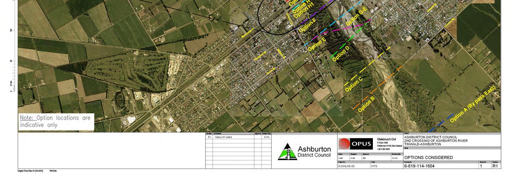
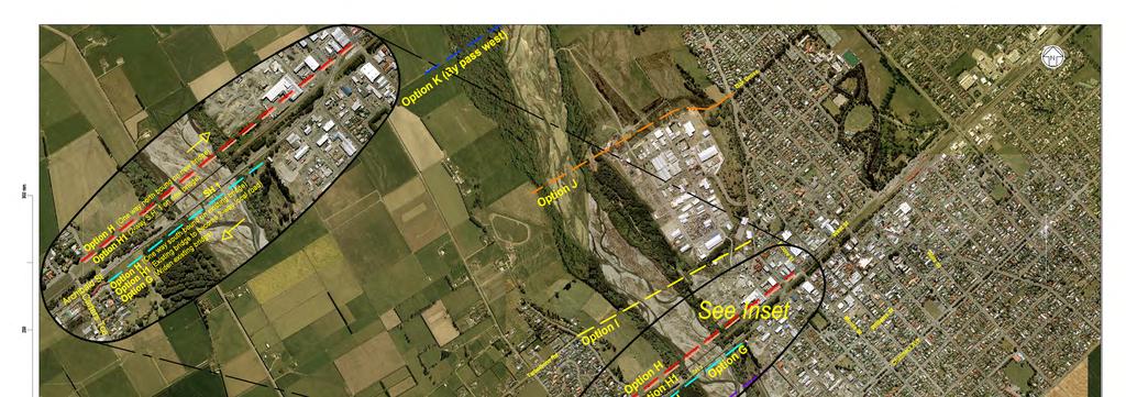
77
78

79
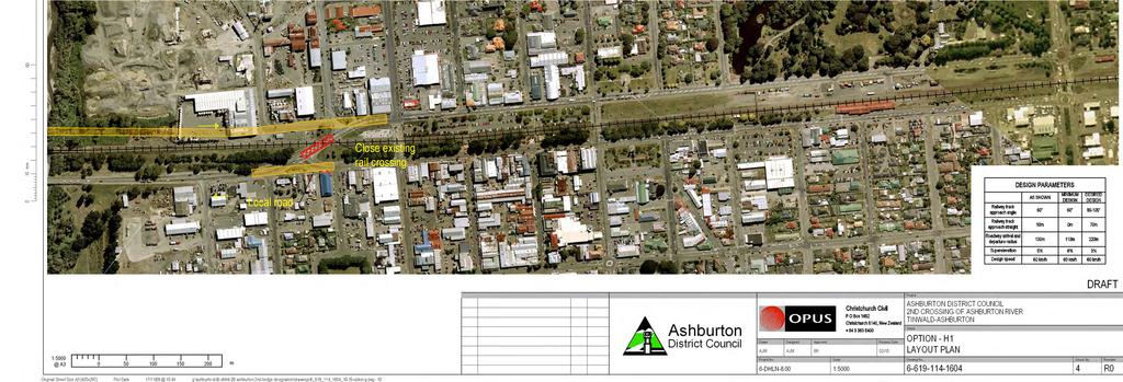
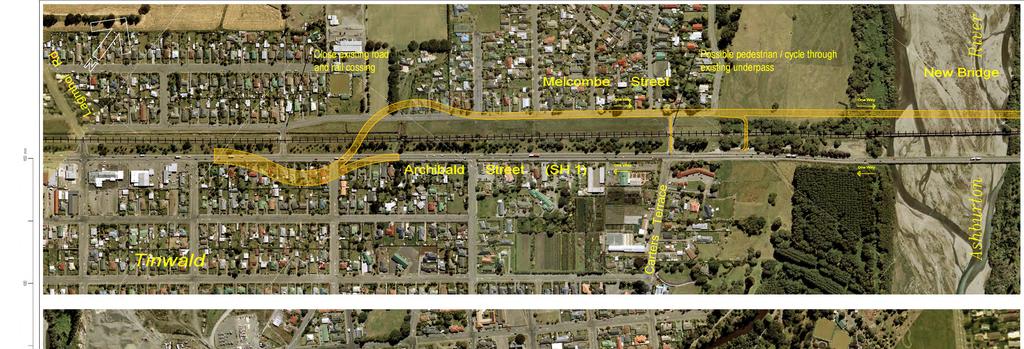
80
81 A m OPTION ALIGNMENT LAYOUTS
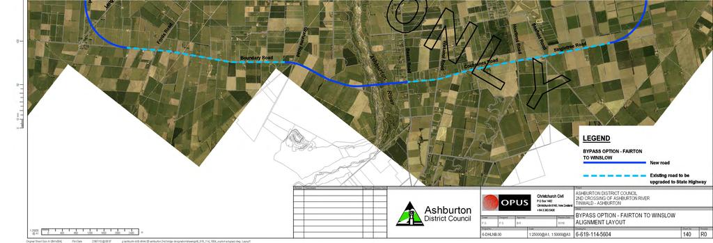

82


83
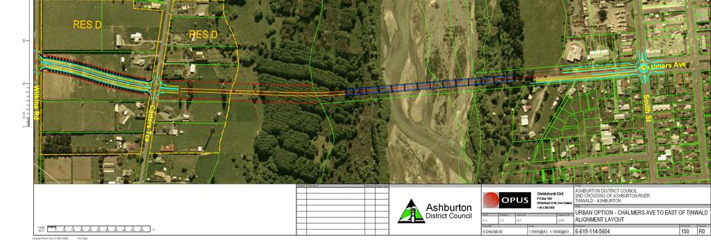
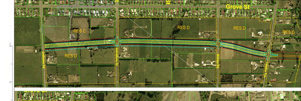
84

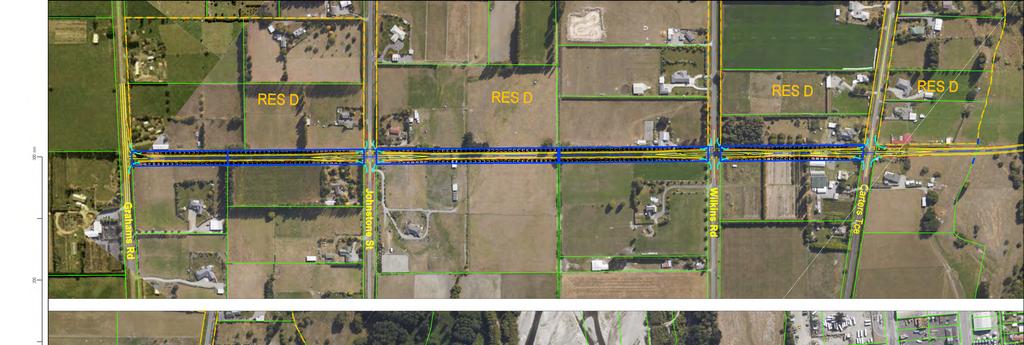
85


86

87

88
PAEKĀKĀRIKI HILL ROAD / BEACH ROAD / SH1 INTERSECTION PROGRESS REPORT
 Chairperson and Committee Members ENVIRONMENT AND COMMUNITY DEVELOPMENT COMMITTEE 6 DECEMBER 2011 Meeting Status: Public Purpose of Report: For Decision PAEKĀKĀRIKI HILL ROAD / BEACH ROAD / SH1 INTERSECTION
DUNBOW ROAD FUNCTIONAL PLANNING
 DUNBOW ROAD FUNCTIONAL PLANNING Final Report August 3, 216 #31, 316 5th Avenue NE Calgary, AB T2A 6K4 Phone: 43.273.91 Fax: 43.273.344 wattconsultinggroup.com Dunbow Road Functional Planning Final Report
SH1, Karo Drive Wellington Crash Reduction Study
 SH1, Karo Drive Wellington Crash Reduction Study A REPORT PREPARED FOR New Zealand Transport Agency Reference: 12334 January 2013 Hawke s Bay office: PO Box 28 208, Havelock North 4157 Tel: (06) 877 8040
SCHEME DESIGN AND ENGINEERING
 THE NORTH SOMERSET COUNCIL (SOUTH BRISTOL LINK CLASSIFIED ROAD) SIDE ROADS ORDER 2013 THE NORTH SOMERSET COUNCIL (SOUTH BRISTOL LINK) COMPULSORY PURCHASE ORDER 2013 THE NORTH SOMERSET COUNCIL (SOUTH BRISTOL
Cycle traffic and the Strategic Road Network. Sandra Brown, Team Leader, Safer Roads- Design
 Cycle traffic and the Strategic Road Network Sandra Brown, Team Leader, Safer Roads- Design Highways England A Government owned Strategic Highways Company Department for Transport Road Investment Strategy
Welcome to the Open House
 Leslie Street Between 19 th Avenue and Stouffville Road Addendum to Class Environmental Assessment Study Welcome to the Open House Please sign in at the front desk. March 28, 2017 Richmond Green Sports
Update June 2018 OUR 2017 PUBLIC ENGAGEMENT
 Update June 2018 Hi, Let s Get Wellington Moving (LGWM) is developing a Recommended Programme of Investment (RPI) that meets our programme objectives and supports the city s and region s growth. As part
SH1 Western Belfast Bypass Transportation Assessment
 SH1 Western Belfast Bypass Transportation Assessment WBB- Transportation Assessment i This report has been prepared on behalf of the NZ Transport Agency (NZTA). No liability is accepted by this company
2. Context. Existing framework. The context. The challenge. Transport Strategy
 Transport Strategy Providing quality connections Contents 1. Introduction 2. Context 3. Long-term direction 4. Three-year priorities 5. Strategy tree Wellington City Council July 2006 1. Introduction Wellington
North West Non-Technical Summary of the Transport Assessment September 2011
 North West Non-Technical Summary of the Transport Assessment September 2011 Introduction This is a Non-Technical Summary of the findings of the Transport assessment work undertaken for the proposed North
Response to further information request Ministry of Education Notice of Requirement (200 & 252 Park Estate Road)
") 21 Pitt Street PO Box 6345, Auckland 1141, New Zealand T: +64 9 300 9000 // F: +64 9 300 9300 E: info@beca.com // www.beca.com Auckland Council Private Bag 92300 Victoria Street West Auckland 1142 15 August
21 Pitt Street PO Box 6345, Auckland 1141, New Zealand T: +64 9 300 9000 // F: +64 9 300 9300 E: info@beca.com // www.beca.com Auckland Council Private Bag 92300 Victoria Street West Auckland 1142 15 August
Ministry of Education Flat Bush School Notice of Requirement. Integrated Transportation Assessment Report. February 2016
 Ministry of Education Flat Bush School Notice of Requirement Integrated Transportation Assessment Report February 2016 TDG Ref: 12988-2 151105 ita flat bush.docx Ministry of Education Flat Bush School
WELCOME TO OPEN HOUSE # 1 June 14, 2017
 Langstaff Road Weston Road to Highway 7 Class Environmental Assessment Study WELCOME TO OPEN HOUSE # 1 June 14, 2017 Please sign in and join our mailing list Purpose of Open House #1 & Study Area York
CITY OF OTTAWA ROADWAY MODIFICATION APPROVAL UNDER DELEGATED AUTHORITY
 RMA-2015-ATM-038 CITY OF OTTAWA ROADWAY MODIFICATION APPROVAL UNDER DELEGATED AUTHORITY DATE: April 22, 2015 SUBJECT Approval of Roadway Modifications Recommended through an Area Traffic Management Study
This objective implies that all population groups should find walking appealing, and that it is made easier for them to walk more on a daily basis.
 Walking for life The Norwegian Walking Strategy Guro Berge Norwegian public Roads Administration "Walking for life" is the slogan for the National Walking Strategy that is now being formulated in Norway.
ONE SIZE DOESN T FIT ALL RECONCILING OVERLAPPING TRANSPORT NETWORKS IN A CONSTRAINED URBAN ENVIRONMENT
 One Size Doesn t Fit All S Corbett, C Chenery Page 1 ONE SIZE DOESN T FIT ALL RECONCILING OVERLAPPING TRANSPORT NETWORKS IN A CONSTRAINED URBAN ENVIRONMENT Authors/Presenters: Sam Corbett, Principal Transport
Community engagement guide May 2018
 Community engagement guide May 2018 Greater Wellington Regional Council (GWRC), Hutt City Council (HCC) and the New Zealand Transport Agency (NZTA) are working together to achieve some big improvements
6. BREENS/GARDINERS/HAREWOOD INTERSECTION - SAFETY IMPROVEMENT PROJECT
 6. BREENS/GARDINERS/HAREWOOD INTERSECTION - SAFETY IMPROVEMENT PROJECT General Manager responsible: Officer responsible: Author: Jane Parfitt General Manager City Environment DDI 941 8656 Michael Aitken
City of Perth Cycle Plan 2029
 Bicycling Western Australia s response City of Perth Cycle Plan 2029 2012-2021 More People Cycling More Often ABOUT BICYCLING WESTERN AUSTRALIA Bicycling Western Australia is a community based, not-for-profit
TRAFFIC IMPACT STUDY CRITERIA
 Chapter 6 - TRAFFIC IMPACT STUDY CRITERIA 6.1 GENERAL PROVISIONS 6.1.1. Purpose: The purpose of this document is to outline a standard format for preparing a traffic impact study in the City of Steamboat
5 REQUEST FOR GRADE-SEPARATED PEDESTRIAN UNDERPASS CROSSINGS OF LESLIE STREET AND ST. JOHN S SIDEROAD TOWN OF AURORA
 5 REQUEST FOR GRADE-SEPARATED PEDESTRIAN UNDERPASS CROSSINGS OF LESLIE STREET AND ST. JOHN S SIDEROAD TOWN OF AURORA The Transportation Services Committee recommends the adoption of the recommendations
MILTON ROAD LLF PROJECT UPDATE
 Greater Cambridge City Deal MILTON ROAD LLF PROJECT UPDATE 9 th May 2017 Project objectives Comprehensive priority for buses in both directions wherever practicable; Additional capacity for sustainable
Bus and Transit Lane Review Update
 Board Meeting / 25 February 2013 Agenda Item no.8(i) Bus and Transit Lane Review Update Glossary Auckland Transport New Zealand Transport Agency Transit Two Transit Three (AT) (NZTA) (T2) (T3) Executive
Hastings District Council. Whakatu Arterial Link Transportation Assessment
 Hastings District Council Whakatu Arterial Link Transportation Assessment June 2014 Executive summary This report is subject to, and must be read in conjunction with, the limitations set out in Section
Chapter 4 Traffic Analysis
 Chapter 4 Traffic Analysis PURPOSE The traffic analysis component of the K-68 Corridor Management Plan incorporates information on the existing transportation network, such as traffic volumes and intersection
York Scarborough Bridge Economic Appraisal Update Technical Note
 York Scarborough Bridge Economic Appraisal Update Technical Note Specification No. 1 Client name West Yorkshire Combined Authority Client reference M088 Discipline Transportation Project name CCAG2 Economics
Appendix B Transportation Report
 Project File Report Appendix B Transportation Report Town of Whitby HMM Project No. 327878 Final Report October 2014 Revision and Version Tracking CP Rail Crossing at New Coronation Road Class EA Study
8 PROPOSED ROUNDABOUT DUFFERIN STREET AND KING VAUGHAN ROAD INTERSECTION CITY OF VAUGHAN
 8 PROPOSED ROUNDABOUT DUFFERIN STREET AND KING VAUGHAN ROAD INTERSECTION CITY OF VAUGHAN The Transportation Services Committee recommends the adoption of the recommendation contained in the following report
Appendix A. Road Classification Review of Outstanding Issues and Proposed Classifications (All Wards) Staff Report Road Classification System
 Staff Report Road Classification System") Appendix A Road Classification Review of Outstanding Issues and Proposed Classifications (All Wards) Staff Report 2000 A.1 of A.10 A.2 of A.10 STAFF REPORT January 26, 2000 To: From: Works Committee Barry
Appendix A Road Classification Review of Outstanding Issues and Proposed Classifications (All Wards) Staff Report 2000 A.1 of A.10 A.2 of A.10 STAFF REPORT January 26, 2000 To: From: Works Committee Barry
WHANGAREI IMPROVEMENTS
 WHANGAREI IMPROVEMENTS PROJECT OVERVIEW The NZ Transport Agency (NZTA) is working with Whangarei District Council (WDC) to improve the state highway through Whangarei. In addition to the recently completed
1 VicRoads Access Management Policies May 2006 Ver VicRoads Access Management Policies May 2006 Version 1.02
 1 VicRoads Access Management Policies May 2006 Ver 1.02 VicRoads Access Management Policies May 2006 Version 1.02 2 VicRoads Access Management Policies May 2006 Ver 1.02 FOREWORD FOR ACCESS MANAGEMENT
General Design Factors
 Chapter 3: 3-1.0 Introduction General Design Factors Mn/DOT s goals include encouraging and accommodating safe bicycling. From a design perspective, these goals are achieved by first having an understanding
Tonight is an opportunity to learn about the Study and ask questions of the Study Team members.
 Exhibit 1 Welcome Second Open House Tonight is an opportunity to learn about the Study and ask questions of the Study Team members. A first Public Open House was held on September 18th, 2013 which presented
Chapter 7. Transportation. Transportation Road Network Plan Transit Cyclists Pedestrians Multi-Use and Equestrian Trails
 Chapter 7 Transportation Transportation Road Network Plan Transit Cyclists Pedestrians Multi-Use and Equestrian Trails 7.1 TRANSPORTATION BACKGROUND The District of Maple Ridge faces a number of unique
ENFIELD TOWN THE REVISED DESIGN
 TOWN THE REVISED DESIGN We re turning Enfield into a borough that encourages walking and cycling, a place that s easy for all of us to get around however we choose to travel. A greener place, with safer
Corporate. Report COUNCIL DATE: June 26, 2006 NO: C012 COUNCIL-IN-COMMITTEE. TO: Mayor & Council DATE: June 22, 2006
 Corporate NO: C012 Report COUNCIL DATE: June 26, 2006 COUNCIL-IN-COMMITTEE TO: Mayor & Council DATE: June 22, 2006 FROM: General Manager, Engineering FILE: 0410-20(MoT/Gate) SUBJECT: Surrey Response on
New Seward and 36 th Avenue Intersection Conceptual Design
 University of Alaska Anchorage New Seward and 36 th Avenue Intersection Conceptual Design Prepared By: Zaid S. Hussein Dana Menendez Galen Jones Civil Engineering Department Prof. Osama Abaza CE A404 Highway
Access Management Regulations and Standards
 Access Management Regulations and Standards January 2014 Efficient highway operation Reasonable property access Concept of Access Management The way to manage access to land development while preserving
M6 Junction 10 Public Consultation
 M6 Junction 10 Public Consultation December 2015 Introduction Walsall Council and Highways England are developing plans to provide a long term improvement to M6 junction 10. We are holding this non-statutory
EXECUTIVE SUMMARY OF CALEDON TRANSPORTATION NEEDS STUDY
 EXECUTIVE SUMMARY OF CALEDON TRANSPORTATION NEEDS STUDY The Caledon Transportation Needs Study has been undertaken as a joint project by the Town of Caledon and the Region of Peel to determine the existing
BETHEL ROAD AND SEDGWICK ROAD CORRIDOR STUDY
 DRAFT PLAN City Council Meeting August 14, 2017 STUDY AREA Sedgwick Corridor State Route 160, principal arterial with Class 3 access management designation, commuter and freight route, connection to SR
Transport Assessment. Curtis Street Plan Change
 Transport Assessment Curtis Street Plan Change Transport Assessment for Curtis Street Plan Change i Contents 1. Introduction... 1 2. Existing Conditions... 2 2.1 Location... 2 2.2 Study Area... 3 2.3
TRAFFIC STUDY GUIDELINES Clarksville Street Department
 TRAFFIC STUDY GUIDELINES Clarksville Street Department 9/1/2009 Introduction Traffic studies are used to help the city determine potential impacts to the operation of the surrounding roadway network. Two
5. The speed camera site outside the Parkwood Rest Home opposite Linwood College is a valuable deterrent. The speed camera site should be retained.
 27. ALDWINS ROAD SPEED LIMIT General Manager responsible: General Manager City Environment, DDI 941-8656 Officer responsible: Author: PURPOSE OF THE REPORT Unit Manager, Transport and Greenspace Brian
March Maidstone Integrated Transport Strategy Boxley Parish Council Briefing Note. Context. Author: Parish Clerk 2 March 2016
 Context. Author: Parish Clerk 2 The Draft Integrated Transport Policy (DITS) sets out a vision and objectives, and identifies a detailed programme of interventions to support the Maidstone Borough Local
A127/A130 Fairglen Interchange Improvement Schemes. Information Leaflet February 2017
 A127/A130 Fairglen Interchange Improvement Schemes Information Leaflet February 2017 1 2 Foreword By Councillor Kevin Bentley Essex is continuing to grow as a vibrant economic hub and as a fantastic place
Douglas Land Use and Transportation Strategy (DLUTS) Summary. August 2013
 Summary. August 2013") Douglas Land Use and Transportation Strategy (DLUTS) Summary August 2013 Background Douglas is a large and popular residential suburb of approximately 30,000 persons on the periphery of Cork City along
Douglas Land Use and Transportation Strategy (DLUTS) Summary August 2013 Background Douglas is a large and popular residential suburb of approximately 30,000 persons on the periphery of Cork City along
APPENDIX 2 LAKESHORE ROAD TRANSPORTATION REVIEW STUDY EXECUTIVE SUMMARY
 APPENDIX 2 LAKESHORE ROAD TRANSPORTATION REVIEW STUDY EXECUTIVE SUMMARY Appendix 2 City of Mississauga Lakeshore Road FINAL REPORT Transportation Review Study December 2010 EXECUTIVE SUMMARY Study Purpose
PROPOSED RESIDENTIAL SUBDIVISION
 PROPOSED RESIDENTIAL SUBDIVISION PART OF TARNEIT ROAD & 1121 DOHERTYS ROAD, TARNEIT Prepared For: TCG (RM) Developments Pty Ltd MARCH 2014 OUR REF: 16740R#1 PROPOSED RESIDENTIAL SUBDIVISION PART OF TARNEIT
Speed Limit Policy Isle of Wight Council
 APPENDIX B Speed Limit Policy Isle of Wight Council 2009 Contents Section 1 Introduction 1.1 Links with the Local Transport Plan Section 2 Speed Limits on Urban Roads and Residential Areas 2.1 20mph Limits
C.A.R.S. Project Design Report.
 C.A.R.S. Project Design Report. PRODUCED BY: Browne, A. Kennedy, M. Dolan, N. Selman, C. STUDENT NO: DATE DUE: COURSE: LECTURER: C09365788-C09686908-D11125480-C08868352 20-April-2012 Dt004/3 Civil Engineering
Welcome! San Jose Avenue Open House August 25, 2015
 Welcome! San Jose Avenue Open House August 25, 2015 Vision Zero The City and County of San Francisco adopted Vision Zero San Francisco Vision Zero High Injury Network as a policy in 2014, committing an
HENDERSON DEVELOPMENT 213, 217, 221, 221 ½, 223 HENDERSON AVENUE and 65 TEMPLETON STREET OTTAWA, ONTARIO TRANSPORTATION OVERVIEW.
 HENDERSON DEVELOPMENT 213, 217, 221, 221 ½, 223 HENDERSON AVENUE and 65 TEMPLETON STREET OTTAWA, ONTARIO TRANSPORTATION OVERVIEW Prepared for: 2294170 Ontario Inc. February 2, 2017 117-652 Report_1.doc
Cycle Routes. Traffic Advisory Leaflet 3/95 March Introduction. Implementation. Project aims. Design
 Traffic Advisory Leaflet 3/95 March 1995 Cycle Routes Introduction The leaflet summarises the findings of the Cycle Routes Programme. This research was undertaken for the Department of Transport by the
TRANSPORTATION NEEDS ASSESSMENT
 TRANSPORTATION NEEDS ASSESSMENT A travel demand analysis was carried out to determine the operational issues and the potential benefit that adding traffic capacity would have on the road network. All the
DYNAMIC LANES FOR AUCKLAND
 Dynamic Lanes for Auckland MENEZES M. and INMAN R. Page 1 DYNAMIC LANES FOR AUCKLAND Authors: INMAN, Robert BA (Hons) Previously Auckland Transport Senior Traffic Engineer Now Aurecon Robert.Inman@aurecongroup.com
Exhibit 1 PLANNING COMMISSION AGENDA ITEM
 Exhibit 1 PLANNING COMMISSION AGENDA ITEM Project Name: Grand Junction Circulation Plan Grand Junction Complete Streets Policy Applicant: City of Grand Junction Representative: David Thornton Address:
Operational Comparison of Transit Signal Priority Strategies
 Operational Comparison of Transit Signal Priority Strategies Revision Submitted on: November, 0 Author: Adriana Rodriguez, E.I Assistant Engineer Parsons Brinckerhoff 0 South Orange Avenue, Suite 00 Orlando,
POLICY: TRAFFIC CALMING
 2006 MAY REFERENCE: COUNCIL APPROVED BY COUNCIL MAY 23, 2006 CITY OPERATIONS - NO. 608 POLICY: TRAFFIC CALMING A. All requests for traffic calming within the City shall be considered in accordance with
TRAFFIC SIGNALS OR ROUNDABOUT AT THIS UNUSUAL INTERSECTION?
 TRAFFIC SIGNALS OR ROUNDABOUT AT THIS UNUSUAL INTERSECTION? Presenting Author Phil Weber, P.Eng. GHD Inc. (The Home of Ourston Engineering) 11 Allstate Parkway, Suite 310 Markham, ON L3R 9T8 Phone (905)
14. PROPOSED PEDESTRIAN CROSSING IMPROVEMENTS IN MOORHOUSE AVENUE
 165 14. PROPOSED PEDESTRIAN CROSSING IMPROVEMENTS IN MOORHOUSE AVENUE General Manager responsible: General Manager City Environment, DDI 941-8528 Officer responsible: Transport and Greenspace Unit Manager
At each type of conflict location, the risk is affected by certain parameters:
 TN001 April 2016 The separated cycleway options tool (SCOT) was developed to partially address some of the gaps identified in Stage 1 of the Cycling Network Guidance project relating to separated cycleways.
Complete Street Analysis of a Road Diet: Orange Grove Boulevard, Pasadena, CA
 Complete Street Analysis of a Road Diet: Orange Grove Boulevard, Pasadena, CA Aaron Elias, Bill Cisco Abstract As part of evaluating the feasibility of a road diet on Orange Grove Boulevard in Pasadena,
Cork to Limerick Route Pre-Feasibility Study Update
 Cork to Limerick Route Pre-Feasibility Study Update November 2008 Document Title: Cork to Limerick Route Pre-Feasibility Study Update Document Ref(s). : Date Rev Status Originator Checked Approved 01/12/08
Improving Cyclist Safety at the Dundas Street West and Sterling Road Intersection
 STAFF REPORT ACTION REQUIRED Improving Cyclist Safety at the Dundas Street West and Sterling Road Intersection Date: August 17, 2012 To: From: Wards: Reference Number: Public Works and Infrastructure Committee
City of Homewood Transportation Plan
 City of Homewood Transportation Plan Prepared for: City of Homewood, Alabama Prepared by: Skipper Consulting, Inc. May 2007 TABLE OF CONTENTS INTRODUCTION... 1 BACKGROUND INFORMATION... 1 EXISTING TRANSPORTATION
A5.1 Permitted activities
 Section A5 Transportation A5.1 Permitted activities A5.1.1 Activities within roads Note: Refer to Section D for the definition of road (a) Any activity associated with the movement of traffic and the functioning
NEW YORK CENTRAL PARK SUBDIVISION BLAIS STREET/ST-PIERRE STREET EMBRUN, ONTARIO TRAFFIC IMPACT STUDY. Prepared for:
 NEW YORK CENTRAL PARK SUBDIVISION BLAIS STREET/ST-PIERRE STREET EMBRUN, ONTARIO TRAFFIC IMPACT STUDY Prepared for: Solidex Holdings Limited & Investissement Maurice Lemieux Investments Attn: Mr. Anthony
Wicklow County Council Chomairle Chontae Chill Mhantáin. Traffic Calming Policy
 Chomairle Chontae Chill Mhantáin Adopted by Wicklow County Council on the 11th of June, 2012 Contents Section Page 1. Introduction 3 2. Legislation 3 3. Guidance Documentation 3 4. Policy Objectives &
Wellington Public Transport Spine Study
 Wellington Public Transport Spine Study Study purpose Feasibility study Options for a high quality, high frequency PT system Key action from Ngauranga to Airport Corridor Plan (2008) Long-term outlook
NRA New Divided Road Types: Type 2 and Type 3 Dual - Carriageways
 NRA New Divided Road Types: Type 2 and Type 3 Dual - Carriageways DN-GEO-03059 December 2007 DN Design Technical TRANSPORT INFRASTRUCTURE IRELAND (TII) PUBLICATIONS About TII Transport Infrastructure Ireland
9. Parking Supporting Statement
 9. Parking Supporting Statement Content 1. Setting the Scene 2. Vision 3. Parking and the Shared Priorities 4. Issues 5. Delivery Programme in the first Plan Period 2001/02 2005/06 6. Good Practice 7.
Bristol City Council has produced a draft Bristol Transport Strategy document.
 Bristol Transport Strategy Summary Document Introduction Bristol City Council has produced a draft Bristol Transport Strategy document. The Strategy fills a gap in transport policy for Bristol. We have
MUTCD Part 6G: Type of Temporary Traffic Control Zone Activities
 MUTCD Part 6G: Type of Temporary Traffic Control Zone Activities 6G.01 Typical Applications Each temporary traffic control (TTC) zone is different. Many variables, such as location of work, highway type,
Highway 49, Highway 351 and Highway 91 Improvements Feasibility Study Craighead County
 Highway 49, Highway 351 and Highway 91 Improvements Feasibility Study Craighead County Executive Summary March 2015 Highway 49, Highway 351 and Highway 91 Improvements Feasibility Study Craighead County
Circulation in Elk Grove includes: Motor vehicles, including cars and trucks
 Circulation, as it is used in this General Plan, refers to the many ways people and goods move from place to place in Elk Grove and the region. Circulation in Elk Grove includes: Motor vehicles, including
JONESBORO HIGHWAY 63 HIGHWAY 18 CONNECTOR STUDY
 JONESBORO HIGHWAY 63 HIGHWAY 18 CONNECTOR STUDY Craighead County May 2007 JONESBORO HIGHWAY 63 HIGHWAY 18 CONNECTOR STUDY Craighead County May 2007 Prepared by Planning and Research Division Arkansas State
CITY OF HAMILTON PLANNING AND ECONOMIC DEVELOPMENT DEPARTMENT Transportation Planning and Parking Division
 CITY OF HAMILTON PLANNING AND ECONOMIC DEVELOPMENT DEPARTMENT Transportation Planning and Parking Division TO: Chair and Members Public Works Committee COMMITTEE DATE: June 18, 2018 SUBJECT/REPORT NO:
3 TRAFFIC CONTROL SIGNAL TIMING AND SYNCHRONIZATION
 Report No. 8 of the Transportation Services Committee Regional Council Meeting of October 20, 2011 3 TRAFFIC CONTROL SIGNAL TIMING AND SYNCHRONIZATION The Transportation Services Committee recommends:
INNER LOOP EAST. AIA Rochester Annual Meeting November 13, 2013 TRANSFORMATION PROJECT. Bret Garwood, NBD Erik Frisch, DES
 INNER LOOP EAST TRANSFORMATION PROJECT AIA Rochester Annual Meeting November 13, 2013 Bret Garwood, NBD Erik Frisch, DES Why? We are building a city that encourages walking, biking and enjoying the outdoor
Southwest Bus Rapid Transit (SW BRT) Functional Planning Study - Executive Summary January 19 LPT ATTACHMENT 2.
 Functional Planning Study - Executive Summary January 19 LPT ATTACHMENT 2.") Southwest Bus Rapid Transit (SW BRT) Functional Planning Study - Executive Summary 2011 January 19 1 of 19 Introduction This executive summary presents the results of the Southwest Bus Rapid Transit (SW
Southwest Bus Rapid Transit (SW BRT) Functional Planning Study - Executive Summary 2011 January 19 1 of 19 Introduction This executive summary presents the results of the Southwest Bus Rapid Transit (SW
Berwick Health and Education Precinct: Casey Amendment C207 (Part 1) Submission to Planning Panels Victoria
 Submission to Planning Panels Victoria") Berwick Health and Education Precinct: Casey Amendment C207 (Part 1) Submission to Planning Panels Victoria August 2018 CONTENTS 1 Executive summary... 1 2 Summary of the amendment... 2 3 Submission...
Berwick Health and Education Precinct: Casey Amendment C207 (Part 1) Submission to Planning Panels Victoria August 2018 CONTENTS 1 Executive summary... 1 2 Summary of the amendment... 2 3 Submission...
Preliminary Transportation Analysis
 Preliminary Transportation Analysis Goals of a Robust, Multimodal Transportation Network Safe Accessible/Connected Efficient Comfortable Context-Sensitive Motor Vehicle: Continue to analyze the data to
Shotover Country. Proposed Private Plan Change. Transportation Assessment Report. February 2010
 Shotover Country Proposed Private Plan Change February 2010 PO Box 13 835, Armagh Christchurch 8141 P: +64 3 379 2404 www.tdg.co.nz New Zealand Shotover Country Proposed Private Plan Change Quality Assurance
Auckland Transport s responses to feedback on proposed upgrades to the intersection of Mercari way and Don Mckinnon Drive
 s to feedback on proposed upgrades to the intersection of way and Don Mckinnon Drive Points raised through feedback process 1 Congestion The proposal will improve traffic flow through the intersection
Transportation Master Plan Advisory Task Force
 Transportation Master Plan Advisory Task Force Network Alternatives & Phasing Strategy February 2016 BACKGROUND Table of Contents BACKGROUND Purpose & Introduction 2 Linking the TMP to Key Council Approved
Classification Criteria
 SCHEDULE D TO RECOMMENDED OFFICIAL PLAN AMENDMENT NO. 40 SCHEDULE C-4 Road Criteria Criteria Traffic Service Objective Land Service/Access Typical Daily Traffic Volume Flow characteristics Travel Speed
CITY OF SAINT JOHN TRAFFIC CALMING POLICY
 CITY OF SAINT JOHN TRAFFIC CALMING POLICY VERSION: 1.0 April 10, 2012 Pedestrians, Cyclists and Motorists Sharing Street Spaces CONTENTS INTRODUCTION... 3 POLICY GOAL... 3 POLICY OBJECTIVES... 3 GUIDING
Solana Beach Comprehensive Active Transportation Strategy (CATS)
") Solana Beach Comprehensive Active Transportation Strategy (CATS) 3.0 Goals & Policies The Solana Beach CATS goals and objectives outlined below were largely drawn from the Solana Beach Circulation Element
Solana Beach Comprehensive Active Transportation Strategy (CATS) 3.0 Goals & Policies The Solana Beach CATS goals and objectives outlined below were largely drawn from the Solana Beach Circulation Element
Integrated Transport Assessment
 AUCKLAND REGIONAL TRANSPORT AUTHORITY Integrated Transport Assessment Guidelines Integrated Transport Assessment & Supplementary Documents Guidelines & Supplementary Documents - October 2007 Integrated
Launceston's Transport Futures. Greater travel options for the people of Launceston
 Launceston's Transport Futures Greater travel options for the people of Launceston Final Draft 13 Jan 2014 1 Page Number Executive summary 3 What is Transport Futures? 4 Vision 6 Economy, access and liveability
Seal Extension Guidelines. Asset Management and Systems
 Seal Extension Guidelines 1. Guideline Definitions AADT - Annual Average Daily Traffic is measured at regular annual (or greater) intervals and adjusted for seasonal effects, using an approved traffic
Corporate. Report COUNCIL DATE: May 25, 1998 NO: R1500 REGULAR COUNCIL. TO: Mayor & Council DATE: April 27, 1998
 R1500 : Traffic Safety at 25 Avenue and 128 Street Intersection Corporate NO: R1500 Report COUNCIL DATE: May 25, 1998 REGULAR COUNCIL TO: Mayor & Council DATE: April 27, 1998 FROM: General Manager, Engineering
DRAFT BUENA VISTA 2020 TRANSPORTATION PLAN
 DRAFT BUENA VISTA 2020 TRANSPORTATION PLAN DEVELOPED BY THE TRANSPORTATION PLANNING DIVISION OF THE VIRGINIA DEPARTMENT OF TRANSPORTATION IN COOPERATION WITH THE U.S. DEPARTMENT OF TRANSPORTATION, FEDERAL
DRAFT. DRAFT Transport. Chapter 7 - Transport
 Transport Contents 7.1 Objectives and policies 7.1.1 Objective 1 Integrated transport system 7.1.2 Objective 2 Adverse effects from the transport network 7.2 Rules All zones outside the Central City 7.2.1
Casablanca Boulevard & GO Station Access
 Casablanca Boulevard & GO Station Access Class Environmental Assessment STAKEHOLDER WORKSHOP Thursday September 27th, 2018 5:30PM 8:00PM 1 WORKSHOP PURPOSE Provide an overview of the Design Alternatives
NOTES FROM JUNIOR COUNCIL ORIENTATION SESSION HELD ON MONDAY, JANUARY 22, 2018, AT 3:30 PM IN COUNCIL CHAMBERS, CITY HALL
 CITY OF KAMLOOPS Junior Council Meeting Agenda March 12, 2018, at 3:30 pm in Council Chambers, 7 Victoria Street West, Kamloops, BC Page 1. APPROVAL OF THE AGENDA 2. MINUTES Attachment Recommendation:
21.07 TRANSPORT CONNECTIVITY AND INFRASTRUCTURE
 21.07 TRANSPORT CONNECTIVITY AND INFRASTRUCTURE 21.07-1 Connectivity and Choice Transport connectivity and mode choice are critical to achieving productive, sustainable and socially just cities. Travel
Arterial Management Plan for US Route 250 and State Route 623
 Arterial Management Plan for US Route 250 and State Route 623 June 25, 2014 Brad Shelton, AICP Access Management and Traffic Impact Analysis Programs Manager Transportation and Mobility Planning Division
List of Display Boards
 List of Display Boards Welcome Introduction Municipal Class Environmental Assessment (EA) Process Need and Justification for an Interchange Alternatives for Evaluation Vertical and Horizontal Alignments