MEMORANDUM Ashford Dunwoody Road: Request to waive right of way dedication requirements of Sec
|
|
|
- Valentine Terry
- 5 years ago
- Views:
Transcription

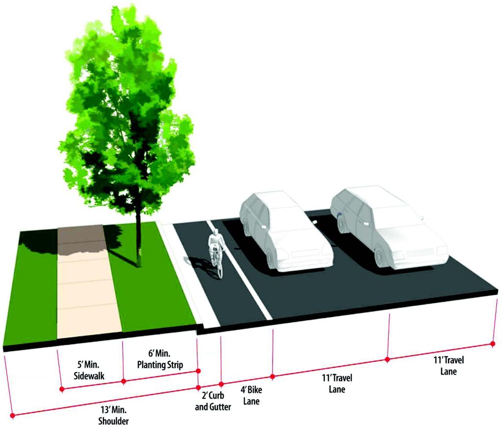
1 MEMORANDUM To: From: Mayor and City Council Michael Smith, Public Works Director Date: October 13, 2014 Subject 4400 Ashford Dunwoody Road: Request to waive right of way dedication requirements of Sec ITEM DESCRIPTION The applicant has submitted for a land disturbance permit to demolish the existing auto service center at Perimeter Mall and build a new Chick-fil-A restaurant (site plan attached). The attached plan shows the site located between two entrances to the mall property on Hammond Drive. The applicant has requested a waiver of the right of way dedication required by Section of the city s code of ordinances. BACKGROUND Development Code Review Code section applies to...streets in subdivisions and in other projects requiring a development or land-disturbance permit from the city. Subsection (j) of states that streets must be designed and constructed in accordance with the regulations of the following table excerpted from the code: Type of Road Arterial and collector streets Travel Bike Lanes Lanes 11 4' Curb and Sidewalks Shoulder [1] Gutter 2 5' 13 [1] Shoulder width includes a minimum six foot planting strip, minimum five foot sidewalk and space for underground utilities (cable, TV, water, telephone, electric and natural gas) Figure 14-2 of the code (attached) provides a visual depiction of the typical street cross section that is required. The requirements are further stated in k.2: For existing streets on which a proposed development or project requiring a land development permit has frontage, the applicant must: a. Dedicate a minimum of 50 percent of the required right of way width as measured from the centerline of the existing street right-of-way; b. Install all required sidewalks, street trees, streetlights, and public utilities in accordance with the standards in subsection (j); and c. Provide a minimum of 50 percent of the roadway pavement required in subsection (j) and install it to the right-of-way centerline.
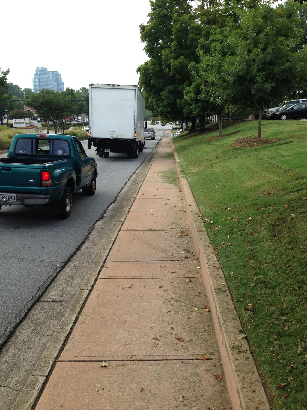
2 Subsection k.5 empowers the Mayor and City Council to waive right of way dedication if existing government plans for the roadway indicate lesser right-of-way would be required for dedication. Basis of Applicant s Request City staff has met and corresponded with the applicant on multiple occasions regarding the required street improvements. The applicant does not control the property adjacent to the right of way that would need to be dedicated and is therefore requesting a waiver. It is the city s understanding that Chick-fil-A is entering into a sub-lease with Macy s who controls a small area surrounding the current building location with rights to use the adjacent parking and drive areas. The property between the sub-lease and easement area and the city right of way is controlled by the mall ownership. Staff Analysis Applicable Plans and Standards In addition to being required by the city s code, the street improvements outlined above are generally consistent with the following conceptual plans applicable to this area of the city: 1. Perimeter Community Improvement Districts (PCIDs) Public Space Standards (figure attached) 2. Concept plans (figure attached) developed specifically for the Hammond Drive corridor by the PCIDs and referenced as a planned project in Dunwoody s Comprehensive Transportation Plan and the PCIDs Livable Communities Initiative (LCI) 2011 Update Though the minimum dimensions of each of the proposed street elements vary in each of these plans, the overall concept for Hammond Drive in the city code and the applicable plans is to accommodate bicycles, and provide a landscape buffer between the roadway and pedestrians. The only element currently present is a sidewalk without a buffer. The addition of bike lanes on Hammond would also be consistent with Sandy Springs draft Bicycle, Pedestrian & Trail Plan which recommends a side-path bicycle facility for Hammond Drive west of the Dunwoody city limits. Existing Site Characteristics The site is located less than 900 feet from the Dunwoody MARTA station which is well within the distance that a typical person would walk or bike to access transit. There are currently no bicycle facilities on Hammond Drive. Along the site frontage, there is an existing sidewalk approximately four feet wide with no landscape buffer and a short wall at the back of the sidewalk (picture attached). The relatively narrow sidewalk placed between a wall and the edge of the vehicle travel lanes is less than ideal for pedestrians, and is not consistent with city or PCIDs goals of creating a pedestrian friendly street environment. Proposed Improvements The applicant has provided a site plan that provides for a sidewalk adjacent to the parking lot with connection to the existing sidewalk along Hammond Drive at either end of the site.
3 At the west end of the site the connection would require steps down to the sidewalk along the street. The benefits of the proposed sidewalk location are that it would provide an ample buffer from the roadway, provide better access into the mall at the west end of the site and allow for some of the existing trees to be preserved. The primary drawback to the proposed location is that it would not be located within public right of way, and thus its continued function as a public facility could not be guaranteed. The applicant has demonstrated that the required bike lane can fit within the existing right of way and has elected to pay a fee in lieu of the bike lane improvement. RECOMMENDATION Staff recommends approval of the applicant s request to waive the requirements for right of way dedication provided that a permanent easement can be secured for the proposed sidewalk adjacent to Hammond Drive. The easement ensures that there will continue to be a sidewalk along Hammond Drive for public use. Otherwise, the existing right of way is not sufficient for construction of a sidewalk, and the other required improvements outlined in Section (j).
4 TRAFFIC CONTROL ARROW CURB & GUTTER STANDARD PARKING QUANTITY ACCESSIBLE PARKING SPACE EXISTING AREA TABULATION: BASED ON SITE ENVELOPE NOT LEASE AREA IMPERVIOUS AREA BUILDING PAD, ASPHALT PAVEMENT, CONCRETE, GRAVEL 0.85 ACRES (76%) PERVIOUS AREA GRASS/LANDSCAPE 0.27 ACRES (24%) TOTAL AREA 1.12 ACRES (100%) PARKING RATIO = 1 SPACE PER 100 SF OF GFA, 5 MINIMUM TOTAL LEASABLE SPACE = 4,864 SF BUILDING PARKING SPACES REQUIRED = 49 STANDARD SPACES PROVIDED = 41 SPACES HANDICAP SPACES PROVIDED = 2 SPACES TOTAL SPACES PROVIDED = 43 ADDITIONAL PARKING SUPPLIED VIA CROSS PARKING AGREEMENTS AS THIS IS A BUILDING LEASE AREA ONLY DIRECTIONAL ARROW DRIVE-THRU GRAPHICS STOP LINE GRAPHIC PAINTED ACCESSIBILITY SYMBOL STANDARD PARKING STALL & STRIPING DETAIL, NEUTRAL AREAS SHALL BE MARKED WITH 4" WIDE STRIPES AT 48" O.C. UNLESS NOTED OTHERWISE. DIRECTIONAL SIGNAGE (REFER TO SIGN PACKAGE FOR MORE DETAILS) ALL SIGNS SHALL CONFORM TO THE "MANUAL ON UNIFORM TRAFFIC CONTROL DEVICES" BY THE U.S. DEPARTMENT OF TRANSPORTATION STRIPED ISLAND CURBED ISLAND CONCRETE SURFACE STANDARD DUTY ASPHALT PAVING HEAVY DUTY ASPHALT PAVING 4" SWSL - 4" WIDE SINGLE WHITE SOLID LINE LIGHT POLE PROPERTY LINE PROPOSED AREA TABULATION: BASED ON SITE ENVELOPE NOT LEASE AREA IMPERVIOUS AREA BUILDING, PAVEMENT, CONCRETE PERVIOUS AREA GRASS/LANDSCAPE 0.82 ACRES (73%, 80% MAX.) 0.30 ACRES (27%), 20% MIN. TOTAL AREA 1.12 ACRES (100%) TOTAL DISTURBED 0.92 ACRES (82%) SITE ZONING: C-1 SETBACKS FRONT (SOUTH) - 50 FEET RIGHT SIDE (EAST) - 50 FEET LEFT SIDE (WEST)- 50 FEET 30 FEET REAR (NORTH) A A 19B A A 6B 6C 6D 6E STOP SIGN (R1-1 30"X30") HANDICAP SIGN DRIVE-THRU SIGN RIGHT TURN ONLY SIGN ONE WAY SIGN (R6-1 OR R6-2) SIDEWALK ACCESSIBLE RAMP CURB RAMP w/ FLARED SIDES CURB RAMP w/ SHORT FLARED SIDES RETURNED CURB ACCESSIBLE RAMP TRUNCATED DOMES (NOT USED) TYPICAL CONCRETE SIDEWALK SIDEWALK WITH CURB & GUTTER SECTION DRIVE-THRU PLAN VIEW DRIVE-THRU ISOMETRIC VIEW SOLID PLASTIC WHEEL STOP LANDSCAPE & IRRIGATION PROTECTOR 6F 6G 6H 6I 6J LEFT TURN ONLY PEDESTRIANS CROSSING EXIT ONLY SIGN DO NOT ENTER SIGN (R5-1) THANK YOU 24" CONCRETE CURB & GUTTER - CATCHING & SPILLING ROLLOVER/MOUNTABLE CURB REFUSE ENCLOSURE FOUNDATION PLAN REFUSE ENCLOSURE FOUNDATION PLAN (ALT) REFUSE ENCLOSURE ALTERNATE DRAINAGE PLAN CONCRETE BOLLARD TYPICAL PAVEMENT SECTION PAVEMENT EDGE DETAIL TRANSVERSE & LONGITUDINAL CONTRACTION JOINT TRANSVERSE & LONGITUDINAL DOWELED CONSTRUCTION JOINT CONCRETE TRASH ENCLOSURE CONCRETE DRIVE THRU LANE 26 ALUMINUM HANDRAIL TYPICAL ADA RAMP AND HANDRAIL CONTRACTION JOINT KEYED CONSTRUCTION JOINT LONGITUDINAL BUTT JOINT EXPANSION JOINT MULTI-ORDER POINT DIRECTIONAL ARROW DETAILS PAVER OR STAMPED CONCRETE CROSSWALK DRIVE-THRU ORDER POINT ISLAND CURB 35 MENU BOARD LOOP DETECTION SYSTEM 36 ENTRY DOOR FROST SLAB DETAIL 37 SAN. C.O. OUTSIDE BUILDING 38 BUILDING DOWNSPOUT CONNECTION DETAIL 39 TYPICAL SECTION AT INLET/CATCH BASIN DETAIL 40 STORM WEEP HOLE DETAIL CHICK-FIL-A SIGN (REFER TO SIGN PACKAGE) PRE-SELL MENU BOARD (NOT USED) 7 8A A 20 21A C B Macy Drive Roswell, GA PH: FAX: O:\Projects\2011\ CFA Perimeter GA (#3049)\deliverables\ C-2.0.dwg Sheet No: C-2.0 Saved by: todd - Monday, September 15, :12 PM Printed by: Todd - September 17, :33 AM MENU BOARD & CANOPY ORDERING STATION (REFER TO SIGN PACKAGE) CHICK-FIL-A "ENTER" SIGN (NOT USED) CHICK-FIL-A "EXIT" SIGN (NOT USED) 50' FLAG POLE (REFER TO SIGN PACKAGE) CLEARANCE BARS (NOT USED) LIGHT POLE & BASE BITUMASTIC EXPANSION JOINT, TYP. INSTALL EXPANSION JOINT BETWEEN ALL CONCRETE PAVEMENT INTERFACE WITH BUILDINGS, CURB & GUTTER, AND OTHER CONSTRAINED OBJECTS, TYPICAL. 50 SITE CONTRACTOR SHALL REFER TO ARCHITECT PLANS FOR THE EXACT DIMENSIONS OF THE BUILDING AND THE LOCATION OF DOORWAYS, UTILITIES, ETC. 51 GATES TO BE INSTALLED BY BUILDING CONTRACTOR WITH DUMPSTER STRUCTURE. COORDINATE WITH PAVEMENT INSTALLATION 52 SAWCUT EXISTING CURB & GUTTER AS NECESSARY TO COMPLETE NEW CURB & GUTTER CONNECTION. PROVIDE EXPANSION JOINT BETWEEN INTERFACE. 53 THE CONTRACTOR SHALL INSTALL NECESSARY TRAFFIC CONTROL, SAFETY BARRICADES, LIGHTING, AND OTHER REQUIRED CONTROL MEASURES TO SECURE THE WORK AREA FROM EXISTING TRAFFIC AND TO ENSURE PUBLIC SAFETY TRANSFORMER PAD SINGLE WHITE SOLID LINE 56 BIKE RACK (SEE DETAIL SHEET)
5
 Existing or planned connection to interstate system Primary connections to")


 Peachtree Dunwoody Road Thoroughfare with median NOTE: *Widths are the desired minimum.")
6 Public Space Standards LIVE.WORK.WALK.PLAY Thoroughfare Primary route for commuters (heavy traffic) Existing or planned connection to interstate system Primary connections to other regions outside of the Perimeter area May have a median Less traveled by pedestrians Bicycle lanes or Share the Road lanes Connections to Shuttle Connector/Bicycle Path Thoroughfare without median Characteristics: Heavy landscaping Tree-lined medians *8 to 10-foot minimum sidewalks separated from travel lanes by *5-foot minimum planting strip Decorative street lights Median lights Pedestrian lights Street trees Fenced Tree Planters Pedestrian signage Bicycle lanes or Share the Road lanes Examples within the PCID: Abernathy Road Ashford Dunwoody Road Perimeter Center West Glennridge Drive Hammond Drive Johnson Ferry Road Mt. Vernon Road (portion) Peachtree Dunwoody Road Thoroughfare with median NOTE: *Widths are the desired minimum. Adjustments to these widths can occur where there are conflicts with utilities, right-of-way or other unforseen challanges. Adjustments will be approved on a case by case basis. Street Types Sections
7 PERIMETER CENTER PARKWAY HIGH STREET MARTA - DUNWOODY STATION PERIMETER MALL PEACHTREE DUNWOODY RD HAMMOND DRIVE ASHFORD-DUNWOODY ROAD PUBLIX CORPORATE CAMPUS 236 PERIMETER MIXED-USE GA 400 CONCOURSE PKWY HAMMOND DRIVE CONCOURSE PKWY CONCOURSE PEACHTREE DUNWOODY RD HAMMOND DRIVE CITY OF SANDY SPRINGS CITY OF DUNWOODY 245 PERIMETER CENTER PERIMETER CENTER PARKWAY GOLDKIST ROAD PERIMETER COMMUNITY IMPROVEMENT DISTRICTS ALTERNATIVE 2 HAMMOND DRIVE CORRIDOR IMPROVEMENTS
8
Roadway Classification Design Standards and Policies. Pueblo, Colorado November, 2004
 Roadway Classification Design Standards and Policies Pueblo, Colorado November, 2004 Table of Contents Page Chapter 1. General Provisions 1.1 Jurisdiction 3 1.2 Purpose and Intent 3 1.3 Modification 3
SECTION 3 STREET DESIGN
 3.01 GENERAL SECTION 3 STREET DESIGN For purposes of geometric and structural design, streets shall be classified according to the following table. The City Engineer will determine the class of all proposed
Item to be Addressed Checklist Consideration YES NO N/A Required Description Complete Streets Guidelines
 Passaic County Complete Streets Checklist - Concept Development Project Name Item to be Addressed Checklist Consideration YES NO N/A Required Description Complete Streets Guidelines Existing Plans Have
Chapter 3 DESIGN SPECIFICATIONS
 Brampton PathWays Planning and Design Guidelines 27 Chapter 3 DESIGN SPECIFICATIONS 3.1 CLASS 1 MULTI-USE PATH Off-road multi-use trails are the backbone of the Brampton PathWays Network. They are typically
ROADWAY AND PARKING DETAILS TYPICAL STREET SECTIONS PRINCIPAL ARTERIAL NOT TO SCALE
 NOTES: O:\Division Information\Engineering\Documents\Engineering and Construction\COMMERCE CITY\CAD files\2016 Updated Files\307-01 thru 307-09 (Roadway & Parking Typical Sections).dwg 6' SIDEWALK MAY
Preparing a Curb Ramp Project. December 15, 2010
 Preparing a Curb Ramp Project December 15, 2010 3 Tiers of Project Types Non-Signalized Curb Ramp Reconstruction - Typically utilizing standard plans and identifying ramp types at each quadrant Signalized
ADA Operations Contact Info
 Intro ADA Operations Contact Info Todd Grugel ph: 651-366-3531 email: todd.grugel@state.mn.us Joe Zilka ph: 651-366-3311 email: joseph.zilka@state.mn.us Harvey Unruh ph: 651-216-2912 email: harvey.unruh@state.mn.us
APPENDIX A: Complete Streets Checklist DRAFT NOVEMBER 2016
 APPENDIX A: Complete Streets Checklist DRAFT NOVEMBER 2016 Complete Streets Checklist MetroPlan Orlando s Complete Streets Checklist is an internal planning tool for staff to further implementation of
Appendix B - Street Sections
 Appendix B - Street Sections 6TH STREET CORRIDOR PLAN STREET SECTIONS The street sections in Appendix B include recommended improvements to streets for North Glenwood. They include existing conditions
Final Sidewalk Feasibility Study
 Garfield Drive From Anastasia Drive to Elizabeth Place City of South Daytona July 23, 2009 Final Sidewalk Feasibility Study Prepared for: Prepared by: Final Sidewalk Feasibility Study Garfield Drive 2
Off-road Trails. Guidance
 Off-road Trails Off-road trails are shared use paths located on an independent alignment that provide two-way travel for people walking, bicycling, and other non-motorized users. Trails specifically along
MAG Town of Cave Creek Bike Study Task 6 Executive Summary and Regional Significance Report
 Page 1 MAG Town of Cave Creek Bike Study Task 6 Executive Summary and Regional Significance Report August 1, 2012 MAG Project #481 Page 2 Task 6 Executive Summary and Regional Significance Report Introduction
ADA Training Standard Plans
 ADA Training Standard Plans SCREEN READABLE VERSION IS IN THE MAKING AND WILL BE MADE AVAILABLE SOON 2018 MnDOT 2 Standard Plans 2017 Overview Overview PROWAG and Curb Ramp Basics Curb Ramp Types ADA Curb
NJDOT Complete Streets Checklist
 Background The New Jersey Department of Transportation s Complete Streets Policy promotes a comprehensive, integrated, connected multi-modal network by providing connections to bicycling and walking trip
This chapter describes the proposed circulation system and transportation alternatives associated with
 5.0 Circulation 5.1 OVERVIEW This chapter describes the proposed circulation system and transportation alternatives associated with West Landing, and summarize the information contained in the Existing
WHEREAS delivery trucks also pass through the Narrows, into the northern parking lot, to loading docks in the back of the building.
 CEDAR-ISLES-DEAN NEIGHBORHOOD ASSOCIATION ( CIDNA ) RESOLUTION OPPOSING A DRUG STORE DRIVE THRU, AND COMMENDING DORAN COMPANIES FOR PROPOSING MITIGATING AMENITIES INCLUDING NEW LANDSCAPING AND A DEDICATED
DRAFT - CITY OF MEDFORD TRANSPORTATION SYSTEM PLAN Roadway Cross-Sections
 Roadway Cross-Sections Medford s roadway cross-section standards apply to new and reconstructed roads. The crosssections take into consideration roadway function and operational characteristics, including
BPP / SUB
 Development Services Department Project/File: Lead Agency: Site address: Millwell Place Subdivision/ BPP15-0031/ SUB15-0064 This is a preliminary plat application to allow for the development of 68 building
2010 STANDARD SPECIFICATIONS STANDARD DRAWINGS
 CITY OF REDMOND, OREGON 2010 STANDARD SPECIFICATIONS STANDARD DRAWINGS TABLE OF CONTENTS SECTION 1 TRENCHES TITLE 1-1 Utility Trench 1-2 Water Line & Sewer Line Separation 1-3 RR X-ING Single/Joint Use
CHAPTER 16 PEDESTRIAN FACILITIES DESIGN AND TECHNICAL CRITERIA TABLE OF CONTENTS
 CHAPTER 16 PEDESTRIAN FACILITIES DESIGN AND TECHNICAL CRITERIA TABLE OF CONTENTS Section Title Page 16.1 General... 16-1 16.1.1 AASHTO Reference... 16-1 16.1.2 ADA Requirements... 16-1 16.2 Sidewalks...
City of Margate, Florida. Neighborhood Traffic Management Manual
 City of Margate, Florida Neighborhood Traffic Management Manual Table of Contents Page No. I. INTRODUCTION... 1 II. TRAFFIC CALMING REQUEST AND PROCESSING PROCEDURES... 2 1. COMPLETE AND SUBMIT PROJECT
Section 7 Complete Green Street Guidelines DRAFT
 Section 7 Complete Green Street Guidelines DRAFT 1 Section: 7.0 COMPLETE GREEN STREET GUIDELINES These guidelines serve as options to mitigate the environmental impact of a project as well as guide the
Driveway Design Criteria
 Design Manual Chapter 5 - Roadway Design 5L - Access Management 5L-4 Driveway Design Criteria A. General For efficient and safe operations, access drives and minor public street intersections can be improved
ACHD Board of Commissioners Stacey Yarrington, Planner III Tandem Ridge/ EPP / PP-07-16/ RZ-12-16/ CPA-01-16/ A-07-16
 Development Services Department DATE: December 14, 2016 TO: FROM: SUBJECT: ACHD Board of Commissioners Stacey Yarrington, Planner III Tandem Ridge/ EPP16-0012/ PP-07-16/ Executive Summary: This is an annexation,
5 CIRCULATION AND STREET DESIGN
 5 CIRCULATION AND STREET DESIGN This chapter describes circulation and streetscape improvements proposed for the Northwest Chico Specific Plan Area. It includes detailed design specifications for existing
RZC Appendix 8A Marymoor Subarea Street Requirements
 RZC Appendix 8A Marymoor Subarea Street Requirements For additional design details for Marymoor Subarea infrastructure, refer to the 2017 Marymoor Subarea Infrastructure Planning Report. STREET REQUIREMENTS
STAKING TRAFFIC CONTROL SIGNAL SYSTEMS
 Locating the components of a traffic control signal is not an exact science; many factors influence the location of the components. These factors include: lane widths, radii, pedestrian curb ramp requirements,
Appendix 3 Roadway and Bike/Ped Design Standards
 Appendix 3 Roadway and Bike/Ped Design Standards OTO Transportation Plan 2040 4/20/2017 Page A3-1 Adopted Standards The adopted OTO Design Standards and Major Thoroughfare Plan are contained herein.
4 GENERIC COST ESTIMATING TOOL
 4 GENERIC COST ESTIMATING TOOL Table 4-1 presents a generic cost estimating tools that can serve as a conceptual planning tool for local jurisdictions to estimate the costs of pedestrian improvements.
Chapter 4: Funding and Implementation
 Chapter 4: Funding and Implementation 83 84 Cost Estimating Cost estimating is an iterative process. When a project is in the conceptual stage, preliminary cost estimates are also provided conceptually,
CHAPTER 8 STAKING SIGNALS AND LIGHTING FIELD GUIDE. 8.1 Staking Traffic Control Signal Systems
 CHAPTER 8 STAKING STAKING Correct staking of traffic control signal or lighting systems is critical to the appropriate placement of system components. 8.1 Traffic Control Signal Systems Locating the components
TRANSPORTATION STANDARDS
 INTRODUCTION LOCAL STREETS ON-STREET PARKING SIDEWALKS STREET LIGHTING STREET FURNISHINGS TRAFFIC CALMING STREET TREES MEDIAN PLANTING BOULEVARD LOCATIONS VILLAGE CENTER STREET LOCATIONS RESIDENTIAL STREET
ADA Design Overview. Section 2. ADA Design Overview. Pedestrian Access Routes. Pedestrian Access Routes. Overview
 ADA Design Overview Section 2 ADA Design Overview Overview Accessible Pedestrian Signals Alternate Fall, 2017 Ann Johnson, PE Services Brady Rutman, SRF Consulting Group 2 Pedestrian Access Route (PAR)
Building Great Neighbourhoods BELLEVUE AND VIRGINIA PARK
 Building Great Neighbourhoods BELLEVUE AND VIRGINIA PARK This is Meeting 2 Unfortunately, some residents in Bellevue and Virginia Park received the wrong information for this public open house (Meeting
CURBSIDE ACTIVITY DESIGN
 5 CURBSIDE ACTIVITY DESIGN This chapter provides design guidance for separated bike lanes adjacent to curbside activities including parking, loading and bus stops. Typical configurations are presented
STEERING COMMITTEE MEETING June 17, Streetscape Overview Burlington Comprehensive Master Plan
 STEERING COMMITTEE MEETING June 17, 2015 Streetscape Overview Burlington Comprehensive Master Plan 1 Introduction Slide This slide show was presented to the Burlington Steering Committee on June 17, 2015
STREETSCAPE CONCEPTS
 STREETSCAPE S CARGO WAY CARGO WAY CYCLE TRACK Streetscape Concepts JENNINGS ST Illustrative Plan EVANS AVE PG&E BAY TRAIL HERON S HEAD PARK The recommended improvements build off the planned improvements
Route 47 (North Main Street) Reconstruction
 Reconstruction") TOWN OF SUNDERLAND Route 47 (North Main Street) Reconstruction Presented by Lou Rabito, P.E. Presented to Town of Sunderland June 11, 2018 Project Overview MassDOT Project No. 607245 Resurfacing and Related
TOWN OF SUNDERLAND Route 47 (North Main Street) Reconstruction Presented by Lou Rabito, P.E. Presented to Town of Sunderland June 11, 2018 Project Overview MassDOT Project No. 607245 Resurfacing and Related
Design Overview. Section 4 Standard Plans for Design. Pedestrian Access Routes. Pedestrian Access Routes. Overview. Cross Slope
 Design Overview Section 4 Standard Plans for Design Fall, 2017 Ann Johnson, PE Services Brady Rutman, SRF Consulting Group Overview Design Basics Recommendations: The Zone System Driveway Crossings Pedestrian
FIRE & LIFE SAFETY STANDARD
 Title: Effective Date: 08/01/2006 Revised Date:01/01/2014 Code References: California Fire Code Note: This standard is a summary of Fire Department clarifications of City and State Codes. Information contained
This Chapter sets forth the minimum design, technical criteria and specifications to be used in the preparation of all roadway plans.
 4.1 GENERAL This Chapter sets forth the minimum design, technical criteria and specifications to be used in the preparation of all roadway plans. These Roadway Standards are for new construction and modification
UDC Street Cross Sections
 UDC Street Cross Sections Local Street - Downtown Local Street Mountable Curb Local Street Vertical Curb Alley Major Arterial Minor Arterial Residential Lane Residential Collector Residential Collector
S T A T I O N A R E A P L A N
 The Circulation and Access Plan describes vehicle, pedestrian, and transit improvements recommended within the Concept Plan. In order to create and sustain a vibrant business district that provides pedestrian-friendly
City of Albert Lea Policy and Procedure Manual 4.10 ALBERT LEA CROSSWALK POLICY
 4.10 ALBERT LEA CROSSWALK POLICY PURPOSE: Pedestrian crosswalks are an integral part of our transportation infrastructure. To be effective and promote safety, marked crosswalks must be installed after
Multimodal Through Corridors and Placemaking Corridors
 68 Multimodal Through Corridors and Placemaking Corridors Corridors have different functions in a region. Some corridors are used to get smoothly and rapidly through a region or to get quickly to major
Brooklyn Boulevard (County Road 152) Reconstruction Project Phase I. OPEN HOUSE June 20, 2017
 Reconstruction Project Phase I. OPEN HOUSE June 20, 2017") Brooklyn Boulevard (County Road 152) Reconstruction Project Phase I OPEN HOUSE June 20, 2017 Brooklyn Boulevard (County Road 152) Phase I Project Partners Project Lead Other Project Partners include Brooklyn
Brooklyn Boulevard (County Road 152) Reconstruction Project Phase I OPEN HOUSE June 20, 2017 Brooklyn Boulevard (County Road 152) Phase I Project Partners Project Lead Other Project Partners include Brooklyn
CITY OF ROSEVILLE DESIGN AND CONSTRUCTION DETAILS
 CITY OF ROSEVILLE DESIGN AND CONSTRUCTION DETAILS Trench Backfill Utility Trench Paving Backfill and Embedment TB 1 HDPE, SRHDPE & PVC Storm Drain Pipe Only (Nonrigid) Bedding and Backfill TB2 Deep Cut
POLICY REVIEW SUMMARY
 E POLICY REVIEW SUMMARY The project team reviewed planning and design standards for each community in the region. The following tables summarize the relevant code in these documents that pertains to the
FOCUS AREA 1 - Alberta Avenue Pocket Park 3 (121 Ave and 92 St)
") FOCUS AREA 1 - Alberta Avenue Pocket Park 3 (121 Ave and 92 St) New benches Plant evergreen trees Widen existing sidewalk from 1.5m to 1.8m Marked crosswalk 1.8m wide sidewalk Add pedestrian oriented lights
FOCUS AREA 1 - Alberta Avenue Pocket Park 3 (121 Ave and 92 St) New benches Plant evergreen trees Widen existing sidewalk from 1.5m to 1.8m Marked crosswalk 1.8m wide sidewalk Add pedestrian oriented lights
Hospital Link Project Project Update September 2017
 Hospital Link Project Project Update September 2017 General The project provides a link from Riverside Drive and the Transitway to the Hospital Link Road. Construction is well underway. Read on for important
WELCOME. City of Eden Prairie West 70 th Street
 WELCOME City of Eden Prairie West 70 th Street Project Schedule Sep Oct Nov Dec Jan Feb Mar Apr May Jun Jul Aug >>> May WEST SEGMENT Concept Plan Fall 2014 Plan Development Winter 2014 Summer 2015 Construction
HILLSBOROUGH COUNTY PUBLIC WORKS TECHNICAL MANUALS AND SPECIFICATIONS 2 YEAR MANDATORY UPDATES (2017) COMMENTS & RESPONSES COMMENT / JUSTIFICATION
 COMMENTS & RESPONSES COMMENT / JUSTIFICATION") Services Division 1 County Staff 1.1 Recommend adding a paragraph advising the EOR/developer that all streets within and contiguous to a proposed development must be coordinated with other existing or
Services Division 1 County Staff 1.1 Recommend adding a paragraph advising the EOR/developer that all streets within and contiguous to a proposed development must be coordinated with other existing or
Designing Pedestrian Facilities for Accessibility. Module 3 Curb Ramps & Blended Transitions
 Module 3 & Other Purpose: Allow pedestrians to transition between the street and sidewalks, islands, etc. Typically installed at: Intersections (1 ramp at each end of each crosswalk) Mid-block crossings
PUBLIC REALM MASTER PLAN
 WESTSHORE BUSINESS DISTRICT PUBLIC REALM MASTER PLAN MASTER PLAN COMMITTEE MEETING MARCH 20, 2013 WESTSHORE BUSINESS DISTRCT PUBLIC REALM MASTER PLAN MACRO-SCALE CONCEPT: A PUBLIC REALM FRAMEWORK DEFINED
Street Paving and Sidewalk Policy
 City Commission Policy 600 Street Paving and Sidewalk Policy DEPARTMENT: Public Works DATE ADOPTED: June 7, 1995 DATE OF LAST REVISION: December 10, 2014 Policy No. 600.01 AUTHORITY: PASS City of Tallahassee-Leon
INDEX. Geometric Design Guide for Canadian Roads INDEX
 Acceleration lane, see Lanes, Acceleration Access, 8.1 Access Management and Functional Classification 8.2 Access Management by Design Classification 8.3 Access Configuration 8.4 Building Set-Back Guidelines
Accommodating Pedestrians in the Work Zone
 Accommodating Pedestrians in the Work Zone Guidance for Section C Plan Preparers Some impacts cannot be avoided and those impacts apply to residents, businesses, motorists, and pedestrians alike. However,
Department of Public Works Office of Disability Affairs February 23, 2017 Presented by Mark Zwoyer, PE
 ADA Ramp Construction Department of Public Works Office of Disability Affairs February 23, 2017 Presented by Mark Zwoyer, PE Agenda Opening Statements/Welcome PROWAG, ADAAG, INDOT and DPW Standards Inspector
Aurora Urban Street Standards For Transit Oriented Developments and Urban Centers
 Aurora Urban Street Standards For Transit Oriented Developments and Urban Centers I. Purpose These standards will be applied to create a safe, comfortable, pleasant and pedestrian-friendly multi-modal
Omaha s Complete Streets Policy
 Omaha s Complete Streets Policy (Adopted August 2015) VISION To create great places and enhance our quality of life, the City of Omaha will provide safe, accessible streets for all users. Complete Streets
DETECTABLE WARNING SURFACES SHALL BE PROVIDED AT THE FOLLOWING LOCATIONS ON PEDESTRIAN ACCESS ROUTES:
 GENERAL NOTES: CURB NOTES: 5'-0" MIN 5'-0" 5'-0" MIN 1. 2. THESE SHEETS ARE IN ACCORDANCE WITH THE AMERICANS WITH DISABILITIES ACT (ADA), AND THE REQUIREMENTS OF THE 2011 PROPOSED ACCESSIBILITY GUIDELINES
1.3 Pedestrian Environments
 SECTION 1: COMMERCIAL DEVELOPMENT 1.3 Pedestrian Environments Design Principle The quality of the pedestrian environment often defines the overall success of a commercial project. Attention to the development
REGIONAL BICYCLE AND PEDESTRIAN DESIGN GUIDELINES
 REGIONAL BICYCLE AND PEDESTRIAN DESIGN GUIDELINES November 16, 2011 Deb Humphreys North Central Texas Council of Governments Bicycle and Pedestrian Advisory Committee Snapshot of the Guide 1. Introduction
CONNECTIVITY PLAN. Adopted December 5, 2017 City of Virginia Beach
 CONNECTIVITY PLAN Adopted December 5, 2017 City of Virginia Beach CONTENTS 1.0 Background & Purpose... 2 2.0 Existing Inventory & Analysis... 3 ViBe District Existing Walking Conditions... 4 3.0 ViBe District
Active Transportation Facility Glossary
 Active Transportation Facility Glossary This document defines different active transportation facilities and suggests appropriate corridor types. Click on a facility type to jump to its definition. Bike
DRAFT. System Components. Greenway Trails. Introduction. Trail Types. Zebulon Greenway Master Plan
 5 System Components Wakefield Street Photo Simulation showing Sharrows Introduction The Master Plan identifies various system components that, together, create a comprehensive greenway system. These components
INDOT Complete Streets Guideline & Policy
 INDOT Complete Streets Guideline & Policy INTRODUCTION The Complete Streets guidelines build upon multiple efforts and promote a multimodal transportation system that is integrated and sustains land use
2017 Temporary traffic control guidelines for pedestrians. v.2
 2017 Temporary traffic control guidelines for pedestrians v.2 Temporary Traffic Control Guidelines for Pedestrians (2017) The safety and mobility of pedestrians, cyclists and motorists must be considered
ADA on Construction. Guidance for Section C Plan Preparers
 ADA on Construction Guidance for Section C Plan Preparers Some impacts cannot be avoided and those impacts apply to residents, businesses, motorists, and pedestrians alike. However, good planning can minimize
Ocean Park Boulevard Green Street Project Alternatives & Trade Offs
 Planning Commission March 4, 2009 Ocean Park Boulevard Green Street Project Alternatives & Trade Offs Purpose of Tonight s Meeting Review concept plans and options Provide input on alternatives and trade-offs
Cycle Track Design Best Practices Cycle Track Sections
 Design Best Practices Sections It is along street segments where the separation and protection methods of cycle tracks offer more comfort than conventional bicycle lanes, and are more attractive to a wide
Town of Siler City - Unified Development Ordinance ARTICLE XIV - Streets and Sidewalks
 ARTICLE XIV - Streets and Sidewalks 193 Street Classification (a) In all new subdivisions, streets that are dedicated to public use shall be classified as provided in 193(b) (1) The classification shall
Mid Rivers Mall Drive Multi-Use Path (Rte. N to MO 364)
") Mid Rivers Mall Drive Multi-Use Path (Rte. N to MO 364) Sponsor St Peters Project No. RB19-000022 Project Type Other TOTAL FUNDING Total County Sponsor Federal $1,177,251.00 $238,179.00 $59,546.00 $879,526.00
Mid Rivers Mall Drive Multi-Use Path (Rte. N to MO 364) Sponsor St Peters Project No. RB19-000022 Project Type Other TOTAL FUNDING Total County Sponsor Federal $1,177,251.00 $238,179.00 $59,546.00 $879,526.00
RC-67M has been updated to include more details to be consistent with both ADAAG and PROWAG. The following slides discusses the general notes found
 RC-67M has been updated to include more details to be consistent with both ADAAG and PROWAG. The following slides discusses the general notes found on Sheet 1. RC-67M note Construct curb ramps with a minimum
David Hung, Associate Planner City of Sacramento Community Development Department 300 Richards Boulevard, 3 rd Floor Sacramento, CA
 June 13, 2016 VIA EMAIL David Hung, Associate Planner City of Sacramento Community Development Department 300 Richards Boulevard, 3 rd Floor Sacramento, CA 959811 RE: Fire Station 14 (DR16-128) Dear Mr.
Ballston Station Multimodal Study WMATA and Arlington County. Meeting Minutes
 Date of Meeting: June 10, 2010 Location: Ballston Metrorail Station and NRECA Building 4301 Wilson Blvd, Arlington, VA Subject: Ballston Station Multimodal Study Stakeholder Meeting #1 Summary: This first
TANGIBLE CAPITAL ASSET (TCA) Reporting Guidelines for Land Development Projects
 Reporting Guidelines for Land Development Projects") January 2012 TANGIBLE CAPITAL ASSET (TCA) Reporting Guidelines for Land Development Projects 1. PURPOSE OF REPORTING The purpose of Tangible Capital Asset (TCA) reporting is to comply with PSAB 3150 reporting
January 2012 TANGIBLE CAPITAL ASSET (TCA) Reporting Guidelines for Land Development Projects 1. PURPOSE OF REPORTING The purpose of Tangible Capital Asset (TCA) reporting is to comply with PSAB 3150 reporting
Complete Streets. Designing Streets for Everyone. Sarnia
 Complete Streets Designing Streets for Everyone Sarnia Complete Streets ~ Sarnia ~ 2018 Introduction Our City is made up of a network of streets that we use to go for a walk, cycle to work, drive to the
APPENDIX G SIGNAGE AND STRIPING SUPPLEMENT
 APPENDIX G SIGNAGE AND STRIPING SUPPLEMENT DOUGLAS COUNTY SIGNAGE AND STRIPING SUPPLEMENT TO DOUGLAS COUNTY ROADWAY DESIGN & CONSTRUCTION STANDARDS UPDATED MAY 2018 TABLE OF CONTENTS 1.00: GENERAL REQUIREMENTS...
ARLINGTON COUNTY PAVEMENT MARKING SPECIFICATIONS
 DEPARTMENT OF ENVIRONMENTAL SERVICES ARLINGTON COUNTY PAVEMENT MARKING SPECIFICATIONS MAY 2017 Table of Contents 1. General... 2 2. Design Criteria... 3 3. Marking Plan Preparation... 4 Exhibits... 5 MK
Construction Specifications Manual
 Isle of Wight County Pedestrian and Bicycle Master Plan Construction Specifications Manual Adopted August 20, 2009 Introduction The Isle of Wight County Pedestrian and Bicycle Facilities Master Plan was
Field guide for Accessible Public Rights-of-Way Edition
 Field guide for Accessible Public Rights-of-Way 2015 Edition BRIEFING MEMO SUBJECT: Department of Justice/Department of Transportation Joint Technical Assistance on Title II of the Americans with Disabilities
Victoria Park Master Plan
 Victoria Park Master Plan Phase I Presented By: ARCHITECTURAL ALLIANCE & HUGHES HUGHES INC. History of Victoria Park Phase I Purpose Inventory of Existing Conditions Identification of Options by Type (for
City of Madison, East Johnson Street North Baldwin Street to First Street Local Street Dane County
 City of Madison, East Johnson Street North Baldwin Street to First Street Local Street Dane County Public Involvement Meeting Thursday, April 28, 2016 6 to 8 P.M. Lapham Elementary School 1045 E. Dayton
ROUTE 81 CORRIDOR STUDY DESIGN CONCEPTS
 RT 81 Corridor Study CLINTON ROUTE 81 CORRIDOR STUDY DESIGN CONCEPTS View north on High Street, with potential improvements to the streetscape Draft Recommendations November 8 th, 2018 TOWN OF CLINTON
Figure 5-1 Complete Street Zones. Roadside. May include frontage, pedestrian throughway, furnishings and curbside areas.
 Design Guidelines 5 The design guidelines presented in this section provide descriptions related to the form and function of the four Complete Streets zones: roadside, parking, roadways and lanes, median,
COUNTY OF SONOMA PERMIT AND RESOURCE MANAGEMENT DEPARTMENT 2550 Ventura Avenue, Santa Rosa, CA (707) FAX (707)
 FAX (707)") COUNTY OF SONOMA PERMIT AND RESOURCE MANAGEMENT DEPARTMENT 2550 Ventura Avenue, Santa Rosa, CA 95403 (707) 565-1900 FAX (707) 565-1103 DATE: February 17, 2012 TO: Board of Supervisors FROM: Blake Hillegas,
COUNTY OF SONOMA PERMIT AND RESOURCE MANAGEMENT DEPARTMENT 2550 Ventura Avenue, Santa Rosa, CA 95403 (707) 565-1900 FAX (707) 565-1103 DATE: February 17, 2012 TO: Board of Supervisors FROM: Blake Hillegas,
Item No. 14 Town of Atherton
 Item No. 14 Town of Atherton CITY COUNCIL STAFF REPORT CONSENT AGENDA TO: THROUGH: FROM: HONORABLE MAYOR AND CITY COUNCIL GEORGE RODERICKS, CITY MANAGER MICHAEL KASHIWAGI, COMMUNITY SERVICES DIRECTOR MARTY
Revisions to Larimer County Urban Area Street Standards (2016 Update)
") 1.9.2 B 1-18 Street Construction Policy 1.14 (new) 1-29 Complete Streets in Fort Collins 4.1.1 04-01 General 4.1.3 04-01 Capacity and Safety Issues 4.1.3 B 04-02 Pedestrian Traffic Considerations 4.1.4
1.9.2 B 1-18 Street Construction Policy 1.14 (new) 1-29 Complete Streets in Fort Collins 4.1.1 04-01 General 4.1.3 04-01 Capacity and Safety Issues 4.1.3 B 04-02 Pedestrian Traffic Considerations 4.1.4
GENERAL. 1. Description
 GENERAL 1. Description This standard identifies minimum requirements that shall be met for all Bus Stops in the design and construction of elements for Arlington County Horizontal Design Standards. This
Building Great Neighbourhoods LANSDOWNE
 Building Great Neighbourhoods LANSDOWNE We are here today to Explain how the City is investing in improving your neighbourhood and how your neighbourhood will be improved to meet current City standards.
Access requests to County streets and roadways are processed through one of the following methods:
 13.1 GENERAL APPLICATION PROCESS Access requests to County streets and roadways are processed through one of the following methods: A. Planned Developments may set general locations for access points.
Derby Street. Project Updates. Salem, Massachusetts
 Derby Street Project Updates Salem, Massachusetts September 13, 2017 Project Limits Derby Street Project Objectives 1. Improve complete streets elements on Derby Street 2. Improve sidewalks on finger streets
IMPLEMENTATION WORKBOOK
 Lawrence Township Bicycle and Pedestrian Planning Assistance Study IMPLEMENTATION WORKBOOK Final Action Plan - Part 2 April 2009 Prepared For: The Township of Lawrence and the New Jersey Department of
Midtown Rail Station Accessibility Assessment N4
 Midtown Rail Station Accessibility Assessment N4 Joel Anders, Arnaud Huguet, and Alex Poznanski 15 August 2012 Table of Contents EXECUTIVE SUMMARY... 1 MISSION STATEMENT... 2 INTRODUCTION... 2 CROSSWALKS
Lawrence Avenue Streetscape Concepts August 30, 2011
 Lawrence Avenue Streetscape Concepts August 30, 2011 Neighborhood Context Phase II: River to Western Ave. Phase I: Western Ave. to Clark St. Key Map Lawrence Ave. Existing Streetscape Conditions East of
Ocean Park Boulevard Streetscape Improvement Project Alternatives & Trade Offs
 City Council Study Session January 27, 2009 Ocean Park Boulevard Streetscape Improvement Project Alternatives & Trade Offs Scope of Work Purpose of Tonight s Meeting Review work to date and direct staff
A. Arlington County Master Transportation Plan Pedestrian Element B. Arlington County Horizontal Standards H-3.1 Driveway Entrances
 GENERAL 1. Description This standard identifies minimum requirements that shall be met for all accessible ramps in the design and construction of elements for Arlington County Horizontal Design Standards.
Field guide for Accessible Public Rights-of-Way Edition
 Field guide for Accessible Public Rights-of-Way 2017 Edition CONTENTS PEDESTRIAN FACILITIES IN THE PUBLIC RIGHT-OF-WAY Pedestrian access routes 3 Components 3 Continuous width 3 Median and pedestrian refuge
Figure 3B-1. Examples of Two-Lane, Two-Way Marking Applications
 Figure 3B-1. Examples of Two-Lane, Two-Way Marking Applications A - Typical two-lane, two-way marking with passing permitted in both directions B - Typical two-lane, two-way marking with no-passing zones