Belgrade Avenue Corridor Study MAPO and City of North Mankato, MN
|
|
|
- Lester Flowers
- 6 years ago
- Views:
Transcription
 and the City of North")
.")

1 Belgrade Avenue Corridor Study MAPO and City of North Mankato, MN M E M O R A N D U M Date: October 21, 2016 To: Paul Vogel From: Angie Bersaw, Senior Transportation Planner Matt Lassonde, Transportation Planner Subject: Existing Conditions Belgrade Avenue Corridor Study, North Mankato, MN INTRODUCTION The Mankato/North Mankato Area Planning Organization (MAPO) and the City of North Mankato, in partnership with the Minnesota Department of Transportation (MnDOT), are working together to identify multimodal transportation improvements on Belgrade Avenue between Lee Boulevard and the Veterans Memorial Bridge (see study area map in Appendix A). Belgrade Avenue serves as the central corridor for the downtown business district and provides a gateway to North Mankato from Highway 169 and the City of Mankato to the east. Belgrade Avenue serves multiple transportation users including automobiles, freight, transit, pedestrians and bicyclists. The City of North Mankato has demonstrated a commitment to improving the central business district (CBD) through the Belgrade Master Plan planning process and several other previous planning efforts. The Belgrade Avenue Corridor Study will include: Understand the needs and opportunities in the corridor Develop and evaluate potential transportation improvement alternatives Gather public and business input on corridor needs and improvement alternatives Reach consensus on a recommended corridor plan Develop an implementation plan that prioritizes projects for completion over time The purpose of this memorandum is to document existing conditions on Belgrade Avenue as it relates to land use and previous studies, traffic operations, safety, access, pedestrian/bicycle accommodations and environmental resources. This information will serve as the framework to develop improvement goals for Belgrade Avenue into the future. PREVIOUS STUDIES OVERVIEW Several short and long-range documents have been completed which provide planning direction for future transportation system needs within and near the Belgrade Avenue corridor. The key points in each study relevant to Belgrade Avenue are summarized below by plan title. Mankato/North Mankato Area Planning Organization (MAPO) 2045 Long-Range Transportation Plan (LRTP) (2015) Belgrade Avenue is a minor arterial roadway under the MAPO s existing functional classification system. Forecasted 2045 Congested Roadway Segments: o Lee Boulevard - Lor Ray Drive to Belgrade Avenue; LOS F; 1.27 V/C ratio. o Belgrade Avenue - Lee Boulevard to Range Street; LOS E;.96 V/C ratio. Future projects: Page 1 of 11 H:\MAPO_MU\T \2_Preliminary\C_Reports\Existing Conditions Memo
2 Belgrade Avenue Corridor Study MAPO and City of North Mankato, MN o Restripe Belgrade Avenue from Center Street to Range Street as a 3-lane facility ( timeframe) o Reconstruct Lee Boulevard from Lookout Drive to Belgrade Avenue as a 3-lane ( timeframe) o Reconstruct Belgrade as 2-lane from Lee Boulevard to Range Street ( timeframe) o Reconstruct Belgrade as 4-lane from Range Street to Highway 169 ( timeframe) o Expand Lee Boulevard to a 4-lane roadway from Lor Ray Drive to Belgrade Avenue (illustrative project) Need for an Intersection Control Evaluation (ICE) Study on Lee Boulevard at Belgrade Avenue ( timeframe) DRAFT City of North Mankato Complete Streets Plan & Policy (2016) Proposed On-Street Bicycle Accommodations Chart which includes Lee Boulevard from Lookout Drive to Hoover Drive and Range Street from Nicollet Street to McKinley Street. North Mankato Comprehensive Plan (2015) Highlights the CBD as a development style common among other older downtowns with features such as being pedestrian oriented, on-street parking, and the preferred location for prominent community events. CBD is the community focal point and plans for its continued momentum by: o Creating an attractive gateway to downtown off Highway 169 through streetscape improvements and design standards. o Implement land use standards that emphasize walkability (i.e., rear parking at businesses, wider sidewalks with no obstructions, unique streetscape methods) o References the Downtown Planning Study (2011) which found a perceived shortage of parking yet the supply is generally sufficient for the existing uses during the day. Roadway design should consider the user friendliness of alternative modes of transportation while preserving on-street parking where feasible. The City of North Mankato Parks Master Plan (2015) Identifies Centennial Park, a 1 Acre Commemorative Park located at 840 Belgrade Avenue with a decorative water fountain and benches. City of North Mankato Downtown Planning Study (2012) Rates vehicular circulation as generally good but during peak traffic hours (7:45 8:15 AM and 4:45 5:15 PM), negotiating a turn at mid-block is difficult and parallel parking on Belgrade is problematic. Recommends additional pedestrian access and circulation to promote pedestrian traffic to businesses across the street from each other in the 200 block Identified the following parking/traffic/pedestrian concerns from a July 26, 2011 public meeting o More parking near businesses. o Wheel stops to keep parked cars off of sidewalks. o Manage traffic coming over the bridge and vehicles leaving businesses. o Better public transportation service. o Parking is a priority for future development efforts in the downtown. Page 2 of 11 H:\MAPO_MU\T \2_Preliminary\C_Reports\Existing Conditions Memo
3 Belgrade Avenue Corridor Study MAPO and City of North Mankato, MN Implies that the parking issue is a perceived inconvenience due to a lack of visibility of existing parking stalls on the 200 block of Belgrade Avenue and on Nicollet Street. Recommends providing signage for patron and public parking and possibly asking the city to provide a single page flyer for businesses to distribute to show downtown parking options. Recommends creating gathering spaces/opens spaces/green spaces/pathways that include amenities such as bike racks outdoor seating/benches and routes that tie into nearby parks and trails. Recommends improving connectivity to Belgrade Avenue over Veterans Memorial Bridge and beyond to Wheeler Park, City Hall, Taylor Library and Centennial Park. Downtown Focus Group (2010) Recommends a more attractive entrance to the downtown off Veterans Memorial Bridge. Recommends pedestrian, bicycle, family friendly and handicap accessible pathways. Recommends lighting improvements on Belgrade Avenue. Recommends slowing vehicular traffic coming over the bridge onto Belgrade Avenue. Recommends reconfiguring the four-lane stretch of Belgrade to help increase pedestrian traffic. Recommends adding signage indicating the location of parking. Belgrade Master Plan (2016) Identifies future redevelopment efforts at key intersections in the Central Business District (CBD) along Belgrade Avenue to include two to three story multi-use buildings. A steering committee of 27 members was assembled in early 2016 to assist with guiding planning efforts. As of July 2016, City Staff are working to develop a draft plan based on public input. Plan adoption is anticipated in December DEMOGRAPHICS AND TRENDS Located in south central Minnesota, the Mankato/North Mankato metropolitan planning area is 75 miles south of Minneapolis-St. Paul at the junction of US Trunk Highway (TH) 14 and TH 169. The area has experienced widespread growth across the metropolitan area and serves southern Minnesota as a hub for health care, education, retail, agriculture, and industry. The area is comprised of Mankato, North Mankato, Eagle Lake and Skyline; Blue Earth and Nicollet counties; and Belgrade, Lime, South Bend, LeRay and Mankato townships. Population The Mankato/North Mankato area has seen rapid growth. In 2010, the metropolitan statistical area (MSA) population was 96,740 with an urbanized population of 58,265. The 2010 population estimate represents a 12.9% change from the year 2000 for the MSA. Table 1 illustrates historic population figures referenced from the Mankato/North Mankato Metropolitan Planning Organization s (MAPO) 2040 Long Range Transportation Plan CENSUS 1990 CENSUS 2000 CENSUS Page 3 of 11 H:\MAPO_MU\T \2_Preliminary\C_Reports\Existing Conditions Memo % CHANGE CENSUS % CHANGE ESTIMATE North Mankato 9,145 10,164 11, % 13, % 13,529 MSA 79,243 82,120 85, % 96, % 99,134 Table Historic Population (Source: US Census Bureau; Minnesota State Demographer (Mankato Area Housing Study Update, 2013; MAPO 2040 Long Range Transportation Plan.)
4 Belgrade Avenue Corridor Study MAPO and City of North Mankato, MN Age The population s age distribution is important as it effects transportation usage. Within the period from 2000 to 2010, year olds as well as those of retirement age saw the highest increases in populations indicating increased commuters and diala-ride transit users. Retirees exhibited the greatest increase in population while year olds represented the largest demographic group. With a large year old group, the area may see a higher demand for pedestrian and bicycle amenities. Employment Most household trips include travel to and from places of employment. Mankato and North Mankato are the major employment centers for the region with a labor shed spanning 16 counties. There is a net inflow of primary jobs in the MAPO market area meaning there are more jobs in the market than people living in the market area. Almost 72 percent of labor force living in the market area also work there. TRANSPORTATION SYSTEM CHARACTERISTICS Functional Classification The functional classification system is used to create a roadway network that efficiently collects and distributes traffic from neighborhoods to the state highway system. A successful system coordinates and manages mobility, roadway design, and route alignment as well as seeks to match current and future access and land use with the adjacent roadway s purpose, speeds, and spacing. Functional classifications are comprised of principal arterials, minor arterials, major and minor collectors, and local roadways. Belgrade Avenue serves is a minor arterial roadway spanning from Veterans Memorial Bridge and the TH 169 Interchange to Lee Boulevard. It serves a diverse mix of personal vehicle, freight, transit, bicycle, and pedestrian traffic. It also bisects North Mankato s downtown Central Business District (CBD). From a regional perspective, mobility on Belgrade Avenue is important, as it provides connections to other minor arterial roadways such as Lee Blvd, Range Street and the Veterans Memorial Bridge which provide access to other portions of North Mankato and across the river into Mankato. Existing Number of Lanes MSA AGE CHANGE 0-9 9,869 11,466 1, ,447 8,298 (1,149) ,249 19,606 2, ,460 13,342 2, ,879 10,009 (1,870) ,640 12,129 1, ,161 10,411 4, ,785 5, ,649 3, ,573 1, Total 85,712 96,740 11,028 Table 2. Population by Age (Source: US Census Bureau; MAPO 2040 Long Range Transportation Plan). Belgrade Avenue is a two lane undivided roadway from Lee Boulevard to Range Street with westbound right turn lanes at Lee Blvd and Center Street; four lane undivided roadway from Range Street to Nicollet Avenue; and a four lane divided roadway from Nicollet Avenue to the TH 169 interchange ramps. The intersections of Belgrade Avenue at the TH 169 interchange ramps are signalized. The intersections of Belgrade at Range Street and Center Street are all way stop controlled. Belgrade Avenue at Sherman Street and Belgrade Avenue at reet are side street stop controlled with Belgrade Avenue having the right of way. The intersection of Belgrade Ave at Lee Boulevard is side street stop controlled with Lee Boulevard having the right of way. Page 4 of 11 H:\MAPO_MU\T \2_Preliminary\C_Reports\Existing Conditions Memo
5 Belgrade Avenue Corridor Study MAPO and City of North Mankato, MN Parking Accommodations Belgrade Avenue permits on-street parking within the CBD and westward towards Lee Boulevard. In addition, on-street parking is permitted on adjacent streets and off-street public, private, and privateshared parking is permitted at select businesses along Belgrade Avenue. A parking assessment reveals a total of 273 public parking spaces, 286 private parking spaces, and 211 private-shared parking spaces in the central business district of the study area ( Block of Belgrade). The parking assessment took into account on-street parking resources along side streets intersecting Belgrade Avenue extending north and south to the next street. On Belgrade Avenue in the CBD, 34 public parking spaces are on the north side of the roadway and 58 spaces are on the south side. More information can be seen in the Parking Assessment map in the appendix. STUDY AREA CHARACTERISTICS This section contains existing conditions of Belgrade Avenue related to land use, traffic operations, crash history, roadway access, transit, and pedestrian and bicycle connections. Several Figures are appended to this document relating to the existing characteristics described within the study area in the text below. Refer to the appendix for the following graphics: A. Land Use B. Traffic Operations C. Crash History D. Access Inventory E. Existing Pedestrian and Bicycle Accommodations F. Transit G. Parking Assessment Land Use Land uses along the study corridor consist of general commercial, high density residential, and low density residential within the central business district. Beyond the central business district, uses consist of predominately low density residential and institutional centers. Open spaces/parks are located north of the study corridor west of reet. The eastern terminus of the study corridor is the TH 169 interchange and the western terminus is Lee Blvd. Intersections where potential redevelopment may occur according to the Belgrade Master Plan are indicated. Major traffic generators along Belgrade Avenue include Cenex gas station, Frandsen, US Postal Office, multiple dining establishments, Belgrade Avenue United Methodist Church, Taylor Library and the City of North Mankato City Hall and Police Annex. For more information on land use in this segment, please refer to the Land Use map in the appendix. Traffic Operations Approximately 21,500 vehicles per day currently use the Veterans Memorial Bridge. Approximately 9,800 vehicles per day continue onto Belgrade Avenue between the TH 169 west off ramp intersection and Range St. There are 7,200 vehicles per day from Center St to Sherman St, and 6,700 vehicles from Cornelia St to Lee Blvd. The average intersection control delay is a volume weighted average of delay experienced by all motorists entering the intersection on all intersection approaches. Intersections and each intersection approach are given a ranking from LOS A through LOS F. LOS A indicates the best traffic operation, with vehicles experiencing minimal delays. LOS A through D is generally perceived to be acceptable to drivers. LOS E indicates that an intersection is operating at, or very near, its capacity and that drivers experience Page 5 of 11 H:\MAPO_MU\T \2_Preliminary\C_Reports\Existing Conditions Memo
6 Belgrade Avenue Corridor Study MAPO and City of North Mankato, MN considerable delays. LOS F indicates an intersection where demand exceeds capacity and drivers experience substantial delays. All of the intersections along the study corridor are operating at generally acceptable levels of service. Traffic delays for westbound to southbound movements at the Lee Blvd intersection were identified for both AM and PM peak hour periods. Problematic back-ups were also identified for the westbound Belgrade movements at the Range Street intersection during the AM and PM peak hour periods. Further information regarding traffic operations can be seen in the Traffic Operation map in the appendix. Crash History 2010 to 2014 A crash review was completed using the Minnesota Crash Mapping Analysis Tool (MnCMAT) which identified 42 crashes on Belgrade Avenue between Lee Blvd and the west TH 169 interchange ramp within a five-year period from 2010 to MnDOT uses a comparison of the crash rate and the critical rate when determining whether or not safety issues exist at an intersection. The crash rate is the number of crashes per million entering vehicles (MEV). The critical rate is a statistical comparison based on similar intersections statewide. An observed crash rate greater than the critical rate indicates that the intersection operates outside of the expected, normal range. The critical index reports the magnitude of this difference and a critical index of less than one shows that the intersection is operating within the normal range. Most intersections in this segment exhibit crash counts within a normal range during the five-year period. The Sherman Street intersection exhibited serious injury crashes outside of the normal range for this intersection type. Six crashes occurred in this location within the 5-year period, two of these involved a pedestrian. More information on crash history in this segment can be seen in the Crash History 2010 to 2014 map in the appendix. Access Inventory There are 55 access points in this segment including six primary accesses (6 per mile), seven secondary accesses (7 per mile), and 42 private accesses (40 per mile). Both primary and secondary access counts fall below MAPO s recommendations for 9 to 19 accesses per mile along minor arterial roadways. More information can be seen in the Access Inventory map in the appendix. Pedestrian and Bicycle Accommodations Sidewalks are present along both sides of the study corridor from Lee Blvd to the TH 169 interchange. There are no bicycle facilities along Belgrade Avenue, however, two on-road bike routes intersect Belgrade Ave at Sherman St. and Center St. An on-road bike route exists on. from its intersection with Belgrade Ave. north to the recent trail addition on TH 14. In addition, an on-road bike route extends along Nicollet Ave from its western intersection with Belgrade Ave to its eastern intersection with Belgrade Ave. and continues east to join the Rex Macbeth River Trail. More information can be seen in the Pedestrian & Bicycle Connections map in the appendix. There are a few high demand pedestrian crossing locations along Belgrade Avenue. The Wall Street intersection allows pedestrians access from public parking lots access to Circle Inn, Dino s Pizzeria, and Like-Nu Cleaners. The Range Street intersection accommodates a high volume of pedestrians accessing the American Legion, Frandsen Bank, NaKato Bar & Grill, and Spinners Bar. The Center Street intersection provides an on-street bike path encouraging bicycle access across Belgrade Avenue to BellTower Apartments, Wheels Unlimited, and Benderz Bar and Grill. The Sherman Street intersection provides an on-street bike path encouraging bicycle access across Belgrade Avenue to Belgrade Avenue United Methodists Church. Pedestrian crossings exist at both intersections as well. Page 6 of 11 H:\MAPO_MU\T \2_Preliminary\C_Reports\Existing Conditions Memo
7 Belgrade Avenue Corridor Study MAPO and City of North Mankato, MN Transit Routes Two routes of the Mankato Area Transit System pass through the study corridor. Bus stops are located at Belgrade and Nicollet, Belgrade and Sherman, Belgrade and Center, and Belgrade and Range. More information can be seen in the Transit Routes map in the appendix. All Segments - Social, Economic, and Environmental (SEE) Concerns An environmental screening was completed for the entire study area. This screening included a high-level review of previously identified social, economic and environmental (SEE) resources. The following key findings are summarized from the environmental screening attached in Appendix D: 1. The study area is protected from the 100 year flood by a levee along the Minnesota River. 2. Minnesota Department of Natural Resources Natural Heritage Information Systems data suggests threatened, endangered, and rare species do not exist within the study area. 3. The study area is dominated by developed residential and commercial uses with altered vegetation. 4. Several areas were identified along the corridor that have a known history of contamination based on the Minnesota Pollution Control Agency s What s in My Neighborhood? data. More detailed investigations may need to take place as roadway alternatives are implemented along the corridor. 5. There is one park and one trail that are adjacent to the corridor that represent Section 4f and Section 6f properties. Impacts to these properties will need to be taken into consideration in a future environmental review. 6. There is one historic property located in the study area along the study corridor. The BellTower Apartments at 442 Belgrade Avenue is listed on the National Register of Historic Places. Page 7 of 11 H:\MAPO_MU\T \2_Preliminary\C_Reports\Existing Conditions Memo
8 Belgrade Avenue Corridor Study MAPO and City of North Mankato, MN APPENDIX A Figures Page 8 of 11 H:\MAPO_MU\T \2_Preliminary\C_Reports\Existing Conditions Memo
9 Serv ice Laye rcr edit s: Christensen St B Wall St CLIENT LOGO Belgrade Avenue Corridor Study Traffic Operations Mankato/North Mankato Area Planning Organization October, 2016 Lake View Ave 1,450 Bennett St 1,000 Garfield Ave 19,200 Grant Ave Lyndale St Wanda St )y 1,900 Lee Blvd 12,600 A A! = BAM/PM 6,200 Belvista Dr! = A A! 1,550 Cornelia St Belgrade Ave Belgrade Avenue United Methodist Church 1,150 Sherman St A A! = Park Ave Nicollet Ave!"$ Center St 1,700 A A! = Belltower Apartments 6,300 Top Shop/ PJ's Liquors Wheeler Ave Cross St Spinner's Bar A A =! 3,600!"$ Range St AM/PM Wheeler Ave 8,700 #:Qh Cedar St B B= 21,100 21,500 #:Qh A A! = Map Document: \\Arcserver1\gis\MAPO_MU\T \ESRI\Maps\Belgrade - Traffic Operations.mxd Date Saved: 10/21/ :18:00 AM Lookout Dr 9,200 North Mankato City Hall 9,200 Robel St 9,200 32,500 )y South Ave Legend #,### B B Traffic Control!"$ #:Qh Average Annual Daily Traffic (AADT) Volumes Problematic Traffic Back-Ups Problematic Traffic Delays! All-Way Stop Traffic Signal Miles Source: MnDOT, City of North Mankato, ESRI = AM PM Corridor 5, I Central Business District (CBD) Intersection Level of Service Level of Service Grade A-C D E F
10 Serv ice Laye rcr edit s: Christensen St Wall St CLIENT LOGO Belgrade Avenue Corridor Study Crash History 2010 to 2014 Mankato/North Mankato Area Planning Organization July, 2016 Nottingha m Dr Lake View Ave Bennett St Lee Blvd 4 RIGHT ANGLE 1 SIDESWIPE PASSING 1 SIDESWIPE OPPOSING 1 HEAD ON!( 7 Sherwood Dr 1 RAN OFF ROAD 2 PEDESTRIAN CRASHES Robel St Belvista Dr 1 REAR END 3 RIGHT ANGLE 1 HEAD ON 1 PEDESTRIAN CRASH PEDESTRIAN CRASH Cornelia St Sherman St ½ Grant Ave Park Ave Nicollet Ave Center St Belltower Apartments Belgrade Ave Garfield Ave Wheeler Ave Cross St Range St Wheeler Ave ½!(!( ½ ½!(!( 8 6 4!( 14 3 Belgrade Avenue United Methodist Church 1 LEFT TURN 1SIDESWIPE PASSING 2 REAR END Top Shop/ PJ's Liquors 4 REAR END 2 RIGHT ANGLE 1 SIDESWIPE PASSING 1 PEDESTRIAN CRASH Spinner's Bar ½ Lyndale St Cedar St Wanda St )y 7 REAR END 3 RIGHT ANGLE 2 LEFT TURN 1 RAN OFF ROAD 1 SIDESWIPE PASSING 1 LEFT TURN 1 RAN OFF ROAD 4 REAR END 4 RIGHT ANGLE 3 SIDESWIPE PASSING 13!( Map Document: \\Arcserver1\gis\MAPO_MU\T \ESRI\Maps\Belgrade - Crash History.mxd Date Saved: 7/19/ :49:48 AM Lookout Dr North Mankato City Hall )y South Ave Legend Corridor Central Business District (CBD) ½ Pedestrian/Bicycle Crash ( ) ½ Pedestrian/Bicycle Crash (Other) Crashes Within Normal Range!( Serious Injury Crashes Outside Normal Range! ## Number of Vehicle Crashes Miles I Source: MnDOT, City of North Mankato, ESRI
 5,596 # of Primary Access 6 Primary Access Per Mile 6 # of Secondary Access 7 Secondary Access Per Mile 7 # of Private Access 42 # of Private Access Per Mile 40 Lake View Ave Bennett St Grant")

11 Serv ice Laye rcr edit s: Christensen St Wall St CLIENT LOGO Belgrade Avenue Corridor Study Access Inventory Mankato/North Mankato Area Planning Organization August, 2016 Access Length of Corridor (ft) 5,596 # of Primary Access 6 Primary Access Per Mile 6 # of Secondary Access 7 Secondary Access Per Mile 7 # of Private Access 42 # of Private Access Per Mile 40 Lake View Ave Bennett St Grant Ave Garfield Ave Lyndale St Legend Wanda St Study Corridor Parcels with Side Street Access Parcels Access Type!(!< Primary Intersection )y Secondary Intersection! Private Access! Private Shared Access Miles I Lee Blvd Belvista Dr 2436 ft 1326 ft 685 ft Park Ave Belltower Apartments Wheeler Ave Wheeler Ave Cedar St Map Document: \\Arcserver1\gis\MAPO_MU\T \ESRI\Belgrade_DillonP\Belgrade - Access Inventory_MattEdits.mxd Date Saved: 8/25/ :16:51 PM Lookout Dr!( 1116 ft! North Mankato City Hall!!! Note: Belgrade Avenue is classified as a Minor Arterial roadway according to the MAPO's functional classification system.!< Robel St!(!!!!!!!<!!!!!!< Cornelia St! Belgrade Ave Belgrade Avenue United Methodist Church!< Sherman St! )y! Nicollet Ave South Ave!!!( Center St!! Top Shop/ PJ's Liquors!!!!!!< Cross St!! Spinner's Bar!!!( Range St!!!!!!!<!<!(!(
12 Serv ice Laye rcr edit s: Christensen St Wall St CLIENT LOGO Belgrade Avenue Corridor Study Existing & Future Land Use Mankato/North Mankato Area Planning Organization July, 2016 Nottingha m Dr Lake View Ave Bennett St Sherwood Dr Garfield Ave Grant Ave Lyndale St Wanda St )y Lee Blvd Belvista Dr Park Ave Belltower Apartments Wheeler Ave Wheeler Ave Cedar St Belgrade Ave Map Document: \\Arcserver1\gis\MAPO_MU\T \ESRI\Belgrade_DillonP\Belgrade - Land Use.mxd Date Saved: 7/20/ :06:11 PM Lookout Dr North Mankato City Hall Robel St Cornelia St Belgrade Avenue United Methodist Church Sherman St )y Nicollet Ave South Ave Center St Top Shop/ PJ's Liquors Cross St Spinner's Bar Range St Legend Land Use Study Corridor Central Business District General Commercial High Density Residential Institutional Light Industrial Low Density Residential Medium Density Residential Open Space/Park Belgrade Master Plan: Potential Redevelopment Areas Miles I Source: MnDOT, City of North Mankato, ESRI
13 Serv ice Laye rcr edit s: Christensen St Wall St CLIENT LOGO Belgrade Avenue Corridor Study Pedestrian & Bicycle Connections Mankato/North Mankato Area Planning Organization August, 2016 Lake View Ave Bennett St Grant Ave Garfield Ave Lyndale St Wanda St )y Rex Macbeth River Trail Lee Blvd Belvista Dr Park Ave Belltower Apartments Wheeler Ave Wheeler Ave Cedar St Belgrade Ave Cornelia St Belgrade Avenue United Methodist Church Sherman St Nicollet Ave Center St Top Shop/ PJ's Liquors Cross St Spinner's Bar Range St Map Document: \\Arcserver1\gis\MAPO_MU\T \ESRI\Maps\Belgrade - Ped_Bike Connections.mxd Date Saved: 8/5/ :49:23 AM Lookout Dr North Mankato City Hall Robel St Minnesota River Trail North Star Bridge Trail )y South Ave Legend Existing Sidewalks Proposed Sidewalks Trail System Existing On-Road Bike Route Existing Trails Proposed On-Road Bike Route Proposed Trail Corridor Central Business District (CBD) Miles Source: City of North Mankato, ESRI I
14 Serv ice Laye rcr edit s: CLIENT LOGO Belgrade Avenue Corridor Study Parking Assessment Mankato/North Mankato Area Planning Organization August, Block North (Corner) Priv. Public Private Shared Block North Priv. Public Private Shared Block North Priv. Public Private Shared Block North Priv. Public Private Shared Belltower 6 Apartments Map Document: \\Arcserver1\gis\MAPO_MU\T \ESRI\Maps\Belgrade - Parking Assessment.mxd Date Saved: 8/5/2016 1:31:26 PM Block South (Corner) Priv. Public Private Shared Block South Priv. Public Private Shared Top Shop/ PJ's Liquors 5 Parking Data 500 Block 400 Block 300 Block 200 Block Priv. Public Private Shared Public Private Priv. Shared Public Private Priv. Shared Public Private Priv. Shared Spinner's Bar 300 Block South Priv. Public Private Shared Legend Parking Type Block South Priv. Public Private Shared Public Private 8 Private - Shared 8 19 Central Business District (CBD) Feet Source: MnDOT, City of North Mankato, ESRI Parking Totals Priv. Public Private Shared I
15 Serv ice Laye rcr edit s: Robel St Christensen St Wall St CLIENT LOGO Belgrade Avenue Corridor Study Mankato/North Mankato Area Planning Organization Lake View Ave Bennett St Transit Routes October, 2016 Garfield Ave Grant Ave Lyndale St Wanda St )y Lee Blvd Belvista Dr Park Ave Belltower Apartments Wheeler Ave Wheeler Ave Cedar St n Cornelia St Belgrade Ave Belgrade Avenue United Methodist Church n Sherman St Nicollet Ave Center St n Top Shop/ PJ's Liquors Cross St Spinner's Bar Range St n North Mankato City Hall South Ave Map Document: \\Arcserver1\gis\MAPO_MU\T \ESRI\Belgrade_DillonP\Belgrade - Transit.mxd Date Saved: 10/21/ :17:11 AM Lookout Dr Legend n Bus Stations MTS Bus Route 4 MTS Bus Route Miles I )y n
16 Belgrade Avenue Corridor Study MAPO and City of North Mankato, MN APPENDIX B MAPO Functional Classification Page 9 of 11 H:\MAPO_MU\T \2_Preliminary\C_Reports\Existing Conditions Memo

17 409th Ave Monks Ave 610th Ave 405th Ave 586th Ave Hwy 22 Shanaska Creek Rd 598th Ave Center St Long St 589th Ave 583rd Ave 421st Ave 411th Co Rd 13 Lor 565th Ave Sherman St Heron Dr Pfau St 584th Ln 586th Ln 333rd Ave 599th Ave Ave 602nd Ave 607th Ave 604th Ave Existing System Conditions Figure 3-13: Existing Functional Classification Ave 476th St 367th Ave 490th St Timber Trl 355th Ave 480th St 243rd St 490th St Sioux Ln Existing Functional Classification Figure st Ave 496th St BELGRADE TOWNSHIP 506th St Old River Bluff Rd Deer Pl 570th Ave Valley Rd Lime LIME TOWNSHIP 238th St 240th St 600th 239th St 235th St 3rd Ave Existing Functional Class 230th St Principal Arterial Freeway Expressway Map Document: \\metrosouth1\gis\mkto\t \gis\esri\maps\existing Conditions Maps\Fig3-13_MAPO_11x17_Existing_Functional_Class.mxd Date Saved: 11/14/2015 1:22:31 PM Fernwood Ln 213th St Judson Bottom Rd Minneopa State Hwy th St State Park Royal Rd Gadwall Rd SOUTH BEND TOWNSHIP 549th Ln 549th Ave Hawthorn 552nd Ave Pintail St PleasantView Dr Rd Hawkeye NORTH MANKATO Ln Rd Hardwood Lookout Dr Hemlock Rd 66 State Hwy Ray Dr Lee Blvd Dr Howard SKYLINE Lake Rd Indian Carney Ave S St Lake Riverfront Poplar Dr Range St St Stoltzman Rd James Ave MANKATO Pine St N Riverfront Dr E Main Glenwood Warren St N 4th St N 7th St N 2nd St St Ave Stadium Rd 200th St Madison Ave Pohl Rd Adams St S 227th St Hoffman Rd Victory Dr 193rd Augusta Dr Premier Dr Bassett 584th Ave Ln Dr 195th MANKATO TOWNSHIP St 589th Ave N Victory Dr 203rd St 594th Ave 199th St State Hwy 83 Linda Dr EAGLE LAKE 211th St LE RAY TOWNSHIP 206th St I 0 Principal Arterial Other Minor Arterial Major Collector Minor Collector Local Outside Planning Area MAPO Planning Area Source: Blue Earth County, Nicollet County, MnDOT, North Mankato, Mankato, MnDNR, Esri Imagery 1 2 Miles 3-27
18 Belgrade Avenue Corridor Study MAPO and City of North Mankato, MN APPENDIX C Existing Traffic Conditions Analysis Memo Page 10 of 11 H:\MAPO_MU\T \2_Preliminary\C_Reports\Existing Conditions Memo
19 MEMORANDUM Date: September 19, 2016 To: From: Subject: Paul Vogel Ross B. Tillman, P.E. Kelsey E. Retherford, E.I.T. Existing Traffic Conditions Belgrade Avenue Corridor Study City of Northern Mankato, MN Project No.: T Introduction The Mankato/North Mankato Area Planning Organization in cooperation with the City of North Mankato have requested a corridor study along Belgrade Avenue from Lee Boulevard to TH 169 North Ramp. Belgrade Avenue is located along the southern edge of the City of Northern Mankato. This memorandum provides a summary of the existing conditions as a baseline to understand the needs and potential solutions. Data Collection 13-hour turning movement counts were completed at the intersections analyzed in May of The AM peak hour was found to be from 7:15-8:15am and the PM peak hour was found to be from 5:00-6:00pm. The existing traffic volumes are shown in Figure 1 of Appendix A. Existing Conditions Belgrade Avenue is a two lane undivided roadway from Lee Boulevard to Range Street, four lane undivided roadway from Range Street to Nicollet Avenue and a four lane divided roadway from Nicollet Avenue to east of the TH 169 North Ramps. The intersections of Belgrade Avenue at the TH 169 North and South Ramps are signalized. The intersections of Belgrade at Range Street and Center Street are all way stop controlled. Belgrade Avenue at Sherman Street and Belgrade Avenue at reet are side street stop controlled with Belgrade Avenue having the right of way. The intersection of Belgrade Ave at Lee Boulevard is side street stop controlled with Lee Boulevard having the right of way. The speed limit on roadways throughout the project area is 30 MPH. TH 169 is classified as a Principal Arterial. Belgrade Avenue and Lee Boulevard are classified as Minor Arterials. North of Belgrade Avenue Range Street is classified as a Major Collector. Center Street and Lake Street north of Belgrade Avenue are classified as a Minor Collector. All other roadways are classified as Local roadways. Safety Analysis A crash review was completed using the Minnesota Crash Mapping Analysis Tool (MnCMAT) for the previous five years ( ). MnDOT uses a comparison of the crash rate and the critical rate when h:\mapo_mu\t \2_preliminary\c_reports\traffic analysis\ _existing conditions traffic analysis memo.docx
20 Name: Existing Traffic Operations Date: September 19, 2016 Page: 2 determining whether or not there is a safety issue at an intersection. The crash rate is the number of crashes per million entering vehicles (MEV). The critical rate is a statistical comparison based on similar intersections statewide. An observed crash rate greater than the critical rate indicates that the intersection operates outside of the expected, normal range. The critical index reports the magnitude of this difference and a critical index of less than one shows that the intersection is operating within the normal range. Table 1 shows the critical index comparing the total number of crashes and the critical index for the amount of fatal and serious injury crashes at each intersection analyzed. Intersection Table 1. Intersection Crash Indices Total Crash Critical Index Fatal & Serious Injury Crash Critical Index Belgrade Avenue at TH 169 North Ramp Belgrade Avenue at TH 169 South Ramp Belgrade Avenue at Range Street Belgrade Avenue at Center Street Belgrade Avenue at Sherman Street Belgrade Avenue at reet Belgrade Avenue at Lee Boulevard All intersections have a total crash critical index less than one showing that the number of crashes reported at each of the intersections between 2010 and 2014 is within the normal range. However when analyzing the number of fatal and serious injury crashes reported at each intersection it was found the intersection of Belgrade Avenue at Sherman Street is experiencing a higher than usual number compared to similar intersections statewide. Table 2 below summarizes the crashes reported at the intersection of Belgrade Avenue at Sherman Street from 2010 to There were a total of 6 reported crashes. Table 2. Crash Type and Severity at Belgrade Avenue at Sherman Street Crash Type Incapacitating Possible Property Injury Injury Damage Right Angle Rear End Pedestrian Head On Due to the low volume at this intersection having an incapacitating injury crash is what caused this intersection to operate outside the normal range compared to similar intersection for fatal and serious injury crashes. Additionally with a total crash critical index of 0.88, if there had been one more crash reported over the five year period analyzed this intersection would also be operating outside the normal range for total crashes. At the intersection of Belgrade Avenue at TH 169 North Ramps there were 13 crashes reported. Table 3 below summarizes the crashes.
21 Name: Existing Traffic Operations Date: September 19, 2016 Page: 3 Table 3. Crash Type and Severity at Belgrade Avenue at TH 169 North Ramps Crash Type Possible Injury Property Damage Rear End 1 3 Right Angle 3 1 Sideswipe Passing - 3 Left Turn - 1 Ran off Road - 1 At the intersection of Belgrade Avenue at TH 169 North Ramps rear end and right angle crashes were the most common types of crashes. One of the rear end crashes and three of the right angle crashes resulted in possible injury crashes. All other crashes at the intersection were property damage only crashes. At the intersection of Belgrade Avenue at TH 169 South Ramps there were 14 crashes reported. Table 4 below summarizes the crashes. Table 4. Crash Type and Severity at Belgrade Avenue at TH 169 South Ramps Crash Type Incapacitating Possible Property Injury Injury Damage Rear End Right Angle Sideswipe Passing Left Turn Ran off Road At the intersection of Belgrade Avenue at TH 169 South Ramps rear end crashes were the most common types of crash. One of the rear end crashes resulted in an incapacitating injury, one was a possible injury crash and the other five were property damage only crashes. All other crashes at the intersection were property damage only crashes. At the intersection of Belgrade Avenue at Range Street there were 8 crashes reported. Table 5 below summarizes the crashes. Table 5. Crash Type and Severity at Belgrade Avenue at Range Street Crash Type Non-Incapacitating Possible Property Injury Injury Damage Rear End Right Angle Sideswipe Passing Pedestrian Rear end crashes were the most common at the intersection of Belgrade Avenue at Range Street. Three of the rear end crashes were property damage only crashes and one was a possible injury crash. There were two right angle crashes, one sideswipe crash and a pedestrian crash that resulted in a non-incapacitating injury.
22 Name: Existing Traffic Operations Date: September 19, 2016 Page: 4 At the intersections of Belgrade Avenue with Center Street, reet, and Lee Boulevard there were seven or less reported crashes between 2010 and At Center Street there were two rear end crashes, one sideswipe passing, and one left turn crash. One of the rear end crashes was a possible injury crash. The other three crashes reported at Center Street were property damage only crashes. At reet there were two pedestrian crashes with one resulting in a non-incapacitating injury and the other was a possible injury crash. There was a property damage only crash from a vehicle who ran off the road at reet. At the intersection of Belgrade Avenue at Lee Boulevard there were four right angle crashes with two resulting in possible injury crashes and two were property damage only crashes. There was also a head on, sideswipe opposing, and a sideswipe passing crash that were all property damage only crashes. The intersection crash rate worksheets are included in Appendix B. Segment Crashes A crash analysis was also completed along Belgrade Avenue to analyze non-intersection related crashes along the corridor from 2010 to All of the segment crashes were property damage only crashes. Table 6 below shows the types of crashes reported along Belgrade Avenue. Table 6. Belgrade Avenue Segment Crashes Location Crash Type Lee Blvd to S S to Center St Center St to Nicollet Ave Nicollet Ave to TH 14 2-Sideswipe Passing, 3-Ran Off Road 1-Rear End 1-Parking Related Crash No Reported Crashes There were two sideswipe passing crashes and three crashes from vehicles driving off the roadway between Lee Boulevard and South reet. There was one rear end crash reported between South reet and Center Street and one crash between Center Street and Nicollet Avenue from a car backing up into a parked car. Existing Operational Analysis A level of service (LOS) analysis of the peak hours was completed using the existing turning movement counts in SimTraffic. The LOS results are based on average delay per vehicle as calculated by the 2010 Highway Capacity Manual (HCM), which defines the level of service, based on control delay. Control delay is the delay experienced by vehicles slowing down as they are approaching the intersection, the wait time at the intersection, and the time for the vehicle to speed up through the intersection and enter into the traffic stream. The average intersection control delay is a volume weighted average of delay experienced by all motorists entering the intersection on all intersection approaches. Intersections and each intersection approach are given a ranking from LOS A through LOS F. LOS A indicates the best traffic operation, with vehicles experiencing minimal delays. LOS A through D is generally perceived to be acceptable to drivers. LOS E indicates that an intersection is operating at, or very near, its capacity and that drivers experience considerable delays. LOS F indicates an intersection where demand exceeds capacity and drivers experience substantial delays. Table 7 includes the results of the existing traffic analysis.
23 Name: Existing Traffic Operations Date: September 19, 2016 Page: 5 Table 7 - Existing (2016) Traffic Operations Analysis Traffic Control Scenario NB TH 169 Ramp at Belgrade Ave Signalized Intersection SB TH 169 Ramp at Belgrade Ave Signalized Intersection Range St at Belgrade Ave All-Way Stop Controlled Center St at Belgrade Ave All-Way Stop Controlled Sherman St at Belgrade Ave Side-Street Stop Controlled at Belgrade Ave Side-Street Stop Controlled Lee Blvd at Belgrade Ave Side-Street Stop Controlled *Delay in seconds per vehicle Peak Hour **Maximum delay and LOS on any approach and/or movement ***Limiting Movement is the highest delay approach. Intersection Delay*- LOS Maximum Delay- LOS** Limiting Movement *** Max Approach Queue Direction Average Max Queue (ft) Queue (ft) **** AM 4 A 14 B NBL WBT PM 5 A 16 B NBL WBT AM 11 B 21 C SBL WBL PM 11 B 25 C SBL WBL AM 7 A 9 A EBT EBL/T PM 8 A 10 B WBL/EBT WBL AM 7 A 9 A WBT EBL/T PM 8 A 10 A WBT WBT AM 3 A 8 A SBT SBL/T/R PM 3 A 9 A SBL SBL/T/R AM 2 A 6 A SBL SBL/R PM 2 A 8 A SBL EBL/T AM 4 A 40 E WBL SBL PM 4 A 25 D WBL SBL ****Max Queue refers to the 95% Queue (Passenger car stored length = 25 ft, Heavy vehicle stored length = 45 ft) Intersection delay is acceptable with LOS B or better at all of the intersections during both peak hours. The limiting movement operates with LOS E during the AM peak hour at the intersections of Lee Boulevard at Belgrade Avenue and LOS D during the PM peak hour. Queue Lengths o Belgrade Avenue at Range Street The westbound left average queue extends beyond the American Legion and Frandsen Bank driveway Tables C1 and C2 in Appendix C show the existing delay and queue lengths for each movement at all of the intersections analyzed.
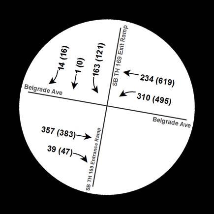
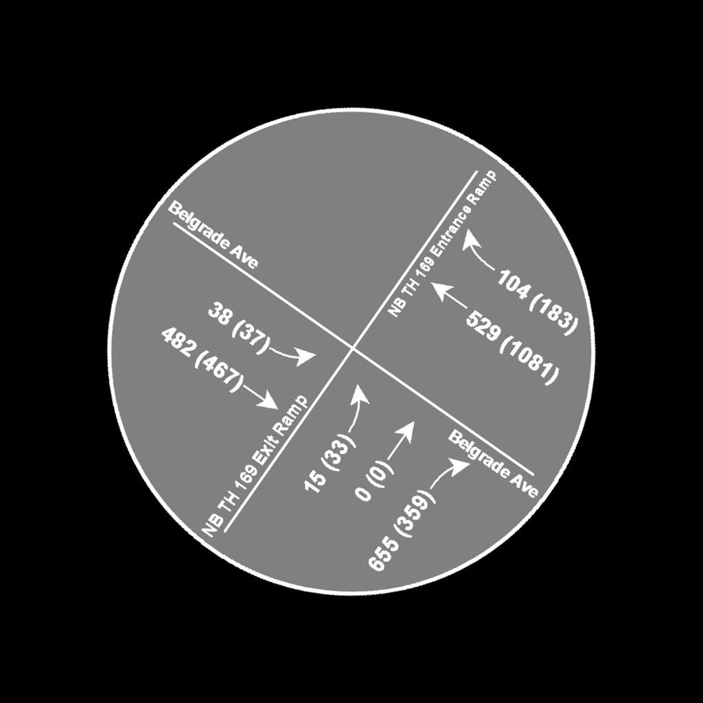
24 Appendix A: Turning Movement Counts Prepared by: Bolton & Menk, Inc. [Belgrade Avenue Corridor Study] ǀ [T ]


25
26 Appendix B: Intersection Crash Rates Prepared by: Bolton & Menk, Inc. [Belgrade Avenue Corridor Study] ǀ [T ]
27 Intersection Safety Screening Intersection: Belgrade Avenue at NB TH 169 Ramps Crash Data, Crashes by Crash Severity Intersection Characteristics Fatal Incapacitating Injury Non-incapacitating Injury Possible Injury Property Damage Total Crashes Entering Volume Traffic Control Environment Speed Limit 21,400 Signals Suburban 30 mph Annual crash cost = $78,120 Statewide Comparison Total Crash Rate Observed Critical Rate Critical Index Signals: high volume, low speed Fatal & Serious Injury Crash Rate 0.33 Observed Critical Rate Critical Index 0.00 The observed crash rate is the number of crashes per million entering vehicles (MEV). The critical rate is a statistical comparison based on similar intersections statewide. An observed crash rate greater than the critical rate indicates that the intersection operates outside the expected, normal range. The critical index reports the magnitude of this difference. The observed total crash rate for this period is 0.33 per MEV; this is 68% below the critical rate. Based on similar statewide intersections, an additional 28 crashes over the five years would indicate this intersection operaters outside the normal range. The observed fatal and serious injury crash rate for this period is 0.00 per 100 MEV; this is 100% below the critical rate. The intersection operates within the normal range. Developed by MnDOT Office of Traffic, Safety Technology. May 2014.
28 Intersection Safety Screening Intersection: Belgrade Avenue at SB TH 169 Ramps Crash Data, Crashes by Crash Severity Intersection Characteristics Fatal Incapacitating Injury Non-incapacitating Injury Possible Injury Property Damage Total Crashes Entering Volume Traffic Control Environment Speed Limit 15,600 Signals Suburban 30 mph Annual crash cost = $143,960 Statewide Comparison Total Crash Rate Observed Critical Rate Critical Index Signals: low volume, low speed Fatal & Serious Injury Crash Rate 0.49 Observed Critical Rate Critical Index 0.86 The observed crash rate is the number of crashes per million entering vehicles (MEV). The critical rate is a statistical comparison based on similar intersections statewide. An observed crash rate greater than the critical rate indicates that the intersection operates outside the expected, normal range. The critical index reports the magnitude of this difference. The observed total crash rate for this period is 0.49 per MEV; this is 47% below the critical rate. Based on similar statewide intersections, an additional 13 crashes over the five years would indicate this intersection operaters outside the normal range. The observed fatal and serious injury crash rate for this period is 3.51 per 100 MEV; this is 14% below the critical rate. The intersection operates within the normal range. Developed by MnDOT Office of Traffic, Safety Technology. May 2014.
29 Intersection Safety Screening Intersection: Belgrade Avenue at Range Street Crash Data, Crashes by Crash Severity Intersection Characteristics Fatal Incapacitating Injury Non-incapacitating Injury Possible Injury Property Damage Total Crashes Entering Volume Traffic Control Environment Speed Limit 10,300 All stop Suburban 30 mph Annual crash cost = $71,800 Statewide Comparison Total Crash Rate Observed Critical Rate Critical Index All Way Stop Fatal & Serious Injury Crash Rate 0.43 Observed Critical Rate Critical Index 0.00 The observed crash rate is the number of crashes per million entering vehicles (MEV). The critical rate is a statistical comparison based on similar intersections statewide. An observed crash rate greater than the critical rate indicates that the intersection operates outside the expected, normal range. The critical index reports the magnitude of this difference. The observed total crash rate for this period is 0.43 per MEV; this is 40% below the critical rate. Based on similar statewide intersections, an additional 6 crashes over the five years would indicate this intersection operaters outside the normal range. The observed fatal and serious injury crash rate for this period is 0.00 per 100 MEV; this is 100% below the critical rate. The intersection operates within the normal range. Developed by MnDOT Office of Traffic, Safety Technology. May 2014.
30 Intersection Safety Screening Intersection: Belgrade Avenue at Center Street Crash Data, Crashes by Crash Severity Intersection Characteristics Fatal Incapacitating Injury Non-incapacitating Injury Possible Injury Property Damage Total Crashes Entering Volume Traffic Control Environment Speed Limit 8,200 All stop Suburban 30 mph Annual crash cost = $20,640 Statewide Comparison Total Crash Rate Observed Critical Rate Critical Index All Way Stop Fatal & Serious Injury Crash Rate 0.27 Observed Critical Rate Critical Index 0.00 The observed crash rate is the number of crashes per million entering vehicles (MEV). The critical rate is a statistical comparison based on similar intersections statewide. An observed crash rate greater than the critical rate indicates that the intersection operates outside the expected, normal range. The critical index reports the magnitude of this difference. The observed total crash rate for this period is 0.27 per MEV; this is 65% below the critical rate. Based on similar statewide intersections, an additional 8 crashes over the five years would indicate this intersection operaters outside the normal range. The observed fatal and serious injury crash rate for this period is 0.00 per 100 MEV; this is 100% below the critical rate. The intersection operates within the normal range. Developed by MnDOT Office of Traffic, Safety Technology. May 2014.
31 Intersection Safety Screening Intersection: Belgrade Avenue at Sherman Street Crash Data, Crashes by Crash Severity Intersection Characteristics Fatal Incapacitating Injury Non-incapacitating Injury Possible Injury Property Damage Total Crashes Entering Volume Traffic Control Environment Speed Limit 7,000 Thru / stop Suburban 30 mph Annual crash cost = $132,120 Statewide Comparison Total Crash Rate Observed Critical Rate Critical Index Urban Thru / Stop Fatal & Serious Injury Crash Rate 0.47 Observed Critical Rate Critical Index 1.26 The observed crash rate is the number of crashes per million entering vehicles (MEV). The critical rate is a statistical comparison based on similar intersections statewide. An observed crash rate greater than the critical rate indicates that the intersection operates outside the expected, normal range. The critical index reports the magnitude of this difference. The observed total crash rate for this period is 0.47 per MEV; this is 12% below the critical rate. Based on similar statewide intersections, an additional 1 crashes over the five years would indicate this intersection operaters outside the normal range. The observed fatal and serious injury crash rate for this period is 7.82 per 100 MEV; this is 1.3 times the critical rate. Developed by MnDOT Office of Traffic, Safety Technology. May 2014.
32 Intersection Safety Screening Intersection: Belgrade Avenue at reet Crash Data, Crashes by Crash Severity Intersection Characteristics Fatal Incapacitating Injury Non-incapacitating Injury Possible Injury Property Damage Total Crashes Entering Volume Traffic Control Environment Speed Limit 6,250 Thru / stop Suburban 30 mph Annual crash cost = $49,680 Statewide Comparison Total Crash Rate Observed Critical Rate Critical Index Urban Thru / Stop Fatal & Serious Injury Crash Rate 0.26 Observed Critical Rate Critical Index 0.00 The observed crash rate is the number of crashes per million entering vehicles (MEV). The critical rate is a statistical comparison based on similar intersections statewide. An observed crash rate greater than the critical rate indicates that the intersection operates outside the expected, normal range. The critical index reports the magnitude of this difference. The observed total crash rate for this period is 0.26 per MEV; this is 53% below the critical rate. Based on similar statewide intersections, an additional 4 crashes over the five years would indicate this intersection operaters outside the normal range. The observed fatal and serious injury crash rate for this period is 0.00 per 100 MEV; this is 100% below the critical rate. The intersection operates within the normal range. Developed by MnDOT Office of Traffic, Safety Technology. May 2014.

33 Intersection Safety Screening Intersection: Belgrade Avenue at Lee Street Crash Data, Crashes by Crash Severity Intersection Characteristics Fatal Incapacitating Injury Non-incapacitating Injury Possible Injury Property Damage Total Crashes Entering Volume Traffic Control Environment Speed Limit 13,450 Thru / stop Suburban 30 mph Annual crash cost = $39,800 Statewide Comparison Total Crash Rate Observed Critical Rate Critical Index Urban Thru / Stop Fatal & Serious Injury Crash Rate 0.29 Observed Critical Rate Critical Index 0.00 The observed crash rate is the number of crashes per million entering vehicles (MEV). The critical rate is a statistical comparison based on similar intersections statewide. An observed crash rate greater than the critical rate indicates that the intersection operates outside the expected, normal range. The critical index reports the magnitude of this difference. The observed total crash rate for this period is 0.29 per MEV; this is 32% below the critical rate. Based on similar statewide intersections, an additional 4 crashes over the five years would indicate this intersection operaters outside the normal range. The observed fatal and serious injury crash rate for this period is 0.00 per 100 MEV; this is 100% below the critical rate. The intersection operates within the normal range. Developed by MnDOT Office of Traffic, Safety Technology. May 2014.
Chapter 6: Transportation
 Chapter 6: Transportation I. INTRODUCTION The purpose of the Transportation Plan element of the Comprehensive Plan is to provide guidance to the City of North Mankato, as well as existing and future landowners
Chapter 4 Traffic Analysis
 Chapter 4 Traffic Analysis PURPOSE The traffic analysis component of the K-68 Corridor Management Plan incorporates information on the existing transportation network, such as traffic volumes and intersection
City of Wayzata Comprehensive Plan 2030 Transportation Chapter: Appendix A
 A1. Functional Classification Table A-1 illustrates the Metropolitan Council s detailed criteria established for the functional classification of roadways within the Twin Cities Metropolitan Area. Table
Appendix G: Future Conditions Traffic Analysis Memorandum
 ppendix G: Future Conditions Traffic nalysis Memorandum Prepared by: Bolton & Menk, Inc. Riverfront Drive Corridor Study ǀ T42.867 ppendix MEMORNDUM Date: pril, 27 To: Paul Vogel From: Ross B. Tillman,
Route 7 Corridor Study
 Route 7 Corridor Study Executive Summary Study Area The following report analyzes a segment of the Virginia State Route 7 corridor. The corridor study area, spanning over 5 miles in length, is a multi
5 CIRCULATION AND STREET DESIGN
 5 CIRCULATION AND STREET DESIGN This chapter describes circulation and streetscape improvements proposed for the Northwest Chico Specific Plan Area. It includes detailed design specifications for existing
APPENDIX G: INTERSECTION NEEDS AT OKEECHOBEE BOULEVARD
 APPENDIX G: INTERSECTION NEEDS AT OKEECHOBEE BOULEVARD INTERSECTION NEEDS AT SR 7 and OKEECHOBEE BOULEVARD SR 7 Extension Project Development and Environment (PD&E) Study From Okeechobee Boulevard (SR
Highway 111 Corridor Study
 Highway 111 Corridor Study June, 2009 LINCOLN CO. HWY 111 CORRIDOR STUDY Draft Study Tea, South Dakota Prepared for City of Tea Sioux Falls Metropolitan Planning Organization Prepared by HDR Engineering,
5.0 Roadway System Plan
 Southwest Boise Transportation Study Page 16 5.0 Roadway System Plan The Roadway System Plan outlines roadway improvements in the Initial Study Area. It forecasts future deficiencies on the arterial system,
TRAFFIC IMPACT ANALYSIS
 TRAFFIC IMPACT ANALYSIS FOR THE CHAMPAIGN UNIT#4 SCHOOL DISTRICT PROPOSED HIGH SCHOOL (SPALDING PARK SITE) IN THE CITY OF CHAMPAIGN Final Report Champaign Urbana Urbanized Area Transportation Study 6/24/2014
CONNECTING PEOPLE TO PLACES
 CONNECTING PEOPLE TO PLACES 82 EAST BENCH MASTER PLAN 07 Introduction The East Bench transportation system is a collection of slow moving, treelined residential streets and major arteries that are the
M-58 HIGHWAY ACCESS MANAGEMENT STUDY Mullen Road to Bel-Ray Boulevard. Prepared for CITY OF BELTON. May 2016
 M-58 HIGHWAY ACCESS MANAGEMENT STUDY Prepared for CITY OF BELTON By May 2016 Introduction Missouri State Highway 58 (M-58 Highway) is a major commercial corridor in the City of Belton. As development has
Overview. Existing Conditions. Corridor Description. Assessment
 Overview A study of the 23 rd Street corridor was undertaken to document the existing conditions, analyze traffic operations, and recommend remedies for deficient situations Although 23 rd Street is frequently
Project Description Form 8EE
 Project Description Form 8EE Basic Project Information Submitting Jurisdiction/Agency: Town of Dumfries Project Title: Route 1 (Fraley Blvd) Widening: Brady's Hill Road to Dumfries Road Project Location:
Clackamas County Comprehensive Plan
 ROADWAYS The County s road system permits the movement of goods and people between communities and regions, using any of a variety of modes of travel. Roads provide access to virtually all property. They
City of Homewood Transportation Plan
 City of Homewood Transportation Plan Prepared for: City of Homewood, Alabama Prepared by: Skipper Consulting, Inc. May 2007 TABLE OF CONTENTS INTRODUCTION... 1 BACKGROUND INFORMATION... 1 EXISTING TRANSPORTATION
4. ENVIRONMENTAL IMPACT ANALYSIS 9. TRANSPORTATION AND TRAFFIC
 4. ENVIRONMENTAL IMPACT ANALYSIS 9. TRANSPORTATION AND TRAFFIC 4.9.1 INTRODUCTION The following section addresses the Proposed Project s impact on transportation and traffic based on the Traffic Study
Walmart (Store # ) 60 th Street North and Marion Road Sioux Falls, South Dakota
 60 th Street North and Marion Road Sioux Falls, South Dakota") Walmart (Store #4865-00) 60 th Street North and Marion Road Sioux Falls, South Dakota Prepared for: Wal-Mart Stores, Inc. Bentonville, Arkansas Prepared by: Kimley-Horn and Associates, Inc. ã2013 Kimley-Horn
Walmart (Store #4865-00) 60 th Street North and Marion Road Sioux Falls, South Dakota Prepared for: Wal-Mart Stores, Inc. Bentonville, Arkansas Prepared by: Kimley-Horn and Associates, Inc. ã2013 Kimley-Horn
JONESBORO HIGHWAY 63 HIGHWAY 18 CONNECTOR STUDY
 JONESBORO HIGHWAY 63 HIGHWAY 18 CONNECTOR STUDY Craighead County May 2007 JONESBORO HIGHWAY 63 HIGHWAY 18 CONNECTOR STUDY Craighead County May 2007 Prepared by Planning and Research Division Arkansas State
Dr. M.L. King, Jr. Street North Complete Streets Resurfacing Opportunities HOUSING, LAND USE, AND TRANSPORTATION COMMITTEE MARCH 22, 2018
 Dr. M.L. King, Jr. Street North Complete Streets Resurfacing Opportunities HOUSING, LAND USE, AND TRANSPORTATION COMMITTEE MARCH 22, 2018 What s Happening The City plans to mill and resurface Dr. M.L.
ADOT Statewide Bicycle and Pedestrian Program Summary of Phase IV Activities APPENDIX B PEDESTRIAN DEMAND INDEX
 ADOT Statewide Bicycle and Pedestrian Program Summary of Activities APPENDIX B PEDESTRIAN DEMAND INDEX May 24, 2009 Pedestrian Demand Index for State Highway Facilities Revised: May 29, 2007 Introduction
Access Management Regulations and Standards
 Access Management Regulations and Standards Efficient highway operation Reasonable property access Concept of Access Management The way to manage access to land development while simultaneously preserving
5858 N COLLEGE, LLC N College Avenue Traffic Impact Study
 5858 N COLLEGE, LLC nue Traffic Impact Study August 22, 2016 Contents Traffic Impact Study Page Preparer Qualifications... 1 Introduction... 2 Existing Roadway Conditions... 5 Existing Traffic Conditions...
Executive Summary Route 30 Corridor Master Plan
 Route Corridor Master Plan Project Overview The Route Corridor Master Plan is a coordinated multimodal transportation and land use plan for the entire stretch of Route through East Whiteland Township,
Bridge Street Corridor Study Report
 Bridge Street Corridor Study Report Prepared for: Prepared by: BRIDGE STREET CORRIDOR STUDY REPORT PREPARED FOR: CITY OF ARROYO GRANDE COMMUNITY DEVELOPMENT DEPARTMENT 300 EAST BRANCH STREET ARROYO GRANDE,
Planning Study SR 976. Project Advisory Team Meeting May 24, 2017
 ` SR 976 BIRD ROAD/SW 40TH STREET FROM SR 821/HEFT TO SR 5/US-1 Miami-Dade County, Florida FPID No.: 434845-4-22-01 Planning Study Project Advisory Team Meeting May 24, 2017 1 Agenda Introductions Project
City of Gainesville Transportation/Roadway Needs PROJECT SUMMARY
 A1 Roadway Resurfacing $23,846,000 TYPE: Preservation of existing system Roadway resurfacing A2 Signal Replacement $6,000,000 TYPE: Preservation of existing system Replace traffic signals. B1 W 6th St
West Dimond Blvd Upgrade Jodhpur Street to Sand Lake Road
 West Dimond Blvd Jodhpur St to Sand Lake CSS Transportation Project Summary Municipality of Anchorage Project # 05 005 Project Manager: John Smith, P.E. (MOA PM&E) Project Administrator: Julie Makela,
TRASBURG RANSPORTATION
 TRASBURG RANSPORTATION LAN DEVELOPED BY THE TRANSPORTATION PLANNING DIVISION OF THE VIRGINIA DEPARTMENT OF TRANSPORTATION IN COOPERATION WITH THE U.S. DEPARTMENT OF TRANSPORTATION, FEDERAL HIGHWAY ADMINISTRATION
Highway 49, Highway 351 and Highway 91 Improvements Feasibility Study Craighead County
 Highway 49, Highway 351 and Highway 91 Improvements Feasibility Study Craighead County Executive Summary March 2015 Highway 49, Highway 351 and Highway 91 Improvements Feasibility Study Craighead County
Route 79/Davol Street Corridor Study
 Route 79/Davol Street Corridor Study Fall River, MA Public Information Meeting #2 November 21, 2013 Fall River Heritage State Park Fall River, MA Agenda Welcome and Introductions Overview of Study Process
Chapter 5 Future Transportation
 Chapter 5 Future Transportation The Future Land Use Plan identifies the desired land use designations. The land uses desired for Crozet depend, in large part, on the success of the transportation system,
Transportation Corridor Studies: Summary of Recommendations
 Transportation Corridor Studies: Summary of Recommendations Route 4 Corridor Study: Route 10 Corridor Study: Route 44 Corridor Study: Route 175 Corridor Study: Route 5/15 Corridor Study: Rentschler Field
FINAL DESIGN TRAFFIC TECHNICAL MEMORANDUM
 FINAL DESIGN TRAFFIC TECHNICAL MEMORANDUM July 2014 FINAL (SR 43) Project Development and Environment Study From State Road 60 (Adamo Drive) to I-4 (SR 400) Hillsborough County, Florida Work Program Item
Report. Typical Sections. City of Middleton, WI
 Report Typical Sections City of Middleton, WI December 2006 Report for City of Middleton, Wisconsin Typical Sections repared by: Traffic Associates LLC and STRAND ASSOCIATES, INC. 910 West Wingra Drive
CITY OF COCOA BEACH 2025 COMPREHENSIVE PLAN. Section VIII Mobility Element Goals, Objectives, and Policies
 CITY OF COCOA BEACH 2025 COMPREHENSIVE PLAN Section VIII Mobility Element Goals, Objectives, and Policies Adopted August 6, 2015 by Ordinance No. 1591 VIII MOBILITY ELEMENT Table of Contents Page Number
Southview Blvd & 3 rd Avenue Improvement Project. Public Open House December 4, to 7pm
 Southview Blvd & 3 rd Avenue Improvement Project Public Open House December 4, 2014 5 to 7pm Southview Blvd & 3 rd Avenue Public Information Meeting Agenda Presentation 5:30 to 6:15 pm Purpose of Project
Bus Rapid Transit Plans
 Twin Cities Region Bus Rapid Transit Plans ULI Minnesota Workshop Connecting Bus Rapid Transit to the Community December 15, 2009 John Levin Director of Service Development Metro Transit Metropolitan Area
HENDERSON DEVELOPMENT 213, 217, 221, 221 ½, 223 HENDERSON AVENUE and 65 TEMPLETON STREET OTTAWA, ONTARIO TRANSPORTATION OVERVIEW.
 HENDERSON DEVELOPMENT 213, 217, 221, 221 ½, 223 HENDERSON AVENUE and 65 TEMPLETON STREET OTTAWA, ONTARIO TRANSPORTATION OVERVIEW Prepared for: 2294170 Ontario Inc. February 2, 2017 117-652 Report_1.doc
APPENDIX H EXISTING TRAFFIC CONDITIONS ANALYSIS
 APPENDIX H EXISTING TRAFFIC CONDITIONS ANALYSIS MEMO : Peter Steacy, P.Eng. Date: December 3, 2014 : Ian Borsuk, P.Eng. Job No.: 3414015-000 Subject: City of Ottawa O-Train Extension Planning & EA Study
APPENDIX D. May 22, 2002 Open House Summary and Materials
 APPENDIX D May 22, 2002 Open House Summary and Materials TH 36 Partnership Study Open House May 22, 2002 Summary of Survey Responses 1. If no new crossing of the St. Croix River is built (e.g. the existing
Basalt Creek Transportation Refinement Plan Recommendations
 Basalt Creek Transportation Refinement Plan Recommendations Introduction The Basalt Creek transportation planning effort analyzed future transportation conditions and evaluated alternative strategies for
1609 E. FRANKLIN STREET HOTEL TRAFFIC IMPACT STUDY EXECUTIVE SUMMARY
 1609 E. FRANKLIN STREET HOTEL TRAFFIC IMPACT STUDY EXECUTIVE SUMMARY Prepared for: The Town of Chapel Hill Public Works Department Traffic Engineering Division Prepared by: HNTB North Carolina, PC 343
PRELIMINARY DRAFT WADDLE ROAD / I-99 INTERCHANGE PROJECT ALTERNATIVE ANALYSIS FINAL TRAFFIC SUMMARY REPORT
 PRELIMINARY DRAFT WADDLE ROAD / I-99 INTERCHANGE PROJECT ALTERNATIVE ANALYSIS FINAL TRAFFIC SUMMARY REPORT Prepared by: In Association with: November 2013 EXECUTIVE SUMMARY Patton Township, in partnership
SNCC Demographic Trends
 Employment Population SNCC Demographic Trends In 1970 the SNCC population was 10,040, accounting for roughly 3% of the County population In 2015, SNCC grew to 60,567 people, roughly 11% of the County population
DRAFT Davidson Elementary School Expansion Transportation Impact Analysis
 DRAFT Davidson Elementary School Expansion Transportation Impact Analysis Prepared for: Town of Davidson 216 S. Main Street Davidson, NC 28036 Prepared by: Stantec Consulting Services Inc. 2127 Ayrsley
Performance Criteria for 2035 Long Range Transportation Plan
 Minimizing Impacts on Natural, Historic, Cultural or Archeological Resources 2035 LRTP Weighting Factor: 7% Objective 1.1: Use appropriate planning and design criteria to protect and enhance the built
TRAFFIC ACTION PLAN. Laurie Meadows Neighborhood CITY OF SAN MATEO
 TRAFFIC ACTION PLAN Laurie Meadows Neighborhood CITY OF SAN MATEO Draft January 2017 Table of Contents Introduction... 2 The Traffic Forum Process... 5 Neighborhood Traffic Issues... 7 Neighborhood Recommendations
MCTC 2018 RTP SCS and Madera County RIFP Multi-Modal Project Eval Criteria GV13.xlsx
 MCTC 8 RTP SCS and Madera County RIFP Multi-Modal Project Eval Criteria GV.xlsx Madera County Transportation Commission Regional Transportation Plan / Sustainable Communities Strategy Multi-Modal Project
Waterford Lakes Small Area Study
 Waterford Lakes Small Area Study Existing Traffic Conditions PREPARED FOR: ORANGE COUNTY PUBLIC WORKS DEPARTMENT TRAFFIC ENGINEERING DIVISION ORLANDO, FLORIDA PREPARED WITH: INWOOD CONSULTING ENGINEERS
Date: April 7, 2015 To: Chris Hartzell, PE Dakota County, MN From: Jacob Bongard, PE Bolton & Menk, Inc. Subject: Traffic Considerations Memorandum
 M E M O R A N D U M Date: April 7, 2015 To: Chris Hartzell, PE Dakota County, MN From: Jacob Bongard, PE Bolton & Menk, Inc. Subject: Traffic Considerations Memorandum I. Introduction The objective of
Roundabout Feasibility Memorandum
 Roundabout Feasibility Memorandum To From Gwen Pipkin Bill Howell Date June 18, 2013 Subject Roundabout Feasibility Study SR 29 PD&E Study From Oil Well Road to SR 82 Collier County, FL FPID 417540-1-22-01
SECTION 1 - TRAFFIC PLANNING
 SECTION 1 - TRAFFIC PLANNING 1.1 TRAFFIC OPERATIONS 1.1.1 Roadway Functional Classification The Multnomah County Comprehensive Framework Plan s Policy 34: Trafficways and the Functional Classification
ACTIVE TRANSPORTATION
 ACTIVE TRANSPORTATION Mobility 2040 Supported Goals Improve the availability of transportation options for people and goods. Support travel efficiency measures and system enhancements targeted at congestion
TRANSPORTATION & MOBILITY
 TRANSPORTATION & MOBILITY ROADWAY SYSTEM There are approximately 40 miles of roadways in Manitou Springs. For planning purposes, roadways are typically assigned a functional classification which defines
Subject: Solberg Avenue / I-229 Grade Separation: Traffic Analysis
 MEMORANDUM Transportation Bill Troe, AICP Jason Carbee, AICP 12120 Shamrock Plaza Suite 300 Omaha, NE 68154 (402) 334-8181 (402) 334-1984 (Fax) To: Project File Date: Subject: Solberg Avenue / I-229 Grade
Chapter 3: Multi-Modal Circulation and Streetscapes
 CHAPTER 3: MULTI-MODAL CIRCULATION AND STREETSCAPES Chapter 3: Multi-Modal Circulation and Streetscapes Overview Streetscape improvements have already been completed for Depot Street between Main Avenue
Complete Street Analysis of a Road Diet: Orange Grove Boulevard, Pasadena, CA
 Complete Street Analysis of a Road Diet: Orange Grove Boulevard, Pasadena, CA Aaron Elias, Bill Cisco Abstract As part of evaluating the feasibility of a road diet on Orange Grove Boulevard in Pasadena,
Town of Bethlehem. Planning Assessment. Bethlehem Town Board
 Town of Bethlehem US 9W Corridor Transportation Planning Assessment Presented e to: Bethlehem Town Board June 2009 Overview Study Background Route 9W Corridor Conditions and Improvements Selkirk Bypass
DRAFT BUENA VISTA 2020 TRANSPORTATION PLAN
 DRAFT BUENA VISTA 2020 TRANSPORTATION PLAN DEVELOPED BY THE TRANSPORTATION PLANNING DIVISION OF THE VIRGINIA DEPARTMENT OF TRANSPORTATION IN COOPERATION WITH THE U.S. DEPARTMENT OF TRANSPORTATION, FEDERAL
Lynchburg District Update
 Lynchburg District Update Virginia Statewide Bicycle and Pedestrian Advisory Committee Spring Meeting May 16 th, 2017 David Cook Transportation Planner, VDOT Lynchburg District Table of Contents Active
I-105 Corridor Sustainability Study (CSS)
") I-105 Corridor Sustainability Study (CSS) Metro Streets and Freeways Subcommittee March 21, 2019 Gary Hamrick Cambridge Systematics, Inc. I-105 CSS Project History & Background Funded by Caltrans Sustainable
I-105 Corridor Sustainability Study (CSS) Metro Streets and Freeways Subcommittee March 21, 2019 Gary Hamrick Cambridge Systematics, Inc. I-105 CSS Project History & Background Funded by Caltrans Sustainable
Traffic Impact Memorandum. May 22, 2018
 BISHOP PROFESSIONAL DEVELOPMENT BUILDING Proposed Land-use Change & Parking Modification 3601 SW 31st Street Topeka, Kansas 66614 CFS Project No. 185077 Traffic Impact Memorandum May 22, 2018 Prepared
University Hill Transportation Study Technical Memorandum Alternatives Modeling and Analysis May 2007
 Technical Memorandum May 2007 Syracuse Metropolitan Transportation Council Edwards and Kelcey with Wallace Roberts and Todd Alta Planning and Design CONTENTS SECTION ONE- INTRODUCTION...1 SECTION TWO-
THIS PAGE LEFT BLANK INTENTIONALLY
 GA SR 25 Spur at Canal Road Transportation Impact Analysis PREPARED FOR GLYNN COUNTY, GEORGIA 1725 Reynolds Street, Suite 300 Brunswick, Georgia 31520 PREPARED BY 217 Arrowhead Boulevard Suite 26 Jonesboro,
Bay to Bay Boulevard Complete Streets Project
 Bay to Bay Boulevard Complete Streets Project Dale Mabry Highway to Bayshore Boulevard February 08, 2018 Photo Source: Tampa Bay Times Alessandra Da Pra Meeting Format Introduction Resurfacing Information
NM-POLICY 1: Improve service levels, participation, and options for non-motorized transportation modes throughout the County.
 Transportation PRINCE WILLIAM COUNTY 2008 COMPREHENSIVE PLAN NON-MOTORIZED PLAN CONTENTS Goals, Policies, and Action Strategies Table 4 (Bike Facility Classifications and Descriptions) Table 5 (Bike Facility
EXECUTIVE SUMMARY OF CALEDON TRANSPORTATION NEEDS STUDY
 EXECUTIVE SUMMARY OF CALEDON TRANSPORTATION NEEDS STUDY The Caledon Transportation Needs Study has been undertaken as a joint project by the Town of Caledon and the Region of Peel to determine the existing
Intersection Traffic Control Feasibility Study
 Intersection Traffic Control Feasibility Study CSAH 9 at CSAH 60 (185th Avenue) Prepared For: Dakota County Transportation Department Western Service Center 14955 Galaxie Avenue, 3rd Floor Apple Valley,
Executive Summary June 2015
 Executive Summary June 2015 Highway 112 Corridor Study Benton and Washington Counties Executive Summary June 2015 Prepared by Transportation Planning and Policy Division Arkansas State Highway and Transportation
Community Advisory Committee
 Community Advisory Committee Meeting #1 November 19, 2014 Presentation Team Matt Fulda, Greater Bridgeport Regional Council Chris Granatini, P.E., Tighe & Bond Craig Yannes, P.E., PE PTOE, Tighe & Bond
Bikeway action plan. Bicycle Friendly Community Workshop March 5, 2007 Rochester, MN
 Bikeway action plan Summary The was held on March 5, 2007 at the Rochester Mayo Civic Center. The workshop was hosted by Rochester-Olmsted County Planning Department in collaboration with the League of
ALLEY 24 TRAFFIC STUDY
 ALLEY 24 TRAFFIC STUDY in City of Frostburg, Maryland January 2013 3566 Teays Valley Road Hurricane, WV Office: (304) 397-5508 www.denniscorporation.com Alley 24 Traffic Study January 2013 Frostburg, Maryland
Project Development & Environment (PD&E) Study. November 17, SR 90 (SW 8th Street and SW 7th Street) SW 8 th Street/SW 7 th Street PD&E Study 1
 Study. November 17, SR 90 (SW 8th Street and SW 7th Street) SW 8 th Street/SW 7 th Street PD&E Study 1") Financial Management Number: 432639-6-22-01 Federal Aid Project Number: 0202-054-P Efficient Transportation Decision Making Number: 14230 Project Development & Environment (PD&E) Study SR 90 (SW 8th Street
Financial Management Number: 432639-6-22-01 Federal Aid Project Number: 0202-054-P Efficient Transportation Decision Making Number: 14230 Project Development & Environment (PD&E) Study SR 90 (SW 8th Street
Appendix C. NORTH METRO STATION AREA TRAFFIC IMPACT STATEMENT 88th Avenue Station
 Appendix C NORTH METRO STATION AREA TRAFFIC IMPACT STATEMENT 88th Avenue Station Prepared for: Regional Transportation Department and URS Corporation as part of the North Metro EIS David Evans and Associates,
METHODOLOGY. Signalized Intersection Average Control Delay (sec/veh)
") Chapter 5 Traffic Analysis 5.1 SUMMARY US /West 6 th Street assumes a unique role in the Lawrence Douglas County transportation system. This principal arterial street currently conveys commuter traffic
Chapter 5 Traffic Analysis 5.1 SUMMARY US /West 6 th Street assumes a unique role in the Lawrence Douglas County transportation system. This principal arterial street currently conveys commuter traffic
Non-Motorized Transportation 7-1
 Non-Motorized Transportation 7-1 Transportation facilities no longer mean just accommodating a vehicle powered by a combustion engine. Pedestrian and non-motorized facilities are important modes of travel
Regional Transportation Needs Within Southeastern Wisconsin
 Regional Transportation Needs Within Southeastern Wisconsin #118274 May 24, 2006 1 Introduction The Southeastern Wisconsin Regional Planning Commission (SEWRPC) is the official areawide planning agency
Angie Silva Kitsap County Commissioners Office Stef Herzstein, PE, PTOE Transpo Group Jessica Lambert Transpo Group
 DRAFT MEMORANDUM Date: September 30, 2016 TG: 16125.00 To: From: cc: Subject: Angie Silva Kitsap County Commissioners Office Stef Herzstein, PE, PTOE Transpo Group Jessica Lambert Transpo Group Erik Rundell
Goodlettsville Bicycle and Pedestrian Plan Executive Summary
 Goodlettsville Bicycle and Pedestrian Plan July 2010 In Cooperation with the Nashville Area Metropolitan Planning Executive Organization Summary Introduction Progressive and forward thinking communities
o n - m o t o r i z e d transportation is an overlooked element that can greatly enhance the overall quality of life for the community s residents.
 N o n - m o t o r i z e d transportation is an overlooked element that can greatly enhance the overall quality of life for the community s residents. 84 Transportation CHAPTER 11 INTRODUCTION Transportation
180 Grand Avenue, Suite x117 Dowling Associates, Inc.
 180 Grand Avenue, Suite 250 510.839.1742 x117 Oakland, CA 94612 510.839.0871 fax www.dowlinginc.com mbowman@dowlinginc.com Dowling Associates, Inc. Date: Memorandum To: CC: From: Ms. Leah Greenblat City
TRANSPORTATION ANALYSIS REPORT US Route 6 Huron, Erie County, Ohio
 TRANSPORTATION ANALYSIS REPORT US Route 6 Huron, Erie County, Ohio December 12, 2012 Prepared for: The City of Huron 417 Main Huron, OH 44839 Providing Practical Experience Technical Excellence and Client
CHAPTER 7 ACCESS MANAGEMENT. Background. Principles of Access Management. Hennepin County Transportation Systems Plan (HC-TSP)
") CHAPTER 7 ACCESS MANAGEMENT Background Principles of Access Management Hennepin County Transportation Systems Plan (HC-TSP) Chapter 7 Access Management 7.1 Background Access management has become an important
CHAPTER 7 ACCESS MANAGEMENT Background Principles of Access Management Hennepin County Transportation Systems Plan (HC-TSP) Chapter 7 Access Management 7.1 Background Access management has become an important
Date: April 4, Project #: Re: A Street/Binford Street Traffic/Intersection Assessment
 To: Peter Cavanaugh General Electric From: David Bohn, PE Ryan White, PE Date: April 4, 217 Project #: 13421. Re: / Traffic/Intersection Assessment Consistent with the Cooperation Agreement between the
Magnolia Place. Traffic Impact Analysis. Prepared for: City of San Mateo. Prepared by: Hexagon Transportation Consultants, Inc.
 Magnolia Place Traffic Impact Analysis Prepared for: City of San Mateo Prepared by: Hexagon Transportation Consultants, Inc. Updated January 4, 2010 Table of Contents 1. Introduction...1 2. Existing Conditions...6
Vision: Traditional hamlet with an attractive business/pedestrian friendly main street connected to adjacent walkable neighborhoods
 N D. Focus Area II Vision: Traditional hamlet with an attractive business/pedestrian friendly main street connected to adjacent walkable neighborhoods Transit Road Focus Area II is located in the Hamlet
5.3 TRAFFIC, CIRCULATION AND PARKING
 5.3 TRAFFIC, CIRCULATION AND PARKING This section is based upon the Downtown Lancaster Specific Plan Traffic Impact Analysis (April 2, 2008) and the Downtown Lancaster Specific Plan Parking Analysis (May
APPENDIX A: Complete Streets Checklist DRAFT NOVEMBER 2016
 APPENDIX A: Complete Streets Checklist DRAFT NOVEMBER 2016 Complete Streets Checklist MetroPlan Orlando s Complete Streets Checklist is an internal planning tool for staff to further implementation of
Bicycle and Pedestrian Advisory Committee (BPAC) November 21, 2013
 November 21, 2013") Bicycle and Pedestrian Advisory Committee (BPAC) November 21, 2013 OVERALL LAND USE CONCEPT Overall Broadway Valdez District: 95.5 acres (35.1 acres right-of ways + 60.4 acres developable land) Plan Subareas:
Bicycle and Pedestrian Advisory Committee (BPAC) November 21, 2013 OVERALL LAND USE CONCEPT Overall Broadway Valdez District: 95.5 acres (35.1 acres right-of ways + 60.4 acres developable land) Plan Subareas:
Solana Beach Comprehensive Active Transportation Strategy (CATS)
") Solana Beach Comprehensive Active Transportation Strategy (CATS) 3.0 Goals & Policies The Solana Beach CATS goals and objectives outlined below were largely drawn from the Solana Beach Circulation Element
Solana Beach Comprehensive Active Transportation Strategy (CATS) 3.0 Goals & Policies The Solana Beach CATS goals and objectives outlined below were largely drawn from the Solana Beach Circulation Element
Route 29 Solutions Projects
 Route 29 Solutions Route 29 Solutions Projects www.route29solutions.org October 10, 2014 Route 29 Widening to Six Lanes Albemarle County This project will widen a 1.8-mile segment of Route 29 from four
CITY OF WEST LAKE HILLS. Forest View Neighborhood Traffic Calming Study
 CITY OF WEST LAKE HILLS 901 South Mopac Expressway Building V, Suite 220 Austin, Texas 78746 Texas P.E. Firm Registration No. F-929 Klotz Associates Final Report Submittal: March 20, 2015 Revised Final
Environmental Assessment Findings & Recommendations. Public Hearing November 13, 2014
 Environmental Assessment Findings & Recommendations Public Hearing November 13, 2014 Welcome! Welcome and Introductions Project and Environmental Assessment Overview Public Comments Adjourn Purpose of
Traffic Impact Analysis Walton Acres at Riverwood Athletic Club Clayton, NC
 Traffic Impact Analysis Walton Acres at Riverwood Athletic Club Clayton, NC 1. TABLE OF CONTENTS INTRODUCTION...1 1.1. Site Location and Study Area...1 1.2. Proposed Land Use and Site Access...2 1.3.
Orange Center Elementary School
 Drag and drop pic and stretch/crop to the limits of the blue rectangle (delete this text box) Orange Center Elementary School Drag and drop pic and stretch/crop to the limits of the blue rectangle (delete
CITY OF BLOOMINGTON COMPLETE STREETS POLICY
 CITY OF BLOOMINGTON COMPLETE STREETS POLICY POLICY OBJECTIVE: The City of Bloomington will enhance safety, mobility, accessibility and convenience for transportation network users of all ages and abilities,
Central Avenue Corridor Study FPID Number:
 Central Avenue Corridor Study FPID Number: 437932-1-18-01 City Commission Presentation 1 March 27, 2018 Meeting Agenda 1. Introductions 2. Project Overview 3. Opportunity for Economic Development 4. Healthy
CITY OF ALPHARETTA DOWNTOWN MASTER PLAN TRAFFIC EVALUATION
 CITY OF ALPHARETTA DOWNTOWN MASTER PLAN TRAFFIC EVALUATION June 2015 CITY OF ALPHARETTA DOWNTOWN MASTER PLAN TRAFFIC EVALUATION Introduction The Alpharetta Downtown Master Plan was developed in the fall
General Plan Circulation Element Update Scoping Meeting April 16, 2014 Santa Ana Senior Center, 424 W. 3rd Street, Santa Ana, CA 92701
 General Plan Circulation Element Update Scoping Meeting April 16, 2014 Santa Ana Senior Center, 424 W. 3rd Street, Santa Ana, CA 92701 Meeting Agenda 1. Purpose of Scoping Meeting 2. Project Overview 3.