Lisa Austin and Jasna Hadzic MnDOT; Greg Lindsey - UMN
|
|
|
- Sydney Patterson
- 6 years ago
- Views:
Transcription

1 Lisa Austin and Jasna Hadzic MnDOT; Greg Lindsey - UMN
2 Video Minnesota: Where Every Step Counts

3 National Bike and Ped Documentation Project Manual Counts with volunteers MnDOT Research Project NCHRP 7-19 study: Methods and Technologies for Collecting Pedestrian and Bicycle Volume Data FHWA Traffic Monitoring Guide

4 2050 Vision Minnesota Go: Achieve a multimodal transportation system that benefits the health of people, the environment, and our economy. Complete Streets: Understand vehicle, bicycle, and pedestrian interactions Achieve transportation goals listed in statue Toward Zero Deaths: Assess exposure and effectiveness of safety programs Performance measures: Increase bicycling, walking, and transit
5 Research and implementation projects Develop consistent methods for monitoring nonmotorized traffic in Minnesota Encourage communities to monitor bikes & pedestrians Provide training, and technical support for local monitoring programs Guidance for manual field counts Support for automated counting programs Create central repository for count data
6 Guiding principles Integrate with motor vehicle count program Build on experience (FHWA, TMG; NBPDP) FHWA Traffic Monitoring Guide Produce practical products for practitioners Provide for institutional sustainability
7 MnDOT Lisa Austin TL - Bike/Ped Jasna Hadzic TL Bike/Ped Gene Hicks - TDA Jim Miles D-1 - Traffic Forecasting Bobbie Retzlaff MnDOT Planning Melissa Barnes Traffic Engineer Bruce Holdhusen MnDOT Research Gina Mitteco MnDOT Metro Greta Alquist MnDOT Bike Plan Carson Gorecki Equipment Mark Flinner TRADAS Tim Mitchell Bike/Ped Section Supervisor CONSULTANT Erik Minge - SRF PRINCIPAL INVESTIGATOR Greg Lindsey U of M PARTNERS Simon Blenski City of Minneapolis James Gittimeier Duluth Superior MIC Tim Kelly - DNR Muhammad Khan Olmsted County Amber Dallman MDH Heidi Schallberg - MetCouncil Thomas Mercier Three Rivers Park District Reuben Collins City of Saint Paul Hennepin County TLC


8 Monitor trends in bicycle and pedestrian traffic Determine crash rates and assess safety Measure effects of road designs and traffic controls Project use of new facilities Measure effects of campaigns and promotions Assess economic impacts Inform investment decisions

 Safety")
9 Pedestrian Plan Spring 2014 Winter 2015 Bicycle Plan Spring 2013 Winter 2014/15 Data collection methodology Measuring progress Usage (frequency) Safety (crash rates) Prioritizing investments Measuring progress Usage (AADT, BMT ) Safety (crash rates)

10
11 EQUIPMENT TECHNOLOGY VENDOR AND MODEL Bicycle Counter - Portable Pneumatic Tubes Metro Count MC 5600 Bicycle Counter Permanent (on shoulder or bike lane) Inductive Loops Eco Counter ZELT Inductive loops Bicycle Counter Permanent (on trail) Inductive Loops Eco Counter ZELT Inductive loops Pedestrian Counter Portable Microwave Chambers Electronics RBBP7 Bicycle AND Pedestrian Counter Permanent passive Infrared and Inductive Loops Eco Counter MULTI


12 Eco Counter ZELT Inductive Loop Bicycles: Shoulder or Bike Lane Metro Count MC 5600 Pneumatic Tubes - Bicycles Chambers Electronics Microwave Pedestrians

13 Eco-Counter Equipment: Eco Counter ZELT Inductive Loops (Lane or Shoulder): Duluth Scenic 61 Minneapolis Central Ave Eagan TH 13 Eco Counter ZELT with saw cut loops: Installation on Midtown Greenway for NCHRP Passive Infrared and Inductive Loop Eco Multi with tape loops: Rochester Eco Multi with saw cut loops: Duluth Lake Walk Browns Creek - DNR


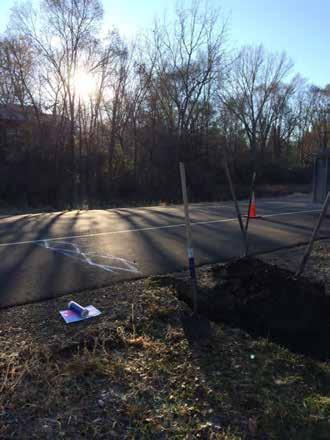
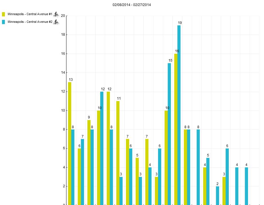
14 Eco Counter ZELT Inductive Loops: Minneapolis Central Avenue NE Eco Counter ZELT Inductive Loops: Eagan TH 13 near Lone Oak Road


15 Eco Counter ZELT Inductive Loops: Minneapolis Central Avenue NE SB & NB Eco Counter ZELT Inductive Loops: Brick removal/heavy duty hand holes required

16 Eco Counter ZELT Inductive Loops: Eco Counter ZELT Inductive Loops: Eagan TH13 near Lone Oak Road SB & NB


17 Eco Multi with saw cut loops & microwave chambers for pedestrian count validation Eco Multi & microwave chambers: Duluth Lake Walk


18 Eco Counter ZELT Inductive Loops: Duluth Scenic 61 North of Duluth to better capture commuter traffic


19 Location: Count Station 018 Bike/Ped Bridge Over Highway 14 West Semi Permanent Equipment Location: Count Station 019 Bike/Ped Bridge Over Silver Lake Portable Equipment

20 Location: CSAH 066/Broadway St NE & TH 65/Central Ave for Hennepin County Pneumatic Tubes: Currently being tested in in Hennepin County Metro Will be ready for statewide use early next summer: Gateway Trail DNR I-35 Bong Bridge MnDOT Ped. Bridge Over I-35 Duluth Bemidji Rosemount Microwave: currently being tested Rochester Metro Trail segment along I-94 Hennepin County Bong Bridge and Ped. Bridge Duluth And many more
21 HERE I WILL ADD DATA FROM HENNEPIN COUNTY, TEST DATA FROM METROCOUNT, AND RESULTS FROM CENTRAL AVE AND EAGAN.
22 MnDOT I-94 Trail (near Manning Road) (9/30/13 10/7/13) Traffic Mode Weekday Mean Weekend Mean Daily Mean Bicycle Pedestrian Total traffic
23 Identified 16 locations to test Minneapolis, 1 st & 2 nd ring suburbs, rural Streets with/without bike lanes, range of AADTs Multiuse trails Deployed equipment at most locations Preliminary results for both Chambers and Metrocount devices Have video for validation and calibration of counters at six sites (not yet done)
24 Location Bike Facility Type County Location Counter (v=video) CSAH 35 (Portland Ave S), S of 55th St E On-road bikeway (bike lane) Minneapolis MetroCount (v) CSAH 66 (Broadway St NE), E of TH65 (Central Ave NE) No bikeway, ADT >10,000 Minneapolis MetroCount (v) CSAH 53 (66th St W), W of CSAH 52 (Nicollet Ave), Richfield No bikeway, ADT >10,000 1st Ring Suburban MetroCount CSAH 27 (Stinson Blvd NE), N of CSAH 52 (Hennepin Ave NE) Off-road Trail Minneapolis MetroCount (v) Chambers (v) Chambers CSAH 3 (Excelsior Blvd), W of CSAH 61 (Shady Oak Rd), Minnetonka On-road bikeway (shoulder) 2nd Ring Suburban MetroCount Shingle Creek Parkway, W of CSAH 10 (Bass Lake Rd), Brooklyn Center Off-road Trail 1st Ring Suburban MetroCount Chambers CSAH 35 (Portland Ave S), S of 3rd St S CSAH 33 (Park Ave S), S of 3rd St S CSAH 5 (Minnetonka Blvd.), W of Honeywood Ln, Hopkins On-road bikeway (bike lane) On-road bikeway (bike lane) Off-road Trail Minneapolis Minneapolis 2nd Ring Suburban MetroCount (v) MetroCount (v) MetroCount Chambers CSAH 19, S of Larsen Rd., Corcoran Off-road Trail Rural MetroCount
25 Tested on 3 multi-use trails, obtained useful data Daily volumes varied by an order of magnitude across sites Mode-mix varied by location Hourly volumes reflect both utilitarian and recreational traffic patterns (potential factor groups) Still need to validate and calibrate counters
26 500 Figure 1. Measured, non-validated mean daily volumes, Chambers Mean Daily Volume Weekday Peds Weekday Bikes Weekend Peds Weekend Bikes Stinson Shingle Creek Minnetonka Location
27 60 Figure 2. Measured, non-validated mean daily volumes, Chambers (detail Shingle Creek and Minnetonka). 50 Mean Daily Volume Weekday Peds Weekday Bikes Weekend Peds Weekend Bikes 10 0 Shingle Creek Location Minnetonka
28 30 Figure 3. Weekday bicycle hourly distribution, Chambers. 25 Percent Contribution :00 2:00 4:00 6:00 8:00 10:00 12:00 14:00 16:00 18:00 20:00 22:00 Start of Measured Hour Stinson Bikes Shingle Creek Bikes Minnetonka Bikes
29 30 Figure 5. Weekday pedestrian hourly distribution, Chambers. 25 Percent Contribution :00 2:00 4:00 6:00 8:00 10:00 12:00 14:00 16:00 18:00 20:00 22:00 Start of Measured Hour Stinson Peds Shingle Creek Peds Minnetonka Peds
30 Installation Limited to off-road trails Maximum spacing of 10ft More involved than Metrocount installation May require driving steel posts into the ground Difficult to vertically align Long-term durability of plastic housings not yet demonstrated Distinguishes between pedestrians and cyclists Data stored in bins of adjustable duration Clean, modern data-logging software with simple data export
31 Metrocount devices Provide time stamps, speed, wheel base, etc. Classify vehicles in different schemes (e.g., FHWA) Do not generate bicycle classifications Require modification to yield bike counts Experimenting with 2 approaches Modified ARX (UMN: separate bikes from motorcycles based on wheel base and speed) BOCO (Boulder County, CO: reclassification of all ARX categories to extract bicycles)
32 Need to adjust axle base to differentiate bikes and motorcycles Need to reclassify trucks to separate misclassified bicycles Source: Hyde-wright, Graham, and Nordback (2013)
33 Complete Days of Counts Complete Days Portland Broadway 66th St. Stinson (Tr) Excelsior Shingle Creek (Tr) Downtown Minnetonka (Tr) Corcoran (Tr)

34
35 Mean Daily Bicycles: ARX and BOCO ARX BOCO Portland Broadway 66th St. Stinson (Tr) Excelsior Shingle Creek (Tr) Downtown (SB) Minnetonka (Tr) Corcoran (Tr)
36 MC Weekend /Weekday Index (WWI) = (Mean Weekend Vol) / (Mean Weekday Vol) WWI ARX BOCO Portland Broadway 66th St. Stinson Excelsior Shingle Creek
37 MC Weekday Bike Mode Share, On-Road Facilities Bike Mode Share (%) ARX BOCO Portland Broadway 66th St. Excelsior
38 MC Weekend Bike Mode Share, On-Road Facilities Bike Mode Share (%) ARX BOCO Portland Broadway 66th St. Excelsior
39 Bicycles per Day, Portland Ave Weekend BOCO Bikes Total ARX Bikes Total 50 0
40 Weekday Bi-Directional Hourly Distribution 12.0% 10.0% Percent Contribution 8.0% 6.0% 4.0% 2.0% 0.0% 0:00 2:00 4:00 6:00 8:00 10:00 12:00 14:00 16:00 18:00 20:00 22:00 Hour Start ARX BOCO
41 Weekend Bi-Directional Hourly Distribution 12.0% 10.0% Percent Contribution 8.0% 6.0% 4.0% 2.0% 0.0% 0:00 2:00 4:00 6:00 8:00 10:00 12:00 14:00 16:00 18:00 20:00 22:00 Hour Start ARX BOCO
42 Average Daily Volume by Hour BOCO: Weekday Northbound vs. Southbound Average Daily Volume by Hour :00 2:00 4:00 6:00 8:00 10:00 12:00 14:00 16:00 18:00 20:00 22:00 Hour Start Northbound Southbound
43 Average Daily Volume by Hour BOCO: Weekend Northbound vs. Southbound Average Daily Volume by Hour :00 2:00 4:00 6:00 8:00 10:00 12:00 14:00 16:00 18:00 20:00 22:00 Hour Start Northbound Southbound
44 Daily Bicycle Volumes: Stinson Trail Weekend Weekend BOCO Bikes Total ARX Bikes Total
45 Weekday Bi-Directional Hourly Distribution Percent Contribution 16.0% 14.0% 12.0% 10.0% 8.0% 6.0% 4.0% 2.0% 0.0% 0:00 2:00 4:00 6:00 8:00 10:00 12:00 14:00 16:00 18:00 20:00 22:00 Hour Start ARX BOCO
46 Weekend Bi-Directional Hourly Distribution Percent Contribution 16.0% 14.0% 12.0% 10.0% 8.0% 6.0% 4.0% 2.0% 0.0% 0:00 2:00 4:00 6:00 8:00 10:00 12:00 14:00 16:00 18:00 20:00 22:00 Hour Start ARX BOCO
47 BOCO: Weekday Northbound vs. Southbound Average Daily Volume by Hour 25.0 Average Daily Volume by Hour :00 2:00 4:00 6:00 8:00 10:00 12:00 14:00 16:00 18:00 20:00 22:00 Hour Start Northbound Southbound
48 BOCO: Weekend Northbound vs. Southbound Average Daily Volume by Hour 25.0 Average Daily Volume by Hour :00 2:00 4:00 6:00 8:00 10:00 12:00 14:00 16:00 18:00 20:00 22:00 Hour Start Northbound Southbound
49 Installation Faster and simpler than Chambers installation Field staff are familiar with pneumatic tube installation Durable steel housings Safety hazard associated with median installation and driving nails into pavement Does not count pedestrians Can distinguish between bicycles and automobiles Requires classification scheme and data post-processing Data stored by time stamp of axle hit Outdated, cumbersome software
50 Stinson Trail: Chambers v. MC ARXm v. MC BOCO (4.1%) Bicycle Volume (5.1%) +9 (2.4%) +29 (8.5%) +9 (2.8%) +17 (5.6%) Chambers ARX (<=4', <=25mph) BOCO /23/2013 9/24/2013 9/24/2013 9/25/2013 9/25/2013 9/26/2013 9/26/2013 Date
51

52 Data File to Be Uploaded Image courtesy of CDOT

53 Image courtesy of CDOT List of Sites Site Description Custom Details Lanes in Each Direction Factors and Grouping Edit Buttons
54 Testing new technologies in more locations Duluth, Rochester, Bemidji, Developing new factors for in-street traffic E.g., bike lane counts) Working with local agencies to develop comprehensive plans Three Rivers Park District, Hennepin County Integrating manual and continuous count programs New models of bicycle and pedestrian traffic volumes on city streets
55 Planning and assessing investments New tools for counting and modeling Collaboration between governments and citizens Jasna Hadzic MnDOT
Ben Timerson, MnDOT Erik Minge, SRF Consulting Group Greg Lindsey, University of Minnesota
 Ben Timerson, MnDOT Erik Minge, SRF Consulting Group Greg Lindsey, University of Minnesota 2050 Vision Minnesota Go Multimodal transportation system maximizes the health of people, the environment and
Walking and Biking: Collaborative Analysis to Improve the Non-Motorized Built Environment. Kelly Corbin MDH Michael Petesch MNDOT
 Walking and Biking: Collaborative Analysis to Improve the Non-Motorized Built Environment Kelly Corbin MDH Michael Petesch MNDOT Agenda Why count bikes and pedestrians? Community Examples Technical side
Bicycle and Pedestrian Data Collection Manual Draft
 View the updated report: BICYCLE AND PEDESTRIAN DATA COLLECTION MANUAL Authors: Erik Minge, Cortney Falero, Greg Lindsey, Michael Petesch and Tohr Vorvick Report Number: MN/RC 2017-03 Published: January
Bicycle Counts Using Pneumatic Tubes
 Bicycle Counts Using Pneumatic Tubes Krista Nordback, Ph.D., P.E. Miguel Figliozzi, Ph.D. Sirisha Kothuri, Ph.D. Taylor Phillips Andrew Schrope Carson Gorecki SPR 772 TREC and Civil & Environmental Eng.
Conducting Bicycle and Pedestrian Counts in Your Community: Count Manager Training. MnDOT and MDH Bicycle and Pedestrian Counting Initiative 2015
 Conducting Bicycle and Pedestrian Counts in Your Community: Count Manager Training MnDOT and MDH Bicycle and Pedestrian Counting Initiative 2015 Objectives 1. Understand what the Bike/Ped Count Program
BICYCLE AND PEDESTRIAN DATA COLLECTION MANUAL
 BICYCLE AND PEDESTRIAN DATA COLLECTION MANUAL Authors: Erik Minge, Cortney Falero, Greg Lindsey, Michael Petesch and Tohr Vorvick Report Number: MN/RC 2017-03 Published: January 2017 Minnesota Department
The Traffic Monitoring Guide: Counting Bicyclists and Pedestrians. APBP 2017 June 28: 11:15am-12:45pm
 The Traffic Monitoring Guide: Counting Bicyclists and Pedestrians APBP 2017 June 28: 11:15am-12:45pm 2 Presentation Organization Why count bicyclists and pedestrians? Why report count data? What resources
Bicycle and Pedestrian Chapter TPP Update Overview. TAB September 20, 2017
 Bicycle and Pedestrian Chapter TPP Update Overview TAB September 20, 2017 Bicycling & Walking in the Twin Cities Where are we now? The Bike-Pedestrian system Current trends New developments Where are we
Hennepin County Bicycle and Pedestrian Planning
 Hennepin County Bicycle and Pedestrian Planning 1 Value of bicycle and sidewalk systems Safety Livability Mobility Health Personal Finances Economic Sustainability Clean Air Recreation Parking and congestion
Temporal and Spatial Variation in Non-motorized Traffic in Minneapolis: Some Preliminary Analyses
 Temporal and Spatial Variation in Non-motorized Traffic in Minneapolis: Some Preliminary Analyses Spencer Agnew, Jason Borah, Steve Hankey, Kristopher Hoff, Brad Utecht, Zhiyi Xu, Greg Lindsey Thanks to:
The Minnesota Bicycle and Pedestrian Counting Initiative: Methodologies for Non-motorized Traffic Monitoring. Final Report
 The Minnesota Bicycle and Pedestrian Counting Initiative: Methodologies for Non-motorized Traffic Monitoring Final Report Greg Lindsey*, Steve Hankey**, Xize Wang***, Junzhou Chen* *Hubert H. Humphrey
NON-MOTORIZED TRANSPORTATION MONITORING PROGRAM
 NON-MOTORIZED TRANSPORTATION MONITORING PROGRAM Ohio Transportation Engineering Conference October 28 th, 2015 Presentation Content: Program Overview Manual Counts Automatic Counts Data storage Information
Hennepin County Transportation Department
 Hennepin County Transportation Department Complete Streets Design and Implementation Prepared for the Complete Streets Task Force Craig Twinem, P.E. Design Division Manager Tom Johnson, P.E. Transportation
Minnesota Department of Transportation. Assessing the Economic Impact and Health Benefits of Bicycling in Minnesota
 Introduction Minnesota Department of Transportation Assessing the Economic Impact and Health Benefits of Bicycling in Minnesota Task 5 Report Collecting, reviewing, and summarizing existing estimates of
2017 Northwest Arkansas Trail Usage Monitoring Report
 2017 Northwest Arkansas Trail Usage Monitoring Report Summary Findings: The study showed that average daily weekday bicycle volumes per study site increased by about 32% between 2015 and 2017, from 142
Building a bike friendly Chicago
 CASE STUDY Miovision Scout Building a bike friendly Chicago How video data is moving Chicago forward Chicago 2020 Becoming the Most Bike-Friendly City in the United States In 2011, Mayor Rahm Emanuel set
PBIC Webinar. Pedestrian and Bicycle Count Data Part I Programs, Data and Metrics
 PBIC Webinar Pedestrian and Bicycle Count Data Part I Programs, Data and Metrics Krista Nordback UNC Highway Safety Research Center Jeremy Raw Federal Highway Administration Scott Brady Delaware Valley
Methods and Technologies for Pedestrian and Bicycle Volume Data Collection NCHRP 7-19
 Methods and Technologies for Pedestrian and Bicycle Volume Data Collection NCHRP 7-19 ITS Maryland 2013 Annual Meeting Kelly M. Laustsen October 8, 2013 1 MOVING FORWARD THINKING Presentation Overview
What Is a Complete Street?
 Session 5 Charleen Zimmer, AICP, Zan Associates May 5-7, 2010 What Is a Complete Street? May 2010 5-1 Not a Complete Street More of a Complete Street May 2010 5-2 Benefits of Complete Streets Safety for
We All Count: Collaboratively Collecting & Using Biking and Walking Data in Minnesota. Michael Petesch Pedestrian and Bicycle Data Coordinator
 We All Count: Collaboratively Collecting & Using Biking and Walking Data in Minnesota Michael Petesch Pedestrian and Bicycle Data Coordinator Agenda Why collect info about people biking and walking? How
TRAFFIC STUDY. Birch Bluff Road / Pleasant Avenue 01/15/2018. City of Tonka Bay 4901 Manitou Road Tonka Bay, MN WSB PROJECT NO.
 TRAFFIC STUDY Birch Bluff Road / Pleasant Avenue 01/15/2018 City of Tonka Bay 4901 Manitou Road Tonka Bay, MN 55331 WSB PROJECT NO. 10805-000 Birch Bluff Road/ Pleasant Avenue Traffic Study For: City of
Bicycling & Walking in the Twin Cities TPP Bike/Ped Chapter Overview. Land Use Advisory Committee September 21, 2017
 Bicycling & Walking in the Twin Cities TPP Bike/Ped Chapter Overview Land Use Advisory Committee September 21, 2017 Presentation Outline Current TPP Purpose of bike/ped chapter New developments Bike/Ped
FINAL REPORT. Designing a Bicycle and Pedestrian Traffic Count Program to Estimate Performance Measures on Streets and Sidewalks in Blacksburg, VA
 FINAL REPORT Designing a Bicycle and Pedestrian Traffic Count Program to Estimate Performance Measures on Streets and Sidewalks in Blacksburg, VA Date: May 216 Steve Hankey, PhD, Assistant Professor, Virginia
Pedestrian and Bicycle Annual Count Report
 Pedestrian and Bicycle Annual Count Report 2017 Table of contents Contents Overview 1 Materials and methodology 4 Results 9 Appendix A 11 Contact Information Jordan Kocak, Pedestrian and Bicycle Coordinator
We All Count: Collaboratively Collecting & Using Biking and Walking Data in Minnesota. Agenda. Why collect info about people biking and walking?
 We All Count: Collaboratively Collecting & Using Biking and Walking Data in Minnesota Michael Petesch Pedestrian and Bicycle Data Coordinator Agenda Why collect info about people biking and walking? How
US287 Asset Inventory Fort Collins. Figure 5-1 Fort Collins Bridges and Traffic Signals
 Chapter 5: City of Fort Collins US287 through Fort Collins is known as College Avenue, runs for approximately 9.25 miles, and bisects the City north to south. Within the City, US287 is a principal arterial.
Information Item. Transit and TDM Projects. Range of 22%-32% of Funds. Range of $31.58-$45.94 M
 Transportation Advisory Board of the Metropolitan Council of the Twin Cities DATE: April 9, 2015 Information Item TO: Transportation Advisory Board PREPARED BY: Steve Peterson, Planning Analyst 651-602-1819)
US287 Asset Inventory Loveland. Figure 6-1 Loveland Bridges and Traffic Signals
 Chapter 6: City of Loveland US287 extends for approximately 13.1 miles through the City of Loveland. Between the northern City boundary and 29 th Street, the road is labeled Garfield Avenue, before transitioning
Enhancing Return on Investment for MnPASS Express Lanes
 Enhancing Return on Investment for MnPASS Express Lanes Minnesota s Transportation Conference February 28, 2018 mnpass.org Agenda MnPASS Express Lane Background MnPASS System Update Enhancing Return on
Bus Rapid Transit Plans
 Twin Cities Region Bus Rapid Transit Plans ULI Minnesota Workshop Connecting Bus Rapid Transit to the Community December 15, 2009 John Levin Director of Service Development Metro Transit Metropolitan Area
Title. Metropolitan Council Transportation Committee December 12, Brad Larson Metro District MnDOT
 Title Metropolitan Council Transportation Committee December 12, 2016 Evaluating the potential for Bus Rapid Transit and MnPASS Express Lanes in the southwest Metro Brad Larson Metro District MnDOT Background
Summary of NWA Trail Usage Report November 2, 2015
 Summary of NWA Trail Usage Report November 2, 2015 Summary Findings: The study showed that Northwest Arkansas (NWA) had relatively high cyclist user counts per capita aggregated across the top three usage
Town of Superior. Superior Trails Plan
 Part 1 Base Information 1. Project Title US 36 Bikeway Extension 2. Project Start/End points or Geographic Area Provide a map with submittal, as appropriate 3. Project Sponsor (entity that will construct/
Institutionalizing Bicycle and Pedestrian Monitoring Programs in Three States
 Institutionalizing Bicycle and Pedestrian Monitoring Programs in Three States Greg Lindsey, Krista Nordback, and Miguel Andres Figliozzi Information about nonmotorized traffic is needed to support management
Advisory Committee on Non-Motorized Transportation
 2014-2015 Report from the Advisory Committee on Non-Motorized Transportation April 2016 Prepared by Minnesota Department of Transportation 395 John Ireland Boulevard Saint Paul, Minnesota 55155-1899 Phone:
Designing a Bicycle and Pedestrian Count Program in Blacksburg, VA
 Designing a Bicycle and Pedestrian Count Program in Blacksburg, VA Steve Hankey (Virginia Tech) Andrew Mondschein (U or Virginia) Ralph Buehler (Virginia Tech) Issue/objective Issue No systematic traffic
Midtown Corridor Alternatives Analysis
 Midtown Corridor Alternatives Analysis Ridership Forecast Methodology and Results December 2013 Prepared by the SRF Consulting Group Team for Table of Contents Introduction... 1 Methodology... 1 Assumptions...
Multimodal Analysis in the 2010 Highway Capacity Manual
 Multimodal Analysis in the 2010 Highway Capacity Manual It s not just cars anymore! Jamie Parks, AICP HCAT Conference May 9-10, 2011 Multimodal LOS in the 2010 HCM History and background Overview of methods
ACTION TRANSMITTAL No
 Transportation Advisory Board of the Metropolitan Council of the Twin Cities ACTION TRANSMITTAL No. 2016-15 DATE: January 14, 2016 TO: TAC Planning Committee PREPARED BY: Steven Elmer (651) 602-1756 SUBJECT:
Overview. Illinois Bike Summit IDOT Complete Streets Policy Presentation. What is a Complete Street? And why build them? And why build them?
 Overview Illinois Bike Summit IDOT Complete Streets Policy Presentation Aren Kriks, P.E. District One Bicycle Coordinator and Bureau of Programming Project Engineer History of Complete Streets IDOT Policy
FINAL DESIGN TRAFFIC TECHNICAL MEMORANDUM
 FINAL DESIGN TRAFFIC TECHNICAL MEMORANDUM July 2014 FINAL (SR 43) Project Development and Environment Study From State Road 60 (Adamo Drive) to I-4 (SR 400) Hillsborough County, Florida Work Program Item
CAPITOL DRIVE & FOND DU LAC AVENUE INTERSECTION ANALYSIS. Urban Planning 772 SARAH BREGANT, RYAN PETERSON, & MATT WERDERITCH
 CAPITOL DRIVE & FOND DU LAC AVENUE INTERSECTION ANALYSIS Urban Planning 772 SARAH BREGANT, RYAN PETERSON, & MATT WERDERITCH OVERVIEW N 51 ST BOULEVARD N 51 ST BOULEVARD 12,100 44,700 W CAPITOL DRIVE 52,600
Four Approaches to Starting a Successful Bike / Ped Counting Program
 Four Approaches to Starting a Successful Bike / Ped Counting Program 9/6/2018 Jean-Francois Rheault, Eco-Counter for 2018 Joint Policy Conference: Connecting the DOTs What is the Eco-Counter perspective?
CSS and Complete Streets Partnering with Mn/DOT for Complete Streets. Scott Bradley Director of CSS April 27, 2010 CTS Research Conference
 CSS and Complete Streets Partnering with Mn/DOT for Complete Streets Scott Bradley Director of CSS April 27, 2010 CTS Research Conference What s The Fuss About Context Sensitive Solutions & Complete Streets
City of Moorhead Committee of the Whole Meeting
 City of Moorhead Committee of the Whole Meeting Corridor Study Limits Center Avenue (Red River to 8th Street) TH 10 (Red River to TH 336) TH 75 (20th Ave S to Main Avenue) 2 Study Need: Project Overview
Planning for Better Bikeway Maintenance Center for Transportation Studies Research Conference
 Planning for Better Bikeway Maintenance Center for Transportation Studies Research Conference 11.2.2017 Jordan Kocak Shaun Lopez-Murphy @tooledesign Photo Credit: City of Rochester, MN and City of Brooklyn
MEMORANDUM INTRODUCTION/PURPOSE/OVERALL FINDINGS
 MEMORANDUM Date: To: From: Subject: Steve, City of Tacoma Dan Grayuski and Will Lisska, Fehr & Peers Schuster Corridor Trail Project SE12-0265.00 INTRODUCTION/PURPOSE/OVERALL FINDINGS The City of Tacoma
Who is Toole Design Group?
 2018 AASHTO Bike Guide Status Update NCHRP 15 60 Amalia Leighton Cody, PE, AICP & Kenneth Loen, PE Washington APWA October 4, 2018 Who is Toole Design Group? TDG is a full service engineering, planning
Complete Street Analysis of a Road Diet: Orange Grove Boulevard, Pasadena, CA
 Complete Street Analysis of a Road Diet: Orange Grove Boulevard, Pasadena, CA Aaron Elias, Bill Cisco Abstract As part of evaluating the feasibility of a road diet on Orange Grove Boulevard in Pasadena,
Hennepin Avenue Reconstruction Washington Avenue to 12 th Street
 CITY OF MINNEAPOLIS Hennepin Avenue Reconstruction Washington Avenue to 12 th Street April 2016 1 Upcoming Opportunities Public Meeting #2 April 25, 2016 Minneapolis Central Library Doty Board Room Repeat
Land Use and Urban Design
 35th ST 36th ST 37th ST 39th ST 40th ST 41st ST 34th ST 35th ST 36th ST 37th ST 38th ST 39th ST 40th ST Land Use and Urban Design Map 3: Corridors Land uses have evolved over many decades to accommodate
Accuracy of Bicycle Counting with Pneumatic Tubes in Oregon
 Portland State University PDXScholar Civil and Environmental Engineering Faculty Publications and Presentations Civil and Environmental Engineering 2016 Accuracy of Bicycle Counting with Pneumatic Tubes
Basalt Creek Transportation Refinement Plan Recommendations
 Basalt Creek Transportation Refinement Plan Recommendations Introduction The Basalt Creek transportation planning effort analyzed future transportation conditions and evaluated alternative strategies for
City of Gainesville Transportation/Roadway Needs PROJECT SUMMARY
 A1 Roadway Resurfacing $23,846,000 TYPE: Preservation of existing system Roadway resurfacing A2 Signal Replacement $6,000,000 TYPE: Preservation of existing system Replace traffic signals. B1 W 6th St
Small Town & Rural Multimodal Networks
 Small Town & Rural Multimodal Networks Fred Young, PLA Andrea Clinkscales, AICP, PMP Alta Planning + Design Funding Partners Project Team Existing Design Guidance AASHTO Flexibility Guide 2004 AASHTO Bike
TAP Members. TAP Chair: Jeff Hulsether City of Brainerd LOCAL ROAD RESEARCH BOARD. Farideh Amiri. Olmsted County/City of Rochester.
 TAP Members TAP Chair: Jeff Hulsether City of Brainerd NAME Farideh Amiri Lee Amundson Kristen Asher Mitzi Baker Scott Bradley Jack Broz Merry Daher Mike Eastling Jim Grube Joni Giese Bruce Holdhusen Jeff
Everyone is a Pedestrian
 Everyone is a Pedestrian Improving Pedestrian Safety in Texas Transportation and Trinity River Project Committee 26 May 2015 Everyone is a Pedestrian Federal Highway Administration [ FHWA ] Programs to
Pedestrian & Bicycle Safety Innovations & Applications
 Pedestrian & Bicycle Safety Innovations & Applications County Engineers Association of Maryland Spring, 2017 Conference May 25, 2017 George Branyan Pedestrian Program Coordinator District Department of
Complete Streets: Policy Framework Complete Streets: Implementation Plans A more Complete Street: Laurier Bike Lane Pilot Project
 Complete Streets Initiatives City of Ottawa Complete Streets: Policy Framework Complete Streets: Implementation Plans A more Complete Street: Laurier Bike Lane Pilot Project Zlatko.Krstulic@Ottawa.ca May
Counting Bicycles and Pedestrians at Signalized Intersections
 Counting Bicycles and Pedestrians at Signalized Intersections PROJECT: Investigation of Bicycle and Pedestrian Continuous and Short Duration Count Technologies in Oregon Contributors: Sirisha Kothuri,
Balancing Operation & Safety for Motorized and Non-Motorized Traffic
 Balancing Operation & Safety for Motorized and Non-Motorized Traffic Brian Willham, PE, PTOE Iowa Director - MOVITE June 30, 2014 Learning Objectives: When & Why should we measure the performance of complete
Rightsizing Streets: The Seattle Experience
 Rightsizing Streets: The Seattle Experience April 30, 2013 Brian Dougherty Seattle Department of Transportation Complete Streets 16% of households do not have a car Seniors Youth Transit riders Safety
Active Transportation on the Rise
 Integrated Approaches to Shared-Use Paths Doug Sarkkinen, PE Windi Shapley, PE Mandi Roberts, AICP, PLA Why? Biking and walking are important active transportation options. Shared-use paths are critical
SPEED MANAGEMENT FOR VISION ZERO
 SPEED MANAGEMENT FOR VISION ZERO LUANN HAMILTON, DEPUTY COMMISSIONER FOR PROJECT DEVELOPMENT CHICAGO DEPARTMENT OF TRANSPORTATION NACTO DESIGNING CITIES 2017 Vision Zero Action Plan Speed management and
Bicycle and Pedestrian Planning in a Historically Car-Centric Culture: A Focus on Connectivity, Safety, & Accessibility
 Bicycle and Pedestrian Planning in a Historically Car-Centric Culture: A Focus on Connectivity, Safety, & Accessibility Kate Horton and Zylavian Watley Transportation Planners Memphis MPO Date: October
DRAFT REPORT City of Hopkins Pedestrian and Bicycle Plan. - Background FINAL DRAFT 03/11/13
 DRAFT REPORT City of Hopkins Pedestrian and Bicycle Plan - A community where walking and biking are safe, comfortable, convenient and fun everyday activities. FINAL DRAFT 03/11/13 Delivering sustainable,
MnDOT Implementation of Complete Streets Policy. January 2014
 MnDOT Implementation of Complete Streets Policy January 2014 1 Prepared by Minnesota Department of Transportation 395 John Ireland Boulevard Saint Paul, Minnesota 55155-1899 Phone: 651-296-3000 Toll-Free:
CSAH 101 Preliminary Design
 CSAH 101 Preliminary Design Public Open House No. 2 January 29, 2013 CSAH 62 to Hutchins Drive Welcome / Introductions Hennepin County Craig Twinem, Transportation Maury Hooper, Transportation Nick Peterson,
Southern Windsor County 2018 Traffic Count Program Summary March 2018
 The (the RPC ) has been monitoring traffic at 19 locations throughout the southern Windsor County region (the Region ) since 1999, with additional counts performed as needed. In 2016 the RPC added an additional
Chapter 9: Pedestrians and Bicyclists
 Chapter 9: Pedestrians and Bicyclists Walking and bicycling are essential modes of transportation. These modes allow people to travel without contributing to congestion and air pollution, to access other
Statewide Cycloplan: Bicycle Planning Tool & Participatory GIS
 Statewide Cycloplan: Bicycle Planning Tool & Participatory GIS Loren Terveen, Principal Investigator Department of Computer Science University of Minnesota June 2015 Research Project Final Report 2015-29
Chapter PERFORMANCE MEASURES AND ACCOUNTABILITY. Introduction
 PERFORMANCE MEASURES AND ACCOUNTABILITY Introduction Performance measures are helpful in evaluating the progress being made toward achieving the goals and objectives of the Gateway Bicycle Plan. The Plan
TRANSPORTATION & MOBILITY
 TRANSPORTATION & MOBILITY ROADWAY SYSTEM There are approximately 40 miles of roadways in Manitou Springs. For planning purposes, roadways are typically assigned a functional classification which defines
Rochester Downtown Bicycle Study 2009
 Rochester Downtown Bicycle Study 2009 Relationship of ROCOG Long Range Transportation Plan to Rochester Comprehensive Plan Regional Long Range Transportation Plan (LRTP) is prepared under the auspices
Citizen Advocacy. VISION ZERO IN HILLSBOROUGH COUNTY TODAY
 Citizen Advocacy http://www.tampabay.com/news/publicsafety/accidents/car-bus-crash-kills-one/441282 VISION ZERO IN HILLSBOROUGH COUNTY TODAY Does Vision Zero Make Sense Here? Traffic Deaths per 100,000
ACTION TRANSMITTAL No
 Transportation Advisory Board of the Metropolitan Council of the Twin Cities ACTION TRANSMITTAL No. 2016-15 DATE: January 14, 2016 TO: FROM: TAC TAC Planning PREPARED BY: Steven Elmer (651) 602-1756 SUBJECT:
Bicycle and Pedestrian Counts at Signalized Intersections Using Existing Infrastructure
 Bicycle and Pedestrian Counts at Signalized Intersections Using Existing Infrastructure Opportunities and Challenges Sirisha Kothuri, Krista Nordback, Andrew Schrope, Taylor Phillips, and Miguel Figliozzi
Transforming Traffic Signals to Support Sustainability: Applications, Ideas, & Research
 Transforming Traffic Signals to Support Sustainability: Applications, Ideas, & Research MARCH 4, 2011 Presented by: Peter Koonce, PE Division Manager, City of Portland Signals, Street Lighting, & ITS Overview
TOWN OF PORTLAND, CONNECTICUT COMPLETE STREETS POLICY
 TOWN OF PORTLAND, CONNECTICUT COMPLETE STREETS POLICY I. VISION, GOALS & PRINCIPLES VISION To improve the streets of Portland making them safer and more accessible for all users including pedestrians,
Developing a Bike/Pedestrian Plan Using ArcInfo and Public Participation Rob Shumowsky, Madison County Council of Governments
 Developing a Bike/Pedestrian Plan Using ArcInfo and Public Participation Rob Shumowsky, Madison County Council of Governments Abstract: The Madison County Council of Governments is creating a bike/pedestrian
Highway 169 Mobility Study Technical Advisory Committee Meeting #9 Meeting Record
 Highway 169 Mobility Study Technical Advisory Committee Meeting #9 Meeting Record Thursday, May 25, 2017 8:30-10:30 a.m. City of Eden Prairie Heritage Rooms I and II Attendees Brad Larsen, MnDOT Angie
Phase I-II of the Minnesota Highway Safety Manual Calibration. 1. Scope of Calibration
 TECHNICAL MEMORANDUM Phase I-II of the Minnesota Highway Safety Manual Calibration PREPARED FOR: PREPARED BY: Minnesota Department of Transportation Richard Storm, CH2M HILL Veronica Richfield, CH2M HILL
Highway 12 Safety Coalition
 Highway 12 Safety Coalition City of Wayzata, City of Long Lake, City of Orono, City of Medina, City of Maple Plain, City of Independence, City of Delano, City of Montrose, City of Waverly, City of Howard
Highway Project Scoring Worksheet Project Name: Ike Brooks Rd/Rives Chapel Church Rd Improvements (SPOT ID: H090571)
") Highway Project Scoring Worksheet Project Name: Ike Brooks Rd/Rives Chapel Church Rd Improvements (SPOT ID: H9571) COUNTY RANK SCORING (5% of total) Countywide Ranking (1 points maximum) Enter ranking
Highway Project Scoring Worksheet Project Name: Ike Brooks Rd/Rives Chapel Church Rd Improvements (SPOT ID: H9571) COUNTY RANK SCORING (5% of total) Countywide Ranking (1 points maximum) Enter ranking
Designing a Bicycle and Pedestrian Traffic Monitoring Program to Estimate Annual Average Daily Traffic in a Small Rural College Town
 Lu, Buehler, Mondschein & Hankey 1 Designing a Bicycle and Pedestrian Traffic Monitoring Program to Estimate Annual Average Daily Traffic in a Small Rural College Town Tianjun Lu School of Public and International
A Traffic Operations Method for Assessing Automobile and Bicycle Shared Roadways
 A Traffic Operations Method for Assessing Automobile and Bicycle Shared Roadways A Thesis Proposal By James A. Robertson Submitted to the Office of Graduate Studies Texas A&M University in partial fulfillment
Arterial Transitway Corridors Study. Ave
 Arterial Transitway Corridors Study Ave January 2012 Arterial Transitway Corridors Study Overview Corridor Features and Demographics 11 study corridors, 95 route miles 86,000 daily rides and half of existing
Monterey Road Complete Streets
 Monterey Road Complete Streets Complete Street Objectives Improve livability and economic vitality Enhance pedestrian environment Accommodate bicyclists safely Reduce noise and air pollution Create attractive,
Pavement Markings (1 of 3)
") Pavement Markings (1 of 3) DESCRIPTION AND DEFINITION Disadvantages Relatively high cost (over typical Crash reduction as yet unknown painted edge line) No tactile effect The STOP AHEAD pavement marking
Pavement Markings (1 of 3) DESCRIPTION AND DEFINITION Disadvantages Relatively high cost (over typical Crash reduction as yet unknown painted edge line) No tactile effect The STOP AHEAD pavement marking
EXECUTIVE SUMMARY... vii 1 STUDY OVERVIEW Study Scope Study Area Study Objectives
 Contents EXECUTIVE SUMMARY... vii 1 STUDY OVERVIEW... 1-1 1.1 Study Scope... 1-1 1.2 Study Area... 1-1 1.3 Study Objectives... 1-3 2 EXISTING CONDITIONS... 2-1 2.1 Existing Freeway Conditions... 2-4 2.1.1
Brooklyn Boulevard (County Road 152) Reconstruction Project Phase I. OPEN HOUSE June 20, 2017
 Reconstruction Project Phase I. OPEN HOUSE June 20, 2017") Brooklyn Boulevard (County Road 152) Reconstruction Project Phase I OPEN HOUSE June 20, 2017 Brooklyn Boulevard (County Road 152) Phase I Project Partners Project Lead Other Project Partners include Brooklyn
Brooklyn Boulevard (County Road 152) Reconstruction Project Phase I OPEN HOUSE June 20, 2017 Brooklyn Boulevard (County Road 152) Phase I Project Partners Project Lead Other Project Partners include Brooklyn
LOUISIANA COMPLETE STREETS POLICY. Ellen W. Soll, AICP Principal Soll Planning
 LOUISIANA COMPLETE STREETS POLICY Ellen W. Soll, AICP Principal Soll Planning How is the LOUISIANA COMPLETE STREETS POLICY a success story in context sensitivity? Louisiana s Policy Related state legislation
City of Wayzata Comprehensive Plan 2030 Transportation Chapter: Appendix A
 A1. Functional Classification Table A-1 illustrates the Metropolitan Council s detailed criteria established for the functional classification of roadways within the Twin Cities Metropolitan Area. Table
Traffic Data Overview
 George Massey Tunnel Replacement Project Traffic Data Overview DRAFT November 2015 TABLE OF CONTENTS LIST OF FIGURES... ii LIST OF TABLES... iii LIST OF DEFINITIONS... iv 1. INTRODUCTION... 1 2. HISTORICAL
FHWA Bikeway Selection Guide
 FHWA Bikeway Selection Guide Tamara Redmon Federal Highway Administration Bill Schultheiss Toole Design Lauren Blackburn VHB March 26, 2019 PBIC Webinar pedbikeinfo.org @pedbikeinfo Housekeeping Problems
Creating a Successful Pedestrian Safety Campaign. St. Paul, MN
 Creating a Successful Pedestrian Safety Campaign St. Paul, MN - 2015-2017 The Problem The Problem A pedestrian or bicyclist is struck by a vehicle every other day in St. Paul (.84 per day) This doesn t
Chapter VISION, MISSION, AND GOALS AND OBJECTIVES. Vision. Mission. Goals and Objectives CONNECTING COMMUNITIES ACROSS THE ST.
 VISION, MISSION, AND GOALS AND OBJECTIVES Chapter 3 The Plan s vision, mission, and goals and objectives were developed through a series of interactive exercises with the Citizens Advisory Committee (CAC)
Complete Streets: Policy to Pavement
 Complete Streets: Policy to Pavement Darby Watson AICP ASLA LEED AP August 2, 2012 City of Pasadena Agenda Introductions Complete Streets Policy Planning for All Modes Design and Implementation Integration
Hennepin/First Transportation Study
 CITY OF MINNEAPOLIS Hennepin/First Transportation Study NIEBNA Board Meeting November 10, 2016 11/10/2016 1 Study Overview Evaluate transportation system and alternatives Coordinate with County, Metro
Clackamas County Comprehensive Plan
 ROADWAYS The County s road system permits the movement of goods and people between communities and regions, using any of a variety of modes of travel. Roads provide access to virtually all property. They