The Via Francigena road by bike
|
|
|
- Aron Harrison
- 6 years ago
- Views:
Transcription
1 The Via Francigena road by bike Four days of cycling to discover the Lombard itinerary of the Via Francigena road. The itinerary is 160 km long and goes from Palestro to Piacenza, crossing the whole Pavia province territory and the Basso Lodigiano (Lodi lower plains area). The cycling itinerary intertwines with and sometimes overlaps with the pedestrian itinerary of the "Via Francigena di Sigerico", offering several chances to create ring-shaped itineraries at one's pleasure. The Via Francigena cycling path is an initiative sponsored by the Tourism and Thermal Activities Office of the Pavia Province.
2 FB04 - THE VIA FRANCIGENA ROAD BY BIKE - LEG IV Start node info Lambrinia, railway station End node info Piacenza, railway station Total length 28.3 km Category Cycling Suggested type of bycicle Hybrid Cycle time 01:28 (hh:min) Uphill 21 m Downhill 39 m Max height 64 m Difficulty by cycle Easy Coated 79 % Offroad 18 % Mountain track 3 % Cyclability 100 % On cycle road 26 % Signals <p>ciclovia del Po</p> Suggested time <p>all year long</p> How to arrive <p>railway Line Codogno-Pavia</p> How to get back <p>railway Line Milan-Bologna</p> Description The last leg of the Via Francigena by bike itinerary in Lombardy follows the river Po.No water supply point is found outside towns and cities. Elevation Ref. Km partial Km total Description at the asphalt road turn left and reach the Lambrinia railway station or turn right to continue on Via Francigena at the Junction take a right into State road 234 towards the bridge on Lambro 2
3 Ref. Km partial Km total Description immediately after the bridge turn right and take a white road bearing the sign "Transitum Padi", cross the railroad and ride on a nice panoramic stretch on the raised "arginelle", or banks after 1 km ride past a first Junction, and at the second Junction take a left towards Orio Litta, before the bar, taking a grass-covered path near the village turn left on the asphalt road once at the Grangia Benedettina take via Roma towards East in front of the Villa Litta we follow the Via Francigena on the way down continue downhill along Via Francigena after a brief slope downhill take the white road on the right for Cascina Cantarana once you have arrived next to a cabin of the gas pipeline continue straight ahead following a cart road continue on the bank towards Corte Sant'Andrea continue on the bank following the signs of the Po cycle route towards San Rocco and Piacenza From the access ramp to the pier of the boat on the Po continue straight ahead on the paved bank, which you're following for some kilometers you can see on the left the town of Guzzafame get on the bank and take from the left after about 3 km, by Cascina Castelnuovo, ride on a short dirt stretch at the crossroad continue on the bank of the Po towards Piacenza, going downhill towards the river you will find a refreshment point and the bicycle rental service of Gargatano near Valloria leave the bank and take the road tat stretches alongside it, then turn left for the centre of the village cross Valloria and ride on the bank on the opposite side continue along the cycle path Po to San Rocco al Porto continue on the cycle path towards Piacenza crossing the river Po after the bridge turn left on the bicycle path and go straight for the railway station end 3


4 Overview map Detail map #1 4


5 Detail map #2 Detail map #3 5


6 Detail map #4 Detail map #5 6


7 Detail map #6 Detail map #7 7
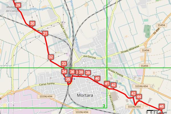
8 FB01 - THE VIA FRANCIGENA ROAD BY BIKE - LEG I Start node info Palestro, railway station End node info Tromello, railway station Total length 43.3 km Category Cycling Suggested type of bycicle Hybrid Cycle time 02:12 (hh:min) Uphill 46 m Downhill 72 m Max height 121 m Difficulty by cycle Easy Coated 64 % Offroad 28 % Mountain track 7 % Cyclability 100 % On cycle road 3 % Signals <p>not available in the cycling track, only partially available in the pedestrian track</p> Suggested time <p>all year long</p> How to arrive <p>fs Railway Line Pavia-Mortara-Vercelli</p> How to get back <p>fs Railway Line Pavia-Mortara-Vercelli</p> Description From Palestro the path follows the bends of the river Sesia up to Rivoltella and Robbio, home of the S. Valeriano monastery and the S. Pietro church. In past times there was a "Hospicium" (hospice) nearby. From the Sant'Albino and S. Croce abbeys in Mortara, mandatory stops for any real pilgrim, the path then carries on up to Tromello. Elevation Ref. Km partial Km total Description From the station take the road ahead of you 8
9 Ref. Km partial Km total Description at the traffic light by the crossroads go straight for the centre of Palestro cross the centre and keep the left on via Garibaldi at the fork at the stop sign go straight for Rosasco and at the Y junction immediately after, keep to the right follow the beautiful asphalt road that winds in the countryside near the Sesia river at the fork continue for Robbio and cross the hamlet of Rivoltella follow on the asphalt road for Robbio at the crossroads go straight for Robbio at the stops sign go straight and follow the signs for the centre of Robbio at the fork turn right into Rosasco continue straight on via Cernaia for Mortara at the traffic light go straight and by the old church of S. Pietro keep to the right shortly after turn left for the Ponella farm on via Roggetta at the stop sign go straight across the crossroads and when the asphalt road ends go straight on the long stretch of dirt terrain ride through a railway crossing and at the fork, where the dirt terrain ends, go straight at the following fork go straight at the stop sign turn right for Cilavegna and ride past the Agogna stream at Nicorvo turn left and follow the signs for Cilavegna and the Afficciati farm at the square turn right for Mortara ride past a crossroads of country tracks and continue on the Provincial road continue on the Provincial road towards Albonese ride past a country track on the right and continue on the Provincial road at the fork turn right on the dirt road for the Afficiati farm at the farm turn left on a grass-covered country track 9
10 Ref. Km partial Km total Description at the first little bridge cross the irrigation ditch on the right go straight at the two crossroads at the fork go straight towards the cluster of houses nearby the dirt terrain ends shortly after at the church of S. Maria del Campo go straight cross the railway crossing on the right at the fork go straight at the stop sign go straight into via A. da Cantiano get to the back of the Mortara railway station and turn right at the square, near the water tower, go straight for the dead end road take the bicycle and pedestrian underpass and go straight as you exit get to the Mortara railway station and turn right onto C.so Garibaldi continue on C.so Garibaldi towards the centre at the church of San Lorenzo continue on C.so Cavour keep to the right at the Town Hall at the fork go straight for S. Albino on C.so Cavour, then take the bicycle path on the other side of the road go straight at the roundabout go straight into via S. Albino Alcuino on the bicycle path follow the bicycle path on the right and cross the underpass at the abbey of S. Albino turn right on the unpaved road that runs along a pond at the fork keep to the right ride past the railway crossing and turn left at the fork by a group of trees keep to the left 10
11 Ref. Km partial Km total Description at the fork immediately after keep to the right at the fork before a farm turn left go straight at the Cavour channel at the fork go straight for the group of trees at the T junction take a right and into a wide white road at the crossing by the fishing reservoir go straight at the fork before the farm turn right at the locks cross the Cavour canal and turn left into the towpath at the following crossroads by a brickwork bridge go straight by another lock move to the other side of the canal go straight at the following crossroads at the crossroads take a left on the asphalt road at the fork go straight for Tromello and follow the road that winds among the poplar groves at the stop sign cross the State road and continue straight for the centre of Tromello at the bottom of via Corridoni turn right and ride on a short stretch of via Dante against the traffic, making sure you walk your bike let's proceed straight on as far as piazza Campegi, then turn left at the traffic light turn left for Mortara immediately after turn right into via Roma and get to the railway station end 11


12 Overview map Detail map #1 12


13 Detail map #2 Detail map #3 13


14 Detail map #4 Detail map #5 14

15 Detail map #6 Detail map #7 15


16 Detail map #8 Detail map #9 16


17 Detail map #10 Detail map #11 17
18 FB03 - THE VIA FRANCIGENA ROAD BY BIKE - LEG III Start node info Pavia, railway station End node info Lambrinia, railway station Total length 51.5 km Category Cycling Suggested type of bycicle Hybrid Cycle time 02:48 (hh:min) Uphill 65 m Downhill 80 m Max height 76 m Difficulty by cycle Easy Coated 78 % Offroad 21 % Mountain track 1 % Cyclability 100 % On cycle road 7 % Signals <p>none</p> Suggested time <p>all year long</p> How to arrive <p>fs Railway Lines Milan-Genoa, Alessandria-Pavia, Vercelli-Pavia and Codogno-Pavia</p> How to get back <p>fs Railway Line Codogno-Pavia, Lambrinia station</p> Description This path leads out from Pavia and alternates cycling track to ordinary (motorised traffic) road sections up to S. Leonardo, where a narrow country road takes us to Belgioioso. After having visited the 14th century castle of the town the path leads to S. Zenone from where the path takes us to Lambrinia via the Po riverside. The final part of the path, from Lambrinia to Corte S. Andrea, is made via unsurfaced roads. Elevation Ref. Km partial Km total Description from the railway station take viale V. Emanuele II right in front of you 18
19 Ref. Km partial Km total Description in Piazzale Minerva turn right on the bicycle lane of Viale della Libertà at the bottom of the avenue before the bridge keep to the left on lungo Ticino Visconti and get on the broad sidewalk near Ponte Coperto continue on the wide sidewalk that follows the course of river Ticino after the Imbarcadero floating bar do right towards river Ticino follow the bicycle path and keep to the right after the footbridge at the end of the bicycle path near the locks on Naviglio Pavese go straight along the water at the crossroads turn right into V.le dei Partigiani after the church of S. Pietro in Verzuolo, and before the traffic light, turn right into Francana go straight to the bottom and take the dirt road ahead of you at the end of the dirt road turn right and immediately left to take the gravel ramp at the asphalt road turn right at the stop sign turn right take the bicycle path at the end of the bicycle path continue on the asphalt road keep to the left at the fork at the stop sign turn right for Broni an the trafficked State road at the roundabout continue on Valle Salimbene a small bicycle path begins shortly after at the end of the bicycle path, by the fork for S. Leonardo go straight for Linarolo at the fork just out of the village go straight for Linarolo at the following fork go straight again for Linarolo at the fork go straight for the no entry sign and immediately after take a right for S. Giacomo on the dirt road at the end of the dirt stretch keep to the left 19
20 Ref. Km partial Km total Description ride past S. Giacomo and its beautiful namesake church and continue on the main road past the side roads go straight towards the Castle of Belgioioso nearby ride past S. Margerita and after a slight ramp get to the Castle of Belgioioso; at the traffic light turn right on the trafficked State road ride past the traffic light at the crossroads at the fork turn right and follow the signs for Torre de' Negri at the fork continue for Torre de' Negri continue on the asphalt road towards Sostegno ride past the village, keep going on the asphalt road, get to Sostegno and at the crossroads go ahead for Spessa go straight and enter Spessa by P.zza A. Scuri turn left into via Roma by the City Hall take a left into via dei Caduti at the Provincial road go straight for S. Zenone al Po cross the small centre and take the bicycle path the bicycle path ends at the cemetery of S. Zenone after the bridge over river Olona turn right for Zerbo immediately after take the dirt bank of river Po on the right and go past a barrier pass another barrier where the dirt road ends at the fork ride past the two barriers and continue on the bank for a long stretch at Mezzano cross the asphalt road and go straight on the bank cross State road 412 taking extra care for passing vehicles and go straight on the bank ride for a very long asphalt stretch on the bank of the Po, past many barriers; once at Chiavica del Reale, go straight on the bank as its terrain becomes dirt the dirt road ends at Castellaro 20

21 Ref. Km partial Km total Description immediately after, at the bend by the lock in the river, turn right on the unpaved road continue on the unpaved road towards river Lambro the unpaved road runs along river Lambro; after the railway underpass turn left end Overview map 21


22 Detail map #1 Detail map #2 22


23 Detail map #3 Detail map #4 23


24 Detail map #5 Detail map #6 24


25 Detail map #7 Detail map #8 25


26 Detail map #9 Detail map #10 26


27 Detail map #11 Detail map #12 27
FB01 - THE VIA FRANCIGENA ROAD BY BIKE - LEG I
 FB01 - THE VIA FRANCIGENA ROAD BY BIKE - LEG I Start node info End node info Total length Category Suggested type of bycicle Cycle time Uphill Downhill Max height Difficulty by cycle Coated Offroad Mountain
PO01 - THE PO BETWEEN THE LODI AND CREMONA AREAS
 PO01 - THE PO BETWEEN THE LODI AND CREMONA AREAS Start node info End node info Total length Category Suggested type of bycicle Cycle time Uphill Downhill Max height Difficulty by cycle Coated Offroad Cyclability
PV05 - FROM VIGEVANO AND THE SFORZESCA ALONG THE E1 PATH
 PV05 - FROM VIGEVANO AND THE SFORZESCA ALONG THE E1 PATH Start node info End node info Total length Category Suggested type of bycicle Cycle time Uphill Downhill Max height Difficulty by cycle Coated Offroad
MN05 - THE MORAINIC CORRIDOR
 MN05 - THE MORAINIC CORRIDOR Start node info End node info Total length Category Suggested type of bycicle Cycle time Uphill Downhill Max height Difficulty by cycle Coated Offroad Cyclability On cycle
PO06 - THE DESTRA PO CYCLING TRACK
 PO06 - THE DESTRA PO CYCLING TRACK Start node info End node info Total length Category Suggested type of bycicle Cycle time Uphill Downhill Max height Difficulty by cycle Coated Offroad Cyclability On
The Po cycling track
 The Po cycling track An enrapturing path, seemingly suspended over time: the river's silence rules supreme as countless rows of poplar trees reaching out to infinity and the flight of the herons accompany
Husthwaite to Byland Abbey
 Husthwaite to Byland Abbey This walk begins with a loop round the village of Husthwaite and continues towards Coxwold along a disused railway line, which is now a right of way. It passes through Coxwold
Thornton le Dale Walks
 Thornton le Dale Walks A collection of walks in and around the village Thornton le Dale Traders Forum www.visitthorntonledale.co.uk Thornton le Dale Walks Walk 1: Beck Isle Cottage and All Saints Church
The Hundred Parishes
 The Hundred Parishes Walks from railway stations number 9 6.4 miles (10kms) from Bishop s Stortford to Stansted Mountfitchet Start: Bishop s Stortford station (Grid Reference TL492209) (ample parking and
Thornton le Dale Walks
 Thornton le Dale Walks A collection of circular walks in, and around, the village www.visitthorntonledale.co.uk Thornton-le-Dale Traders Forum and Thornton le Dale Parish Council 1 Thornton le Dale Circular
HARDMOORS 26.2 WHITE HORSE HALF ROUTE DESCRIPTION - 018
 HARDMOORS 26.2 WHITE HORSE HALF ROUTE DESCRIPTION - 018 Follow Cleveland Way, keeping to the left hand path (right path is a bike trail) Ignoring any turnings to the left or right At path junction (after
Hammer Vale and Linchmere Common
 point your feet on a new path Hammer Vale and Linchmere Common Distance: 9 km=5½ miles or 6 km=3¾ miles easy walking with one steep section Region: Hampshire, West Sussex Author: Botafuego Refreshments:
Harlington - Sharpenhoe - Pulloxhill
 Harlington - Sharpenhoe - Pulloxhill ID: 3676, Distance: 8 miles, Height gain: 140 Metres, Map: Explorer 193 Luton & Stevenage, Contributor: Dennis Jeanes Duration: 3 Hours 27 Mins Features Church,Great
Danbury Words and pictures by Laurie Page of the Public Rights of Way team at Essex County Council.
 Danbury Words and pictures by Laurie Page of the Public Rights of Way team at Essex County Council. An undulating walk from Danbury village to the bluebells at the National Trust property of Blakes Wood.
Walk Description. Directions
 Title: Saffron Trail: Battlesbridge to Chelmsford Distance: 14¾ miles Time taken: 6 hours Start Point: Outside the Barge Inn, Battlesbridge OS Explorer Map: 175 & 183 Grid Ref.: TQ 780 947 Transport: Rail:-
The Mendip Way. Route Directions and Maps Wells to Frome
 The Mendip Way Route Directions and Maps Wells to Frome Website: www.mendiphillsaonb.org.uk Email: mendip@mendiphillsaonb.org.uk Facebook & Twitter: @MendipHillsAONB Phone: 01761462338 1 Wells to Shepton
Map and Directions. Walking to raise funds for North London Hospice #bigfunwalk
 Map and Directions Walking to raise funds for North London Hospice 020 8446 2288 www.bigfunwalk.co.uk #bigfunwalk BFW_MAP_2018.indd 1 22/04/2018 21:32 START The Blue Line is the regular route and the Red
Dorridge & District Residents Association A Walk Along The Green Belt From Dorridge to Catherine-de-Barnes
 Dorridge & District Residents Association A Walk Along The Green Belt From Dorridge to Carine-de-Barnes The starting section of this walk through open fields would be destroyed by building of motorway
Cycle Tendring. Great Bicycle rides around the Brightlingsea and Manningtree area
 2 Cycle Tendring Bicycle rides around the Brightlingsea and Manningtree area Cycle Tendring Why not discover and explore the beauty of the Tendring Peninsula by bike? There s nothing like following the
WETHERBY CIRCULAR by Tania Dickinson
 WETHERBY CIRCULAR by Tania Dickinson This walk in lower Wharfedale includes a disused railway line at the beginning and riverside at the end, with parkland, fields, woodland and villages in between. Distance
Cycle Tendring. Great Bicycle rides around the Harwich, Manningtree and Mistley area
 Great Bicycle rides around the Harwich, Manningtree and Mistley area Why not discover and explore the beauty of the Tendring Peninsula by bike? There s nothing like following the beautiful coastline or
Italy Rivers of the Piedmont Bike Tour 2018 Individual Self-Guided Tour 8 days / 7 nights
 Italy Rivers of the Piedmont Bike Tour 2018 Individual Self-Guided Tour 8 days / 7 nights Starting from Turin you will discover a different side to the Piedmont region. Towns such as Vercelli, Casale and
LOCAL CIRCUIT EM1: EAST MALLING & BARMING HEATH. N 2m ROADS: Significant roads PATHS: Starting direction Barming Longsole Mission Church
 Ditton Church Scott Close LOCAL CIRCUIT EM1: EAST MALLING & BARMING HEATH 6 Community Centre F Open fields (see 'Introductory Notes') 1m 88 Direction label (as in the walk notes) East Malling Church -
BALCOMBE AND ARDINGLY RESERVOIR, WEST SUSSEX
 BALCOMBE AND ARDINGLY RESERVOIR, WEST SUSSEX 7 miles Circular 4 hours 080816 Challenging Terrain Hi, I'm Luke and this is my West Sussex Weekends walk It's a 7 mile loop from Balcombe rail station, taking
This walk description is from happyhiker.co.uk
 This walk description is from happyhiker.co.uk Pendle Hill Walk From Barley Starting point and OS Grid reference Ordnance Survey map Distance Traffic light rating Barley village honesty box car park OS
Ovington and Itchen Stoke
 Trail Activity Type Terrain Author Distance Ascent Location : HAMPTR0057 : Walk : Pub : Towpaths and Cycle Tracks : Peter Carne : 1.4 miles / 2.2 kms : 62 feet / 19 metres : SU560318 / SO24 0RE Bush Inn,
Gainsborough and Fledborough Circular
 Trent Vale Cycle Route TVCR18 Gainsborough and Fledborough Circular Gainsborough Old Hall. One of the biggest and best preserved Medieval Manor Houses in England. Start Point: Gainsborough Marshall s Yard
Start / Finish. Version 2
 Start / Finish Version 2 Gosford (Start) to Woy Woy Head South down Etna Street, crossing Henry Parry Drive, then Mann St, Gosford, where Etna St becomes Racecourse Road. Follow this road all the way
Bonnie Prince Charlie Walk
 Bonnie Prince Charlie Walk A waymarked route from Ashbourne to Derby to celebrate the 60th anniversary (1995) of the formation of the Ramblers' Association. This route follows the general direction of
Chichester Harbour. A Walker s Guide
 A Walker s Guide - Chichester Harbour Chichester Harbour A Walker s Guide Chichester Harbour is an Area of Outstanding Natural Beauty on the south coast of Britain. Virtually flat with far reaching sea
TOUR INFO GETTING THERE START CHARACTERISTICS VARIATIONS HISTORY ROADBOOK ALTITUDE
 TOUR INFO GETTING THERE START CHARACTERISTICS VARIATIONS HISTORY ALTITUDE TOUR INFO RIDING TIME Riding time at Riding time at Riding time at 14 Riding time at 16 Riding time at 18 Riding time at 20 % of
Clyde Walkway Community Links: Rosebank Circular via Ashgill and Dalserf
 Clyde Walkway Community Links: Rosebank Circular via Ashgill and Dalserf Rosebank Circular via Ashgill and Dalserf Digital Trail Difficulty (out of 3) 1 Distance 7 km / 4.35 miles. Time 2 hours Terrain
Walk WOC 02 Location: Usk Reservoir
 5 Walk WOC 02 Location: Usk Reservoir Directions: Right out of castle, first left opposite Tafan y Garreg pub, over the mountain on single track roads for about 8 miles. At first T junction you come to,
Cilgerran Wildlife Park Circular Walk
 Walking embrokeshire Cilgerran Wildlife ark Circular Walk It s good to walk, so why not step out and sample some of the walks your neighbourhood has to offer. This pleasant and interesting walk which starts
9.5 km Circular 3 hours
 MEDIEVAL WAVERLEY Challenging Terrain A 6 mile (9.5km) undulating circular walk from Tilford village passing close to The Sands village and the historic ruins of Waverley Abbey. From the top of Crooksbury
Route: Skewsby Foulrice Stearsby
 Route: Skewsby Foulrice Stearsby Distance: 7 miles Map: Explorer: 300 Howardian Hills & Malton Start (OS ref): SE625710 Park in the village of Skewsby. Walk east out of the village to the T-Junction and
10 km Circular 3 hours
 FRIMLEY AND FRIMLEY GREEN 10 km Circular 3 hours Easy Terrain 250716 A 10km (6 mile) circular walk exploring the canal towpath, riverside path, woodland, heath and small settlements around Frimley in Surrey.
Approximate distance: 10 miles For this walk we ve included OS grid references should you wish to use them. Start. End
 Approximate distance: 10 miles For this walk we ve included OS grid references should you wish to use them. 2 3 Start End 1 N W E S Reproduced by permission of Ordnance Survey on behalf of HMSO. Crown
2.0 Existing Conditions
 20 2.0 Existing Conditions 2.1 Land Use, Future Growth Patterns, Physical Barriers Geographic Overview Sutter County s land use pattern is characterized by extensive agricultural areas, significant natural
Falls Lake Trail (A part of the NC Mountains-to-Sea Trail) East to West
 East to West") Falls Lake Trail (A part of the NC Mountains-to-Sea Trail) East to West Section 1 (Falls of the Neuse Rd to Raven Ridge Rd) 0.0 mi Parking area of the Tailrace Fishing Area, just below the dam, off Falls
Falls Lake Trail (A part of the NC Mountains-to-Sea Trail) East to West Section 1 (Falls of the Neuse Rd to Raven Ridge Rd) 0.0 mi Parking area of the Tailrace Fishing Area, just below the dam, off Falls
Year of Mercy Pilgrimage St Ignatius Toowong to the Cathedral of St Stephen
 Year of Mercy Pilgrimage St Ignatius Toowong to the Cathedral of St Stephen Distance Directions Photograph 0.0km Start St Ignatius Church, Kensington Terrace, Toowong. Park any vehicles in nearby streets
LDWA SOUTH DOWNS MARATHON 13 th MAY 2018
 AHD ahead SDW South Downs Way BL/BR bear left/bear right TL/TR turn left/turn right X cross LEG 1 - EAST DEAN to WP1 NORTON GR 470019. Open 1030 to 1300. 9.7 miles. 1.1 From village hall TL and walk to
The Year Of Mercy Pilgrimage Sts Peter and Paul s Church, Bulimba To The Cathedral of St Stephen
 The Year Of Mercy Pilgrimage Sts Peter and Paul s Church, Bulimba To The Cathedral of St Stephen Dist Route Photos Photos 0.0km St Peter and Paul s Church, 235 Riding Rd & Cnr Main Ave, Balmoral. http://www.bulimbacatholic.com/
There are toilets at Manningtree Station, Flatford (close to the hump back bridge) and in Dedham.
 and in Dedham.") Arriving by Train Main Features of the Walk Outline Route Employs particularly attractive paths, many of which offer impressive views across Dedham Vale. Includes a section along the tidal section of the
Arriving by Train Main Features of the Walk Outline Route Employs particularly attractive paths, many of which offer impressive views across Dedham Vale. Includes a section along the tidal section of the
LDWA SOUTH DOWNS MARATHON
 AHD ahead SDW South Downs Way BL/BR bear left/bear right TL/TR turn left/turn right SP signpost/fingerpost X cross LEG 1 - EAST DEAN to WP1 NORTON GR 470019. Open 1030 to 1300. 9.6 miles. 1.1 From village
8 Miles Circular 4 hours
 VISIT RYEDALE HELMSLEY AND RICCAL DALE 8 Miles Circular 4 hours 090616 Challenging Terrain An 8 mile (13km) circular walk from the market town of Helmsley in Ryedale. The route heads out across sheep pastures
Fish Lake Team Relay Course Information 2016
 Fish Lake Team Relay Course Information 2016 Fish Lake Team Relay Course Information 2016 The Fish Lake Team Relay begins at Fish Lake Lodge on the shores of beautiful Fish Lake located in Sevier County,
Clyde Walkway Community Links: Crossford Stonebyres Nemphlar- Kirkfieldbank
 Clyde Walkway Community Links: Crossford Stonebyres Nemphlar- Kirkfieldbank Crossford Stonebyres Nemphlar - Kirkfieldbank Digital Trail Difficulty (out of 3) 2 Distance 1. Crossford to Kirkfield Bank Bridge
9.5 km Circular 3 hours
 RANMORE CIRCULAR A 6 mile (9.5km) circular walk from Boxhill and Westhumble Station in the village of Westhumble, passing through part of the Polesden Lacey Estate, Ranmore Common and Denbies Vineyard.
RILLINGTON TO MALTON by Tania Dickinson
 RILLINGTON TO MALTON by Tania Dickinson This walk takes you from the Vale of Pickering up on to the Wold scarp, before dropping down again through the pretty village of Settrington and joining the Centenary
Road Traffic Signs in Germany
 Warning signs Road Traffic Signs in Germany General danger Curve left Curve right Double curve Double curve Accident hazard Sliding danger Winter sports along road Soft shoulder Rough road edge Steep upgrade
Stage 5 Overview. 5 miles: Out of cricket club, follow path under A413 (by stream MIND YOUR HEAD!), and onto Old Amersham Rd
, and onto Old Amersham Rd") Stage 5 Overview Start time: 12:53 Saturday Distance: 13.5 miles Emergency: 07966 542315 Start: From Common Road, left to path then join Cockpit Road, then over BUSY ROAD to Heath End Road. 2 miles: off
Stage 5 Overview Start time: 12:53 Saturday Distance: 13.5 miles Emergency: 07966 542315 Start: From Common Road, left to path then join Cockpit Road, then over BUSY ROAD to Heath End Road. 2 miles: off
Oldbury & Littleton, South Gloucestershire
 Oldbury & Littleton, South Gloucestershire Starts at Church Lane, Oldbury. BS35 1QF 2 hours 0 minutes 5.2miles 8.4km Easy ID: 0.2468 Developed by: GEOFF MULLETT Checked by: Marion Stone www.ramblersroutes.org
A mainly flat walk along the Peak Forest Canal to Castle Hill and returning along the River Tame via Hulmes Wood and Haughton Dale.
 Walk 9 Haughton Green, Peak Forest Canal, Castle Hill, Hulmes Wood, River Tame, Haughton Dale Circular Miles: 3.9 Time: 1 Hour 30 Minutes Grade: Easy To Moderate Starting Point: Junction Of Gibraltar Lane/Newport
Walk 2: Beamsley Beacon and Bolton Abbey
 Walk 2: Beamsley Beacon and Bolton Abbey Start and Finish: The Memorial Hall, Main Street, Addingham, LS29 0LZ, SE 079 497 The shortest walk is about 5½ miles (8.8km) The medium Walk is about 8¼ miles
NETTLESTEAD & YALDING
 NETTLESTEAD & YALDING ULL CIRCUIT - Sheet 1 (first and last sections) Open fields (see 'Introductory Notes') 88 Direction label (as in the walk notes) ROADS: 81 10m Significant roads Redhill arm North
Tenerife Sur: Short Walks Under 10 km. Santiago del Teide Almond Blossom
 Tenerife Sur: Short Walks Under 10 km Santiago del Teide Almond Blossom Route Summary This delightful circular walk is especially beautiful when the almond trees are in flower during January and February
Traffic Signs and Signals
 CHAPTER FOUR Traffic Signs and Signals Traffic signs control traffic flow, making streets and highways safer for drivers, bicyclists and pedestrians. These signs, which are posted by the Indiana Department
Tuskendammen - Oenkerk
 MAP 44 6,1 KM Tuskendammen - Oenkerk Follow the street. At the next intersection, go straight onto Klaas Douwesweg. Take the first forest path on the right, pass through cycle barriers. At the intersection,
Village Amble VILLAGE AMBLE. Turunç Walks. .kml file of this route. Start point: Turunç Mosque End point: Turunç Mosque
 Turunç Walks VILLAGE AMBLE Village Amble Category: Easy Total distance: 4.2 km Moving time: 2 hours Start point: Turunç Mosque End point: Turunç Mosque Downloads:.pdf this document.gpx file of this route.kml
Walks from Orta San Giulio
 Walks from Orta San Giulio www.lakeorta.com/docs Below are described four walks in the area, which should be undertaken in conjunction with a map (please do not rely solely on the sketch-maps included
Italy Tuscany in One Hotel Bike Tour 2018 Individual Self-Guided 8 days/7 nights
 Italy Tuscany in One Hotel Bike Tour 2018 Individual Self-Guided 8 days/7 nights Traveltripjourney.blogspot.com Simply thinking about this popular region puts a smile on a lot of people s faces! The many
Dyrham and Hinton Parish Walks
 Dyrham and Hinton Parish Walks A series of five walks in the parish, exploring most of the public footpaths. By John Miller Each walk is described in detail, with a complete map, to provide a handy guide
Fish Lake Team Relay Course Information
 Fish Lake Team Relay Course Information Fish Lake Team Relay Course Information The Fish Lake Team Relay begins at Fish Lake Lodge on the shores of beautiful Fish Lake located in Sevier County, Utah. The
Walk 3 - Woodbridge and Melton A Walk Round Waldringfield by Sue and Jim Stacey. Woodbridge. shopping centre, cafes, toilets etc. tide mill.
 Walk 3 - Woodbridge and Melton A Walk Round Waldringfield by Sue and Jim Stacey. road with roundabout church railway with station walk route showing description direction track, wide path, bridlepath footpath
Bakewell Club Site - Robin Hood's Stride
 Bakewell Club Site - Robin Hood's Stride Camping and Caravanning Route Summary A circular walk with fabulous views winding it's way through the beautiful White Peak scenery. Points of interest include
A circular walk of or km (2 1 4 or miles)
") Grantham A circular walk of 3 3 4 or 5 3 4 km (2 1 4 or 3 1 2 miles) Introduction This relatively short circular walk, which starts in the middle of Grantham, offers plenty of variety. The route takes
Grantham A circular walk of 3 3 4 or 5 3 4 km (2 1 4 or 3 1 2 miles) Introduction This relatively short circular walk, which starts in the middle of Grantham, offers plenty of variety. The route takes
GREEN ITINERARIES ITINERARY NO. 3C: MUNICIPALITY OF MONTAIONE
 GREEN ITINERARIES ITINERARY NO. 3C: MUNICIPALITY OF MONTAIONE LEGEND: W.P.: WAY POINTS DIR: DIRECTION R: RIGHT L: LEFT I.N.V.: (RETE ESCURSIONISTICA) ITINERARI NEL VERDE [(EXCURSION NETWORK) GREEN ITINERARIES]
THE PONTON PLOD - 27 MILE ROUTE
 THE PONTON PLOD - 27 MILE ROUTE Emergency Phone Number 07771 813514 Abbreviations: BW Bridleway X Cross immd immediately FP Footpath TL Turn left L Left thro through KG Kissing Gate TR Turn right R Right
Hitchin Nomads Cycling Club
 Hitchin Nomads Cycling Club Risk Assessment of Course Course Identification 1U/10 10 Miles - Southill / Old / Warden / Ireland Circuit Reviewed By Nick Hickman Reviewed On 13/01/2018 Course Details START
1. Kala Nera Milies Kala Nera
 1. Kala Nera Milies Kala Nera A beautiful and varied walk from Kala Nera, a tourist seaside village, to Milies which lies 400 metres higher up. From there it proceeds back down to Kala Nera along another
Slindon Folly - South Downs, West Sussex
 Slindon Folly - South Downs, West Sussex Starts at Park road-side near entrance to Slindon College 2 hours 15 minutes 4.5miles 7.2km Easy ID: 0.1598 Developed by: Chris Mumford Checked by: Rockpit www.ramblersroutes.org
10 Miles Circular 5 hours
 VISIT RYEDALE PICKERING AND CAWTHORN CAMPS 10 Miles Circular 5 hours Moderate Terrain 120616 A 10 mile (16km) there and back walk from the market town of Pickering in Ryedale. The route heads north through
Walking Pilgrimage to Rome on the Via Francigena. Catholic Charities of California invites you to join a seven day walking pilgrimage to Rome:
 Walking Pilgrimage to Rome on the Via Francigena Catholic Charities of California invites you to join a seven day walking pilgrimage to Rome: 2017 June 3-10, 2017 Full September 14-21, 2017 2018 June 3-10,
London to Southend-on-Sea Trek map
 FIGHT FOR EVERY HEARTBEAT London to Southend-on-Sea Trek map Route stats: 100 km (62 miles) with metres of climbing Start: Fulham Palace 9:00am Half Way / Start for 50km: CEME Centre 9.00pm Finish: Southend-on-sea
TIMEBALL and TELEGRAPH TRAIL
 TIMEBALL and TELEGRAPH TRAIL A 97 mile walk between Deal & Greenwich Prominent on Deal seafront is a tall building with a large black ball on the roof. This is the Timeball Tower. The current building
Welsh Newton and Woodland
 Welsh Newton and Woodland This is a 8.2km miles (approx) walk which will take about 2.5 hours at a relaxed and leisurely pace. There are a few hills but no steep inclines. Start at Llangrove bus stop and
NEWLANDS CORNER AND ST MARTHAS
 NEWLANDS CORNER AND ST MARTHAS 10k CIRCULAR ROUTE 2½-3HRS GU4 8SE From Newlands Corner on the North Downs just outside Guildford, you can enjoy one of the most beautiful panoramas of quintessential English
Castro Valley Municipal Advisory Council March 19, 2018
 Castro Valley Municipal Advisory Council March 19, 2018 1 Background 2 Draft Bicycle Vision and Pedestrian Networks 3 Next Steps 4 Updates Agenda 2 PROJECT AREA: Unincorporated Areas of Alameda County
Walk 7: Watchet to washford
 Walk 7: Watchet to washford Length: Moderate - 7.5 miles / 12 km Good For: Theme: History Duration: 2-3 hours depending on speed of walking Notes: This is a moderate to difficult walk in places, with steps,
SITE OBSERVATION FORM
 Sequential # Site ID: Sequential Number in pencil Injury Site B. Additional Site D. Additional Site E. Site type will be completed by the Study Coordinator after the Observation Form is completed. SITE
Pull the gate towards you and ride through. The third gate takes you onto Hound House Road. Watch out for traffic. 4
 PEASLAKE TO FARLEY HEATH AND WINTERFOLD 12k CIRCULAR ROUTE 2HRS GU5 9QW This interesting trail takes you across a variety of terrain, from the sandstone of Pitch Hill, across open farmland with fabulous
Italy Prosecco (Veneto) in One Hotel Bike Tour 2018 Individual Self-Guided 7 days/6 nights
 in One Hotel Bike Tour 2018 Individual Self-Guided 7 days/6 nights") Italy Prosecco (Veneto) in One Hotel Bike Tour 2018 Individual Self-Guided 7 days/6 nights The area between the rivers Piave and Sile seems to be made for a cycle tour. Based in a beautiful hotel you will
Italy Prosecco (Veneto) in One Hotel Bike Tour 2018 Individual Self-Guided 7 days/6 nights The area between the rivers Piave and Sile seems to be made for a cycle tour. Based in a beautiful hotel you will
Italy Tuscany in One Hotel Bike Tour 2019 Individual Self-Guided 8 days/7 nights
 Italy Tuscany in One Hotel Bike Tour 2019 Individual Self-Guided 8 days/7 nights Traveltripjourney.blogspot.com Simply thinking about this popular region puts a smile on a lot of people s faces! The many
Hitchin Nomads Cycling Club
 Hitchin Nomads Cycling Club Risk Assessment of Course Course Identification 1U/25 25 Miles - Southill / Old Warden Reviewed By Paul Riley Reviewed On 02/01/2018 Course Details https://www.plotaroute.com/route/346809
A Walk from Our Lady of Victories Church, Bowen Hills to The Cathedral of Saint Stephen
 A Walk from Our Lady of Victories Church, Bowen Hills to The Cathedral of Saint Stephen 1 0.0km 30m 185m 270m From the Start to Breakfast Creek Rd is 8 minutes This pilgrimage walk should take the average
Cycle routes from Guildford
 Cycle routes from Guildford The following five pages give practical information about following the main cycle routes from Guildford. There are now several good trafficfree routes in the area, and Guildford
Beautiful Walks from the Blue Ball Inn
 Walk No. 7 COAST AND VALLEY WALK Countisbury, Glenthorne, County Gate, Brendon, Rockford and Wilsham 10 MILES APPROX. Walking time 5 hours approx. (not including breaks)> OS Sheet 64/74 Lynton and Lynmouth.
Green Man Ultra Route Directions 2018
 Green Man Ultra Route Directions 2018 Start-CP1 (9 miles) Community Forest Path (CFP) Frome Valley Way (FVW) From the starting line cross the playing fields diagonally to the metal gates in the hedge lined
Controlled. Semi-Controlled PAGE 01 CHAPTER 12 INTERSECTIONS
 PAGE 01 CHAPTER 12 INTERSECTIONS You will cross many intersections while driving. Intersections are especially dangerous because vehicles are crossing each other s driving path. Many crashes happen at
Walk Description. Directions
 Title: East Hanningfield Distance: 8 miles / 9 miles Time taken: 3-3½ hours Location: 5 miles south east of Chelmsford Parking: Free car park off The Tye, East Hanningfield, next to the primary school
Christchurch to Hengistbury Head
 Last checked 6 June 2018 Document last updated: 13 July 2018 This document and information herein are copyrighted to Saturday Walkers Club. If you are interested in printing or displaying any of this material,
Falls Lake Trail (A part of the NC Mountains-to-Sea Trail) East to West
 East to West") Falls Lake Trail (A part of the NC Mountains-to-Sea Trail) East to West Section 1 (Falls of the Neuse Rd to Raven Ridge Rd) 0.0 mi Parking area of the Tailrace Fishing Area, just below the dam, off Falls
Falls Lake Trail (A part of the NC Mountains-to-Sea Trail) East to West Section 1 (Falls of the Neuse Rd to Raven Ridge Rd) 0.0 mi Parking area of the Tailrace Fishing Area, just below the dam, off Falls
Leg #1 (GUNLOCK AND LOADED) Miles
 Miles") Leg #1 (GUNLOCK AND LOADED)- 6.07 Miles Difficulty: Easy to Moderate This is a nice leg for those who like running downhill. It s a beautiful run down the Santa Clara River canyon to the point where the
Leg #1 (GUNLOCK AND LOADED)- 6.07 Miles Difficulty: Easy to Moderate This is a nice leg for those who like running downhill. It s a beautiful run down the Santa Clara River canyon to the point where the
ST. AGNES. you cannot put a time limit on beauty.
 ST. AGNES CIRCULAR WALKS AROUND There are many enjoyable and picturesque walks around St. Agnes most are signposted and are featured on the St. Agnes Mini-guide map. Because most of our footpaths are in
Gravel Bike Guide Haywood County
 Gravel Bike Guide Haywood County Haywood County is an ideal place for bicycling on gravel roads, because 37% or 129,994 acres of Haywood County is federal property, including portions of the Pisgah National
YHA RAVENSTOR Ideas for walks in the local area
 YHA RAVENSTOR Ideas for walks in the local area How to use this book This book contains some suggestions for enjoyable walks in the countryside immediately surrounding YHA Ravenstor. We hope that our guests
Shepherdswell - Dover
 Shepherdswell - Dover The North Downs Way > Shepherdswell to Dover Introduction This part of the path is slightly different in character from most other parts of the path since it spends much of the time
Redesdale Arms. A Trio of Walks
 Redesdale Arms A Trio of Walks Welcome to The Redesdale Arms Hotel The award winning 34 bedroom Redesdale Arms Hotel sits at the gateway to the Cotswolds in the High Street of the historic town of Moreton-in-Marsh.
The Chief Commissaire and the race officials will meet team managers in the Killorglin Sports and Leisure centre at 2:00p.m.
 STAGE 1 ROADBOOK KERRY GROUP RÁS MUMHAN 2018 Race Schedule Friday 30 th March. Registration and Sign-On: Friday 30 th March. Registration and Sign-On in Killorglin Sports & Leisure Centre from 12:00 noon