PO06 - THE DESTRA PO CYCLING TRACK
|
|
|
- Eric Walsh
- 5 years ago
- Views:
Transcription
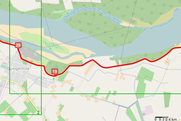
1 PO06 - THE DESTRA PO CYCLING TRACK Start node info End node info Total length Category Suggested type of bycicle Cycle time Uphill Downhill Max height Difficulty by cycle Coated Offroad Cyclability On cycle road Signals Suggested time How to arrive How to get back Ostiglia, railway station Luzzara, railway station 64.6 km Cycling Hybrid 03:34 (hh:min) 38 m 30 m 24 m Easy 76 % 24 % 100 % 1 % Available on the whole track All year long Trenitalia Railway Line Verona-Bologna, Ostiglia station FER Railway Line Parma-Suzzara Description This itinerary unfolds completely along the bankside roads of the Po river's orographical right.the banks are open to vehicular traffic, which is however very light, and some parts are closed to unauthorised traffic only for part of the year. The section from Revere to Quingentole is closed to the traffic on Saturdays and Sundays from the end of April to the end of August. From San Benedetto Po (remember to visit the magnificent Abbazia del Polirone abbey), up to the bridge near Borgoforte the itinerary is open to traffic, though traffic is quite light. This is the most spectacular section, with amazing views on the Po river and it is worth a stop especially in the area of the Manico di Paiolo. The last section, up to Luzzara, develops chiefly on unsurfaced, country roads bordering the Parco Naturale di San Colombano park. Elevation
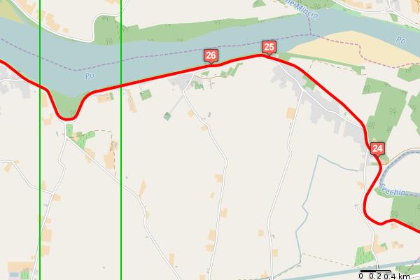
2 Ref. Km partial Km total Description from the railway station of Ostiglia take via Pertini on the left at the fork go straight into Cappuccini road go straight ahead in Cappuccini road closed to traffic continue straight ahead in Cappuccini road by the old station of Ostiglia go straight into via Roma and follow the signs for the Po bicycle path at the traffic light go straight and take the bicycle path go straight at the end of the bicycle path go straight on at the stop sign at the crossroads go straight get on the bank and follow the course of the river take the trail that leads to the bridge over the Po river and cross it at Revere by the end of the bridge take a right into the downhill alley take via Circonvallazione Po as you get on the bank at the end of the bicycle path go straight on the bank at the crossroads go straight on the bank at the stop sign go straight on the bank ride past the first fork that goes down to Pieve di Coriano keep going on the bank at the second fork by Quingentole pass the junction with a road by riding off and on the bank at Quingentole go straight on the bank at the fork go straight past the Burana water treatment plant cross the bridge over the Secchia take the left bank of river Secchia that is closed to traffic 2
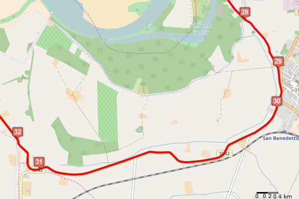
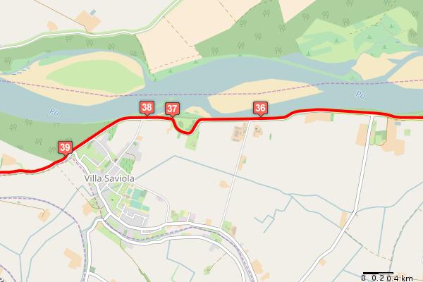
3 Ref. Km partial Km total Description at the crossroads by Mirasole go straight along the bank continue on the Argine Po Nord road ride past two forks for Brede and go straight on the bank pass the bridge and at the stop sign go straight back on the bank continue on the Argine Po Sud road towards San Benedetto Po at San Benedetto Po continue on the southward bank at the stop sign take a right into the Provincial road at the Y junction keep to the right along the bank continue along the embankment northwards by Portiolo, at the crossroads, keep to the right on the bank continue on the bank towards the bell tower of Portiolo at the stop sign take a right into Provincial road 53 and enjoy the breathtaking vista on the river by Manona go straight along the bank the bank terrain turns to dirt by Manico di Paiolo, a beautiful panoramic spot with an equipped rest area ride past the road for Villa Saviola and continue on the bank at the Villa Saviola fork continue along the embankment westwards ride past the fork for Motteggiana and continue straight on the bank as you get near the bridge of Borgoforte ride under the bridge ride past a quarry and the railway bridge then go back on the dirt bank continue on the bank as its terrain returns to asphalt for a short stretch continue on the bank that becomes dirt road ride past the fork for Torricella and continue straight keep going straight 3
4 Ref. Km partial Km total Description at the crossroads keep to the left on the bank as you get near Tabellano go straight on the bank near Tabellano continue on the bank that becomes asphalted continue on the bank as its terrain returns to dirt the asphalt stretch of the bank begins here at the picnic area in San Colombano and at the river dock continue along the Po bank southwards the Destra Po cycle track ends at Riva; continue on the bank following path n. 4 of Parco di San Colombano as you get to Luzzara by a furnace ride off the bank on the left at the T junction turn left then keep to the right to the centre of the village ride past a road on the right and turn left for the square nearby at Piazza P. Iscaro turn right towards the Torre Civica then turn left into via Filippini and ahead until the railway station end 4


5 Overview map Detail map #1 5

6 Detail map #2 Detail map #3 6

7 Detail map #4 Detail map #5 7

8 Detail map #6 Detail map #7 8

9 Detail map #8 Detail map #9 9


10 Detail map #10 Detail map #11 10


11 Detail map #12 Detail map #13 11


12 Detail map #14 Detail map #15 12
PO01 - THE PO BETWEEN THE LODI AND CREMONA AREAS
 PO01 - THE PO BETWEEN THE LODI AND CREMONA AREAS Start node info End node info Total length Category Suggested type of bycicle Cycle time Uphill Downhill Max height Difficulty by cycle Coated Offroad Cyclability
FB01 - THE VIA FRANCIGENA ROAD BY BIKE - LEG I
 FB01 - THE VIA FRANCIGENA ROAD BY BIKE - LEG I Start node info End node info Total length Category Suggested type of bycicle Cycle time Uphill Downhill Max height Difficulty by cycle Coated Offroad Mountain
PV05 - FROM VIGEVANO AND THE SFORZESCA ALONG THE E1 PATH
 PV05 - FROM VIGEVANO AND THE SFORZESCA ALONG THE E1 PATH Start node info End node info Total length Category Suggested type of bycicle Cycle time Uphill Downhill Max height Difficulty by cycle Coated Offroad
The Po cycling track
 The Po cycling track An enrapturing path, seemingly suspended over time: the river's silence rules supreme as countless rows of poplar trees reaching out to infinity and the flight of the herons accompany
MN05 - THE MORAINIC CORRIDOR
 MN05 - THE MORAINIC CORRIDOR Start node info End node info Total length Category Suggested type of bycicle Cycle time Uphill Downhill Max height Difficulty by cycle Coated Offroad Cyclability On cycle
The Via Francigena road by bike
 The Via Francigena road by bike Four days of cycling to discover the Lombard itinerary of the Via Francigena road. The itinerary is 160 km long and goes from Palestro to Piacenza, crossing the whole Pavia
Harlington - Sharpenhoe - Pulloxhill
 Harlington - Sharpenhoe - Pulloxhill ID: 3676, Distance: 8 miles, Height gain: 140 Metres, Map: Explorer 193 Luton & Stevenage, Contributor: Dennis Jeanes Duration: 3 Hours 27 Mins Features Church,Great
GREEN ITINERARIES ITINERARY NO. 3C: MUNICIPALITY OF MONTAIONE
 GREEN ITINERARIES ITINERARY NO. 3C: MUNICIPALITY OF MONTAIONE LEGEND: W.P.: WAY POINTS DIR: DIRECTION R: RIGHT L: LEFT I.N.V.: (RETE ESCURSIONISTICA) ITINERARI NEL VERDE [(EXCURSION NETWORK) GREEN ITINERARIES]
Cilgerran Wildlife Park Circular Walk
 Walking embrokeshire Cilgerran Wildlife ark Circular Walk It s good to walk, so why not step out and sample some of the walks your neighbourhood has to offer. This pleasant and interesting walk which starts
Husthwaite to Byland Abbey
 Husthwaite to Byland Abbey This walk begins with a loop round the village of Husthwaite and continues towards Coxwold along a disused railway line, which is now a right of way. It passes through Coxwold
TOUR INFO GETTING THERE START CHARACTERISTICS VARIATIONS HISTORY ROADBOOK ALTITUDE
 TOUR INFO GETTING THERE START CHARACTERISTICS VARIATIONS HISTORY ALTITUDE TOUR INFO RIDING TIME Riding time at Riding time at Riding time at 14 Riding time at 16 Riding time at 18 Riding time at 20 % of
Spain - Cycling Asturias from Mountains to Sea Bicycle Tour 2019 Individual Self-Guided 8 days / 7 nights
 Spain - Cycling Asturias from Mountains to Sea Bicycle Tour 2019 Individual Self-Guided 8 days / 7 nights The tour begins in the plains of northern Castilla with two nights in historic towns, and time
10 Miles Circular 5 hours
 VISIT RYEDALE PICKERING AND CAWTHORN CAMPS 10 Miles Circular 5 hours Moderate Terrain 120616 A 10 mile (16km) there and back walk from the market town of Pickering in Ryedale. The route heads north through
Hammer Vale and Linchmere Common
 point your feet on a new path Hammer Vale and Linchmere Common Distance: 9 km=5½ miles or 6 km=3¾ miles easy walking with one steep section Region: Hampshire, West Sussex Author: Botafuego Refreshments:
HARDMOORS 26.2 WHITE HORSE HALF ROUTE DESCRIPTION - 018
 HARDMOORS 26.2 WHITE HORSE HALF ROUTE DESCRIPTION - 018 Follow Cleveland Way, keeping to the left hand path (right path is a bike trail) Ignoring any turnings to the left or right At path junction (after
Walk Description. Directions
 Title: Saffron Trail: Battlesbridge to Chelmsford Distance: 14¾ miles Time taken: 6 hours Start Point: Outside the Barge Inn, Battlesbridge OS Explorer Map: 175 & 183 Grid Ref.: TQ 780 947 Transport: Rail:-
YHA RAVENSTOR Ideas for walks in the local area
 YHA RAVENSTOR Ideas for walks in the local area How to use this book This book contains some suggestions for enjoyable walks in the countryside immediately surrounding YHA Ravenstor. We hope that our guests
Italy Tuscany in One Hotel Bike Tour 2018 Individual Self-Guided 8 days/7 nights
 Italy Tuscany in One Hotel Bike Tour 2018 Individual Self-Guided 8 days/7 nights Traveltripjourney.blogspot.com Simply thinking about this popular region puts a smile on a lot of people s faces! The many
Danbury Words and pictures by Laurie Page of the Public Rights of Way team at Essex County Council.
 Danbury Words and pictures by Laurie Page of the Public Rights of Way team at Essex County Council. An undulating walk from Danbury village to the bluebells at the National Trust property of Blakes Wood.
The Mendip Way. Route Directions and Maps Wells to Frome
 The Mendip Way Route Directions and Maps Wells to Frome Website: www.mendiphillsaonb.org.uk Email: mendip@mendiphillsaonb.org.uk Facebook & Twitter: @MendipHillsAONB Phone: 01761462338 1 Wells to Shepton
Clyde Walkway Community Links: Nemphlar Moor Road to Braidwood
 Clyde Walkway Community Links: Nemphlar Moor Road to Braidwood Nemphlar Moor Road to Braidwood Digital Trail Difficulty (out of 3) 2 Distance Main route to Braidwood (shortest) 2.5km, 5km return. Detours
Bakewell Club Site - Robin Hood's Stride
 Bakewell Club Site - Robin Hood's Stride Camping and Caravanning Route Summary A circular walk with fabulous views winding it's way through the beautiful White Peak scenery. Points of interest include
WETHERBY CIRCULAR by Tania Dickinson
 WETHERBY CIRCULAR by Tania Dickinson This walk in lower Wharfedale includes a disused railway line at the beginning and riverside at the end, with parkland, fields, woodland and villages in between. Distance
TOUR INFO GETTING THERE START CHARACTERISTICS VARIATIONS HISTORY ROADBOOK ALTITUDE
 TOUR INFO GETTING THERE START CHARACTERISTICS VARIATIONS HISTORY ALTITUDE TOUR INFO RIDING TIME Riding time at Riding time at Riding time at 14 Riding time at 16 Riding time at 18 Riding time at 20 % of
Gravel Bike Guide Haywood County
 Gravel Bike Guide Haywood County Haywood County is an ideal place for bicycling on gravel roads, because 37% or 129,994 acres of Haywood County is federal property, including portions of the Pisgah National
Tenerife Sur: Short Walks Under 10 km. Santiago del Teide Almond Blossom
 Tenerife Sur: Short Walks Under 10 km Santiago del Teide Almond Blossom Route Summary This delightful circular walk is especially beautiful when the almond trees are in flower during January and February
Italy Tuscany in One Hotel Bike Tour 2019 Individual Self-Guided 8 days/7 nights
 Italy Tuscany in One Hotel Bike Tour 2019 Individual Self-Guided 8 days/7 nights Traveltripjourney.blogspot.com Simply thinking about this popular region puts a smile on a lot of people s faces! The many
Fertile farms in the heart of Kent
 55 55 Fertile farms in the heart of Kent A bright sunny day is perfect for enjoying the rich and fertile Kent countryside and outstanding views across the valley of the Great Stour to the North Downs.
Wallarah Coastal Walk
 Wallarah Coastal Walk 3 hrs 8.3 km Return Hard track 247m This walk starts at Caves Beach and travels south along the coastline, until reaching the Pinney s Headland Lookout. There are many opportunities
Weatherman Walking. Approximate distance: 5.5 miles For this walk we ve included OS grid references should you wish to use them. Start.
 Approximate distance: 5.5 miles For this walk we ve included OS grid references should you wish to use them. 4 1 Start End 3 2 N W E S Reproduced by permission of Ordnance Survey on behalf of HMSO. Crown
Walking Pembrokeshire.
 Walking Pembrokeshire Canaston Woods Walk It s good to walk, so why not step out and sample some of the walks your neighbourhood has to offer. This pleasant and interesting walk which starts and finishes
Italy Prosecco (Veneto) in One Hotel Bike Tour 2018 Individual Self-Guided 7 days/6 nights
 in One Hotel Bike Tour 2018 Individual Self-Guided 7 days/6 nights") Italy Prosecco (Veneto) in One Hotel Bike Tour 2018 Individual Self-Guided 7 days/6 nights The area between the rivers Piave and Sile seems to be made for a cycle tour. Based in a beautiful hotel you will
Italy Prosecco (Veneto) in One Hotel Bike Tour 2018 Individual Self-Guided 7 days/6 nights The area between the rivers Piave and Sile seems to be made for a cycle tour. Based in a beautiful hotel you will
RILLINGTON TO MALTON by Tania Dickinson
 RILLINGTON TO MALTON by Tania Dickinson This walk takes you from the Vale of Pickering up on to the Wold scarp, before dropping down again through the pretty village of Settrington and joining the Centenary
Walks from Orta San Giulio
 Walks from Orta San Giulio www.lakeorta.com/docs Below are described four walks in the area, which should be undertaken in conjunction with a map (please do not rely solely on the sketch-maps included
Calaveras Big Trees State Park--South Grove Loop
 Copyright 1999 by Jeff Robinson. You are free to use and reproduce this description for personal, not-for-profit, and not-forbusiness use. Any reproduction other than for personal use, including businesses,
Year of Mercy Pilgrimage St Ignatius Toowong to the Cathedral of St Stephen
 Year of Mercy Pilgrimage St Ignatius Toowong to the Cathedral of St Stephen Distance Directions Photograph 0.0km Start St Ignatius Church, Kensington Terrace, Toowong. Park any vehicles in nearby streets
9.5 km Circular 3 hours
 RANMORE CIRCULAR A 6 mile (9.5km) circular walk from Boxhill and Westhumble Station in the village of Westhumble, passing through part of the Polesden Lacey Estate, Ranmore Common and Denbies Vineyard.
Biking Trails near Invermere, BC. Lillean Lake Along the Johnson Bike Trails. Spirit Trail Columbia Lake
 Biking Trails near Invermere, BC Lillean Lake Along the Johnson Bike Trails - To get there: From Invermere, take the Panorama Road Mount Swansea Biking and Hiking Trails Spirit Trail Columbia Lake IMBA
VELINDRE VALLEYS WALK FOR STEFFAN
 VELINDRE VALLEYS WALK FOR STEFFAN IMPORTANT INFORMATION FOR WALKERS AND MARSHALS 1 Table of Contents Key Contact Numbers:... 3 Timetable and locations... 4 T-shirts... 4 Important Advice for Walkers...
Clyde Walkway Community Links: Rosebank Circular via Ashgill and Dalserf
 Clyde Walkway Community Links: Rosebank Circular via Ashgill and Dalserf Rosebank Circular via Ashgill and Dalserf Digital Trail Difficulty (out of 3) 1 Distance 7 km / 4.35 miles. Time 2 hours Terrain
Getting to The Celtic Bards School The Thatch, Carrowcrory, Ballinafad, Co. Sligo
 Getting to The Celtic Bards School The Thatch, Carrowcrory, Ballinafad, Co. Sligo Google Map link : http://bit.ly/tocarrowcrory Coming from Limerick, Shannon estimated time, 3 to 4 hours follow N18 and
Carrington Park to Leura Forest and pass loop
 Carrington Park to Leura Forest and pass loop 3 hrs Hard track 4.8 km Circuit 4 674m This walk is a fantastic way to see Leura Forest. The walk descends from Carrington Park, visiting Leura Forest and
Leg #1 (GUNLOCK AND LOADED) Miles
 Miles") Leg #1 (GUNLOCK AND LOADED)- 6.07 Miles Difficulty: Easy to Moderate This is a nice leg for those who like running downhill. It s a beautiful run down the Santa Clara River canyon to the point where the
Leg #1 (GUNLOCK AND LOADED)- 6.07 Miles Difficulty: Easy to Moderate This is a nice leg for those who like running downhill. It s a beautiful run down the Santa Clara River canyon to the point where the
RANS WOOD WALK circa 3 miles/ 5 kilometres
 RANS WOOD EXCURSION This walk is about an hour. It is rarely frequented by tourists or by visitors to the National Park. It is a secret favourite amongst local dog walkers and cyclists. The walk is in
1. Kala Nera Milies Kala Nera
 1. Kala Nera Milies Kala Nera A beautiful and varied walk from Kala Nera, a tourist seaside village, to Milies which lies 400 metres higher up. From there it proceeds back down to Kala Nera along another
GENERAL INFORMATION PLEASE FOLLOW THE COUNTRYSIDE CODE:
 KNIGHTON CIRCULAR WALKS The East Radnor Group of the Ramblers Association invites you to enjoy these walks around Knighton. Knighton is an excellent centre for walks in the lovely unspoilt mid-wales countryside
ST. AGNES. you cannot put a time limit on beauty.
 ST. AGNES CIRCULAR WALKS AROUND There are many enjoyable and picturesque walks around St. Agnes most are signposted and are featured on the St. Agnes Mini-guide map. Because most of our footpaths are in
Title. Distance Place OS Map. 1-4 Miles Nr. Bakewell Buxton &
 Title. Distance Place OS Map OS 119 Monsal Trail 1-4 Miles Nr. Bakewell Buxton & From Bakewell, Hassop 1 6 Km. Matlock The Monsal Trail is a traffic free route for walkers, cyclists, horse riders and wheelchair
Masson Hill. Walk. Approximately 4 km. Moderate Walk Begins from Matlock Railway Station
 Masson Hill Walk Approximately 4 km Moderate Walk Begins from Matlock Railway Station TOWN WALKS Masson Hill walk is approx. 4 km. It can be walked in a couple of hours or so. Enjoy your walk and the beautiful
The Hundred Parishes
 The Hundred Parishes Walks from railway stations number 9 6.4 miles (10kms) from Bishop s Stortford to Stansted Mountfitchet Start: Bishop s Stortford station (Grid Reference TL492209) (ample parking and
Hungary Wine and Bike Balaton Uplands B Cycle Tour 2018 Individual Self-Guided or Guided 8 days / 7 nights
 Hungary Wine and Bike Balaton Uplands B Cycle Tour 2018 Individual Self-Guided or Guided 8 days / 7 nights Flickr.com The Balaton Upland National Park is one of the youngest national parks in Hungary,
Beautiful Walks from the Blue Ball Inn
 Walk No. 7 COAST AND VALLEY WALK Countisbury, Glenthorne, County Gate, Brendon, Rockford and Wilsham 10 MILES APPROX. Walking time 5 hours approx. (not including breaks)> OS Sheet 64/74 Lynton and Lynmouth.
9.5 km Circular 3 hours
 MEDIEVAL WAVERLEY Challenging Terrain A 6 mile (9.5km) undulating circular walk from Tilford village passing close to The Sands village and the historic ruins of Waverley Abbey. From the top of Crooksbury
Italy -Piedmont Road Bike Tour 2018 Individual Self-Guided 8 days / 7 nights
 Italy -Piedmont Road Bike Tour 2018 Individual Self-Guided 8 days / 7 nights This is the land of the champion Fausto Coppi, il Campionissimo, who trained his legs in these hills. The slopes in this region,
Route: Skewsby Foulrice Stearsby
 Route: Skewsby Foulrice Stearsby Distance: 7 miles Map: Explorer: 300 Howardian Hills & Malton Start (OS ref): SE625710 Park in the village of Skewsby. Walk east out of the village to the T-Junction and
Willamette River Transit Bridge. Portland - Milwaukie Light Rail Willamette River Bridge Citizen Advisory Committee
 Portland - Milwaukie Light Rail Willamette River Bridge Citizen Advisory Committee 05.21.09 Bridge Type Status Update Bicycle Pedestrian Path Width Bridge Type Status Update WRBAC Recommendation: Cable
Bonnie Prince Charlie Walk
 Bonnie Prince Charlie Walk A waymarked route from Ashbourne to Derby to celebrate the 60th anniversary (1995) of the formation of the Ramblers' Association. This route follows the general direction of
Rodopi mountain bike adventure (Bulgaria)
") Rodopi mountain bike adventure (Bulgaria) Real mountain bike adventure in the heart of the Rodopi mountains. This is a unique bike tour covering a great part of The Western and Middle parts of the mystic
Rodopi mountain bike adventure (Bulgaria) Real mountain bike adventure in the heart of the Rodopi mountains. This is a unique bike tour covering a great part of The Western and Middle parts of the mystic
Winding its way... Moselle: classic TOUR DESCRIPTION
 Moselle: classic TOUR DESCRIPTION Winding its way... The Moselle Bike Trail Spend your bicycle vacation in the most famous wine growing region of Germany along one of the most beautiful rivers. Admire
Our Edale Meeting Point, Peak District
 Our Edale Meeting Point, Peak District Don t leave home without these instructions Please use the following details to arrive at the meeting point 15 minutes prior to your course start time to enable us
Stage 5 Overview. 5 miles: Out of cricket club, follow path under A413 (by stream MIND YOUR HEAD!), and onto Old Amersham Rd
, and onto Old Amersham Rd") Stage 5 Overview Start time: 12:53 Saturday Distance: 13.5 miles Emergency: 07966 542315 Start: From Common Road, left to path then join Cockpit Road, then over BUSY ROAD to Heath End Road. 2 miles: off
Stage 5 Overview Start time: 12:53 Saturday Distance: 13.5 miles Emergency: 07966 542315 Start: From Common Road, left to path then join Cockpit Road, then over BUSY ROAD to Heath End Road. 2 miles: off
Gainsborough and Fledborough Circular
 Trent Vale Cycle Route TVCR18 Gainsborough and Fledborough Circular Gainsborough Old Hall. One of the biggest and best preserved Medieval Manor Houses in England. Start Point: Gainsborough Marshall s Yard
Mozart Bicycle Trail READ ONLINE
 Mozart Bicycle Trail READ ONLINE If you are searched for a book Mozart Bicycle Trail in pdf format, in that case you come on to correct website. We furnish utter edition of this book in DjVu, doc, PDF,
AMAZING WALKS RIGHT ON YOUR DOORSTEP AT WALLOPS WOOD COTTAGES!
 Wallops Wood Cottages Sheardley Lane, Droxford, Hampshire, SO32 3QY emma@wallopswoodcottages.co.uk T: 01489 878888 Sign-up to our NEWSLETTER for special offers and news. You can also follow us on social
Italy Tuscany Coastline Bike Tour 2019 Individual Self-Guided 7 days / 6 nights
 Italy Tuscany Coastline Bike Tour 2019 Individual Self-Guided 7 days / 6 nights This particular cycle tour combines Tuscany s impressive hilly landscape, typical of this region with its amazing mixture
TOUR INFO GETTING THERE START CHARACTERISTICS VARIATIONS HISTORY ROADBOOK ALTITUDE
 TOUR INFO GETTING THERE START CHARACTERISTICS VARIATIONS HISTORY ALTITUDE TOUR INFO RIDING TIME Riding time at Riding time at Riding time at 14 Riding time at 16 Riding time at 18 Riding time at 20 % of
Walk 2: Beamsley Beacon and Bolton Abbey
 Walk 2: Beamsley Beacon and Bolton Abbey Start and Finish: The Memorial Hall, Main Street, Addingham, LS29 0LZ, SE 079 497 The shortest walk is about 5½ miles (8.8km) The medium Walk is about 8¼ miles
The North Pennines from near Langwathby
 3.6 Langwathby to Armathwaite Map panel?? Distance 12.7 miles (20.5 km) Terrain farm, woodland and riverside paths; some potentially muddy tracks; a few short sections of road Grade gently undulating Food
Germany - Rhine Bike Path Cycle Tour 2019 Individual Self-Guided 7 days/6 nights
 Germany - Rhine Bike Path Cycle Tour 2019 Individual Self-Guided 7 days/6 nights The Rhine bike trail from Mainz to Cologne is the most beautiful part of the river. Here hot springs and spas attracted
Callicoma Loop. 174m. 98m. 2 hrs. Hard track 5.1 km Circuit. 153m
 Callicoma Loop 2 hrs Hard track 5.1 km Circuit 153m This great circuit walk passes through some really nice forest around the fringe of Cherrybrook. Highlights of the walk include some beautiful rock overhangs
The «RER-Velo/Fiets GEN» Mathieu Strale Université Libre de Bruxelles
 The «RER-Velo/Fiets GEN» Mathieu Strale Université Libre de Bruxelles The project THE DESIRED CYCLING RER The cycling RER is a network of fast cycle lanes which targets long distance cycling (up to 15
Italy Maremma in One Hotel Bike Tour 2018 Individual Self-Guided 7 days/6 nights
 Italy Maremma in One Hotel Bike Tour 2018 Individual Self-Guided 7 days/6 nights Cycle with us through a region perfectly suited for a cycling holiday! Southern Tuscany will enchant you with breathtaking
The Italian Job! September 2017
 11-16 September 2017 The Italian Job! Cycle over 320 miles along the lakes and through the mountains, whilst raising funds and awareness for Prevent Breast Cancer. Itinerary Day 1 - Arrive in Novara: On
Follow the road to Figueira and once there turn left at the road junction. 30 Minutes
 Follow the road to Figueira and once there turn left at the road junction. 30 Minutes Continue along this road, before the bridge turn right into Largo 1 st Maio and keeping left turn into Rua do Meia
Greenway. Great Western A USER S GUIDE. Ireland s Longest Off-Road Walking And Cycling Route.
 Great Western Greenway www.greenway.ie A USER S GUIDE Ireland s Longest Off-Road Walking And Cycling Route EUROPEAN DESTINATION OF EXCELLENCE AWARD WINNER t o Escape the bustle of urban life on the 42km
Shepherdswell - Dover
 Shepherdswell - Dover The North Downs Way > Shepherdswell to Dover Introduction This part of the path is slightly different in character from most other parts of the path since it spends much of the time
The Italian Job! September 2017
 11-16 September 2017 The Italian Job! Cycle over 320 miles along the lakes and through the mountains, whilst raising funds and awareness for Prevent Breast Cancer. Itinerary Day 1 - Arrive in Novara: On
REGULATION. ECOTRAIL FLORENCE 30 March KM
 ECOTRAIL FLORENCE 30 March 2019 80 KM Art. 1 GENERAL INFORMATION With the support of the Municipality of Florence, the Tuscan Regional Administration, the Municipality of Fiesole, the Municipality of Pontassieve
Italy Rivers of the Piedmont Bike Tour 2018 Individual Self-Guided Tour 8 days / 7 nights
 Italy Rivers of the Piedmont Bike Tour 2018 Individual Self-Guided Tour 8 days / 7 nights Starting from Turin you will discover a different side to the Piedmont region. Towns such as Vercelli, Casale and
S.A.R.L. CYCLOMUNDO La Chatelaine 18 rue René Cassin Gaillard Tel: +33(0) Fax: +33(0)
 Fax: +33(0)") S.A.R.L. CYCLOMUNDO La Chatelaine 18 rue René Cassin 74240 Gaillard Tel: +33(0)4 50 87 21 09 Fax: +33(0)1 53 01 66 66 E-mail: info@cyclomundo.com Via Rhona: Geneva to Lyon 5 nights/6 days Starts any Sunday
S.A.R.L. CYCLOMUNDO La Chatelaine 18 rue René Cassin 74240 Gaillard Tel: +33(0)4 50 87 21 09 Fax: +33(0)1 53 01 66 66 E-mail: info@cyclomundo.com Via Rhona: Geneva to Lyon 5 nights/6 days Starts any Sunday
Extremely sportive: 4 rivers in 9 days!
 Moselle-Rhine-Ahr-Kyll: sportive roundtrip TOUR DESCRIPTION Extremely sportive: 4 rivers in 9 days! A bike round trip along the Moselle, the Rhine, the Ahr and the Kyll.This varied round trip begins and
VERN S CAMP from Minginui
 VERN S CAMP from Minginui Map: Kuratau, 1:50,000 V18 Refer Figures 1, 3, 4 and 5 GPS: Geodetic Datum 1949 Refer Figure 10a (Geographic) and 10b (NZ Grid) How to get to START: From the police station on
Echo Point to Leura Forest via Three Sisters and Giant Stairs loop
 Echo Point to Leura Forest via Three Sisters and Giant Stairs loop 3 hrs 3.8 km Circuit Hard track 512m This walk starts from the popular Echo Point, in Katoomba, and winds down to the base of the Three
International youth ROCK CLIMBING camp
 GYS 2016 International youth ROCK CLIMBING camp JUNE 25-30th 2016 Arco - Trento - Italy Come to climb on the beautiful cliffs of Arco, in an atmosphere of friendship and fun. Every day new routes, new
Although the majority of these walks are around country lanes you should still follow the Country Code:-
 With the update of the Parish Plan was a request for details of any Walks around Pillaton The following pages give several walks that I and my wife have done for many years. Please be aware that NONE OF
Tideswell to Castleton
 Tideswell to Castleton 1 Walk summary Length: 14 km, 8.5 miles Maps: OS Explorer OL1 The Peak District - Dark Peak Area, OS Explorer OL24 The Peak District - White Peak Area, OS Landranger 110 Sheffield
CHINTHURST HILL AND THE GRANTLEY ARMS, SURREY
 CHINTHURST HILL AND THE GRANTLEY ARMS, SURREY 4 miles Circular 2 hours 110417 Challenging Terrain A 4 mile (can be shortened to 3 miles) circular pub walk near Wonersh in Surrey. The walk begins with an
Blackheath and Shamley Green
 point your feet on a new path and Shamley Green Distance: 14 km=9 miles Region: Surrey Author: Schwebefuss Refreshments:, Shamley Green easy walking with one climb Date written: 27-jun-2009 Date revised:
LOCAL CIRCUIT EM1: EAST MALLING & BARMING HEATH. N 2m ROADS: Significant roads PATHS: Starting direction Barming Longsole Mission Church
 Ditton Church Scott Close LOCAL CIRCUIT EM1: EAST MALLING & BARMING HEATH 6 Community Centre F Open fields (see 'Introductory Notes') 1m 88 Direction label (as in the walk notes) East Malling Church -
PROGRAM ENDURO TOUR SARDINIA 2018
 ENDURO TOUR SARDINIA 2018 PROGRAM ENDURO TOUR SARDINIA 2018 On this especially unique island of Sardinia you will experience maybe one of the most exciting enduro rides ever. With meandering curves, passes
France South Burgundy Bike Tour 2018 Individual Self-Guided 8 days / 7 nights
 France South Burgundy Bike Tour 2018 Individual Self-Guided 8 days / 7 nights Famous wines of Côte d Or and one of the most varied and finest cuisines of France are the first things you think of when hearing
How to get there. Respect - Protect - Enjoy
 How to get there Driving: Postcode is OX49 5HL with a car park for customers Nearest station: Henley on Thames station is 9.5 miles away. We re delighted to present three circular walks all starting and
THE FIRST MOUNTAIN BIKE TRAIL CENTRE IN THE GCC & MIDDLE EAST
 THE FIRST MOUNTAIN BIKE TRAIL CENTRE IN THE GCC & MIDDLE EAST INTRODUCTION WELCOME TO HATTA TRAIL CENTRE WEBSITE Hatta Trail Centre is a first MTB Centre in the Middle East, and is a home to multiple cross
LDWA SOUTH DOWNS MARATHON 13 th MAY 2018
 AHD ahead SDW South Downs Way BL/BR bear left/bear right TL/TR turn left/turn right X cross LEG 1 - EAST DEAN to WP1 NORTON GR 470019. Open 1030 to 1300. 9.7 miles. 1.1 From village hall TL and walk to
EuroVelo. European Certification Standard for the European cycle route network. Second revised edition
 EuroVelo European Certification Standard for the European cycle route network Second revised edition 1 PICTURE 2 Goals, definition and contents Goals of the European Certification Standard: Improve the
Rhossili - Tears Point - Mewslade Bay - Talgarth's Well - Rhossili - ID: 148. Walk description:
 Walk description: A glorious walk combining thrilling cliffs with beautiful wild beaches and a bird's-eye view of the Gower peninsula from Rhossili Down. The adventurous can walk out to the Worm's Head
The Great Calusa Blueway
 The Great Calusa Blueway February 10-16, 2018 Start: Koreshan State Historic Site End: Pine Island Total Distance: 57 miles Trip Fee: Includes camping, meals, and shuttle. $700/adults $675/seniors (65+)
Broom Hill/Blackberry Hill Walking and Cycling Improvements
 Broom Hill/Blackberry Hill Walking and Cycling Improvements Introduction Bristol has been awarded additional funding from the UK government to upgrade and extend walking and cycling routes across the city.
Spain - Landscapes of Castile Bike Tour 2018 Individual Self-Guided 8 days / 7 nights
 Spain - Landscapes of Castile Bike Tour 2018 Individual Self-Guided 8 days / 7 nights A cycling journey into the depths of unexplored Spain. A peaceful journey to discover the raw natural beauty of rural
There are toilets at Manningtree Station, Flatford (close to the hump back bridge) and in Dedham.
 and in Dedham.") Arriving by Train Main Features of the Walk Outline Route Employs particularly attractive paths, many of which offer impressive views across Dedham Vale. Includes a section along the tidal section of the
Arriving by Train Main Features of the Walk Outline Route Employs particularly attractive paths, many of which offer impressive views across Dedham Vale. Includes a section along the tidal section of the