Biking Trails near Invermere, BC. Lillean Lake Along the Johnson Bike Trails. Spirit Trail Columbia Lake
|
|
|
- Brianna Joleen Daniel
- 5 years ago
- Views:
Transcription
1 Biking Trails near Invermere, BC Lillean Lake Along the Johnson Bike Trails - To get there: From Invermere, take the Panorama Road Mount Swansea Biking and Hiking Trails Spirit Trail Columbia Lake
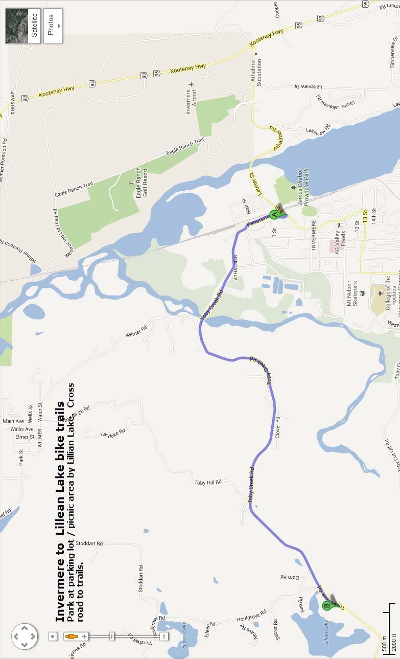
2

 with natural technical features. Highlights: Fantastic views of the Toby Creek and the Rocky Mountains.")
3 IMBA RULES OF THE TRAILS 1. RIDE ON OPEN TRAILS ONLY. 2. LEAVE NO TRACE. 3. CONTROL YOUR BICYCLE! 4. ALWAYS YIELD TRAIL. 5. NEVER SCARE ANIMALS. 6. PLAN AHEAD. For More Info See: How To Get There? Along The Johnson Bike Trails Lake Lillian Toby Creek Road Kilometers Toby Creek Along The Johnson - Singletrack Description: Epic XC trail with fast and flowy sections, good climbs, and technical descents. Approximate ride time: 1.5 hours. Length: 11 kilometres. Difficulty: Intermediate (blue) with natural technical features. Highlights: Fantastic views of the Toby Creek and the Rocky Mountains. Suggestion: Use caution, especially on exposed section along the Toby Canyon. Along The Johnson - Green Trail Description: Doubletrack and old dirt road linked together to offer a fun loop with some mild change of elevation. Great to do with the whole family. Approximate ride time: 45 minutes. Length: 2.5 kilometres Difficulty: Beginner (green). Suggestion: Great to do with a Charriot. Legend Beginner Trail Intermediate Trail Advanced Trail Parking Viewpoint Bridge Road (Gravel) Road (Paved) Panorama


4 Mount Swansea Biking & Hiking Trails Description: The mountain features seven downhill trails, most with a black diamond difficulty rating. Difficulty: Plenty of great challenges which include: steep descents, a large step-up jump, rocky and sandy slopes, jumps, and fast, flowy trails. Suggestion: For an extra challenge, check out the hike-abike from the top parking to get to Dirty Monkey. If you prefer to pedal, a hard effort will get you can get to the summit in an hour. Body armour is recommended on all trails. Hikes: the 4.5 Kilometre Swansea Loop Hiking Trail will get you to some great view points. Or try the 15 minute hike from the top parking lot to the mountain summit for a spectacular 360 degree view of the valley. 2 Legend 1 Trails Dirty Monkey Parking Viewpoint Booty Call Road (Gravel) 3 4 Steeps Hula Girl Road (Paved) Hiking Trails 5 5 Autobahn 6 Gravy Train 7 Meat Grinder IMBA RULES OF THE TRAILS 1. RIDE ON OPEN TRAILS ONLY. 2. LEAVE NO TRACE. 3. CONTROL YOUR BICYCLE! 4. ALWAYS YIELD TRAIL NEVER SCARE ANIMALS. 6. PLAN AHEAD. For More Info See: Wi ndermere Loop R oad How To Get There? Kilometers

5 Spirit Trail Columbia Lake Opinion: The beginning of the trail is a nice leisurely one, turning from road/wagon trail to single track. However, the single track is not that long, and when it ends its back to a double track / wagon road / dirt road. While the terrain is very pretty (meadows, etc.) its not a particularly inspiring ride, especially because the lake is out of view most of the time. And it can be quite hot on it. So, do it if you are looking to break up your drive, but I would not go out of my way for it. Fact. To get there from Highway 93/95, turn east onto Fairmont Creek Road and pass the fire hall in Fairmont Hot Springs. Take your first right onto Columbia River Road and drive to the end of the road. In Canal Flats, head north on Grainger Road to Canal Flats Provincial Park. Be sure to swing by the deli at the Family Foods store on Arbuckle to pick up a couple of Canal Flats Club sandwiches (also known as a Stansbury Special or Palliser Pizza ), consisting of a pepperoni stick baked inside a wad of cheese dough. Mmmm. The Spirit Trail : Fairmont to Canal Flats The Spirit Trail is a traditional trail on the east side of Columbia Lake between Fairmont and Canal Flats. It s been there a very long time, and there are a few things you should know before you decide to ride, hike or trail-run in this very beautiful area. 1) The parcel of once-private land (lot 48), was purchased by the Nature Conservancy of Canada in Great news! 2) If you come across cattle or horses, dismount your bike and walk. 3) Although not in any reserve, this land south of lot 48 is traditional land of First Nations. Please respect that. 4) Access at each end is marked by the BC Ministry of Environment as for non-motorized use only. For good reasons! The trail as shown is 12.5 km long, the northern end being nice very single-track. (some is quite new) The southern half is doubletrack. It s all nice riding. The total distance from the Canal Flats town office to the Fairmont Coffee-shop, via this trail, is 25.5 km. Trailhead North : Trailhead South :
Calaveras Big Trees State Park--South Grove Loop
 Copyright 1999 by Jeff Robinson. You are free to use and reproduce this description for personal, not-for-profit, and not-forbusiness use. Any reproduction other than for personal use, including businesses,
THE FIRST MOUNTAIN BIKE TRAIL CENTRE IN THE GCC & MIDDLE EAST
 THE FIRST MOUNTAIN BIKE TRAIL CENTRE IN THE GCC & MIDDLE EAST INTRODUCTION WELCOME TO HATTA TRAIL CENTRE WEBSITE Hatta Trail Centre is a first MTB Centre in the Middle East, and is a home to multiple cross
Fish Lake Team Relay Course Information 2016
 Fish Lake Team Relay Course Information 2016 Fish Lake Team Relay Course Information 2016 The Fish Lake Team Relay begins at Fish Lake Lodge on the shores of beautiful Fish Lake located in Sevier County,
Fish Lake Team Relay Course Information
 Fish Lake Team Relay Course Information Fish Lake Team Relay Course Information The Fish Lake Team Relay begins at Fish Lake Lodge on the shores of beautiful Fish Lake located in Sevier County, Utah. The
LAKE TAHOE peopleforbikes.org/e-bikes
 emtb ADVENTURE MAPS LAKE TAHOE peopleforbikes.org/e-bikes OVERVIEW Lake Tahoe is an iconic destination for mountain biking. With crystal blue waters surrounded by mountain peaks on all sides, the area
2017 Racer Manual Desert RATS mtb Classic
 2017 Racer Manual Desert RATS mtb Classic May 13, 2017 Fruita, CO Hello Racers and Crews! We can t wait to see all of you this May - hopefully with fresh legs and a powerful spirit, ready to start the
Trail Notes Local Mountain Bike Areas
 Trail Notes Local Mountain Bike Areas Campus Recreation 875 Perimeter Drive MS 1230 Moscow. Idaho 83844-1230 Ph: 208.885.6810 Rentals: 208.885.6170 Fax: 208.885.6879 uidaho.edu/outdoorprogram 1 Table of
9. APPENDICES Disciplines of Mountain Biking
 9. APPENDICES 9.1. Disciplines of Mountain Biking Cross-country Cross-country mountain biking is the oldest discipline within the sport and is analogous to cross-country running or skiing. It involves
Gravel Bike Guide Haywood County
 Gravel Bike Guide Haywood County Haywood County is an ideal place for bicycling on gravel roads, because 37% or 129,994 acres of Haywood County is federal property, including portions of the Pisgah National
PARADISE VALLEY TRAIL GUIDE
 PARADISE VALLEY TRAIL GUIDE 4949 East Lincoln Drive Paradise Valley, AZ 85253 (480) 627-3200 omnihotels.com/montelucia omnihotels.com/montelucia HIKE, RUN & RIDE IN PARADISE VALLEY The beautiful weather
Explore the outdoors in Shelby County
 Explore the outdoors in Shelby County Oak Mountain Trail GPS: 33.283831-86.865238 Trail Location: Address: Oak Mountain State Park Trail 200 Terrace Drive Pelham, AL 35124 Type of Trail: Walking, Mountain
PARTICIPANT GUIDE 2018 TO THE 25 th ANNUAL EVENT!
 PARTICIPANT GUIDE 2018 TO THE 25 th ANNUAL EVENT! GETTING HERE Find US-41 and head north. Yup, just head north. US-41 ends/begins in Copper Harbor. The main trailhead is right in the middle of town next
Douglas A. Ormseth Shortgrass Web Development
 Douglas A. Ormseth Shortgrass Web Development doug@shortgrass.com 406-261-1115 (Note: others have proposed some of these ideas already in the Black Eagle Community Visioning document and on the Rivers
Williams Lake WestSyde Trail Network
 Williams Lake WestSyde Trail Network This is an intermediate to advanced network with many beginner options. The Westside network has 40 trails with over 97Km of singletrack, including the legendary Box
Mountainbike tour to the Hundstein
 Mountainbike tour to the Hundstein Long climb, steep spots, but amazing views & panoramas A tour for mountainbike experts. Very long, steep - only riders who are in really good shape will have lots of
Minong Area Ski Trails
 Minong Area Ski Trails 7. Beaver Brook Ski Trail Spooner College Street Park Spooner 14. Douglas County Ski Trails Solon Springs 18. Hatchery Park Trail Hayward Hayward Golf Course Hayward 20. Heartwood
Trail and Driving Directions
 Trail and Driving Directions GETTING TO THE START: FROM CADILLAC: Follow M-55 west from US131 for 20.9 miles to the corner of M-37 and M-55 FROM THE INTERSECTION OF M-55 AND M-37: Head west on M-55 2.7
Roads Main trails on this map include; to download this map or Map 1 and track notes
 Derby & Blue Tier Tier Mountain Mountain Bike Trails Trails, ails, Bush Tracks & Access Roads Roads Main trails on this map include; www.visitbluederby.com.au to download this map or Map 1 and track notes
Welcome Official Categories Everyone and anyone. Minimum of 3 males and 3 females 50% of the team must be employed at the same business/company
 Welcome You won t find another race like the Klondike Trail of 98 International Road Relay. It offers breath-taking scenery, team camaraderie, physical challenge and gracious northern hospitality. This
Leg #1 (GUNLOCK AND LOADED) Miles
 Miles") Leg #1 (GUNLOCK AND LOADED)- 6.07 Miles Difficulty: Easy to Moderate This is a nice leg for those who like running downhill. It s a beautiful run down the Santa Clara River canyon to the point where the
Leg #1 (GUNLOCK AND LOADED)- 6.07 Miles Difficulty: Easy to Moderate This is a nice leg for those who like running downhill. It s a beautiful run down the Santa Clara River canyon to the point where the
Ride Center Evaluation Criteria
 Ride Center Evaluation Criteria Singletrack Trail Mileage Minimum Qualifications Quality Trail Experience Objective Scoring Total Minimum Total Qualification Score Miles Kilometers Score Score Level Score
Approach. Via Stewart Creek Three Sisters
 three sisters The Three Sisters are a signature landmark for the Bow Valley and the town of Canmore. They may even compete with Mount Rundle above Banff as the most photographed and painted mountain scene
Banff-Jasper Relay Course Description March 17, 2005
 Banff-Jasper Relay Course Description March 17, 2005 The course description is general, although the distances are reasonably precise. The object is to give teams a sense of the conditions they will meet
Directions for Day 1: Colwood To Metchosin
 Colwood-Metchosin Page 1 of 8 Directions for Day 1: Colwood To Metchosin Start: Royal Roads University, Birds of a Feather B&B, or at Esquimalt Lagoon Finish: Your accommodation in Metchosin Time: 4-5
2015 Brown County Epic Mountain Bike Festival General Information
 2015 Brown County Epic Mountain Bike Festival General Information Brown County Epic Registration Information * Changes in 2015 Epic Rides will take place on Saturday! Demos on Saturday and Sunday Registration
2016 Mountain Bike Races and Festivals in Nova Scotia
 2016 Mountain Bike Races and Festivals in Nova Scotia XC - DH - Enduro - 4X - Endurance From cross country to downhill, four cross to enduro, TrailFlow has the races you re looking for. For 2016 TrailFlow
COURSE GUIDE mozart 100
 COURSE GUIDE mozart 100 mozart Ultra 1), mozart Marathon 2), mozart Light 3), mozart Half Marathon 4) mozart 100, mozart Ultra and mozart Marathon start in the heart of the historical center of Salzburg,
To Benefit the Wachusett Mountain Race Team!
 To Benefit the Wachusett Mountain Race Team! Handbook Outline: Race Overview & Events Schedule....3 Leg 1: 5-mile Run... 4 Leg 2: Scenic Bike Race.....5 Leg 3: Summit Climb......6 Leg 4: Ski Run...7 Application.....8
Pah Rah Mountain Range
 Pah Rah Mountain Range The Pah Rah Mountain Range is located east of the city of Sparks, and parallels Vista Boulevard. The mountain range originates at Interstate 80, and terminates at Pyramid Lake. Most
Course maps for Borlänge Tour, 1 3 June 2018
 Course maps for Borlänge Tour, 1 3 June 2018 The stage race Borlänge Tour has been a part of the Swedish MTB calendar the last eighteen years and has a reputation of being one of the most well organized
USA Cycling Mountain Bike Cross-country Marathon National Championships
 USA Cycling Mountain Bike Cross-country Marathon National Championships Tech Guide Columbia County, Georgia June 4, Held in conjunction with the Wildwood Games Rev. 6/2/16 Welcome to the USA Cycling Mountain
Wentworth Falls Conservation Hut Loop
 Wentworth Falls Conservation Hut Loop 3 hrs Hard track 6.7 km Circuit 4 341m This scenic walk from Wentworth Falls Station, winds along the Nature Trail to Conservation Hut, then drops into the magnificent
Welcome, Wilmington Whiteface Athletes
 Welcome, Wilmington Whiteface Athletes Congratulations, you picked an amazing East Coast qualifier! Youphoria Productions proudly presents the 2017 Blueprint for Athletes Wilmington Whiteface MTB. Where
Mountain Biking Comes to Town
 Mountain Biking Comes to Town Mountain Biking Old School Mountain Biking New School Agenda 1. Introductions 2. What is a bike park? 3. Who wants a bike park? 4. Why should you build it? 5. Where can you
Cross Country Skiing in the Tumbler Ridge Area
 Cross Country Skiing in the Tumbler Ridge Area There are numerous locations that are great for cross country skiing in the area surrounding Tumbler Ridge. Some are on trails that have hiking brochures
Dan Andrews. Expert Advisor to the Ontario Ministry of Tourism, Culture & Sport OPA Ed Conference, Burlington, ON March 1, 2018
 Dan Andrews Expert Advisor to the Ontario Ministry of Tourism, Culture & Sport OPA Ed Conference, Burlington, ON March 1, 2018 I Will Share With You Typical New User Experience Leading Towards Classification:
COMPETITOR INFO PACK. Page 1
 2016 COMPETITOR INFO PACK Page 1 3 Page 2 75k 50k 25k Race start time 75km Competitors & Teams Race Start: 8am Briefing: 7:45am 50km Competitors Race Start: 9am Briefing: 8:45am 25km Competitors Race Start:
Welcome to the 3 day Leadville Stage Race!
 Welcome to the 3 day Leadville Stage Race! This Year marks the 23rd anniversary of the first Leadville Trail 100 mountain bike race. We are excited to have you join us for the second year of this challenge.
COURSE GUIDE mozart 100 mozart Ultra 1), mozart Marathon 2), mozart Light 3), mozart Half Marathon 4)
, mozart Marathon 2), mozart Light 3), mozart Half Marathon 4)") COURSE GUIDE mozart 100 mozart Ultra 1), mozart Marathon 2), mozart Light 3), mozart Half Marathon 4) mozart 100 and mozart Ultra start in the heart of the historical center of Salzburg, on the Kapitelplatz
COURSE GUIDE mozart 100 mozart Ultra 1), mozart Marathon 2), mozart Light 3), mozart Half Marathon 4) mozart 100 and mozart Ultra start in the heart of the historical center of Salzburg, on the Kapitelplatz
PROGRAM ENDURO TOUR SARDINIA 2018
 ENDURO TOUR SARDINIA 2018 PROGRAM ENDURO TOUR SARDINIA 2018 On this especially unique island of Sardinia you will experience maybe one of the most exciting enduro rides ever. With meandering curves, passes
CYCLING. Scoutmaster Bucky. Merit Badge Workbook EXPLAIN TO YOUR COUNSELOR THE MOST LIKELY HAZARDS YOU MAY ENCOUNTER WORKBOOK INFORMATION
 SCOUT S INFORMATION MERIT BADGE COUNSELOR INFORMATION Name Name Phone Address Organization City State Zip WORKBOOK INFORMATION Scoutmaster Bucky Workbook based off of Boy Scout Requirements 2018 Edition
ACTIVE CHOICES Exercise Locations in BC
 ACTIVE CHOICES Exercise Locations in BC No Name of Organization Phone Number 1 Abbotsford Recreation Centre 604-852-4221 Several centres so pick up an activity guide 2 North Vancouver Community Centres
Queen Creek Canyon. Guidebooks The Rock Jocks Guide to Queens Creek Canyon by Marty Karabin Jr.
 is one of Arizona s best winter climbing destination. The area is about 1 1/2 hours east of hoenix and elevation is around 4000 feet. The rock is a thick formation of ash that was deposited between 15
Pump N Pedals FN Epic Event Schedule 2017
 Pump N Pedals FN Epic Event Schedule 2017 Friday 12 May 4:30pm 5:30pm o 1 st Race pack collection opportunity Pump N Pedals 113-117 Sheridan Street, Cairns Saturday 13 May 3:00pm 4:00pm o 2 nd Race pack
Trail Objec ves. Eleva on Profile. Trail Alignment. Warburton Mountain Bike Trails Design & Masterplan. Trail ID Status Length Difficulty Style
 13A Proposed 2.95 km Advanced Cross country 400m 246m Connec vity Exercise Hey Hey My My is 3,000m of old-school technical Cross-Country/ All Mountain trail. Built by hand on the western slopes of Minesha
OUTDOOR ENCOUNTER PROJECT BRIEF WILKINS BRANCH MOUNTAIN BIKE PARK LEIPERS FORK, TN PREPARED FOR OUTDOOR ENCOUNTER BY
 OUTDOOR ENCOUNTER PROJECT BRIEF WILKINS BRANCH MOUNTAIN BIKE PARK LEIPERS FORK, TN PREPARED FOR OUTDOOR ENCOUNTER BY WILKINS BRANCH BIKE PARK BRIEF LEIPERS FORK, TN TABLE OF CONTENTS DEFINITIONS WHAT IS
The Little Club that Could
 The Little Club that Could The Revelstoke Nordic Ski Club can trace its roots back to 1891. The Revelstoke Ski Club is Canada s second oldest ski club. The Club represented all disciplines of skiing including
OPSF Participant Guide 2019
 OPSF Participant Guide 2019 TABLE OF CONTENTS Welcome Organization History Location Schedule of Events Friday, March 22, 2019 Saturday, March 23, 2019 Race Rules Parking Race Information Start Times Distances
2017 Big Woods Brown County Epic Mountain Bike Festival General Information
 2017 Big Woods Brown County Epic Mountain Bike Festival General Information Brown County Epic Registration Information Registration Includes: Free commemorative t-shirt Epic rides of up to 100 miles with
Gran Canaria road cycling Tour 2019
 Gran Canaria road cycling Tour 2019 Gran Canaria road cycling Tour 2019 Guided Gran Canaria road cycling Tour 2019. From October until April Check all cycling tours in Spain here: ALL CYCLING TOURS IN
ELK VALLEY ULTRA RACER HANDBOOK PRESENTED BY STAG LEAP RUNNING CO. JULY 29, 2017 FERNIE, BC
 ELK VALLEY ULTRA RACER HANDBOOK JULY 29, 2017 FERNIE, BC PRESENTED BY STAG LEAP RUNNING CO. TABLE OF CONTENTS WELCOME PAGE 3 GETTING READY PAGES 3 4 o Accommodation Discounts o Can t Race? o Change to
Eligibility: You must have completed at least one 100 Mile TRAIL RUN or a qualifying 50 Miler (see website for 50 mile qualifying events).
.") Cruel Jewel 100 Mile Course Description The Cruel Jewel 100 is a 108 mile foot race deep with in the beautiful Chattahoochee National Forest of the North Georgia Mountains. It consists of 95 miles of trails,
Cruel Jewel 100 Mile Course Description The Cruel Jewel 100 is a 108 mile foot race deep with in the beautiful Chattahoochee National Forest of the North Georgia Mountains. It consists of 95 miles of trails,
GCSE 4171/01 ENGLISH/ENGLISH LANGUAGE FOUNDATION TIER UNIT 1 (READING)
") GCSE 4171/01 ENGLISH/ENGLISH LANGUAGE FOUNDATION TIER UNIT 1 (READING) A.M. TUESDAY, 7 June 2016 1 hour S16-4171-01 ADDITIONAL MATERIALS Resource Material. You will need a WJEC pink answer booklet, which
GCSE 4171/01 ENGLISH/ENGLISH LANGUAGE FOUNDATION TIER UNIT 1 (READING) A.M. TUESDAY, 7 June 2016 1 hour S16-4171-01 ADDITIONAL MATERIALS Resource Material. You will need a WJEC pink answer booklet, which
Wallarah Coastal Walk
 Wallarah Coastal Walk 3 hrs 8.3 km Return Hard track 247m This walk starts at Caves Beach and travels south along the coastline, until reaching the Pinney s Headland Lookout. There are many opportunities
RACE BOOK 2018 California Enduro Series Mammoth Bar Enduro Auburn, CA June 16, 2018
 RACE BOOK 2018 California Enduro Series Mammoth Bar Enduro Auburn, CA June 16, 2018 Location Registration Categories Mammoth Bar OHV, Auburn SRA, Auburn, CA Old Foresthill Road - Auburn, CA 95603 Registration/Packet
2016 North Country Trail Relay Updated Event Instructions Jan 2016
 Welcome to the 2016 North Country Trail Relay (NCTR). organized by Bev Chesebro and Doug Bostian The race is run on the North Country National Scenic Trail, which is a footpath that one day will stretch
MOAB 2014 Ride Camp Featuring Trek Dirt Series Coaches Oct. 8
 MOAB 2014 Ride Camp Featuring Trek Dirt Series Coaches Oct. 8 Our Mountain Bike Ride Camps are unlike any other Trek Travel bike trip. They are designed specifically to get you out on Moab s world-renowned
Bikeability Checklist
 Bikeability Checklist How bikeable is your community? Riding a bike is fun! Bicycling is a great way to get around and to get your daily dose of physical activity. It's good for the environment, and it
Right to roam and/or purpose build mountain bike trails?
 Right to roam and/or purpose build mountain bike trails? Best of both worlds or conflicting interest? Heiko Mittelstädt / DIMB Trail Network in Germany Historic trail network is very dense: Gravelled forest/fire
LOCATION Machico, Madeira Island, Portugal REGISTRATION CATEGORIES PROTECTION RULES. Document created by MADproductions
 LOCATION Machico, Madeira Island, Portugal REGISTRATION CATEGORIES PROTECTION RULES COURSE DESCRIPTION By António Abreu, MADproductions LINK 1 (4,96km - 208hmm uphill - 11hm downhill) Start the race at
ALL THE WAY: A VALLEY FOR BIKERS
 ÖTZTAL ON BIKE As an Ötztaler you do, of course, know that the world gets more and more beautiful the higher you get. That s why we not only spend our maximum of time outside, but also on the way up all
Event History: Kevin Tilton Steve Peterson Paul Young
 Event History: Northfield enters its fifth year as part of the Western Mass. Athletic Club (WMAC) snowshoe series. Northfield has served as a regional qualifier for the USSSA national championship and
ABOUT LOCATION THE RACE RACEBOOK 2017
 RACEBOOK 2017 ABOUT LOCATION Prazeres Calheta, Madeira Island The mountains above the village of Calheta hide a secular heritage that the strength of Man and Nature carved. The trail system that is now
I-5 Colonnade Mountain Bike Skills Park. Phase 2. High Level Design & Trail Standards
 I-5 Colonnade Mountain Bike Skills Park Phase 2 High Level Design & Trail Standards Table of Contents OVERVIEW... 3 INTRODUCTION...3 ACKNOWLEDGEMENTS... 3 PURPOSE AND SCOPE... 4 DESIGN FLEXIBILITY... 4
2016 Brown County Epic Mountain Bike Festival General Information
 2016 Brown County Epic Mountain Bike Festival General Information Brown County Epic Registration Information *2016 Epic Rides will take place on Saturday again this year. Event camping offered Thursday
HURL ELKHORN 50K RUN AID STATIONS COURSE MARKINGS
 HURL ELKHORN 50K RUN AID STATIONS The race starts and finishes at Crystal Creek Campground, where primitive camping is available. The race starts at 7:00 am. The finish cut off time is 9:00 pm. No drop
REGIONAL MUNICIPALITY OF WOOD BUFFALO BIKE PARK OPEN HOUSE. RMWB BIKE PARK IBI Group NOVEMBER 7, 2013
 REGIONAL MUNICIPALITY OF WOOD BUFFALO BIKE PARK OPEN HOUSE SITE CONTEXT SITE 1 NORTH PARSONS CREEK LANDS SITE 2 SILIN FOREST ROAD SITE 3 LOWER WOLVERINE SITE 4 REAL MARTIN DRIVE PARSONS CREEK TIMBERLEA
Blue Mountain 200K November 10, 2018 Time Limit 13:30 hours
 Blue Mountain 200K November 10, 2018 Time Limit 13:30 hours Andrew's Cell phone: (717) 203-1471 Bill Olsen's Cell phone: (908) 268-9690 L=Left, R=Right, T=T Intersection, B=Bear, X=Cross TRO=To remain
distance Easy/Moderate
 Experience Rating Easy/Moderate distance 40km (25m) Cycling route: 40km (25 miles) Cycling in: The Great Waterway, Prince Edward County Number of days cycling: 1 Recommended number of nights stay: 2 Experience
Yosemite: The Complete Guide: Yosemite National Park (Yosemite The Complete Guide To Yosemite National Park) By James Kaiser READ ONLINE
 By James Kaiser READ ONLINE") Yosemite: The Complete Guide: Yosemite National Park (Yosemite The Complete Guide To Yosemite National Park) By James Kaiser READ ONLINE Lodging in Yosemite National Park: Yosemite has 7 lodging facilities,
Yosemite: The Complete Guide: Yosemite National Park (Yosemite The Complete Guide To Yosemite National Park) By James Kaiser READ ONLINE Lodging in Yosemite National Park: Yosemite has 7 lodging facilities,
Timing: 2 days Grade: AD- / Moderate snow slopes some steep climbing - Beginner suitable
 PERUVIAN ANDES ADVENTURES CLIMB VALLUNARAJU 5686m (18655 ft) Timing: 2 days Grade: AD- / Moderate snow slopes some steep climbing - Beginner suitable Eli & Rolando Morales & the Peruvian Andes Dog (Cholo)
4171/01 ENGLISH/ENGLISH LANGUAGE FOUNDATION TIER UNIT 1 (READING) A.M. TUESDAY, 7 June hour plus your additional time allowance
 A.M. TUESDAY, 7 June hour plus your additional time allowance") GCSE 4171/01 ENGLISH/ENGLISH LANGUAGE FOUNDATION TIER UNIT 1 (READING) A.M. TUESDAY, 7 June 2016 1 hour plus your additional time allowance WJEC CBAC Ltd. JD*(S16-4171-01) MLP36 2 ADDITIONAL MATERIALS
GCSE 4171/01 ENGLISH/ENGLISH LANGUAGE FOUNDATION TIER UNIT 1 (READING) A.M. TUESDAY, 7 June 2016 1 hour plus your additional time allowance WJEC CBAC Ltd. JD*(S16-4171-01) MLP36 2 ADDITIONAL MATERIALS
10 TO 4 WITH GOWILD AFRICA
 Day 1 12th Feb 2015 Arrive by road to Olepangi Farm, driving through the beautiful Kikuyu Highlands, arriving in time for a hearty lunch. This is a drive of approximately 4 hours. Spend the afternoon as
Biketours in Leogang
 Easy Mountainbike Tours Biketours in Leogang Kronteith-Ramseiden Runde Distance: 18,2 km Time: 2 Std. From the centre of Saalfelden the route leads eastwards to Ramseiden. Passing the Theurerhof, the trail
HUNTSMAN WORLD SENIORGAMES MOUNTAIN BIKING OCTOBER15-16,2018 H U N T S M A N W O R L D S E N IO R G A M E S. #worldseniorgames
 MOUNTAIN BIKINGBIBLE OCTOBER 15-16,2018 - ST.GEORGE,UTAH - USA H U N T S M A N W O R L D S E N IO R G A M E S CHALLENGE YOURSELF.CHALLENGE THE WORLD HUNTSMAN WORLD SENIORGAMES MOUNTAIN BIKING OCTOBER15-16,2018
La Madre Wilderness Area
 La Madre Wilderness Area Rock Climbing Inventory Statistics: Area: Walls La Madre North 3 24 136 22 Kraft Mt./Gateway Canyon White Rock Springs Willow Springs East The Promised Land 18 4 3 3 12 23 11 24
GCSE 4171/01 ENGLISH/ENGLISH LANGUAGE FOUNDATION TIER UNIT 1 (READING)
") GCSE 4171/01 ENGLISH/ENGLISH LANGUAGE FOUNDATION TIER UNIT 1 (READING) A.M. TUESDAY, 7 June 2016 1 hour S16-4171-01 ADDITIONAL MATERIALS Resource Material. You will need a WJEC pink answer booklet, which
GCSE 4171/01 ENGLISH/ENGLISH LANGUAGE FOUNDATION TIER UNIT 1 (READING) A.M. TUESDAY, 7 June 2016 1 hour S16-4171-01 ADDITIONAL MATERIALS Resource Material. You will need a WJEC pink answer booklet, which
ROAD TRIP! An Opinionated Guide to Groomed Nordic Skiing Destinations in the Northwest. John Sarich - December 2018
 ROAD TRIP! An Opinionated Guide to Groomed Nordic Skiing Destinations in the Northwest John Sarich - December 2018 What we are going to talk about... 31 good or great places you can drive to in a day 4
Rodopi mountain bike adventure (Bulgaria)
") Rodopi mountain bike adventure (Bulgaria) Real mountain bike adventure in the heart of the Rodopi mountains. This is a unique bike tour covering a great part of The Western and Middle parts of the mystic
Rodopi mountain bike adventure (Bulgaria) Real mountain bike adventure in the heart of the Rodopi mountains. This is a unique bike tour covering a great part of The Western and Middle parts of the mystic
Caerlee: Average Age = 6 (June 2017)
") Caerlee: Average Age = 6 (June 2017) Safety Able to follow M Check Take part in 10 minute blocks of cycling or coaching. Equity/ Social Able to interact and share with peers. Plays by the rules. Confident
Caerlee: Average Age = 6 (June 2017) Safety Able to follow M Check Take part in 10 minute blocks of cycling or coaching. Equity/ Social Able to interact and share with peers. Plays by the rules. Confident
TRAINING RECOMMENDATION
 TRAINING RECOMMENDATION If you have entered the Tour de Zambezi, and have not ridden a multi-stage mountain bike event before, please do not under estimate the amount of training required prior to the
A Guide to Unicorn Canyon Peter Nelson, Craig Doram Zak McGurk cruising the second ascent of Money Jane
 A Guide to Unicorn Canyon Peter Nelson, Craig Doram Zak McGurk cruising the second ascent of Money Jane P a g e 2 Table of Contents Introduction... 2 Getting There... 2 Climbing Area Descriptions... 5
Operational Policy. Queensland Parks and Wildlife Service. Mountain biking in QPWS managed areas. Visitor Management. 1 Purpose
 Queensland Parks and Wildlife Service Operational Policy Visitor Management Mountain biking in QPWS managed areas Operational policies provide a policy direction or set operational standards for day-to-day
USA Cycling Mountain Bike Cross-country Marathon National Championships
 USA Cycling Mountain Bike Cross-country Marathon National Championships Tech Guide Columbia County, Georgia May 2, Held in conjunction with the Wildwood Games Welcome to the USA Cycling Mountain Bike Marathon
Day 1 (Farley 7745, Bow Knot, Toxaway 8323)
") Date August 8 12, 2005 Time Location Sawtooths (Tin Cup Trailhead) Weather Scattered Clouds Fish Species Rainbow, Brook, Cutthroat Size Range Brook 6-11 Rainbow/Cutthroat 12-18 Fish Caught To many to count
Date August 8 12, 2005 Time Location Sawtooths (Tin Cup Trailhead) Weather Scattered Clouds Fish Species Rainbow, Brook, Cutthroat Size Range Brook 6-11 Rainbow/Cutthroat 12-18 Fish Caught To many to count
LET S get moving! campus walking routes. ulethbridge.ca/hr/wellness. University of Lethbridge 4401 University Dr. West Lethbridge, AB T1K 3M4
 LET S get moving! campus walking routes University of Lethbridge 4401 University Dr. West Lethbridge, AB T1K 3M4 ulethbridge.ca/hr/wellness Living Well at the U of L This walking guide is a result of feedback
Illustrated Directions to Nitinat Lake: Prepared by mike blades on August 4, 2005
 Illustrated Directions to Nitinat Lake: Prepared by mike blades (Mike_Blades@shaw.ca) on August 4, 2005 1 Take the Island highway #1 to Duncan from Victoria OR Nanaimo. Just north of Duncan, take highway
2015 Hertfordshire Triathlon Summer Sunday 30 th August
 Dear Race Entrant, Race Details This is your race information pack for the Hertfordshire Triathlon Summer and the Hetfordshire Triathlon Club Champs. ActiveTrainingWorld would like to thank Triathlon Zone,
Ski Ranonnee: Backcountry Skiing For The Alpine Skier
 Ski Ranonnee: Backcountry Skiing For The Alpine Skier If you are looking for the ebook Ski Ranonnee: Backcountry Skiing for the Alpine Skier in pdf format, then you've come to the loyal site. We furnish
2016 Hertfordshire Triathlon Spring Sunday 28 th August
 Dear Race Entrant, Race Details This is your race information pack for the Hertfordshire Triathlon Spring and the Hertfordshire Triathlon Club Champs. ActiveTrainingWorld would like to thank Moveology,
Kathmandu, Nepal May 2012 Everest Marathon Leaves Runners Gasping for Breath
 In News Focus #7, we visit Nepal, the landlocked country in the Himalayas. The mountainous north of Nepal contains 240 peaks over 6,000 meters in height. Eight of the world s tallest mountains are found
Classic cross country skiing 101
 Classic cross country skiing 101 Created by Lisa Wickerson for Trakkers Ski Club 2017 Contents Trail code Trail markers Putting on your skis Fitting and putting on ski poles Ski techniques Diagonal stride
Govetts Leap Loop. 1065m. 909m Blue Mountains National Park. 4 hrs 30 mins 8.7 km Circuit. Hard track 380m
 Govetts Leap Loop 4 hrs 30 mins 8.7 km Circuit Hard track 380m This walk, from Blackheath Train Station, is a fantastic way to see some of the iconic areas of the Blue Mountains in the Blackheath area.
Commitment like this is hard to find. Thank you for riding with us in Leadville!
 Welcome to the 3 day Leadville Stage Race! This Year marks the 23rd anniversary of the first Leadville Trail 100 mountain bike race. We are excited to have you join us for the second year of this challenge.
XC Eliminator Rules, Regs & Info
 XC Eliminator Rules, Regs & Info Race Format The XC Eliminator is a race tournament where four riders race side by side on a short cross-country mountain bike course. Each race consists of a single lap
201 7 R U N N E R S G U I D E
 201 7 R U N N E R S G U I D E Welcome to the 2017 Butch Cassidy 10K and 5K. We are happy you have joined us for this year s race. Please review the important information in this runners guide. If you have
The short tour. Lahn: short TOUR DESCRIPTION
 Lahn: short TOUR DESCRIPTION The short tour A little more than a weekend - but really a lot of holiday. On this cycling tour, you start in the lively university town of Marburg, famous for the Elisabethkirche
PHOTO: ERIC MICKELSON 2018 ANNUAL REPORT
 PHOTO: ERIC MICKELSON 2018 ANNUAL REPORT TRAIL BUILDING & ADVOCACY HIGHLIGHTS Galbraith Access Preserved Forever! Recreation and Conservation Easements secured by the City of Bellingham, Whatcom Land Trust
Assessed Acres 30,913 2,920 (2,040 State and 880 Private) Free Use 320 Total Ranch Acres 34,153 (All acreages are approximate)
 Free Use 320 Total Ranch Acres 34,153 (All acreages are approximate)") CADDOA CREEK RANCH 30,913 DEEDED ACRES BENT COUNTY, COLORADO We are excited to offer the Caddoa Creek Ranch for sale. Our belief is that this ranch offers a variety of management options. The ranch has
CADDOA CREEK RANCH 30,913 DEEDED ACRES BENT COUNTY, COLORADO We are excited to offer the Caddoa Creek Ranch for sale. Our belief is that this ranch offers a variety of management options. The ranch has
GORGE GRAVEL GRINDER 9:00 am - April 7 th The Dalles, Oregon
 GORGE GRAVEL GRINDER 9:00 am - April 7 th The Dalles, Oregon Introduction The Gorge Gravel Grinder is where it all started. Located in The Dalles this eastern Oregon location is the best known for its