Roads Main trails on this map include; to download this map or Map 1 and track notes
|
|
|
- Sharyl Blake
- 5 years ago
- Views:
Transcription


")


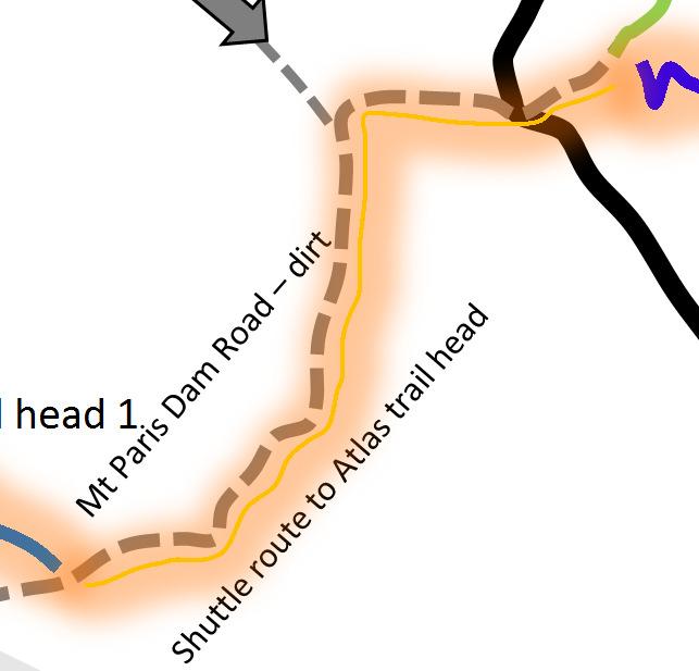
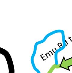
1 Derby & Blue Tier Tier Mountain Mountain Bike Trails Trails, ails, Bush Tracks & Access Roads Roads Main trails on this map include; to download this map or Map 1 and track notes New single track all intermediate rated 40 km Blue Derby Epic Trail Blue Tier > Weldborough 18 km (includes Big Chook) Weldborough > Atlas trail head 6 km Atlas > Dam Busters 8 km Dam Busters > Devilwolf 2 km Devilwolf > Derby 2 km Or Devilwolf > Long Shadows > Return to Sender Tasman Highway Atlas Big Chook Loop (Can ride up Emu Rd (dirt) from Weldborough 4 km and 5 km down Big Chook! Little Chook loop Moorina Map 2 of 2 Ringarooma River Track Derby stacked loop trails - See Map 1 Cemetery Golf club Old School Trails all intermediate rated and include; Blue Tier Descent (about 10 km, depending on start route) OC Track - 8 km Mutual Road Descent 7 km to Mutual Rd and another 8 km to Derby (starting at Atlas trail head) Best of both worlds Ride the first 6.4 km of the new Blue Tier trail (from under the timber gateway) and exit over the back of the left hand berm. A 20 metre hike a bike gets you on the old school Blue Tier Descent (turn left onto trail). Rocks slabs, bouldering, river crossing follow then onto the 4wd track and finish with a full Big Chook. Can life get any better than this? Derby Start of OC track multi purpose Krushka s Branxholm 6.4 km from start of new Blue Tier gateway you can jump onto the best section of old school Blue Tier Descent shuttle point to trail head Black Stump Follow signs from here to ride up to top of Atlas Blue Tier Trail Blue Tier Trail shuttle point to Atlas Trail Head 1 Weldborough Atlas trail head 1 shuttle point Weldborough & Big Chook or pick up for Atlas and Blue Tier Sign on Mt Paris Dam Rd shuttle point to the 40 Km Blue Derby Epic Trail or TM Blue Tier Descent
2

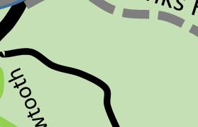
3 Basic Trail Info for Derby & Blue Tier The trails around Derby are a stacked loop design and are ridden in a single direction ONLY. Note direction of arrows. Take plenty of water / food with you, especially if riding up to Atlas or Dam Busters. Do not drink from creeks! Not toilets on trails either! Mobile Telstra. No other providers have coverage in this valley! For the kids & beginners (green trails) Fitness level required not much 3 trails only sorry! River trail - from the showers (primary trail head) to the secondary trail head and shuttle depart point for Atlas. Chain Gang This trail is wheel chair friendly and flows around the mining works around the Cascade River s edge. Great easy trail. Rusty Crusty This is a third option but please be careful as there are some rough rocky creek crossings and the odd rough section. Kids / beginners may need to walk these. The rest of the trail rides like Chain Gang and well worth it. This trail is the main trail into the trail network and thus links onto Saw Tooth. Experienced beginner to intermediate riders Axe Head This is the main trail that takes you up to all the other trails in the Derby network. This is a great ride that takes you through along the lower reaches of the Cascade River and through the twisties. Be sure to grab a photo at Trout Falls before heading up to Devil Wolf. Devil Wolf This rocky canyon is a must stop and is reached after crossing a small green bridge and rock pathway. More often than not, you miss this until you ride Long Shadows & Flickity Sticks. Devil Wolf is the centre of most of the trails in this area. From here you can ride; 1. Up Long Shadows & down Flickity Sticks 2. Up Long Shadows, Long Shadows Upper From this you can ride; Return to Sender, Long Shadows Upper & Lower, Shearpin & 23 Stitches, Dentonate or onto Dam Busters or Atlas (via Carnac Rd) 3. Dam Busters (via Long Shadows & 1/3 Flickity Sticks and along The Great Race and up Heart Break Hill) 4. Krushka s 5. Trouty (via Krushka s) 6. Rattler 7. Boulder Falls 8. or back to Derby via Relics & Saw Tooth 9. You can ride up to the Atlas, via Dam Busters (up route), then follow the signs. Long Shadows (5 15 minutes) up Long Shadows is a gentle climbing ride on an easy trail. Basic fitness is required, with basic bike skills. It follows a few water races, which were used to direct water to Derby s tin mines, many years ago, as it winds its way up to Flickity Sticks.
4 Long Shadows Upper (5-15 minutes) up Long Shadows upper takes you to the new shuttle point at the top of Cascade Dam Rd. The trail uses switchbacks to assist in the required elevation gain. A nice ride that requires a bit of effort & fitness. The payoff is worth it, with a choice of 3 trails at the top. Flickity Sticks Upper & Lower, Return to Sender (takes you back to Derby), Shearpin / 23 Stiches or onto Dam Busters / Atlas. Flickity Sticks Upper (3-8 minutes) down This is an awesome extension of Flickity Sticks lower and well worth the extra climbing. With heaps of huge berms, roll overs and features, this light blue trails suits the advance beginner on. Flickity Sticks (5-8 minutes) down Flickity Sticks is a great descending ride, with a selection of berms to get you ready for the other trails in the area. It is the easiest of the blue trails in the network and well worth your effort. Note If you find Flickity Sticks difficult, do not try the others and make your way back to Derby via Relics & Saw Tooth Boulder Falls (5 10 minutes) Easy except for crossing at falls Relics (5 minutes) Easy. Suit experienced beginner Relics is a return trail from the junction at Long Shadows & Flickity Sticks. It basically follows the old road back to where Rattler trails joins Saw Tooth. Saw Tooth (10 20 minutes) Easy. Suit experienced beginner Saw Tooth is the return trail back to Derby from Devil Wolf. It has a few minor technical points along the way, but these can be walked if need be. You can side track to Monument, which needs to be ridden with care, as some sections go past 3 metre drops. The monument gives you a view over the township of Derby. Blue Derby Wilderness Trail (Blue Tier Section) This trail start at the top of the Blue Tier at Piomenia, This trail is a 50 to 90 minutes (18 km) light blue ride with a few technical features. It transverses sub alpine terrain, with great views across north east Tasmania (on a sunny day!) It goes through Myrtle forests and along creels and stream, similar those found in in Cradle Mountain National Park. It has a very gentle sloping gradient, with the odd switchback and creek crossing. The trail builders have gone for back country experience over excitement and adrenaline in this trail. Intermediate Riders Dam Busters (1 2 hours) Good level of bike skills required (for the descent into Devil Wolf fitness and) This ride requires a bit of effort to get to the main trail. From Devil Wolf you head up Long Shadows > then go down 1/3 of Flickity Sticks and turn right onto the Dam Busters Trail. You ll travel up along Heart Break Hill before descending down onto Cascade Dam Rd. You ll then follow this 4wd tack until one again hitting some magic single track. Be sure to look up and around as you ride along this bit of trail. When you hit the old logging bridge with the new bit over the top, stop here for a refueling stop, as the fun now begins or at the lakeside Stop, 5 minutes further on. Dam Busters finishes at Devil Wolf. This is the rock canyon you see in many photos. From here, you can ride Krushka s or Long Shadows > Flickity Sticks or head back to Derby either via right (Boulder Falls) or left & cross over green bridge and head off right down Relics, cross the creek and left into Saw Tooth onto Derby. Ride Option 2 - This is a quicker and easier UP option, or so we believe, as it takes out Heartbreak Hill. Ride up Cascade Dam Rd (which starts of Krushka s St (see Derby Town Hall). A tarmac rd soon turns to dirt and is a steady climb. You ll soon pass a Blue Derby trail signpost, where Long Shadows pops onto the road. Continue up Cascade Dam Rd and head straight ahead when the road goes right. Just after this, you ll see the trail post for Flickity Sticks. Continue up Cascade Dam Rd, as it climbs for another few km. Then it s down to the lake. Turn right head (Dam Busters trail from Heartbreak Hill comes in from the right here. You are now on the old road that will take you to Dam Busters & Atlas trails. Return to Sender (10 20 minutes) along & down, down, down. A great ride back to Derby, following some former mining water races at first. Then you start to descend, passing some great natural features, huge berms and lots of flow. After a bit of climbing, a rest on a bench and lots of ferns, you enter the flow zone, descending into Derby, with 1 metre gap jumps (B lines available) and HUGE berms, you d lose cows in. With a rock slab finish you be spat out in the middle of Derby, opposite the Derby Post Office. Ie. You have just been Returned to Sender! Shearpin (5-10 minutes) down a selection of techy rock slab descents and crossing with a few purpose built timber bridges to help you along. This little warm up gets you ready for 23 Stitches, with a few HUGE berms, 1 metre gap jumps and a nice little techy rock sections to end you up at the bottom of Flickity Sticks. You ll want more after that little effort. Krushka s (45 90 minutes) - Good level of bike skills & fitness required for both the climb up and descent. Intermediate beginner could attempt this, with car & fitness. This is a great ride, especially if you like to put in a bit of effort before your reward. A typical cross country type of ride with descending berms you can lose cows in. It has a few technical sections for the advance beginner, if you have the fitness, both when climbing & descending. It takes through a variety of forest types, so be sure to look around as you ride through. Climb up from Devil Wolf takes between minutes, depending on fitness. Rattler (10 15 minutes) Rattler is normally done as part of Krushka s and requires the same level of skills and fitness.
5 Howler (5 10 minutes) takes you past Boulder Falls. Advanced Beginner could ride this. Just be careful of rock features. You may be best to walk these. Atlas (30-60 minutes one way) - a good level of bike skills is required. Not for beginners! Atlas is a 10km descent (14 km if riding back to Derby), with a few small climbs. You can roll over everything, with B-lines for those that need a safer option. You ll need a few rides to really appreciate the technical aspects of this trail. The trail builders have built a heap of hidden A-line features, for your riding pleasure. If you ride from Devil Wolf up to the top of Atlas & back to Devil Wolf, you ll need to allow 2 hours. The ride up to the Atlas trail head is from the top of Dam Busters. It is well sign posted from this point and is 4.7 km and follows Carnac Rd (forestry road). Mutual Road Descent Suit advanced beginner rider up. This is an old school trail and is 28 km if ridden from Derby, via Dam Busters, up Carnac Rd to the Atlas Trail Head. From here, follow the first section of Atlas and turn right at 3 km (See pink writing on trees (MRD). There is a well-defined old logging trail heading down. 100 metres on, these is a junction to the right. Continue straight on. You are on the descent section. Enjoy. There is some trail marking. Follow MRD signage and pink ribbons/ markings. Weldborough / Blue Tier Little Chook suit beginner Big Chook suit intermediate beginner rider up. Big Chook is the first part of the Blue Tier Trail to open and is accessed from the southern end (ie. Weldborough Hotel). It can be found 4 km from the Weldborough Hotel, down Emu Rd. If heading off from the gate (1 km down Emu Rd) it will be 3 km until you reach the top of the first big climb. The climb requires some fitness but is not too technical. Big Chook itself is an easy ride, with a very smooth and flowy trail with berms you can loose cows in. The trail would suit intermediate beginners on and is a trail that has a lot of small A line jumps. These jumps would appeal to those that are keen to learn how to find some air, but on safe jumps. The land zones are particularly friendly, with smooth wide zones. It goes through a range of environments with again, heaps of ferns enjoy. Note You may like to ride from Derby to ride this section of the Blue Tier trail, a quick drink & lunch at pub and then up Mt Paris Dam Road to the Atlas Trail Head. The quickest way to ride to Weldborough is via Banks Rd, at 2.7 km right onto Mutual Rd (after concrete bridge), turn right at 7. 2 km and up first section of Mutual Road Descent and left up forestry rd. Right at top of forestry rd and left when you hit the Weldborough sign. All up, this is a 14 km ride. (Zero speedo at start of River Track at signage at shower trail head). Alternatively, ride via Atlas ride route, but head right before final pinch and ride towards quarry and then down Mt Paris dam Rd to Weldborough. This is about 19 km. Blue Derby Wilderness Trail (50 90 minutes) This trail would suit an advance beginner upwards. (Blue Tier Section) This trail start at the top of the Blue Tier at Piomenia, This trail is a 50 minute to 90 minutes.. It has a very gentle sloping gradient, with the odd switchback and creek crossing. The trail has three distinct sections. First 1/3 transverses sub alpine terrain, with great views across north east Tasmania (on a sunny day!) It goes through Myrtle forests and along creels and stream, similar those found in in Cradle Mountain National Park. The second 1/3 is a super flowy funfest. Best described as 20 minutes of endless flow. Smile on your dial stuff!. The Final 1/3 is follows the Big Chook trail. Endless berms on this section of track, but be careful, there are a few technical features that can catch you out! Old School Blue Tier Descent ( minutes) This is one of the most organic trails in Australia and is an old logging / mining track. It is multi use, so you ll come across walkers, runners, 4 wheelers, motor bikes and 4wds. They travel in both directions, so please be careful. This trail start at the top of the Blue Tier at Piomenia, the same place as the Blue Derby Trail (follow road signage). It is for advanced intermediate riders who can pick ride lines. Extreme caution when riding when wet as rocks will be very slippery. You can either self-shuttle or grab a commercial one to get yourself to the start at Piomenia or you can ride up Emu Rd (the way you ride up to Big Chook from the Weldborough Hotel) and along to Frome Rd and the old school Blue Tier Descent track. This takes about 90 minutes, if you have average fitness. Remember you are riding up, for at least half of the 12 km ride).
 Shuttle Derby to / from")
6 Shuttle & Ride Suggestions brought to you by Mountainbike Adventures Derby Shuttle & Ride Suggestions - Rides starting from the Blue Tier Reserve Ride 1 - All Day Blue Derby Epic 40+ km (Intermediate and better riding ability and fitness) Shuttle Derby to / from Weldborough to Blue Tier Ride Blue Tier Trail Last 2/3 of Big Chook trail Lunch a Weldborough Hotel Shuttle up Mt Paris Dam Rd to Atlas Trail (or ride the 4 km gravel grind - up) Atlas Trail Dam Busters - final section (plus Black Dragon, if you dare!) Arrive at Devilwolf - had enough? Head directly back to Derby via Howler, Sawtooth, Berms & Ferns Want more? Option A - up Long Shadows and back down Flickity Sticks then onto Howler, Sawtooth, Berms & Ferns to Derby Want more? Option B - up Flickity Sticks and Flickity Stick Upper and pick one of 3 rides from Black Stump. These options are; 1. Ride Full Flickity Sticks, 2. Shearpin & 23 Stitches (black trail) 3. Return to Sender back into Derby (best option) This is backcountry riding, so you need to be self-sufficient. There are no short cuts out, so if you can't fix something, you are pushing your bike all the way to the end of Big Chook. Take the usual spares, chain breaker, links, pump, cable ties, etc Take a drink bottle / Camelback, snacks & $$$ for Weldborough pub. Camera etc Phone reception is virtually non-existent on this trail. You will get reception at the Atlas trail head 1 and some spots on Atlas trail. Ride 2 - World famous All Day Blue Tier Descent 40+ km (Intermediate and better riding ability and fitness) Same as Ride 1 but from the Blue Tier drop off, you follow the Wellington Creek walking track to the Blue Tier Descent This ride is old school riding and requires great bike skills including picking ride lines etc. This ride gives you full Big Chook descent as well. From Weldborough Hotel, same as above. This is backcountry riding, so you need to be self-sufficient. There are no short cuts out, so if you can't fix something, you are pushing your bike to either the forestry road Frome Rd or back to the Weldborough pub. Take the usual spares, chain breaker, links, pump, cable ties, etc Take a drink bottle / Camelback, snacks & $$$ for Weldborough pub. Camera etc Phone reception is virtually non-existent on this trail. You will get reception at the Atlas trail head 1 and some spots on Atlas trail.
7 Shuttle & Ride Suggestions - Rides starting from Weldborough Ride 3 - Big Chook & Atlas trail (Intermediate and better riding ability and fitness) Big Chook is a 8 km up and down loop and Atlas is a 10 km ride down into Devilwolf. Most riders do a number of Big Chook loops leaving from Weldborough before heading back to grab a feed or drink at the Weldborough Hotel, before shuttling or riding up to the Atlas Trail Head (6 km) Shuttle from Derby to Weldborough Ride Big Chook trail (heaps) Pub rehydration / feed Shuttle up Mt Paris Dam Rd to Atlas Trail Head 1 (or ride the 4 km gravel grind - up) Atlas Trail Dam Busters - final section (plus Black Dragon) Arrive at Devilwolf - had enough? Head directly back to Derby via Howler, Sawtooth, Berms & Ferns Want more 1 - up Long Shadows and back down Flickity Sticks then onto Howler, Sawtooth, Berms & Ferns to Derby Want more 2 - up Flickity Sticks and Flickity Stick Upper and pick one of 3 rides from Black Stump. 1. Ride Full Flickity Sticks - See Ride 5 below 2. Shearpin & 23 Stitches (black trail) - See Ride 6 below 3. Return to Sender back into Derby (best option) - see Ride 7 below Take the usual spares, chain breaker, links, pump, cable ties, etc Take a drink bottle / Camelback, snacks & $$$ for Weldborough pub. Camera etc Phone reception is virtually non-existent on Big Chook or Weldborough. You will get reception at the Atlas trail head 1 and some spots on Atlas trail. Ride 4 - Direct to Atlas trail head 1 (Intermediate and better riding ability and fitness) This is the trail that put Blue Derby on the MTB map, internationally. Atlas is a 8 km descent down to the last section of Dam Busters, then into Devilwolf. You're read all about it, so now it's time to ride it. Shuttle from Derby or Weldborough to Atlas Trail Head 1 8 km Atlas trail Dam Busters - final section (plus Black Dragon) Arrive at Devilwolf - had enough? Head directly back to Derby via Howler, Sawtooth, Berms & Ferns Want more 1 - up Long Shadows and back down Flickity Sticks then onto Howler, Sawtooth, Berms & Ferns to Derby Want more 2 - up Flickity Sticks and Flickity Stick Upper and pick one of 3 rides from Black Stump. 1. Ride Full Flickity Sticks - See Ride 5 below 2. Shearpin & 23 Stitches (black trail) - See Ride 6 below 3. Return to Sender back into Derby (best option) - see Ride 7 below Take the usual spares, chain breaker, links, pump, cable ties, etc Take a drink bottle / Camelback, snacks & $$$ for Weldborough pub. Camera etc Phone reception is virtually non-existent on Big Chook or Weldborough. You will get reception at the Atlas trail head 1 and some spots on Atlas trail.
8 Shuttle & Ride Suggestions - around Derby's looped trail system Black Stump Trail Head Ride 5 - Flickity Sticks Upper & Lower (advanced beginner on - blue trail rating) then onto Howler, Sawtooth, Berms & Ferns to Derby - add 3.6 km Ride 6 - Shearpin & 23 Stitches - (3 km ) (experienced riders only) then onto Howler, Sawtooth, Berms & Ferns to Derby Ride 6a New Shearpin rock garden via Flickity Sticks Upper. Joins Shearpin lower. Ride 7 Detonate Bloody hard black diamond trail that comes off the top of Flickity Sticks and joins onto Flickity Sticks lower. Ride 8 - Return to Sender 5 km- (advanced beginner on - blue trail rating). Awesome trail that spits you out in the heart of Derby, near Derby's Post Office. Features following Derby's old mining water races and 1 metre gap jumps, rocks slabs and features through out. Minimal climbing. :-) Ride 8 - Dam Busters - without the climb up about minutes back to Devilwolf - (advanced beginner on - blue trail rating)
THE FIRST MOUNTAIN BIKE TRAIL CENTRE IN THE GCC & MIDDLE EAST
 THE FIRST MOUNTAIN BIKE TRAIL CENTRE IN THE GCC & MIDDLE EAST INTRODUCTION WELCOME TO HATTA TRAIL CENTRE WEBSITE Hatta Trail Centre is a first MTB Centre in the Middle East, and is a home to multiple cross
Biking Trails near Invermere, BC. Lillean Lake Along the Johnson Bike Trails. Spirit Trail Columbia Lake
 Biking Trails near Invermere, BC Lillean Lake Along the Johnson Bike Trails - To get there: From Invermere, take the Panorama Road Mount Swansea Biking and Hiking Trails Spirit Trail Columbia Lake IMBA
Explore the outdoors in Shelby County
 Explore the outdoors in Shelby County Oak Mountain Trail GPS: 33.283831-86.865238 Trail Location: Address: Oak Mountain State Park Trail 200 Terrace Drive Pelham, AL 35124 Type of Trail: Walking, Mountain
Echo Point to Leura Forest via Three Sisters and Giant Stairs loop
 Echo Point to Leura Forest via Three Sisters and Giant Stairs loop 3 hrs 3.8 km Circuit Hard track 512m This walk starts from the popular Echo Point, in Katoomba, and winds down to the base of the Three
Gravel Bike Guide Haywood County
 Gravel Bike Guide Haywood County Haywood County is an ideal place for bicycling on gravel roads, because 37% or 129,994 acres of Haywood County is federal property, including portions of the Pisgah National
9. APPENDICES Disciplines of Mountain Biking
 9. APPENDICES 9.1. Disciplines of Mountain Biking Cross-country Cross-country mountain biking is the oldest discipline within the sport and is analogous to cross-country running or skiing. It involves
Carrington Park to Leura Forest and pass loop
 Carrington Park to Leura Forest and pass loop 3 hrs Hard track 4.8 km Circuit 4 674m This walk is a fantastic way to see Leura Forest. The walk descends from Carrington Park, visiting Leura Forest and
Dead Horse Gap Loop track
 Dead Horse Gap Loop track 4 hrs 30 mins Hard track 9.8 km Circuit 144m 4 This walk starts with a ride up the Kosciuszko Express Chairlift. There is an opportunity to eat at Australia's highest restaurant,
Trail Notes Local Mountain Bike Areas
 Trail Notes Local Mountain Bike Areas Campus Recreation 875 Perimeter Drive MS 1230 Moscow. Idaho 83844-1230 Ph: 208.885.6810 Rentals: 208.885.6170 Fax: 208.885.6879 uidaho.edu/outdoorprogram 1 Table of
Waterfall to Heathcote
 Waterfall to Heathcote 5 hrs Hard track 10.8 km One way 4 467m This walk explores the heart of Heathcote National Park, and is easily accessed with a train station at either end. Although relatively close
GORGE GRAVEL GRINDER 9:00 am - April 7 th The Dalles, Oregon
 GORGE GRAVEL GRINDER 9:00 am - April 7 th The Dalles, Oregon Introduction The Gorge Gravel Grinder is where it all started. Located in The Dalles this eastern Oregon location is the best known for its
Douglas A. Ormseth Shortgrass Web Development
 Douglas A. Ormseth Shortgrass Web Development doug@shortgrass.com 406-261-1115 (Note: others have proposed some of these ideas already in the Black Eagle Community Visioning document and on the Rivers
COMPETITOR INFO PACK. Page 1
 2016 COMPETITOR INFO PACK Page 1 3 Page 2 75k 50k 25k Race start time 75km Competitors & Teams Race Start: 8am Briefing: 7:45am 50km Competitors Race Start: 9am Briefing: 8:45am 25km Competitors Race Start:
Rail to River Walk. 3 hrs. Hard track 7.5 km Circuit. 222m
 Rail to River Walk 3 hrs Hard track 7.5 km Circuit 4 222m This walk is a great one from Chatswood Station to the Lane Cove River National Park. The walk descends through the vegetated bushland which fills
Calaveras Big Trees State Park--South Grove Loop
 Copyright 1999 by Jeff Robinson. You are free to use and reproduce this description for personal, not-for-profit, and not-forbusiness use. Any reproduction other than for personal use, including businesses,
Croeso /WELCOME TO THE COED Y BRENIN TRAIL DUATHLON. THIS DOCUMENT CONTAINS ALL THE INFORMATION YOU LL NEED TO HAVE A GREAT DAY AND A SAFE RACE.
 F I N A L I N S T R U C T I O N S 2 0 1 9 Croeso /WELCOME TO THE COED Y BRENIN TRAIL DUATHLON. THIS DOCUMENT CONTAINS ALL THE INFORMATION YOU LL NEED TO HAVE A GREAT DAY AND A SAFE RACE. EVENT TIMETABLE
Wentworth Falls Conservation Hut Loop
 Wentworth Falls Conservation Hut Loop 3 hrs Hard track 6.7 km Circuit 4 341m This scenic walk from Wentworth Falls Station, winds along the Nature Trail to Conservation Hut, then drops into the magnificent
XC Eliminator Rules, Regs & Info
 XC Eliminator Rules, Regs & Info Race Format The XC Eliminator is a race tournament where four riders race side by side on a short cross-country mountain bike course. Each race consists of a single lap
Mountainbike tour to the Hundstein
 Mountainbike tour to the Hundstein Long climb, steep spots, but amazing views & panoramas A tour for mountainbike experts. Very long, steep - only riders who are in really good shape will have lots of
Hornsby Blue Gum Walk
 Hornsby Blue Gum Walk 3 hrs Hard track 6.7 km Circuit 4 374m This delightful loop is one of the prettiest and most popular walks in the Hornsby area. Going from an environment of ferns and clear bushland
REGISTER NOW VALLEYS VELO. VALLEYS VELO SPORTIVE SUNDAY SEPTEMBER 29th. In partnership with/in partnership with DARE VALLEY.
 2013 VALLEYS VELO DARE VALLEY SEPTEMBER 29th Bike Doctor REGISTER NOW EVENT PACK 2013 SUNDAY SEPTEMBER 29th In partnership with/in partnership with DEAR RIDER T. hank you for Registering for the Valleys
Popes Glen, Pulpit Rock, Govetts Leap and Braeside Walk
 Popes Glen, Pulpit Rock, Govetts Leap and Braeside Walk 8 hrs Hard track 13.6 km Circuit 4 1068m This large circuit walk, from Popes Glen to Pulpit Rock, Govetts leap and along the Braeside Track, passes
THE 15TH ANNUAL WELCOMES YOU TO. THANKS TO THE 2017 FAT TYRE FESTIVAL SPONSORS Silver Sponsor SOUTHERN FLINDERS ROUGH RIDERS CLUB.
 SOUTHERN FLINDERS ROUGH RIDERS CLUB WELCOMES YOU TO THE 15TH ANNUAL THANKS TO THE 2017 FAT TYRE FESTIVAL SPONSORS Platinum Sponsor Gold Sponsor Silver Sponsor Bronze Sponsor Donations Beer sponsor Joes
THE BECK STONE Backstone Beck on Ilkley Moor
 THE BECK STONE Backstone Beck on Ilkley Moor 1 Three different routes which take in the best of the lower slopes of Ilkley Moor, with bracken, heather, a tarn (a small mountain lake) and rushing streams.
2017 Racer Manual Desert RATS mtb Classic
 2017 Racer Manual Desert RATS mtb Classic May 13, 2017 Fruita, CO Hello Racers and Crews! We can t wait to see all of you this May - hopefully with fresh legs and a powerful spirit, ready to start the
XCO IS HERE! Hey: what do you get when you cross a rock with a pun? Dwayne Johnson! ( this joke is only funny if you can find all 9!
 Adelaide Mountain Bike Club Newsletter Elite rider, Terry Rhodes too fast for full colour!/the picture blurred... (Eagle MTB Park) August Issue 2015 XCO IS HERE! Hey: what do you get when you cross a rock
SHIP S PROW. Access. Approach #1 from Peaks of Grassi. Approach #2 via Three Sisters Creek. Ship s Prow - 309
 SHIP S PROW Ship s Prow is the very prominent, sharp buttress between The Three Sisters and Ha Ling Peak. It has a large, steep face on its northwest side and is about 450 m high. To date, only two routes
Trail Objec ves. Eleva on Profile. Trail Alignment. Warburton Mountain Bike Trails Design & Masterplan. Trail ID Status Length Difficulty Style
 13A Proposed 2.95 km Advanced Cross country 400m 246m Connec vity Exercise Hey Hey My My is 3,000m of old-school technical Cross-Country/ All Mountain trail. Built by hand on the western slopes of Minesha
2015 Hertfordshire Triathlon Summer Sunday 30 th August
 Dear Race Entrant, Race Details This is your race information pack for the Hertfordshire Triathlon Summer and the Hetfordshire Triathlon Club Champs. ActiveTrainingWorld would like to thank Triathlon Zone,
La Madre Wilderness Area
 La Madre Wilderness Area Rock Climbing Inventory Statistics: Area: Walls La Madre North 3 24 136 22 Kraft Mt./Gateway Canyon White Rock Springs Willow Springs East The Promised Land 18 4 3 3 12 23 11 24
Queen Creek Canyon. Guidebooks The Rock Jocks Guide to Queens Creek Canyon by Marty Karabin Jr.
 is one of Arizona s best winter climbing destination. The area is about 1 1/2 hours east of hoenix and elevation is around 4000 feet. The rock is a thick formation of ash that was deposited between 15
ALL THE WAY: A VALLEY FOR BIKERS
 ÖTZTAL ON BIKE As an Ötztaler you do, of course, know that the world gets more and more beautiful the higher you get. That s why we not only spend our maximum of time outside, but also on the way up all
2017 Crew Manual Alternate Route Race Day - February 18, 2017
 2017 Crew Manual Alternate Route Race Day - February 18, 2017 Crew Rules Crewing is a privilege not a right at this race. We ask that you follow these simple rules to help keep our race safe and enjoyable
Katoomba Falls Circuit
 Katoomba Falls Circuit hr 5 mins.5 km Circuit Hard track 59m For those looking for a walk involving more than simple boardwalk, this trail winding through the temperate rain forest could be just the thing.
PARTICIPANT GUIDE 2018 TO THE 25 th ANNUAL EVENT!
 PARTICIPANT GUIDE 2018 TO THE 25 th ANNUAL EVENT! GETTING HERE Find US-41 and head north. Yup, just head north. US-41 ends/begins in Copper Harbor. The main trailhead is right in the middle of town next
Govetts Leap Loop. 1065m. 909m Blue Mountains National Park. 4 hrs 30 mins 8.7 km Circuit. Hard track 380m
 Govetts Leap Loop 4 hrs 30 mins 8.7 km Circuit Hard track 380m This walk, from Blackheath Train Station, is a fantastic way to see some of the iconic areas of the Blue Mountains in the Blackheath area.
Start / Finish. Version 2
 Start / Finish Version 2 Gosford (Start) to Woy Woy Head South down Etna Street, crossing Henry Parry Drive, then Mann St, Gosford, where Etna St becomes Racecourse Road. Follow this road all the way
Williams Lake WestSyde Trail Network
 Williams Lake WestSyde Trail Network This is an intermediate to advanced network with many beginner options. The Westside network has 40 trails with over 97Km of singletrack, including the legendary Box
Heartwood Forest, in Sandridge, Hertfordshire, is a place where everyone can find space, peace, wildlife and miles of beautiful woodland to explore.
 Heartwood Forest Accessibility Statement September 2016 Purpose: This accessibility statement outlines the available facilities and access information for Heartwood Forest. Welcome We, the Woodland Trust,
Eligibility: You must have completed at least one 100 Mile TRAIL RUN or a qualifying 50 Miler (see website for 50 mile qualifying events).
.") Cruel Jewel 100 Mile Course Description The Cruel Jewel 100 is a 108 mile foot race deep with in the beautiful Chattahoochee National Forest of the North Georgia Mountains. It consists of 95 miles of trails,
Cruel Jewel 100 Mile Course Description The Cruel Jewel 100 is a 108 mile foot race deep with in the beautiful Chattahoochee National Forest of the North Georgia Mountains. It consists of 95 miles of trails,
Ride Center Evaluation Criteria
 Ride Center Evaluation Criteria Singletrack Trail Mileage Minimum Qualifications Quality Trail Experience Objective Scoring Total Minimum Total Qualification Score Miles Kilometers Score Score Level Score
Swan View Coalition s Position on Unauthorized Crane Mountain Jumps, Ramps and Extreme Downhill Mountain Bike Trails
 Swan View Coalition s Position on Unauthorized Crane Mountain Jumps, Ramps and Extreme Downhill Mountain Bike Trails July 2011 Keith Hammer, Chair Swan View Coalition 1. We appreciate efforts to maintain
Heathcote to Engadine via Audley
 Heathcote to Engadine via Audley 6 hrs 3 mins 5 km One way Hard track 4 635m Covering a large section of central Royal National Park, this walk goes through the heath and scrub along a well managed and
Rail to River and Stringybark Creek Reserve Walk
 Rail to River and Stringybark Creek Reserve Walk 4 hrs Hard track 11.2 km Circuit 4 302m This walk begins in the busy city of Chatswood and soon enters the nearby bushland around the Lane Cove River. The
Mountain Biking Comes to Town
 Mountain Biking Comes to Town Mountain Biking Old School Mountain Biking New School Agenda 1. Introductions 2. What is a bike park? 3. Who wants a bike park? 4. Why should you build it? 5. Where can you
Blackheath Station to Junction Rock Loop (via Grand Canyon and Popes
 Blackheath Station to Junction Rock Loop (via Grand Canyon and Popes 8 hrs 30 mins 18.2 km Circuit Hard track 4 1254m This circuit starts in Blackheath and heads down into the Grand Canyon and Rodriguez
Lacock Road Races - 18th June 2017, from 09:00 Lacock Playing Fields, Lacock, SN15 2LG.
 Lacock Road Races - 18th June 2017, from 09:00 Lacock Playing Fields, Lacock, SN15 2LG. Important Notices This is a Closed Roads event. As always, an event never occurs in isolation, and we must work with
Echo Point to Leura Forest Circuit
 Echo Point to Leura Forest Circuit 3 hrs 4.8 km Circuit Hard track 588m Forming a circuit around the cliffs and then the valley floor, this is a walk more then capable of convincing a walker of the beauty
Epping to Eastwood Station (via Lane Cove River)
") Epping to Eastwood Station (via Lane Cove River) hrs 45 mins 10.2 km One way Moderate track 189m Epping to Eastwood, via Lane Cove River, is the longer route through the bush between the stations. This
Epping to Eastwood Station (via Lane Cove River) hrs 45 mins 10.2 km One way Moderate track 189m Epping to Eastwood, via Lane Cove River, is the longer route through the bush between the stations. This
Thornton le Dale Walks
 Thornton le Dale Walks A collection of circular walks in, and around, the village www.visitthorntonledale.co.uk Thornton-le-Dale Traders Forum and Thornton le Dale Parish Council 1 Thornton le Dale Circular
3G Grinduro Technical Guide Nov. 3, 2018 Helen, GA
 3G Grinduro Technical Guide Nov. 3, 2018 Helen, GA Contents: 2-3. Stats and Aid Station Details 4. Timed Segments & Checkpoints 5-6. Event Rules 7. Supply List 8. Registration Info 9-14. Maps 1 This event
Thornton le Dale Walks
 Thornton le Dale Walks A collection of walks in and around the village Thornton le Dale Traders Forum www.visitthorntonledale.co.uk Thornton le Dale Walks Walk 1: Beck Isle Cottage and All Saints Church
FN Epic. Competitor Briefing Updated Please read carefully. The Pump N Pedals FN Epic 100km, 50km and 30km races
 FN Epic Competitor Briefing Updated 28.09.14 Please read carefully The Pump N Pedals FN Epic 100km, 50km and 30km races Mountain biking is an adventure sport which carries with it inherent risks. Riders
Navigating Briones: getting around an advanced orienteering course. Brown Course, October 2011.
 Navigating Briones: getting around an advanced orienteering course. Brown Course, October 2011. The trek to the start this year wasn t short and boy was it steep. But this should be treated as an opportunity
LAKE TAHOE peopleforbikes.org/e-bikes
 emtb ADVENTURE MAPS LAKE TAHOE peopleforbikes.org/e-bikes OVERVIEW Lake Tahoe is an iconic destination for mountain biking. With crystal blue waters surrounded by mountain peaks on all sides, the area
2016 Mountain Bike Races and Festivals in Nova Scotia
 2016 Mountain Bike Races and Festivals in Nova Scotia XC - DH - Enduro - 4X - Endurance From cross country to downhill, four cross to enduro, TrailFlow has the races you re looking for. For 2016 TrailFlow
Mud Bath Event Information
 Mud Bath Event Information Pipley Wood, Bath, BA1 9BZ 10 th Feb 2019 On the Day Registrations 10km - 30 (min age 14) 5km - 23 (min age 12) 5km - 23 (min age 10 adult accompanied) 2km - 12 (min age 3, children
Hunters Hill to Epping Road
 Hunters Hill to Epping Road 2 hrs 30 mins 5.5 km One way Moderate track 154m An enjoyable walk through lower sections of the Lane Cove National Park, this walk features plenty of mangroves next to the
Little Digger Track to Davidson Reserve and Lyrebird Circuit
 Little Digger Track to Davidson Reserve and Lyrebird Circuit 4 hrs 3 mins 11.5 km One way Hard track 4 47m Exploring both the eastern and western sides of Middle Harbour Creek, this walk follows the Little
ABOUT LOCATION THE RACE RACEBOOK 2017
 RACEBOOK 2017 ABOUT LOCATION Prazeres Calheta, Madeira Island The mountains above the village of Calheta hide a secular heritage that the strength of Man and Nature carved. The trail system that is now
2014 USA Cycling Mt. Bike Marathon National Championships Operation Plan
 Operations Plan 2014 USA Cycling Mt. Bike Marathon National Championships Operation Plan Overview. 3 Trail Construction.4 Event Communications. 5 Medical Plan. 6 Crowd Control.7 Parking.8 Onsite Facilities...9
RIDER PERFORMANCE PROFILE
 RIDER PERFORMANCE PROFILE NAME: DISCIPLINE: PRINCIPLE EVENT: COACH: DATE: Cycling Irel Long Term Athlete Development - Performance Profile CYCLING IRELAND RIDER PERFORMANCE PROFILE RIDER: Colour in the
Hardman Triathlon Route: Bike (180km)
") Hardman Triathlon Route: Bike (180km) Outline map of the Ring of Kerry Starting from Transition 1 in the Killarney Golf & Fishing Club you will make your way up the road towards the exit. At the exit from
Hardman Triathlon Route: Bike (180km) Outline map of the Ring of Kerry Starting from Transition 1 in the Killarney Golf & Fishing Club you will make your way up the road towards the exit. At the exit from
Wallarah Coastal Walk
 Wallarah Coastal Walk 3 hrs 8.3 km Return Hard track 247m This walk starts at Caves Beach and travels south along the coastline, until reaching the Pinney s Headland Lookout. There are many opportunities
Approach. Via Stewart Creek Three Sisters
 three sisters The Three Sisters are a signature landmark for the Bow Valley and the town of Canmore. They may even compete with Mount Rundle above Banff as the most photographed and painted mountain scene
Go Mountain Bike. Riders Guide & Log Book MOUNTAIN BIKING PROFICIENCY AWARD
 Riders Guide & Log Book MOUNTAIN BIKING PROFICIENCY AWARD It s great to see something that mimics what all riders are out doing on the trails. is a great way to progress yourself, set your own goals and
Currie Rd to Davidson Park
 Currie Rd to Davidson Park 3 hrs 7.2 km One way Moderate track 28m Starting at Currie Rd in Forestville, this walk follows Middle Harbour to Davidson Park, under Roseville Bridge. There are two optional
Walk: NOC 08 Location: Cym Glyn near Brecon
 33 Walk: NOC 08 Location: Cym Glyn near Brecon Directions: Not easy to find at all. Go to Libanus, then head towards Brecon on the A470. Take minor C road single track lane first right as you come out
THIS IS JUST YOU VS THE ELEMENTS
 THIS IS JUST YOU VS THE ELEMENTS COMPETITIOR IMPORTANT INFO ENTRY REQUIREMENTS IMPORTANT: Please note the following before you decide to enter the 22KM Expert or 13KM Intermediate Events: These are events
Welcome to the 3 day Leadville Stage Race!
 Welcome to the 3 day Leadville Stage Race! This Year marks the 23rd anniversary of the first Leadville Trail 100 mountain bike race. We are excited to have you join us for the second year of this challenge.
ROAD BOOK. Pen Llyn Ultra 50
 Take pleasure in your adventure, enjoy it. We ll see you at the finish line for a glass of wine and some warm food! Pen Llyn Ultra 50 ROAD BOOK Well done and thank you for being part of the third edition
LOCATION Machico, Madeira Island, Portugal REGISTRATION CATEGORIES PROTECTION RULES. Document created by MADproductions
 LOCATION Machico, Madeira Island, Portugal REGISTRATION CATEGORIES PROTECTION RULES COURSE DESCRIPTION By António Abreu, MADproductions LINK 1 (4,96km - 208hmm uphill - 11hm downhill) Start the race at
Little Digger Track. 68m. 1 Hr 2.2 km One way. Moderate track 93m. Moores Creek Reserve
 Little Digger Track Hr 2.2 km One way Moderate track 93m This walk follows Moores Creek through several reserves in east Roseville and East Lindfield. The track is named after Australia's 7th Prime Minster,
The Foreshore Walk. 24m. 1m Lake Macquarie LGA. 1 hr 15 mins 2.9 km One way. Hard track 81m
 The Foreshore Walk 1 hr 15 mins 2.9 km One way Hard track 81m This walk traverses the coastline of the Green Point reserve. By following a variety of tracks and occasionally traveling inland through eucalyptus
Cleeve Common Self-Guided Walk 1 Family Circular
 Cleeve Common Self-Guided Walk 1 Family Circular Start point: Quarry Car Park Nearest postcode: GL52 3PW please note this is for the golf club. To find the quarry car park drive past the golf club car
HARDMOORS 26.2 WHITE HORSE HALF ROUTE DESCRIPTION - 018
 HARDMOORS 26.2 WHITE HORSE HALF ROUTE DESCRIPTION - 018 Follow Cleveland Way, keeping to the left hand path (right path is a bike trail) Ignoring any turnings to the left or right At path junction (after
Teen Mountain Biking Camp
 Dates: Introductory Program June 27 Advanced Program July 18 Time: 9:30am-4:30pm Ages: 13-17 Tuition: $99 Optional Bike Rental: $35 Additional Includes: Professional Bike Clinic, Professional Guide Services,
Fish Lake Team Relay Course Information 2016
 Fish Lake Team Relay Course Information 2016 Fish Lake Team Relay Course Information 2016 The Fish Lake Team Relay begins at Fish Lake Lodge on the shores of beautiful Fish Lake located in Sevier County,
2016 Hertfordshire Triathlon Spring Sunday 28 th August
 Dear Race Entrant, Race Details This is your race information pack for the Hertfordshire Triathlon Spring and the Hertfordshire Triathlon Club Champs. ActiveTrainingWorld would like to thank Moveology,
John Fisher. Title. President - DMBA. Project Manager Dagmar North Trails
 Dagmar North Trails John Fisher President - DMBA Title Project Manager Dagmar North Trails Dagmar Stats: o Built 13 km of new multi use mountain bike preferred single track o Over 5 months o 205 unique
Lacock Road Races - 10th June 2018, from 09:00 Lacock Playing Fields, Lacock, SN15 2LG.
 Lacock Road Races - 10th June 2018, from 09:00 Lacock Playing Fields, Lacock, SN15 2LG. Important Notices This is a Closed Roads event. As always, an event never occurs in isolation, and we must work with
UNH CYCLING Presents: ECCC Conference Championships at Highland Mountain Bike Park October 7 & 8, 2017
 UNH CYCLING Presents: ECCC Conference Championships at Highland Mountain Bike Park October 7 & 8, 2017 Promoter: Nate LaTourette ndl1002@wildcats.unh.edu Co-Promoter: Tim Putnam tjp1001@wildcats.unh.edu
Middle Harbour Creek Loop
 Middle Harbour Creek Loop 5 hrs 45 mins 15.1 km Circuit Experienced only 5 570m This walk explores the upper reaches of Middle Harbour Creek, starting and ending at the great parklands at Davidson Park,
Falls Lake Trail (A part of the NC Mountains-to-Sea Trail) East to West
 East to West") Falls Lake Trail (A part of the NC Mountains-to-Sea Trail) East to West Section 1 (Falls of the Neuse Rd to Raven Ridge Rd) 0.0 mi Parking area of the Tailrace Fishing Area, just below the dam, off Falls
Falls Lake Trail (A part of the NC Mountains-to-Sea Trail) East to West Section 1 (Falls of the Neuse Rd to Raven Ridge Rd) 0.0 mi Parking area of the Tailrace Fishing Area, just below the dam, off Falls
Pen Llyn Ultra Road Book 2 nd Edition 29 th of July 2017
 Pen Llyn Ultra Road Book 2 nd Edition 29 th of July 2017 Well done and thank you for being part of the second edition of the Pen Llyn Ultra Marathon 2017! It s not long now until you begin this 75mile
Pump N Pedals FN Epic Event Schedule 2017
 Pump N Pedals FN Epic Event Schedule 2017 Friday 12 May 4:30pm 5:30pm o 1 st Race pack collection opportunity Pump N Pedals 113-117 Sheridan Street, Cairns Saturday 13 May 3:00pm 4:00pm o 2 nd Race pack
Darrington Rock Climbing Sampler. Page 1. a mini-guide to some routes in Clear and Copper Creeks
 a mini-guide to some routes in Clear and Copper Creeks Joe near the top of Exfoliation Dome. Near Darrington, Washington, there are several granite domes in scenic mountain valleys. This is not sport climbing:
Mackerel Beach and Resolute Loop
 Mackerel Beach and Resolute Loop 3 hrs 5.4 km Circuit Hard track 384m This walk is another great walk in Ku-ring-gai Chase National Park, accessed by ferry. From the Mackerel Beach wharf, this walk uses
2015 Brown County Epic Mountain Bike Festival General Information
 2015 Brown County Epic Mountain Bike Festival General Information Brown County Epic Registration Information * Changes in 2015 Epic Rides will take place on Saturday! Demos on Saturday and Sunday Registration
Federal Pass Walking Track
 Federal Pass Walking Track 5 hrs Hard track 8 km One way 4 989m This classic trail follows along the base of the cliffs from Leura to the Golden Stairs, passing many of the more popular sights of the Katoomba
This walk description is from happyhiker.co.uk
 This walk description is from happyhiker.co.uk Pendle Hill Walk From Barley Starting point and OS Grid reference Ordnance Survey map Distance Traffic light rating Barley village honesty box car park OS
Harcourt Mountain Bike Park Proposal Scoping Study and Reference Framework May. Appendix 1. Harcourt Mountain Bike Park Master Plan 2014.
 Harcourt Mountain Bike Park Proposal Scoping Study and Reference Framework May Appendix 1. Harcourt Mountain Bike Park Master Plan 2014. Appendix 1.0. Matrix of Comparative Mountain Bike Park Facilities
St Martin de Belleville, France. Key Facts. Part of the largest linked ski area in the world. With 600km of slopes up to 3200m
 St Martin de Belleville, France Key Facts Part of the largest linked ski area in the world With 600km of slopes up to 3200m State of the art modern lift system Only 2 hours from Geneva and just over an
RACE BOOK. Round California Enduro Series Battle Born Enduro Reno, NV May 14, 2016
 RACE BOOK Round 2 2016 California Enduro Series Battle Born Enduro Reno, NV May 14, 2016 Location Rancho San Rafael Regional Park 1595 N. Sierra Street Reno, NV 89503 Address does not always work in mapping
Callicoma Loop. 174m. 98m. 2 hrs. Hard track 5.1 km Circuit. 153m
 Callicoma Loop 2 hrs Hard track 5.1 km Circuit 153m This great circuit walk passes through some really nice forest around the fringe of Cherrybrook. Highlights of the walk include some beautiful rock overhangs
Desert Trek. Alex Tamayo. High Noon Books Novato, California
 Desert Trek Alex Tamayo High Noon Books Novato, California Contents 1 Friends.... 1 2 The Trip.... 6 3 The First Problem....10 4 Red Camper...14 5 Snake Canyon...19 6 Rattlesnake...22 7 Ride for Help....28
Teralba to Charlestown Park track head
 Teralba to Charlestown Park track head 4 hrs 30 mins 13.3 km One way Moderate track 3 220m This section of the Great North Walk starts from the Teralba train station and winds down and around the edge
ADVENTURE CONNECTION. San José to Arenal. Balsa River Sarapiquí River Canyoning La Paz Waterfalls Gravity Falls Waterfall Jumping
 ADVENTURE CONNECTION San José to Arenal Balsa River Sarapiquí River Canyoning La Paz Waterfalls Gravity Falls Waterfall Jumping YOUR ADVENTURE IN COSTA RICA! 3 San José to La Fortuna Arenal Rafting Balsa
SPEEDWAY AT A GLANCE ABOUT THE ROUTE - 30 MILES HIGHLIGHTED STOP HIGHLIGHTED CLIMB. Total Climbing: 1,341 ft. Strava Segments: 4 Feed Stations: 1
 AT A GLANCE SPEEDWAY Total Climbing: 1,341 ft. Strava Segments: 4 Feed Stations: 1 ABOUT THE ROUTE - 30 MILES Cyclists don t need motors we bring our own! Using pedal power, this out and back route towards
SELF GUIDED TOURING ROUTE
 SELF GUIDED TOURING ROUTE Things to see and places to go on the loop from Orbost to Marlo, Cape Conran, Cabbage Tree and back to Orbost (or onwards to Cann River) V6 April 2017 This guide should be read