EuroRAP 2008: Ireland Results Risk and Star rating of Ireland s major roads
|
|
|
- Tyrone Alexander
- 6 years ago
- Views:
Transcription


1 EuroRAP 2008: Ireland Results Risk and Star rating of Ireland s major roads

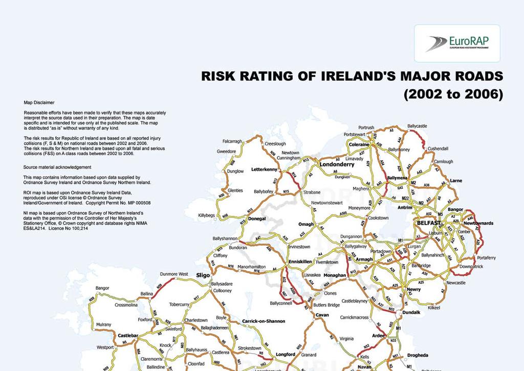
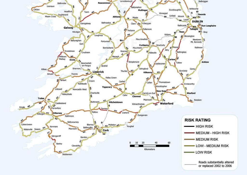
2 2 Foreword (Motoring Clubs) The AA, Roads Service Northern Ireland and the National Roads Authority have been working closely together on the European Road Assessment Programme (EuroRAP) project since This report follows on from its predecessor, published in 2005, and is a continuation and expansion of that collaborative work. EuroRAP has grown to become an important tool for road authorities and road designers across Europe and beyond. EuroRAP provides safety ratings that enable high-risk sections of road to be identified and mapped. The ratings provide road engineers and designers with vital benchmarks to show them how well or how badly their roads compare with others in their own region, country and elsewhere. It encourages the implementation of existing good practice and promotes the use of new and better road design measures that can reduce the threat of injury in a collision. This report contains an update of the previously published risk rate map for Ireland. Based on historical data collected in the five year period from 2002 to 2006 inclusive, it shows roads and routes where the risk of injury or death is greatest. The report also contains the results of the first Star Rating assessment of selected roads, North and South, based on the EuroRAP Road Protection Score methodology. EuroRAP is more than an assessment tool. It is an excellent example of cooperation between motoring organisations and roads authorities across international boundaries. Ireland has been part of the project since its inception, and the close working relationship between all the Irish partners has been exemplary. Last year there were 448 people killed in road collisions on the Island of Ireland, and several thousand people were seriously injured. Although the trend is downwards in both jurisdictions this is still a totally unacceptable figure. The sheer scale of the devastation visited upon families right throughout our society is horrifying. How can roads be made safer by design? How can we prevent crashes from happening? How can we get drivers to drive responsibly? When all else fails how can we make roads more forgiving? These challenges are facing road authorities, police forces and communities all over Europe and indeed all over the world. We hope that this report will make a meaningful contribution to our collective efforts to face that challenge. Pat Kiely Managing Director AA Ireland


3 Foreword (Roads Authorities) Both the National Roads Authority (NRA) and Roads Service Northern Ireland are delighted to be involved with AA Ireland and the Road Safety Foundation in the publication of this document. The road authorities have a very close working relationship both with each other and with these groups, with the common goal of increasing road safety on the Island of Ireland. This is the second risk rating map the first having been published in This map shows the progress that has been made over the last number of years. Since the first publication all the Black, High Risk Sections have been removed. There are now no High Risk sections on the Island of Ireland. This is due in no small way to the major motorway and dual carriageway programme underway in the Republic of Ireland, and the many strategic and local road improvements in Northern Ireland. Collision remedial schemes have also been carried out by the NRA, Roads Service and local authorities throughout Ireland. The NRA is implementing a 1.25bn per annum programme of major schemes, a significant proportion of which is ensuring the completion of the new Interurban network of Motorways and Dual Carriageways. The N6 to Galway, N7 to Limerick, N8 to Cork and N9 to Waterford will be completed by In 2001, there were approximately 250km of motorway/dual carriageway in the Republic of Ireland. In 2006, this figure had risen to 625 km and by 2010 it will have risen to 1250km nearly 5 times what it was at the start of the decade. This will bring the Republic of Ireland up to Best Practice levels in other countries, with 23% of the national network being motorway or dual carriageway, a similar figure to that in the UK. There is a significant Road Safety benefit from this infrastructure. It is estimated that this road construction programme will contribute to approximate savings of fifty lives per year when completed in 2010, and thus, be a major contributing factor to reducing road deaths in Ireland. Despite a 17% increase in population in the Republic of Ireland since 1996 and a 71% increase in the number of registered vehicles, road fatalities have decreased by 20%. Out of 125 stretches of road assessed in Northern Ireland, 112 have improved or remained within the same risk band. This confirms that, despite the economic growth and the increase in vehicular traffic throughout the region, there have been significant benefits from the installation of targeted collision remedial and route treatment schemes. The Northern Ireland Executive s Investment Stategy has proposed a level of investment of 3.1bn to 2018 earmarked to improve Northern Ireland s strategic and other roads further to the highest safety standards as well as improving journey time reliability. The road authorities in both jurisdictions take their role in protecting road users from injury very seriously. Our work in aiding the production of this EuroRAP publication is an affirmation of our commitment to road safety on roads throughout Ireland. Fred Barry CEO National Roads Authority Geoff Allister Acting Chief Exective, Road Service Northern Ireland

, which crash tests new cars and gives them ratings for safety.")
4 4 The European Road Assessment Programme What is EuroRAP? EuroRAP is an international not-forprofit association, registered in Brussels, which has been formed by motoring organisations and road authorities throughout Europe to work together for improvements to the safety of Europe s roads. This is an important contribution to the EU millennium goal to reduce the number of deaths on European roads by 50% by It is a sister programme to the European New Car Assessment Programme (EuroNCAP), which crash tests new cars and gives them ratings for safety. EuroRAP produces maps showing the risk of traffic collisions that cause death and life threatening injuries. It highlights sections of road where intervention may be required to reduce the likelihood of collisions taking place in the future. Why has EuroRAP been formed? By giving roads in Europe a safety rating, EuroRAP highlights the risk of death and serious injury on the roads and stimulates discussion on road safety between drivers, government and road safety departments and action. The ratings will also provide road engineers and planners with a clear comparative analysis of how their roads are performing compared with others, both in their own country and in other countries. EuroRAP tells drivers which roads carries the highest risk of death and injury, and so raises their awareness of the danger and encourages safer driving. EuroRAP s objectives are: To reduce deaths and life-threatening injuries on Europe s roads by systematically assessing risk and identifying safety shortcomings that can be addressed with practical road improvement measures. To put assessment of risk at the heart of strategic decisions on route improvements, crash protection and standards of route management. To provide the individual driver with meaningful information on where the greatest levels of risk are faced, and in turn to influence driver behaviour. How does EuroRAP assess risk rates? Based on real collisions and traffic flow data, Risk Rate Maps show a road s safety performance by measuring and mapping the rate at which people are being killed and injured. P4 end terminals enhance the safety at the start of crash barriers Roundabouts can improve safety at junctions.


5 Can our roads ever be made safe? Absolute safety may never be achieved, but EuroRAP believes that preventable deaths which happen again and again on the same roads must not be tolerated. Historical trends have shown that over 90% of crashes result from human error and, therefore, road safety policy has focussed on fixing the driver. Many drivers are inexperienced or act foolishly so driver education programmes for example, on seat belts are crucial. Some drivers will act with criminal disregard for the safety of others and they should expect tough policing and significant penalties, but dangerous roads should not make these offences punishable by death. Many crashes happen when the average driver makes a mistake. Sober, responsible drivers obeying the speed limit and wearing seat belts frequently die on Europe s roads. Protecting against human error is understood in rail, aviation and factory safety. EuroRAP s model for reducing death and injury is based on roads and vehicles that have forgiving designs. When a crash happens, both road and vehicle must work together to minimise the potential for Death or Injury. Since the publication of the first EuroRAP report for Ireland in 2005, there has been a significant improvement in the safety of the road network. This not only reduces the risk of possible collisions, but also reduces the severity of injuries to the occupant of the vehicle when a collision occurs. Regardless of the improvements which have been made, additional work is required to ensure that these improvements continue. The human body cannot tolerate uncushioned forces above 40 kilomtres per hour.
6 6 Update Of Actions & Treatments From 2005 Results. In the 2005 report, EuroRAP identified a number of road sections with potential for route actions, based on the risk rates. Road Safety Remedial work at these locations has been carried out. The following two tables are a review of the original locations in the 2005 publication. In the tables, Column (A) indicates the number of collisions that occurred between 1998 and The cell colour indicates the Risk Value assigned to that section during that period. Column (B) indicates the number of collisions that occurred between 2002 and The cell colour indicates the current Risk Value assigned to the section. There are five categories of Risk; Low Risk, Low Medium Risk, Medium Risk, Medium High Risk, High Risk. NORTHERN IRELAND Road From to County Length (km) A3 A20 A23 A24 A29 A57 Moira to Lisburn (Meadow Road to Governors Road Roundabout Upper Newtownards Road from Knock Road to Dundonald A55 Outer Ring Road at Castlereagh Junction to Ballygowan Forestside to Carryduff Roundabout Moneymore Road to Kings Bridge through Cookstown Junction with A8 at Larne Road to Templepatrick Roundabout Carriageway type Fatal & Serious Collisions (A) (B) Change Works carried out Antrim 11 Single Junction improvement works carried out at a number of locations, provision of right turn lane and sight line improvements. Installed Traffic Signals at Halftown road. Down 4 4 lane single no barrier Pedestrian facilities provided and upgraded, surface improvement works carried out. Traffic signals and Vehicle activated signs (VAS) installed. Down 11 Single Provided improved signing and lining along the route. Down 6 Single Improved pedestrian and cycle facilities provided. Safety camera and improved surfacing also installed. Tyrone 4 Single Junction improvements carried out, pedestrian facilities provided. Antrim 11 Single Replaced two priority junctions with roundabouts. Provided edge of carriageway road markings at locations along this section. Right turn lane provided.
7 REPUBLIC OF IRELAND Road From To County Length (km) Carriageway Type Fatal, Serious and Minor Injury Collisions Change Works carried out N1 Dundalk town to Co. Down border N2 M50 to Ashbourne Dublin / Meath (A) (B) Louth 13 Single Provision of Traffic Calming, Motorway opened in Single Provision of Traffic Calming, plus additional safety works. M50 to Ashbourne replaced with a Dual Carriageway in May N21 Tralee to Castleisland Kerry 16 Single A number of Junction Improvement schemes were completed, a new 3 km section of road was constructed at the Tralee end and opened in km realigned section of the N21 opened in N25 N52 N53 N54 N55 Waterford to Kilmeadan Junction with R400 south of Mullingar to Tyrrellspass Dundalk town to Co. Armagh border Monaghan town to Co. Fermanagh border R394 Castlepollard Rd to Edgeworthstown Waterford 7 Single Pedestrian facilities provided on the N25 within the urban area, Waterford Ring Road open in 2005 Westmeath 15 Single Improved sightlines, resurfacing, junction sightline improvements signing and lining, plus Traffic Calming, in 2007, 6km of this road was bypassed with the N52 Mullingar to Belvedere Road Improvement Scheme Louth 13 Single A number of road safety schemes were implemented along this section of road, these works included sightline improvements, anti skid surfacing, bend definition, and traffic calming. Monaghan 21 Single Provision of Traffic Calming, sightline improvements at junctions and bends, improved bend definition, road edge improvements, pavements, and minor junction realignments. Longford / Cavan 19 Single Bypass of Edgeworthstown, improved junction lining and signing, provision of Traffic Calming and Pedestrian Facilities. N75 Thurles N8 Tipperary 9 Single Provision of Traffic Calming, and some lining and signing work carried out. N78 Athy to R430 Newtown Cross Kildare / Laois 18 Single Improved lining and signing, improved bend definition, Road Surface Improvements, & the provision of Safety Barriers
8
9
10 10 Priorities For Action In Ireland 2008 The 2007 EuroRAP analysis of the network has identified the following road sections as potential priorities for route action. This is based on risk rate and a substantial number of collisions per kilometre. Some work has already been carried out or is planned on these routes under both road authorities programme of routine improvements and upgrading. NORTHERN IRELAND Road From to County Length (km) A2 A3 Main Street Glenariff to Quay Road Roundabout, Ballycastle. Moira to Lisburn (Meadow Road to Governors Road Roundabout Carriageway type Fatal & Serious Collisions Risk rating Comments Antrim 21 Single 21 Medium-High Gateway features and refuge island installed in Cushendall. Collision remedial scheme programmed for route between Ballycastle and Cushendall Antrim 11 Single 22 Medium-High Further studies will be be undertaken to identify if any further safety measures can be introduced A29 Moneymore Road to Kings Bridge through Cookstown Tyrone 4 Single 13 Medium-High A dedicated signalised right turn facility at James Street and erection of gateway speed limit signing programmed for installation in 2008 A50 A54 Edenderry Roundabout, Portadown to Tullyraine Road, Bannbridge Castledawson Roundabout to Church Street Roundabout, Kilrea Armagh 13 Single 22 Medium-High Several collision remedial measures such as high friction surfacing, increased signing, right turn pocket and islands have been installed on the A50. Significant resurfacing also undertaken on route. L derry 24 Single 17 Medium-High Junction and corner improvements and upgrading of signing installed in Ballymacombs/Smithstown Road will be realigned A509 Sligo Road, Enniskillen to Border with Republic of Ireland Fermanagh 29 Single 17 Medium-High Considerable investment in safety measures have been installed since 2006, including enhanced signing, sightline improvements, vehicle activated warning signs and carriageway and footway realignments.
11 REPUBLIC OF IRELAND Road From To County Length (km) N53 M1 to Northern Ireland Border Carriageway Type Fatal, Serious and Minor Injury Collisions Risk Rating Comments Louth 10.7 Single 25 Medium-High Sightline improvements have been made at junctions, improved signing and lining has been installed along long stretches of the N53. N2 N14 N59 N5 N67 N62 N81 N72 N30 Monaghan to Northern Ireland Border Northern Ireland Border to N13 Ballina to Dromore West Longford to Cloonsgannagh Ennistimon to Miltown Bay Templemore to Roscrea Closh Cross to Tullow Castletownroche to Fermoy Enniscorthy to Jamestown Monaghan 16.2 Single 41 Medium-High Improved Signing and Lining has been carried out since Further junction and pedestrian improvements are planned. Donegal 19.8 Single 71 Medium-High Work has been carried out to improve the sightlines at a number of junctions, the definition of a number of bends has also been carried out. Mayo 25.0 Single 50 Medium-High Signing and lining improvements have been carried out, Resurfacing work has been carried out along sections of the road. Further improvements are planned. Longford 13.8 Single 31 Medium-High Improved traffic management carried out in a number of urban areas along the route. Further safety work planned. Clare 15.6 Single 20 Medium-High Signing and Lining work has been carried out at a number of junctions and bends. Additional work is planned. Tipperary 18.2 Single 29 Medium-High Improved Lining and Signing work has been carried out. Carlow 8.94 Single 15 Medium-High Some minor road widening and re-alignment has been carried out. Junction improvement works have also taken place. Cork 15.1 Single 19 Medium-High Carried out improvements to the definition of bends, and junctions. Wexford 4.15 Single 11 Medium-High Bend definition has been improved, additional works under review. The National Roads Authority (Republic of Ireland) and Roads Service NI continually monitor their respective networks. As part of this process all locations mentioned in the above tables will be monitored as part of the regular review of the networks and measures undertaken on the above roads will be evaluated.


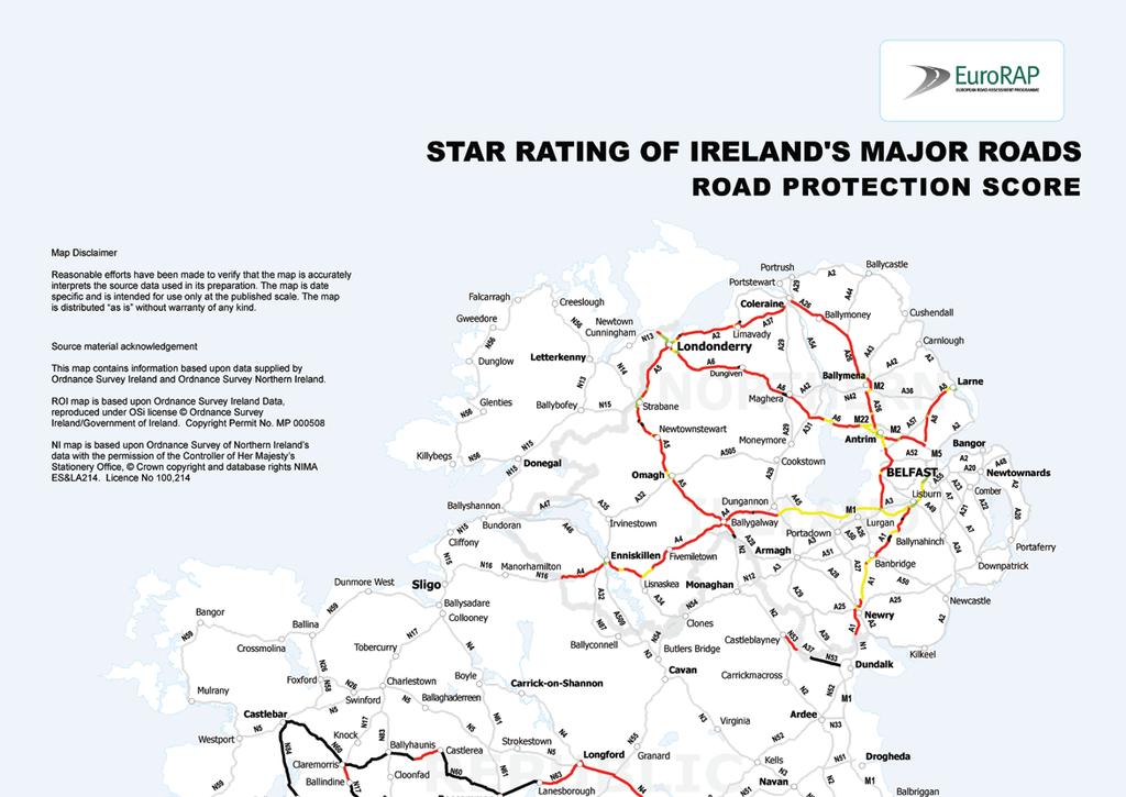
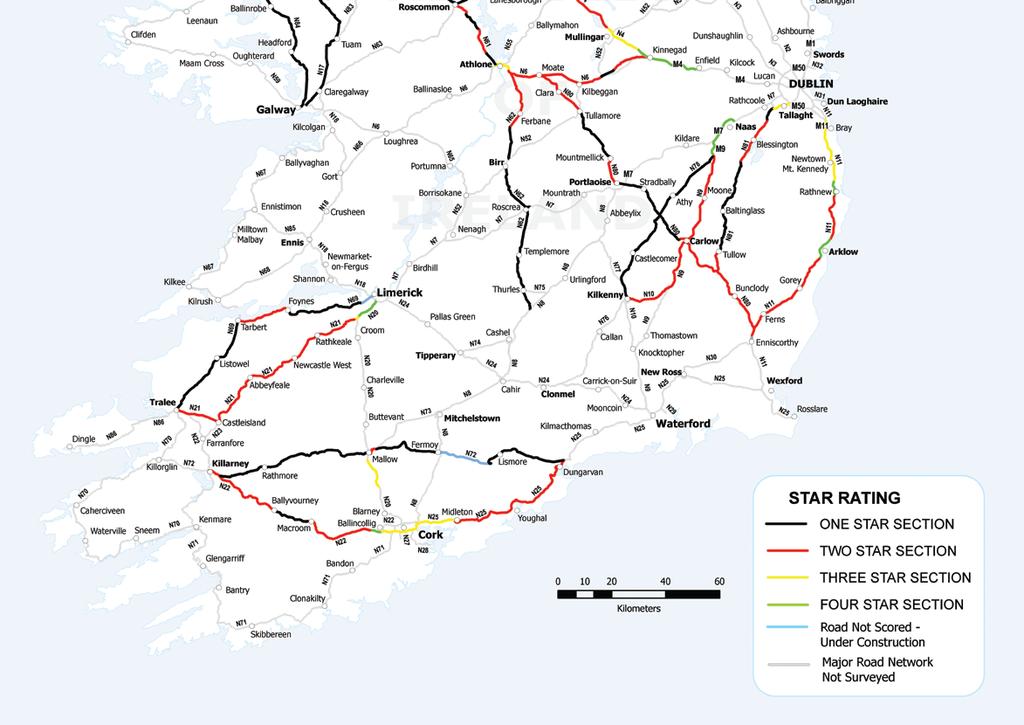
12 12 EuroRAP RPS (Road Protection Score) The Road Protection Score RPS has been developed to assess the protection that the road environment will provide to the occupants of a car in a collision. There are three broad categories of collisions that can be affected by elements of the road design: HEAD-ON collisions are influenced by the design of the road median. A wide grass median with a physical division such as a safety barrier will provide the occupants of the car with more protection than an intermittent centreline. RUN-OFF collisions and their severity can be influenced by the design of the side of the road. A road featuring a wide verge with no hazards is scored as safer than a road with no verge and hazards located within the boundary. INTERSECTIONS influence the outcome of the collision by their design. A free flow off-slip as used on Motorways provides far more protection than a cross-roads on a single carriageway. Smooth flowing traffic movements are facilitated and conflicts avoided compared to crossing traffic at single carriageway junctions. Each category has a weighting applied to each of these collision types. The relative weighting represents an average European collision type distribution agreed by the EuroRAP Technical Committee. The influence of aggressive roadside objects is calculated from the likely severity of collision injury. It also incorporates the distance from the edge of the running lane, to allow for driver reaction and speed at impact. Junctions are rated on the likely angle of impact and the differential in speeds between the vehicles involved in the collision. The presence of turning lanes to protect turning vehicles from through traffic is also taken into account. The junction score for a section of road takes into account the number and quality of the intersections along the length of the route. Based on these road design elements, Star Ratings from 1 through to 4 are awarded, with a 1 star road being the lowest category.

13 Routes Selected for the RPS Survey. This is the first developmental RPS Survey for Ireland, and it is worth stressing that the work was carried out only on a selected sample of roads North and South. Routes were carefully chosen to include the full range of road types from motorways to single carriageways within each of the networks. In Northern Ireland, primary routes were identified and assessed. The survey looked at the strategic road network and covered a length of 620km, focussing on the routes that link the main areas of population. In the Republic, paired routes were selected for assessment. It was decided to carry out the survey on links between towns where there was generally more than one route available to the driver For example, from Dungarvan to Killarney a driver can choose to travel via the N25 or the N72; from Dublin to Enniscorthy a driver can choose to travel via the N11 or the N81. This allows the driver to look at alternative routes between two points and to see which of these routes offers greater protection. Data on road design and the standard of a road s safety features is collected by drive-through inspections in specially equipped vehicles. Two of these vehicles crewed by EuroRAP technicians from Sweco Consultants of Sweden and ADAC consultants of Germany carried out the Irish inspections, noting hazards under a detailed scoring scheme. Point and linear hazards were recorded with GPS references as the road was driven, with video of the roads captured throughout the inspections to allow for later analysis. Northern Ireland Km Republic of Ireland: Km (Strategic Corridors 620kms) Larne to Newry via Belfast A8/A1 Belfast to Londonderry via Dungiven A2/A6 Belfast to Derry via Coleraine A26/A2 Derry to Aughnacloy via Omagh A5 Belfast to Enniskillen & Border M1/A4 (Paired Routes 1100kms) 103 Dublin to Enniscorthy via Baltinglass (a) N81, N Dublin to Enniscorthy via Gorey (b) N11, M Naas to Kilkenny via Carlow (a) M9, N9, N10 85 Naas to Kilkenny via Athy (b) N78, M9 150 Enfield to Roscommon via Longford (a) M4, N4, N63 Enfield to Roscommon via Athlone (b) M4, N6, N61, Castlebar to Galway via Tuam (a) N60, N17 Castlebar to Galway via Ballinrobe (b) N84 Limerick to Tralee via Listowel (a) N69 Limerick to Tralee via Abbeyfeale (b) N20, N21 Killarney to Dungarvan via Mallow (a) N22, N72 Killarney to Dungarvan via Cork (a) N22, N (Single Routes 288kms) Dundalk to Castleblayney - N53 17 Passively Safe street furniture can reduce the energy from a vehicle collision and may substantially reduce the severity of injuries. Roscommon to Claremorris - N60 65 Athlone to Thurles via Birr - N Moate to Enniscorthy via Portlaoise - N80 143

 Allow drivers to exit from the mainline at a similar speed to the mainline traffic, this reduces the risk of collisions as a result of differential speeds.")
14 14 Star Rating When assigning a star rating to a section of road, EuroRAP looks at each of the features of the road which either increase the risk to the occupant of the vehicle or decreases the risk to the occupant of the vehicle. The following images set out to illustrate these features. Reduce Risk Divided Carriageway (1) A physical barrier separating vehicles greatly reduces the risk of head-on collisions. Free Flow Exit-Slips (2) Allow drivers to exit from the mainline at a similar speed to the mainline traffic, this reduces the risk of collisions as a result of differential speeds. All junction manoeuvres are carried out away from the mainline. Wide Driving Lanes (3) Wide driving lanes reduces the risk of inadvertently straying out of their driving lane into the lane beside them. Hard Shoulder (4) Hard Shoulders provide a place to stop in the event of an emergency, they also provide the driver with a recovery area in the event of something unexpected occurring resulting in them losing control of their vehicle, while also increasing the distance between the vehicle and roadside hazards. EXAMPLES OF FOUR AND THREE STAR ROADS Typical of 4 Star Road Typical of 3 Star Road 5 6 Increase Risk At Grade Junctions (5) At grade T-Junctions on dual carriageways, can result in drivers slowing down on the mainline, which can result in a greater risk of rear-end collisions. Median Crossings (6) Median crossings on dual carriageways can lead to conflicts between drivers on the mainline and drivers attempting to cross the road

, increases the distance between the driver and the roadside hazard Typical of 2 Star Road 3 6 4 7 8 1 Due to the presence")
15 Reduce Risk EXAMPLES OF TWO AND ONE STAR ROADS Increase Risk Clear Lining (1) Lack of overtaking opportunities (7) Continuous centre line and/or hatching on the approach to the junction on the left-hand side opposite the dwelling. Prohibits overtaking on the approach to a junction Edge Definition (2) Edge road markings, clearly defines the edge of the carriageway to the driver of the vehicle Hard Shoulder (3) Safe place to stop in an emergency, Place for slower moving vehicle s to move into (in ROI), increases the distance between the driver and the roadside hazard Typical of 2 Star Road Due to the presence of the junctions, entrances or the alignment of the road there can be a lack of overtaking opportunities, This can lead to driver frustration leading to them making inappropriate decisions Roadside Hazards (8) Existing hazards such as telegraph poles and mature trees. Private dwellings located along the road edge, can lead to conflict between mainline drivers and residents attempting to enter or exit their property Existing hedgerows can include hazards such as trees, drains, walls etc. Provision of Right Turn Lane (4) A right turn lane has been provided, this reduces the need for a driver to stop on the mainline while turning right Lining (5) Continuous centre line on the approach to the junction on the left-hand side opposite the dwelling, prohibits overtaking on the approach to a junction Edge Definition (6) Edge road markings, clearly defines the edge of the carriageway to the driver on the mainline Typical of 1 Star Road Lack of Hard Shoulders / Narrow Verges (9) The lack of hard shoulders or narrow verges can result in drivers travelling closer to the ditches, and junctions etc, which may be potential hazards Narrow Carriageway (10) The narrow driving lanes, increases the risk of a driver straying out of their lane into the oncoming lane. No Central Reserve for Right Turning Traffic (11) The narrow carriageway does not allow for the provision of a right turn lane that results in drivers having to wait on the mainline, thus increasing the risk of rearend collisions.
16
17
18 18 How Ireland Compares Summary of Star Rating Results The map showing the overall Star Rating for both road networks is shown on the previous page. The charts show the proportion of Star Ratings achieved for the various road networks surveyed. These are broken down by carriageway type and compared with similar surveys in Great Britain and Germany. The Star Rating results are based on a sample of each network surveyed and therefore do not accurately represent the entire network. Other Roads * Motorways Secondary Single Star Rating ROI 0% 20% 40% 60% 80% 100% Star breakdown of ROI other roads Other Roads Motorways 0% 20% 40% 60% 80% 100% Other Roads Star Rating NI Star Rating GB Primary Single Star Rating Motorways 4 **** 3 *** 2 ** Dual 0% 20% 40% 60% 80% 100% 1 * * Other roads include both Dual and Single Carriageways. 0% 20% 40% 60% 80% 100% Star Rating Germany Other Roads Motorways 0% 20% 40% 60% 80% 100%

19 The charts on the previous page compare the Star Rating with the various carriageway types, for example in the Republic of Ireland, 85.5% of its Motorways are 4 star, with the remaining 14.5% being 3 Star. The newly constructed Motorways and Dual Carriageways in the Republic of Ireland which have been designed to the highest standards are achieving a 4 Star Rating. The current major inter-urban road building programme is being completed to the same high design standards as the sections of Motorway and Dual Carriageways which achieved a 4 Star Rating during the EuroRAP RPS Survey. The NRA looks to achieve a 4 Star Rating when the construction of the current Motorways and Dual Carriageways are completed. Although the performance of the dual carriageways in Northern Ireland is broadly comparable with other countries, Roads Service is aware, from analysis of collision data, that there is a higher than normal proportion of crashes caused by crossing and right turning movements. Most of the dual carriageways in the region were constructed to the lower standards prevailing about thirty years ago, often building a carriageway parallel to an existing single carriageway road and many opportunities for vehicle crossing movements were allowed to remain. This is especially evident on the A1 road between Lisburn and Newry, where there are many breaks in the central median and sides of the road to allow access to private properties and minor roads. The increased risks that these layouts pose has been recognised by Roads Service which has embarked on a programme of work on the A1 to upgrade junctions and install protective measures in the central median. Similar road protection score surveys have been carried out in other European countries such as Sweden, Spain, Germany, Iceland, and the Netherlands.
20 20 How Ireland Compares Comparison of Risk Rating versus Star Rating Republic of Ireland High Risk Medium - High Risk Medium Risk Low - Medium Risk Low Risk ** Not Scored 0% 20% 40% 60% 80% 100% Northern Ireland High Risk Medium - High Risk Medium Risk Low - Medium Risk Low Risk Not Scored 0% 20% 40% 60% 80% 100% The EuroRAP RPS Survey was carried out on a number of new sections of road, roads which were opened after While these sections do not have five years of collision data and can not therefore have a risk rating assigned to, it is hoped that they will perform as well as the other sections of road built to the same standards 33% of 4 Star Roads are Low Risk in the Republic of Ireland and 49% in Northern Ireland 58% of 1 Star Roads are Medium High Risk in the Republic of Ireland and 17% in Northern Ireland There are currently no high risk sections of road on the network. When compared with the first risk rating review carried out in 2005, this shows that considerable progress has been made reducing the risks to drivers on the network. While the Star Rating for the Republic of Ireland indicates large sections of 1 and 2 star roads, these are primarily found on the older non designed sections of the network. Sections of road which were not designed to today s high standards are narrow, with a high percentage of junctions and private entrances accessing on to them. This results in them having a low Star Rating, but we can see from the comparison of Risk v Star Ratings table, on the left, the actual risk faced by drivers on these sections of road is largely in the medium risk category. Comparison of fatal collision rates per billion vehicle km among EuroRAP Partners Republic of Ireland Northern Ireland Great Britain Netherlands Sweden Spain Motorway (2.9) (1.7) Star Rating 4 **** 3 *** 2 ** 1 * ** Not Scored is for sections of road which have been opened since 2002, and do not have sufficient collision records to allow a valid risk valuce to be calculated. Dual Carriageway Single Carriageway (4.9) (5.1) Values in brackets indicate small samples, so these collision rates should be viewed as indicative of the average for these types of roads. Data for the Republic of Ireland and Northern Ireland are ; time periods for other countries differ.

21 A review of the Type 3 (2+1) Road Type Type 3 pilot projects In 2003 the NRA decided to progress several Type 3 pilot projects (generally known as 2+1 format) on the national primary road network. To date two retrofit pilot Type 3 projects have been implemented: on the N20 Mallow Rathduff road and on the N24 Piltown Fiddown Bypass, as well as a Greenfield pilot Type 3 road type opened in November 2007 on the N2 between Clontibret and Castleblayney. Valuable lessons have been learnt from these retrofit projects. An Operational Safety Review of the 1st retrofit scheme in Cork highlighted several positive outcomes regarding the scheme, including: The total lack of head-on and overtaking collisions. The ongoing reduction in maintenance as time passes. The emergency services have indicated a positive attitude to the scheme. The apparent acceptance by adjacent landowners to the movement restrictions. This Type 3 pilot project on the N20 in Co. Cork opened to traffic in April 2005, has been well received by the public and carries traffic volumes of up to 16,000 AADT. The provision of a wire rope safety barrier in the median on the N20 pilot Type 3 project has not posed any particular difficulties for motorists. The report concluded that the Type 3 road type feels safe to drive and that the introduction of a wire rope barrier on a narrow median is acceptable for Irish conditions. The main disadvantage of the Type 3 road type is that, at high operating flows, they will give rise to aggressive driving behaviour at the critical changeover locations, whereby drivers travelling on the 2-lane section are merging to one lane. This may give rise to a shunt effect. In other words, bottlenecks may be created at the 2-lane merge section at critical hourly traffic flows. It is noted that, in Sweden, traffic volumes on much of the Type 3 network does not exceed 12,000 AADT. The Type 3 road type remains for projects where the design year flows are between 11,600 and 14,000 AADT, however their use will generally be limited to retrofit projects. This capacity figure is based on a low level of frontage access which may be difficult to achieve on some retrofit projects. Indeed the level of frontage may curtail the length of Type 3 projects to a level well below that originally anticipated. Type 2 (2+2) Road Type The results of the Type 3 pilot project prompted consideration of a Type 2 road type, as a variant on the options between the standard single carriageway and a high quality dual carriageway. The Type 2 road type consists of two lanes in both directions separated by a physical median barrier. For safety reasons, a 4 lane undivided road is considered unacceptable on rural sections of the network where a 100kph speed limit applies. The proposed paved width of a Type 2 road is 16.5 m. The proposed width of the traffic lane is 3.5m. The second lane should function mainly as an overtaking lane only and its width is also 3.5m. The 1st pilot Greenfield Type 2 road was opened in December 2007 on the N4 between Dromod and Roosky. This project is being closely monitored by the Authority. The Type 2 road is to be considered as a cross section option as traffic flows between 11,600 Annual Average Daily Traffic AADT (i.e. the capacity limit of a standard single carriageway) and 20,000 AADT in the design year. At the lower end of the range, a Type 2 road will normally be preferable to a wide single carriageway, while at the upper end it could be considered instead of a Dual Carriageway.


22 22 EuroRAP Risk-Rating Maps There are five categories of Risk; Low Risk, Low Medium Risk, Medium Risk, Medium High Risk, High Risk. Great Britian Czech Republic Maps for other countries are indicative only as different types of roads on their networks may have been surveyed. Ireland Belgium Austria Netherlands


23 RPS Score 4 **** 3 *** 2 ** 1 * Not selected Maps for other countries are indicative only as different types of roads on their networks may have been surveyed. Ireland EuroRAP Star-Rating Maps Sweden Switzerland Iceland Netherlands
24 EuroRAP in Ireland This report contains an update of the previously published risk rate map for the Island of Ireland. Based on historical collision data collected in the five year period from 2002 to 2006 inclusive, it shows roads and routes where the risk of injury or death is greatest. The report also contains the results of the first Star Rating assessment of selected roads, North and South, based on the EuroRAP Road Protection Score methodology. This rates the safety built in to the road, based on how well its design would protect car occupants from severe injury in a collision. The score is used to give each road a Star Rating, varying from 1 to 4, with a 4-star stretch representing a road engineered to minimise the likelihood of a severe injury to car occupants. EuroRAP AISBL is an international not-for-profit association registered in Belgium The EuroRAP programme is enabled in the UK and Ireland by the Road Safety Foundation. EuroRAP is financially supportedby the European Commission, the FIA Foundation for the Automobile and Society, Toyota Motor Europe and ACEA (the European Automobile Manufacturers Association) EuroRAP AISBL Worting House Basingstoke Hampshire RG23 8PX brenda.king@eurorap.net Road Safety Foundation Contact details same as EuroRAP AA Ireland Maryland House South William Street Dublin 2 eurorap@aaireland.ie Published by AA Ireland and EuroRAP AISBL, May EuroRAP AISBL is grateful to the Road Safety Foundation, registered charity , for it s help and support. This information is copyright and may be re-used for non-commercial purposes provided the source is acknowledged. Photos courtesy of the National Roads Authority (Republic of Ireland) and Roads Service Northern Ireland. Llywodraeth Cynulliad Cymru Welsh Assembly Government
NRA New Divided Road Types: Type 2 and Type 3 Dual-carriageways
 NRA New Divided Road Types: Type 2 and Type 3 Dual-carriageways BENEFITS of the TYPE 2 and TYPE 3 DUAL CARRIAGEWAY ROAD TYPE There are significant safety and economic benefits associated with the Type
NRA New Divided Road Types: Type 2 and Type 3 Dual - Carriageways
 NRA New Divided Road Types: Type 2 and Type 3 Dual - Carriageways DN-GEO-03059 December 2007 DN Design Technical TRANSPORT INFRASTRUCTURE IRELAND (TII) PUBLICATIONS About TII Transport Infrastructure Ireland
Helen Hughes Senior Project Manager
 Helen Hughes Senior Project Manager hhughes@nra.ie What is a 2+1 Road? A road with two lanes in one direction and one in in the other The two lane section is provided alternately for each direction of
The EuroRAP Journey Success is a journey, not a destination
 Success is a journey, not a destination EuroRAP began as an idea in 1999 to address the unnecessary and preventable toll of death and serious injury on Europe s roads. Within the Safe System approach,
TRANSPORT INFRASTRUCTURE IRELAND NATIONAL ROAD NETWORK INDICATORS March 2017
 TRANSPORT INFRASTRUCTURE IRELAND NATIONAL ROAD NETWORK INDICATORS 2016 March 2017 KEY TRENDS A: KEY TREND SUMMARY 2 TRAVEL HOTSPOTS: TRAFFIC GROWTH: M50 Dublin area: 140,000 vehicles per day Hotspot: N40
Cork to Limerick Route Pre-Feasibility Study Update
 Cork to Limerick Route Pre-Feasibility Study Update November 2008 Document Title: Cork to Limerick Route Pre-Feasibility Study Update Document Ref(s). : Date Rev Status Originator Checked Approved 01/12/08
Discover the Safe System Approach
 Discover the Safe System Approach Aim Take you on a journey of discovery Inform, engage, enthuse and share with you the Safe System approach to saving death and injury on our roads Change to less graphic
Road Safety Audit training course. Motorways - safety issues of the motorway design
 Road Safety Audit training course Motorways - safety issues of the motorway design Jesper Mertner, Road safety auditor, COWI A/S 1 ROAD SAFETY AUDITING COURSE Content 1. Safety 2. Cross sections 3. Horizontal
Star Rating Roads For Safety
 Star Rating Roads For Safety The EuroRAP Methodology Consultation version 16 September 2009 ` EuroRAP505.04 Star Rating Roads For Safety: The EuroRAP Methodology Page 2 About EuroRAP The European Road
Police Recorded Injury Road Traffic Collisions and Casualties Northern Ireland. Detailed Trends Report 2015
 Police Service of Northern Ireland Police Recorded Injury Road Traffic Collisions and Casualties Northern Ireland Detailed Trends Report 2015 Annual Bulletin Published 30 th June 2016 Contact: Traffic
BUILDING CHINARAP. Zhang Tiejun Research Institute of Highway (RIOH) Beijing, China
 Beijing, China") BUILDING CHINARAP Zhang Tiejun Research Institute of Highway (RIOH) Beijing, China E-mail: tj.zhang@rioh.cn Greg Smith International Road Assessment Programme (irap) Beijing, China E-mail: greg.smith@irap.org
BUILDING CHINARAP Zhang Tiejun Research Institute of Highway (RIOH) Beijing, China E-mail: tj.zhang@rioh.cn Greg Smith International Road Assessment Programme (irap) Beijing, China E-mail: greg.smith@irap.org
2003 road trauma for. Wairoa District. Road casualties Estimated social cost of crashes* Major road safety issues WAIROA DISTRICT JULY 2004
 WAIROA DISTRICT JULY 24 T he Land Transport Safety Authority (LTSA) has prepared this road safety issues report. It is based on reported crash data and trends for the 1999 23 period. The intent of the
EUROPEAN ROAD ASSESSMENT PROGRAMME EuroRAP I (2003) TECHNICAL REPORT
 TECHNICAL REPORT") EUROPEAN ROAD ASSESSMENT PROGRAMME EuroRAP I (2003) TECHNICAL REPORT by David Lynam, Ton Hummel, Judith Barker (TRL) and Stephen D Lawson (The AA Motoring Trust) May 2004 CONTENTS EUROPEAN ROAD ASSESSMENT
EUROPEAN ROAD ASSESSMENT PROGRAMME EuroRAP I (2003) TECHNICAL REPORT by David Lynam, Ton Hummel, Judith Barker (TRL) and Stephen D Lawson (The AA Motoring Trust) May 2004 CONTENTS EUROPEAN ROAD ASSESSMENT
Road Safety Inspection. Matt Chamberlain RSA Road Safety Consultants Ltd
 Road Safety Inspection Matt Chamberlain RSA Road Safety Consultants Ltd So What is a Road Safety Inspection? Is an ordinary periodical verification of the characteristics and defects of an operational
C.A.R.S. Project Design Report.
 C.A.R.S. Project Design Report. PRODUCED BY: Browne, A. Kennedy, M. Dolan, N. Selman, C. STUDENT NO: DATE DUE: COURSE: LECTURER: C09365788-C09686908-D11125480-C08868352 20-April-2012 Dt004/3 Civil Engineering
EuroRAP 2009 Results. Murska Sobota. Gornja Radgona. Lendava Ljutomer. Slovenj Gradec. Maribor. Ptuj. Ormož. Jesenice Velenje. Slovenska.
 Gornja Radgona Murska Sobota Slovenj Gradec Maribor Lendava Ljutomer Jesenice Velenje Slovenska Ptuj Ormož Tolmin Kranj Celje Trbovlje LJUBLJANA Litija Nova Gorica Idrija Krško Trebnje Novo mesto Postojna
2015 Victorian Road Trauma. Analysis of Fatalities and Serious Injuries. Updated 5 May Page 1 of 28. Commercial in Confidence
 2015 Victorian Road Trauma Analysis of Fatalities and Serious Injuries Updated 5 May 2016 Page 1 of 28 Commercial in Confidence VICROADS_n3445896_2015_Victorian_Trauma_Report_- _updated_may_2016.docx 2015
Making Road Travel as Safe as Rail and Air ROAD SAFETY FOUNDATION ANNUAL TRACKING REPORT AND REGIONAL ANALYSIS
 Embargo: 00.01 hrs Monday 14 November 2016 Sponsored by Ageas Making Road Travel as Safe as Rail and Air ROAD SAFETY FOUNDATION ANNUAL TRACKING REPORT AND REGIONAL ANALYSIS Travelling on our road system
EuroRAP s priorities. Road Safety: no Safe System without forgiving roads
 EuroRAP s priorities Our European Context Last 10 years 500,000 killed or serious trauma Majority outside cities & towns 5 serious traumas per km on main roads Annual crash cost 2% of GDP 50% Reduction
SLOUGH Stage 3 Road Safety Audit of A4 London Road, M4 J5 to Sutton Lane
 SLOUGH Stage 3 Road Safety Audit of A4 London Road, M4 J5 to Sutton Lane Exception Report Client Officer Rudo Beremauro Date 20 January 2015 RSA /Project Sponsor s Contents Section 3 Project Sponsor's
irap irap The world road safety problem irap Background irap Aims A Safe Road System Vaccines for Roads 1. irap Background 2. irap Malaysia Results
 irap irap 1. irap Background 2. irap Malaysia Results Rob McInerney, CEO irap Asia Pacific 3. irap Worldwide 4. The challenge The world road safety problem A Safe Road System Road 1.2 million killed every
Cycle traffic and the Strategic Road Network. Sandra Brown, Team Leader, Safer Roads- Design
 Cycle traffic and the Strategic Road Network Sandra Brown, Team Leader, Safer Roads- Design Highways England A Government owned Strategic Highways Company Department for Transport Road Investment Strategy
National Planning Framework National Development Plan ( )
") Project Ireland 2040 National Planning Framework National Development Plan (2018-2027) Tara Spain Head of Land Use Planning TII Geraldine Fitzpatrick Head of Roads Capital Programme TII. September 2018
Project Ireland 2040 National Planning Framework National Development Plan (2018-2027) Tara Spain Head of Land Use Planning TII Geraldine Fitzpatrick Head of Roads Capital Programme TII. September 2018
The Road Users Perspective and KiwiRAP
 The Road Users Perspective and KiwiRAP Mike Noon General Manager Motoring Affairs NZ Roadmarkers Federation Conference August 09 What is the AA and why does it care? Club with 1.25m Members Not for profit
Rhebogue Neighbourhood Greenway. Road Safety Audit Stage 2
 Rhebogue Neighbourhood Greenway Road Safety Audit Stage 2 Report Number: 12/007/00/00057 July 2014 Mid West National Road Design Office Lissanalta House, Dooradoyle County Limerick Tel: 061 496 800 Fax:
Plan Purple Proposal. All Ireland Championship. Plan Purple - #FixTheFixtures
 Plan Purple Plan Purple Proposal Fixture list for the GAA season based on the club season is being defined as: 1. The month of April 2. From August 1 st to December 31st How would this be possible? 1.
TEST OF ENGLISH FOR EDUCATIONAL PURPOSES
 TEST OF ENGLISH FOR EDUCATIONAL PURPOSES Practice Test 2 SOURCE BOOKLET University of Reading 2007-12 Questions relating to the following text are in the Task Booklet University of Reading 2007-12 page
Access Location, Spacing, Turn Lanes, and Medians
 Design Manual Chapter 5 - Roadway Design 5L - Access Management 5L-3 Access Location, Spacing, Turn Lanes, and Medians This section addresses access location, spacing, turn lane and median needs, including
Star Ratings for the Strategic Road Network. Richard Leonard - Highways England
 Star Ratings for the Strategic Road Network Richard Leonard - Highways England Strategic Direction for Road User Safety 2 Delivery Plan Star Rating - Commitments We will ensure that by the end of 2020
A127/A130 Fairglen Interchange Improvement Schemes. Information Leaflet February 2017
 A127/A130 Fairglen Interchange Improvement Schemes Information Leaflet February 2017 1 2 Foreword By Councillor Kevin Bentley Essex is continuing to grow as a vibrant economic hub and as a fantastic place
road safety issues 2001 road toll for Gisborne district July 2002 Road user casualties Estimated social cost of crashes*
 GISBORNE DISTRICT road safety issues July 22 The Land Transport Safety Authority (LTSA) has prepared this Road Safety Issues Report. It is based on reported crash data and trends for the 1997 21 period.
Lincolnshire JSNA: Road Traffic Accidents
 Road Traffic Accidents What do we know? Summary A higher proportion of road traffic collisions in Lincolnshire result in death compared to other areas. This may be due to the types of road in the County
The implementation of a 2+1 road scheme in Ireland: a case for Australia?
 The implementation of a 2+1 road scheme in Ireland: a case for Australia?, E. 1 1 M Eng; MICE; CEng Parsons Brinckerhoff, Australia email: egazzini@pb.com.au Abstract This paper describes the implementation
Interim Report on the Development of Road Safety Infrastructure Facility Design Standard for the Asian Highway Network
 Development of Road Infrastructure Safety Facility Standards Expert Group Meeting on Asian Highway United Nations Economic and Social Commission for Asia and the Pacific 3-4 October 2016 Interim Report
1 VicRoads Access Management Policies May 2006 Ver VicRoads Access Management Policies May 2006 Version 1.02
 1 VicRoads Access Management Policies May 2006 Ver 1.02 VicRoads Access Management Policies May 2006 Version 1.02 2 VicRoads Access Management Policies May 2006 Ver 1.02 FOREWORD FOR ACCESS MANAGEMENT
Road Safety Vademecum
 Road Safety Vademecum Road safety trends, statistics and challenges in the EU 2010-2013 March, 2014 European Commission DG for Mobility and Transport Unit C.4 Road Safety Contents Summary of findings...
THE IRAP ROAD SAFETY TOOLKIT A WEBSITE-BASED APPROACH TO ADDRESSING ROAD SAFETY PROBLEMS
 THE IRAP ROAD SAFETY TOOLKIT A WEBSITE-BASED APPROACH TO ADDRESSING ROAD SAFETY PROBLEMS Blair TURNER Principal Research Scientist, Safe Systems Division ARRB Group Ltd 500 Burwood Highway, Vermont South,
2. Context. Existing framework. The context. The challenge. Transport Strategy
 Transport Strategy Providing quality connections Contents 1. Introduction 2. Context 3. Long-term direction 4. Three-year priorities 5. Strategy tree Wellington City Council July 2006 1. Introduction Wellington
1. Restructuring the Provincial Championships and All Ireland Championships.
 Plan Green Plan Green Proposal Fixture list for the GAA season based on the club season is being defined as: 1. The month of April 2. From August 1 st to December 1st How would this be possible? 1. Restructuring
June Presentation Title. Peter Daly RACV. Presenter s Name
 June 17 2008 Presentation Title Peter Daly RACV Presenter s Name Overview What AusRAP is and isn t What it is trying to achieve How it works Key results Future directions What is AusRAP? Sister program
Irish Telephony Numbering Scheme Status Report - March 1998
 Status Report - March 1998 Document No. 98/08 Oifig an Stiúrthóra Rialála Teileachumarsáide Office of the Director of Abbey Court, Irish Life Centre Lower Abbey Street, Dublin 1. Telephone +353-1-804 9600
Bicycle - Motor Vehicle Collisions on Controlled Access Highways in Arizona
 Bicycle - Motor Vehicle Collisions on Controlled Access Highways in Arizona Analysis from January 1, 1991 to June 30, 2002 Richard C. Moeur, PE Traffic Design Manager, Northern Region Michelle N. Bina
Report from Embassy Visit to Copenhagen May David Arditti
 Report from Embassy Visit to Copenhagen May 2013 David Arditti Standard CPH cycle track, one-way 1.5 2m wide, 5cm above carriageway, 5cm below footway Basic one-way cycle track protected by car parking
Kings Road, Herne Bay: Proposed Crash Remedial Measure
 Kings Road, Herne Bay: Proposed Crash Remedial Measure To: Canterbury Joint Transportation Board 17 February 2015 By: Classification: Ward: Tim Read - Head of Transportation Unrestricted Herne Bay Summary:
Star rating roads for safety UK trials
 STAR RATING EUROPE S ROADS FOR SAFETY Star rating roads for safety UK trials 2006-07 James Castle, David Lynam, Jennifer Martin (TRL) Stephen D Lawson (EuroRAP) and Norbert Klassen (ADAC) www.eurorap.org
ROADCASUALTY&COLLISION REPORT 2013
 ROADCASUALTY&COLLISION REPORT 213 Údarás Um Shábháilteacht Ar Bhóithre Road Safety Authority Contents Introduction 2 Executive Summary 3 Overview 4 Road Collision Fatalities 213 5 Casualties 7 Who was
CHECKLIST 2: PRELIMINARY DESIGN STAGE AUDIT
 CHECKLIST 2: PRELIMINARY DESIGN STAGE AUDIT 2.1 General topics 2.1.1 Changes since previous audit Do the conditions for which the scheme was originally designed still apply? (for example, no changes to
Frascati Road and Temple Hill Route Improvements. Outline Design Report to Accompany Public consultation
 Frascati Road and Temple Hill Route Improvements Outline Design Report to Accompany Public consultation September 2013 Background: Dún Laoghaire-Rathdown is committed to providing high quality pedestrian
6. BREENS/GARDINERS/HAREWOOD INTERSECTION - SAFETY IMPROVEMENT PROJECT
 6. BREENS/GARDINERS/HAREWOOD INTERSECTION - SAFETY IMPROVEMENT PROJECT General Manager responsible: Officer responsible: Author: Jane Parfitt General Manager City Environment DDI 941 8656 Michael Aitken
International cooperation to improve the safety of European pedestrian crossings
 International cooperation to improve the safety of European pedestrian crossings Francesco Mazzone Head of International Assessment Programmes ACI Automobile Club d Italia Polis Conference Barcelona, 25
Safer Verges and the Strategic Road Network
 Safer Verges and the Strategic Road Network Gavin Williams Senior Technical Advisor Vehicle Restraints Outline The Journey from Highways Agency to Highway England Overview of the Highways England Health
Reduction of Speed Limit at Approaches to Railway Level Crossings in WA. Main Roads WA. Presenter - Brian Kidd
 Australasian College of Road Safety Conference A Safe System: Making it Happen! Melbourne 1-2 September 2011 Reduction of Speed Limit at Approaches to Railway Level Crossings in WA Radalj T 1, Kidd B 1
ROAD SAFETY PERFORMANCE REVIEW Capacity Building Workshop for Uganda. irap METHODOLOGY Racheal M. N. Nganwa AfricaRAP Lead 1 & 2 March 2018
 ROAD SAFETY PERFORMANCE REVIEW Capacity Building Workshop for Uganda irap METHODOLOGY Racheal M. N. Nganwa AfricaRAP Lead 1 & 2 March 2018 About irap: Registered charity Vision: a world free of high risk
Setting Regional and National Road Safety Targets
 10 th Meeting of the United Nations Road Safety Collaboration 3-4 June 2009, Bangkok Setting Regional and National Road Safety Targets Commemorating 60 years in Thailand 1949-2009 Lives at stake people
DESIGN CODE. Enterprise West Harlow London Road North Design Code 21
 DESIGN CODE Enterprise West Essex @ Harlow London Road North Design Code 21 4 MAXIMUM BUILDING HEIGHTS 4.1 Table 4A sets out maximum building height standards for each character area within the LDO boundary.
The role of the Authority in promoting sustainable transport. Gerry Murphy South East Regional Assembly 27 th May 2011
 The role of the Authority in promoting sustainable transport Gerry Murphy South East Regional Assembly 27 th May 2011 Who we are National Transport Authority established on 1 st December 2009 Dublin Transport
10.0 CURB EXTENSIONS GUIDELINE
 10.0 CURB EXTENSIONS GUIDELINE Road Engineering Design Guidelines Version 1.0 March 2017 City of Toronto, Transportation Services City of Toronto Page 0 Background In early 2014, Transportation Services
Rural Economy and Connectivity Committee. Restricted Roads (20mph Speed Limit) (Scotland) Bill: Key Themes Arising from the Online Survey
 (Scotland) Bill: Key Themes Arising from the Online Survey") Rural Economy and Connectivity Committee Restricted Roads (20mph Speed Limit) (Scotland) Bill: Key Themes Arising from the Online Survey Introduction On Friday 9 November 2018, the Rural Economy and Connectivity
Rural Economy and Connectivity Committee Restricted Roads (20mph Speed Limit) (Scotland) Bill: Key Themes Arising from the Online Survey Introduction On Friday 9 November 2018, the Rural Economy and Connectivity
ENFIELD TOWN THE REVISED DESIGN
 TOWN THE REVISED DESIGN We re turning Enfield into a borough that encourages walking and cycling, a place that s easy for all of us to get around however we choose to travel. A greener place, with safer
Introduction Methodology Study area and data collection Results and recommendation Conclusion References
 Introduction Methodology Study area and data collection Results and recommendation Conclusion References It is formal procedure for assessing accident potential and safety performance in the provision
Derby Cycling Group, c/o 126, Station road, Mickleover, Derby, DE3 9FN. Date: 20 th November, 2018.
 Your Ref: Derby City Council Air Quality - Preferred Option Nov 2018 Derby Cycling Group, c/o 126, Station road, Mickleover, Derby, DE3 9FN Date: 20 th November, 2018. 1. Introduction: 1.1. Derby Cycling
LEA BRIDGE ROAD - A STREET FOR EVERYONE Public consultation document
 LEA BRIDGE ROAD - A STREET FOR EVERYONE Public consultation document TELL US Bakers Arms to Leyton Green Road (Section D, E, F) Leyton Green Road to Whipps Cross Roundabout (Section G) YOUR VIEWS www.enjoywalthamforest.co.uk
TRIAL EVALUATION OF WIDE, AUDIO-TACTILE, CENTRELINE CONFIGURATIONS ON THE NEWELL HIGHWAY
 TRIAL EVALUATION OF WIDE, AUDIO-TACTILE, CENTRELINE CONFIGURATIONS ON THE NEWELL HIGHWAY Connell D.J., Smart W.J, Levett S., Cleaver M., Job R.F.S., de Roos M., Hendry T., Foster J., Saffron D... New South
March Maidstone Integrated Transport Strategy Boxley Parish Council Briefing Note. Context. Author: Parish Clerk 2 March 2016
 Context. Author: Parish Clerk 2 The Draft Integrated Transport Policy (DITS) sets out a vision and objectives, and identifies a detailed programme of interventions to support the Maidstone Borough Local
M-58 HIGHWAY ACCESS MANAGEMENT STUDY Mullen Road to Bel-Ray Boulevard. Prepared for CITY OF BELTON. May 2016
 M-58 HIGHWAY ACCESS MANAGEMENT STUDY Prepared for CITY OF BELTON By May 2016 Introduction Missouri State Highway 58 (M-58 Highway) is a major commercial corridor in the City of Belton. As development has
GEOMETRIC DESIGN OF ROUNDABOUTS AND TRAFFIC S IGNAL SIGNAL CONTROLLED
 TD 16/07 and TD 50/04 GEOMETRIC DESIGN OF ROUNDABOUTS AND TRAFFIC SIGNAL CONTROLLED JUNCTIONS DMRB Vol 6 File 6 0 ROUNDABOUTS: INTRODUCTION Principles Roundabout Types Entry Deflection Capacity Visibility
The Irish Sports Council Funding Plans
 The Irish Sports Council Funding Plans 2012 The Irish Sports Council plans, leads and co-ordinates the sustainable development of competitive and recreational sport in Ireland. Irish Orienteering Association
Intersection Safety 6/7/2015 INTERSECTIONS. Five basic elements should be considered in intersection design. Intersection Safety (continued)
") Intersection Safety S. M. SOHEL MAHMUD Assistant Professor Accident Research Institute (ARI), Bangladesh University of Engineering and Technology (BUET) Dhaka-1000, Bangladesh 1 Outline of the Presentation
Intersection Safety S. M. SOHEL MAHMUD Assistant Professor Accident Research Institute (ARI), Bangladesh University of Engineering and Technology (BUET) Dhaka-1000, Bangladesh 1 Outline of the Presentation
The Irish Sports Council Funding Plans
 The Irish Sports Council Funding Plans 2012 The Irish Sports Council plans, leads and co-ordinates the sustainable development of competitive and recreational sport in Ireland. iscgrantsbrochurev7.indd
PART 5 TD 51/03 SEGREGATED LEFT TURN LANES AND SUBSIDIARY DEFLECTION ISLANDS AT ROUNDABOUTS SUMMARY
 DESIGN MANUAL FOR ROADS AND BRIDGES VOLUME 6 SECTION 3 ROAD GEOMETRY HIGHWAY FEATURES PART 5 TD 51/03 SEGREGATED LEFT TURN LANES AND SUBSIDIARY DEFLECTION ISLANDS AT ROUNDABOUTS SUMMARY This document sets
Appendix D Stage 1 Road Safety Audit
 N2 Monaghan Town to Emyvale Road Improvements Part 8 Application Description of Proposed Development Appendi D N2 Monaghan Town to Emyvale, County Monaghan Proposed Pavement and Minor Improvement Scheme
British Road Safety: Presentation 28/10/2009 by Duncan Price, Deputy Head, Road User Safety Division
 British Road Safety: Presentation 28/10/2009 by Duncan Price, Deputy Head, Road User Safety Division New British Road Safety Strategy Vulnerable Road Users Driving During Business Delivery with Local Organisations
Footpath design. A guide to creating footpaths that are safe, comfortable, and easy to use
 Footpath design A guide to creating footpaths that are safe, comfortable, and easy to use November 2013 Contents Introduction / 1 Zoning system / 2 Width / 4 Height / 5 Surface / 5 Footpath elements /
The Cabinet Member for Highways & Streetscene. Aurang Zeb - Head of Highways & Transport
 LONDON BOROUGH OF RICHMOND UPON THAMES Cabinet Member Decision DATE: January 2012 REPORT OF: LEAD OFFICER: SUBJECT: WARDS: The Cabinet Member for Highways & Streetscene Aurang Zeb - Head of Highways &
10 SHERFORD Town Code
 Key Fixes (Ref: Masterplan Book, section 4a. Land Use Budget and Key Fixes ) The Town Plan designs and allocates buildings, streets and spaces as accurately as possible in the understandable absence of
Kentucky s Surface Transportation System
 Kentucky s Surface Transportation System ROAD AND BRIDGE CONDITIONS, TRAFFIC SAFETY, TRAVEL TRENDS, AND NEEDS MARCH 2018 PREPARED BY WWW.TRIPNET.ORG Founded in 1971, TRIP of Washington, DC, is a nonprofit
Agenda Item 34. N11 - Brewery Road Improvement Scheme
 Agenda Item 34 N11 - Brewery Road Improvement Scheme Public Consultation Report on Submissions Client: Dún Laoghaire-Rathdown County Council Date: November 2017 Job Number: 13_066A Document Pack Page 11
Perne Rd / Radegund Rd Roundabout Cambridge
 Perne Rd / Radegund Rd Roundabout Cambridge The conversion of an conventional urban roundabout to continental geometry A little bit of history The first traffic roundabout was built in Sollershott, Letchworth
Hurling The Greatest game in the World
 Hurling The Greatest game in the World National Hurling Development Manager Support & Encourage people that wish to play or coach Hurling Give as many people as possible the opportunity to play the game.
Welcome! San Jose Avenue Open House August 25, 2015
 Welcome! San Jose Avenue Open House August 25, 2015 Vision Zero The City and County of San Francisco adopted Vision Zero San Francisco Vision Zero High Injury Network as a policy in 2014, committing an
Road Safety. Inspections
 Title of your presentation Road Safety Name and contact details Inspections Phil Allan Australiaame ROAD SAFETY SEMINAR Lome, Togo October 2006 Definition A Road Safety Inspection (RSI) is an on-site systematic
2 nd Road Safety PIN Conference 23 June 2008 Countdown to only two more years to act!
 2 nd Road Safety PIN Conference 23 June 2008 Countdown to 2010 - only two more years to act! EU ambition EU target to cut by 50% yearly road deaths between 2001 and 2010 Countries have similar national
City of Perth Cycle Plan 2029
 Bicycling Western Australia s response City of Perth Cycle Plan 2029 2012-2021 More People Cycling More Often ABOUT BICYCLING WESTERN AUSTRALIA Bicycling Western Australia is a community based, not-for-profit
Austroads National Risk Assessment Model (ANRAM) Chris Jurewicz, ARRB
 Chris Jurewicz, ARRB") Austroads National Risk Assessment Model (ANRAM) Chris Jurewicz, ARRB Overview Context What is ANRAM? How it is used? Severe crash risk estimation ANRAM Toolkit Next steps 2 Context Diminishing blackspots
Austroads National Risk Assessment Model (ANRAM) Chris Jurewicz, ARRB Overview Context What is ANRAM? How it is used? Severe crash risk estimation ANRAM Toolkit Next steps 2 Context Diminishing blackspots
Road casualties and their injuries
 Research report N 2018-T-01-SEN Road casualties and their injuries Thematic File Road Safety N 15 Road casualties and their injuries Thematic File Road Safety N 15 Research report N 2018-T-01-SEN D/2018/0779/3
EUROPEAN TRANSPORT CONFERENCE 2006 ROAD SAFETY IN LONDON PAST SUCCESSES AND FUTURE INNOVATIONS
 EUROPEAN TRANSPORT CONFERENCE 26 ROAD SAFETY IN LONDON PAST SUCCESSES AND FUTURE INNOVATIONS Mr Chris Lines Head of the London Road Safety Unit, Transport for London 1. PAST SUCCESSES Road safety is a
1 Road and HGV danger in London. Hannah White, Freight & Fleet Programme Manager November 2017
 1 Road and HGV danger in London Hannah White, Freight & Fleet Programme Manager November 2017 2 London and its transport networks London: 8.6m residents + 30m visitors 30m journeys per day 6.3m by bus
Review of Guidelines for Cycleway Safety Fencing
 Review of Guidelines for Cycleway 1.0 PURPOSE 1.1 This document is meant to provide a review of available reference documents for determining appropriate fencing requirements for cycleway paths and shared
2.0 LANE WIDTHS GUIDELINE
 2.0 LANE WIDTHS GUIDELINE Road Engineering Design Guidelines Version 2.0.1 May 2018 City of Toronto, Transportation Services City of Toronto Page 0 Background In early 2014, Transportation Services initiated
Aiming for Zero Road Worker Safety. Mark Pooley Highways Agency Road Worker Safety Programme Manager Monday 11 June 2012
 Aiming for Zero Road Worker Safety Mark Pooley Highways Agency Road Worker Safety Programme Manager Monday 11 June 2012 1. Road Worker Safety Strategy. RWS Strategic Target No. 1: achieve a substantial
road safety issues 2002 road trauma for TNZ Region Two July 2003 Road deaths Estimated social cost of crashes* Major road safety issues
 road safety issues July 23 22 road trauma for TNZ Region Two The Land Transport Safety Authority (LTSA) has prepared this road safety issues report. It is based on reported crash data and trends for the
Douglas Land Use and Transportation Strategy (DLUTS) Summary. August 2013
 Summary. August 2013") Douglas Land Use and Transportation Strategy (DLUTS) Summary August 2013 Background Douglas is a large and popular residential suburb of approximately 30,000 persons on the periphery of Cork City along
Douglas Land Use and Transportation Strategy (DLUTS) Summary August 2013 Background Douglas is a large and popular residential suburb of approximately 30,000 persons on the periphery of Cork City along
Capacity of transport infrastructure networks
 Most infrastructure extension work is concentrated on roads. The total length of the motorway network has increased dramatically during the past two decades (about 3 % per year). Construction of the high-speed
Cycling and Walking Investment Strategy & Local Cycling and Walking Infrastructure Plans
 Cycling and Walking Investment Strategy & Local Cycling and Walking Infrastructure Plans 1 Investing in cycling and walking contributes to a broad range of cross-cutting policy objectives Cycling and walking
The Highways Agency is working to improve the M1 between junction 28 (near Alfreton) and junction 35a (the A616 Stocksbridge bypass).
 and junction 35a (the A616 Stocksbridge bypass).") Welcome The Highways Agency is working to improve the M1 between junction 28 (near Alfreton) and junction 35a (the A616 Stocksbridge bypass). The M1 is a vital part of the strategic road network, connecting
Welcome The Highways Agency is working to improve the M1 between junction 28 (near Alfreton) and junction 35a (the A616 Stocksbridge bypass). The M1 is a vital part of the strategic road network, connecting
INTERSECTIONS AT GRADE INTERSECTIONS
 INTERSECTIONS 1 AT GRADE INTERSECTIONS INTERSECTIONS INTERSECTIONS = INTERRUPTED FACILITIES Definitions and key elements An intersection is defined as an area where two or more roadways join or cross.
OVERVIEW OF CURRENT ROAD SAFETY SITUATION IN MALAYSIA
 OVERVIEW OF CURRENT ROAD SAFETY SITUATION IN MALAYSIA Mohamad Nizam Mustafa Highway Planning Unit Road Safety Section Ministry of Works Jalan Sultan Salahuddin 50580 Kuala Lumpur, Malaysia ABSTRACT Road
Crash Patterns in Western Australia. Kidd B., Main Roads Western Australia Willett P., Traffic Research Services
 Crash Patterns in Western Australia Kidd B., Main Roads Western Australia Willett P., Traffic Research Services Abstract Examination of crash patterns is one way of identifying key factors on which focus
Pedestrian crossings survey in Europe
 Pedestrian crossings survey in Europe Introduction The issue of accidents on pedestrian crossings is highly emotional and raises a very strong interest within the public opinion and the media, mainly because
INSURANCE INSTITUTE FOR HIGHWAY SAFETY 1005 NORTH GLEBE ROAD ARLINGTON, VA PHONE 703/ FAX 703/
 Statement before the Virginia House of Delegates Militia, Police, and Public Safety Committee Red light violations and red light cameras Stephen L. Oesch INSURANCE INSTITUTE FOR HIGHWAY SAFETY 1005 NORTH