Item No Halifax Regional Council May 8, 2018
|
|
|
- Alfred Harvey
- 5 years ago
- Views:
Transcription
1 P.O. Box 1749 Halifax, Nova Scotia B3J 3A5 Canada Item No Halifax Regional Council May 8, 2018 TO: SUBMITTED BY: Mayor Savage and Members of Halifax Regional Council Original Signed Councillor Stephen D. Adams, Chair DATE: April 20, 2018 SUBJECT: Implementation of Local Street Bikeways on Vernon-Seymour and Allan-Oak Corridors ORIGIN Motion passed by Halifax and West Community Council at a meeting held on April 17, LEGISLATIVE AUTHORITY HRM Charter, Sec. 25 (e) (i) making recommendations to the Council respecting any matter intended to improve conditions in the community including, but not limited to recommendations respecting inadequacies in existing services provided to the community and the manner in which they might be resolved, additional services that might be required and the manner in which the costs of funding these services might be raised. RECOMMENDATION Halifax and West Community Council recommends Halifax Regional Council approve the implementation of Local Street Bikeways on Vernon-Seymour and Allan-Oak Street corridors as described in the February 13, 2018 staff report.
2 Implementation of Local Street Bikeways on Vernon-Seymour and Allan-Oak Corridors Council Report May 8, 2018 BACKGROUND/ DISCUSSION At the April 17, 2018 meeting of Halifax and West Community Council, Community Council considered a report on the implementation of Local Street Bikeways on Vernon Seymour and Allan Oak Corridors. Community Council passed a motion endorsing the staff recommendation, and have forwarded it to Regional Council for consideration. FINANCIAL IMPLICATIONS: Financial implications are outlined in the attached staff report dated February 13, RISK CONSIDERATION Risk consideration is addressed in the attached staff report dated February 13, 2018; the risks are considered low. COMMUNITY ENGAGEMENT Community engagement is outlined in the attached staff report dated February 13, ENVIRONMENTAL IMPLICATIONS Environmental implications are outlined in the attached staff report dated February 13, ALTERNATIVES Community Council did not provide alternatives. Alternatives are outlined in the attached staff report dated February 13, ATTACHMENTS Attachment 1: Staff report dated February 13, 2018 A copy of this report can be obtained online at then choose the appropriate meeting date, or by contacting the Office of the Municipal Clerk at , or Fax Report Prepared by: Sheilagh Edmonds, Legislative Assistant, Municipal Clerk s Office
3 Attachment 1 P.O. Box 1749 Halifax, Nova Scotia B3J 3A5 Canada Item No Halifax and West Community Council April 17, 2018 TO: SUBMITTED BY: Chair and Members of Halifax and West Community Council Original signed Bruce Zvaniga, P.Eng., Director, Transportation and Public Works Original signed DATE: February 13, 2018 Jacques Dubé, Chief Administrative Officer SUBJECT: Implementation of Local Street Bikeways on Vernon-Seymour and Allan- Oak Corridors ORIGIN June 25 th, 2013 Regional Council motion (Item ): MOVED by Councillor Watts, seconded by Councillor Mosher that Halifax Regional Council approve the Windsor-Vernon-Seymour bike route option, with the sub-option to [ ] as the first of up to three designated north-south, on-road cycling corridors on the peninsula. MOTION PUT AND PASSED. Integrated Mobility Plan Section (b): Halifax will help to enable year-round bicycling in the all ages and abilities bicycle network. This would require additional resources and would be subject to the budgeting process and Council approval. Action 72: Deliver the Regional Centre all ages and abilities bicycle network by 2022 (Figure 17). LEGISLATIVE AUTHORITY Halifax Regional Municipality Charter, Section 322(1): The Council may design, lay out, open, expand, construct, maintain, improve, alter, repair, light, water, clean, and clear streets in the Municipality. Halifax Regional Municipality Charter, Section 79(1): Council may expend money required by the Municipality for: (aa) streets, culverts, retaining walls, sidewalks, curbs and gutters. Halifax Regional Municipality Charter, Section 79(1): Council may expend money required by the Municipality for: (ah) playgrounds, trails [ ] bicycle paths [ ] and other recreational facilities. Motor Vehicle Act, Section 90(3): The traffic authority may also mark lanes for traffic on street pavements at such places as he may deem advisable, consistent with this Act and may erect traffic signals consistent with this Act to control the use of lanes for traffic. RECOMMENDATION ON SECOND PAGE... Administrative Order OP Respecting the Implementation of Local Street Bikeways:
4 Implementation of Local Street Bikeways on Vernon-Seymour and Allan-Oak Corridors Halifax West Community Council Report April 17, 2018 Section 6: Council shall consider whether to designate a Local Street Bikeway on its own motion or on the recommendation by a Community Council. Section 7(1): Council may designate a Local Street Bikeway if: (a) The route is designated as a candidate route in the Active Transportation Priorities Plan or Council otherwise designates the route by resolution; and (b) Schedules 1, 2, and 3 have been followed. RECOMMENDATION It is recommended that Halifax and West Community Council recommend that Regional Council approve the implementation of Local Street Bikeways on Vernon-Seymour and Allan-Oak Street corridors as described in this report. BACKGROUND Local Street Bikeways: Local Street Bikeways are designated streets with low motorized traffic volumes and speeds that have been modified to optimize bicycle travel. Local Street Bikeways will help establish critical connections in the bicycle network and create convenient routes for cycling in the Regional Centre. The aim is to create a street environment where bicyclists of all ages and abilities can comfortably share the road with motor vehicles in a shared lane, without the need for painted lanes or separation. However, they may require special treatments at intersections (such as separation, painted lanes, or signal priority measures) to assist cyclists in the crossing of major streets. These facilities are in use in other North America jurisdictions and are credited with helping to build out the bike route network and attracting more residents to bicycling. Policy Direction: The Active Transportation Priorities Plan (AT Plan) identifies approximately 40 local streets as Candidate Local Street Bikeways including the Vernon-Seymour and Allan-Oak Street corridors. Further, these routes are part of the proposed All Ages and Abilities Bicycle Network in the recently approved Integrated Mobility Plan (IMP). Administrative Order (AO) OP Respecting the Implementation of Local Street Bikeways was adopted by Council in November The AO designates a process for planning, implementing, and monitoring Local Street Bikeways as well as some criteria around their design (Table 1). Table 1: Criteria from Administrative Order Criteria for Consideration of Traffic Diversion and/or Traffic Calming Measures Traffic Volume* Traffic Speed** Design Intervention Shall Not Be Considered Under 1,000 vehicles per day Under 30 km/h Design Intervention May Be Considered 1,000 3,000 vehicles per day 30 km/h 45 km/h Design Intervention Shall Be Considered Over 3,000 vehicles per day Over 45 km/h * Based on Average Annual Daily Traffic (AADT) calculations ** Based on 85 th percentile speed calculations Traffic volume and speed are evaluated separately from each other; each measure requires a different mitigating intervention. Further, a road segment does not need to fall into the top category of both traffic volume and speed to receive a local street bikeway design treatment. Context and Existing Condition: Vernon-Seymour Street Corridor: Vernon-Seymour Street is a 1.08km north-south local street corridor between Quinpool Road and University Avenue. The corridor had a number of bike route signs installed over 5 years ago, but currently has no bicycle facilities. In 2013, the Vernon-Seymour corridor was approved as a proposed Local Street Bikeway as part of the North-South Peninsula Cycling Corridor report. However, an A.O. was required before installation. It is a desirable

5 Implementation of Local Street Bikeways on Vernon-Seymour and Allan-Oak Corridors Halifax West Community Council Report April 17, 2018 corridor for cyclists as it connects the Windsor Street painted bike lanes to Dalhousie University and the University Ave bike lanes via the St Pat s AT Greenway. Bike counts on October 11, 2017 found a weekday two-way cyclist volume of 577 along the peak segment of Jubilee to Cedar, making it one of the most highly traveled corridors in Halifax by bicycle. Traffic counts taken on June 12, 2015 indicate a weekday two-way traffic volume of approximately 3,510 vehicles per day in the same area (see Figure 1). The 85 th percentile speed was measured as 41 km/h between Cedar Street and Quinpool Road. Some segments of the sidewalks, asphalt and curbs on Vernon Street are scheduled for a rehabilitation project in 2018 which is an opportunity to implement the Local Street Bikeway. Figure 1: Data Collection on Vernon-Seymour Street Corridor Context and Existing Condition: Allan-Oak Street Corridor: Allan-Oak is a 1.06km east-west corridor spanning between Windsor Street and Connaught Avenue. The corridor runs parallel to Quinpool Road and Chebucto Road, serving as an alternative route to cycling on these busy arterial roads. This corridor provides a critical connection between the residential West End, the Windsor Street bike lane and future connections into the Common and through to downtown. This will create a more comfortable and convenient ride for existing cyclists, and appeal to new riders. Bike counts on October 18, 2017 found a weekday two-way cyclist volume of 147 along the peak segment of Windsor to Monastery. Traffic counts recorded on August 10, 2017 indicate a weekday two-way traffic volume of approx. 2,330 vehicles per day in the same area (see Figure 2). As a note the highest traffic count of approx. 3,200 vehicles per day was documented on September 8, 2016 between Harvard and Monastery; however, bicycle counts were not recorded within that segment. The 85 th percentile speed was measured as 45 km/h between Windsor Street and Monastery Lane. Some segments of the sidewalks, asphalt and curbs on Allan Street are scheduled for a rehabilitation project in 2018 which is an opportunity to implement the Local Street Bikeway.

6 Implementation of Local Street Bikeways on Vernon-Seymour and Allan-Oak Corridors Halifax West Community Council Report April 17, 2018 Figure 2: Data Collection on Allan-Oak Street Corridor Project Objectives and Scope: WSP was hired to assist HRM Staff with the planning and design of these two Local Street Bikeway routes. Some key project objectives include: 1. Engaging with HRM staff, external stakeholders, neighbourhood residents, and the general public to obtain feedback on design options towards selecting a preferred design; 2. Preparing a final report that summarizes the findings and provides 60% design drawings with Class C cost estimates phasing recommendations for each Local Street Bikeway corridor. DISCUSSION Baseline Conditions and Design Options: A detailed investigation of existing conditions concluded that the volume and speed of motor vehicles on some segments of the Vernon-Seymour and Allan-Oak corridors exceeds the 3,000 vehicles per day and 45 km/hr thresholds as outlined in the AO. In addition, the crossing of three major streets -- Jubilee Road, Coburg Road and Oxford Street -- were identified as busier streets requiring accommodation for bicyclists. Therefore, the majority of road segments have been approached as Design Intervention Shall Be Considered pursuant to the AO. The Local Street Bikeway design options considered volume reduction (traffic diversion), speed reduction (traffic calming) and safer crossings for cyclists (intersection treatments). Where road segments fall into the Design Intervention May Be Considered category, treatments may still be recommended for purposes such as speed management, eliminating vehicle-cyclist conflict points, and facilitating pedestrian crossings to schools. Evaluation of Design Options: The proposed design options were evaluated and preferred treatment was selected using four criteria: 1. Professional guidelines (Transportation Association of Canada, National Association of City Transportation Officials, etc.); 2. Consultant and staff review; 3. Public and stakeholder feedback; and 4. Case studies from other jurisdictions. Examples of the measures considered as part of this planning study include: Turn restriction for motor vehicles only; Raised intersection medians; Diagonal diverters; Pedestrian and cyclist-actuated half signals; Full intersection signalization with pedestrian and bicycle sensing; Raised crosswalks / speed tables;
7 Implementation of Local Street Bikeways on Vernon-Seymour and Allan-Oak Corridors Halifax West Community Council Report April 17, 2018 Curb extensions/ bump outs; and/or Any combination of the above. The design options proposed do not change the current on street parking inventory or regulations (signage). Approximately 575 people were engaged in the form of three stakeholder meetings, two open house sessions, and an online survey. Additionally, the concepts were discussed and comments provided by members of the Halifax Active Transportation Advisory Committee (ATAC). Public response was generally positive and in support of establishing these two Local Street Bikeway routes, with suggestion of even greater protection for cyclists. Some concerns were around safety, neighbourhood traffic circulation and overall need for the facilities. A summary of feedback is available in the Community Engagement Section below and Appendix C. Preferred Design: Vernon-Seymour Street Corridor: The following design treatments are recommended to establish the conditions for a Local Street Bikeway along the Vernon-Seymour Street corridor: 1. Maintain Existing Restriction of Through Movements for Vehicles at Intersection of Vernon and Quinpool; 2. Painted Bicycle Lane at Approach to Quinpool Intersection; 3. Narrowed, Shared Lane Approach with Sharrows and Signage from Pepperell to Quinpool; 4. Curb Extensions (Sidewalk Bump-Outs) at Intersection of Vernon and Pepperell; 5. Restriction of Through Movements for Vehicles at Vernon and Jubilee 4-Way Stop; 6. Narrowed, Shared Lane Approach with Sharrows and Signage at Jubilee; 7. Curb Extensions (Sidewalk Bump-Outs) at Intersection of Vernon and Jubilee; 8. Curb Extensions (Sidewalk Bump-Outs) at Intersection of Vernon and Watt 9. Restriction of Left-turn and Through Movements for Vehicles at Intersection of Vernon/Seymour and Coburg; 10. Addition of Half-Signals at Intersection of Vernon/Seymour and Coburg; 11. Painted Bicycle Lane Approach to Coburg Intersection.
8 Implementation of Local Street Bikeways on Vernon-Seymour and Allan-Oak Corridors Halifax West Community Council Report April 17, 2018 Figure 3: Proposed Curb Extensions and Single-File Approach at Vernon-Jubilee Intersection In addition to the design treatments described above, the Vernon-Seymour Local Street Bikeway corridor will receive route identification signage, appropriate pavement markings and streetscape improvements. Preferred Design: Allan-Oak Street Corridor: The following design treatments are recommended to establish a Local Street Bikeway along the Allan-Oak Street corridor: 1. Curb extensions and possible signals at Intersection at Allan/Oak and Oxford; 2. Restriction of Left-turn and Through Movements for Vehicles at Intersection of Oak and Oxford (east bound); 3. Painted Bicycle Lane Approach on Oak at Oxford; 4. Shared Lane Approach on Allan at Oxford without Turn Restrictions; 5. Diagonal Diverter at Intersection of Allan and Harvard; 6. Traffic Calming on Allan between Monastery and Windsor Street. In addition to the design treatments described above, the Allan-Oak Local Street Bikeway corridor will receive route identification signage, appropriate pavement markings and streetscape improvements. Diagonal diverters are a new bikeway treatment for Halifax that involve full street closure for motor vehicles using a raised median placed diagonally across the intersection. Bicycles can proceed in any direction through the intersection using designated pathways through the diverter (see Figure 4 and Figure 5 below). Pedestrians can proceed as usual crossing at each of the four legs of the intersection. Diagonal diverters are recognized by TAC and NACTO for traffic diversion purposes in the creation of local street bikeways.
9 Implementation of Local Street Bikeways on Vernon-Seymour and Allan-Oak Corridors Halifax West Community Council Report April 17, 2018 Traffic Management Considerations This project features a number of new traffic and street design treatments for Halifax, and is part of the broader integration of new design guidelines to Halifax. These measures are aimed at increasing safety for vulnerable road users. Traffic staff will be involved in detailed design and review of the final plans. Figure 4: Plan View of Diagonal Diverter Figure 5: Photo of Diagonal Diverter in Victoria BC Traffic Management Considerations: This project features a number of new traffic and street design treatments for Halifax (e.g. diagonal diverter), and is part of the broader integration of new design guidelines to Halifax. These measures are aimed at increasing safety for vulnerable road users. Traffic Management staff have been consulted in preliminary design will continue to be involved in detailed design and review of the final plans. Operations and Maintenance Considerations: When consulted, Staff in Operations and Maintenance were supportive of the project. The majority of the proposed design treatments do not require special equipment or additional cost. The diagonal diverter at Allan and Harvard will require use of sidewalk clearing equipment. Emergency Access Considerations: Staff in Halifax Regional Fire and Emergency (HRFE) were supportive of the project. As long as HRFE is informed where the impasses will be, they can plan their route to go around them without issue. Dialogue between HRFE and the design team will continue during detailed design and project implementation to ensure lane widths and turning radii are suitable to accommodate access by fire apparatus. Civic Addressing Considerations: Staff in Civic Addressing have reviewed the proposed street closure and diagonal diverter for Allan St/Harvard St and have confirmed that the proposed new street configuration will require street name changes and subsequently mailing address changes for the affected residences. If the proposed diagonal diverter is approved, staff will recommend that the block of Allan Street between Oxford Street and Harvard Street be renamed Oak Street, and the portion of Harvard that has the least number of residences be renamed. The affected Harvard Street residents will have an opportunity to participate in choosing their new street name. This is in accordance with Administrative Order #29, Respecting Civic Addressing Policies. Permanent vs. Trial Implementation: The Local Street Bikeway AO dictates that the project be recommended for either permanent or trial implementation. The following criteria are used to guide staff s recommendation: Trial recommendation may be recommended when: analysis of proposed traffic calming and traffic diversion measures predicts the route elements may have significant impact on access by motor vehicles for people living along the Local Street Bikeway or adjacent streets, and/or significant impact on motor vehicle volumes on adjacent local streets; community engagement demonstrated significant uncertainty or opposition to traffic diversion or traffic calming, particularly by residents of the area; and/or the analysis about the possible impact is inconclusive and further analysis through trial implementation would provide the required information.
10 Implementation of Local Street Bikeways on Vernon-Seymour and Allan-Oak Corridors Halifax West Community Council Report April 17, 2018 Based on the planning and analysis for these two projects, permanent implementation with ongoing monitoring is recommended. This is because: While there will be some changes to vehicular access and egress, public feedback demonstrated that this does not appear to be a significant issue for residents; Community engagement did not demonstrate uncertainty or opposition to the project. There are at least 350 dwelling units combined along the Vernon-Seymour and Allan-Oak proposed bikeway corridors, all of which received notification of the project. A total of 76 abutting residents (representing about 22% of the dwelling units) chose to participate in the open house and online survey (39 and 37 participants respectively). The abutters who chose to participate provided their views on the design options for the five key intersections (i.e., Quinpool, Jubilee, Coburg, Harvard, Oxford). Support for the proposed design treatments ranged from 58-81%, depending on the intersection. A total of 17-25% of participating abutters expressed significant concerns (depending on the intersection) related to vehicular access and potential traffic impact on adjacent streets; and, The analysis on possible impact is conclusive that vehicle speed and volume will decrease and that safety and comfort for pedestrians and bicyclists will increase. It is difficult to accurately predict the routes that diverted traffic would use. However, the parallel corridors that offer similar connectivity to Vernon and Allan are all arterials or collectors, so it is anticipated that traffic would be diverted to those streets. Furthermore, we will monitor adjacent streets (e.g. Henry Street, Preston Street, Lawrence Street) for changes and work to address any issues that may materialize. Another rationale for permanent implementation is that there is an opportunity to integrate the installation of these Local Street Bikeway features with the larger rehabilitation of Vernon and Allan Streets. Any trial implementation would mean temporary measures (e.g. bollards, concrete barriers, paint) and would need to be installed and permanently reinstated at a later date, incurring an additional cost. Further, some of the proposed measures cannot be feasibly installed on a temporary basis. The facilities will be monitored to assess whether objectives such as increased bicycling, reduced vehicle speed and volume, and co-benefits such as pedestrian safety gains are realized. Should modifications be required, they will be designed and implemented in future years. As an example, full signalization of the intersection of Oxford and Allan/Oak Streets was considered, however, it is not yet clear that this will be necessary to attain the gaps required to safely cross the street. Therefore, the approach will be to install curb extensions that narrow the crossing distances as part of this project and to install conduit that will enable the future installation of signals, if necessary. There will be public education in conjunction with implementation to communicate the changes to these corridors. If either of the Local Street Bikeways are not meeting objectives, additional modifications would be considered for future years. FINANCIAL IMPLICATIONS The estimated cost of implementing these two Local Street Bikeways is approximately $1,102,303 (net HST included) which includes a 25% contingency (Class C). This breaks down to $560,016 (net HST included) and $542,288 (net HST included) for the Vernon-Seymour and Allan-Oak corridors, respectively. Funding in the amount of $1,102,303 will be available pending the approval of the 2018/19 capital budget for this purpose from Capital Project CR Active Transportation. Generally speaking the scope for the above noted local street bikeway facilities includes: Asphalt removal and minor intersection widening; Relocation of curb, gutter, and catch basins; Sidewalk removal and installation; Pavement markings;
11 Implementation of Local Street Bikeways on Vernon-Seymour and Allan-Oak Corridors Halifax West Community Council Report April 17, 2018 Potential changes to RA-5 signals; Installation of new traffic signals and traffic control boxes; Installation of speed table / raised pedestrian crossing; Topsoil, sod, and trees. RISK CONSIDERATION There are no significant risks associated with the recommendations in this Report. The risks considered rate Low. COMMUNITY ENGAGEMENT Community stakeholders, neighbours, and the general public were invited to learn more about Local Street Bikeways and provide feedback on the preliminary design options for each corridor. Both Vernon-Seymour and Allan-Oak were discussed at each meeting. Some of the feedback received is detailed in the appendices to this report. A community stakeholder meeting was held on October 24, 2017 involving representatives from Halifax Cycling Coalition, Ecology Action Centre, Walk N Roll, NS Department of Energy, Dalhousie University, and the Quinpool Road Mainstreet District Business Association. Their feedback favoured pedestrian improvements as well as the inclusion of design treatments that greater prioritized people on bicycles. A separate meeting was requested to present to the Board of the Quinpool Road Mainstreet District Business Association on November 16 th. Their primary concerns included reduced access to parking on side streets of Allan and questions about vehicular circulation leading to more traffic on Quinpool Road. Opportunity was provided for feedback via or online survey. Three business owners filled out the online survey two were generally very concerned about the intersection treatments whereas one was somewhat concerned. The most controversial issue was the intervention at Allan and Harvard Street. Two public engagement open house sessions were held on November 8 th, 2017 from noon-2pm and 4pm- 6pm. A combined total of 155 residents participated. Attendees were given opportunity to view and comment on preliminary design options presented on panel displays and paper maps. Sticky notes were organized into Likes and Concerns columns for each intersection. Public response was generally positive and in support of establishing these two Local Street Bikeway routes (65%), with suggestion of even greater protection for cyclists (11%). Some concerns were around safety (6%), neighbourhood traffic circulation (11%) and overall warrant for the facilities (2%). A summary of feedback is available in Appendix B. In addition to the public engagement event, an online survey on Shape Your City was launched to collect feedback on the two proposed Local Street Bikeways. The survey was available from Nov 9 th to Nov 22 nd. Information panels from the open house were available alongside more specific questions about how each of the design treatments best met the objectives of creating a safe, convenient cycling corridor. The survey received 384 responses and 6 mailed responses. The majority of respondents (68-77%) felt that one or all of the design options met the objectives of creating a safe, convenient cycling corridor and overall improved walkability in the area. When asked about the possible impact on traffic, between 46-53% were not concerned, 23-27% were somewhat concerned, and 21-24% very concerned. A summary of feedback is available in Appendix C. To ensure that all abutting residents and property owners on Vernon, Seymour, Allan, and Oak Streets were aware of the online survey and public open house sessions, each dwelling was notified with a postcard-style invitation in their mail box. In addition, a notification boundary including the surrounding side streets was created to distribute further post cards (e.g. Henry St, Lawrence St, one block into all perpendicular streets abutting bikeway corridor). As there is a high proportion of rentals along these streets,
12 Implementation of Local Street Bikeways on Vernon-Seymour and Allan-Oak Corridors Halifax West Community Council Report April 17, 2018 property owners were mailed a letter explaining the purpose of Local Street Bikeways and directing them to the website for more information. The letters also contained invitation details of the open house and online survey. Survey results were similarly positive (75-81% support for Vernon-Seymour and 64-69% support for Allan-Oak), however, some specific concerns were raised which factored into the final preferred design. Particularly, the turn restrictions around the Allan-Oxford intersection were revisited to improve neighbourhood traffic circulation. Feedback from abutters and neighbourhood residents was separated out from the rest of the responses and is summarized in Appendix D. Further, the project was presented and discussed amongst AT stakeholders at the Nov 23 rd meeting of the Active Transportation Advisory Committee (ATAC). The committee underscored the need for more bikeway treatments mid-block to reduce vehicular speed as well as the preference against centre bike lanes (at the Quinpool intersection specifically). ENVIRONMENTAL IMPLICATIONS Attracting more residents to bicycle for utilitarian purposes helps to reduce the public s reliance on motor vehicles as a means of transportation. Enhanced bicycle infrastructure (such as Local Street Bikeways) creates a comfortable environment for new bicyclists and helps to establish a connected network of safe cycling routes. This will in turn encourage residents to replace trips by car with trips by bicycle, helping to improve air quality and reduce greenhouse gas emissions. The neighborhoods where these two Local Street Bikeways are proposed have strong potential for modal shift to bicycling due to their proximity to downtown, mid-high residential density and land use mix. ALTERNATIVES Halifax and West Community Council may recommend to Regional Council that this project not proceed. Halifax and West Community Council may recommend to Regional Council that only some elements of the Local Street Bikeway be implemented. Halifax and West Community Council may recommend to Regional Council more study is needed. Halifax and West Community Council may recommend to Regional Council that the Vernon-Seymour and Allan-Oak Local Street Bikeways be implemented on a trial basis. This is not recommended by staff for the reasons presented on pages 7 of this report. ATTACHMENTS Attachment A: Map of Proposed Local Street Bikeways and Network Context Attachment B: Project Details for Vernon-Seymour and Allan-Oak Street Local Street Bikeway Corridors Attachment C: Summary of Public Feedback from Public Open House Sessions Nov 8 th Attachment D: Summary of Public Feedback from Online Survey Nov 9 th 23 rd Attachment E: Summary of Feedback from Neighbouring Residents and Abutters A copy of this report can be obtained online at halifax.ca or by contacting the Office of the Municipal Clerk at Report Prepared by: Siobhan Witherbee, Active Transportation Planner,
13 ALMON BERLIN VIENNA LONDON SWAINE NEWTON THIRD SECOND EDINBURGH CONNOLLY FIRST POPLAR SUMMIT ELM DUBLIN DEACON BEECH OAK KLINE SEAFORTH NORTH HARVARD OXFORD WILLOW CHEBUCTO YUKON YALE QUINPOOL SELDON GLADSTONE ST MATTHIAS DUNCAN MONASTERY CHARLES LAWRENCE ALLAN HUNTER WINDSOR SHIRLEY CLIFTON CUNARD GARDEN CEDAR DAVISON COMPTON QUINGATE WILLIAMS WEST WELSFORD PARKER JOHN PRINCESS ROBIE PEPPERELL JUNE CHERRY AGRICOLA MORAN CADMUS COGSWELL BELL MAYNARD CREIGHTON NORTH PARK TROLLOPE BAUER SUMMER VETERANS MEMORIAL CORNWALLIS FALKLAND RAINNIE AHERN TA13 WOODLAWN PRYOR PARKWOOD BLOOMINGDALE DUNVEGAN FAIRFIELD NORWOOD ROSEBANK CONNAUGHT JUBILEE CAMBRIDGE GELDERT YORK CORNWALL WAEGWOLTIC LARCH PRESTON JENNINGS CHESTNUT PAYZANT LILAC WATT WALNUT VERNON LEMARCHANT BINNEY SEYMOUR BLISS EDWARD HENRY CARLTON COLLEGE UNIVERSITY COBURG CASTINE BIRCHDALE THORNVALE ALUMNI SOUTH CARTARET WATERLOO FRASER m WEBSTER BLENHEIM BEAUFORT STUDLEY OAKLAND REGINA BELMONT Attachment A: Proposed Local Street Bikeways ± Context and Connections AT Multi-Use Pathway Protected Bikeway Painted Bicycle Lanes Proposed Vernon-Seymour Local Street Bikeway Proposed Allan-Oak Local Street Bikeway Future Local Street Bikeway Future Bikeway on Major Road Future Multi Use Pathway Parcel Polygons


14 Attachment B: Project Details for Implementation of Vernon-Seymour and Allan- Oak Local Street Bikeway Corridors Local Street Bikeways Local Street Bikeways are designated streets with low motorized traffic volumes and speeds that have been modified to optimize bicycle travel. Local Street Bikeways will help establish critical connections in the bicycle network and create convenient routes for cycling in the Regional Centre. The aim is to create a street environment where bicyclists of all ages and abilities can comfortably share the road with motor vehicles in a shared lane, without the need for painted lanes or separation (Figure 1). However, they may require special treatments at intersections (such as separation, painted lanes, or signal priority measures) to assist cyclists in the crossing of major streets. Local Street Bikeways have been successfully implemented in other jurisdictions in North America such as Vancouver, BC, Montreal, QC, Winnipeg, MB, Portland, OR, and Palo Alto, CA (Figure 2). This type of facility has been credited with enabling a rapid expansion of the bicycle network and helping to increase bicycle ridership. Local Street Bikeways are also cost-effective, and generally do not require the loss of on-street parking. Figure 1: Typical Local Street Bikeway Cross Section Figure 2: Rendering of Local Street Bikeway from Palo Alto The A.O. identifies basic elements of Local Street Bikeways as: - wayfinding and route identification signage; - pavement markings (typically sharrows, as per the Canadian Bikeway Traffic Control Guidelines); The A.O. identifies the following elements if required to facilitate improved safety and comfort: - treatments to facilitate the crossing of major streets (e.g. refuge medians, curb extensions); - treatments to modify motor vehicle speeds as required (e.g. speed humps or curb extensions) - treatments to modify motor vehicle volumes as required (e.g. traffic diversion measures); - the assessment and improvement of pavement conditions; and - the addition of bicycle amenities, streetscaping features and pedestrian enhancements where possible (e.g. a curb extension proposed for traffic calming would also provide shorter pedestrian crossing distances and may provide an opportunity for streetscaping) Policy Direction The Active Transportation Priorities Plan (AT Plan) has objectives to (1) expand and connect the on-road bicycling network, (2) increase the number of residents who bicycle for transportation purposes, and (3) focus on bicycling facilities that are attractive to new bicyclists and bicyclists of all ages and abilities. There are specific recommendations to introduce a new facility type that is the Local Street Bikeway. Attachment B Page 1
15 The AT Plan identifies approximately 40 local streets as Candidate Local Street Bikeways. These routes were identified due to their connectivity to origins and destinations, their adjacency to commercial areas and their connectivity to other AT routes. Many of the proposed Local Street Bikeways in the AT Plan run parallel to higher order arterial or collector streets as a convenient alternative route for cycling. The recently passed Integrated Mobility Plan (IMP) prioritizes that an all ages and abilities cycling network be established in the Regional Centre by Local Street Bikeways are a key component to building this network quickly and effectively. Consideration of this facility type also contributes to the IMP-prescribed Complete Streets approach where design aims to improve the safety and experience of all road users, including pedestrians, cyclists, and transit users. Administrative Order (AO) OP Respecting the Implementation of Local Street Bikeways was adopted by Council in November The AO designates a process for planning, implementing, and monitoring Local Street Bikeways as well as some criteria around their design (Table 1). Table 1: Criteria from Administrative Order Criteria for Consideration of Traffic Diversion and/or Traffic Calming Measures Traffic Volume* Traffic Speed** Design Intervention Shall Not Be Considered Under 1,000 vehicles per day Under 30 km/h Design Intervention May Be Considered 1,000 3,000 vehicles per day 30 km/h 45 km/h Design Intervention Shall Be Considered Over 3,000 vehicles per day Over 45 km/h * Based on Average Annual Daily Traffic (AADT) calculations ** Based on 85 th percentile speed calculations Context and Existing Condition: Vernon-Seymour Street Corridor Vernon-Seymour Street is a north-south local street corridor between Quinpool Road and University Avenue. This 1.08 km section of roadway had a number of bike route signs installed over 5 years ago, but currently has no other bicycle facilities. In 2013, the Vernon-Seymour corridor was approved as a proposed Local Street Bikeway as part of the North-South Peninsula Cycling Corridor report. However, an A.O. was required before installation. Vernon-Seymour is identified as a Candidate Local Street Bikeway in the AT Plan and is prioritized in the IMP as part of the All Ages and Abilities Cycling Network. It is a desirable corridor for cyclists as it connects the Windsor St Painted Bike Lanes to Dalhousie University and the University Ave Protected Bike Lanes via the new St Pat s AT Greenway. The cross-section of Vernon-Seymour Street is 9m wide through most sections, with roadside parking on one side of the street (alternates between west side north of Jubilee Rd to east side south of Jubilee Rd). There is one 12m section on the block of Vernon leading up to Quinpool Rd. There are three major road crossings to consider along this corridor: Quinpool Rd, Jubilee Rd, and Coburg Rd (Figure 3). There is also a future Local Street Bikeway connection to consider at the intersection with Shirley St. Vernon-Seymour is already well-used by cyclists. Bike counts on October 11, 2017 found a two-way cyclist volume of 577 along peak segment (between Jubilee and Cedar). This translates to as much as 70 cyclists per hour at PM peak (4-5pm). Traffic counts for Vernon-Seymour indicate a weekday two-way traffic volume of approximately 3,500 vehicles per day. However, some segments are busier than others. Vernon between Quinpool and Jubilee has the greatest amount of traffic, whereas Seymour between Coburg and University has the lowest along the route. These values impact the type of design treatments that can be considered according to the AO. Attachment B Page 2

 create a more comfortable and convenient ride for")
16 Figure 3: Vernon-Seymour Corridor Near Jubilee Rd Figure 4: Allan-Oak Corridor Near Chebucto Lane Context and Existing Condition: Allan-Oak Street Corridor Allan-Oak is an east-west corridor spanning between Windsor Street and Connaught Avenue. This 1.06 km corridor runs parallel to Quinpool Road and Chebucto Road, serving as alternative route to cycling on these busy arterial roads. Allan-Oak is identified as a Candidate Local Street Bikeway in the AT Plan and is prioritized in the IMP as part of the All Ages and Abilities Cycling Network. This corridor has been chosen as it provides a critical connection between the residential West End and the HRM core cycling network, which can (1) create a more comfortable and convenient ride for existing cyclists, and (2) hopefully be used to attract new riders. The cross-section of Allan-Oak contains a 9m wide roadway. Parking is permitted on the north side of Allan from 8am to 6pm and other both sides through the evening and overnight (Figure 4). Parking is permitted on both sides of Oak Street at all hours of the day. There are two major road crossings to consider along this corridor: Harvard St and Oxford St. There are also two future Local Street Bikeway connections to this corridor at Harvard St and Beech St. Allan-Oak is used by a smaller number of cyclists each day, but has great potential for ridership growth as the network connection is established and new riders are encouraged to bicycle. Bike counts on October 17 th, 2017 found a two-way cyclist volume of 147 per day along peak segments (between Windsor St and Monastery Ln). This translates to roughly 30 cyclists per hour at peak hours (8-9am and 5-6pm). Traffic counts for Allan-Oak indicate a weekday two-way traffic volume of approximately 3,200 vehicles per day. However, some segments are busier than others. Allan St between Harvard and Monastery has the greatest amount of traffic, whereas Oak St between Oxford and Beech has the lowest along the route. These values impact the type of design treatments that can be considered according to the AO. Project Objectives and Scope HRM Staff hired transportation engineering consultants at WSP to assist with the planning and design of these two Local Street Bikeway routes. The specific project objectives include: 1. Completing a detailed investigation of existing conditions using available data and site visits; 2. Developing an understanding of AT needs and major connections in the Municipality; 3. Preparing conceptual (30%) design options for the two Local Street Bikeway corridors; 4. Engaging with HRM staff, external stakeholders, neighbourhood residents, and the general public to obtain feedback on design options towards selecting a preferred design; 5. Preparing preliminary (60%) drawings for the preferred design option for each Local Street Bikeway corridor including Class C cost estimates; and, 6. Preparing a final report that summarizes the findings, including the finalized 60% design drawings as well as phasing recommendations for each Local Street Bikeway corridor. The design options proposed do not change the current on street parking inventory or regulations (signage). Attachment B Page 3
17 Baseline Conditions and Design Options A detailed investigation of existing conditions concluded that the volume and speed of motor vehicles is currently higher than recommended for establishing a Local Street Bikeway corridor. Segments on both the Vernon-Seymour and Allan-Oak corridors exceed the 3,000 vehicles per day threshold outlined in the AO. In addition, recorded traffic speed on the Allan-Oak corridor sits on the 45 km/h threshold for motor vehicle speed. The crossing of two major streets was identified as a challenge for cycling: Coburg Road and Oxford Street. Therefore, the Local Street Bikeway design options considered volume reduction (traffic diversion), speed reduction (traffic calming) and safer crossings for cyclists (intersection treatments). Examples of the measures considered as part of this planning study include: Turn restriction for motor vehicles only; Raised intersection medians; Diagonal diverters; Pedestrian and cyclist-actuated half signals; Full intersection signalization with pedestrian and bicycle sensing; Raised crosswalks / speed tables; Curb extensions/ bump outs; and/or Any combination of the above. Evaluation of Design Options The proposed design options were evaluated and preferred treatment selected using four criteria: 1. Professional guidelines (Transportation Association of Canada, National Association of City Transportation Officials, etc); 2. Consultant and staff review; 3. Public and stakeholder feedback; and 4. Case studies and other best-practices. Approximately 575 people were engaged in the form of three stakeholder meetings, two open house sessions, and an online survey. Additionally, the concepts were discussed and comments provided by members of the Halifax Active Transportation Advisory Committee (ATAC). Participants at the public open house were asked about their Likes and Concerns for each design option, while online respondents were asked the following three questions: 1. Does the design help meet the objectives of creating a safe, convenient cycling corridor? 2. Does the design help to improve walkability and the pedestrian realm as a co-benefit? 3. How concerned are you that this design will impact driving? Public response to the open house and online survey were generally positive and in support of establishing these two Local Street Bikeway routes. The majority of respondents either liked the traffic diversion and suggested even greater protection for cyclists, or had questions of clarification around safety and/or neighbourhood traffic circulation. A smaller number of participants thought the bikeway treatments were confusing, inconvenient, or not warranted. Any pedestrian gains from additional crosswalks, bump outs, and/or signal phasing were praised by many. In terms of vehicular traffic impact, between 46-53% were not concerned, 23-27% were somewhat concerned, and 21-24% very concerned. Thirty-six online surveys were submitted by residents immediately abutting the proposed Local Street Bikeways, while 77 surveys were completed by residents of adjacent streets. Results were similarly positive, however, there was some sensitivity to the turn restrictions at Allan and Oxford. This was factored in when formulating the preferred design. Abutters and neighbourhood residents also showed stronger preference for the full signalization options for the clarity, cyclist priority and pedestrian gains. About 20% of area residents identified as very concerned about possible traffic and access impacts (see Table 2). Attachment B Page 4
18 Table 2: Online Survey Results of Abutting Residents and Property Owners: How concerned are you that this design will impact driving? Somewhat Not Concerned Very Concerned Concerned Turn Restrictions at Vernon-Jubilee Full Signals at Vernon-Seymour- Coburg Full Signals at Allan- Oak-Oxford Diagonal Diverter at Allan-Harvard 50% 25% 19% 6% 47% 28% 17% 8% 31% 28% 22% 19% 33% 17% 25% 25% Preferred Design: Vernon-Seymour Street Corridor The following design treatments are recommended to establish the conditions for a Local Street Bikeway along the Vernon-Seymour Street corridor: Maintain Existing Turn Restrictions at Intersection of Vernon and Quinpool Motor vehicles may only proceed left or right through the intersection. There is no through traffic with the exception of bicycles. Painted Bicycle Lane at Approach to Quinpool Intersection A 2.4m painted bicycle lane will be added to the northbound approach to this intersection to give cyclists a designated space while waiting for the traffic signal. The lane will also assist in positioning cyclists to be more visible to left-turning cars, and helps communicate their intentions to proceed straight through the intersection. Narrowed, Shared Lane Approach with Sharrows and Signage from Pepperell to Quinpool The road will be narrowed from Pepperell to Quinpool to achieve a narrowed cross section to assist with positioning approaching the Quinpool intersection. This will be reinforced with proper signage and sharrows in the centre of the lane for positioning purposes. Curb Extensions (Sidewalk Bump-Outs) at Intersection of Vernon and Pepperell Curb extensions will be added to visually narrow the roadway and help reduce speed along the corridor. There are pedestrian gains associated with improved visibility and a reduced crossing distance. Turn Restrictions at Vernon and Jubilee 4-Way Stop Right turns only will be permitted from Vernon onto Jubilee with the exception of bicycles. This will help reduce vehicle traffic on the corridor. The existing 4-way stop will be maintained. Narrowed, Shared Lane Approach with Sharrows and Signage at Jubilee All four approaches to this intersection will have narrowed cross sections to assist with positioning for all users. This will be reinforced with proper signage and sharrows in the centre of the lane for positioning purposes. Curb Extensions (Sidewalk Bump-Outs) at Intersection of Vernon and Jubilee Curb extensions will be added to visually narrow the roadway and therefore reduce speed along the corridor. There are pedestrian gains associated with improved visibility and a reduced crossing distance. This is a busy pedestrian crossing. Attachment B Page 5
19 Figure 5: Proposed Curb Extensions and Single-File Approach at Vernon-Jubilee Intersection Curb Extensions (Sidewalk Bump-Outs) at Intersection of Vernon and Watt Curb extensions will be added to visually narrow the roadway and therefore reduce speed along the corridor. There are pedestrian gains associated with improved visibility and a reduced crossing distance. This is an important crossing for students walking to LeMarchant St Thomas School. Turn Restrictions at Intersection of Vernon/Seymour and Coburg Right turns only will be permitted from Vernon and Seymour Streets onto Coburg Rd with the exception of bicycles. This will help discourage traffic using Vernon as a shortcut therefore reducing traffic volume. Addition of Traffic Signals and/or Other Measures at Intersection at Vernon/Seymour and Coburg Staff are currently working to determine whether a pedestrian and cyclist actuated half signal, full signal, or other measure would be most appropriate to facilitate bicycle through-movement at this intersection. Considerations include: (1) challenges related to the offset intersection, (2) high pedestrian traffic and crossing volumes, and (3) continued access to and from Halifax Transit stops. Painted Bicycle Lane Approach to Coburg Intersection A 2.0m painted bicycle lane will be added to the approach of this intersection for through and left turning bicycles. The lane will be located in the centre of the road, immediately to the left of the designated right turn only lane for vehicles and cyclists. This placement eliminates the possibility of right hooking and helps align this offset intersection so bicyclists can travel in a straight line through the intersection. Attachment B Page 6


20 Preferred Design: Allan-Oak Street Corridor The following design treatments are recommended to establish a Local Street Bikeway along the Allan-Oak Street corridor: Curb Extensions and Possible Signalization of Intersection at Allan/Oak and Oxford Full or partial signalization of the intersection of Oxford and Allan/Oak Streets was considered, however, it is not yet clear that this will be necessary to attain the gaps required to safely cross the street. Therefore, the approach will be to install curb extensions that narrow the crossing distances as part of this project and to install conduit that will enable the future installation of signals, if necessary. Turn Restrictions at Intersection of Oak and Oxford Eastbound vehicles on Oak Street will only be permitted to turn right onto Oxford Street with the exception of bicycles. This will divert traffic using this corridor as a shortcut, and contribute to lower local only use by motor vehicles. Additionally, this will reduce conflicts between bicycles and leftturning vehicles from Oak Street. Westbound vehicles from Allan Street will have no restrictions. Painted Bicycle Lane Approach on Oak at Oxford A 2.0m painted bicycle lane will be added on Oak Street on the approach to Oxford Street for through and left turning bicycles. The lane will be located in the centre of the road, immediately to the left of the designated right turn only lane for vehicles and cyclists. This placement eliminates the possibility of right hooking and helps align this offset intersection so bicyclists can travel in a straight line through the intersection. Shared Lane Approach on Allan at Oxford WITHOUT Turn Restrictions Sharrow pavement markings will be added in the centre of Allan s westbound lane on approach to Oxford Street to position cyclists for a single file approach. Both cyclists and vehicles can proceed with all turning movements westbound through the intersection. Diagonal Diverter at Intersection of Allan and Harvard A raised intersection median will placed diagonally across the intersection of Allan and Harvard Streets from northeast to southwest corners. The diverter will force a left hand turn on approach from Allan Street, and a right hand turn on approach from Harvard Street. Two 1.8m gaps in the median permit through passage by bicycles only cyclists can proceed left, right or straight. Pedestrians may proceed as usual crossing at any four legs of the intersection with painted crosswalks. This treatment will help to reduce traffic volumes on the street. Traffic Calming on Allan between Monastery and Windsor Street Measures could include curb extensions or speed table or hump. speed table. There should also be pedestrian gains associated with improved visibility, reduced speed and reduced crossing distance. Figure 6: Plan View of Diagonal Diverter Figure 7: Photo of Diagonal Diverter in Victoria BC Attachment B Page 7
21 Estimated Cost of Implementation The estimated cost of implementing these two Local Street Bikeways is approximately $1,102,303 (net HST included) which includes a 25% contingency (Class C). This breaks down to $560,016 (net HST included) and $542,288 (net HST included) for the Vernon-Seymour and Allan-Oak corridors respectively. Consideration is given to: Asphalt removal and minor intersection widening Relocation of curb, gutter, and catch basins Sidewalk removal and installation Pavement markings Removal and installation of new RA-5 signals Installation of new traffic signals and traffic control boxes Installation of speed table / raised pedestrian crossing Topsoil, sod, and trees Attachment B Page 8

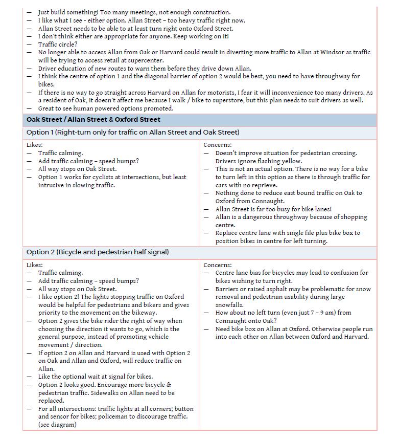
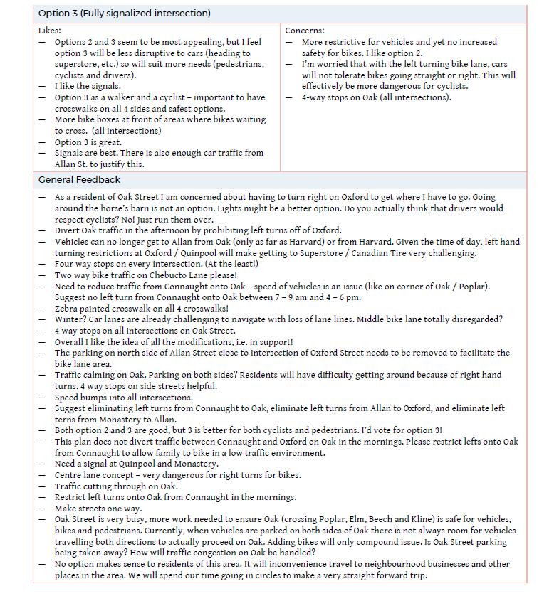
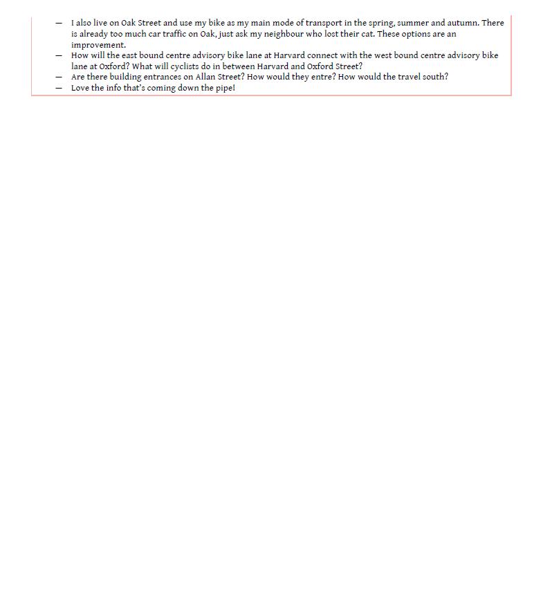
22 Attachment C: Summary of Public Feedback from Public Open House Sessions Nov 8 th
23
24
25
26
27
28
29
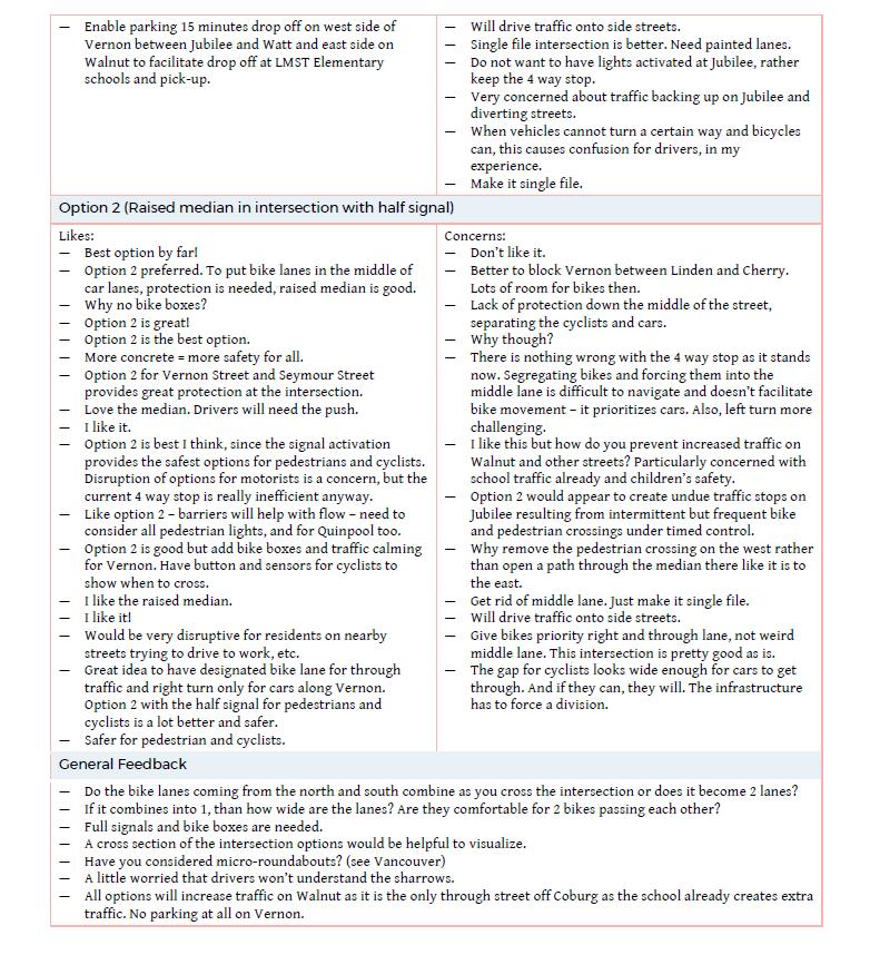
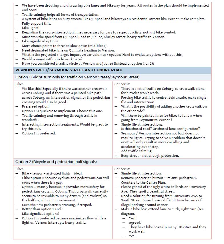
30 Attachment D: Summary of Public Feedback from Online Survey Nov 9th 23 rd (1) Vernon and Quinpool Cycling Considerations More negative comments were received than positive comments about this intersection design Many mentioned concerns about cyclist safety at this intersection o Vehicles forced to turn, may not be looking for cyclists proceeding straight o Should we be encouraging use of this intersection without safe way to proceed through? Many concerned about the centre bike lane o May not be comfortable for all ages and abilities o Prefer to stay near curb o Prefer to have no right turn on red so traffic isn t flowing past on right o Are concerned about transitioning into centre bike lane from curb more conflicts? o Worried about cars not respecting painted lane, blocking lane o Queue of cars at rush hour may prevent clear transition into this lane o Width of lane may be too narrow leading to side swiping or feeling squeezed Some liked the addition of the designated lane o Gives cyclists more visibility on the road / while waiting / leading up to intersection o More clearly demonstrates intention to go straight o Potentially safer for conflicts with left-turning vehicles of Quingate Place Many mentioned that some form of physical protection would be preferable o Minimizes potential conflict with cars waiting at lights o Optimal safety, comfort for all ages and abilities Many mentioned that the green paint and through pavement markings were helpful o More markings are needed to demonstrate / clarify cyclist placement for left/right turns o Preferred markings all the way through the intersection Some mentioned that a painted bike box would be preferable o Approach from curbside, allows cyclist to get in front of traffic and position for straight thru o Maximizes visibility o No right turn on red would be necessary for this Many mentioned that the painted lane would not be respected by vehicles and was confusing o Could lead to more conflicts as vehicles and cyclists navigate through in unpredictable way Some mentioned that it was confusing that vehicles and cyclists had different turning movements through the intersections, petitioned to drive straight through from Vernon Pedestrian Considerations Many respondents believed there weren t any pedestrian gains to the design Some mentioned there should be pedestrian infrastructure improvements such as bump outs o Shorten crossing distance, improve visibility, improve safety o Could investigate pedestrian refuge islands A few mentioned that the turning radii at the corners were too large, should be made tighter o Current situation allows too much speed around corners A few mentioned that there should be a pedestrian and cyclist-only signal phase o Prevents cars turning across crosswalk while walk sign is lit up this is unsafe and many people get anxious waiting and do this, coming very close to pedestrians Vehicular Considerations No change (question not included)
31 (2) Vernon and Jubilee Cycling and Pedestrian Considerations Many respondents thought the raised intersection median was a good idea o Extra measure to prevent vehicles from ignoring turn restrictions and driving through o Has potential to reduce traffic speed on both Vernon Street and Jubilee Road o Acts as pedestrian/cyclist refuge to improve safety o Draws attention to cyclist movement through intersection and establishes priority corridor A few respondents feel that a fully protected and separated bicycle lane is preferred o Completely separate cyclists from vehicles on road to minimize conflicts o May be the only way to achieve full safety and AAA use of this corridor Some respondents noted concerns about the centre bike lane o Does not feel comfortable to have traffic passing on the right side of a cyclist, very exposed o Difficulties and safety concerns with transition away from curb into centre lane o May not be suitable for all ages and abilities Some mentioned that the intersection functions well as it is o Generally single file approach in shared lane o Stop sign and pedestrians create adequate gap for cyclists o Right of way of cyclists is generally respected Some noted that the half signal was too confusing for users of the intersection o Not entirely clear whether cyclists can proceed with any gap or wait for light o Not entirely clear whether pedestrians can proceed with any gap or wait for light o Unusual intersection treatment may catch drivers off guard, lead to unpredictable behaviour Many respondents prefer that stop signs are maintained on Jubilee Road o Can be used as alternative to half signal, achieves same gaps while minimizing delay o This is more familiar as intersection is currently 4-way stop working well o Slows free-flowing traffic speed on Jubilee Road which is a major safety concern for pedestrians Some respondents noted that crosswalks should be maintained across all 4 legs of intersection o Any loss of crosswalk would be a loss for pedestrian priority in this busy area o Half signal could improve safety through protected phase and improve traffic flow o Pedestrian beg button for signal is a step away from pedestrian priority Some mentioned that the raised intersection medians were an issue o Unclear that cyclists could proceed through, potentially dangerous as cars not expecting o Prevents some drivers from making the turns they need to make A few respondents mentioned concerns about winter maintenance o Paths through raised intersection median must be well cleared in the winter o Median can not used for snow piling Vehicular Considerations Many respondents mentioned that the turn restrictions were too prohibitive o Prefer to keep through traffic on Vernon for access to homes, Quinpool, downtown o Route serves to alleviate congestion on Robie, Quinpool, Coburg, Oxford o Leads to major driver inconvenience for very small gains Some noted concerns about increased traffic on adjoining/parallel streets to find alternate route o Can t stop shortcutters, they will just go somewhere else nearby o Speed may increase due to driver aggravation, cause circuitous traffic flow Some mentioned that slowing traffic is a positive thing to improve safety through this area Some mentioned that cars have the capacity to go elsewhere
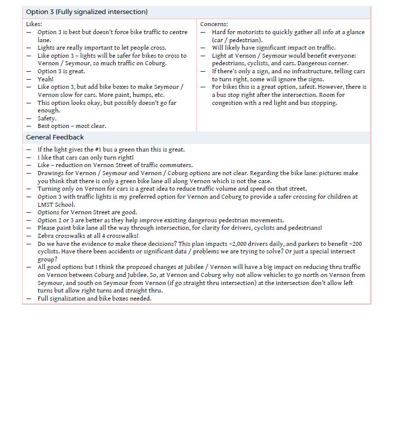
32 o Keeping traffic on nearby arterials is not a bad thing, won t have major impact Some mentioned that designs are meant to establish cyclist priority and they do just that (3) Vernon/Seymour and Coburg Cycling and Pedestrian Considerations Many respondents believe that some form is signalization is good for improving safety at this intersection o Safety for pedestrians, cyclists, and drivers alike o Current offset alignment with high volumes on Coburg makes it difficult to navigate, risky behaviour Many mentioned that full signalization is best o Unmistakeable clarity. People know how to use these o Maintains all four crosswalks for pedestrians, which is important Some noted that making pedestrians and cyclists wait for a light is a negative thing o Causes more delays than in current situation where they can proceed when coast is clear o Loss of active transportation priority over vehicles on this corridor A few respondents mentioned that full signalization is not needed o Volumes on Vernon and Seymour too low to substantiate full signal controlling their traffic flow o Waiting a full signal phase may lead to more congestion on Coburg, other streets nearby A few respondents mentioned concerns with cyclists transitioning into centre bicycle lane o Does not feel comfortable to have traffic passing on the right side of a cyclist, very exposed o Difficulties and safety concerns with transition away from curb into centre lane o May not be suitable for all ages and abilities Some mentioned there may be confusion and safety issues associated with turning restrictions o Possibility of collisions if bicycles and vehicles have different turning restrictions o Drivers may not be expecting or watching for through cyclists A few noted that true safety cannot be achieved until there is full separation of cyclists and cars o Call for fully protected bikeway down this corridor Vehicular Considerations An equal number of generally positive and generally negative comments were received Many respondents noted that the turn restrictions are too prohibitive o Hinders one of the main access routes to Dalhousie University o Major vehicular inconvenience for very small gains not worth it o Driver may not obey these restrictions without a physical barrier Some mentioned that turn restrictions will push more traffic onto nearby roads o Shortcutting down Preston, Henry instead o Keeps traffic on Robie which is already busy and often congested o Increased speed due to driver aggravation may cause safety concerns Some mention that signalization will lead to congestion and travel delays on Coburg Road Some are generally positive about how slight delays may lead to increased safety and flow of this intersection o Creates a better pedestrian environment with addition of crosswalk, protected crossing phase o Established cyclist priority when allowing to proceed straight through intersection o Traffic diversion and reduced speeds will have overall positive impact on neighbourhood
33 (4) Allan/Oak and Oxford Cycling and Pedestrian Considerations A greater number of generally positive comments than generally negative were received about these designs Many respondents believe that some form is signalization is good for improving safety at this intersection o Safety for pedestrians, cyclists, and drivers alike o Current offset alignment with high volumes on Oxford makes it difficult to navigate, risky behaviour Some mentioned that full signalization would be preferable o Unmistakeable clarity. People know how to use these o Maintains all four crosswalks for pedestrians, which is important Some (slightly less) noted that a full signal is not necessary o Not enough volume on Allan or Oak Street to substantiate o Waiting full signal phase will likely lead to more congestion on Oxford Street already full of traffic Some (slightly less) respondents mentioned their desire for cyclists and pedestrians not to have to wait at light o Loses the priority for active transportation through this intersection o Will lead to more travel time delay vs current situation where they can proceed at gap/when safe A few respondents mentioned concerns with cyclists transitioning into centre bicycle lane o Does not feel comfortable to have traffic passing on the right side of a cyclist, very exposed o Difficulties and safety concerns with transition away from curb into centre lane o May not be suitable for all ages and abilities A few noted that true safety cannot be achieved until there is full separation of cyclists and cars o Call for fully protected bikeway down this corridor A few mentioned visibility concerns with proximity of crosswalks to bus stop A few mentioned the need to incorporate pedestrian bump outs o Improve pedestrian visibility o Visually narrow street to slow traffic volumes Vehicular Considerations Many neighbourhood residents have concerns about how the turn restrictions will impact how they enter and exit their neighbourhood, especially at rush hour o Turn restrictions make it difficult to go south from Allan St neighbourhood without either (1) making two difficult left hard turns onto Chebucto then Oxford, or (2) proceeding all the way over to Robie via Chebucto or Welsford o Turn restrictions make it difficult to go north from Oak St neighbourhood o A few wish to keep the possibility of proceeding straight through Oak/Allan to access downtown and Quinpool Road shopping area o Noted that turn restrictions may lead to use of private driveways to turn around in right direction Some are worried about the possible congestion on Oxford that signalization may cause o Must not impact buses, or they have signal priority A few are happy that vehicles will need to slow down through this often speedy segment Some are happy that the designs create a better pedestrian environment and establish cyclist priority Some respondents are concerned that there is undue driver inconvenience for such a small number of cyclists
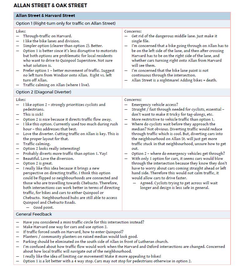
34 (5) Allan and Harvard Cycling and Pedestrian Considerations The majority of comments received about this were positive o Respondents generally liked the novel / radical idea of the diagonal diverter at this location o Have seen it working in other world class cycling cities o Major intervention shows commitment to traffic calming and cyclist priority along corridor Many had questions and we confused about how the diverter worked o Education, pavement markings, and clear signage are needed to ease transition o How do the cyclists transition through the diverter safely? o Drivers may be too caught up trying to understand diverter to watch out for cyclists/pedestrians Many believe that the turn restrictions were good for reducing traffic volume and improving cyclist safety Some respondents mentioned that the intersection works well as its current state as 4-way stop o Prefer wither turn restrictions with 4 way stop, or just 4 way stop with no restrictions o Have not encountered cyclist safety issues here Some respondents want to see physical changes to the intersection but think that a stop sign is necessary for cars turning right off of Harvard Street o Without stop sign, cars will move through this turn too quickly almost like a slip lane o Potentially dangerous for pedestrians crossing in either direction. No incentive to slow and look o Don t understand rationale for removing stop sign that s already working at this spot o Extra stop signs will improve pedestrian and cyclist safety A few mentioned that a protected (or clearly delineated) bike lane leading into the diverter would help o Clarify cyclist movement and smooth transition o More predictable way to introduce new infrastructure o Prevent conflict with cars Very few people mentioned the idea of flipping the diverter to allow right turns off of Allan onto Harvard o Preserves some paths of desired movements through the neighbourhood Vehicular Considerations The majority of comments received about this were negative Many respondents were concerned that that turn restrictions were prohibitive o Limits options for residents of Allan area to get into/out of neighbourhood, especially at rush hour o Neighbourhood connectivity is lost no connection between Allan and Duncan/Lawrence o Limits access to Quinpool Road area, Canadian Tire complex o Makes it more difficult for people generally to drive on the peninsula towards downtown o Forces inconvenient routes, potentially aggravating drivers Some respondents mentioned that the design may impact traffic on nearby streets o Contribute to more traffic and higher speeds on Harvard Street o Funnel vehicles onto Quinpool and Chebucto which are already gridlock at rush hour Some feel that traffic diversion is good and necessary for safety A few feel that cars will adapt over time and that there is capacity elsewhere for drivers to still get around Many felt positive about the trade offs of slight inconvenience for cycling corridor were worth it A few felt there wasn t enough cyclists / need for changes A few noted that most traffic issues are coming from Monastery, and more should be done to alter this intersection instead o Possible full closure at Monastery and Yukon?
35 Attachment E: Summary of Feedback from Neighbouring Residents and Abutters 1a. Vernon Quinpool -- Does this design help meet the objectives of creating a safe, convenient cycling corridor? No 11% 1A. ABUTTERS 6% Maybe 25% Yes 58% 1A. ABUTTERS + NEIGHBOURS 3% No 19% Yes 49% Maybe 29% 1A. ALL RESPONDENTS 2% No 22% Yes 45% Maybe 31%

36 1c. Vernon Quinpool -- Does this design help to make it easier and safer to walk? 1C. ABUTTERS 8% No 28% Yes 42% Maybe 22% 1C. ABUTTERS + NEIGHBOURS 5% Yes 29% No 41% Maybe 25% 1C. ALL RESPONDENTS 3% Yes 23% No 39% Maybe 35%
37 2a. Vernon-Jubilee -- Which of these designs best meet the objectives of creating a safe, convenient cycling corridor? Neither 19% 2A. ABUTTERS 6% Option 1:Turn Restrictions 17% Option 2: Raised Intersection Median 58% Neither 27% 2A. ABUTTERS + NEIGHBOURS 3% Option 1:Turn Restrictions 14% Neither 25% 2A. ALL RESPONDENTS 3% Option 2: Raised Intersection Median 56% Option 1:Turn Restrictions 21% Option 2: Raised Intersection Median 51%
38 2c. Vernon-Jubilee -- Which of these designs makes it easier and safer to walk? 2C. ABUTTERS 6% Option 1:Turn Restrictions 14% Neither 33% 2C. ABUTTERS + NEIGHBOURS 4% Option 2: Raised Intersection Median 47% Option 1:Turn Restrictions 14% Neither 32% Neither 30% 2C. ALL RESPONDENTS 4% Option 2: Raised Intersection Median 50% Option 1:Turn Restrictions 20% Option 2: Raised Intersection Median 46%
39 2d. Vernon-Jubilee -- How concerned are you that this design will impact driving? Very concerned 19% 2D. ABUTTERS 6% Not concerned 50% Somewhat concerned 25% Very concerned 24% 2D. ABUTTERS + NEIGHBOURS 3% Not concerned 47% Somewhat concerned 26% Very concerned 21% 2D. ALL RESPONDENTS 3% Not concerned 53% Somewhat concerned 23%
40 3a. Vernon-Seymour-Coburg -- Which of these designs best meet the objectives of creating a safe, convenient cycling corridor? None of the above 11% 3A. ABUTTERS 8% Option 1: Turn Restrictions 20% Option 3: Full Signalization 39% Option 2: Pedestrian and Cyclist Half Signal 22% 3A. ABUTTERS + NEIGHBOURS None of the above 13% 5% Option 1: Turn Restrictions 12% Option 3: Full Signalization 44% Option 2: Pedestrian and Cyclist Half Signal 26% None of the above 18% Option 3: Full Signalization 42% 3A. ALL RESPONDENTS 5% Option 1: Turn Restrictions 11% Option 2: Pedestrian and Cyclist Half Signal 24%

41 3c. Vernon-Seymour-Coburg -- Which of these designs makes it safer and easier to walk? 3C. ABUTTERS 11% Option 1: Turn Restrictions 8% None of the above 14% Option 2: Pedestrian and Cyclist Half Signal 22% Option 3: Full Signalization 45% None of the above 12% 3C. ABUTTERS + NEIGHBOURS 7% Option 1: Turn Restrictions 6% Option 3: Full Signalization 51% Option 2: Pedestrian and Cyclist Half Signal 24% None of the above 15% 3C. ALL RESPONDENTS 6% Option 1: Turn Restrictions 8% Option 2: Pedestrian and Cyclist Half Signal 23% Option 3: Full Signalization 48%
42 3e. Vernon-Seymour-Coburg -- How concerned are you that this design will impact driving? Very concerned 17% 3E. ABUTTERS 8% Not concerned 47% Somewhat concerned 28% Very concerned 21% 3E. ABUTTERS + NEIGHBOURS 5% Not concerned 51% Somewhat concerned 23% Very concerned 20% 3E. ALL RESPONDENTS 5% Not concerned 52% Somewhat concerned 23%
43 4a. Allan-Oak-Oxford -- Which of these designs best meet the objectives of creating a safe, convenient cycling corridor? 17% 4A. ABUTTERS Option 1: Turn Restrictions 14% None of the above 14% Option 2: Pedestrian and Cyclist Half Signal 25% Option 3: Full Signalization 30% None of the above 17% Option 3: Full Signalization 33% 4A. ABUTTERS + NEIGHBOURS 10% Option 1: Turn Restrictions 11% Option 2: Pedestrian and Cyclist Half Signal 29% None of the above 17% 4A. ALL RESPONDENTS 9% Option 1: Turn Restrictions 9% Option 2: Pedestrian and Cyclist Half Signal 31% Option 3: Full Signalization 34%
44 4c. Allan-Oak-Oxford -- Which of these designs makes it easier and safer to walk? None of the above 11% 19% 4C. ABUTTERS Option 1: Turn Restrictions 11% Option 2: Pedestrian and Cyclist Half Signal 14% Option 3: Full Signalization 45% None of the above 14% 4C. ABUTTERS + NEIGHBOURS 11% Option 1: Turn Restrictions 9% Option 2: Pedestrian and Cyclist Half Signal 24% Option 3: Full Signalization 42% None of the above 15% Option 3: Full Signalization 40% 4C. ALL RESPONDENTS 10% Option 1: Turn Restrictions 7% Option 2: Pedestrian and Cyclist Half Signal 28%
45 4e. Allan-Oak-Oxford -- How concerned are you that this design will impact driving? 4E. ABUTTERS 19% Not concerned 31% Very concerned 22% Somewhat concerned 28% 4E. ABUTTERS + NEIGHBOURS 11% Very concerned 27% Not concerned 38% 4E. ALL RESPONDENTS 9% Somewhat concerned 24% Very concerned 21% Not concerned 46% Somewhat concerned 24%
46 5a. Allan-Harvard -- Which of these designs best meet the objectives of creating a safe, convenient cycling corridor? 22% 5A. ABUTTERS Option 1: Raised Intersection Median 14% Neither 14% Option 2: Diagonal Diverter 50% Neither 23% 5A. ABUTTERS + NEIGHBOURS 14% Option 1: Raised Intersection Median 28% Option 2: Diagonal Diverter 35% Neither 22% 5A. ALL RESPONDENTS 10% Option 1: Raised Intersection Median 32% Option 2: Diagonal Diverter 36%


47 5c. Allan-Harvard -- Which of these designs makes it easier and safer to walk? 30% 5C. ABUTTERS Option 1: Raised Intersection Median 17% Neither 14% Option 2: Diagonal Diverter 39% 5C. ABUTTERS + NEIGHBOURS 18% Option 1: Raised Intersection Median 23% Neither 27% Option 2: Diagonal Diverter 32% 5C. ALL RESPONDENTS 12% Option 1: Raised Intersection Median 26% Neither 28% Option 2: Diagonal Diverter 34%
Item No Halifax Regional Council January 16, 2018 January 30, 2018
 P.O. Box 1749 Halifax, Nova Scotia B3J 3A5 Canada Item No. 9.2.1 Halifax Regional Council January 16, 2018 January 30, 2018 TO: Mayor Savage and Members of Halifax Regional Council Original Signed SUBMITTED
Chair and Members of Transportation Standing Committee. Bruce Zvaniga, P.Eng., Director, Transportation and Public Works
 P.O. Box 1749 Halifax, Nova Scotia B3J 3A5 Canada Item No. 12.1.1 Transportation Standing Committee December 7, 2017 TO: Chair and Members of Transportation Standing Committee SUBMITTED BY: ORIGINAL SIGNED
TRAFFIC CALMING GUIDE FOR TORONTO CITY OF TORONTO TRANSPORTATION SERVICES DIVISION
 TRAFFIC CALMING GUIDE FOR TORONTO CITY OF TORONTO TRANSPORTATION SERVICES DIVISION CITY OF TORONTO TRANSPORTATION SERVICES DIVISION 2016 TRAFFIC CALMING GUIDE FOR TORONTO TABLE OF CONTENTS Introduction
Item No Halifax Regional Council March 6, 2018
 P.O. Box 1749 Halifax, Nova Scotia B3J 3A5 Canada Item No. 14.3.2 Halifax Regional Council March 6, 2018 TO: SUBMITTED BY: Mayor Savage and Members of Halifax Regional Council Original Signed Councillor
CITY OF SAINT JOHN TRAFFIC CALMING POLICY
 CITY OF SAINT JOHN TRAFFIC CALMING POLICY VERSION: 1.0 April 10, 2012 Pedestrians, Cyclists and Motorists Sharing Street Spaces CONTENTS INTRODUCTION... 3 POLICY GOAL... 3 POLICY OBJECTIVES... 3 GUIDING
Almon Street Bike Lane Planning
 Almon Street Bike Lane Planning Public Engagement Session Maritime Room, Halifax Forum May 3, 2017 Agenda 6:30 pm 7:00 pm Browse display boards, talk to staff. 7:00 pm 7:30 pm Presentation 7:30 pm 7:40
Item No. 8.1 Transportation Standing Committee June 28, 2018
 P.O. Box 1749 Halifax, Nova Scotia B3J 3A5 Canada Item No. 8.1 Transportation Standing Committee June 28, 2018 TO: Chair and Members of Transportation Standing Committee Original Signed SUBMITTED BY: Bruce
Tonight is for you. Learn everything you can. Share all your ideas.
 Strathcona Neighbourhood Renewal Draft Concept Design Tonight is for you. Learn everything you can. Share all your ideas. What is Neighbourhood Renewal? Creating a design with you for your neighbourhood.
P.O. Box 1749 Halifax, Nova Scotia B3J 3A5 Canada Item No. Halifax Regional Council January 16, 2017
 P.O. Box 1749 Halifax, Nova Scotia B3J 3A5 Canada Item No. Halifax Regional Council January 16, 2017 TO: Mayor Savage and Members of Halifax Regional Council SUBMITTED BY: Jacques Dubé, Chief Administrative
P.O. Box 1749 Halifax, Nova Scotia B3J 3A5 Canada Item No Halifax Regional Council September 18, 2018
 P.O. Box 1749 Halifax, Nova Scotia B3J 3A5 Canada Item No. 14.1.6 Halifax Regional Council September 18, 2018 TO: SUBMITTED BY: Mayor Savage and Members of Halifax Regional Council Original Signed Jacques
Broad Street Bicycle Boulevard Design Guidelines
 Broad Street Bicycle Boulevard Design Guidelines Building from the strategies introduced in the 2013 Bicycle Transportation Plan and community input received thus far, City Transportation Staff have identified
CITY OF COCOA BEACH 2025 COMPREHENSIVE PLAN. Section VIII Mobility Element Goals, Objectives, and Policies
 CITY OF COCOA BEACH 2025 COMPREHENSIVE PLAN Section VIII Mobility Element Goals, Objectives, and Policies Adopted August 6, 2015 by Ordinance No. 1591 VIII MOBILITY ELEMENT Table of Contents Page Number
P.O. Box 1749 Halifax, Nova Scotia B3J 3A5 Canada Item No Halifax Regional Council December 12, 2017
 P.O. Box 1749 Halifax, Nova Scotia B3J 3A5 Canada Item No. 14.1.2 Halifax Regional Council December 12, 2017 TO: Mayor Savage and Members of Halifax Regional Council SUBMITTED BY: Jacques Dubé, Chief Administrative
CITY OF OTTAWA ROADWAY MODIFICATION APPROVAL UNDER DELEGATED AUTHORITY
 RMA-2015-ATM-038 CITY OF OTTAWA ROADWAY MODIFICATION APPROVAL UNDER DELEGATED AUTHORITY DATE: April 22, 2015 SUBJECT Approval of Roadway Modifications Recommended through an Area Traffic Management Study
CLOSED. The draft concept design has been broken down into 5 categories for the purpose of this survey:
 Old Strathcona s neighbourhood renewal process is now at the draft concept design phase. Over the last several months, the city has been gathering local knowledge and resident input that has been used
REPORT. Engineering and Construction Department
 REPORT COMMUNITY SERVICES COMMITTEE MEETING DATE: JUNE 11, 2013 FROM: Engineering and Construction Department DATE: May 24, 2013 SUBJECT: Great Lakes Boulevard Mini Roundabout LOCATION: Great Lakes Boulevard
University of Victoria Campus Cycling Plan Terms of Reference. 1.0 Project Description
 University of Victoria Campus Cycling Plan Terms of Reference 1.0 Project Description The Campus Cycling Plan, a first for the University, will provide a comprehensive and coordinated approach to support
POLICY: TRAFFIC CALMING
 2006 MAY REFERENCE: COUNCIL APPROVED BY COUNCIL MAY 23, 2006 CITY OPERATIONS - NO. 608 POLICY: TRAFFIC CALMING A. All requests for traffic calming within the City shall be considered in accordance with
Active Transportation Infrastructure Investment A Business Case
 Active Transportation Infrastructure Investment A Business Case In 2016, the Real Estate Foundation awarded the Capital Regional District a $50,000 grant for Shifting Gears: Land Use Change through Active
Improving Cyclist Safety at the Dundas Street West and Sterling Road Intersection
 STAFF REPORT ACTION REQUIRED Improving Cyclist Safety at the Dundas Street West and Sterling Road Intersection Date: August 17, 2012 To: From: Wards: Reference Number: Public Works and Infrastructure Committee
Downey Road. Transportation Improvement Study
 Downey Road Transportation Improvement Study Workshop 2 Participant Handbook Workshop 1 May 18 and 19, 2016 Workshop 2 June 23 and 28, 2016 Prepared By: City of Guelph Paradigm Transportation Solutions
City of Charlottesville Bicycle and Pedestrian Master Plan Update
 City of Charlottesville Bicycle and Pedestrian Master Plan Update September 17, 2014 I. Welcome and meeting overview II. Project status update III. Network overview IV. Break-out groups Pedestrian Network
NEIGHBOURHOOD TRAFFIC COMMITTEE POLICY AND PROCEDURE
 The City of Vaughan 2141 Major Mackenzie Drive Vaughan, Ontario Canada L6A 1T1 Tel (905) 832-2281 NEIGHBOURHOOD TRAFFIC COMMITTEE POLICY AND PROCEDURE REVISED JUNE 2010 APPLICABILITY The Neighbourhood
Governance and Priorities Committee Report For the July 2, 2015 Meeting
 CITY OF VICTORIA For the July 2, 2015 Meeting To: Governance and Priorities Committee Date: From: Subject: Brad Dellebuur, A/Assistant Director, Transportation and Parking Services Executive Summary The
Exhibit 1 PLANNING COMMISSION AGENDA ITEM
 Exhibit 1 PLANNING COMMISSION AGENDA ITEM Project Name: Grand Junction Circulation Plan Grand Junction Complete Streets Policy Applicant: City of Grand Junction Representative: David Thornton Address:
Saskatchewan Drive Roadway Rehabilitation and Shared-Use Path Widening
 Saskatchewan Drive Roadway Rehabilitation and Shared-Use Path Widening We are here today to present the draft plan for the Saskatchewan Drive Roadway Rehabilitation and Shared-Use Path Widening project
Kelowna On the Move. Pedestrian and Bicycle Master Plan
 Kelowna On the Move Pedestrian and Bicycle Master Plan Executive Summary April 2016 Purpose of the Plan The Pedestrian and Bicycle Master Plan identifies infrastructure, planning, and policy requirements
TO: Board Members Vancouver Park Board FROM: General Manager Parks and Recreation SUBJECT: Seaside Greenway Improvements
 Date: October 1, 2013 TO: Board Members Vancouver Park Board FROM: General Manager Parks and Recreation SUBJECT: Seaside Greenway Improvements RECOMMENDATION A. THAT the Board approve the new bike paths
Bicycling Routes on Provincial Roads Policy
 Bicycling Routes on Provincial Roads Policy Policy Statement Rationale To support bicycling in Nova Scotia, the Department of Transportation and Infrastructure Renewal (TIR) may designate some portions
Road Alterations - Wellington Street East, Church Street, and Front Street Intersection
 REPORT FOR ACTION Road Alterations - Wellington Street, Church Street, and Front Street Intersection Date: November 1, 2016 To: Toronto and York Community Council From: Director, Public Realm Section,
CITY OF VANCOUVER ADMINISTRATIVE REPORT
 CITY OF VANCOUVER ADMINISTRATIVE REPORT Report Date: May 31, 2007 Author: Paul Storer Phone No.: 604.873.7693 RTS No.: 06348 VanRIMS No.: 13-5000-20 Meeting Date: June 12, 2007 TO: FROM: SUBJECT: Standing
FOCUS AREA 1 - Alberta Avenue Pocket Park 3 (121 Ave and 92 St)
") FOCUS AREA 1 - Alberta Avenue Pocket Park 3 (121 Ave and 92 St) New benches Plant evergreen trees Widen existing sidewalk from 1.5m to 1.8m Marked crosswalk 1.8m wide sidewalk Add pedestrian oriented lights
FOCUS AREA 1 - Alberta Avenue Pocket Park 3 (121 Ave and 92 St) New benches Plant evergreen trees Widen existing sidewalk from 1.5m to 1.8m Marked crosswalk 1.8m wide sidewalk Add pedestrian oriented lights
Major Bike Routes 102 Avenue Workshop April 21, 2015
 Major Bike Routes 102 Avenue Workshop April 21, 2015 Our Purpose Today Provide context on how Major Bike Routes fit into Edmonton s future Share information on what we heard in our last phase, and how
Traffic Calming Policy
 Page 22 of Report TS-1-13 Development and Infrastructure Division Transportation Services Department Approved by: City Council on February 19, 2013 Report Number: TS-1-13 Effective: February 20, 2013 Amended:
a) receiving of legal advice subject to solicitor client privilege and labour relations regarding contract negotiations
 receiving of legal advice subject to solicitor client privilege and labour relations regarding contract negotiations") Regional Municipality of Waterloo Planning and Works Committee Agenda Tuesday, April 4, 2017 9:30 a.m. (Following Closed Session) Regional Council Chamber 150 Frederick Street, Kitchener Media Release:
Regional Municipality of Waterloo Planning and Works Committee Agenda Tuesday, April 4, 2017 9:30 a.m. (Following Closed Session) Regional Council Chamber 150 Frederick Street, Kitchener Media Release:
CITY OF HAMILTON PLANNING AND ECONOMIC DEVELOPMENT DEPARTMENT Transportation Planning and Parking Division
 CITY OF HAMILTON PLANNING AND ECONOMIC DEVELOPMENT DEPARTMENT Transportation Planning and Parking Division TO: Chair and Members Public Works Committee COMMITTEE DATE: June 18, 2018 SUBJECT/REPORT NO:
Traffic Calming Policy
 Article I. Purpose and Goal. The purpose of this policy is to establish criteria and procedures the City will use to evaluate requests for, and if appropriate, implement traffic calming measures. Neighborhood
Living Streets Policy
 Living Streets Policy Introduction Living streets balance the needs of motorists, bicyclists, pedestrians and transit riders in ways that promote safety and convenience, enhance community identity, create
Dr. M.L. King, Jr. Street North Complete Streets Resurfacing Opportunities HOUSING, LAND USE, AND TRANSPORTATION COMMITTEE MARCH 22, 2018
 Dr. M.L. King, Jr. Street North Complete Streets Resurfacing Opportunities HOUSING, LAND USE, AND TRANSPORTATION COMMITTEE MARCH 22, 2018 What s Happening The City plans to mill and resurface Dr. M.L.
TOWN OF PORTLAND, CONNECTICUT COMPLETE STREETS POLICY
 TOWN OF PORTLAND, CONNECTICUT COMPLETE STREETS POLICY I. VISION, GOALS & PRINCIPLES VISION To improve the streets of Portland making them safer and more accessible for all users including pedestrians,
Item No Halifax Regional Council July 19, 2016
 P.O. Box 1749 Halifax, Nova Scotia B3J 3A5 Canada Item No. 14.5.3 Halifax Regional Council July 19, 2016 TO: Mayor Savage and Members of Halifax Regional Council Original Signed SUBMITTED BY: Councillor
Public Information Centre
 WELCOME Public Information Centre Father Tobin Road Lougheed Middle School - Library Wednesday November 7, 2012 7:00 p.m.to 9:00 p.m. Please sign in Neighbourhood Traffic Calming Guide Background The City
Glebe Neighbourhood Cycling Plan
 Glebe Neighbourhood Cycling Plan Summary of Public Comments received after June 5 th Public Information Session Comment STUDY NETWORK CS9, CS8, E, E0 CS4, E CS4 CS8 E Suggestions for alternate cycling
Bicycle Friendly Streets
 Bicycle Friendly Streets 4.1 Guiding Principle and Objectives Bicycles are recognized as vehicles under the Highway Traffic Act, and as such, should be afforded the same consideration as motor vehicles
Bikeway action plan. Bicycle Friendly Community Workshop March 5, 2007 Rochester, MN
 Bikeway action plan Summary The was held on March 5, 2007 at the Rochester Mayo Civic Center. The workshop was hosted by Rochester-Olmsted County Planning Department in collaboration with the League of
Dowling/Beaty Cycling Route
 Public Meeting #2 Dowling/Beaty Cycling Route May 17, 2017 6:00 p.m. 8:00 p.m. Parkdale Public Library - Auditorium 1303 Queen Street West How to Participate Share your questions, ideas and concerns We
AGENDA ITEM G-2 Public Works
 AGENDA ITEM G-2 Public Works STAFF REPORT City Council Meeting Date: 12/6/2016 Staff Report Number: 16-214-CC Regular Business: Approve the Oak Grove University Crane Bike Improvement Concept Plan, authorize
Item No. 8.1 Transportation Standing Committee February 1, 2018 February 22, 2018
 P.O. Box 1749 Halifax, Nova Scotia B3J 3A5 Canada TO: SUBMITTED BY: Chair and Members of Transportation Standing Committee ORIGINAL SIGNED Kelly Denty, Acting Director: Planning & Development Item No.
Active Transportation Facility Glossary
 Active Transportation Facility Glossary This document defines different active transportation facilities and suggests appropriate corridor types. Click on a facility type to jump to its definition. Bike
MAG Town of Cave Creek Bike Study Task 6 Executive Summary and Regional Significance Report
 Page 1 MAG Town of Cave Creek Bike Study Task 6 Executive Summary and Regional Significance Report August 1, 2012 MAG Project #481 Page 2 Task 6 Executive Summary and Regional Significance Report Introduction
Item No. 14 Town of Atherton
 Item No. 14 Town of Atherton CITY COUNCIL STAFF REPORT CONSENT AGENDA TO: THROUGH: FROM: HONORABLE MAYOR AND CITY COUNCIL GEORGE RODERICKS, CITY MANAGER MICHAEL KASHIWAGI, COMMUNITY SERVICES DIRECTOR MARTY
CITY OF WEST KELOWNA COUNCIL POLICY MANUAL
 CITY OF WEST KELOWNA COUNCIL POLICY MANUAL Page 1 of 7 DEPARTMENT: Engineering Services SUBJECT: Traffic Calming Policy (Revised June 6, 2017) Policy Statement: The provision of traffic calming measures
Classification Criteria
 SCHEDULE D TO RECOMMENDED OFFICIAL PLAN AMENDMENT NO. 40 SCHEDULE C-4 Road Criteria Criteria Traffic Service Objective Land Service/Access Typical Daily Traffic Volume Flow characteristics Travel Speed
Public Works and Infrastructure Committee. General Manager, Transportation Services
 STAFF REPORT ACTION REQUIRED Extending the Bay Street Bicycle Lanes Date: May 16, 2013 To: From: Public Works and Infrastructure Committee General Manager, Transportation Services Wards: Toronto Centre
THE CORPORATION OF THE CITY OF WINDSOR POLICY
 THE CORPORATION OF THE CITY OF WINDSOR POLICY Service Area: Office of the City Engineer Policy No.: Department: Traffic Operations Approval Date: September 21, 2015 Division: Transportation Planning Approved
Committee of the Whole Report For the Meeting of October 6, 2016
 CITY OF VICTORIA For the Meeting of October 6, 2016 To: Committee of the Whole Date: September 29,2016 From: Subject: Fraser Work, Director of Engineering and Public Works RECOMMENDATION That Council direct
Byron Avenue. Public Meeting. Thursday June 16, Traffic Calming Design Sherbourne Road to Island Park Drive
 Byron Avenue Traffic Calming Design Sherbourne Road to Island Park Drive Public Meeting Thursday June 16, 2016 Our Lady of Fatima Parish 153 Woodroffe Avenue 6 9pm 1 Project Summary Area Projects Background
Complete Streets Process and Case Study: Taft / McMillian Two-Way Street Conversion Cincinnati, Ohio. Traffic Engineering Workshop June 4, 2014
 Complete Streets Process and Case Study: Taft / McMillian Two-Way Street Conversion Cincinnati, Ohio Traffic Engineering Workshop June 4, 2014 Complete Streets Streets that enable safe access for users
Recommended Improvements - Ruby/Banning Neighbourhood Greenway
 MORE PEOPLE BIKING MORE OFTEN Ruby and Banning Streets have the potential to be an important part of the City of Winnipeg s bicycle network, with direct, low stress access to a community centre, multiple
Bicycle Facilities Planning
 Bicycle Facilities Planning Overview Types of Cyclists Purpose for Riding Types of Facilities Bike Lanes Bicycle Boulevards Cycle Tracks Intersections Signals Signing and Marking Discussion Types of Bicyclists
REGIONAL BICYCLE AND PEDESTRIAN DESIGN GUIDELINES
 REGIONAL BICYCLE AND PEDESTRIAN DESIGN GUIDELINES November 16, 2011 Deb Humphreys North Central Texas Council of Governments Bicycle and Pedestrian Advisory Committee Snapshot of the Guide 1. Introduction
Traffic Calming Rosemount Avenue, between Ralph Street and Queenslea Avenue
 STAFF REPT ACTION REQUIRED Traffic Calming Rosemount Avenue, between Ralph Street and Queenslea Avenue Date: April 20, 2016 To: From: Wards: Report Number: Etobicoke York Community Council Director, Transportation
Coquitlam Cross-town Bike Route Improving Bicycle Facilities in a Mature Suburban Environment
 Coquitlam Cross-town Bike Route Improving Bicycle Facilities in a Mature Suburban Environment Sarah Rocchi, Vice-President, Projects, Opus International Consultants (Main Presenter) Catherine Mohoruk,
Toronto and East York Community Council. Director, Transportation Services, Toronto and East York District
 No Turn on Red Regulations STAFF REPORT ACTION REQUIRED Date: June 1, 2010 To: From: Toronto and East York Community Council Director, Transportation Services, Toronto and East York District Wards: Trinity
Town of Mooresville, North Carolina Neighborhood Traffic Calming and Control Device Policy
 Town of Mooresville, North Carolina Neighborhood Traffic Calming and Control Device Policy Adopted January 6, 2014 Town of Mooresville Development Services Department TOWN OF MOORESVILLE NEIGHBORHOOD TRAFFIC
HARRISON STREET/OAKLAND AVENUE COMMUNITY TRANSPORTATION PLAN
 HARRISON STREET/OAKLAND AVENUE Community Workshop #4: Draft Plan Review December 3, 2009 D E S I G N, C O M M U N I T Y & E N V I R O N M E N T INTRODUCTIONS Key Project Staff: Alisa Shen, Project Manager,
2014/2015 BIKE ROUTE PLAN 83 AVENUE PROTECTED BIKE LANE
 About the Project 2014/2015 BIKE ROUTE PLAN The City of Edmonton is planning a major bike route on the south side of Edmonton. This bike route is one part of a plan to provide citizens with transportation
WELCOME Public Information Centre
 WELCOME Public Information Centre Fernforest Drive Brampton Soccer Centre Community Room #2 Tuesday January 19, 2016 6:30 p.m.to 9:00 p.m. Please sign in Neighbourhood Traffic Calming Guide Background
City of Elizabeth City Neighborhood Traffic Calming Policy and Guidelines
 City of Elizabeth City Neighborhood Traffic Calming Policy and Guidelines I. Purpose: The City of Elizabeth City is committed to ensure the overall safety and livability of residential neighborhoods. One
Broad Street Bicycle Boulevard City Council Study Session Summary
 Broad Street Bicycle Boulevard City Council Study Session Summary Overview: On August 15 th, 2017, a City Council Study Session was held to invite community input and request City Council guidance on a
Pattullo Bridge Replacement Project Community Connections Phase 2 Consultation. Appendix 3: Open House Display Boards
 Replacement Project Community Connections Phase 2 Consultation Appendix 3: Open House Display Boards November 2016 Welcome! Welcome to the Replacement Project Public Open House We Want to Hear from You
P.O. Box 1749 Halifax, Nova Scotia B3J 3A5 Canada Item No Halifax Regional Council May 9, 2017
 P.O. Box 1749 Halifax, Nova Scotia B3J 3A5 Canada Item No. 14.1.4 Halifax Regional Council May 9, 2017 TO: Mayor Savage and Members of Halifax Regional Council SUBMITTED BY: Brad Anguish, A/Chief Administrative
Public Works Committee Meeting Richard E. Mastrangelo Council Chamber November 20, 2017
 Public Works Committee Meeting Richard E. Mastrangelo Council Chamber November 20, 2017 Purpose of Meeting Why are we here? Project Recap/Updates Project Limits/Segments Road Diet Concept Lessons Learned
Item No Transportation Standing Committee June 23, 2016
 P.O. Box 1749 Halifax, Nova Scotia B3J 3A5 Canada Item No. 12.1.2 Transportation Standing Committee June 23, 2016 TO: SUBMITTED BY: Chair and Members of Transportation Standing Committee Original Signed
2014/2015 BIKE ROUTE PLAN 83 AVENUE PROTECTED BIKE LANE
 About the Project The City of Edmonton is planning a major bike route on the southside of Edmonton. The Strathcona Bike Route will connect the communities of Strathcona, Garneau and the University area,
REPORT District of Maple Ridge
 REPORT District of Maple Ridge Traffic Calming Policy This report is prepared for the sole use of the District of Maple Ridge. No representations of any kind are made by Urban Systems Ltd. or its employees
County of Greenville South Carolina. Traffic Calming Program Neighborhood Traffic Education Program and Speed Hump Program
 County of Greenville South Carolina Traffic Calming Program Neighborhood Traffic Education Program and Speed Hump Program (rev) August 2008 I. PURPOSE The potential negative impacts from vehicular traffic
City of Memphis On-Street Parking Modification Guidelines
 City of Memphis Effective Date: December 1, 2013 Bicycle/Pedestrian Program 125 N. Main Street Memphis, TN 38103 (901) 576-6710 www.bikepedmemphis.com City of Memphis Executive Summary It is current practice
Chapter 2: Standards for Access, Non-Motorized, and Transit
 Standards for Access, Non-Motorized, and Transit Chapter 2: Standards for Access, Non-Motorized, and Transit The Washtenaw County Access Management Plan was developed based on the analysis of existing
Minor Amendments to the Street and Traffic By-law 2849 and Skateboards in Protected Bike Lanes
 ADMINISTRATIVE REPORT Report Date: October 31, 2017 Contact: Lon LaClaire Contact No.: 604.873.7336 RTS No.: 12241 VanRIMS No.: 08-2000-20 Meeting Date: November 15, 2017 TO: FROM: SUBJECT: Standing Committee
East Burke Transportation, Safety and Capacity Improvements
 East Burke Transportation, Safety and Capacity Improvements The purpose of this project is to increase mobility and improve safety for pedestrians, cyclists, and motor vehicles along VT Route 114 in the
LANCASTER CITY BICYCLE NETWORK
 LANCASTER CITY BICYCLE NETWORK Downtown Merchants Meeting Wednesday, July 19, 2017 http://www.lancasteratp. DOWNTOWN WALKABILITY ANALYSIS What changes can be made, in the least amount of time, and for
APPENDIX 2 LAKESHORE ROAD TRANSPORTATION REVIEW STUDY EXECUTIVE SUMMARY
 APPENDIX 2 LAKESHORE ROAD TRANSPORTATION REVIEW STUDY EXECUTIVE SUMMARY Appendix 2 City of Mississauga Lakeshore Road FINAL REPORT Transportation Review Study December 2010 EXECUTIVE SUMMARY Study Purpose
CONNECTIVITY PLAN. Adopted December 5, 2017 City of Virginia Beach
 CONNECTIVITY PLAN Adopted December 5, 2017 City of Virginia Beach CONTENTS 1.0 Background & Purpose... 2 2.0 Existing Inventory & Analysis... 3 ViBe District Existing Walking Conditions... 4 3.0 ViBe District
Proposed Bridge Street East Bicycle Lanes Public Open House Thursday, April 27, 2017
 WELCOME Proposed Bridge Street East Bicycle Lanes Public Open House Thursday, April 27, 2017 Purpose of the Open House The purpose of this Open House is to gain public input on the bicycle lanes proposed
Pedestrian Crosswalk Audit
 1200, Scotia Place, Tower 1 10060 Jasper Avenue Edmonton, Alberta T5J 3R8 edmonton.ca/auditor Pedestrian Crosswalk Audit June 19, 2017 The conducted this project in accordance with the International Standards
102 Avenue Corridor Review
 February 26, 2015 102 Avenue Corridor Review Transportation Association of Canada Road Safety Engineering Award Submission for the City of Edmonton Introduction Transportation Association of Canada Road
MEMORANDUM. Earl Haugen and UND Transportation and Traffic Coordination Committee
 SRF No. 7766 MEMORANDUM TO: FROM: Earl Haugen and UND Transportation and Traffic Coordination Committee Rick Lane, P.E. DATE: November 26, 2013 SUBJECT: UNIVERSITY AVE REVIEW Our review of the University
Proposed. City of Grand Junction Complete Streets Policy. Exhibit 10
 Proposed City of Grand Junction Complete Streets Policy Exhibit 10 1 City of Grand Junction Complete Streets Policy Vision: The Complete Streets Vision is to develop a safe, efficient, and reliable travel
Uptown West Neighbourhood Transportation Study
 Uptown West Neighbourhood Transportation Study Public Open House #2 Information for Review As we move towards the second public open house on May 6, 2014, information on the alternative solutions that
Shifting Gears for a Healthier City
 Shifting Gears for a Healthier City Mississauga s Cycling Master Plan is an ambitious strategy that sets out to transform Mississauga into a city that is conducive to cycling for daily transportation needs.
Appendix C. TRAFFIC CALMING PROGRAM TOOLBOX
 Appendix C. TRAFFIC CALMING PROGRAM TOOLBOX PHASE I...2 Do Not Enter Sign...3 One-Way Sign...4 Turn Prohibition...5 Pavement Markings...6 Speed Monitoring Trailer...7 Neighborhood Speed Watch...8 Police
o n - m o t o r i z e d transportation is an overlooked element that can greatly enhance the overall quality of life for the community s residents.
 N o n - m o t o r i z e d transportation is an overlooked element that can greatly enhance the overall quality of life for the community s residents. 84 Transportation CHAPTER 11 INTRODUCTION Transportation
We want to hear from you!
 Welcome Improvement Program We want to hear from you! As part of the Transportation 2040 plan, the City is implementing an ongoing cycling spot improvement program for existing bicycle routes. We are currently
Corporate Report. Recommendation
 Deferred by General Committee, August 25, 2014, Item 3.4 Corporate Report Report from Transportation and Environmental Services, Operations Date of Report: August 7, 2014 Date of Meeting: September 8,
NM-POLICY 1: Improve service levels, participation, and options for non-motorized transportation modes throughout the County.
 Transportation PRINCE WILLIAM COUNTY 2008 COMPREHENSIVE PLAN NON-MOTORIZED PLAN CONTENTS Goals, Policies, and Action Strategies Table 4 (Bike Facility Classifications and Descriptions) Table 5 (Bike Facility
Traffic Calming St. Clarens Avenue between Brandon Avenue and Davenport Road
 STAFF REPT ACTION REQUIRED Traffic Calming St. Clarens Avenue between Brandon Avenue and Davenport Road Date: February 2, 2012 To: From: Wards: Reference Number: Etobicoke York Community Council Acting
SAN FRANCISCO MUNICIPAL TRANSPORTATION AGENCY
 THIS PRINT COVERS CALENDAR ITEM NO. : 11 DIVISION: Sustainable Streets BRIEF DESCRIPTION: SAN FRANCISCO MUNICIPAL TRANSPORTATION AGENCY Approving traffic modifications on Twin Peaks Boulevard between Christmas
Safe Streets. City of Lake Forest Park. March 21, 2017
 Safe Streets City of Lake Forest Park March 21, 2017 1 01 WELCOME 2 Agenda WELCOME WHAT IS THIS PROJECT? CONTEXT DRAFT CITYWIDE PROJECTS EXERCISE INTRODUCTION 3 02 WHAT IS THIS PROJECT? 4 WHAT IS THIS
Welcome. If you have any questions or comments on the project, please contact:
 Welcome This drop-in public open house is intended to provide information about the Bay Street bike lanes project. This project proposes a dedicated cycling facility along Bay Street between Aberdeen Avenue