Downtown Investment Authority JULY 19 TH, 2017
|
|
|
- Sheena Tabitha Copeland
- 5 years ago
- Views:
Transcription

1 Downtown Investment Authority JULY 19 TH, 2017


2 COMMUNITY SUPPORT AND LONG-TERM PLANS Redevelopment Goal No. 1 Reinforce Downtown as the City s unique epicenter for business, history, culture, education, and entertainment. Redevelopment Goal No. 4 Improve walkability/bikeability and connectivity to adjacent neighborhoods and the St. Johns River while creating highly walkable nodes. Redevelopment Goal No. 7 Use planning and economic development policies to promote design for healthy living.

.")
3 Two-way Street Conversion & Liberty Street Improvements are both identified as priorities within the CRA Plan for Downtown (Ord E). CRA Plan is the result of over 40 public meetings.
4
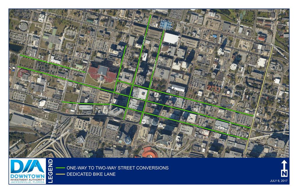
5 TWO-WAY STREET CONVERSION The CRA Plan identifies multiple streets for conversion from one-way into two-way streets. Existing Downtown oneway street patterns promote faster speeds and reduce wayfinding and traffic dispersion for motorists and lead to confusion and circuitous travel to destinations and attractions. For the casual visitor to Downtown Jacksonville, the one-way street grid often presents a confusing circulation pattern and a frustration at the inability to find a specific location. Two-way streets, coupled with on-street parking and street trees tend to work together to slow automobile travel speeds thereby creating a more walkable, pedestrian-friendly environment. Further, two-way streets increase street-level activity and vibrancy in urban areas, increasing the visibility of downtown businesses and retailers. Hogan Street (Union Street to Bay Street) ±2,246 linear feet Julia Street (State Street to Bay Street) ±2,520 linear feet Monroe Street (Pearl Street to Liberty Street & Lee Street to Broad Street) ±4,890 linear feet Adams Street (Liberty Street to Lee Street) ±5,654 linear feet Forsyth Street (Liberty Street to Jefferson Street) ±4,224 linear feet Pearl Street (Forsyth Street to Ashley Street) ±1,400 linear feet
6 LIBERTY STREET BIKE LANE CRA Plan recommends giving Liberty Street a road diet reducing lanes from four to two lanes. The CRA Plan recommends north-south protected bike lanes (cycle tracks) along the west side of Liberty Street connecting the Klutho Park Greenway with the Northbank Riverwalk. Liberty Street is a four-lane undivided road with on-street parking and very low traffic volumes. Fueling Redevelopment to Boost Real Estate Value Protected bike lanes can bring order and predictability to streets and provide transportation choices while helping to build neighborhoods where everyone enjoys spending time. Helping Companies Attract Talented Workers Millennials and members of Generation X increasingly prefer downtown jobs and nearby homes. Protected bike lanes make biking more comfortable and popular and can help companies locate Downtown without unnecessary expenses on parking. Making Workers Healthier and More Productive By creating a clear delineation between auto and bike traffic, protected bike lanes get more people burning calories, clearing minds, and strengthening hearts and lungs. As companies scramble to lower health care costs, employees benefit from the exercise of pedaling to work while helping boost overall productivity and reduce bills. Increasing Retail Visibility and Sales Volume When people use bikes for errands, they re the ideal kind of retail customers: regulars. They stop by often and spend as much or more per month as people who arrive in cars. Plus, ten customers who arrive by bike fit in the parking space of one customer who arrives by car.
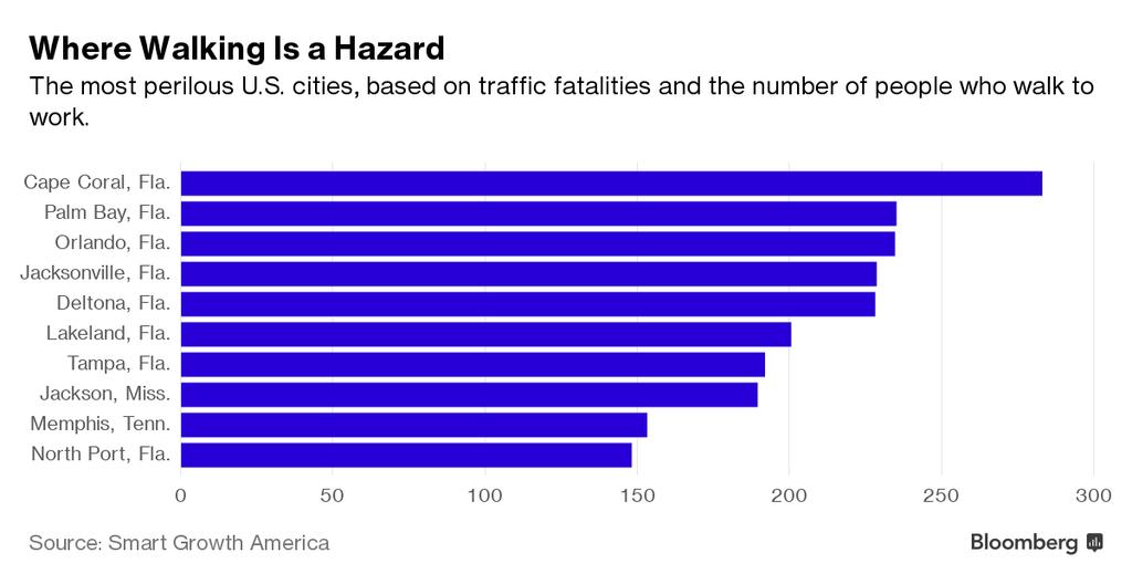
7 PUBLIC HEALTH & SAFETY City plan will address Jacksonville's 'jarring' pedestrian death rate Times Union Dec 5, 2015 So far this year [2015] 41 pedestrians died on Jacksonville streets, according to the Sheriff s Office. Ten have been reported since Oct. 7. In 2013 Jacksonville s rate of pedestrian deaths was second only to Detroit, according to the latest analysis available from the National Highway Traffic Safety Administration. Downtown Streets Are We Strangling Ourselves on One-Way Networks? Transportation Research Board 1999 Urban Streets Symposium: "In traffic engineering circles, the operational disadvantages associated with one-way streets are becoming increasingly recognized. The system...[causes] an increase in the number of turning movements and total miles of travel. One-way streets present challenges to the pedestrian due to speed and pedestrian expectations at intersections... there are simply more (typically percent) vehicle/pedestrian conflicts within a one-way street network than in a comparable two-way system."

8 PUBLIC HEALTH & SAFETY
9 PUBLIC HEALTH & SAFETY Two-Way Street Conversion Evidence of Increased Livability in Louisville Journal of Planning and Education Research, March 2015; Will Rigs 1 and John Gilderbloom 2 1 California Polytechnic State University, San Luis Obispo, CA, USA 2 University of Louisville, Louisville, KY, USA In 2011, the city [Louisville] converted two one-way streets (Brook and 1st) in the Old Louisville part of town. Though originally designed as two-way streets, Brook and 1st became one-way after World War II, in keeping with the car-first engineering of the time. In the area of traffic, we show that after the conversion of Brook and 1st Streets to two-way flow, there was a 36 percent and 60 percent reduction in total collisions.
10 QUALITY OF LIFE Two-Way Street Conversion Evidence of Increased Livability in Louisville Journal of Planning and Education Research, March 2015; Will Rigs1 and John Gilderbloom2 1California Polytechnic State University, San Luis Obispo, CA, USA 2University of Louisville, Louisville, KY, USA While Louisville experienced a five percent jump in crime during the post-conversion study period (2011 to 2013) as well as the period before conversion (2008 to 2010), a disproportionate amount of crime occurred on multi-lane one-way streets (according to police records). Yet nearly three years after the conversions took place, crime dropped a jaw dropping 23 percent on the converted streets.
![ECONOMIC DEVELOPMENT City of New Haven [Connecticut] Two Way Conversion Final Report June 2014 Strategic Priority: Economic Development One-way streets have a negative impact on storefront exposure](/docs-images/82/86433046/images/11-3.jpg "for those businesses highly dependent on pass-by traffic. As a vehicle stops at or enters an intersection the driver has excellent visibility of the storefronts on the far side of the cross street.")
11 ECONOMIC DEVELOPMENT City of New Haven [Connecticut] Two Way Conversion Final Report June 2014 Strategic Priority: Economic Development One-way streets have a negative impact on storefront exposure for those businesses highly dependent on pass-by traffic. As a vehicle stops at or enters an intersection the driver has excellent visibility of the storefronts on the far side of the cross street. On one-way street networks, storefront exposure is lost when one direction of travel is removed, causing one side of every cross street to be partially eclipsed from view. Approximately 25% of businesses are eclipsed in a one-way network, meaning they are not visible to vehicles travelling on the one-way street.
12 ECONOMIC DEVELOPMENT City of New Haven [Connecticut] Two Way Conversion Final Report June 2014; Strategic Priority: Economic Development The economic development implications have been documented for both conversions to and from one-way streets. Both Chattanooga and Cincinnati saw retail vacancies climb dramatically on the heels of their mid- 20th century conversions of downtown streets from two-way to one-way. Conversely, in the City of West Palm Beach, Florida, property values along Clematis Street increased from $10-40 per square foot to $ per square foot after converting from one-way to two-way. Commercial rents increased from $6 per square foot to $30 per square foot, and retail vacancies went from 50% to 0%.
13 LEVEL OF SERVICE The Case Against One-Way Streets The Atlantic, January 21, 2013; The typical metric of traffic is vehicle flow which amounts, more or less, to standing on the corner and counting how many cars go by. Flow is high on one-way streets because there's little reason for cars to slow down. But flow doesn't take into account the fact that traveling through one-way street systems often means taking a circuitous route, which adds distance to every trip. "You can move more vehicles through a roadway, but if they have to travel a longer distance, in the end, you have actually fewer people being able to get to their destination and get off the road. - Dr. Vikash Gayah, Assistant Professor of Civil Engineering, Penn State University

14 LEVEL OF SERVICE
By Dan Burden, Executive Director Walkable and Livable Communities Institute
 By Dan Burden, Executive Director Walkable and Livable Communities Institute Is this the landscape we want to leave our children? LaJolla Boulevard, Birdrock, San Diego, CA 78 Feet Speeds above
Mainstreet Master Plan Land Use
 Mainstreet Master Plan 04 Land Use Top Recommendations Active Uses: Promote active ground-floor uses such as retail, restaurants, galleries and personal services with interactive storefronts for Mainstreet
Multimodal Transportation Plan
 Multimodal Transportation Plan The Multimodal Transportation Plan will accommodate MILLENIALS ARE DRIVING LESS. WE CANNOT BUILD OUR WAY all modes of transportation by keeping pedestrians, OUT OF CONGESTION.
Uniting Cleveland through the Euclid Corridor Transportation Project
 Zhang 1 Uniting Cleveland through the Euclid Corridor Transportation Project Jinmeng Zhang As a bus passenger takes a ride to downtown Cleveland through Euclid Avenue, constructions can be seen along the
WALK- AND bike-friendly TURLOCK
 WALK- AND bike-friendly TURLOCK Ideas to Encourage Walking and Biking Benefits to the COMMUNITY Get Connected People who walk and bike have many more opportunities for casual interactions with friends
G AT E WAY PLAN. Community BRIEFING KIT GATEWAY BIKE
 G AT E WAY PLAN GATEWAY BIKE Community BRIEFING KIT PLAN August 2016 TABLE OF CONTENTS INTRODUCTION... 1 THE BENEFITS OF A BIKEABLE COMMUNITY... 2 ECONOMY...2 SAFETY...3 HEALTH...3 HOUSEHOLD SPENDING...3
Bicycle Boulevards and Neighborhood Greenways
 Bicycle Boulevards and Neighborhood Greenways Traffic Safety is Improving for Everyone 90 80 70 60 50 40 30 20 10 0 PORTLAND: TOTAL TRAFFIC FATALITIES 1986-2008 1986 1987 1988 1989 1990 1991 1992 1993
EXECUTIVE SUMMARY. Vision
 Vision Walking and bicycling in Salt Lake City will be safe, convenient, comfortable, and viable transportation options that connect people to places, foster recreational and economic development opportunities,
How To Encourage More Efficient Transportation in Brazilian Cities
 How To Encourage More Efficient Transportation in Brazilian Cities Todd Litman Victoria Transport Policy Institute Presented Seminar on Discouraging The Use Of Cars São Paulo, Brazil 3 September 2013 Creating
Active Community Design: Why Here? Why Now?
 Active Community Design: Why Here? Why Now? Chris Holm Development Review Coordinator 20 April, 2015 Sacramento, California Our environment has changed North Natomas We ve rapidly urbanize our open space
Franklin Parking Analysis
 Franklin Parking Analysis Report Prepared for: The Town of Franklin, North Carolina Report prepared by: 525 N. Main Street Waynesville, NC 28786 Town of Franklin Parking Study J.M. Teague Engineering 1
Chapter 2. Bellingham Bicycle Master Plan Chapter 2: Policies and Actions
 Chapter 2 Bellingham Bicycle Master Plan Chapter 2: Policies and Actions Chapter 2: Policies and Actions The Bicycle Master Plan provides a road map for making bicycling in Bellingham a viable transportation
Pedestrian Safety at Roundabouts. Presentation to the Howard-Suamico School Board November 26, 2007
 Pedestrian Safety at Roundabouts Presentation to the Howard-Suamico School Board November 26, 2007 Roundabouts that have replaced stop signs and traffic signals have reduced the number and severity of
How to Develop a Pedestrian Safety Action Plan
 How to Develop a Pedestrian Safety Action Plan Course Introduction Presented by: Peter Eun FHWA RC Safety Engineer Ryan Snyder President, Ryan Snyder Associates, LLC Paul Zykofsky Director, Land Use and
Bicycle Facilities Planning
 Bicycle Facilities Planning Overview Types of Cyclists Purpose for Riding Types of Facilities Bike Lanes Bicycle Boulevards Cycle Tracks Intersections Signals Signing and Marking Discussion Types of Bicyclists
RESOLUTION NO ?? A RESOLUTION OF THE CITY OF NEPTUNE BEACH ADOPTING A COMPLETE STREETS POLICY
 RESOLUTION NO. 2018-?? A RESOLUTION OF THE CITY OF NEPTUNE BEACH ADOPTING A COMPLETE STREETS POLICY WHEREAS, safe, convenient, and accessible transportation for all users is a priority of the City of Neptune
PEDESTRIAN ACTION PLAN
 ATTACHMENT 2 CITY OF SANTA MONICA PEDESTRIAN ACTION PLAN CITY OF SANTA MONICA PEDESTRIAN ACTION PLAN This page intentionally left blank EXECUTIVE SUMMARY CHAPTER 1 EXECUTIVE SUMMARY Setting the Stage
What s Health Got to Do With It? Health and Land Use Planning
 What s Health Got to Do With It? Health and Land Use Planning CANDACE RUTT, PH.D. EXECUTIVE DIRECTOR APRIL 13 TH, 2016 Planning and Public Health Planning + Public Health Healthy Communities Healthier
NACTO Designing Cities 2014 Dongho Chang, City Traffic Engineer October 23, 2014
 NACTO Designing Cities 2014 Dongho Chang, City Traffic Engineer October 23, 2014 Presentation overview Perspective on Safety Changing needs of our cities How Seattle is meeting those needs Challenge for
TOWN OF WILLIAMSTON, SC BICYCLE AND PEDESTRIAN MASTER PLAN TOWN OF WILLIAMSTON, SC BICYCLE AND PEDESTRIAN MASTER PLAN
 TOWN OF WILLIAMSTON, SC BICYCLE AND PEDESTRIAN MASTER PLAN Americans Want Choices 55% of Americans would rather drive less & walk more. Transit use is growing faster than population or highway travel.
Creating walkable, bikeable and transit-supportive communities in Halton
 Creating walkable, bikeable and transit-supportive communities in Halton By presenting current research and best practices, the information in this paper is meant to support and broaden discussion on how
City of Novi Non-Motorized Master Plan 2011 Executive Summary
 City of Novi Non-Motorized Master Plan 2011 Executive Summary Prepared by: February 28, 2011 Why Plan? Encouraging healthy, active lifestyles through pathway and sidewalk connectivity has been a focus
CITY OF COCOA BEACH 2025 COMPREHENSIVE PLAN. Section VIII Mobility Element Goals, Objectives, and Policies
 CITY OF COCOA BEACH 2025 COMPREHENSIVE PLAN Section VIII Mobility Element Goals, Objectives, and Policies Adopted August 6, 2015 by Ordinance No. 1591 VIII MOBILITY ELEMENT Table of Contents Page Number
WELCOME. Purpose of the Open House. Update you on the project. Present a draft recommended plan. Receive your input
 WELCOME Purpose of the Open House The Town of Smiths Falls has initiated the Beckwith Street Redevelopment Plan that includes the preparation of a streetscape functional design for the renewal of Beckwith
Complete Streets 101: The Basics
 Complete Streets 101: The Basics Michigan Municipal League - Capital Conference March 21, 2017 Chip Smith, AICP - Senior Planner - Wade Trim Inc. and City Council member City of Ann Arbor 2017 MML Capital
Monterey Road Complete Streets
 Monterey Road Complete Streets Complete Street Objectives Improve livability and economic vitality Enhance pedestrian environment Accommodate bicyclists safely Reduce noise and air pollution Create attractive,
Access Management Benefits & Techniques. Access Management Workshop June 2, 2006
 Access Management Benefits & Techniques Access Management Workshop June 2, 2006 1 Benefits of Access Management Safety As access density increases, crash rates increase Increasing the density of access
Perryville TOD and Greenway Plan
 Perryville TOD and Greenway Plan Greenway Glossary Pathway: A bicycle and pedestrian path separated from motorized vehicular traffic by an open space, barrier or curb. Multi-use paths may be within the
FACTS AND FIGURES: MAKING THE CASE FOR COMPLETE STREETS IN LEE COUNTY
 FACTS AND FIGURES: MAKING THE CASE FOR COMPLETE STREETS IN LEE COUNTY Safety: Close to 5,000 pedestrians and bicyclists die each year on U.S. roads, and more than 70,000 are injured. [Mean Streets, Surface
Introduction. Who is WILMAPCO. Why are walkable communities important
 Walkable Community Workshops Round 1 April 2005 SPONSORED BY WILMAPCO AND CCOBH CITY OF NEW CASTLE EDGEMOOR GARDENS CIVIC ASSOCIATION WITH FUNDING BY DELAWARE DEPARTMENT OF TRANSPORTATION AND THE DELAWARE
Appendix C 3. Bicycle / Pedestrian Planning
 Appendix C 3. Bicycle / Pedestrian Planning BICYCLE/PEDESTRIAN PLANNING 2005 Master Plan GOAL: Provide for safe and convenient bicycle and pedestrian circulation throughout the City. Develop a city-wide
Vision: Traditional hamlet with an attractive business/pedestrian friendly main street connected to adjacent walkable neighborhoods
 N D. Focus Area II Vision: Traditional hamlet with an attractive business/pedestrian friendly main street connected to adjacent walkable neighborhoods Transit Road Focus Area II is located in the Hamlet
PEDALING FORWARD. A Glance at the SFMTA s Bike Program for SFMTA.COM
 PEDALING FORWARD A Glance at the SFMTA s Bike Program for 2017-2021 SFMTA.COM INTRODUCTION About This Booklet More people from all walks of life see their bicycle as a more convenient way to get where
Completing the Vision
 Villas of Positano Completing the Vision North A1A Lane Reconfiguration N. Surf Rd. Redirection of Traffic Margaritaville Resort March 4, 2014 1 Completing The Vision Project Limits Hollywood Blvd. to
CONNECTIVITY PLAN. Adopted December 5, 2017 City of Virginia Beach
 CONNECTIVITY PLAN Adopted December 5, 2017 City of Virginia Beach CONTENTS 1.0 Background & Purpose... 2 2.0 Existing Inventory & Analysis... 3 ViBe District Existing Walking Conditions... 4 3.0 ViBe District
Streets. Safe for Pedestrians 20% 2nd 5,000. Are We People-Friendly?
 Streets Safe for Pedestrians 20% Pedestrian deaths account for more than of all traffic-related fatalities in California each year. 600 More than people are killed and another 13,000 are injured every
DRAFT MOVING FORWARD RHODE ISLAND BICYCLE MOBILITY PLAN 2018 PREPARED FOR PREPARED BY IN ASSOCIATION WITH
 RHODE ISLAND MOVING FORWARD BICYCLE MOBILITY PLAN 2018 PREPARED FOR PREPARED BY IN ASSOCIATION WITH T AF CHAPTER 1 D R INTRODUCTION CHAPTER 3 ARTICULATES VISION Bicycling is safe, fun and practical in
CONNECTING PEOPLE TO PLACES
 CONNECTING PEOPLE TO PLACES 82 EAST BENCH MASTER PLAN 07 Introduction The East Bench transportation system is a collection of slow moving, treelined residential streets and major arteries that are the
Healthy Built Environments Cowlitz-Wahkiakum County, Washington
 Healthy Built Environments Cowlitz-Wahkiakum County, Washington Bringing Back Active Transportation and Health Presented By Dan Burden, Blue Zones, LLC Livability/Health and the role of Place, Walkability
The Wiggle Route in Context
 The Wiggle Route in Context In a city of hills, the Wiggle is an important route because it winds its way along the flattest streets from Market to the Panhandle, bringing residents to local parks and
CITY OF SLO SEEKS INPUT ON PREFERRED ALTERNATIVE FOR BROAD STREET BICYCLE BOULEVARD PROJECT
 City of San Luis Obispo, News Release DATE: August 1, 2017 RELEASE: Immediate CONTACT: Luke Schwartz (805) 781-7190 Transportation Planner-Engineer, Public Works CITY OF SLO SEEKS INPUT ON PREFERRED ALTERNATIVE
Section 8. Partnerships and Funding
 This section discusses the potential partnership and funding options that the Town should consider in order to assist with the implementation of the recommendations provided in the Plan. Section 8. Partnerships
The best indicator of an individual s and expanding access to parks and open space.
 Health & Wellness Create a Safe and Healthy Built Environment Artist s rendering, 2014 Health is important to Loveland residents, and stakeholders see the many strong connections between quality of life,
DOWNTOWN TUPELO MAIN STREET: ROAD DIET STUDY
 DOWNTOWN TUPELO MAIN STREET: ROAD DIET STUDY Since mid-2009, RPM Transportation Consultants (RPM) has worked with the Downtown Tupelo Main Street Association to evaluate traffic conditions and potential
Florida Redevelopment Association 2015 Annual Conference
 Florida Redevelopment Association 2015 Annual Conference Reimagining State Arterials Jeff Costello, Delray Beach CRA Executive Director I-95 Fed. Hwy Pairs Two blocks west of Intracoastal Waterway One-way
NEWMARKET UPHAM S CORNER
 SOUTH STATION Planning Initiative NEWMARKET UPHAM S CORNER COLUMBIA ROAD (P) FOUR CORNERS/GENEVA Working Advisory Group (WAG) Meeting #5 TALBOT AVENUE MORTON STREET BLUE HILL AVE/CUMMINS HWY (P) RIVER
Designing for Pedestrian Safety
 Designing for Pedestrian Safety Introduction to Pedestrian Safety Design and Planning Principles Presented by: Craig Allred FHWA Resource Center Technical Specialist and Michael Ronkin Owner, Designing
A CHANGING CITY. of Edmonton, it is essential that it reflects the long-term vision of the City.
 A CHANGING CITY By the year 2040, Edmonton will be home to more than 1 million people. To accommodate growth and support a healthy and compact city, we need a new approach to development/redevelopment
LANCASTER CITY BICYCLE NETWORK
 LANCASTER CITY BICYCLE NETWORK Downtown Merchants Meeting Wednesday, July 19, 2017 http://www.lancasteratp. DOWNTOWN WALKABILITY ANALYSIS What changes can be made, in the least amount of time, and for
GRAHAM PEDESTRIAN TRANSPORTATION PLAN
 GRAHAM PEDESTRIAN TRANSPORTATION PLAN Chapter 1 I 1.1 Scope and Purpose n March of 2005, the City of Graham contracted with Greenways Incorporated (GWI) to create a Pedestrian Transportation Plan. The
Cherry Creek Transportation and Land Use Forum September 25, 2013 Meeting Summary
 Cherry Creek Transportation and Land Use Forum September 25, 2013 Meeting Summary I. LEAD-IN TO SMALL GROUP DISCUSSION, POLLING AND STEERING COMMITTEE/TECHNICAL TASK FORCE DISCUSSION The meeting began
Use this guide to learn more about walkability and how you can make your community safer to walk
 Walkability Guide Do You Enjoy Walking In Your Community? Use this guide to learn more about walkability and how you can make your community safer to walk 2 About This Guide Circulate San Diego believes
Observations from an Emerging Bike Culture Chris & Melissa Bruntlett Tuesday, November 4 th, #AKLConversations
 Observations from an Emerging Bike Culture Chris & Melissa Bruntlett Tuesday, November 4 th, 2014 @modacitylife #AKLConversations Vancouver Bike Culture Prior to 2008 Mayor Gregor Robertson Doubled annual
Complete Streets. Designing Streets for Everyone. Sarnia
 Complete Streets Designing Streets for Everyone Sarnia Complete Streets ~ Sarnia ~ 2018 Introduction Our City is made up of a network of streets that we use to go for a walk, cycle to work, drive to the
Focus on New Baseline Conditions, Indicators and Analytic Approaches
 Focus on New Baseline Conditions, Indicators and Analytic Approaches Lindsey Realmuto, MPH Health Program Planner San Francisco Department of Public Health Overview HIA Assessment Tools HDMT and Baseline
Table #6 VISION CHARACTERISTICS
 Table #6 VISION White Flint is a place to live, work, play, shop, and walk with sufficient density to encourage quality redevelopment. Vibrant streets and consistent streetscapes are important. CHARACTERISTICS
Planning Regionally With Transit
 Planning Regionally With Transit Nathan Coats Director of Operations CTAA Expo 2015 Tampa Began 1992. Serves eastern Cache County to Preston, ID. Population- 115,000 34 bus fleet, 26 fixed route buses;
Thank you for this opportunity to discuss with you how we can work together to make our streets more complete.
 Thank you for this opportunity to discuss with you how we can work together to make our streets more complete. 1 2 3 Thank you for this opportunity to discuss with you how we can work together to make
Safe Routes to School Blue Zones Project, City of
 Safe Routes to School Blue Zones Project, City of Fort Worth and FWISD Partnership Introduction to Blue Zones Project Blue ZonesProject is a well-being improvement initiative designed to make healthy choices
Public Workshop #2. September 14, 2016
 Public Workshop #2 September 14, 2016 Agenda Welcome Project Overview Where We Have Been Alternatives for State Street Land Use Street Design Next Steps 2 Project Overview Create a Vibrant State Street
Potential Bicycle Facility on Bayou Street Mobile, Alabama
 Potential Bicycle Facility on Bayou Street Mobile, Alabama By Richard A. Hall, P.E. Prepared For Mobile Downtown Alliance Hall Planning & Engineering, Inc. March 28, 2018 Introduction Review of the February
5 Circulation & Parking
 5 Circulation & Parking Downtown Parking & Circulation Strategy. Downtown Wayne has a somewhat disconnected system of local public streets to connect downtown with the residential neighborhoods, and primary
The DC Pedestrian Master Plan
 The DC Pedestrian Master Plan September 28, 2010 George Branyan Pedestrian Program Coordinator District Department of Transportation Presentation Agenda Scope of the Plan Methodology Recommendations Implementation
Mission-Geneva Transportation Study Community Workshop 2 July 8, 2006
 Community Workshop 2 July 8, 2006 Small Group Workbook 1 Basic Improvements on Mission Street Streetscape. Pedestrian-scale lighting; landscaping; community art on utility boxes; more (possibly unique)
Illustrated Principles of Good Planning
 Illustrated Principles of Good Planning The Miami 21 Zoning Code incorporates time-tested planning principles into the zoning regulations of our City. These are principles that make for better neighborhoods,
Downtown Naples Mobility and Connectivity Study. Naples City Council Presentation January 2017
 Downtown Naples Mobility and Connectivity Study Naples City Council Presentation January 2017 Agenda 1. Introduction 2. Scope Review 3. Project Schedule 4. Existing Conditions 5. Public Charrette 6. Mobility
TOWN OF PORTLAND, CONNECTICUT COMPLETE STREETS POLICY
 TOWN OF PORTLAND, CONNECTICUT COMPLETE STREETS POLICY I. VISION, GOALS & PRINCIPLES VISION To improve the streets of Portland making them safer and more accessible for all users including pedestrians,
Richmond Connects Visioning Update
 Richmond Connects Visioning Update To date there have been four elements of the visioning process: Vision20 Night at Byrd Theatre on May 3rd Advisory Committee Meeting on May 12 th Public Visioning Workshop
5. Automobile Circulation, Wayfinding and Signage
 5. Automobile Circulation, Wayfinding and Signage Policy: The City Center should have a balanced, safe, and interconnected circulation system that provides expanded travel opportunities for transit, pedestrian,
COLUMBUS AVENUE NEIGHBORHOOD TRANSPORTATION STUDY
 COLUMBUS AVENUE NEIGHBORHOOD TRANSPORTATION STUDY Pedestrian Survey Findings Survey Main Findings: Transit and walking are the main two modes used by both visitors and residents of the area, regardless
Creating Complete Streets to Accommodate All Users
 Creating Complete Streets to Accommodate All Users Peter Lagerwey, Toole Design Group plagerwey@tooledesign.com Brian Dougherty, Seattle DOT brian.dougherty@seattle.gov International Conference on Urban
Complete Streets Accessible Networks for an Age-Friendly World
 Complete Streets Accessible Networks for an Age-Friendly World Jana Lynott, AICP Senior Strategic Policy Advisor AARP Public Policy Institute @JanaLynott What are Complete Streets? AARP Bulletin Complete
SFMTA PROJECT TIMELINE
 SFMTA PROJECT TIMELIE Internal SFMTA Processes Opportunities for Public Input Data Collection and Analysis Car and bike volumes, safety (collision) data Roadway and intersection geometry June 2016 Pop
Appendix C. TRAFFIC CALMING PROGRAM TOOLBOX
 Appendix C. TRAFFIC CALMING PROGRAM TOOLBOX PHASE I...2 Do Not Enter Sign...3 One-Way Sign...4 Turn Prohibition...5 Pavement Markings...6 Speed Monitoring Trailer...7 Neighborhood Speed Watch...8 Police
8. Collisions INTRODUCTION
 8. Collisions INTRODUCTION While traffic collisions can affect anyone, they have a disproportionate impact on bicyclists, who along with pedestrians are the most vulnerable users of the transportation
Simulation Analysis of Intersection Treatments for Cycle Tracks
 Abstract Simulation Analysis of Intersection Treatments for Cycle Tracks The increased use of cycle tracks also known as protected bike lanes has led to investigations of how to accommodate them at intersections.
Approaches. Livable Neighborhood Design. Examples. Traditional neighborhood development. CE 594 University of Wisconsin- Milwaukee
 Approaches Livable Neighborhood Design CE 594 University of Wisconsin- Milwaukee Traditional neighborhood design (TND), new urbanism, transit friendly design, transit oriented development and walkable
Plant City Walk-Bike Plan
 Plant City Walk-Bike Plan Plant City Commute Mode Share 2.2% 1.4% 2.9% Drove alone 10.2% Carpooled Public transportation (0.1%) Walked Used a Bike (0.4%) 82.9% Taxicab, motorcycle, or other means Worked
A Study of Effectiveness of Midblock Pedestrian Crossings: Analyzing a Selection of High-Visibility Warning Signs
 : Analyzing a Selection of High-Visibility Warning Signs Rebekka Apardian Bhuiyan Monwar Alam Associate Professor, Department of Geography & Planning, The University of Toledo, Abstract The purpose of
Implementation Matrix
 Downtown Delaware Parking Study Short Term Mid Term Long Term = Within one year = Within three years = More than three years The highlighted proposed enhancements will require a substantial amount of input
Bridgewater Complete Streets Prioritization Plan and Pedestrian Safety Assessment
 Bridgewater Complete Streets Prioritization Plan and Pedestrian Safety Assessment Presented by Luciano Rabito Manager of Complete Streets Presented to Bridgewater, MA Wednesday, April 26, 2017 6:30 P.M.
RESTRICTED ROADS (20 MPH SPEED LIMIT) (SCOTLAND) BILL. 1. Is reducing the speed limit to 20mph the best way of achieving the aims of the Bill?
 (SCOTLAND) BILL. 1. Is reducing the speed limit to 20mph the best way of achieving the aims of the Bill?") RURAL ECONOMY AND CONNECTIVITY COMMITTEE RESTRICTED ROADS (20 MPH SPEED LIMIT) (SCOTLAND) BILL SUBMISSION FROM CYCLE STIRLING Questions 1. Is reducing the speed limit to 20mph the best way of achieving
RURAL ECONOMY AND CONNECTIVITY COMMITTEE RESTRICTED ROADS (20 MPH SPEED LIMIT) (SCOTLAND) BILL SUBMISSION FROM CYCLE STIRLING Questions 1. Is reducing the speed limit to 20mph the best way of achieving
Front and Myrtle Improvement Project
 Front and Myrtle Improvement Project MAKING BOISE THE MOST LIVABLE CITY IN THE COUNTRY DOWNTOWN: Our unique and vibrant urban neighborhood GUIDING PRINCIPLES: Innovation Celebration Transportation Downtown
The Northern Avenue Bridge is being replaced, and the city is debating just who will be allowed to use it
 The Northern Avenue Bridge has been closed to vehicles since 1997 and to pedestrians since 2014. The Northern Avenue Bridge is being replaced, and the city is debating just who will be allowed to use it
DANGEROUS BY DESIGN WISCONSIN. Solving the Epidemic of Preventable Pedestrian Deaths (And Making Great Neighborhoods)
") DANGEROUS BY DESIGN 2011 WISCONSIN Solving the Epidemic of Preventable Pedestrian Deaths (And Making Great Neighborhoods) DANGEROUS BY DESIGN 2011 Wisconsin T4AMERICA.ORG Dangerous by Design 2011: Wisconsin
DANGEROUS BY DESIGN 2011 WISCONSIN Solving the Epidemic of Preventable Pedestrian Deaths (And Making Great Neighborhoods) DANGEROUS BY DESIGN 2011 Wisconsin T4AMERICA.ORG Dangerous by Design 2011: Wisconsin
Congestion Evaluation Best Practices
 Congestion Evaluation Best Practices Todd Litman Victoria Transport Policy Institute Presented International Transportation and Economic Development Conference 10 April 2014 Congestion Indicators Indicator
Monroe Street Reconstruction Business Focus Group Notes July 18, 2016, HotelRED
 Monroe Street Reconstruction Business Focus Group Notes July 18, 2016, HotelRED Total participants: 31 Focus Group Conversation #1: During this exercise, participants talked in small table groups in response
CHAPTER 1 INTRODUCTION
 CHAPTER 1 INTRODUCTION Chapter Table of Contents THE 2017 HOUSTON BIKE PLAN 1-1 HOUSTON BIKEWAYS PROGRAM 1-2 HISTORY OF BICYCLE PLANNING IN HOUSTON 1-3 BICYCLE LEVEL OF COMFORT 1-3 EXISTING PLANS, PROGRAMS
Access Management in the Vicinity of Intersections
 Access Management in the Vicinity of Intersections FHWA-SA-10-002 Technical Summary Photo: Ralph Bentley (used with permission) 0 Access Management is: The design, implementation and management of entry
EXECUTIVE SUMMARY: TRANSIT-ORIENTED DEVELOPMENT IN SMITHS FALLS, ONTARIO; A COMPARISON BETWEEN TWO SITES
 EECUTIVE SUMMARY: TRANSIT-ORIENTED DEVELOPMENT IN SMITHS FALLS, ONTARIO; A COMPARISON BETWEEN TWO SITES Topic and Purpose In 2007, the Mayor of Ottawa s Task Force on Transportation suggested adding a
Tuesday, September 25 th Mount Holly Municipal Complex 400 East Central Avenue 5:30pm to 7:30pm. Activity Stations o Where do you Live?
 Meeting Information Overview The public workshop for the Mount Holly Comprehensive Bicycle Plan occurred on September 25, 2018. The drop-in workshop allowed attendees to participate in a series of interactive
LTAP Fact Sheet. Abuzz word among transportation professionals. Kansas. Smarter, Safer Roadways: Road Diets for Rural Communities.
 Spring 2009 Kansas LTAP Fact Sheet A Service of Kansas University Transportation Center for Road, Street & Bridge Agencies Smarter, Safer Roadways: Road Diets for Rural Communities By Mehrdad Givechi,
phoenix regional bike share program sponsorship
 phoenix regional bike share program sponsorship High visibility opportunities to promote a healthy lifestyle and sustainable transportation in the Phoenix area what is bike share? Bike share programs are
Bicycle and Pedestrian Advisory Committee (BPAC) November 21, 2013
 November 21, 2013") Bicycle and Pedestrian Advisory Committee (BPAC) November 21, 2013 OVERALL LAND USE CONCEPT Overall Broadway Valdez District: 95.5 acres (35.1 acres right-of ways + 60.4 acres developable land) Plan Subareas:
Bicycle and Pedestrian Advisory Committee (BPAC) November 21, 2013 OVERALL LAND USE CONCEPT Overall Broadway Valdez District: 95.5 acres (35.1 acres right-of ways + 60.4 acres developable land) Plan Subareas:
1000 FRIENDS OF FLORIDA PALM BEACH COUNTY 2070 OCTOBER 2018
 1000 FRIENDS OF FLORIDA PALM BEACH COUNTY 2070 OCTOBER 2018 HEALTHIER COMMUNITIES & BETTER ECONOMIES THROUGH COMPLETE STREETS PRESENTED BY TREASURE COAST REGIONAL PLANNING COUNCIL The Question of Safety
Berkeley Strategic Transportation Plan A-76
 Berkeley Strategic Transportation Plan A-76 Appendices 1. A Team Effort 2. Where We ve Been A-11 Berkeley Strategic Transportation Plan Alameda County Transportation Plan Alameda County will be served
Montford Drive Parking & Circulation Study
 Montford Drive Parking & Circulation Study Parking & Circulation Study Follow up to the Area Plan based on what we heard Purpose 1 2 3 4 To look closer and evaluate parking and network related issues (including
Why Zone In on Speed Reduction?
 Learn it. Do it. Live it! SPEED REDUCTION IN THE ZONE Why Zone In on Speed Reduction? Speeding is a serious issue that plays a major role in the risk of serious injury and pedestrian fatality in a crash.
Classification Criteria
 SCHEDULE D TO RECOMMENDED OFFICIAL PLAN AMENDMENT NO. 40 SCHEDULE C-4 Road Criteria Criteria Traffic Service Objective Land Service/Access Typical Daily Traffic Volume Flow characteristics Travel Speed
Speed Limits in the Hoddle Grid
 Speed Limits in the Hoddle Grid Recent History of speed limits March 2013 Docs # 7738485 1 Introduction Muncipalities have power to Erect speed limit signs BUT Municipalities DO NOT have the power to approve