Coordinating Land Use and Transportation (and Traffic Safety)
|
|
|
- Shannon Goodman
- 5 years ago
- Views:
Transcription
1 Coordinating Land Use and Transportation (and Traffic Safety) Design for Health University of Minnesota Reid Ewing National Center for Smart Growth
2 Give Them War Stories and Codes Well Maybe Not
3 Considering Traffic Safety Worldwide, more than 1 million people are killed in traffic crashes each year. Up to 50 million more are injured. More than half are pedestrians. Traffic injuries and fatalities are projected to increase by 65% by Source: World Health Organization, 2004
4 Traffic Safety in the United States Fatality Rates for U.S. Roadways Fatalities Per Million Population Fatalities Per Million VMT Source: Dumbaugh, 2005
5 Design Improvements? Changes in highway infrastructure have not reduced traffic fatalities and injuries and have even had the effect of increasing total fatalities and injuries Safety improvements attributable to : Demographics Increases in Seat Belt Use Medical technology - Robert Noland, 2003
6 Peer Comparisons Currently, we rank behind all other developed countries Road Traffic Fatalities (2000) Country or Area Per 100,000 Inhabitants Australia 9.5 European Union* 11 Great Britain 5.9 Japan 8.2 Netherlands 6.8 Sweden 6.7 United States 15.2 Austria, Belgium, Denmark, Finland, France, Germany, Greece, Ireland, Italy, Luxembourg, Netherlands, Portugal, Spain, Sweden, United Kingdom Source: World Health Organization
7 Development Patterns Importance of Exposure
8 Mostly Exposure

9 VMT vs. Sprawl

10 Fatal Accidents vs. Sprawl
11 Speed Accounts for Difference 600 Stopping Sight Distance (ft) Design Speed (mph)
12 Roadway Design They Got It All Wrong
13 The Conventional Wisdom: Passive Safety Paradigm
14 Highway Safety Hearings of 1966 What we must do is to operate the 90% or more of our surface streets just as we do our freeways [converting] the surface highway and street network to freeway road and roadside conditions. - Kenneth A. Stonex, 1966
15 The Alternative Active Safety Paradigm

16 Wider, Straighter, Longer, Faster every effort should be made to use as high a design speed as practical to attain a desired degree of safety

17 Urban =/ Rural /
18 Speed Is the Main Issue 600 Stopping Sight Distance (ft) Design Speed (mph)


19 Wide Lanes
20 Lane Width Studies on lane widths report mixed results, with some studies finding wider lanes are safer, and other finding wider lanes are more dangerous. In general, lane widths appear to have a U shaped relationship with crash performance, with crashes decreasing until lane widths reach roughly 11.5 feet, and increasing thereafter. Sources: Clark, 1985; Dumbaugh, 2005; Farouki and Nixon, 1976; Fitzpatrick et al., 2001; Gattis and Watts, 1999; Harwood, 1990; Hauer, 1999; Heimbach et al., 1983; Lee and Mannering, 1999; Noland and Oh, 2004; Zegeer, Deen and Mayes,1981.

21 More Lanes Studies consistently find that adding lanes increases crashes, while eliminating lanes though road diet projects decreases crashes. Sources: Dumbaugh, 2005; Harwood, 1986; Harwood,1990; Huang, Stewart, and Zegeer, 2001; Knapp and Giese, 2001; Milton and Mannering, 1998; Noland and Oh, 2004; Sawalha and Sayed (2001); Vitalano and Held 1991.


22 Wide Corners


23 Wide Clear Zones


24 Which Is Safer?
25 Conclusions About Traffic Safety Many of the conventional assumptions on traffic safety are unsubstantiated by empirical research. Sprawling areas generally have higher rates of both pedestrian and motor vehicle crashes. Livable street improvements are consistently safer than conventional roadway designs. Few studies have meaningfully linked safe roadway design to the characteristics of the built environment yet this is a clearly fruitful area for future research
26 Land Oriented Approaches State Growth Management Initiatives Coordinated Regional Planning Integrated Community Design Transit-Oriented Development Joint Development
27 Transportation Oriented Approaches Context-Sensitive Highway Design Traffic Calming Access Management Street Network Design Adequate Public Facilities Requirements
28 Illustrated with Five Successful Developments Urban TOD Downtown Bethesda, MD Suburban TOD Orenco Station, OR Neo-Traditional Village Southern Village, NC New Town in Town Baldwin Park, FL Redesigned Suburb University Place, WA Redesigned City Charlotte, NC
29 5 Ds of Land Development
30 Urban TOD Public Investment Driven Development Bethesda, MD

31 Montgomery County s General Plan: Wedges and Corridors in 1964 Urban Ring I-270 Corridor Suburban Communities Residential Wedge Argicultural Wedge


32 Planning Areas

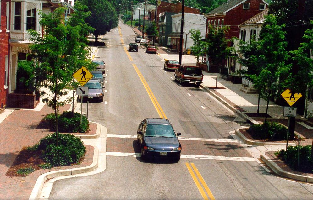
33 Downtown Bethesda
34 Qualifies as an Edge City 400-ac suburban downtown 8 million sf of office (39,000 jobs) 2.3 million sf of retail 5,000 housing units ±

35 Density Units per Acre (gross)

36 Classic Density Gradient

37 Diversity -- Seamless


38 Design -- Interconnected and Varied Spaces


39 Continuous Sidewalks Appropriately Scaled


40 Safe Crossings

41 Minimal Dead Space


42 Human-Scale Buildings


43 Super Blocks with Pass-Throughs

44 Connectivity Index of 1.49


45 Distance to Transit

46 5th D -- Parking
47 Parking Ratios 1.9 spaces per 1,000 sq ft w/i 800 ft not all on site 2.1 spaces per 1,000 sq ft from 800-1,600 ft 2.4 spaces per 1,000 sq ft beyond 1,600 ft
48 Road Code Revision
49 Bethesda Town Center s Commute 15% 2% 2% 36% 45% car transit walk other work at home
50 Suburban TOD Command-and-Control Development Orenco Station, Hillsboro, OR

51 2040 Growth Concept Balance land use and transportation Provide cost-effective solutions Provide multi-modal choices Protect neighborhoods, environment Serve freight, inter-modal and commerce needs Enhance safety and preserve the system
52 Transportation Planning Rule

53

54 Portland s Old Standards

55 Portland s New Standards
56 Cul-de-Sac Length Limits Orlando, FL West Linn, OR Austin, TX Beaverton, OR Boulder, CO Middleton, DL Davidson, NC 700 ft/30 dus 400 ft/12 dus 1,200 ft 200 ft 600 ft 1,000 ft 250 ft (closes excepted) * With exceptions for topography or special circumstances.
57 Block Length Limits* Salem, OR Portland, OR Davidson, NC Raleigh, NC Fort Collins, CO Boulder, CO 600 ft ( ft widths) 530 ft 600 ft 1,500 ft Max block size (7-12 acres) 350 ft (by practice) * With exceptions for topography or special circumstances.
58 Portland Metro Study Low -> Medium Connectivity: 14% average drop in vehicle hours of delay 2% average drop in vehicle miles of travel 9% average drop in link traffic volumes * Connectivity defined by number of intersections per mile of arterials. Optimum spacing of local and arterial streets was ft. Kloster et al., Linking Land Use and Transportation through Street Design, Transportation Research Circular E-C019, December 2000.
59 Project Description 1,100 acre new town 52-acre village center concurrent with housing 3,600 -> 4,300 residential units (using full entitlement) 200,000 sf retail uses 800,000 sf of office uses (200,000 sf in village center) Internal bus service planned


60 Tied Together


61 15 Units per Acre

62 Connectivity Index of 1.53

63 Orenco Parkway

64 Limited Rail System

65 Standard Auto Ownership
66 Light Rail Usage 42% of residents considered access to Max very important in home buying decision 78% of residents use transit more than in their prior residence Only 11% ride Max to work at least one day a week


67 But Walkable
68 New-Town In-Town Full Public-Private Partnership Baldwin Park, Orlando, FL

69 Orlando s Mission Statement
70 Orlando Vision Plan
71 Orlando Comprehensive Plan -- Future Land Uses
72 Standards for Activity Centers

73 Land Development Code -- MU Zoning
74 Land Development Code -- Parking Standards

75 Transportation Concurrency Exception Area
76 Traditional Design Standards Allowable Uses Maximum Block Size Minimum Density/Intensity Minimum Frontage Parking Ratios Building Heights
77 Incentives for Traditional Development Higher Densities/Intensities Fee Waivers Expedited Permitting Narrower Streets Lower Transportation Impact Fees
78 Orlando Adopted Connectivity Index


79 Transferred to City Under the Base Closure Act
80 Project Description 1,100 acre new town 52-acre village center concurrent with housing 3,600 -> 4,300 residential units (using full entitlement) 200,000 sf retail uses 800,000 sf of office uses (200,000 sf in village center) Internal bus service planned

81 Baldwin Park


82 13 Units per Acre

83 Dense Core with Dispersed Apts and Offices


84 Vertical and Horizontal Mix in the Town Center

85 Connectivity Index of 1.62


86 28 Connections But No Through-Street

87 Alike Uses Facing Each Other
88 Curb-to-Curb Street Widths Lower Park Rd Shaw Lane Upper Union Rd Meeting Place at choker Meeting Place at parking Prospect Ave 27 ft 22 ft ( ) 21 ft ( ) 11 ft ( ) 19 ft ( ) 36 ft ( )

89 Skinny Streets

90 Even Collectors
91 Neo-Traditional Village Friendly Regulatory Environment Southern Village, NC


92 Two Places that Don t Look Like Sprawl

93 Downzoning to Direct Growth to the Village


94 9 Units per Acre


95 Classic Stepdown Pattern

96 Neighborhood and Village Commercial

97 Southern Village Index of 1.50


98 One Exception to Friendly Regulatory Environment


99 Limited Bus Service

100 Ped-Friendly Design
101 Travel Characteristics Percent of Trips % 90.00% 80.00% 70.00% 60.00% 50.00% 40.00% 30.00% Northern Carrboro Southern Village (single-family) Southern Village (multi-family) 20.00% 10.00% 0.00% External Internal % of neighborhood's trips 100% 90% 80% 70% 60% 50% 40% 30% 20% So. Vill Single Family HHs No. Carrboro Neighborhoods TTA (Region) 10% 0% Car Bus Walk Bike Other
102 Redesigned Suburb Public Sector Lead Bridgeport Way/University Place

103 Original Conditions Functional Class: principal arterial Average Daily Traffic: 19,000-24,000 Through Lanes: 5 Typical Right of Way: feet Length of Section: 1.5 miles Adjoining land uses: commercial, civic, offices, senior housing Transit: highest transit volumes in Pierce County

104 67 Crashes per Year Before 1/3 injury crashes 1/2 right-angle collisions


105 Walking Before
106 Vision Create a main street and town center that provides residents and visitors a comfortable, convenient, efficient, safe, secure and welcoming place to shop, play, work and live.

107 New Street Network


108 Before and After

109 Walking After
110 Traffic Impacts 7% Speed Reduction (35.3 -> 33.4 mph) 60% Crash Reduction (19 -> 8 in five blocks)

111 Full Disclosure


112 Starting Point for Land Use Change
113 Four Years Without Development Activity Site Visits to Life Style Centers Master Plan Charrette Land Assembly (10 -> 15 acres) Three Master Developers Town Center Overlay Zoning Proposed On-Street Parking Intermodal Transportation Center and Streetscape Improvements
114 5-Story Town Center Town Center Plan 88-acre Town Center Design standards Town Center Overlay Zone 75 ft height limit 80 du/ac density cap

115 Final Plan
116 Redesigned City Transportation Action Plan Charlotte, NC

117 How Does Charlotte Stack Up?

118 Dispersal of Jobs Out of the Corridors Three-quarters of Pipeline outside the corridors Major employment projects in the pipeline 1997 Employment
119 Dispersal of Multifamily Housing Multi-family is widely dispersed throughout C-M Major Multi-Family development, 1998 Residential Areas Multi-fam ily
120 Business As Usual Corridor congestion increases Center City declines Jobs decentralize at low densities Jobs start to leave County Multi-family housing widely dispersed
121 Land Use-Transit Plan Goals Transit Corridors offer alternatives to autoonly access. Jobs are concentrated in corridor subcenters. Jobs stay in County. City Center continues to grow. More multi-family housing shifts to corridors
 Res. (5,058 Ac) Non Res. (3,579 Ac) South (18,158 Ac) Res. (5,058 Ac) 37% 27% 36% Non Res. (3,579 Ac) 14% University Non Res. (24,224 Ac) (6,401 Ac) Undev. (10,349 Ac) Undev.")
122 Land Use by Corridor North (44,798 Ac) Undev. (22,149 Ac) 50% 36% Res. (16,248 Ac) egend Undeveloped Residential Non Residential Airport (16,516 AC) Undev. (7,879 Ac) 47% 31% 22% Undev. (7,879 Ac) Res. (5,058 Ac) Non Res. (3,579 Ac) South (18,158 Ac) Res. (5,058 Ac) 37% 27% 36% Non Res. (3,579 Ac) 14% University Non Res. (24,224 Ac) (6,401 Ac) Undev. (10,349 Ac) Undev. (4,839 Ac) Non Res. (3,518 Ac) 43% 31% 26% Res. (7,630 Ac) Non Res. (6,245 Ac) Independence (16,792 Ac) 29% 50% 21% Res. (8,435 Ac)
123 Framework for Testing Land Use Alternatives Trends Bu Business as usual Jobs Focus jobs in corridors Jobs and Housing Focus jobs and housing in corridors Note: Within the alternatives, various options for rail and bus were also tested.

124 Opportunity Area Analysis

125 Opportunities in North Corridor
126 Job Shifts by Transit Corridor Corridor 1997 Trend 2025 Plan 2025 North 57,300 90, ,100 University 28,900 43,500 53,700 Independence 45,900 52,900 57,900 Sout h 45,100 52,800 78,300 Airport 20,500 24,600 29,300 Cent er Cit y 58,800 74,400 90,300 Tot al 256, , ,600 *Defined as one mile centered on transit line
127 Housing Shifts by Transit Corridor Corridor 1997 Trend 2025 Plan 2025 Nort h 16,700 32,500 37,400 Universit y 7,000 10,600 12,500 Independence 14,600 18,900 19,600 Sout h 11,400 16,600 18,500 Airport 3,900 4,600 5,200 Cent er Cit y 2,800 7,900 12,500 Tot al 56,400 91, ,700 *Defined as one mile centered on transit line
128 Ridership Forecast: Triangulation CM-DOT s 4-step method: input to crossclassification estimates modified to reflect lower vehicle ownership rates in TODs TCRP H-1 Model: Estimated station boarding based on 314 LRT station across nine North American cities Post process: non-home end; bus rapid transit; sensitivity testing
129 Went to Voters
130 Need for Rezoning Rat io of Demand (Plan 2025) t o Supply (Zoned Holding Capacit y) Demand/Supply Rat io A value of 1.0 represent s balance bet ween demand and supply; great er t han 1.0 means demand exceeds supply; and less t han 1.0 means supply exceeds demand Nort h Universit y Independence Sout h Airport 0.44 Source: LDR Int ernat ional, Mult ifamily Housing Jobs
131 Station Types Existing/Limited Infill Redevelopment New Residential New Employment New Mixed Use Park & Ride Facilities City Center
132 Transit-Oriented Research Park
133 New Transit Districts Minimum Densities for Station Areas High Maximum Densities by Station Area Administratively Approved Site Plans Explicit and Strong Design Standards Accessory Apartments by Right Lower Parking Standards Reduced LOS Standards in Station Areas Reduced Building Setbacks Reduced Transitional Setbacks
134 Incentives for TDs Joint Development Projects Tax Increment Financing (if Authorized) Assistance with Land Assembly Streamlined Permitting Process In-Kind Services Lower or Delayed Development Fees Eligibility for Energy-Efficient Mortgages Employee Ridersharing Incentives

135 Centers and Corridors

136 Went to Voters

137 Station Area Planning
138 New Zoning Districts Transit-Oriented Development Zoning Districts Transit-Supportive Development Zoning Districts
139 Incentives for TDs Joint Development Projects Tax Increment Financing (if Authorized) Assistance with Land Assembly Streamlined Permitting Process In-Kind Services Lower or Delayed Development Fees Eligibility for Energy-Efficient Mortgages Employee Ridersharing Incentives
140 Transportation Action Plan Connectivity Program Revised Subdivision Ordinance Thoroughfare/Collector Map Bikeway Map New Street Standards Traffic Calming Guidelines


141 New Street Standards


142 Road Diet Projects
143 Traffic Calming Call Ian
* With exceptions for topography or special circumstances.
 Block Length Limits* Salem, OR 600 ft (180 m) Portland, OR Davidson, NC Raleigh, NC Fort Collins, CO Boulder, CO 530 ft 600 ft 1,500 ft Max block size (7-12 acres) 350 ft (by practice) * With exceptions
Sustainability and Livability
 Implementing Abu Dhabi s 21 st Century Vision for Sustainability and Livability Global Context Emirate of Abu Dhabi is the largest of seven nation-states that make up the United Arab Emirates. Abu Dhabi
Clackamas County Comprehensive Plan
 ROADWAYS The County s road system permits the movement of goods and people between communities and regions, using any of a variety of modes of travel. Roads provide access to virtually all property. They
San Jose Transportation Policy
 San Jose Transportation Policy Protected Intersections in LOS Policies to Support Smart Growth Presented by: Manuel Pineda City of San Jose Department of Transportation Bay Area Map San Francisco Oakland
INNER LOOP EAST. AIA Rochester Annual Meeting November 13, 2013 TRANSFORMATION PROJECT. Bret Garwood, NBD Erik Frisch, DES
 INNER LOOP EAST TRANSFORMATION PROJECT AIA Rochester Annual Meeting November 13, 2013 Bret Garwood, NBD Erik Frisch, DES Why? We are building a city that encourages walking, biking and enjoying the outdoor
Brian D. Hare, P.E. Bureau of Design PennDOT PA APA Annual Conference Investing in a Sustainable Future October 5, 2009
 Brian D. Hare, P.E. Bureau of Design PennDOT 2009 PA APA Annual Conference Investing in a Sustainable Future October 5, 2009 1 What is Smart Transportation? Photographer: heyjude. Used through license
Linking Transportation and Health in Nashville & Middle Tennessee
 Linking Transportation and Health in Nashville & Middle Tennessee Fit Nation New Orleans CPPW Mentoring Grant Built Environment Program May 14, 2011 Local Transportation Planning Framework Federal U.S.
Regional Transportation Needs Within Southeastern Wisconsin
 Regional Transportation Needs Within Southeastern Wisconsin #118274 May 24, 2006 1 Introduction The Southeastern Wisconsin Regional Planning Commission (SEWRPC) is the official areawide planning agency
Exhibit 1 PLANNING COMMISSION AGENDA ITEM
 Exhibit 1 PLANNING COMMISSION AGENDA ITEM Project Name: Grand Junction Circulation Plan Grand Junction Complete Streets Policy Applicant: City of Grand Junction Representative: David Thornton Address:
Planning Regionally With Transit
 Planning Regionally With Transit Nathan Coats Director of Operations CTAA Expo 2015 Tampa Began 1992. Serves eastern Cache County to Preston, ID. Population- 115,000 34 bus fleet, 26 fixed route buses;
City of Wayzata Comprehensive Plan 2030 Transportation Chapter: Appendix A
 A1. Functional Classification Table A-1 illustrates the Metropolitan Council s detailed criteria established for the functional classification of roadways within the Twin Cities Metropolitan Area. Table
Bus Rapid Transit Plans
 Twin Cities Region Bus Rapid Transit Plans ULI Minnesota Workshop Connecting Bus Rapid Transit to the Community December 15, 2009 John Levin Director of Service Development Metro Transit Metropolitan Area
Stakeholder Meeting Handouts. January 2013
 January 2013 Stakeholder Meeting Handouts The Case FOR Parking Minimum Requirements Reduce street congestion around the development site Avoid parking spillover Create orderly development patterns Anticipate
Proposed. City of Grand Junction Complete Streets Policy. Exhibit 10
 Proposed City of Grand Junction Complete Streets Policy Exhibit 10 1 City of Grand Junction Complete Streets Policy Vision: The Complete Streets Vision is to develop a safe, efficient, and reliable travel
This Chapter sets forth the minimum design, technical criteria and specifications to be used in the preparation of all roadway plans.
 4.1 GENERAL This Chapter sets forth the minimum design, technical criteria and specifications to be used in the preparation of all roadway plans. These Roadway Standards are for new construction and modification
Complete Streets 101: The Basics
 Complete Streets 101: The Basics Michigan Municipal League - Capital Conference March 21, 2017 Chip Smith, AICP - Senior Planner - Wade Trim Inc. and City Council member City of Ann Arbor 2017 MML Capital
Performance Criteria for 2035 Long Range Transportation Plan
 Minimizing Impacts on Natural, Historic, Cultural or Archeological Resources 2035 LRTP Weighting Factor: 7% Objective 1.1: Use appropriate planning and design criteria to protect and enhance the built
Tulsa Metropolitan Area LONG RANGE TRANSPORTATION PLAN
 Tulsa Metropolitan Area LONG RANGE TRANSPORTATION PLAN Indian Nations Council of Governments August 2005 CONTACTING INCOG In developing the Destination 2030 Long Range Transportation Plan, INCOG s Transportation
Heaven or Hell? Designing the impact of autonomous vehicles on cities and suburbs
 Heaven or Hell? Designing the impact of autonomous vehicles on cities and suburbs Ellen Dunham-Jones Professor of Architecture Director, MS in Urban Design Georgia Institute of Technology We don t know
GOAL 2A: ESTABLISH AND MAINTAIN A SAFE, CONVENIENT, AND EFFICIENT MULTI-MODAL TRANSPORTATION SYSTEM TO MOVE PEOPLE AND GOODS THROUGHOUT THE CITY.
 2. TRANSPORTATION ELEMENT The purpose of this element is to assist in establishing an adequate transportation system within the City and to plan for future motorized and non-motorized traffic circulation
City of Jacksonville Mobility Fee Update
 City of Jacksonville Mobility Fee Update 2017 Preliminary Analysis May 3, 2017 Carnival Cruise lines photo credit Presentation Overview Public Outreach Process Pedestrian and Bicycle Master Plan Study
In station areas, new pedestrian links can increase network connectivity and provide direct access to stations.
 The Last Mile Planning for Pedestrians Planning around stations will put pedestrians first. Making walking to stations safe and easy is important; walking will be a part of every rapid transit Accessible
Complete Streets Policies in Charlotte
 Complete Streets Policies in Charlotte Complete Streets Peer Exchange Baton Rouge, LA January 19, 2016 Norm Steinman, AICP Charlotte DOT Changing what we do to change what will happen 1. Inventory of Conditions
West Dimond Blvd Upgrade Jodhpur Street to Sand Lake Road
 West Dimond Blvd Jodhpur St to Sand Lake CSS Transportation Project Summary Municipality of Anchorage Project # 05 005 Project Manager: John Smith, P.E. (MOA PM&E) Project Administrator: Julie Makela,
The DC Pedestrian Master Plan
 The DC Pedestrian Master Plan September 28, 2010 George Branyan Pedestrian Program Coordinator District Department of Transportation Presentation Agenda Scope of the Plan Methodology Recommendations Implementation
Approaches. Livable Neighborhood Design. Examples. Traditional neighborhood development. CE 594 University of Wisconsin- Milwaukee
 Approaches Livable Neighborhood Design CE 594 University of Wisconsin- Milwaukee Traditional neighborhood design (TND), new urbanism, transit friendly design, transit oriented development and walkable
Chapter 7. Transportation. Transportation Road Network Plan Transit Cyclists Pedestrians Multi-Use and Equestrian Trails
 Chapter 7 Transportation Transportation Road Network Plan Transit Cyclists Pedestrians Multi-Use and Equestrian Trails 7.1 TRANSPORTATION BACKGROUND The District of Maple Ridge faces a number of unique
Win-Win Transportation Solutions
 Win-Win Transportation Solutions Todd Litman Victoria Transport Policy Institute Presented Lipinski Symposium on Transportation Policy Chicago, Illinois 15 October 2007 What is The Transportation Problem?
Classification Criteria
 SCHEDULE D TO RECOMMENDED OFFICIAL PLAN AMENDMENT NO. 40 SCHEDULE C-4 Road Criteria Criteria Traffic Service Objective Land Service/Access Typical Daily Traffic Volume Flow characteristics Travel Speed
6/22/2018 VIA . Darcy Goulart, Planning Manager City of Rancho Cordova Planning Department 2729 Prospect Park Drive Rancho Cordova, CA 95670
 6/22/2018 VIA EMAIL Darcy Goulart, Planning Manager City of Rancho Cordova Planning Department 2729 Prospect Park Drive Rancho Cordova, CA 95670 RE: Quick Quack Car Wash (DD9801) Dear Ms. Goulart: WALKSacramento
West Village Mobility & Integration
 West Village Mobility & Integration PRESENTED TO TOPCA Town Hall November 9, 2017 [7189-21] Port Credit 2 West Village + Mobility AWalkable Community A CompleteCommunity A SustainableCommunity 3 Mobility
7 Complete Streets & Roadway Aesthetics
 7 Complete Streets & Roadway Aesthetics 7.1 OVERVIEW Our streets lay the foundation for how we interface with travel needs, physical exercise, social exchanges and access to goods and services. They are
Healthy Corridors. Ed McMahon Urban Land Institute Nashville, TN
 Healthy Corridors Ed McMahon Urban Land Institute Nashville, TN What s Wrong with this Corridor? Ugly Unsafe Unhealthy Unwalkable Under performing Un-Connected Why Are Corridors Unhealthy? Safety Lots
How To Encourage More Efficient Transportation in Brazilian Cities
 How To Encourage More Efficient Transportation in Brazilian Cities Todd Litman Victoria Transport Policy Institute Presented Seminar on Discouraging The Use Of Cars São Paulo, Brazil 3 September 2013 Creating
This page intentionally left blank.
 This page intentionally left blank. COMMUNITY Coweta Community Overview Coweta Coweta, a residential community located in Wagoner County, is a suburb of Tulsa situated southeast of the metropolitan area
MOBILITY RESULTS AREA. Budgeting For Outcomes Council Presentation January 12, 2007
 MOBILITY RESULTS AREA Budgeting For Outcomes Council Presentation January 12, 2007 Mobility Results Team Members 2 Hammond Perot, OED, Co-Team Leader Bonnie Meeder, DEV (returning), Co-Team Leader Peer
Complete Streets 101: Placemaking, Mobility and Parking
 Complete Streets 101: Placemaking, Mobility and Parking April 16, 2016 Today s Agenda Welcome Complete Streets 101 Presentation Panel Discussion and Q & A Planning Process Next Steps Open House Summary
SECTION 1 - TRAFFIC PLANNING
 SECTION 1 - TRAFFIC PLANNING 1.1 TRAFFIC OPERATIONS 1.1.1 Roadway Functional Classification The Multnomah County Comprehensive Framework Plan s Policy 34: Trafficways and the Functional Classification
2. Context. Existing framework. The context. The challenge. Transport Strategy
 Transport Strategy Providing quality connections Contents 1. Introduction 2. Context 3. Long-term direction 4. Three-year priorities 5. Strategy tree Wellington City Council July 2006 1. Introduction Wellington
Develop a Multi-Modal Transportation Strategy (Theme 6)
") DEVELOP A MULTI-MODAL TRANSPORTATION STRATEGY (THEME 6) WHY IS THIS THEME ADDRESSED? Develop a Multi-Modal Transportation Strategy (Theme 6) Statement of Ideal Reduce resident and visitor reliance on single
DEVELOP A MULTI-MODAL TRANSPORTATION STRATEGY (THEME 6) WHY IS THIS THEME ADDRESSED? Develop a Multi-Modal Transportation Strategy (Theme 6) Statement of Ideal Reduce resident and visitor reliance on single
Corpus Christi Metropolitan Transportation Plan Fiscal Year Introduction:
 Introduction: The Safe, Accountable, Flexible, Efficient Transportation Equity Act: A Legacy for Users (SAFETEA-LU) has continued the efforts started through the Intermodal Surface Transportation Efficiency
2. TRANSPORTATION ELEMENT.
 2. TRANSPORTATION ELEMENT. The purpose of this element is to assist in establishing an adequate transportation system within the City and to plan for future motorized and non-motorized traffic circulation
Implementation challenge 2: Is there room for Complete Streets? Does street classification enable Complete Streets?
 Implementation challenge 2: Is there room for Complete Streets? Does street classification enable Complete Streets? 1 Do we have to widen roads to fit everything? 2 There s room; it needs to be recaptured
2016 Planning Conference July 26, CONNECT COLUMBUS Building Columbus Transportation Future
 2016 Planning Conference July 26, 2016 CONNECT COLUMBUS Building Columbus Transportation Future What Is Connect Columbus? Project Process OUR PROCESS COMPLETE ONGOING Discovery + Desire Project Goals Columbus
Capacity of transport infrastructure networks
 Most infrastructure extension work is concentrated on roads. The total length of the motorway network has increased dramatically during the past two decades (about 3 % per year). Construction of the high-speed
ACTIVE TRANSPORTATION
 ACTIVE TRANSPORTATION Mobility 2040 Supported Goals Improve the availability of transportation options for people and goods. Support travel efficiency measures and system enhancements targeted at congestion
Capital and Strategic Planning Committee. Item III - B. April 12, WMATA s Transit-Oriented Development Objectives
 Capital and Strategic Planning Committee Item III - B April 12, 2018 WMATA s Transit-Oriented Development Objectives Page 24 of 76 Washington Metropolitan Area Transit Authority Board Action/Information
Rochester Downtown Bicycle Study 2009
 Rochester Downtown Bicycle Study 2009 Relationship of ROCOG Long Range Transportation Plan to Rochester Comprehensive Plan Regional Long Range Transportation Plan (LRTP) is prepared under the auspices
I-105 Corridor Sustainability Study (CSS)
") I-105 Corridor Sustainability Study (CSS) Metro Streets and Freeways Subcommittee March 21, 2019 Gary Hamrick Cambridge Systematics, Inc. I-105 CSS Project History & Background Funded by Caltrans Sustainable
I-105 Corridor Sustainability Study (CSS) Metro Streets and Freeways Subcommittee March 21, 2019 Gary Hamrick Cambridge Systematics, Inc. I-105 CSS Project History & Background Funded by Caltrans Sustainable
DALLAS MIDTOWN REDEVELOPMENT PLAN FOCUS NORTH TEXAS Peer Chacko, AICP, Assistant Director, City of Dallas
 DALLAS MIDTOWN REDEVELOPMENT PLAN FOCUS NORTH TEXAS 2014 Peer Chacko, AICP, Assistant Director, City of Dallas Dallas Midtown: Strategic growth area Future transit node 2 Peterson Road Study Area Galleria
CHAPTER 7 ACCESS MANAGEMENT. Background. Principles of Access Management. Hennepin County Transportation Systems Plan (HC-TSP)
") CHAPTER 7 ACCESS MANAGEMENT Background Principles of Access Management Hennepin County Transportation Systems Plan (HC-TSP) Chapter 7 Access Management 7.1 Background Access management has become an important
CHAPTER 7 ACCESS MANAGEMENT Background Principles of Access Management Hennepin County Transportation Systems Plan (HC-TSP) Chapter 7 Access Management 7.1 Background Access management has become an important
Living Streets Policy
 Living Streets Policy Introduction Living streets balance the needs of motorists, bicyclists, pedestrians and transit riders in ways that promote safety and convenience, enhance community identity, create
Speed Limits Study and Proposal. Public Input Session: 8/14/13
 Speed Limits Study and Proposal Public Input Session: 8/14/13 Why is Decatur a unique place for this project? First Community Transportation Plan in the nation with a Health Impact Assessment. Strong sense
Route 7 Corridor Study
 Route 7 Corridor Study Executive Summary Study Area The following report analyzes a segment of the Virginia State Route 7 corridor. The corridor study area, spanning over 5 miles in length, is a multi
Bicycle and Pedestrian Plans and Improvements
 Bicycle and Pedestrian Plans and Improvements Presented to the City Council By Randle Harwood, Planning and Development, and Richard Zavala, Parks and Community Services September 24, 2013 Purpose Review
# Southeastern Wisconsin Regional Freeway System Reconstruction Study and Preliminary Recommended Plan
 #70421 Southeastern Wisconsin Regional Freeway System Reconstruction Study and Preliminary Recommended Plan Public Information Meetings and Hearings May June 2002 1 Reason for Freeway System Study 270-mile
EXECUTIVE SUMMARY: TRANSIT-ORIENTED DEVELOPMENT IN SMITHS FALLS, ONTARIO; A COMPARISON BETWEEN TWO SITES
 EECUTIVE SUMMARY: TRANSIT-ORIENTED DEVELOPMENT IN SMITHS FALLS, ONTARIO; A COMPARISON BETWEEN TWO SITES Topic and Purpose In 2007, the Mayor of Ottawa s Task Force on Transportation suggested adding a
Cities Connect. Cities Connect! How Urbanity Supports Social Inclusion
 Cities Connect! How Urbanity Supports Social Inclusion Todd Litman Victoria Transport Policy Institute Metropolis Toronto, Canada - 14 June 2006 Cities Connect People with people. People with jobs. People
Thank you for this opportunity to discuss with you how we can work together to make our streets more complete.
 Thank you for this opportunity to discuss with you how we can work together to make our streets more complete. 1 2 3 Thank you for this opportunity to discuss with you how we can work together to make
Balboa Area Transportation Demand Management
 Balboa Area Transportation Demand Management April 2016 Presented by: Jeff Tumlin What Are We Aiming For? Transportation is not an end in itself. It is merely a means by which we support the community.
Balancing Operation & Safety for Motorized and Non-Motorized Traffic
 Balancing Operation & Safety for Motorized and Non-Motorized Traffic Brian Willham, PE, PTOE Iowa Director - MOVITE June 30, 2014 Learning Objectives: When & Why should we measure the performance of complete
CITY OF BLOOMINGTON COMPLETE STREETS POLICY
 CITY OF BLOOMINGTON COMPLETE STREETS POLICY POLICY OBJECTIVE: The City of Bloomington will enhance safety, mobility, accessibility and convenience for transportation network users of all ages and abilities,
5/31/2016 VIA . Arwen Wacht City of Sacramento Community Development Department 300 Richards Blvd., 3 rd Floor Sacramento, CA 95811
 5/31/2016 VIA EMAIL Arwen Wacht City of Sacramento Community Development Department 300 Richards Blvd., 3 rd Floor Sacramento, CA 95811 RE: El Pollo Loco (P16-028) Dear Ms. Wacht: WALKSacramento has reviewed
2045 Long Range Transportation Plan. Summary of Draft
 2045 Long Range Transportation Plan Summary of Draft Fredericksburg Area Metropolitan Planning Organization The George Washington Region includes the City of Fredericksburg and the counties of Caroline,
Report. Typical Sections. City of Middleton, WI
 Report Typical Sections City of Middleton, WI December 2006 Report for City of Middleton, Wisconsin Typical Sections repared by: Traffic Associates LLC and STRAND ASSOCIATES, INC. 910 West Wingra Drive
SF Transportation Plan Update
 SF Transportation Plan Update CAC Meeting #11 Existing Conditions and Future Baseline Needs Revised, Part I www.sfcta.org/movesmartsf twitter.com/sanfranciscota www.facebook.com/movesmartsf January 30,
Sustainable Transportation Planning in the Portland Region
 Sustainable Transportation Planning in the Portland Region Jennifer Dill, Ph.D. Associate Professor School of Urban Studies & Planning jdill@pdx.edu http://web.pdx.edu/~jdill/ Outline Elements of a sustainable
Complete Streets and Context Classification
 Complete Streets and Context Classification April 2017 Secretary s Pedestrian Safety Initiative Dangerous by Design (2011, 2014) Orlando, Tampa, Jacksonville, Miami-Ft. Lauderdale Secretary Ananth Prasad
How to Develop a Pedestrian Safety Action Plan
 How to Develop a Pedestrian Safety Action Plan Course Introduction Presented by: Peter Eun FHWA RC Safety Engineer Ryan Snyder President, Ryan Snyder Associates, LLC Paul Zykofsky Director, Land Use and
Active Transportation Access to Transit
 Active Transportation Access to Transit Introduction COMO Connect customers access transit service in many ways, including walking, bicycling, riding in a car and being dropped off, and directly boarding
Governor s Transportation Vision Panel
 Office of Governor Kate Brown Governor s Transportation Vision Panel JLA Public Involvement Project Overview The is a yearlong effort to develop a series of recommendations for the Governor that address
Chapter 6 Transportation Plan
 Chapter 6 Transportation Plan Transportation Plan Introduction Chapter 6 Transportation Plan Transportation Plan Introduction This chapter describes the components of Arvada s transportation system, comprised
CONNECTING PEOPLE TO PLACES
 CONNECTING PEOPLE TO PLACES 82 EAST BENCH MASTER PLAN 07 Introduction The East Bench transportation system is a collection of slow moving, treelined residential streets and major arteries that are the
Multimodal Through Corridors and Placemaking Corridors
 68 Multimodal Through Corridors and Placemaking Corridors Corridors have different functions in a region. Some corridors are used to get smoothly and rapidly through a region or to get quickly to major
JOINT PARTNERSHIPS: Working Together To Support Light Rail in Santa Monica
 JOINT PARTNERSHIPS: Working Together To Support Light Rail in Santa Monica ITY OF ANTA MONICA RAIL-VOLUTION / OCTOBER 17, 2012 SARAH LEJEUNE, PRINCIPAL PLANNER, STRATEGIC + TRANSPORTATION PLANNING DIVISION
Performance measures for nonmotorized
 Performance measures for nonmotorized transportation May 2, 2014 Performance measures for non-motorized transportation Today s Speakers Robbie Webber State Smart Transportation Initiative Craig Williams
MCTC 2018 RTP SCS and Madera County RIFP Multi-Modal Project Eval Criteria GV13.xlsx
 MCTC 8 RTP SCS and Madera County RIFP Multi-Modal Project Eval Criteria GV.xlsx Madera County Transportation Commission Regional Transportation Plan / Sustainable Communities Strategy Multi-Modal Project
CITY OF COCOA BEACH 2025 COMPREHENSIVE PLAN. Section VIII Mobility Element Goals, Objectives, and Policies
 CITY OF COCOA BEACH 2025 COMPREHENSIVE PLAN Section VIII Mobility Element Goals, Objectives, and Policies Adopted August 6, 2015 by Ordinance No. 1591 VIII MOBILITY ELEMENT Table of Contents Page Number
FY Transportation Capital Improvement Plan Update Arlington Committee for Transportation Choices
 FY 2017-2026 Transportation Capital Improvement Plan Update Arlington Committee for Transportation Choices November 1, 2017 Forecasted Growth Arlington continues to grow with a shift towards multi-family
Rightsizing Streets: The Seattle Experience
 Rightsizing Streets: The Seattle Experience April 30, 2013 Brian Dougherty Seattle Department of Transportation Complete Streets 16% of households do not have a car Seniors Youth Transit riders Safety
Geometric Design Tables
 Design Manual Chapter 5 - Roadway Design 5C - Geometric Design Criteria 5C-1 Geometric Design Tables A. General The following sections present two sets of design criteria tables - Preferred Roadway Elements
Ann Arbor Downtown Street Plan
 1 Ann Arbor Downtown Street Plan Public Workshop #1 We know that. 2 Public right-of-way (streets, sidewalks, and alleys) make up 30% of the total District area of downtown. Streets need to provide mobility
complete streets design and construction standards public primer City of Edmonton
 complete streets design and construction standards public primer City of Edmonton introduction Complete Streets are streets for everyone: people who walk, wheel, bike, take transit, or drive. They are
San Mateo County Comprehensive Bicycle and Pedestrian Plan Open House
 San Mateo County Comprehensive Bicycle and Pedestrian Plan Open House October 28, 2010 Presented to San Mateo County residents and interested parties by Lauren Ledbetter, Alta Planning + Design Matt Haynes,
STUDY ADVISORY COMMITTEE. October 8, 2015
 STUDY ADVISORY COMMITTEE October 8, 2015 Study Purpose evaluate the long-term transportation strategies and investments needed to sustain the county s economic health and quality of life in the coming
FDOT Bicycle/Pedestrian Focused Initiative & Complete Streets
 Florida Department of TRANSPORTATION FDOT Bicycle/Pedestrian Focused Initiative & Complete Streets Billy L. Hattaway, PE District One Secretary Secretary s Pedestrian Safety Initiative Dangerous by Design
2025 Comprehensive Plan for the City of Temple Terrace Florida. Mobility Element. Adopted by City Council June 30, 2009
 2025 Comprehensive Plan for the City of Temple Terrace Florida Mobility Element Adopted by City Council June 30, 2009 Effective Date September 22, 2009 GOAL 2: To protect and promote the quality of life
Perryville TOD and Greenway Plan
 Perryville TOD and Greenway Plan Greenway Glossary Pathway: A bicycle and pedestrian path separated from motorized vehicular traffic by an open space, barrier or curb. Multi-use paths may be within the
COMPLETE STREETS A STEP FORWARD ITE District 10/FSITE Annual Meeting November 3, 2015
 COMPLETE STREETS A STEP FORWARD 2015 ITE District 10/FSITE Annual Meeting November 3, 2015 About Lakeland Incorporated: 1885 Population: 100,728 Area: Approx. 75 sq. mi Major Employers: Publix, Lakeland
5/7/2013 VIA . RE: University Village Safeway Expansion (P13-019)
") 5/7/2013 VIA EMAIL David Hung, Associate Planner Community Development Department, Current Planning Division City of Sacramento 300 Richards Boulevard, 3 rd Floor Sacramento, CA 95811 RE: University Village
5/7/2013 VIA EMAIL David Hung, Associate Planner Community Development Department, Current Planning Division City of Sacramento 300 Richards Boulevard, 3 rd Floor Sacramento, CA 95811 RE: University Village
About the Active Transportation Alliance
 About the Active Transportation Alliance Chicagoland s voice for better biking, walking and transit Founded 1985 7,000 members, ~33 full time staff Serve Chicago metro region 1 More Cars, More Driving
Access Management Regulations and Standards
 Access Management Regulations and Standards January 2014 Efficient highway operation Reasonable property access Concept of Access Management The way to manage access to land development while preserving
Goodlettsville Bicycle and Pedestrian Plan Executive Summary
 Goodlettsville Bicycle and Pedestrian Plan July 2010 In Cooperation with the Nashville Area Metropolitan Planning Executive Organization Summary Introduction Progressive and forward thinking communities
Agenda. Overview PRINCE GEORGE S PLAZA METRO AREA PEDESTRIAN PLAN
 PRINCE GEORGE S PLAZA METRO AREA PEDESTRIAN PLAN May 28, 2008 Agenda Welcome and introductions Project overview and issue identification Planning context and strengths Design challenges and initial recommendations
Integrating Community Development and Transportation Strategies. November 13, 2014
 R-B CORRIDOR 1970 R-B CORRIDOR TODAY Integrating Community Development and Transportation Strategies November 13, 2014 The Community Development Transportation Question Can communities support increased
REGIONAL BICYCLE AND PEDESTRIAN DESIGN GUIDELINES
 REGIONAL BICYCLE AND PEDESTRIAN DESIGN GUIDELINES November 16, 2011 Deb Humphreys North Central Texas Council of Governments Bicycle and Pedestrian Advisory Committee Snapshot of the Guide 1. Introduction
Physical Implications of Complete Streets Policies
 Presentation Overview Physical Implications of Complete Norm Cox, ASLA, LLA Landscape Architect Ann Arbor, Michigan, 10:45 to Noon What Are Complete Streets? What Matters to Bicyclists and Pedestrians
Circulation in Elk Grove includes: Motor vehicles, including cars and trucks
 Circulation, as it is used in this General Plan, refers to the many ways people and goods move from place to place in Elk Grove and the region. Circulation in Elk Grove includes: Motor vehicles, including
TRANSPORTATION ASSESSMENT
 TRANSPORTATION ASSESSMENT Traffic Modeling The mobility findings analysis for Dallas was based on the methodology of the North Central Texas Council of Government s Regional travel demand model. This model
Road Diets FDOT Process
 Florida Department of TRANSPORTATION Road Diets FDOT Process Humberto Castillero, PE, PTOE Roadway Design Office Purpose of Guide Develop a statewide lane elimination review process Balance state & local