Healthy Corridors. Ed McMahon Urban Land Institute Nashville, TN
|
|
|
- Elizabeth Gallagher
- 5 years ago
- Views:
Transcription


1 Healthy Corridors Ed McMahon Urban Land Institute Nashville, TN
2 What s Wrong with this Corridor?

3 Ugly Unsafe Unhealthy Unwalkable Under performing Un-Connected
4 Why Are Corridors Unhealthy? Safety Lots of accidents Few sidewalks or pedestrian amenities Little connection to surrounding neighborhoods Poor air quality/poor visual quality Lack of Shade/Urban Heat Island Poor Access to Healthy Food Stressful and depressing

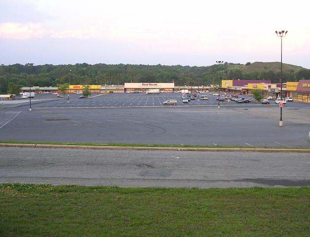
5 Characteristics of Commercial Corridors Spread out/low density Single-use/auto-oriented No sidewalks or landscaping Lots of signs Big parking lots Little or no public transportation Frequent congestion Cheap, cookie-cutter architecture
6 Corridor Redevelopment: Not a New Issue The effect of lax highway zoning is to create road towns, instead of centers with no beginning and no ending. Such development does not meet the conception of a true town. Benton MacKaye, 1930

7 Ten Principles for Reinventing Suburban Strips 1. Ignite leadership & nurture partnerships 2. Anticipate evolution 3. Know the market 4. Prune back retail-zoned Land 5. Establish pulse nodes of development 6. Tame the traffic 7. Create the place 8. Diversify the character 9. Eradicate the ugliness 10. Put your money(and regulations) where your policy is
8 Historic Approaches to Corridor Enhancement Retain Vehicular Focus and Beautify (Landscaping, signage, façade improvements) Balance between Vehicles and Pedestrians (Sidewalks, street furniture, cross walks, plus above) Manage vehicles and & Focus on Pedestrians (zoning adjustments, incentivize mixed uses & increased density. Traffic calming & transit upgrades Redevelopment (A new vision & complete makeover might include road reconfiguration, private site clearance, lots of new construction, connections to neighborhoods, a new image. Infill Redevelopment (A variation of the above, with new infill on a smaller scale)

9 Eight Steps for Reshaping the Strip 1. Put a limit on the length of any commercial district. 2. Limit curb cuts and consolidate entrances. 3. Unify the streetscape with street trees and landscaping. 4. Build sidewalks and crosswalks 5. Create a street frontage. 6. Provide incentives. 7. Encourage a mix of uses. 8. Eradicate the ugliness.
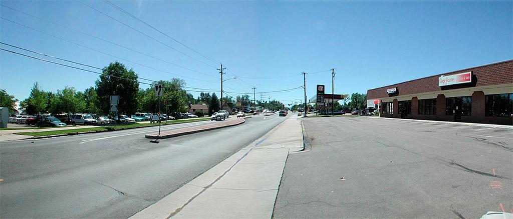
10 Existing Conditions
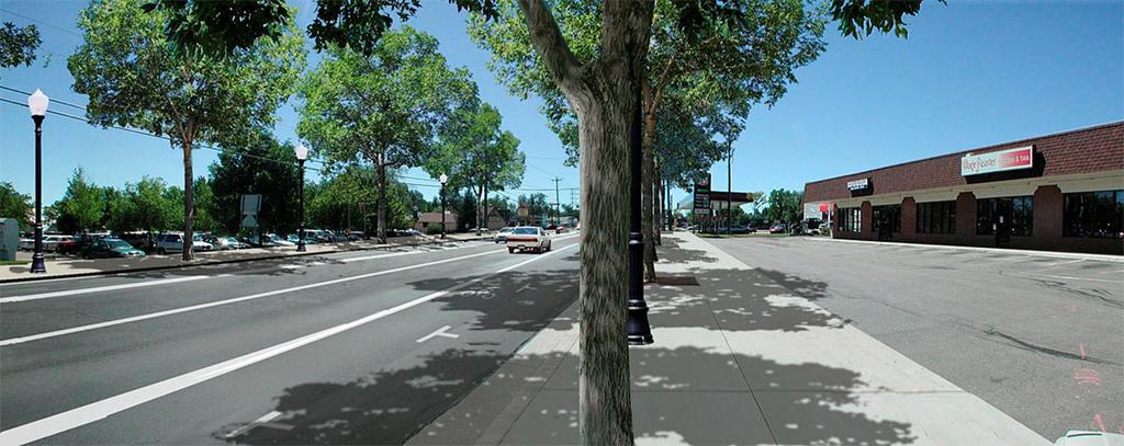
11 Infrastructure Improvements
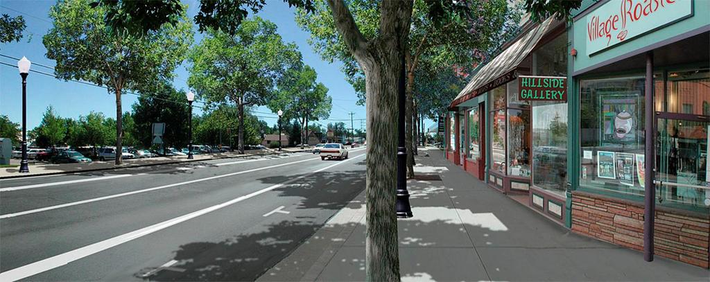
12 Private Investments

13 More Vibrant & Healthy Community


14 Walkability = Low Cost Health Care Walking is a miracle drug US Surgeon General has asked communities to build trails. President s Council on Physical Fitness build more trails.

15 Healthy Places Create Real Estate Value Numerous studies show that the demand for walkable, mixed use design far outstrips current supply There is a growing demand for small town/village/urban living especially among retirees, empty nesters, young professionals and single people.

16 Walkability Boosts Value & Health Walk Score is a walkability index assigned to a particular address. Carol Coletta, CEO s for Cities says each additional Walk Score point increases housing prices $600 to $3000. CDC says each 10 point increase in Walk Score results in 16 minutes per day more walking.

17 Bicycling is Booming!
18 Why Bike? For Better Health For Recreation For Transportation To Save money To Run Errands To Get to School
19 Bicycle Economics The US bicycle industry sold $6.1 billion in bicycles and equipment in 2014 In 2002 there were 7 bike share systems world wide. Today there are 750 In 2014, Americans bought more bikes (18 million) than cars & trucks (16.8 million) Bicycle infrastructure is cheap, particularly compared to motor-vehicle infrastructure. Portland has created a 300 mile network of bike trails, bike lanes and bike boulevards for about the same cost ($60 million) as one-mile of 4 lane urban freeway
20 Bicycling & Retail Sales Installing a mile long protected bike lane on Ninth Avenue in New York City resulted in an estimated 49% increase in retail sales among merchants located along the route. And a 58% reduction in injuries to all street users(cyclists, pedestrians, & drivers) Source: NYC Dept. of Transportation, Measuring the Street, 2012

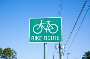
21 Basic Bicycle Infrastructure Bicycle Routes Bicycle Lanes Bike Trails

22 Protected Bike Lanes


23 Bicycle Boulevards A bicycle boulevard is low traffic neighborhood street that has been optimized for bicycling. This is accomplished through traffic calming measures and special signage. Bike Blvds. are extremely safe and welcoming to kids, families and novice cyclists.

24 Bicycle Roundabouts

25 Bicycle Friendly Community Enforcement Education Engineering Encouragement Evaluation

26 Corridor Retrofits Face Impediments Street standards Euclidean zoning Mandatory setbacks Road networks (arterials & collectors vs. street networks) Rules that favor traffic flow over pedestrians & connectivity Stormwater regulations Fear of change


27 We re Overbuilt on the Strip Ten fold increase in retail space from From 4 to 38 square feet per person. US has more than double the retail space per person as Europe. There is now more than 1billion square feet of vacant retail space (mostly in empty big box stores)

28 Retail space grew 5X faster than retail sales

29 Corridors Are Being Redesigned The largest retail trend of the next generation will be the conversion of dead or dying strip commercial centers in the suburbs into walkable urban places. Source: Chris Leinberger, The Brookings Institution
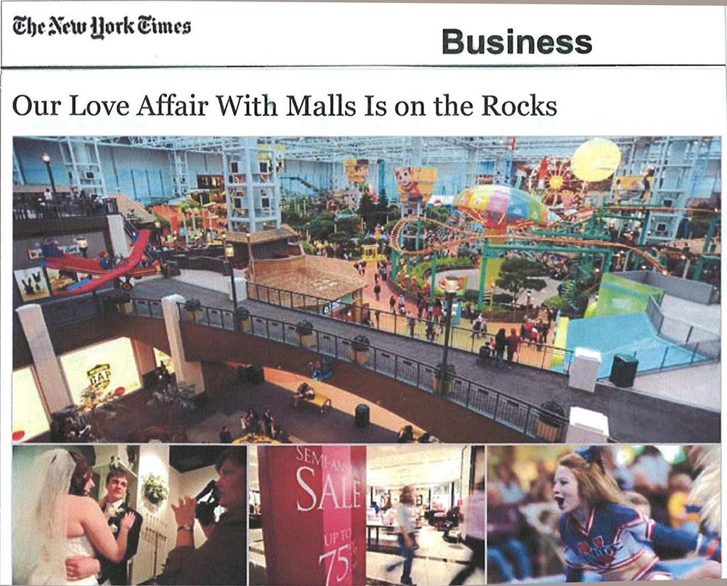
30

31 No new malls, since % of existing malls have closed 30% of existing malls being repositioned 1 Billion square feet of vacant retail space
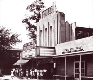
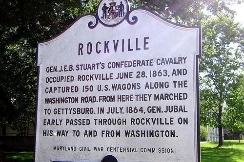
32 Downtown Rockville, MD Mostly demolished in 1970

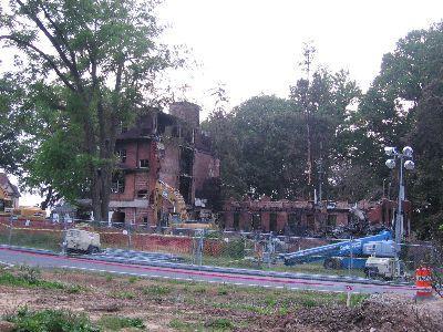
33 Downtown Replaced by Rockville Mall

34 Mall Replaced by Rockville Town Center

35 The Opportunity The New Promised Land?
36 Tear Up Parking Lot, Rebuild Paradise Large, flat, well drained site Major infrastructure in place 4 lane highway frontage, transit ready Saves rural land Committed to mixed use Can turn NIMBY s into YIMBY s 2.8 million acres of greyfields will be available in next 15 years

37 We Can Have This: Spread Out Single Use Drivable Only

38 Or This! Compact Mixed-Use Walkable

39 Barnes & Noble Rockville Pike One story Single use Lots of parking in front

40 Barnes & Noble Bethesda Row Multi-Story Mixed Use neighborhood No Parking in front


41 Which one is more profitable? 1 Way to get here: Drive your car Rockville Pike 4 Ways to get here Drive your car Take Metro Ride your bike Walk Downtown Bethesda


42 Waffle House Which one makes more money? Strip Waffle House Located next to Interstate Lots of Parking No housing nearby Downtown Waffle House Located on walkable street No dedicated Parking Housing upstairs
43 Walkable Waffle House outperforms Strip Waffle House by 15% Source: City of Fayetteville and ISR Working Group September 22, 2011 The downtown, mixed use project also produces: More taxes per acre More jobs per acre More residents per acre More people walking to and from the restaurant

44 Place Making Dividend People stay longer, come back more often and spend more money in places that attract their affection.

45 Charlotte Avenue is a Gateway to Downtown Nashville XXXXXXXXXXXXX
Table #6 VISION CHARACTERISTICS
 Table #6 VISION White Flint is a place to live, work, play, shop, and walk with sufficient density to encourage quality redevelopment. Vibrant streets and consistent streetscapes are important. CHARACTERISTICS
Illustrated Principles of Good Planning
 Illustrated Principles of Good Planning The Miami 21 Zoning Code incorporates time-tested planning principles into the zoning regulations of our City. These are principles that make for better neighborhoods,
Tourists simply won t go to a city or town that has lost its soul. Arthur Frommer
 Among cities and towns with no particular recreational appeal, those that preserve the past continue to enjoy tourism. Those that haven t receive almost no tourism at all. Tourists simply won t go to a
DALLAS MIDTOWN REDEVELOPMENT PLAN FOCUS NORTH TEXAS Peer Chacko, AICP, Assistant Director, City of Dallas
 DALLAS MIDTOWN REDEVELOPMENT PLAN FOCUS NORTH TEXAS 2014 Peer Chacko, AICP, Assistant Director, City of Dallas Dallas Midtown: Strategic growth area Future transit node 2 Peterson Road Study Area Galleria
A CHANGING CITY. of Edmonton, it is essential that it reflects the long-term vision of the City.
 A CHANGING CITY By the year 2040, Edmonton will be home to more than 1 million people. To accommodate growth and support a healthy and compact city, we need a new approach to development/redevelopment
Bicycle and Pedestrian Advisory Committee (BPAC) November 21, 2013
 November 21, 2013") Bicycle and Pedestrian Advisory Committee (BPAC) November 21, 2013 OVERALL LAND USE CONCEPT Overall Broadway Valdez District: 95.5 acres (35.1 acres right-of ways + 60.4 acres developable land) Plan Subareas:
Bicycle and Pedestrian Advisory Committee (BPAC) November 21, 2013 OVERALL LAND USE CONCEPT Overall Broadway Valdez District: 95.5 acres (35.1 acres right-of ways + 60.4 acres developable land) Plan Subareas:
5 CIRCULATION AND STREET DESIGN
 5 CIRCULATION AND STREET DESIGN This chapter describes circulation and streetscape improvements proposed for the Northwest Chico Specific Plan Area. It includes detailed design specifications for existing
CITY OF BLOOMINGTON COMPLETE STREETS POLICY
 CITY OF BLOOMINGTON COMPLETE STREETS POLICY POLICY OBJECTIVE: The City of Bloomington will enhance safety, mobility, accessibility and convenience for transportation network users of all ages and abilities,
Community Improvement Plans: Creating walkable and liveable communities that support local business
 Community Improvement Plans: Creating walkable and liveable communities that support local business Kate Hall Program Manager ~ WALK Friendly Ontario Canada Walks, Green Communities Canada khall@greencommunitiescanada.org
How to Develop a Pedestrian Safety Action Plan
 How to Develop a Pedestrian Safety Action Plan Course Introduction Presented by: Peter Eun FHWA RC Safety Engineer Ryan Snyder President, Ryan Snyder Associates, LLC Paul Zykofsky Director, Land Use and
Linking Transportation and Health in Nashville & Middle Tennessee
 Linking Transportation and Health in Nashville & Middle Tennessee Fit Nation New Orleans CPPW Mentoring Grant Built Environment Program May 14, 2011 Local Transportation Planning Framework Federal U.S.
Omaha s Complete Streets Policy
 Omaha s Complete Streets Policy (Adopted August 2015) VISION To create great places and enhance our quality of life, the City of Omaha will provide safe, accessible streets for all users. Complete Streets
2015 Florida Main Street Annual Conference. Complete Streets Equal Stronger Main Streets
 WHAT ARE COMPLETE STREETS? CASE STUDIES COMPLETING YOUR MAIN STREET 2015 Florida Main Street Annual Conference St. Petersburg, Florida August 19, 2015 WHAT ARE COMPLETE STREETS? CASE STUDIES COMPLETING
CONNECTIVITY PLAN. Adopted December 5, 2017 City of Virginia Beach
 CONNECTIVITY PLAN Adopted December 5, 2017 City of Virginia Beach CONTENTS 1.0 Background & Purpose... 2 2.0 Existing Inventory & Analysis... 3 ViBe District Existing Walking Conditions... 4 3.0 ViBe District
COWETA HIGH SCHOOL AND EAST HIGHWAY 51
 COWETA HIGH SCHOOL AND EAST HIGHWAY 51 Lack of sidewalks along Ben Lumpkin Rd. Lack of crosswalks and ramps at intersection. Hwy 51 is wide to cross as a pedestrian. No ADA compliance or connection to
Make Lincoln Highway an economically vibrant corridor that is safe, efficient, and beautiful for local residents and visitors.
 Lincoln Highway Streetscape Plan Stakeholder Workshop #2 Handout Contents Introduction and Project Vision Planning Principles Specific Recommendations including a Proposed Typical Roadway Section Renderings
o n - m o t o r i z e d transportation is an overlooked element that can greatly enhance the overall quality of life for the community s residents.
 N o n - m o t o r i z e d transportation is an overlooked element that can greatly enhance the overall quality of life for the community s residents. 84 Transportation CHAPTER 11 INTRODUCTION Transportation
PRINCE GEORGE S PLAZA METRO AREA PEDESTRIAN PLAN
 PRINCE GEORGE S PLAZA METRO AREA PEDESTRIAN PLAN May 28, 2008 Agenda Welcome and introductions Project overview and issue identification Planning context and strengths Design challenges and initial recommendations
What s Health Got to Do With It? Health and Land Use Planning
 What s Health Got to Do With It? Health and Land Use Planning CANDACE RUTT, PH.D. EXECUTIVE DIRECTOR APRIL 13 TH, 2016 Planning and Public Health Planning + Public Health Healthy Communities Healthier
STONY PLAIN ROAD STREETSCAPE
 Jasper Place Revitalization Strategy: Vision The people involved in the Jasper Place Revitalization Strategy envision: Goal 1: Feeling safe in our community Create a community where feeling safe is common--where
Designing for Pedestrian Safety
 Designing for Pedestrian Safety Introduction to Pedestrian Safety Design and Planning Principles Presented by: Craig Allred FHWA Resource Center Technical Specialist and Michael Ronkin Owner, Designing
Las Tunas Downtown Revitalization City Council Study Session. December 1, :00 p.m. Live Oak Park Community Center
 Las Tunas Downtown Revitalization City Council Study Session December 1, 2015 7:00 p.m. Live Oak Park Community Center AGENDA 2 Provide downtown context. Confirm project goals. Analyze three design concepts.
7 Complete Streets & Roadway Aesthetics
 7 Complete Streets & Roadway Aesthetics 7.1 OVERVIEW Our streets lay the foundation for how we interface with travel needs, physical exercise, social exchanges and access to goods and services. They are
5 Circulation & Parking
 5 Circulation & Parking Downtown Parking & Circulation Strategy. Downtown Wayne has a somewhat disconnected system of local public streets to connect downtown with the residential neighborhoods, and primary
summary of issues and opportunities
 1 summary of issues and opportunities EXECUTIVE SUMMARY CHAPTER 2: HISTORY - 3: LAND USE This first chapter is an overview of lessons learned from analysis of the existing conditions on El Camino as well
San Jose Transportation Policy
 San Jose Transportation Policy Protected Intersections in LOS Policies to Support Smart Growth Presented by: Manuel Pineda City of San Jose Department of Transportation Bay Area Map San Francisco Oakland
Mainstreet Master Plan Land Use
 Mainstreet Master Plan 04 Land Use Top Recommendations Active Uses: Promote active ground-floor uses such as retail, restaurants, galleries and personal services with interactive storefronts for Mainstreet
Ocean Park Boulevard Green Street Project Alternatives & Trade Offs
 Planning Commission March 4, 2009 Ocean Park Boulevard Green Street Project Alternatives & Trade Offs Purpose of Tonight s Meeting Review concept plans and options Provide input on alternatives and trade-offs
CENTENNIAL NEIGHBOURHOODS SECONDARY PLAN STUDY CITY OF HAMILTON SPECIFIC MAP COMMENTS FROM DECEMBER 1st PUBLIC INFORMATION CENTRE #2
 OPTION #2 - MIXED USE MEDIUM DENSITY OPTION #3 - MIXED USE MEDIUM AND HIGH DENSITY Look at other uses besides industrial along Barton Street over the long term. Residential facing waterfront over long
York Boulevard Streetscape Master Plan
 York Boulevard Streetscape Master Plan October 24 th, 2008 The Story of York Boulevard Streetscape Master Plan Design. Chapter 126 Dealing with Engineers. 2 1 Today s Presentation Topics: 1. Show the streetscape
Tonight is for you. Learn everything you can. Share all your ideas.
 Strathcona Neighbourhood Renewal Draft Concept Design Tonight is for you. Learn everything you can. Share all your ideas. What is Neighbourhood Renewal? Creating a design with you for your neighbourhood.
CONTEXT SENSITIVE STREETS STANDARDS COMMITTEE
 CONTEXT SENSITIVE STREETS STANDARDS COMMITTEE February 23, 2015 Prepared by: Denise Chaplick, AICP City Jacksonville Bicycle and Pedestrian Coordinator Source: NCDOT Complete Streets Planning and Design
complete streets design and construction standards public primer City of Edmonton
 complete streets design and construction standards public primer City of Edmonton introduction Complete Streets are streets for everyone: people who walk, wheel, bike, take transit, or drive. They are
Bicycle Transportation Budget Plan: Lawrence, KS
 Bicycle Transportation Budget Plan: Lawrence, KS Bicycle Objectives Lawrence Planning Documents Establish a dedicated funding plan to complete the implementation of a bikeway system plan, and for maintenance
DES MOINES AREA MPO. Presentation to Iowa Commercial Real Estate Association. April 6, 2017
 DES MOINES AREA MPO Presentation to Iowa Commercial Real Estate Association April 6, 2017 Presentation Outline MPO Overview Trends We re Watching Plans, Projects, Initiatives, Regional Transportation Priorities
REGIONAL BICYCLE AND PEDESTRIAN DESIGN GUIDELINES
 REGIONAL BICYCLE AND PEDESTRIAN DESIGN GUIDELINES November 16, 2011 Deb Humphreys North Central Texas Council of Governments Bicycle and Pedestrian Advisory Committee Snapshot of the Guide 1. Introduction
CASE STUDY WALKABLE WASHINGTON WHO WE ARE & WHAT WE DO CITY OF BOTHELL DOWNTOWN REVITALIZATION PLAN BOTHELL, WA
 LKABLE SHNGTON Transformation towards walkability is taking place all over the state of Washington. From urban, suburban and small town initiatives, the program showcases the effects of a renewed focus
Vision: Traditional hamlet with an attractive business/pedestrian friendly main street connected to adjacent walkable neighborhoods
 N D. Focus Area II Vision: Traditional hamlet with an attractive business/pedestrian friendly main street connected to adjacent walkable neighborhoods Transit Road Focus Area II is located in the Hamlet
Land Use and Transportation Town Hall September 17, 2018
 Land Use and Transportation Town Hall September 17, 2018 Welcome! Tonight s Agenda: 7:00-7:30 OVERVIEW PRESENTATIONS 7:30-8:15 BREAKOUT SESSIONS 8:15 - End TOWN HALL CITIZEN S TIME Purpose of Tonight s
Ajax: The Road to Complete Streets
 Ajax: The Road to Complete Streets Hubert Ng, Senior Transportation Planner Elysia Leung, Transportation Demand Management Coordinator Complete Streets Forum October 1, 2015 Overview 1 2 Introduction to
Lincoln Neighborhood Corridor Plan The LiNC
 CITY OF SANTA MONICA Lincoln Neighborhood Corridor Plan The LiNC PLANNING COMMISSION September 2, 2015 COMMUNITY DESIGN + ARCHITECTURE TEAM: Community Design + Architecture Iteris Studio 111 Urban Place
Ann Arbor Downtown Street Plan
 1 Ann Arbor Downtown Street Plan Public Workshop #1 We know that. 2 Public right-of-way (streets, sidewalks, and alleys) make up 30% of the total District area of downtown. Streets need to provide mobility
Active Community Design: Why Here? Why Now?
 Active Community Design: Why Here? Why Now? Chris Holm Development Review Coordinator 20 April, 2015 Sacramento, California Our environment has changed North Natomas We ve rapidly urbanize our open space
City of Novi Non-Motorized Master Plan 2011 Executive Summary
 City of Novi Non-Motorized Master Plan 2011 Executive Summary Prepared by: February 28, 2011 Why Plan? Encouraging healthy, active lifestyles through pathway and sidewalk connectivity has been a focus
West Dimond Blvd Upgrade Jodhpur Street to Sand Lake Road
 West Dimond Blvd Jodhpur St to Sand Lake CSS Transportation Project Summary Municipality of Anchorage Project # 05 005 Project Manager: John Smith, P.E. (MOA PM&E) Project Administrator: Julie Makela,
Living Streets Policy
 Living Streets Policy Introduction Living streets balance the needs of motorists, bicyclists, pedestrians and transit riders in ways that promote safety and convenience, enhance community identity, create
Thank you for this opportunity to discuss with you how we can work together to make our streets more complete.
 Thank you for this opportunity to discuss with you how we can work together to make our streets more complete. 1 2 3 Thank you for this opportunity to discuss with you how we can work together to make
Proposed White Flint Separated Bike Lane Network September 2015
 Proposed White Flint Separated Bike Lane Network September 2015 Abstract This report includes a proposed separated bike lane network for the White Flint Sector Plan area. Separated bike lanes create a
Perryville TOD and Greenway Plan
 Perryville TOD and Greenway Plan Greenway Glossary Pathway: A bicycle and pedestrian path separated from motorized vehicular traffic by an open space, barrier or curb. Multi-use paths may be within the
Agenda. Overview PRINCE GEORGE S PLAZA METRO AREA PEDESTRIAN PLAN
 PRINCE GEORGE S PLAZA METRO AREA PEDESTRIAN PLAN May 28, 2008 Agenda Welcome and introductions Project overview and issue identification Planning context and strengths Design challenges and initial recommendations
Plant City Walk-Bike Plan
 Plant City Walk-Bike Plan Plant City Commute Mode Share 2.2% 1.4% 2.9% Drove alone 10.2% Carpooled Public transportation (0.1%) Walked Used a Bike (0.4%) 82.9% Taxicab, motorcycle, or other means Worked
Implementing Complete Streets: The Road Diet. Ed McKinney, AICP Senior Associate, Glatting Jackson
 Implementing Complete Streets: The Road Diet Ed McKinney, AICP Senior Associate, Glatting Jackson How do we implement complete streets on our existing roads? Many Roads Could Use a road diet Trying to
NEWMARKET UPHAM S CORNER
 SOUTH STATION Planning Initiative NEWMARKET UPHAM S CORNER COLUMBIA ROAD (P) FOUR CORNERS/GENEVA Working Advisory Group (WAG) Meeting #5 TALBOT AVENUE MORTON STREET BLUE HILL AVE/CUMMINS HWY (P) RIVER
Route 7 Corridor Study
 Route 7 Corridor Study Executive Summary Study Area The following report analyzes a segment of the Virginia State Route 7 corridor. The corridor study area, spanning over 5 miles in length, is a multi
INNER LOOP EAST. AIA Rochester Annual Meeting November 13, 2013 TRANSFORMATION PROJECT. Bret Garwood, NBD Erik Frisch, DES
 INNER LOOP EAST TRANSFORMATION PROJECT AIA Rochester Annual Meeting November 13, 2013 Bret Garwood, NBD Erik Frisch, DES Why? We are building a city that encourages walking, biking and enjoying the outdoor
Cherry Creek Transportation and Land Use Forum September 25, 2013 Meeting Summary
 Cherry Creek Transportation and Land Use Forum September 25, 2013 Meeting Summary I. LEAD-IN TO SMALL GROUP DISCUSSION, POLLING AND STEERING COMMITTEE/TECHNICAL TASK FORCE DISCUSSION The meeting began
TORONTO WALKING STRATEGY
 CITY OF TORONTO t TORONTO WALKING STRATEGY EVERYONE IS A PEDESTRIAN ItitiORONM TORONTO MAYOR DAVID MILLER Toronto's Walking Strategy is a vision for a more liveable, prosperous and sustainable city. It
ANGLE LAKE DISTRICT STATION AREA PLAN
 SCHOOL ANGLE LAKE DISTRICT STATION AREA PLAN ADOPTED JULY 2015 TABLE OF CONTENTS Introduction... 1 Existing Conditions... 4 Economic Opportunity... 15 Community Vision... 18 Urban Design Framework... 22
Prince George s County plans, policies, and projects
 Prince George s County plans, policies, and projects Over 250 projects for trails, bikeways, designated bike lanes and sidewalk construction Trail projects that improve access to Metro Sidewalk and trail
Classification Criteria
 SCHEDULE D TO RECOMMENDED OFFICIAL PLAN AMENDMENT NO. 40 SCHEDULE C-4 Road Criteria Criteria Traffic Service Objective Land Service/Access Typical Daily Traffic Volume Flow characteristics Travel Speed
Multimodal Through Corridors and Placemaking Corridors
 68 Multimodal Through Corridors and Placemaking Corridors Corridors have different functions in a region. Some corridors are used to get smoothly and rapidly through a region or to get quickly to major
About the Active Transportation Alliance
 About the Active Transportation Alliance Chicagoland s voice for better biking, walking and transit Founded 1985 7,000 members, ~33 full time staff Serve Chicago metro region 1 More Cars, More Driving
Speed Limits Study and Proposal. Public Input Session: 8/14/13
 Speed Limits Study and Proposal Public Input Session: 8/14/13 Why is Decatur a unique place for this project? First Community Transportation Plan in the nation with a Health Impact Assessment. Strong sense
How To Encourage More Efficient Transportation in Brazilian Cities
 How To Encourage More Efficient Transportation in Brazilian Cities Todd Litman Victoria Transport Policy Institute Presented Seminar on Discouraging The Use Of Cars São Paulo, Brazil 3 September 2013 Creating
Exhibit 1 PLANNING COMMISSION AGENDA ITEM
 Exhibit 1 PLANNING COMMISSION AGENDA ITEM Project Name: Grand Junction Circulation Plan Grand Junction Complete Streets Policy Applicant: City of Grand Junction Representative: David Thornton Address:
Chapter 7. Transportation. Transportation Road Network Plan Transit Cyclists Pedestrians Multi-Use and Equestrian Trails
 Chapter 7 Transportation Transportation Road Network Plan Transit Cyclists Pedestrians Multi-Use and Equestrian Trails 7.1 TRANSPORTATION BACKGROUND The District of Maple Ridge faces a number of unique
Rock Spring Kick-Off Meeting 09/01/15 Walter Johnson High School Break Out Table Summaries. Rock Spring Break Out Table Comments. Table 1: Strengths:
 Rock Spring Break Out Table Comments Table 1: Strengths: Trees, open areas 1 Medical Care, Offices Parking at Medical important Mall access Good access to emergency services/police/ambulance/fire Weaknesses:
Complete Streets Successes, Opportunities, and Challenges
 Complete Streets Successes, Opportunities, and Challenges Juliet Walker, Transportation Planner, City of Portsmouth Rob Houseman, Director of Planning and Development, Town of Wolfeboro Chris Parker, Director
CML s 91 st Annual Conference June 18 21, 2013 Vail, Colorado. Why a Campaign? Learn More. City of Brush! 6/13/2013
 REVITALI ZE Your Community with LiveWell Colorado s HEAL Cities & Towns Campaign CML s 91 st Annual Conference June 18 21, 2013 Vail, Colorado Vicky Quinlin, Council Member, Brush! Monty Torres, City Administrator,
TRANSPORTATION NEEDS ASSESSMENT
 TRANSPORTATION NEEDS ASSESSMENT A travel demand analysis was carried out to determine the operational issues and the potential benefit that adding traffic capacity would have on the road network. All the
Approaches. Livable Neighborhood Design. Examples. Traditional neighborhood development. CE 594 University of Wisconsin- Milwaukee
 Approaches Livable Neighborhood Design CE 594 University of Wisconsin- Milwaukee Traditional neighborhood design (TND), new urbanism, transit friendly design, transit oriented development and walkable
EXECUTIVE SUMMARY: TRANSIT-ORIENTED DEVELOPMENT IN SMITHS FALLS, ONTARIO; A COMPARISON BETWEEN TWO SITES
 EECUTIVE SUMMARY: TRANSIT-ORIENTED DEVELOPMENT IN SMITHS FALLS, ONTARIO; A COMPARISON BETWEEN TWO SITES Topic and Purpose In 2007, the Mayor of Ottawa s Task Force on Transportation suggested adding a
TOWN OF WILLIAMSTON, SC BICYCLE AND PEDESTRIAN MASTER PLAN TOWN OF WILLIAMSTON, SC BICYCLE AND PEDESTRIAN MASTER PLAN
 TOWN OF WILLIAMSTON, SC BICYCLE AND PEDESTRIAN MASTER PLAN Americans Want Choices 55% of Americans would rather drive less & walk more. Transit use is growing faster than population or highway travel.
MIXED USE AND STREETSCAPE INTEGRATION Avondale Will Basil Juliana Zannotto
 MIXED USE AND STREETSCAPE INTEGRATION Avondale Will Basil Juliana Zannotto Creating new development so that people will stop and see what Avondale has to offer The goal for my project was simple. I wanted
INDEX. Geometric Design Guide for Canadian Roads INDEX
 Acceleration lane, see Lanes, Acceleration Access, 8.1 Access Management and Functional Classification 8.2 Access Management by Design Classification 8.3 Access Configuration 8.4 Building Set-Back Guidelines
City of Wausau Wausau Center Urban Design and Transportation Master Plan. Design Workshop // October 18, 2018
 City of Wausau Wausau Center Urban Design and Transportation Master Plan Design Workshop // October 18, 2018 Design Workshops // October 15-18 Workshop Study Evaluate circulation and parking patterns around
Chapter 5 Future Transportation
 Chapter 5 Future Transportation The Future Land Use Plan identifies the desired land use designations. The land uses desired for Crozet depend, in large part, on the success of the transportation system,
FOCUS AREA 1 - Alberta Avenue Pocket Park 3 (121 Ave and 92 St)
") FOCUS AREA 1 - Alberta Avenue Pocket Park 3 (121 Ave and 92 St) New benches Plant evergreen trees Widen existing sidewalk from 1.5m to 1.8m Marked crosswalk 1.8m wide sidewalk Add pedestrian oriented lights
FOCUS AREA 1 - Alberta Avenue Pocket Park 3 (121 Ave and 92 St) New benches Plant evergreen trees Widen existing sidewalk from 1.5m to 1.8m Marked crosswalk 1.8m wide sidewalk Add pedestrian oriented lights
Thesis Presentation. Moorhead City Walk: A Master Plan to Reimage Moorhead, Minnesota s Urban Core. Brad Garcia Advisors: Jason Kost & Dominic Fischer
 Thesis Presentation Moorhead City Walk: A Master Plan to Reimage Moorhead, Minnesota s Urban Core Brad Garcia Advisors: Jason Kost & Dominic Fischer MOORHEAD, MN Red River Center Ave 8 TH St N FARGO, ND
What Is a Complete Street?
 Session 5 Charleen Zimmer, AICP, Zan Associates May 5-7, 2010 What Is a Complete Street? May 2010 5-1 Not a Complete Street More of a Complete Street May 2010 5-2 Benefits of Complete Streets Safety for
Presentation Starts at 5:30 PM
 Presentation Starts at 5:30 PM Public Meeting #1 September 22, 2016 Purpose of Study Conceptual Complete Streets Study on South Carson Street 5 th Street to Roland Drive Approximately 2.5 miles Consider
Introduction. Who is WILMAPCO. Why are walkable communities important
 Walkable Community Workshops Round 1 April 2005 SPONSORED BY WILMAPCO AND CCOBH CITY OF NEW CASTLE EDGEMOOR GARDENS CIVIC ASSOCIATION WITH FUNDING BY DELAWARE DEPARTMENT OF TRANSPORTATION AND THE DELAWARE
2016 I-30 CROSSING ARKANSAS BOULEVARD KEY IDEAS OF PLAN B:
 KEY IDEAS OF PLAN B: Transportation shall support all parts of the cities and improve the quality of life downtown. There is no need to shorten commuting time at rush hour by a few minutes at the risk
Smart Growth, Climate Change and Prosperity Steve Winkelman Chuck Kooshian
 Smart Growth, Climate Change and Prosperity Steve Winkelman Chuck Kooshian Asilomar Transportation & Energy Conference August 31, 2011 CCAP put the third leg of the stool on the policy map. Reducing VMT
SETTINGS AND OPPORTUNITIES MOBILITY & ACCESS
 7 mobility & access how do people use el camino what is it like to drive on el camino/to park along el camino what is the pedestrian experience like what is the role of transit along the corridor what
Building a Liveable Ottawa 2031 Backgrounder 4: Kanata/Stittsville
 Building a Liveable Ottawa 2031 Backgrounder 4: Kanata/Stittsville Wards 4, 6 and 23 Official Plan Transportation Master Plan Cycling Plan Pedestrian Plan October 2013 ottawa.ca/liveableottawa Building
Complete Streets: Planning, Policy & Performance
 Complete Streets: Planning, Policy & Performance Tell Us About Your CS Experiences Successes Hardships Funding Politics Safety Not every street needs to be complete, but every mode needs a complete network.
Executive Summary Route 30 Corridor Master Plan
 Route Corridor Master Plan Project Overview The Route Corridor Master Plan is a coordinated multimodal transportation and land use plan for the entire stretch of Route through East Whiteland Township,
Goodlettsville Bicycle and Pedestrian Plan Executive Summary
 Goodlettsville Bicycle and Pedestrian Plan July 2010 In Cooperation with the Nashville Area Metropolitan Planning Executive Organization Summary Introduction Progressive and forward thinking communities
Areas for Redevelopment or New Development:
 Small Group Exercise Summary Areas for Redevelopment or New Development: 1. Downtown a. Job Resource Center b. Community Activities / Activities to draw youth & millennials c. Need for additional parking
City of Atlanta-MARTA Sales Tax Referendum Draft Project List. Atlanta City Council Work Session May 19, 2016
 1 City of Atlanta-MARTA Sales Tax Referendum Draft Project List Atlanta City Council Work Session May 19, 2016 2 SB 369 - MARTA Sales tax for up to 0.50% is allowed in the City of Atlanta for MARTA Purpose
12/4/2016 VIA . RE: Grocery Outlet Del Paso (DR16-328)
") 12/4/2016 VIA EMAIL Ethan Meltzer, Assistant Planner City of Sacramento Community Development Department 300 Richards Blvd, 3 rd Floor Sacramento, CA 95811 RE: Grocery Outlet Del Paso (DR16-328) Dear Mr.
12/4/2016 VIA EMAIL Ethan Meltzer, Assistant Planner City of Sacramento Community Development Department 300 Richards Blvd, 3 rd Floor Sacramento, CA 95811 RE: Grocery Outlet Del Paso (DR16-328) Dear Mr.
RESOLUTION NO ?? A RESOLUTION OF THE CITY OF NEPTUNE BEACH ADOPTING A COMPLETE STREETS POLICY
 RESOLUTION NO. 2018-?? A RESOLUTION OF THE CITY OF NEPTUNE BEACH ADOPTING A COMPLETE STREETS POLICY WHEREAS, safe, convenient, and accessible transportation for all users is a priority of the City of Neptune
DRAFT - CITY OF MEDFORD TRANSPORTATION SYSTEM PLAN Roadway Cross-Sections
 Roadway Cross-Sections Medford s roadway cross-section standards apply to new and reconstructed roads. The crosssections take into consideration roadway function and operational characteristics, including
Prioritizing Transportation Policy and Funding for Active Transportation, Safety, Equity and Health
 Mayor Karl Dean, Chairman Prioritizing Transportation Policy and Funding for Active Transportation, Safety, Equity and Health Leslie A. Meehan, AICP Planning and Implementing the Active Community Webinar
CONNECTING PEOPLE TO PLACES
 CONNECTING PEOPLE TO PLACES 82 EAST BENCH MASTER PLAN 07 Introduction The East Bench transportation system is a collection of slow moving, treelined residential streets and major arteries that are the
TRANSPORTATION & MOBILITY
 TRANSPORTATION & MOBILITY ROADWAY SYSTEM There are approximately 40 miles of roadways in Manitou Springs. For planning purposes, roadways are typically assigned a functional classification which defines
Brian D. Hare, P.E. Bureau of Design PennDOT PA APA Annual Conference Investing in a Sustainable Future October 5, 2009
 Brian D. Hare, P.E. Bureau of Design PennDOT 2009 PA APA Annual Conference Investing in a Sustainable Future October 5, 2009 1 What is Smart Transportation? Photographer: heyjude. Used through license
Ocean Park Boulevard Streetscape Improvement Project Alternatives & Trade Offs
 City Council Study Session January 27, 2009 Ocean Park Boulevard Streetscape Improvement Project Alternatives & Trade Offs Scope of Work Purpose of Tonight s Meeting Review work to date and direct staff
Stakeholder Meeting Handouts. January 2013
 January 2013 Stakeholder Meeting Handouts The Case FOR Parking Minimum Requirements Reduce street congestion around the development site Avoid parking spillover Create orderly development patterns Anticipate