Lacey Pedestrian and Bicycle Plan Meeting Summary Notes Citizen s Advisory Committee Meeting #1
|
|
|
- Allen Bishop
- 5 years ago
- Views:
Transcription

1 Lacey Pedestrian and Bicycle Plan Meeting Summary Notes Citizen s Advisory Committee Meeting #1 September 27, 2017, 6:00 8:00 pm Attachments: Meeting Agenda Introductory Presentation Staff and Consultants present: Ryan Andrews, City of Lacey Planning Manager Martin Hoppe, Lacey City Traffic Engineer Scott Egger, Lacey Public Works Director Michael Hintze, Toole Design Group, Consultant Team Project Manager Julia Walton, 3 Square Blocks, Consultant Team Public Outreach Lead 1. Introductions Meeting attendees introduced themselves, mentioned a place where they enjoyed walking or biking and why. They also identified a key outcome that they would like to see from this plan. Jessica Gould, Walk N Roll Program, Intercity Transit. A bicycle commuter who likes walking and is interested in Safe Routes to Schools. Bill Spaulding, Capitol Volkssport Club. Avid walker and bicyclist. Would like to see improved standards for bike lanes, more connections across I5, better markings and expanded bike corridors. Brandon Stephens, Abbey Realty. He lives in an urban campus and would like to help facilitate bike commuter infrastructure. Chris Hawkins, Thurston County Public Health & Social Services, leader of the Thurston Thrives program; works to facilitate active living. Enjoys the Chehalis Western Trail. Austin, Texas is a good model with the connected trails along the river. Casey Wilson, Teacher, Nisqually Middle School, worked with Nisqually Walks. Highway 1 in Santa Cruz and McLean, NJ are example places. Goal is to improve school sidewalks strategy. Melissa Anderson, stay at home mom, interior design background includes healthy living. Would like to see Lacey improve bike and ped facilities enhanced not as an afterthought. The Spokane Trail is an example. Chuck Kennedy, Olympic Crest Coffee Roasters. Interested in business perspective along the Woodland Trail. 1
2 Cleo Pineda, St. Martin s University. Interested in the process of developing the plan and taking part in that process. Jeff Glass, Western Trail Association, substitute member for Jack Horton. Facilities Director at Providence SW Hospital. His mantra is healthy communities. Personal story is cycling in Europe with its commitment to mobility. Chazz Pope, Owner, Baby Boomer Bicycles. Works at JBLM and has a strong interest in bicycling. Paul Enns, Lacey Planning Commission member, Panorama City resident. Walks dogs and enjoys the Chehalis Western Trail. Not present: Berl Colley, Duncan Green. 2. Project Introduction Michael Hintze presented an overview of the Lacey Pedestrian & Bicycle Plan and asked the group to consider what would be their measures of success. This will be for the CAC to decide. There will be a Bike/Walk Audit conducted on Saturday, October 14, Ryan will send an invitation to the CAC members. All are encouraged to attend. Michael reviewed the project web page, interactive map and survey with the CAC; these are now live; CAC members are encouraged to access the web site and spread the word. Citizen Committee request: Can the City please identify existing planned City ped/bike improvements and whether there are any planned County ped/bike improvements in the UGA? 3. Group Existing Conditions Exercise Two groups were formed for an existing conditions exercise. The charge was to review and discuss the Existing Conditions Map and report on key discussion points and any other key points that the CAC would like for the project team to consider. Group 1 Report Out The area of Lacey that is south of Lacey Boulevard, north of the South Sound Center and east of the Chehalis Western Trail and west of the Lakes lacks bike and pedestrian infrastructure. Ideas for making connections to the Chehalis Western Trail include: piece together routes to the trail with signs and striping on low volume streets and mark/identify both as walking routes The group identified a new trail on the City perimeter using Britton Parkway and Willamette. Carpenter Road is one way to connect east/west to the Chehalis Western Trail. Steilacoom Road serves Nisqually Middle School/crosses the rail line near the Amtrak Station. Make better connections to the neighborhood where the Chehalis Western Trail ends. Look for places where short segment connections might be done with minor improvements. Learn from Olympia regarding Bicycle Streets There are opportunities to do an off road BMX Park in a detention area in Hawk s Prairie. A lot of kids and mountain bikes use that area now. 2

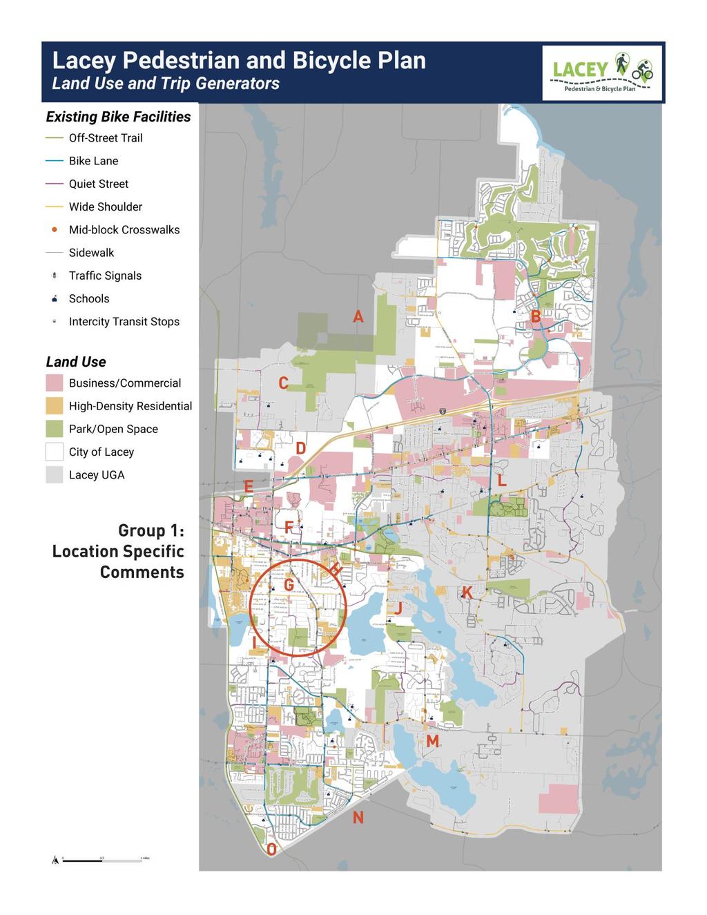
3 Group 1 General Comments from the Mapping Exercise: How can we increase connectivity across I-5? The only place I feel comfortable riding bikes with baby trailer or young riders is in residential or on trail but NOT on bike lanes. Sidewalks work with separation between road and sidewalk How do we know what is already being considered in other projects/committees? Could we get a definition of quiet street? Olympia has nice bike corridors that provide alternate routes. Those are attractive. How can those be added or considered? Older parts of Lacey what s the access like? 1950s era: no sidewalk standards, limited access Areas without sidewalks also often lack streetlights, especially in unincorporated areas How will City of Lacey coordinate with City of Olympia to increase connectivity? Fast growth in the Hawks Prairie area great incorporation of bike lanes Sidewalks to school 1-mile radius Group 1 Recommended Map Additions Add school names BMX Mt Bike Park Group 1 Location-Specific Comments (See map on the following page. Letters below are keyed to map locations): A. Plan trail into new land acquisition (Pleasant Glade Neighborhood Park) B. Need pedestrian cut through to commercial by Salish Middle C. Need sidewalk access for kids near Pleasant Glade School D. Bike lanes on college, If no bike lanes on college give extra feet to sidewalks since they are so narrow E. Better connection from I-5 bike path directly to SPSCC main campus F. Better signage helping people find trail or other facilities for walking or bicycling along the Chehalis Western and Woodland Trails G. Back entrance to school is blocked (MVES) H. Lack of on-street facilities though the core area of Lacey I. Need a connecting route from the Chambers Lake Nature Area/Stormwater facility to connect down to 37th and thereby create a loop (and better access) with the Chehalis Western Trail. J. Carpenter Road needs improving with wider shoulders and amenities K. Union Mills Rd sidewalk or bike lane 3
4 L. Steilacoom Road has very high speeds, no bike lane/sidewalks, please get county project done! It s stuck in environmental review! M. County project to improve shoulders, add sidewalk? (along Mullen Rd) N. Wider shoulder/bike lane needed to connect to Amtrak Station O. Need a better crossing of Rainier Rd. for residents of Horizon Pointe to get to the southbound Chehalis Western. 4
5 5

6 Group 2 Report Out Sidewalks are identified on the map in residential areas where they don t exist, i.e. Hawk s Prairie and Target Center. There are no sidewalks on Steilacoom Road between Pacific and Regional Athletic Center School/RAC recreation complex make connections Exit 111 overpass will become a Divergent Diamond Interchange (DDI). It s a choke point for walking and biking. Good recreational opportunity to extend the Lacey Woodland Trail-railroad no longer servicing the Old Box Plant. Connect Greg Cuoio Park to the Chehalis Western Trail and Sleater Kinney Road. Locate a rest stop in the school or parking lot at the south end of the Chehalis Western Trail. Put a trail overlook on 14 th Street where the trail goes over the road. Identify types of businesses for bike access such as grocery stores like the Safeway in the finger of Olympia, Safeway on Carpenter Road. Add Chehalis Western Trail access points in or through Panorama community, though there would be parking issues if people came in from the outside. Group 2 General Comments from the Mapping Exercise: Thurston Thrives has done inventory of trail access points (Chris Hawkins to share) Improve accessibility to Woodland Trail form businesses Group 2 Recommended Map Additions: Add bike lane between the north side of meridian park neighborhood and the sound Should map grocery store connections Trail connection and additional bike lanes through Pleasant Glade Neighborhood Park Extend Woodland Trail to McAllister Springs Existing access between neighborhood north of Chambers Lake and Westlake Dr. NE What is marked as a bus stop along Yelm Way is actually an Amtrak Station Restroom near the corner of Rainer Rd and 67 th Ave SE Group 2 Location-Specific Comments (See map on the following page. Letters below are keyed to map locations): A. Marvin Rd next to Target Warehouse need sidewalk on both sides of street B. Soon to be DD interchange, find WSDOT plans (Spruce and I-5) C. Footpath existing connecting 20 th Ave NE to trail on the western edge of the city 6
7 D. Note at the intersection of 7th Ave NE and 7 Sleater Kinney Rd: KM?
8 E. Narrow bridge, undercrossing (Westlake Dr SE and 14th Ave) F. No safe bike or pedestrian on gulf club south of Pacific to 26th G. No sidewalk along Steilacoom Rd between Spruce and School St H. BNSF no longer servicing railroad tracks along Union Mills Rd I. No man s land need plan for better infrastructure J. Mullen Rd near Marvin Rd intersection very challenging for bikes K. Bridge along Yelm Hwy is an issue in a long-terms plans to replace 4. Summary and Next Steps City of Lacey to the postcard out to CAC members. Is there a connection to be made between bike activity and economic development? Have we thought of: a Tour de Lacey, Brewery or Distillery District in Hawk s Prairie? The Health Department has access to trails system data and maps and will send that to Ryan. Expand map boundaries to east and west to show connectivity beyond City boundaries. 8
Walkability Audit Cities of Olympia, Tumwater and Lacey, Washington. Next Steps Memorandum September FINAL
 Walkability Audit Cities of Olympia, Tumwater and Lacey, Washington Memorandum September 2012 - FINAL 1. INTRODUCTION The U.S. Environmental Protection Agency (EPA) selected the Thurston Regional Planning
City of Wilsonville 5 th Street to Kinsman Road Extension Project
 City of Wilsonville 5 th Street to Kinsman Road Walking Tour & Neighborhood Workshop Summary Report Public Outreach Overview On July 18 th, 2017, the City of Wilsonville hosted a neighborhood walking tour
The Bike Buzz in Richland. November 2017 Carl Berkowitz
 The Bike Buzz in Richland November 2017 Carl Berkowitz Richland has been growing by leaps and bounds with lots of new homes and roads throughout the community. Recognizing all the growth in the Queensgate
Introduction. North 12 th Complete Street Project Overview
 Introduction On Wednesday, March 1, 2017, the City of Sacramento, in partnership with Sacramento Regional Transit District and the Sacramento Housing and Redevelopment Agency, hosted a community outreach
Bikeway action plan. Bicycle Friendly Community Workshop March 5, 2007 Rochester, MN
 Bikeway action plan Summary The was held on March 5, 2007 at the Rochester Mayo Civic Center. The workshop was hosted by Rochester-Olmsted County Planning Department in collaboration with the League of
CONNECTING PEOPLE TO PLACES
 CONNECTING PEOPLE TO PLACES 82 EAST BENCH MASTER PLAN 07 Introduction The East Bench transportation system is a collection of slow moving, treelined residential streets and major arteries that are the
MASTER BICYCLE AND PEDESTRIAN PLAN
 VILLAGE OF NORTHBROOK MASTER BICYCLE AND PEDESTRIAN PLAN DRAFT PLAN OPEN HOUSE May 2, 2018 AGENDA 1. Community Engagement 2. Vision and Goals 3. General Structure of Plan 4. Recommendations Overview 5.
Austin Avenue Bridges Project. Public Meeting Summary
 Austin Avenue Bridges Project Public Meeting Summary June 29, 2016 Red Table Safety and Connectivity Notes: 1. Would like to see forensic report evaluations 2. What is the lifespan? 3. Extend safety considerations
Annual Listing of Obligated MPO Projects
 Thurston Regional Planning Council Annual Listing of Obligated MPO Projects CY 2015 March, 2016 2424 Heritage Court SW, Suite A, Olympia, WA 98502 360.956.7575 www.trpc.org About TRPC, established in 1967,
CITY OF PORTSMOUTH PLANNING DEPARTMENT
 CITY OF PORTSMOUTH PLANNING DEPARTMENT MEMORANDUM TO: JOHN P. BOHENKO, CITY MANAGER FROM: JULIET T.H. WALKER, PLANNING DIRECTOR SUBJECT: BICYCLE / PEDESTRIAN PLAN PROGRESS UPDATE DATE: 3/13/2018 Background
City of Davis East Covell Corridor Plan
 Community Open House #2 January 22, 2014 6:00 8:00 p.m. Veterans Memorial Center, Club Room City of Davis Introduction The (ECCP) is a taking a comprehensive look at the existing transportation systems
PRINCE GEORGE S PLAZA METRO AREA PEDESTRIAN PLAN
 PRINCE GEORGE S PLAZA METRO AREA PEDESTRIAN PLAN May 28, 2008 Agenda Welcome and introductions Project overview and issue identification Planning context and strengths Design challenges and initial recommendations
2.0 Existing Conditions
 20 2.0 Existing Conditions 2.1 Land Use, Future Growth Patterns, Physical Barriers Geographic Overview Sutter County s land use pattern is characterized by extensive agricultural areas, significant natural
Lee s Summit Road Improvement Study Public Open House June 7, 2007 Summary of Comment Card Responses
 Lee s Summit Road Improvement Study Public Open House June 7, 2007 Summary of Comment Card Responses Introduction At the Lee s Summit Road Improvement Study Public Open House held Thursday, June 7, 2007
4. Mobility and Transportation Element. Page Bikes and Pedestrians
 Below are the specific General Plan text changes proposed for A-16-015 and the proposed changes to Figure MT-2 Paths and Trails. In general changes consist of removing references to the Bicycle, Pedestrian
Orinda Bicycle, Trails and Walkways Master Plan
 Orinda Bicycle, Trails and Walkways Master Plan Public Meeting October 15, 2008 Presented by: Ian Moore, Alta Lauren Ledbetter, Alta Bruce Wolff, Alta Introductions City of Orinda Monica Pacheco, Assistant
EXECUTIVE SUMMARY. Vision
 Vision Walking and bicycling in Salt Lake City will be safe, convenient, comfortable, and viable transportation options that connect people to places, foster recreational and economic development opportunities,
Chapter 5 Future Transportation
 Chapter 5 Future Transportation The Future Land Use Plan identifies the desired land use designations. The land uses desired for Crozet depend, in large part, on the success of the transportation system,
Safe Streets. City of Lake Forest Park. March 21, 2017
 Safe Streets City of Lake Forest Park March 21, 2017 1 01 WELCOME 2 Agenda WELCOME WHAT IS THIS PROJECT? CONTEXT DRAFT CITYWIDE PROJECTS EXERCISE INTRODUCTION 3 02 WHAT IS THIS PROJECT? 4 WHAT IS THIS
Walkability Audit Scores and Comments Lacey, Tumwater, and Olympia, WA September 2012
 Walkability Audit Scores and Comments Lacey, Tumwater, and Olympia, WA September 2012 The U.S. Environmental Protection Agency (EPA) provided technical assistance to Thurston Regional Planning Commission
COASTAL RAIL TRAIL ROSE CREEK BIKEWAY PROJECT COMMUNITY WORKSHOP #2 AUGUST 15, 2013
 COASTAL RAIL TRAIL ROSE CREEK BIKEWAY PROJECT COMMUNITY WORKSHOP #2 AUGUST 15, 2013 CHRIS CARTERETTE, AICP PROJECT MANAGER Chris.Carterette@sandag.org Direct: 619-699.7319 REGIONAL PLANNING BACKGROUND
CITY OF GRAND JUNCTION URBAN TRAILS COMMITTEE 2017 ANNUAL REPORT
 CITY OF GRAND JUNCTION URBAN TRAILS COMMITTEE 2017 ANNUAL REPORT INTRODUCTION INTRODUCTION Resolution No. 48 94 created the Grand Junction Trails Board in 1994 as a subcommittee of the Riverfront Commission
West Capitol Avenue Road Rehabilitation and Safety Enhancement Project
 West Capitol Avenue Road Rehabilitation and Safety Enhancement Project Stakeholder Focus Group Meeting #2 Tuesday, August 28, 2018 7:00 8:00 a.m. West Sacramento City Hall 1110 West Capitol Avenue, West
Tuesday, September 25 th Mount Holly Municipal Complex 400 East Central Avenue 5:30pm to 7:30pm. Activity Stations o Where do you Live?
 Meeting Information Overview The public workshop for the Mount Holly Comprehensive Bicycle Plan occurred on September 25, 2018. The drop-in workshop allowed attendees to participate in a series of interactive
TOWN OF WILLIAMSTON, SC BICYCLE AND PEDESTRIAN MASTER PLAN TOWN OF WILLIAMSTON, SC BICYCLE AND PEDESTRIAN MASTER PLAN
 TOWN OF WILLIAMSTON, SC BICYCLE AND PEDESTRIAN MASTER PLAN Americans Want Choices 55% of Americans would rather drive less & walk more. Transit use is growing faster than population or highway travel.
A Holistic Approach to Community Connectivity. 50 th International Making Cities Livable Conference Portland, OR June 2013
 A Holistic Approach to Community Connectivity 50 th International Making Cities Livable Conference Portland, OR June 2013 Founded 2008 About GP RED Research Education Advocacy Focus on Health, Recreation
Transportation Corridor Studies: Summary of Recommendations
 Transportation Corridor Studies: Summary of Recommendations Route 4 Corridor Study: Route 10 Corridor Study: Route 44 Corridor Study: Route 175 Corridor Study: Route 5/15 Corridor Study: Rentschler Field
Chapter 7 Nonmotorized Facilities
 Chapter 7 Nonmotorized Facilities What is in this chapter? This chapter discusses existing and proposed pedestrian and bicycle facilities referred to as nonmotorized facilities along the SR 520 corridor.
A Complete Streets Policy for Saratoga Springs. Presented By: Shared Access Saratoga
 A Complete Streets Policy for Saratoga Springs Presented By: Shared Access Saratoga April 17, 2012 Agenda 1. Introduction to Complete Streets (CS) 2. Shared Access Saratoga 3. Why is CS Important 4. What
US 19 PEDESTRIAN AND BICYCLE SAFE ACCESS
 US 19 PEDESTRIAN AND BICYCLE SAFE ACCESS TO TRANSIT CORRIDOR STUDY A JOINT EFFORT OF THE FLORIDA DEPARTMENT OF TRANSPORTATION AND FORWARD PINELLAS (F.K.A. PINELLAS COUNTY METROPOLITAN PLANNING ORGANIZATION)
CONNECTIVITY PLAN. Adopted December 5, 2017 City of Virginia Beach
 CONNECTIVITY PLAN Adopted December 5, 2017 City of Virginia Beach CONTENTS 1.0 Background & Purpose... 2 2.0 Existing Inventory & Analysis... 3 ViBe District Existing Walking Conditions... 4 3.0 ViBe District
Kingwood Area Mobility Study. Lake Houston Redevelopment Authority (TIRZ #10)
") Kingwood Area Mobility Study Lake Houston Redevelopment Authority (TIRZ #10) Steering Committee Meeting #3 Date: May 27, 2014 Introductions/Remarks Steering Committee Project/Consultant Team GOALS & MOE
Kingwood Area Mobility Study Lake Houston Redevelopment Authority (TIRZ #10) Steering Committee Meeting #3 Date: May 27, 2014 Introductions/Remarks Steering Committee Project/Consultant Team GOALS & MOE
Bluffdale/ UDOT South High-T Intersection Project Type Operations
 Bluffdale/ UDOT 14600 South High-T Intersection Project Type Operations 14600 South and Redwood Road $ 600,000 $ 550,000 This project is to install a new High-T intersection at Redwood Road and 14600 South
Agenda. Overview PRINCE GEORGE S PLAZA METRO AREA PEDESTRIAN PLAN
 PRINCE GEORGE S PLAZA METRO AREA PEDESTRIAN PLAN May 28, 2008 Agenda Welcome and introductions Project overview and issue identification Planning context and strengths Design challenges and initial recommendations
Beach Cities Living Streets Design Manual and Aviation Boulevard Multimodal Corridor Plan
 Beach Cities Living Streets Design Manual and Aviation Boulevard Multimodal Corridor Plan AGENDA 1 Introductions & Project Scope 2 Public Outreach Recap 3 Living Streets Design Manual 4 Aviation Boulevard
Solana Beach Comprehensive Active Transportation Strategy (CATS)
") Solana Beach Comprehensive Active Transportation Strategy (CATS) 3.0 Goals & Policies The Solana Beach CATS goals and objectives outlined below were largely drawn from the Solana Beach Circulation Element
Solana Beach Comprehensive Active Transportation Strategy (CATS) 3.0 Goals & Policies The Solana Beach CATS goals and objectives outlined below were largely drawn from the Solana Beach Circulation Element
Duwamish Way-finding and CTR Report
 V. North Tukwila When the North Tukwila Manufacturing and Industrial Center was designated in 1992 as part of the region s land use and transportation plan, the plan called for the area to set a light-rail
CHAPTER 3: Vision Statement and Goals
 Davidson Walks & Rolls: Active Transportation Master Plan CHAPTER 3 Contents: Overview Vision Statement Measurable Goals Public Outreach CHAPTER 3: Vision Statement and Goals Overview The vision statement
Cottonwood Heights HAWK Pedestrian Crossing on Fort Union Blvd. Project Type Capital Improvement
 Cottonwood Heights HAWK Pedestrian Crossing on Fort Union Blvd. At West Side of Mountview Park Entrance (Approx. 1600 East) $ 206,800 $ 192,800 Install a HAWK Pedestrian Crossing System on Fort Union Boulevard,
City Birmingham Multi-Modal Transportation Plan Visioning Workshop Results Meeting
 City Birmingham Multi-Modal Transportation Plan Visioning Workshop Results Meeting Monday, January 28, 2013 7:30 PM, City Hall Norman Cox, PLA, ASLA. Ann Arbor, Michigan. www.greenwaycollab.com Community
Multimodal Transportation Plan
 Multimodal Transportation Plan The Multimodal Transportation Plan will accommodate MILLENIALS ARE DRIVING LESS. WE CANNOT BUILD OUR WAY all modes of transportation by keeping pedestrians, OUT OF CONGESTION.
What do you like about the Woodland District? What brings you here? (places, activities, etc.)
") What do you like about the Woodland District? What brings you here? (places, activities, etc.) Group Dave Response/Notes Services/shopping/banking/med Transit ical Nice streets tree lined Access to I 5
What do you like about the Woodland District? What brings you here? (places, activities, etc.) Group Dave Response/Notes Services/shopping/banking/med Transit ical Nice streets tree lined Access to I 5
Pedestrian and Bicycle Safety Program Leg Agency Title of Project Project Description Dist
 2015-17 and Bicycle Safety Program Leg Lummi Nation 42 Kennewick 8 Lummi Nation 42 Jamestown S'Klallam 24 WSDOT-- NW 32 Port of Vancouver 49 Spokane 3 Seattle 46 Shoreline 32 Lummi Shore Drive Columbia
Nanaimo Transportation Master Plan. Phase 1 Consultation Summary
 Nanaimo Transportation Master Plan Phase 1 Consultation Summary Transportation Advisory Committee Meeting Wednesday December 12, 2012 Agenda Study Update Phase 1 Consultation Process Phase 1 Consultation
Chapter 4 Future Conditions
 Chapter 4 Future Conditions This chapter of the Regional Transportation Plan (RTP) takes a broad look at the impacts the region s anticipated population and employment growth will have on our transportation
Casablanca Boulevard & GO Station Access
 Casablanca Boulevard & GO Station Access Class Environmental Assessment STAKEHOLDER WORKSHOP Thursday September 27th, 2018 5:30PM 8:00PM 1 WORKSHOP PURPOSE Provide an overview of the Design Alternatives
Neighborhood Walking, Biking, and Transit Tours Summary BACKGROUND
 Neighborhood Walking, Biking, and Transit Tours Summary BACKGROUND Six tours were scheduled during the week of May 11, 2015. The intent of the tours was for City Staff to experience the corridor with locals
Denver Moves: Pedestrian and Trails Task Force Meeting 3 Notes November 16, :00 11:00 am
 Denver Moves: Pedestrian and Trails Task Force Meeting 3 Notes November 16, 2016 9:00 11:00 am Public Comment Meeting not on the Denveright calendar please add future Task Force meetings to calendar October
City of Charlottesville Bicycle and Pedestrian Master Plan Update
 City of Charlottesville Bicycle and Pedestrian Master Plan Update September 17, 2014 I. Welcome and meeting overview II. Project status update III. Network overview IV. Break-out groups Pedestrian Network
TABLE OF CONTENTS. Executive Summary
 Executive Summary Background... ES-1 Pedestrian Network... ES-2 Bikeway Network... ES-2 Collision History... ES-2 Public Input... ES-4 Conclusions and Recommendations... ES-4 1. Introduction and Setting
Prince George s County plans, policies, and projects
 Prince George s County plans, policies, and projects Over 250 projects for trails, bikeways, designated bike lanes and sidewalk construction Trail projects that improve access to Metro Sidewalk and trail
What Is a Complete Street?
 Session 5 Charleen Zimmer, AICP, Zan Associates May 5-7, 2010 What Is a Complete Street? May 2010 5-1 Not a Complete Street More of a Complete Street May 2010 5-2 Benefits of Complete Streets Safety for
Cascade Bicycle Club Recommendations
 Cascade Bicycle Club Recommendations The following recommendations are focused on improving bicycle commuting in the Duwamish (South Park, South Downtown, Georgetown and North Tukwila). The recommendations
Chapter 2. Bellingham Bicycle Master Plan Chapter 2: Policies and Actions
 Chapter 2 Bellingham Bicycle Master Plan Chapter 2: Policies and Actions Chapter 2: Policies and Actions The Bicycle Master Plan provides a road map for making bicycling in Bellingham a viable transportation
Bicycle-Pedestrian Master Plan: Chapters 3 and 4 Distribution
 Bicycle-Pedestrian Master Plan: Chapters 3 and 4 Distribution Finksburg Planning and Citizens Council March 22, 2018 Overview Progress Citizen Outreach Vision Chapter 3 - Existing Conditions Chapter 4
ARTINSVILLE ENRY OUNTY REA RANSPORTATION TUDY
 ARTINSVILLE ENRY OUNTY REA RANSPORTATION TUDY DEVELOPED BY THE TRANSPORTATION AND MOBILITY PLANNING DIVISION OF THE VIRGINIA DEPARTMENT OF TRANSPORTATION IN COOPERATION WITH THE U.S. DEPARTMENT OF TRANSPORTATION,
Welcome to the Sellwood Bridge Project Open House!
 Welcome to the Sellwood Bridge Project Open House! 5:30 7:30 pm Please sign in here Information stations and project staff are located throughout the room. Goals for Tonight s Meeting: Learn how the Preferred
Sistrunk Corridor DOTMOCRACY SUMMARY
 DOTMOCRACY SUMMARY The TOUCH initiative is a true collaborative working with multi- sector community organizations and agencies to reduce tobacco use and exposure to secondhand smoke, improve access to
5 CIRCULATION AND STREET DESIGN
 5 CIRCULATION AND STREET DESIGN This chapter describes circulation and streetscape improvements proposed for the Northwest Chico Specific Plan Area. It includes detailed design specifications for existing
SAFE ROUTES TO SCHOOL
 SAFE ROUTES TO SCHOOL Forest Ridge Elementary School Existing Conditions and ACTION PLAN > Oak Creek - Franklin Joint School District Table of Contents CONTEXT Enrollment Boundaries
San Mateo County Comprehensive Bicycle and Pedestrian Plan Open House
 San Mateo County Comprehensive Bicycle and Pedestrian Plan Open House October 28, 2010 Presented to San Mateo County residents and interested parties by Lauren Ledbetter, Alta Planning + Design Matt Haynes,
Speed Limits Study and Proposal. Public Input Session: 8/14/13
 Speed Limits Study and Proposal Public Input Session: 8/14/13 Why is Decatur a unique place for this project? First Community Transportation Plan in the nation with a Health Impact Assessment. Strong sense
NEWMARKET UPHAM S CORNER
 SOUTH STATION Planning Initiative NEWMARKET UPHAM S CORNER COLUMBIA ROAD (P) FOUR CORNERS/GENEVA Working Advisory Group (WAG) Meeting #5 TALBOT AVENUE MORTON STREET BLUE HILL AVE/CUMMINS HWY (P) RIVER
Hennepin County Bicycle and Pedestrian Planning
 Hennepin County Bicycle and Pedestrian Planning 1 Value of bicycle and sidewalk systems Safety Livability Mobility Health Personal Finances Economic Sustainability Clean Air Recreation Parking and congestion
Brooklyn Boulevard (County Road 152) Reconstruction Project Phase I. OPEN HOUSE June 20, 2017
 Reconstruction Project Phase I. OPEN HOUSE June 20, 2017") Brooklyn Boulevard (County Road 152) Reconstruction Project Phase I OPEN HOUSE June 20, 2017 Brooklyn Boulevard (County Road 152) Phase I Project Partners Project Lead Other Project Partners include Brooklyn
Brooklyn Boulevard (County Road 152) Reconstruction Project Phase I OPEN HOUSE June 20, 2017 Brooklyn Boulevard (County Road 152) Phase I Project Partners Project Lead Other Project Partners include Brooklyn
Watertown Complete Streets Prioritization Plan. Public Meeting #1 December 14, 2017
 Watertown Complete Streets Prioritization Plan Public Meeting #1 December 14, 2017 Goals for Public Meeting Overview of MassDOT Complete Streets Funding Program Educate the community on Complete Streets
Fairview and Main Local Streets Improvement Plan
 PIM#2 Summary Report Meeting Format Date & Time: Location: Address: Prepared By: Community Open House August 11, 2016 5:30 p.m. 7:30 p.m. Red Lion Hotel 1800 W. Fairview Avenue, Boise Stephanie Borders,
ACTION TRANSMITTAL No
 Transportation Advisory Board of the Metropolitan Council of the Twin Cities ACTION TRANSMITTAL No. 2016-15 DATE: January 14, 2016 TO: TAC Planning Committee PREPARED BY: Steven Elmer (651) 602-1756 SUBJECT:
Basalt Creek Transportation Refinement Plan Recommendations
 Basalt Creek Transportation Refinement Plan Recommendations Introduction The Basalt Creek transportation planning effort analyzed future transportation conditions and evaluated alternative strategies for
Castro Valley Municipal Advisory Council March 19, 2018
 Castro Valley Municipal Advisory Council March 19, 2018 1 Background 2 Draft Bicycle Vision and Pedestrian Networks 3 Next Steps 4 Updates Agenda 2 PROJECT AREA: Unincorporated Areas of Alameda County
Eliminate on-street parking where it will allow for a dedicated bus only lane %
 Traffic Dashboard Priorities Survey Responses Introduction 1) Are you familiar with bus rapid transit (BRT)? a. No, BRT is new to me. 597 23.5% b. I ve heard of BRT, but I don t know much about it. 1,136
APPENDIX D: SACRAMENTO URBAN AREA TRANSPORTATION PRIORITIES
 1 County County County County 2 Yolo Arterial Roadway Collector Roadway Urban Residential Street Rural Residential Roadway I-80 / U.S. 50 Bus/Carpool Lanes in both directions Richards Blvd PM Yol 80 0.237
Vision: Traditional hamlet with an attractive business/pedestrian friendly main street connected to adjacent walkable neighborhoods
 N D. Focus Area II Vision: Traditional hamlet with an attractive business/pedestrian friendly main street connected to adjacent walkable neighborhoods Transit Road Focus Area II is located in the Hamlet
Table of Contents Introduction. 2 Purpose of the Plan...2 The Benefits of Walking and Bicycling...3 Vision and Goals of the Plan...
 BICYCLE AND This plan was created through a grant from the Healthy Communities Program with the cooperation of the City of Cynthiana, Cynthiana Main Street, Cynthiana-Harrison County-Berry Joint Planning
Does It Work? THE BENCHMARKING PROJECT. State Department of Transportation Project Assessment. Bill Wilkinson and Bob Chauncey
 THE BENCHMARKING PROJECT Does It Work? State Department of Transportation Project Assessment Bill Wilkinson and Bob Chauncey National Center for Bicycling & Walking 1506 21 st Street NW, Washington, DC
Community Transportation Plan Acknowledgements
 Community Transportation Plan Acknowledgements The Decatur CTP was developed with participation and guidance from City of Decatur staff, its Resident Boards and Commissions, and numerous residents, business
Presentation Comments and Questions
 Presentation Comments and Questions The community had a number of questions regarding the master plan process and operational issues in and around the MARC rail station areas. The bullet points below are
SOLANA BEACH BICYCLE TRANSPORTATION PLAN SECOND ADDENDUM
 SOLANA BEACH BICYCLE TRANSPORTATION PLAN SECOND ADDENDUM Prepared by the City of Solana Beach January 2005 Introduction In June of 1993, the Solana Beach City Council adopted a Bikeway Master Plan as directed
STUDY ADVISORY COMMITTEE. October 8, 2015
 STUDY ADVISORY COMMITTEE October 8, 2015 Study Purpose evaluate the long-term transportation strategies and investments needed to sustain the county s economic health and quality of life in the coming
Executive Summary Route 30 Corridor Master Plan
 Route Corridor Master Plan Project Overview The Route Corridor Master Plan is a coordinated multimodal transportation and land use plan for the entire stretch of Route through East Whiteland Township,
Bicycle Pedestrian Master Plan Pre Bid Meeting Portsmouth, NH August 15, 2013
 Bicycle Pedestrian Master Plan Pre Bid Meeting Portsmouth, NH August 15, 2013 2005 Master Plan GOAL: Provide for safe and convenient bicycle and pedestrian circulation throughout the City. Develop a city
Montgomery County Life Sciences Center Loop Trail
 Montgomery County Life Sciences Center Loop Trail Advisory Committee Meeting #1 February 10, 2015 Agenda 1. Project Background 2. Existing Conditions Analysis 3. Examples from Elsewhere 4. Discussion Project
SUMMARY Public Kick-Off Meeting on June 11, 2031 State Road (SR) 514 (Malabar Road) Project Development and Environment (PD&E) Study
 514 (Malabar Road) Project Development and Environment (PD&E) Study") www.sr514malabar.com SUMMARY Public Kick-Off Meeting on June 11, 2031 State Road (SR) 514 (Malabar Road) Project Development and Environment (PD&E) Study LOCATION: Palm Bay Hospital Auditorium 1425 Malabar
www.sr514malabar.com SUMMARY Public Kick-Off Meeting on June 11, 2031 State Road (SR) 514 (Malabar Road) Project Development and Environment (PD&E) Study LOCATION: Palm Bay Hospital Auditorium 1425 Malabar
Pedestrian, Bicycle and Traffic Calming Strategic Implementation Plan. January 18, 2011
 Pedestrian, Bicycle and Traffic Calming Strategic Implementation Plan January 18, 2011 Tonight s Agenda Receive update on project Provide feedback on two policy issues Complete Streets Policy Project Prioritization
Winnipeg Walk Bike Projects Downtown Tire Talk - Summary
 Winnipeg Walk Bike Projects Downtown Tire Talk - Summary Downtown Projected Bike Lane System Connecting The Forks to the Exchange District (Fort Street, Garry Street & The Forks to Assiniboine Connection)
Perryville Transit Oriented Development & Greenway Plan
 A Partnership of the Town of Perryville and WILMAPCO Perryville Transit Oriented Development & Greenway Plan Why plan for TOD and Greenways? Identify strategies to enhance community character in Perryville
SUMMARY OF TRANSPORTATION INVESTMENTS
 Santa Cruz County 2016 Measure D: Transportation Improvement Expenditure Plan - Approved by over 2/3 of Santa Cruz County voters on November 8, 2016 - Overview Measure D, the 2016 Transportation Improvement
CRESTON ROAD COMPLETE AND SUSTAINABLE STREETS CORRIDOR PLAN
 CRESTON ROAD COMPLETE AND SUSTAINABLE STREETS CORRIDOR PLAN Preferred Plan Community Presentation September 27, 2017 City of El Paso de Robles in partnership with: Local Government Commission, W-Trans,
2018 Pedestrian and Bicycle and Safe Routes to School Application for Funding Page 1 of 31
 2018 Pedestrian and Bicycle and Safe Routes to School Application for Funding Page 1 of 31 2018 Pedestrian and Bicycle and Safe Routes to School Application for Funding Part 1: General Information Funding
Corridor Vision Workshop Summary James Madison Elementary February 22,2018
 Corridor Vision Workshop Summary James Madison Elementary February 22,2018 WHY DEVELOP THIS STUDY? Ogden City is planning for better connectivity and access to jobs and housing. Working with area partners,
Rock Spring Kick-Off Meeting 09/01/15 Walter Johnson High School Break Out Table Summaries. Rock Spring Break Out Table Comments. Table 1: Strengths:
 Rock Spring Break Out Table Comments Table 1: Strengths: Trees, open areas 1 Medical Care, Offices Parking at Medical important Mall access Good access to emergency services/police/ambulance/fire Weaknesses:
Beyond Park Boundaries: Connecting Communities to Trails International Trail Symposium May 9, 2017
 Beyond Park Boundaries: Connecting Communities to Trails International Trail Symposium May 9, 2017 Introductions Jessica Baas, Community Planner U.S.DOT Volpe Center Krista Sherwood, Transportation Planner
Ulster County Non-motorized Transportation Plan
 Ulster County Non-motorized Transportation Plan NTAC Meeting NOTES Ulster County Community College Date 08.29.07 Time: 1:00 p.m. - 3:00 p.m. Agenda Welcome /Intro Project Status Report o Project is on
WELCOME. Stakeholder Involvement Group Meeting #2 Round Lake Public Works October 24, 2018
 WELCOME Stakeholder Involvement Group Meeting #2 Round Lake Public Works October 24, 2018 MEETING AGENDA 1. Welcome and Introductions 2. Study Progress Update 3. Problem Statement 4. Technical Analysis
General Plan Circulation Element Update Scoping Meeting April 16, 2014 Santa Ana Senior Center, 424 W. 3rd Street, Santa Ana, CA 92701
 General Plan Circulation Element Update Scoping Meeting April 16, 2014 Santa Ana Senior Center, 424 W. 3rd Street, Santa Ana, CA 92701 Meeting Agenda 1. Purpose of Scoping Meeting 2. Project Overview 3.
DES MOINES AREA MPO. Presentation to Iowa Commercial Real Estate Association. April 6, 2017
 DES MOINES AREA MPO Presentation to Iowa Commercial Real Estate Association April 6, 2017 Presentation Outline MPO Overview Trends We re Watching Plans, Projects, Initiatives, Regional Transportation Priorities
COMMUNITY MEETING AGENDA
 COMMUNITY MEETING AGENDA Welcome and Introductions SAFE Presentation Project Presentation Priorities Feedback Next Steps Q&A Santa Cruz Avenue Corridor Study 1 Santa Cruz Avenue Corridor Study Community
CITY OF ELKO BICYCLE AND PATHWAY PLAN
 CITY OF ELKO BICYCLE AND PATHWAY PLAN INTRODUCTION: The City of Elko is intended to provide the basic framework for the development of a functional bicycle and pathway system for the community with connections
Land Use and Transportation Town Hall September 17, 2018
 Land Use and Transportation Town Hall September 17, 2018 Welcome! Tonight s Agenda: 7:00-7:30 OVERVIEW PRESENTATIONS 7:30-8:15 BREAKOUT SESSIONS 8:15 - End TOWN HALL CITIZEN S TIME Purpose of Tonight s
Project Description Form 6V
 Project Description Form 6V Basic Project Information Submitting Jurisdiction/Agency: Prince William County Project Title: Route 15 Widening: Route 55 to south of RR tracks & Construct RR Overpass Project