Appendix: Public Input
|
|
|
- Annabel Kelly
- 5 years ago
- Views:
Transcription

1 Appendix: Public Input
2

3
4

5
6
7
8
9
10
11
12
13
14
15
16
17
18 Reply all Delete Junk Comments on Vision and Goals VJ Victor Jordan Fri 9/1, 6:50 PM Brittany Ellers; Mary Beth Washnock; Tiffany Bates; BARBARA M Reply all Ped/Bike Correspondence You forwarded this message on 9/22/2017 9:06 AM 28 KB Comments on the Vis Show all 1 attachments 28 KB Download Save to OneDrive West Florida Regional Planning Council Action Items Please see attached. te: Zac Lane's wasn't a complete address and I've changed it. Sent from Yahoo Mail. Get the app
19
20

21

22

23
24
25

26

27
28

29
30
31
32
33
34
35

36
37
38
39
40

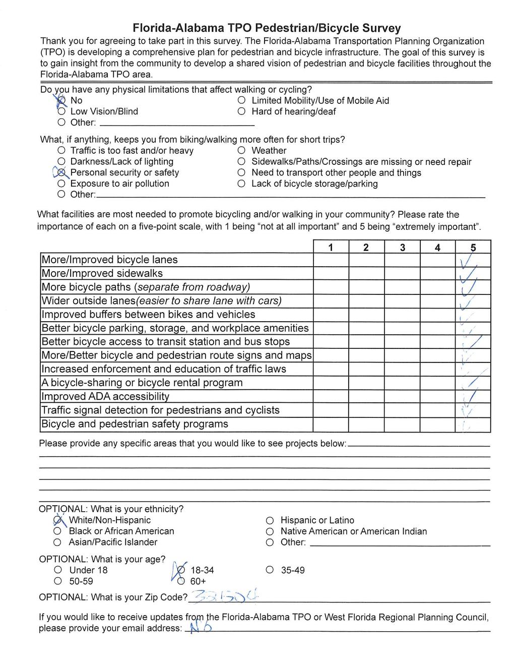
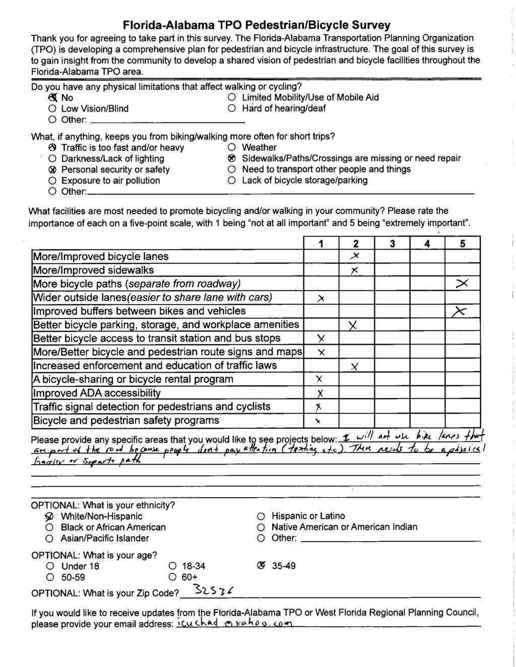
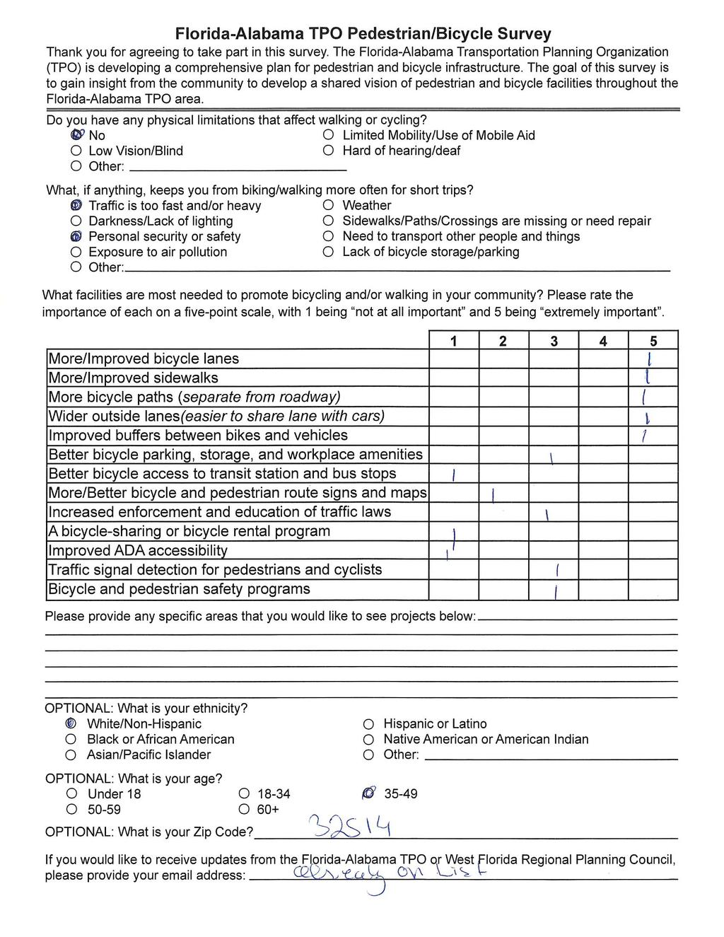
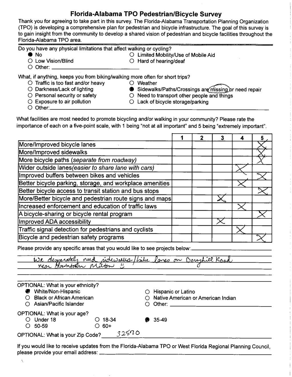
41
42
43
44
45

46

47
48 What, if anything, keeps you from bicycling/walking more often for short trips? Traffic is too fast and/or Weather Darkness/Lack of Lighting Concerned about personal security or safety Need to transport other people and things Exposure to Air Pollution Other Total What, if anything, keeps you from bicycling/walking more often for short trips? Other Exposure to Air Pollution Need to transport other people and things Concerned about personal security or safety Darkness/Lack of Lighting Weather
49 What facilities are most needed to promote bicycling and/or walking in your community? t at all Important Un Neutral Important Important Total More/improved bicycle lanes More/improved sidewalks More bicycle paths (separate from roadway) Wider outside lanes (easier to share lane with cars) Improved buffers between bikes and vehicles Better bicycle parking, storage and workplace amenities Better bicycle access to transit station and bus stops More/better bicycle and pedestrian route signs and maps Increased enforcement and education of traffic laws A bicycle sharing or bicycle rental program Improved ADA accessibility Traffic signal detection for pedestrians and cyclists Bicycle and pedestrian safety programs What facilities are most needed to promote bicycling and/or walking in your community? More/improved bicycle lanes More/improved sidewalks More bicycle paths (separate from roadway) Wider outside lanes (easier to share lane with cars) Improved buffers between bikes and vehicles Better bicycle parking, storage and workplace amenities Better bicycle access to transit station and bus stops More/better Increased bicycle and enforcement pedestrian routeand education of signs and maps traffic laws A bicycle sharing or bicycle rental program Improved ADA accessibility Traffic signal Bicycle and detection for pedestrian pedestrians and safety programs cyclists t at all Important Un Neutral Important Important
50 What, if anything, keeps you from bicycling/walking more often for short trips? What, if anything, keeps you from bicycling/walking more often for short trips? What, if anything, keeps you from bicycling/walking more often for short trips? Weather What, if anything, keeps you from bicycling/walking more often for short trips? What, if anything, keeps you from What, if anything, keeps you from bicycling/walking more often for short bicycling/walking more often for trips? short trips? Concerned about personal security or safety What, if anything, keeps you from bicycling/walking more What, if anything, keeps you from bicycling/walking more often for short trips? N/A Concerned about personal security or Darkness/Lack of lighting safety N/A Concerned about personal security or Weather Darkness/Lack of lighting safety Exposure to air pollution N/a Weather Darkness/Lack of lighting N/A Weather Darkness/Lack of lighting N/A Darkness/Lack of lighting N/A Other If you selected "Other" in the previous question, please specify. If you did not select other, please put N/A. N/A na Lack of infrastructure to support bike commuting Darkness/Lack of lighting N/A Darkness/Lack of lighting Concerned about personal security or safety N/A Need to transport other people and things n/a Darkness/Lack of lighting Concerned about personal security or safety NA N/A Concerned about personal security or safety N/A N/A Darkness/Lack of lighting N/A Other Proximity of services N/a N/A Darkness/Lack of lighting NA Concerned about personal security or safety Need to transport other people and things NA Concerned about personal security or safety Other t applicable Bike paths Concerned about personal security or safety Other N/A N/A N/A n/a N/A NA
51 Other sidewalks or trails to walk on Darkness/Lack of lighting N/A Darkness/Lack of lighting Concerned about personal security or safety N/a Concerned about personal security or safety Exposure to air pollution N/a Concerned about personal security or safety Concerned about personal security or safety Concerned about personal security or safety Concerned about personal security or safety Concerned about personal security or safety Weather Darkness/Lack of lighting n/a N/A Weather Darkness/Lack of lighting N/A Darkness/Lack of lighting N/A. Darkness/Lack of lighting Darkness/Lack of lighting Concerned about personal security or safety Concerned about personal security or safety Concerned about personal security or safety Concerned about personal security or safety Concerned about personal security or safety Other Other N/A n/a Na Driving public often seems ingnorant/uncaring of cyclist rights, needs, experiences, and techniques for "surviving" on sharerd roads. n/a N/A Na N/A Need dedicated bike/walking trails. Roads are too dangerous Na N/A Traffic Na n/a Other N/A N/A N/A N/A N/A n/a
52 Do you have any physical limitations that affect walking or bicycling? More/Improved bicycle lanes Important More/Improved sidewalks More bicycle paths (separate from roadway) Wider outside lanes (easier to share lane with cars) Improved buffers between bikes and vehicles Better bicycle parking, storage, and workplace amenities Better bicycle access to transit station and bus stops More/Better bicycle and pedestrian route signs and maps Increased enforcement and education of traffic laws A bicycle-sharing or bicycle rental programs Improved ADA accessibility Traffic signal detection for pedestrians and bicyclist Important Important Important Important Nuetral Important Nuetral Un Important Un Un Nuetral Un Un Nuetral Nuetral t at all Nuetral Un Un Important Un Nuetral Important Important Important Nuetral Important Important Nuetral Important Un Nuetral Important t at all Un Nuetral Important Nuetral Nuetral Important Nuetral Important Nuetral Important Important Important Important Nuetral Important Nuetral Nuetral Important Important t at all Nuetral Nuetral Important Un t at all t at all Nuetral t at all Nuetral Important Nuetral Important Important Important Nuetral Important Un Un Nuetral Un Nuetral Un Important Important Important Important Important Important Important Important Important Important Important Important Important Important Important Important Important Important Important Important Important Important Important Important Un Important Un Nuetral Important Important Important Nuetral Important Important Important Nuetral Nuetral Nuetral Important Important Nuetral Important Important Important Important Important Important Un Nuetral Nuetral Important Nuetral Important Nuetral Important Important Important Un Un Important Important Important Nuetral Nuetral Nuetral Important Important Important Important Nuetral Nuetral Important Important Important Important Nuetral Important Important Nuetral Nuetral Important Nuetral Important Important Important Important Important Important Important Important Nuetral Nuetral Important t at all Nuetral Nuetral Important Important Important Important Important Important Important Important Important Important Un Nuetral Nuetral Nuetral Nuetral Important Nuetral Nuetral Important Important Important Important Nuetral Nuetral Nuetral Important Bicycle and pedestrian safety programs Nuetral Nuetral Nuetral Nuetral Nuetral Important
53 t at all Important Nuetral Important Important t at all t at all Un t at all t at all Nuetral Important Important Important Nuetral Important Nuetral Nuetral Important Important Un Important Important Nuetral Limited mobility/use of mobile aid Important Important t at all Important Nuetral Nuetral Important Important Nuetral Important Nuetral Important Important Nuetral Important Un Nuetral Nuetral Nuetral Important t at all Nuetral Important Important t at all Nuetral Nuetral Nuetral Nuetral t at all Nuetral Important Nuetral Nuetral Un Un Un Nuetral t at all t at all Important Important Important Important Important Important Important Important Important Un Nuetral Important Important Hard of hearing/deaf Important Nuetral Important Important Nuetral Important Important Important Important Nuetral Important Important Important Nuetral Important Important Nuetral Nuetral Nuetral Important Important Important Nuetral Important Nuetral Nuetral Important Nuetral Nuetral Important Important Nuetral Un Un Important Important Nuetral Nuetral Important Important Important Nuetral Important Nuetral Nuetral Important Important Nuetral Important Important Nuetral Important Un Nuetral Nuetral Nuetral Nuetral Important t at all t at all Important Important Important Important Nuetral Important Important Nuetral Nuetral Important Nuetral Important Nuetral Important Un Nuetral Nuetral Nuetral Important Nuetral Nuetral Nuetral Important Important Nuetral Nuetral Nuetral Important Nuetral Nuetral Nuetral Un Un Important Important Important Important Nuetral Important Nuetral Un Un Nuetral Important Nuetral Nuetral Nuetral Nuetral Musculo skeletal issues Limited mobility/use of mobile aid Walking is limited due to Type II Diabetes and loss of feeling in the feet and toes. Nuetral Nuetral Nuetral Important Important Nuetral Nuetral Nuetral Un Important Important Nuetral Un Un Un Un t at all t at all Nuetral t at all Nuetral Important Nuetral Important Nuetral Important
54 Nuetral Important Important Nuetral t at all Nuetral Nuetral t at all Nuetral Important Important Nuetral Important Nuetral Nuetral Nuetral Nuetral Important Nuetral Nuetral Nuetral Nuetral Nuetral Nuetral Nuetral Nuetral Important Important Nuetral Nuetral Important Important Nuetral Nuetral Important Important t at all t at all Important Important Important Important Nuetral Nuetral Nuetral Important Nuetral Important Important Important t at all Important Nuetral Nuetral Important Important Nuetral Important Important Important Important Important Important Important Un Nuetral Nuetral Important Un Nuetral Important Nuetral Important Important Nuetral Limited mobility/use of mobile aid Important Important Important t at all Nuetral Important t at all Nuetral Nuetral Nuetral Nuetral Nuetral Nuetral Un t at all t at all t at all t at all t at all t at all t at all t at all Nuetral Nuetral Nuetral Nuetral Nuetral Important Nuetral Nuetral Nuetral Nuetral Nuetral Important Nuetral Nuetral Important Important Important Important Important Important Important Important Nuetral Nuetral Important Nuetral Important Important Un Un Un Un Un t at all t at all t at all t at all t at all t at all t at all t at all t at all Important Un t at all t at all t at all Nuetral Nuetral Nuetral Important Important Nuetral Nuetral Important t at all t at all Important t at all t at all t at all t at all t at all t at all t at all t at all Nuetral Important Important Important Important Important Important Important Important Important Nuetral Un t at all Un t at all Nuetral Nuetral Nuetral Important Un Important t at all t at all Un Un t at all Un Un Un Nuetral Important Important Nuetral Important Important Un Nuetral Nuetral Important Important Important Important Important Nuetral Nuetral Important Important Nuetral Important Nuetral Important Important Important Nuetral Nuetral t at all Nuetral Nuetral Important Important Important Nuetral Important Important Un t at all Important Important
55 Important Important Un Important Important Important Important Important Important Nuetral Important Important Nuetral Nuetral Important Important Nuetral Nuetral Important Un Nuetral Important t at all Un Un Un Nuetral Nuetral Nuetral Important Important Un t at all Nuetral t at all t at all Nuetral t at all Un Important Important Important Nuetral Nuetral Important Un Un Un Un Nuetral Important Un Important Un t at all t at all Important t at all Nuetral Nuetral Un Un Nuetral Nuetral t at all Important Nuetral Important Important Nuetral Important Nuetral Nuetral Important Important Important Important Important Nuetral Important Important t at all Un Un t at all Un Un Important Un Nuetral Nuetral Nuetral Nuetral Important Nuetral Important Important Nuetral Nuetral t at all t at all t at all t at all t at all Nuetral Important Important Important Important Important Important Nuetral Important Un Un Un Un Un Nuetral Important t at all Important Important Important Important Important Important Important Important Nuetral Nuetral Un Important Nuetral Important Nuetral Nuetral Important Nuetral Nuetral Un Important Nuetral Important Important Nuetral Important Important Important t at all Nuetral Important
56 OPTIONAL: What is your age? Optional: What is your Zip Code? OPTIONAL: If you would like to receive updates from the Florida-Alabama TPO or West Florida Regional Planning Council, please provide your address: OPTIONAL: What is your ethnicity? White/n- Hispanic White/n- Hispanic 60+ White/n- Hispanic White/n- Hispanic Black or African American White/n- Hispanic 60+ White/n- Hispanic 60+ White/n- Hispanic bi-racial White/n- Hispanic White/n- Hispanic White/n- Hispanic White/n- Hispanic 60+ Black or African American White/n- Hispanic White/n- Hispanic White/n- Hispanic White/n- Hispanic White/n- Hispanic White/n- Hispanic Date Created :54: :59: :05: :06: :10: :14: :57: :21: :21: :42: :55: :39: :43: :24: :28: :57: :17: :47: :04: :08:45
57 White/n- Hispanic 60+ White/n- Hispanic White/n- Hispanic White/n- Hispanic 60+ Hispanic or Latino White/n- Hispanic White/n- Hispanic White/n- Hispanic N/A White/n- Hispanic White/n- Hispanic White/n- Hispanic White/n- Hispanic Black or African American White/n- Hispanic White/n- Hispanic White/n- Hispanic White/n- Hispanic White/n- Hispanic :39: :42: :17: :31: :23: :54: :39: :39: :38: :03: :36: :37: :45: :27: :33: :10: :16: :55: :09: :35:27
58 White/n- Hispanic White/n- Hispanic White/n- Hispanic White/n- Hispanic White/n- Hispanic White/n- Hispanic White/n- Hispanic Hispanic or Latino White/n- Hispanic White/n- Hispanic White/n- Hispanic White/n- Hispanic White/n- Hispanic Hispanic or Latino White/n- Hispanic White/n- Hispanic White/n- Hispanic White/n- Hispanic White/n- Hispanic :03: :19: :05: :22: :21: :42: :06: :03: :15: :52: :29: :51: :32: :22: :32: :35: :41: :07: :14: :17: :28:55
59 White/n- Hispanic White/n- Hispanic White/n- Hispanic Hispanic or Latino White/n- Hispanic White/n- Hispanic White/n- Hispanic White/n- Hispanic White/n- Hispanic White/n- Hispanic White/n- Hispanic :34: :45: :21: :12: :35: :09: :11: :56: :00: :17: :12: :28:13 Native American or American Indian White/n- Hispanic Other White/n- Hispanic White/n- Hispanic White/n- Hispanic White/n- Hispanic :50: :07: :51: :44: :46: :12: :55:35
60 White/n- Hispanic White/n- Hispanic White/n- Hispanic White/n- Hispanic White/n- Hispanic White/n- Hispanic 60+ White/n- Hispanic White/n- Hispanic White/n- Hispanic White/n- Hispanic White/n- Hispanic White/n- Hispanic White/n- Hispanic White/n- Hispanic White/n- Hispanic 60+ White/n- Hispanic White/n- Hispanic White/n- Hispanic :54: :11: :01: :27: :19: :10: :31: :27: :52: :19: :38: :32: :05: :42: :16: :23: :11: :25: :52: :08: :59:34
61 White/n- Hispanic :51:22
62 Please provide any specific areas that you would like to see projects below: I would like to see more interconnected multiuse paths throughout the W FL area that could be utilized for commuting and recreation Restriping roads with 12 ft lanes for narrower lanes and a bike path. Install traffic calming devices to ensure pedestrian and cyclist safety. More bike lanes. Repair of existing sidewalks. Less expensive roadway design that leads to sprawl, this includes widening projects. Widening roads does not improve congestion, every traffic engineer is aware of this. It also doesn't make economic sense, no ROI. Cantonment area where I live has no side walks or paths so it is almost impossible to ride my bike. I would love to see sidewalks (like in Tampa) where you see people walking, biking, pushing babies in strollers. Our town is missing out on so much. It's a shame. The downtown and East Pensacola areas. East Pensacola is working on it, but downtown and along Cervantes and Palafox could definitely use improvement. As the number of neighborhoods and residential units are increasing around Downtown, attention needs to be placed on alternative transportation. Bicycle lanes to Downtown from the rth Hill and East Hill areas need to be improved as well as more cross walk signs that can signal traffic to stop so that walkers and cyclists can cross busy streets (Cervantes for example). I know that there is no room to widen Palafox Street, but perhaps redirect traffic on weekend evenings to go around Palafox to allow cyclists safe riding. I am always nervous on weekend evenings riding Downtown as there is lots of traffic with people who are drinking and dinning Downtown. Maybe close Palafox from Garden to Main Street (similar to Gallery Nights) for bicycles and pedestrians. We need real bicycle racks Downtown that can hold more than two bicycles at a time. The cute bicycle racks are just that, cute, but impractical if Downtown wants more alternative transportation, we need to lock our bicycles up to something and a nice rack is better than a tree or light post. Finally, some PSA for drivers to recognize that bicycles have the right to be on the road as well. More trails and safe riding areas for families. Orange beach has wonderful trails at Gulf State Park (beautiful wooden bridges through the landscape/woods, and we do drive over, but that's an hour and a half drive! We need something like that here in our area...pensacola, Cantonment, Walnut Hill area. Thanks for any help in making this happen :)
63 I would like to see mandatory driver's education in all Florida high schools, with a dedicated day focusing on bicycle pedestrian rights and challenges. If a state-wide program is too ambitious right away, we should lead the way locally as a cost effective model for the rest of the state. Scenic Hwy area could use wider bike lanes and a more expansive sidewalk. 9th Ave is incredibly scary on a bike and for pedestrians Fairchild Ave could use a sidewalk for pedestrians. Lots of foot traffic since it's a cut through between Davis Hwy and Tippin. Muldoon Road from Sayfley Field Rd to Blue Angel Hwy, Cerney Road from Blue Angle Hwy to Marlane Road, and Marlane Rd to Mobile Hwy, also Patricia Ave from Cerney Road to Failfield Drive. I would like to see bike lanes and sidewalks installed. bike lanes for major thrufares. I think having a continuous buffered bike lane from Scenic Hwy through Cervantes (stopping around E st) would allow more people to make commuting to work and events possible. It would also be nice to have a continuous buffered bike lane on Palafox, Davis, and Bayou Blvd. City core - downtown, East Hill, rth Hill Make safe connections between neighborhoods in city of Pensacola--enhanced bike/ped crossings across busy State roads such as Cervantes, 9th Ave., Garden St., Gregory St./Hwy 98 downtown, so that riders and cyclists can get from East Hill and Eastside and rth Hill and into downtown Pensacola. Require buildings be built closer to the street with parking to the side or back--this narrows the driver's field of view and makes traffic slow down. Walkable and bikeable communities have to have slower traffic speeds. Yes Bicycle paths that connect. And paths that go some where.. I would like to see a "pedestrian/cyclist experience" unit required in mandatory Driver's Education classes for all high school students. I would think it a relatively inexpensive way to educate and promote understanding, possible even empathy as young new drivers take to the road. In addition, it would educate them on cyclist/pedestrian rules and responsibilities since all road users need to adhere to the law. A potentially large return for a relatively small investment.
64 Mobile Highway-West Pensacola, Beulah Road rthwest Pensacola, Munson Highway-Milton Fl I would like to see bikes lanes added along Munson Hwy extending from the bike path up to Springhill rd. The speed of cars through here is also too high. In cities that have wider outside lanes, the cars usually pull to the outside when at a light. This prevents bikes from moving forward. Travel thru Gulf Breeze, FL and you will understand that it would be better for dedicated bike paths. Scenic Highway, Cervantes, Hyde Park Road, Airport Blvd Navarre A sidewalk on Hamilton Bridge Road in Milton, extending from Glover Lane to Dogwood Drive would connect the planned sidewalk for Glover Lane to the existing sidewalk on Dogwood Drive. I think a sidewalk in this area was discussed at one time but I do not know if it made it into the plan. It is an approximate 1/2 mile stretch of road but because it would connect a planned project with an existing project, I think it would be relatively small project with a big impact. I would definitely ride my bike to work if that connection was made but as it is the street is too narrow in that section for vehicles to share it with a bike or pedestrian. Scenic Highway from the Apple Market all the way to Highway 90 in Pensacola. This area should have a separate bike/walking/running paved pathway separated from the traffic along the road. If this were built the area and people would use it continuously. Mobile Hwy and downtown Along the bays. Safer bike lines to/from Gulf Breeze and Pensacola. If there was any way to separate a bike/walking lane from 98...that would be spectacular... I have to day Santa Rosa is doing a very good job on 87 through Navarre Chumuckla Hwy Berryhill Rd (near Chumuckla hwy) Woodbine Rd Pedestrian bridges are needed to safely cross highway 90 and to provide safe access from Floridatown to SS Dixon primary and Pace High School. Side walks in that area are a must. Scenic highway, Summit, Cervantes ~Brownsdale Community between Chumuckla & Jay~ More bike paths and sidewalks. Lillian highway, Dog Track road, Bauer road, Sorento road. Willard rris hwy from pine blossom road to dogwood drive.
65 Frequent flats are VERY common especially over bridges. They should be swept more often to pick up glass. The best option for recreational cyclists is to have a paved trail off the roads. The stretches that exist today don't have a good way to connect. Using busy roads is NOT a good solution. Hwy 98 is extremely dangerous even with improved bike lines. Very difficult to cross. A long wait for a signal. Gulf Breeze has no bike lane even though it indicates a bike-sharing lane. Parks should be more biker friendly. Do we really need to stop and pay if passing in/out? Also, gates, chains, loose gravel, closed restrooms are not biker friendly. Hwy87N Milton Florida. It's is a busy highway where bicyclists love to ride. It would be nice to have a safety measure put into place to bring more in and know that that safety is first. Lots of wrecks on this highway and fast traffic. Bike lanes in and around Pensacola need to be connected. There are too many fragmented sections that don't allow good navigation to and from places using the existing bike lanes. Need a public map of all bike lanes and even go as far as labeling them with specific route colors and names, similar to a bus line or metro map. I should be able to ride a bicycle from Cordova Mall to Downtown on protective bike lanes, right now I don't think that is possible. Enforce laws to aimed at texting and driving. Create more bike paths that are separate from traffic such as along rail lines or creeks and rivers. I would like to see a dedicated bike lane on Munson hwy. At the very least from the bike trail extending to Springhill rd. I would also like to see more protected/separated bike paths where space allows throughout the area. Perdido Key and gulf beach highway are part of the national bike route system, but they lack sufficient bike lanes for safe travel or sidewalks for pedestrians. The lanes on Alabama side of key are much better wider with some separation from traffic. The bridge to Perdido key on Fl side is dangerous for walkers and bikers - - a separate bike/walkway could be retrofitted to the bridge as been done with other existing structures. There are many people in area who bike and walk out of necessity and some of us who bike and walk for fun and exercise. Any new paving should consider bikers and pedestrians. Incorporation of bike lanes into all roads being repaved should be standard, given sufficient width in roadbed. I would like to see a protected multi-use path along W Spencer Field Rd in Pace from Berryhill Rd to Hwy 90. This would serve several neighborhoods, 4 public schools, and a grocery store along a 3 mile heavily travelled road. More bike lanes Restriping rth 9th Avenue between Keating Road and Beau Terra Lane to include bike lanes on both sides to promote safe travel over I-10. This is only one of 2 areas to cross I-10 in East Pensacola, and is dangerous. The existing center lane is feet wide and perhaps can be reduced to accommodate outside bike lanes without altering road/bridge width. Though either a reduced posted speed limit or a barrier wall may be needed to meet design criteria. I would like to see more education of the drivers in our community. I often get bullied and threatened for riding my bike on the side of the road. I have even had very close calls with police cars not paying attention to my space as a bicyclist. Police officers do not seem to know or perhaps they do not care enough about the safety and rights of bicyclists. I have had the occasion where a truck was being aggressive with me, passed me and cut me off in front of a police officer who did nothing.
66 1) Approved bicycle/pedestrian routes which create a grid throughout the City (and County) with bike lanes and sharrows. It could begin in downtown Pensacola and broaden out to create a loop surrounding the City with inter-cutting routes so that we'd have designated bike routes running north/south, east/west in a larger encircled zone which could then connect to Alabama and more eastern Florida. Appropriate signing and road painting should accompany the plan with public service announcements educating the public on bike/ped issues. 2) turn the entirety of 12th Avenue in Pensacola into a bike/ped pathway, connecting it to the bike lanes at the bridge and again at the Bayou Blvd. intersection, extending via Summit to Scenic. A barrier on the bike lanes would make me interested in actually using them. Also more rails to trails or bike trails under all of pensacola's power line easments. (Pensacola)


67 Wolfe Creek Forest Gap General Location Military Heritage Trail Extension EVERS RD OGLESBY RD SONNY DOZIER RD SPRINGHILL RD ALLENTOWN RD HWY 87 N Wolfe Creek Proposed Wolfe Creek Trail JESSE ALLEN RD HIGHWAY 87 N REDBIRD TR HUTCHINS RD FFS W45 REMINGTON RD WHITING FIELD CIR SARATOGA ST RANGER ST INTREPID RD Proposed Military HeritageTrail Connection MUNSON HWY PEADEN HILL RD HWY 89 SANDY HILL LN FALL ST FLEET AV BRUCE LN WILMAR AV LANGLEY ST TRAIL RIDE NORTH TRAIL RIDE SOUTH SOUTH PERIMETER RD NAS Whiting Field MARTY MARTIN WAY EAST GATE RD MUNSON HWY Blackwater Heritage State Trail CABIN LN INDIAN FORD RD FFS TR BAXLEY RD LUND RD PARKER RD <all other values> STATUS EXISTING GAP NO ACQUISITION GAP REQUIRING ACQUISITION PROGRAMMED/FUNDED Whiting Military Trail Streets State Lands Military Airport Zones 1 in = 1 miles µ Miles
68
69
70
71
72
73
74 To: From: David Wood Martha T. Hicks and Jerry Faller Sub: Supplements to the Application 2018 Florida TPO Pedestrian Bicycle Master Plan Project Submitted Form Item #2 Supplement of the application The Avalon Beach subdivision streets selected for sidewalk are: 1. Del Monte Rt and Lt of Avalon Boulevard 2. San Monica Rt and Lt of Avalon Boulevard 3. Mulat Road 4. Monticetto (rth and South of 14 th Avenue) 5. San Miguel 6. 1 st Street all the way to 38 th Avenue (Rt and Lt of Avalon Boulavard 7. Santa Cruz 8. Glade Drive 9. Cyanamide (Sterling) 10. San Blas 11. San Juan 12. Atlas 13. Electra 14. Ruth Ct 15. Pamona Street 16. Summer Drive Item #3 Supplement to the application: $1.300 per square foot for building a five foot wide by 6 inches high sidewalk. The estimated cost will be 1 Million and a Half considering sidewalk site preparation and 4 retention ponds in the area. Copy of the application and this supplement was faxed to Shawn Ward, Director of Santa Rosa County Planning. If you have any questions please feel free to contact me at or Mr. Faller, President of the Avalon Beach Property Owners Association at Very Respectfully, Martha T. Hicks
DRAFT FY 2017-FY 2021 FLORIDA-ALABAMA NON-SIS PROJECT PRIORITIES PROPOSED CHANGES BY ESCAMBIA AND SANTA ROSA COUNTIES
 DRAFT FY 2017-FY 2021 FLORIDA-ALABAMA NON-SIS PROJECT PRIORITIES PROPOSED CHANGES BY ESCAMBIA AND SANTA ROSA COUNTIES Table 2: Non-Strategic Intermodal System (Non-SIS) Project Priorities FDOT Item- Phases
Duwamish Way-finding and CTR Report
 V. North Tukwila When the North Tukwila Manufacturing and Industrial Center was designated in 1992 as part of the region s land use and transportation plan, the plan called for the area to set a light-rail
12/4/2016 VIA . RE: Grocery Outlet Del Paso (DR16-328)
") 12/4/2016 VIA EMAIL Ethan Meltzer, Assistant Planner City of Sacramento Community Development Department 300 Richards Blvd, 3 rd Floor Sacramento, CA 95811 RE: Grocery Outlet Del Paso (DR16-328) Dear Mr.
12/4/2016 VIA EMAIL Ethan Meltzer, Assistant Planner City of Sacramento Community Development Department 300 Richards Blvd, 3 rd Floor Sacramento, CA 95811 RE: Grocery Outlet Del Paso (DR16-328) Dear Mr.
Lee s Summit Road Improvement Study Public Open House June 7, 2007 Summary of Comment Card Responses
 Lee s Summit Road Improvement Study Public Open House June 7, 2007 Summary of Comment Card Responses Introduction At the Lee s Summit Road Improvement Study Public Open House held Thursday, June 7, 2007
Winnipeg Walk Bike Projects Downtown Tire Talk - Summary
 Winnipeg Walk Bike Projects Downtown Tire Talk - Summary Downtown Projected Bike Lane System Connecting The Forks to the Exchange District (Fort Street, Garry Street & The Forks to Assiniboine Connection)
2018 Florida-Alabama TPO Pedestrian Bicycle Master Plan Existing Policies and Plans
 Introduction 2018 Florida-Alabama TPO Pedestrian Bicycle Master Plan Existing Policies and Plans A main focus of this plan is the identification and prioritization of pedestrian and bicycle facility projects.
Chapter 5. Complete Streets and Walkable Communities.
 Chapter 5. Complete Streets and Walkable Communities. 5.1 Description of Complete Streets. Cities throughout the world, and specifically the United States, are coming to embrace a new transportation and
Summary of Comments Public Meeting: Marietta Street Resurfacing Project Atlanta Contemporary August 29, 2017 / 6:00 pm to 8:00 pm
 Renew Atlanta hosted a public meeting to discuss the Marietta Street Resurfacing project at. Councilmember Cleta Winslow attended the public meeting, where over seventy (70) citizens to include representatives
Non-Motorized Transportation 7-1
 Non-Motorized Transportation 7-1 Transportation facilities no longer mean just accommodating a vehicle powered by a combustion engine. Pedestrian and non-motorized facilities are important modes of travel
5 CIRCULATION AND STREET DESIGN
 5 CIRCULATION AND STREET DESIGN This chapter describes circulation and streetscape improvements proposed for the Northwest Chico Specific Plan Area. It includes detailed design specifications for existing
MASTER BICYCLE AND PEDESTRIAN PLAN
 VILLAGE OF NORTHBROOK MASTER BICYCLE AND PEDESTRIAN PLAN DRAFT PLAN OPEN HOUSE May 2, 2018 AGENDA 1. Community Engagement 2. Vision and Goals 3. General Structure of Plan 4. Recommendations Overview 5.
Chapter 3 DESIGN SPECIFICATIONS
 Brampton PathWays Planning and Design Guidelines 27 Chapter 3 DESIGN SPECIFICATIONS 3.1 CLASS 1 MULTI-USE PATH Off-road multi-use trails are the backbone of the Brampton PathWays Network. They are typically
Monroe Street Reconstruction
 Total participants: 45+ Monroe Street Reconstruction Cross Section Workshop Notes September 29, 2016, Wingra School Workshop Orientation, Technical and Functional Considerations: The workshop began with
What are the Qualities that make Newark a Bicycle Friendly Community? What are aspects that make Newark less Bicycle Friendly?
 What are the Qualities that make Newark a Bicycle Friendly Community? Many stores are within biking distance (1) Lots of bike lanes and new trail Existing bike routes (2) Designated bike lanes on Del ave.
PEDESTRIAN ACTION PLAN
 ATTACHMENT 2 CITY OF SANTA MONICA PEDESTRIAN ACTION PLAN CITY OF SANTA MONICA PEDESTRIAN ACTION PLAN This page intentionally left blank EXECUTIVE SUMMARY CHAPTER 1 EXECUTIVE SUMMARY Setting the Stage
City of Charlottesville Bicycle and Pedestrian Master Plan Update
 City of Charlottesville Bicycle and Pedestrian Master Plan Update September 17, 2014 I. Welcome and meeting overview II. Project status update III. Network overview IV. Break-out groups Pedestrian Network
10/30/2012 VIA
 10/30/2012 VIA EMAIL David Hung, Associate Planner Community Development Department, Current Planning Division City of Sacramento 300 Richards Blvd., 3 rd Floor Sacramento, CA 95811 RE: The Cannery On-Site
Cyclists and Bikeways: What s your match? A guide to bikeway options for a variety of cyclists
 Cyclists and Bikeways: What s your match? guide to bikeway options for a variety of cyclists The workshop and this resource were made possible by funding from the Province of Ontario via the Ministry of
Florida DOT Case Study
 Florida DOT Case Study 1 Background In 2013, MetroPlan Orlando became one of the first planning agencies in the world to use Strava Metro data to make better decisions about where to improve bicycle and
Perryville TOD and Greenway Plan
 Perryville TOD and Greenway Plan Greenway Glossary Pathway: A bicycle and pedestrian path separated from motorized vehicular traffic by an open space, barrier or curb. Multi-use paths may be within the
3/10/2016 VIA th Street, Suite 203 Sacramento, CA
 3/10/2016 VIA EMAIL Arwen Wacht, Associate Planner City of Sacramento Community Development Department 300 Richards Boulevard, 3 rd Floor Sacramento, CA 95811 RE: Natomas Fountains (P16-012) Dear Ms. Wacht:
Bikeability Checklist
 Bikeability Checklist How bikeable is your community? Riding a bike is fun! Bicycling is a great way to get around and to get your daily dose of physical activity. It's good for the environment, and it
8/1/2018 VIA . Darcy Goulart City of Rancho Cordova Planning Department 2729 Prospect Park Drive Rancho Cordova, CA 95670
 8/1/2018 VIA EMAIL Darcy Goulart City of Rancho Cordova Planning Department 2729 Prospect Park Drive Rancho Cordova, CA 95670 RE: Towne Place Suites by Marriott Hotel (DD9806) Dear Ms. Goulart: WALKSacramento
Transportation 2040 Update: Eudora Public Input As of June 1, 2017
 Transportation 2040 Update: Eudora Public Input As of June 1, 2017 Overview... 1 Survey Responses... 2 Overview The Lawrence Douglas County Metropolitan Planning Organization (MPO) is updating our long
Orinda Bicycle, Trails and Walkways Master Plan
 Orinda Bicycle, Trails and Walkways Master Plan Public Meeting October 15, 2008 Presented by: Ian Moore, Alta Lauren Ledbetter, Alta Bruce Wolff, Alta Introductions City of Orinda Monica Pacheco, Assistant
COWETA HIGH SCHOOL AND EAST HIGHWAY 51
 COWETA HIGH SCHOOL AND EAST HIGHWAY 51 Lack of sidewalks along Ben Lumpkin Rd. Lack of crosswalks and ramps at intersection. Hwy 51 is wide to cross as a pedestrian. No ADA compliance or connection to
Needs Plan Report FLORIDA-ALABAMA 2040 LONG RANGE TRANSPORTATION PLAN
 Needs Plan Report FLORIDA-ALABAMA 2040 LONG RANGE TRANSPORTATION PLAN Prepared for Florida-Alabama Transportation Planning Organization and The Florida Department of Transportation, District Three Prepared
Appendix C 3. Bicycle / Pedestrian Planning
 Appendix C 3. Bicycle / Pedestrian Planning BICYCLE/PEDESTRIAN PLANNING 2005 Master Plan GOAL: Provide for safe and convenient bicycle and pedestrian circulation throughout the City. Develop a city-wide
This page intentionally left blank.
 This page intentionally left blank. COMMUNITY Coweta Community Overview Coweta Coweta, a residential community located in Wagoner County, is a suburb of Tulsa situated southeast of the metropolitan area
Vallecito Elementary School. Travel Plan
 Vallecito Elementary School Travel Plan TABLE OF CONTENTS 1. PURPOSE... 1 1.1. SR2S PLANNING, IMPLEMENTATION AND MONITORING... 1 1.2. MARIN COUNTY MEASURE A... 1 2. VALLECITO ELEMENTARY SCHOOL PROFILE...
Public Feedback Comments Appendix G. Appendix G. Public Feedback Comments. Virginia Beach Bikeways and Trails Plan 2011 Page G-1
 Public Feedback Comments Virginia Beach Bikeways and Trails Plan 2011 Page G-1 This is a complete collection to date of responses to the feedback survey which was used at public open houses in December
TOWN OF WILLIAMSTON, SC BICYCLE AND PEDESTRIAN MASTER PLAN TOWN OF WILLIAMSTON, SC BICYCLE AND PEDESTRIAN MASTER PLAN
 TOWN OF WILLIAMSTON, SC BICYCLE AND PEDESTRIAN MASTER PLAN Americans Want Choices 55% of Americans would rather drive less & walk more. Transit use is growing faster than population or highway travel.
TRANSPORTATION TRAINING TOPICS. April 6, 2010
 TRANSPORTATION TRAINING TOPICS April 6, 2010 Roles of Transportation Providers Context and Policy Makers Division of Transportation and Traffic Other City Operations Other Transportation Operators CMA
5/7/2013 VIA . RE: University Village Safeway Expansion (P13-019)
") 5/7/2013 VIA EMAIL David Hung, Associate Planner Community Development Department, Current Planning Division City of Sacramento 300 Richards Boulevard, 3 rd Floor Sacramento, CA 95811 RE: University Village
5/7/2013 VIA EMAIL David Hung, Associate Planner Community Development Department, Current Planning Division City of Sacramento 300 Richards Boulevard, 3 rd Floor Sacramento, CA 95811 RE: University Village
2.0 Existing Conditions
 20 2.0 Existing Conditions 2.1 Land Use, Future Growth Patterns, Physical Barriers Geographic Overview Sutter County s land use pattern is characterized by extensive agricultural areas, significant natural
Living Streets Policy
 Living Streets Policy Introduction Living streets balance the needs of motorists, bicyclists, pedestrians and transit riders in ways that promote safety and convenience, enhance community identity, create
Prince George s County plans, policies, and projects
 Prince George s County plans, policies, and projects Over 250 projects for trails, bikeways, designated bike lanes and sidewalk construction Trail projects that improve access to Metro Sidewalk and trail
2014/2015 BIKE ROUTE PLAN 83 AVENUE PROTECTED BIKE LANE
 About the Project 2014/2015 BIKE ROUTE PLAN The City of Edmonton is planning a major bike route on the south side of Edmonton. This bike route is one part of a plan to provide citizens with transportation
Bay to Bay Boulevard Complete Streets Project
 Bay to Bay Boulevard Complete Streets Project Dale Mabry Highway to Bayshore Boulevard February 08, 2018 Photo Source: Tampa Bay Times Alessandra Da Pra Meeting Format Introduction Resurfacing Information
CITY OF PENSACOLA BICYCLE FRIENDLY COMMITTEE MEETING AGENDA
 CITY OF PENSACOLA BICYCLE FRIENDLY COMMITTEE MEETING AGENDA City Hall Vince Whibbs Conference Room 222 West Main Street, 1 st Floor Pensacola, FL 32502 August 11, 2017 8:30 a.m. 1. Call to order 2. Approval
7/23/2017 VIA . Michael Hanebutt City of Sacramento Community Development Department 300 Richards Boulevard, 3 rd Floor Sacramento, CA 95811
 7/23/2017 VIA EMAIL Michael Hanebutt City of Sacramento Community Development Department 300 Richards Boulevard, 3 rd Floor Sacramento, CA 95811 RE: 65 th Street Apartments (DR17-220) Dear Mr. Hanebutt:
Safe Streets. City of Lake Forest Park. March 21, 2017
 Safe Streets City of Lake Forest Park March 21, 2017 1 01 WELCOME 2 Agenda WELCOME WHAT IS THIS PROJECT? CONTEXT DRAFT CITYWIDE PROJECTS EXERCISE INTRODUCTION 3 02 WHAT IS THIS PROJECT? 4 WHAT IS THIS
Chapter 5 Future Transportation
 Chapter 5 Future Transportation The Future Land Use Plan identifies the desired land use designations. The land uses desired for Crozet depend, in large part, on the success of the transportation system,
2. TRANSPORTATION ELEMENT.
 2. TRANSPORTATION ELEMENT. The purpose of this element is to assist in establishing an adequate transportation system within the City and to plan for future motorized and non-motorized traffic circulation
TRANSPORTATION COMMISSION Agenda Staff Report
 TRANSPORTATION COMMISSION Agenda Staff Report Agenda Item No. 5.a DATE: JULY 31, 2014 TO: FROM: SUBJECT: TRANSPORTATION COMMISSION COMMUNITY DEVELOPMENT DEPARTMENT - PLANNING DRAFT OLYMPIC CORRIDOR PREFERRED
City of Novi Non-Motorized Master Plan 2011 Executive Summary
 City of Novi Non-Motorized Master Plan 2011 Executive Summary Prepared by: February 28, 2011 Why Plan? Encouraging healthy, active lifestyles through pathway and sidewalk connectivity has been a focus
9/21/2016 VIA . RE: The Knot (DR16-270)
") 9/21/2016 VIA EMAIL Garrett Norman, Assistant Planner City of Sacramento Community Development Department 300 Richards Boulevard, 3 rd Floor Sacramento, CA 95811 RE: The Knot (DR16-270) Dear Mr. Norman:
9/21/2016 VIA EMAIL Garrett Norman, Assistant Planner City of Sacramento Community Development Department 300 Richards Boulevard, 3 rd Floor Sacramento, CA 95811 RE: The Knot (DR16-270) Dear Mr. Norman:
8/31/2016 VIA . RE: Freeport Arco Fuel Station (P16-039)
") 8/31/2016 VIA EMAIL Garrett Norman, Assistant Planner City of Sacramento Community Development Department 300 Richards Boulevard, 3 rd Floor Sacramento, CA 95811 RE: Freeport Arco Fuel Station (P16-039)
8/31/2016 VIA EMAIL Garrett Norman, Assistant Planner City of Sacramento Community Development Department 300 Richards Boulevard, 3 rd Floor Sacramento, CA 95811 RE: Freeport Arco Fuel Station (P16-039)
What Is a Complete Street?
 Session 5 Charleen Zimmer, AICP, Zan Associates May 5-7, 2010 What Is a Complete Street? May 2010 5-1 Not a Complete Street More of a Complete Street May 2010 5-2 Benefits of Complete Streets Safety for
Fairview and Main Local Streets Improvement Plan
 PIM#2 Summary Report Meeting Format Date & Time: Location: Address: Prepared By: Community Open House August 11, 2016 5:30 p.m. 7:30 p.m. Red Lion Hotel 1800 W. Fairview Avenue, Boise Stephanie Borders,
Bikeway action plan. Bicycle Friendly Community Workshop March 5, 2007 Rochester, MN
 Bikeway action plan Summary The was held on March 5, 2007 at the Rochester Mayo Civic Center. The workshop was hosted by Rochester-Olmsted County Planning Department in collaboration with the League of
6/22/2018 VIA . Darcy Goulart, Planning Manager City of Rancho Cordova Planning Department 2729 Prospect Park Drive Rancho Cordova, CA 95670
 6/22/2018 VIA EMAIL Darcy Goulart, Planning Manager City of Rancho Cordova Planning Department 2729 Prospect Park Drive Rancho Cordova, CA 95670 RE: Quick Quack Car Wash (DD9801) Dear Ms. Goulart: WALKSacramento
West Dimond Blvd Upgrade Jodhpur Street to Sand Lake Road
 West Dimond Blvd Jodhpur St to Sand Lake CSS Transportation Project Summary Municipality of Anchorage Project # 05 005 Project Manager: John Smith, P.E. (MOA PM&E) Project Administrator: Julie Makela,
PEDALING FORWARD. A Glance at the SFMTA s Bike Program for SFMTA.COM
 PEDALING FORWARD A Glance at the SFMTA s Bike Program for 2017-2021 SFMTA.COM INTRODUCTION About This Booklet More people from all walks of life see their bicycle as a more convenient way to get where
GOAL 2A: ESTABLISH AND MAINTAIN A SAFE, CONVENIENT, AND EFFICIENT MULTI-MODAL TRANSPORTATION SYSTEM TO MOVE PEOPLE AND GOODS THROUGHOUT THE CITY.
 2. TRANSPORTATION ELEMENT The purpose of this element is to assist in establishing an adequate transportation system within the City and to plan for future motorized and non-motorized traffic circulation
CONNECTING PEOPLE TO PLACES
 CONNECTING PEOPLE TO PLACES 82 EAST BENCH MASTER PLAN 07 Introduction The East Bench transportation system is a collection of slow moving, treelined residential streets and major arteries that are the
2018 Transportation Alternatives Program (TAP) Application Presentation to Palm Beach TPA BRANT BRIDGE CONNECTION LOOP EXTENSION ON CARL BOLTER DR
 Application Presentation to Palm Beach TPA BRANT BRIDGE CONNECTION LOOP EXTENSION ON CARL BOLTER DR") 2018 Transportation Alternatives Program (TAP) Application Presentation to Palm Beach TPA BRANT BRIDGE CONNECTION LOOP EXTENSION ON CARL BOLTER DR Project Location N N Connecting South Delray Beach Existing
2018 Transportation Alternatives Program (TAP) Application Presentation to Palm Beach TPA BRANT BRIDGE CONNECTION LOOP EXTENSION ON CARL BOLTER DR Project Location N N Connecting South Delray Beach Existing
THE OFFICIAL GUIDE TO CYCLING SAFELY IN PHILADELPHIA
 B IKE NICE THE OFFICIAL GUIDE TO CYCLING SAFELY IN PHILADELPHIA A partnership of the City of Philadelphia and the Bicycle Coalition of Greater Philadelphia ABOUT VISION ZERO & BIKE NICE It s a great day
Thank you for attending
 Improving mobility safety comfort WELCOME Thank you for attending The purpose of this meeting is to: Learn about the project Prioritize potential walking and biking improvements on Snelling Ave Gather
Bobbie Walthall. Hi Bobby, please include these comments in tonight s CC packet. Thanks for your consideration, Phil Collison Lawrence Resident
 Bobbie Walthall From: Sent: To: Subject: Phil Collison Tuesday, October 16, 2018 9:44 AM Bobbie Walthall Comments for Agenda item 3 Bike Boulevard Hi Bobby, please include these comments
Creating walkable, bikeable and transit-supportive communities in Halton
 Creating walkable, bikeable and transit-supportive communities in Halton By presenting current research and best practices, the information in this paper is meant to support and broaden discussion on how
LANCASTER CITY BICYCLE NETWORK
 LANCASTER CITY BICYCLE NETWORK Downtown Merchants Meeting Wednesday, July 19, 2017 http://www.lancasteratp. DOWNTOWN WALKABILITY ANALYSIS What changes can be made, in the least amount of time, and for
SUMMARY OF TRANSPORTATION INVESTMENTS
 Santa Cruz County 2016 Measure D: Transportation Improvement Expenditure Plan - Approved by over 2/3 of Santa Cruz County voters on November 8, 2016 - Overview Measure D, the 2016 Transportation Improvement
Improvements Infrastructure Gap Assessment and Improvements Street Striping
 Infrastructure Project Proposal The federal-aid Safe Routes to School program funds infrastructure/engineering projects that fall into two categories: Design (available only to School Development Authority
Use this guide to learn more about walkability and how you can make your community safer to walk
 Walkability Guide Do You Enjoy Walking In Your Community? Use this guide to learn more about walkability and how you can make your community safer to walk 2 About This Guide Circulate San Diego believes
City of Davis East Covell Corridor Plan
 Community Open House #2 January 22, 2014 6:00 8:00 p.m. Veterans Memorial Center, Club Room City of Davis Introduction The (ECCP) is a taking a comprehensive look at the existing transportation systems
CHAPTER 3: Vision Statement and Goals
 Davidson Walks & Rolls: Active Transportation Master Plan CHAPTER 3 Contents: Overview Vision Statement Measurable Goals Public Outreach CHAPTER 3: Vision Statement and Goals Overview The vision statement
Austin Avenue Bridges Project. Public Meeting Summary
 Austin Avenue Bridges Project Public Meeting Summary June 29, 2016 Red Table Safety and Connectivity Notes: 1. Would like to see forensic report evaluations 2. What is the lifespan? 3. Extend safety considerations
Cascade Bicycle Club Recommendations
 Cascade Bicycle Club Recommendations The following recommendations are focused on improving bicycle commuting in the Duwamish (South Park, South Downtown, Georgetown and North Tukwila). The recommendations
TOWN OF PORTLAND, CONNECTICUT COMPLETE STREETS POLICY
 TOWN OF PORTLAND, CONNECTICUT COMPLETE STREETS POLICY I. VISION, GOALS & PRINCIPLES VISION To improve the streets of Portland making them safer and more accessible for all users including pedestrians,
Roads and Vehicular Traffic Design Principles. Roads and Vehicular Traffic Recommendations
 CIRCULATION AND PARKING roads and vehicular traffic The Campus Master Plan updates the campus transportation network through a multi-modal approach that encourages walking and biking while improving vehicular
Vision: Traditional hamlet with an attractive business/pedestrian friendly main street connected to adjacent walkable neighborhoods
 N D. Focus Area II Vision: Traditional hamlet with an attractive business/pedestrian friendly main street connected to adjacent walkable neighborhoods Transit Road Focus Area II is located in the Hamlet
ASSESSING THE WALKING & BIKING ENVIRONMENT
 ASSESSING THE WALKING & BIKING ENVIRONMENT M A Y 2 0 1 3 Jon Morgan WI DHS ACTIVE COMMUNITY LINE-UP Rationale Why do an audit What s involved in an audit Things to look for and consider Hitting the streets
Solana Beach Comprehensive Active Transportation Strategy (CATS)
") Solana Beach Comprehensive Active Transportation Strategy (CATS) 3.0 Goals & Policies The Solana Beach CATS goals and objectives outlined below were largely drawn from the Solana Beach Circulation Element
Solana Beach Comprehensive Active Transportation Strategy (CATS) 3.0 Goals & Policies The Solana Beach CATS goals and objectives outlined below were largely drawn from the Solana Beach Circulation Element
11/28/2016 VIA
 11/28/2016 VIA EMAIL Ethan Meltzer, Assistant Planner City of Sacramento Community Development Department 300 Richards Blvd., 3 rd Floor Sacramento, Ca 95811 RE: Natomas Corporate Center Commercial Building
Stakeholder Update. Agenda. Project update Needs Identification Strategy Proposed needs Safety Collectors/Arterials Greenways Local roads
 1 Stakeholder Update May 21, 2018 2 Agenda Project update Needs Identification Strategy Proposed needs Safety Collectors/Arterials Greenways Local roads Proposed Evaluation Criteria Next Steps 1 Project/Schedule
Complete Streets Successes, Opportunities, and Challenges
 Complete Streets Successes, Opportunities, and Challenges Juliet Walker, Transportation Planner, City of Portsmouth Rob Houseman, Director of Planning and Development, Town of Wolfeboro Chris Parker, Director
CITY OF COCOA BEACH 2025 COMPREHENSIVE PLAN. Section VIII Mobility Element Goals, Objectives, and Policies
 CITY OF COCOA BEACH 2025 COMPREHENSIVE PLAN Section VIII Mobility Element Goals, Objectives, and Policies Adopted August 6, 2015 by Ordinance No. 1591 VIII MOBILITY ELEMENT Table of Contents Page Number
Plant City Walk-Bike Plan
 Plant City Walk-Bike Plan Plant City Commute Mode Share 2.2% 1.4% 2.9% Drove alone 10.2% Carpooled Public transportation (0.1%) Walked Used a Bike (0.4%) 82.9% Taxicab, motorcycle, or other means Worked
Lessons Learned from Cycle Tracks (Class IV Bikeways) Design Practice
 Design Practice") Lessons Learned from Cycle Tracks (Class IV Bikeways) Design Practice By: Min Zhou, P.E., Principal/Vice President KOA Corporation 1 What is a Cycle Track (Class IV) TYPICAL BIKEWAY CLASSIFICATION CLASS
Lessons Learned from Cycle Tracks (Class IV Bikeways) Design Practice By: Min Zhou, P.E., Principal/Vice President KOA Corporation 1 What is a Cycle Track (Class IV) TYPICAL BIKEWAY CLASSIFICATION CLASS
10/8/2014 VIA . RE: CVS Pharmacy (P13-002) Revised August 2014
 Revised August 2014") 10/8/2014 VIA EMAIL David Hung, Associate Planner Community Development Department, Current Planning Division City of Sacramento 300 Richards Boulevard, 3 rd Floor Sacramento, CA 95811 RE: CVS Pharmacy
10/8/2014 VIA EMAIL David Hung, Associate Planner Community Development Department, Current Planning Division City of Sacramento 300 Richards Boulevard, 3 rd Floor Sacramento, CA 95811 RE: CVS Pharmacy
Overview. Illinois Bike Summit IDOT Complete Streets Policy Presentation. What is a Complete Street? And why build them? And why build them?
 Overview Illinois Bike Summit IDOT Complete Streets Policy Presentation Aren Kriks, P.E. District One Bicycle Coordinator and Bureau of Programming Project Engineer History of Complete Streets IDOT Policy
Corpus Christi Metropolitan Transportation Plan Fiscal Year Introduction:
 Introduction: The Safe, Accountable, Flexible, Efficient Transportation Equity Act: A Legacy for Users (SAFETEA-LU) has continued the efforts started through the Intermodal Surface Transportation Efficiency
EXECUTIVE SUMMARY. Vision
 Vision Walking and bicycling in Salt Lake City will be safe, convenient, comfortable, and viable transportation options that connect people to places, foster recreational and economic development opportunities,
Obey Creek PEDESTRIAN CIRCULATION EAST WEST PARTNERS PEDESTRIAN CIRCULATION CREEK SIDE LANE SLIP STREET SCOTT MURRAY MAIN STREETS EAST/WEST
 THE VILLAGE AT PEDESTRIAN CIRCULATION MAIN STREETS NORTH/SOUTH MAIN STREETS EAST/WEST SLIP STREET CREEK SIDE LANE PEDESTRIAN CIRCULATION DESCRIPTION: Circulation through the downtown of is organized by
1
 swadle@wichita.gov 1 I expect not only to take all of their [Seattle and Portland s] bikers but I also want all the jobs that come with this, all the economic growth that comes with this, all the opportunities
Watertown Complete Streets Prioritization Plan. Public Meeting #1 December 14, 2017
 Watertown Complete Streets Prioritization Plan Public Meeting #1 December 14, 2017 Goals for Public Meeting Overview of MassDOT Complete Streets Funding Program Educate the community on Complete Streets
Executive Summary Route 30 Corridor Master Plan
 Route Corridor Master Plan Project Overview The Route Corridor Master Plan is a coordinated multimodal transportation and land use plan for the entire stretch of Route through East Whiteland Township,
to the Public Information Centre for the Downtown Traffic Study
 to the Public Information Centre for the Downtown Traffic Study City of Sault Ste. Marie July 25, 2018 Purpose of Study Determine if changes to one-way corridors can enhance downtown s character and spaces
Ocean Park Boulevard Green Street Project Alternatives & Trade Offs
 Planning Commission March 4, 2009 Ocean Park Boulevard Green Street Project Alternatives & Trade Offs Purpose of Tonight s Meeting Review concept plans and options Provide input on alternatives and trade-offs
Best Southwest Transportation Committee. North Central Texas Council of Governments Transportation Department
 Best Southwest Transportation Committee North Central Texas Council of Governments Transportation Department The The Regional Regional Veloweb Veloweb Review Review NCTCOG Bicycle and Pedestrian Program
6/14/2013 VIA . Evan Compton, Associate Planner Community Development Department City of Sacramento 300 Richards Blvd Sacramento, CA 95814
 6/14/2013 VIA EMAIL Evan Compton, Associate Planner Community Development Department City of Sacramento 300 Richards Blvd RE: Sacramento Natural Foods Co-Op (P13-025) Dear Mr. Compton: WALKSacramento appreciates
Ocean Park Boulevard Green Street Project Community Workshop
 Ocean Park Boulevard Green Street Project Community Workshop 2.2.10 Project Objectives Community Priority: reclaim OPB for public open space. Build upon LUCE principles; neighborhood enhancement, connectivity,
Speed Limits Study and Proposal. Public Input Session: 8/14/13
 Speed Limits Study and Proposal Public Input Session: 8/14/13 Why is Decatur a unique place for this project? First Community Transportation Plan in the nation with a Health Impact Assessment. Strong sense
SOLANA BEACH BICYCLE TRANSPORTATION PLAN SECOND ADDENDUM
 SOLANA BEACH BICYCLE TRANSPORTATION PLAN SECOND ADDENDUM Prepared by the City of Solana Beach January 2005 Introduction In June of 1993, the Solana Beach City Council adopted a Bikeway Master Plan as directed
El Paso County 2040 Major Transportation Corridors Plan
 El Paso County 2040 Major Transportation Corridors Plan Connect-our-County Online Transportation User Survey Preliminary Results June 24, 2010 Years of Residence 2. How many years have you LIVED HERE?
9/22/2014 VIA . RE: Butano Apartments Pre App (PAMP )
") 9/22/2014 VIA EMAIL Surinder Singh, Senior Planner Planning and Environmental Review Division Sacramento County 827 7th Street, Second Floor RE: Butano Apartments Pre App (PAMP2014-00012) Dear Mr. Singh:
9/22/2014 VIA EMAIL Surinder Singh, Senior Planner Planning and Environmental Review Division Sacramento County 827 7th Street, Second Floor RE: Butano Apartments Pre App (PAMP2014-00012) Dear Mr. Singh:
Bicycle and Pedestrian Connectivity Study. Old Colony Planning Council
 Bicycle and Pedestrian Connectivity Study Old Colony Planning Council Outline Why consider bike/peds in road designs? Why are measures needed? Connecting Land Use with Transportation Evaluation Tools:
Long Island Rail Road Expansion Project Floral Park to Hicksville
 Long Island Rail Road Expansion Project Floral Park to Hicksville Final Environmental Impact Statement Appendix 1-D Complete Streets Policy Checklist April 2017 0902ML PIN: Project Location: 18A-4 Floral
NJDOT Complete Streets Checklist
 Background The New Jersey Department of Transportation s Complete Streets Policy promotes a comprehensive, integrated, connected multi-modal network by providing connections to bicycling and walking trip