Northwest Boise NEIGHBORHOOD WALKING AND BIKING PLAN
|
|
|
- Ralf Burns
- 5 years ago
- Views:
Transcription


1 Northwest Boise NEIGHBORHOOD WALKING AND BIKING PLAN OCTOBER 2015
2 This page is intentionally left blank.


3 Northwest Boise NEIGHBORHOOD WALKING AND BIKING PLAN The Northwest Boise Neighborhood Walking and Biking Plan was a collaborative effort between the Ada County Highway District (ACHD) and the City of Boise with assistance from J-U-B ENGINEERS, Inc. Valuable input was contributed to this plan by neighborhood residents and the general public. 1. PROJECT SPONSOR ACHD 3775 Adams Street Garden City, ID ACHD Team: Rodney Ashby, AICP, PCED Ryan Head, AICP Christy Foltz-Ahlrichs Seth Holden Tim Curns, P.E. Brooke Green 2. PROJECT CITY BOISE 150 North Capitol Boulevard Boise, ID City of Boise Team: Karen Gallagher, Transportation Planner 3. CONSULTANT J-U-B ENGINEERS, INC. 250 South Beechwood Avenue, Suite 201 Boise, ID J-U-B Team: Lisa M. Bachman, AICP, PCED Kristi Watkins Travis Jeffers Tim Blair, P.E. Ryan Cosby, GIS Specialist Ryan Soukup, Public Involvement Specialist Bruce Cheney, Software Developer/Engineer April Hodges, Graphic and Web Designer NORTHWEST BOISE NEIGHBORHOOD WALKING AND BIKING PLAN i
4 This page is intentionally left blank. NORTHWEST BOISE NEIGHBORHOOD WALKING AND BIKING PLAN ii
5 1. INTRODUCTION What is the Northwest Boise Walking and Biking Plan?... 1 Purpose... 2 Goals and Objectives... 2 How Citizens Can Use This Plan... 2 How ACHD and The City of Boise Can Use This Plan... 2 Planning Area... 3 Figure 1.1: Planning Area Boundary... 5 Figure 1.2: Neighborhood Associations EXISTING PLAN AND POLICY REVIEW What has already been done?... 9 ACHD Plans... 9 ACHD/City Of Boise/Valley Regional Transit (VRT) Plan City Of Boise Plans Other Plans EXISTING CONDITIONS AND DEMOGRAPHICS Existing Conditions Table 3.1: Northwest Boise Area Roadway and Sidewalk Inventory Figure 3.1: Pedestrian Network from Existing Plans Table 3.2: Northwest Boise Area Bicycle Facilities and Multi-Use Pathway Inventory Table 3.3: Northwest Boise Area Weekday Highest Peak Two-hour Bicycle and Pedestrian Counts Figure 3.2: Bicycle Network from Existing Plans Figure 3.3: Peak Bicycle and Pedestrian Volumes ( ) Demographics Existing Conditions and Demographics Summary Figure 3.4: 2010 Census Population Density by Census Block Figure 3.5: 2013 Employment Density by Traffic Analysis Zone Figure 3.6: Households Without a Motor Vehicle By Census Block Group NORTHWEST BOISE NEIGHBORHOOD WALKING AND BIKING PLAN iii
6 4. NEEDS ANALYSIS Bicycle and Pedestrian Attractors Figure 4.1: Bicycle and Pedestrian Attractors / Destinations Bicycle and Pedestrian Barriers Crash Information Figure 4.2: Vehicle Crashes Involving Bicyclists and Pedestrians Table 4.1: Crashes by Severity Figure 4.3: Crashes, Traffic Barriers and Volumes (AADT) Public Input Figure 4.4: Number of Comments Per Road Segment RECOMMENDED PROJECTS Recommended Project Process Recommended Projects Table 5.1: Northwest Boise Recommended Projects Figure 5.1: Recommended Pedestrian Projects Figure 5.2: Recommended Bike Projects Principal Arterial State St (East-West Corridor) Minor Arterials Hill Rd (East-West Corridor) Collister Dr (North-South Corridor) Major Collectors Horseshoe Bend Rd (North-South Corridor) Bogart Ln (North-South Corridor) Sycamore Dr/Taft St (East-West Corridor) Local Roads Sloan St (East-West Corridor) East-West Alternative Route Connection Figure 5.3: Proposed East-West Bike Route Greenbelt Option IMPLEMENTATION AND FUNDING Figure 6.1: Project Implementation Process NORTHWEST BOISE NEIGHBORHOOD WALKING AND BIKING PLAN iv
7 How Projects Are Prioritized How Projects Are Funded Other Funding Sources Project Programming and Implementation APPENDICES A, B, C, D, E begins on TABLES Table 3.1: Northwest Boise Area Roadway and Sidewalk Inventory Table 3.2: Northwest Boise Area Bicycle Facilities and Multi-Use Pathway Inventory Table 3.3: Northwest Boise Area Weekday Highest Peak Two-hour Bicycle and Pedestrian Counts Table 4.1: Crashes by Severity Table 5.1: Northwest Boise Recommended Projects FIGURES Figure 1.1: Planning Area Boundary... 5 Figure 1.2: Neighborhood Associations... 7 Figure 3.1: Pedestrian Network from Existing Plans Figure 3.2: Bicycle Network from Existing Plans Figure 3.3: Peak Bicycle and Pedestrian Volumes ( ) Figure 3.4: 2010 Census Population Density by Census Block Figure 3.5: 2013 Employment Density by Traffic Analysis Zone Figure 3.6: Households Without a Motor Vehicle By Census Block Group Figure 4.1: Bicycle and Pedestrian Attractors / Destinations Figure 4.2: Vehicle Crashes Involving Bicyclists and Pedestrians Figure 4.3: Crashes, Traffic Barriers and Volumes (AADT) Figure 4.4: Number of Comments Per Road Segment Figure 5.1: Recommended Pedestrian Projects Figure 5.2: Recommended Bike Projects Figure 5.3: Proposed East-West Bike Route Figure 6.1: Project Implementation Process NORTHWEST BOISE NEIGHBORHOOD WALKING AND BIKING PLAN v
8 ACRONYMS ACHD Ada County Highway District ADA Americans with Disabilities Act CIM Communities in Motion CIP Capital Improvement Plan COMPASS Community Planning Association of Southwest Idaho FHWA Federal Highway Administration FTA Federal Transit Administration GIS Geographic Information System IFYWP Integrated Five Year Work Program ITD Idaho Transportation Department ITS Intelligent Transportation Systems Program NRG Neighborhood Reinvestment Grant NWFTS Northwest Foothills Transportation Study PBTP Pedestrian-Bicycle Transition Plan PIM Public Involvement Meeting RTP Recreational Trails Program STP Surface Transportation Program TAP Transportation Alternatives Program TLIP Transportation and Land Use Integration Plan TTOP Transit and Traffic Operation Plan VRT Valley Regional Transit NORTHWEST BOISE NEIGHBORHOOD WALKING AND BIKING PLAN vi

9 INTRODUCTION 1. INTRODUCTION What is the Northwest Boise Walking and Biking Plan? This section explains the purpose, goals and objectives, how the Northwest Boise Walking and Biking Plan can be used, and the planning area. ACHD serves many different cities and neighborhoods in Ada County. In order to create effective pedestrian and bicycle neighborhood plans, ACHD focuses on specific areas to meet neighborhood needs. The Northwest Boise Walking and Biking Plan identifies future pedestrian and bicycle projects within the neighborhood. Projects identified in this plan promote safe, effective, and convenient walking and biking facilities for residents and visitors. This Plan builds upon ACHD s adopted policy framework planning documents including: Pedestrian-Bicycle Transition Plan (PBTP) (2005) Roadways to Bikeways Plan (2009) Complete Streets Policy (2009) NORTHWEST BOISE NEIGHBORHOOD WALKING AND BIKING PLAN 1
10 INTRODUCTION Purpose The purpose of this Plan is to identify bicycle and pedestrian needs within the Northwest Boise neighborhood area. In order to fulfill the Plan s purpose, the Northwest Boise Walking and Biking Plan includes the following elements: Existing Plan and Policy Review outlines regional, higher-level plans that overlap with and are adjacent to the planning area Existing Conditions identifies key missing bicycle and pedestrian facility links and bike/pedestrian count data Land Use, Growth and Demographics summarizes current and future land use and population; evaluates undeveloped areas and employment Needs Analysis analyzes bicycle and pedestrian barriers, crash data and attractors Public Input describes public participation efforts and input received from neighborhood residents and stakeholders Recommended Projects lists pedestrian and bicycle projects based on existing conditions and public input Implementation, Funding, and Action Strategy identifies current practice in programming projects, grant programs and an action strategy Goals and Objectives This Plan was developed with input from neighborhood residents and stakeholders. All of the plan s recommendations are designed to meet the following goals and objectives: Increase the safety and convenience of walking and bicycling Improve facilities to meet the needs of people from all age groups Enhance mobility to meet accessibility standards Create economic development opportunities and enrich the walking and bicycling environment to attract visitors How Citizens Can Use This Plan This Plan provides the following for citizens of the Northwest Boise Neighborhood area: Educates residents about the existing network Promotes a common understanding of the needs and priorities for project implementation How ACHD and the City of Boise Can Use This Plan This Plan provides ACHD and the City of Boise with tools to work with citizens to implement recommendations within this Plan because it: Builds on existing broader policies or programs Aids in prioritizing projects NORTHWEST BOISE NEIGHBORHOOD WALKING AND BIKING PLAN 2
11 INTRODUCTION Identifies areas where further neighborhood input is necessary Reflects the magnitude of public interest relating to specific areas Identifies potential funding sources and partnerships Section 6 includes toolboxes that explain strategies for citizens, ACHD and the City of Boise to work together to carry this Plan forward to implementation. Planning Area The planning area is identified in the City of Boise Comprehensive Plan as the Northwest Planning Area and is shown in Figure 1.1. This planning area is approximately 4.25 square miles and consists of three registered neighborhood associations North West, Pierce Park, and Collister. The boundaries of these neighborhood associations are shown in Figure 1.2. NORTHWEST BOISE NEIGHBORHOOD WALKING AND BIKING PLAN 3
12 INTRODUCTION This page intentionally left blank. NORTHWEST BOISE NEIGHBORHOOD WALKING AND BIKING PLAN 4
13 INTRODUCTION NORTHWEST BOISE NEIGHBORHOOD WALKING AND BIKING PLAN 5
14 INTRODUCTION This page intentionally left blank. NORTHWEST BOISE NEIGHBORHOOD WALKING AND BIKING PLAN 6

15 INTRODUCTION NORTHWEST BOISE NEIGHBORHOOD WALKING AND BIKING PLAN 7
16 INTRODUCTION This page intentionally left blank. NORTHWEST BOISE NEIGHBORHOOD WALKING AND BIKING PLAN 8

17 EXISTING PLAN AND POLICY REVIEW 2. EXISTING PLAN AND POLICY REVIEW What has already been done? Several existing plans and policies have previously been adopted that influence decisions related to pedestrian and bicycle issues in the Northwest Boise area. Goals and objectives identified in the existing plans have created a solid foundation for the goals and objectives for the Northwest Boise neighborhood. This Plan enhances and builds upon these previous plans and provides more detail at the neighborhood level. Most importantly, this Plan pinpoints unique projects identified as important to the public. ACHD Plans ACHD NEIGHBORHOOD WALKING AND BIKING PLANS ACHD has completed various Neighborhood Walking and Biking Plans throughout Ada County. To date, no Neighborhood Walking and Biking Plans have been prepared for areas directly adjacent to the Northwest Boise planning area. NORTHWEST BOISE NEIGHBORHOOD WALKING AND BIKING PLAN 9

18 EXISTING PLAN AND POLICY REVIEW The Northwest Boise planning area is north of the West Bench (2013) and Central Bench (2012) Pedestrian and Bicycle Plans. In reviewing both plans, there are no bicycle or pedestrian routes identified that present opportunities for continuation into the Northwest planning area. This plan includes: ACHD PBTP ADOPTED DECEMBER 2005 The Pedestrian-Bicycle Transition Plan (PBTP) is a comprehensive plan that is intended to enhance the Ada County urban area pedestrian and bicycle system. The PBTP fulfills federal pedestrian planning guidelines and regulatory requirements of the 1990 Americans with Disabilities Act (ADA). Inventory of sidewalks, ADA and bicycle facilities Priority bicycle lane improvements short-term and long-term Design guidelines for pedestrian and bicycle facilities Project prioritization guidance PBTP Focus areas/projects in the Northwest Boise area: Proposed bike lanes (short-term, within 10 years) o State St (Downtown Boise to Glenwood St) o Hill Rd (Various sections from Harrison Blvd to HWY 55) o 36 th St (Hill Rd Bogus Basin Rd) o State St (Collister Dr to Gary Ln) Proposed bike lanes (long-term, 10+ years) o Hill Rd (36 th St to Castle Dr) Proposed bike lanes, street re-striping priorities (short-term) o Hill Rd (Outlook Ave to Gary Ln) o Hill Rd (36 th St to Bogus Basin) o Hill Rd (Horseshoe Bend Rd to Edgewood Ln) o State St (36 th St to Collister Dr) o State St (Gary Ln to Horseshoe Bend Rd) ACHD ROADWAYS TO BIKEWAYS PLAN ADOPTED MAY 2009 Previous efforts to improve walking and biking in Ada County have been made through the creation of the Roadways to Bikeways Plan, ACHD s countywide Bicycle Master Plan. The Roadways to Bikeways planning area covers all cities and unincorporated areas within Ada County, and includes maps of existing bicycle infrastructure, bicycle counts and gaps; recommended short, medium, and long-term bicycle projects; and design guidelines for bicycle facilities. NORTHWEST BOISE NEIGHBORHOOD WALKING AND BIKING PLAN 10
 Horseshoe Bend Rd to State St Short-term signed shared roadway projects (E-W routes less than 10 years) o Catalpa Dr (1.0 mi.) Collister Dr to Hill Rd o Taft St (0.6 mi.")
19 EXISTING PLAN AND POLICY REVIEW Roadways to Bikeways Plan Focus areas/projects in the Northwest Boise area: Short-term bike lane projects (E-W routes less than 10 years) o Hill Rd extension (1.1 mi.) Horseshoe Bend Rd to State St Short-term signed shared roadway projects (E-W routes less than 10 years) o Catalpa Dr (1.0 mi.) Collister Dr to Hill Rd o Taft St (0.6 mi.) 36 th St Short-term signed shared roadway projects (N-S routes less than 10 years) o Arney Ln / Riverside Dr/Savanah Ln/Plantation Dr (0.6 mi.) State St to Glenwood St o Bogart Ln / Cattail Wy (1.5 mi.) Hill Rd Pkwy to Riverside Dr o Horseshoe Bend Rd (1.7 mi.) Floating Feather to State St o Horseshoe Bend Rd/Heceta Head Dr (0.8 mi.) State St to Ulmer Ln Medium and Long-term signed shared roadway projects (E-W routes years) o Baron Ave / Saxton Ave (0.7 mi.) Gary Ln to Pierce Park Ln o Savannah Ln/Plantation Dr (0.6 mi.) Glenwood St to State St o Utahna Rd / Caswell St / Gillis Rd / Tobi Dr (2.8 mi.) Horseshoe Bend Rd to Pierce Park Ln o Wylie Ln (0.1 mi.) James St to Greenbelt Medium and Long-term signed shared roadway projects (N-S routes years) o Collister Dr (0.2 mi.) Hill Rd to Outlook Ave o Strawberry Glenn Rd (0.3 mi.) Riverside Dr to Glenwood St Long-term bike lane project opportunities (N-S routes years) o Collister Dr (1.1 mi.) State St to Hill Rd o Glenwood St (0.3 mi.) Riverside Dr to Strawberry Glenn Rd o Hill Rd (1.9 mi.) Gary Ln to Castle Dr o Horseshoe Bend Rd (1.0 mi.) Hill Rd to Floating Feather Rd o Pierce Park Ln (0.8 mi.) Hill Rd to Castle Dr ACHD COMPLETE STREETS POLICY 2009 The ACHD Complete Streets Policy is one component of the Transportation and Land Use Integration Plan (TLIP) 2009/2010 with a primary purpose of ensuring that streets, bridges, and transit stops within Ada County are designed, constructed, operated and maintained so that pedestrians, bicyclists, transit riders, motorists and people of all ages and abilities can travel safely and independently. NORTHWEST BOISE NEIGHBORHOOD WALKING AND BIKING PLAN 11

20 EXISTING PLAN AND POLICY REVIEW The Complete Streets Policy provides general guidelines for: Bicycle and Pedestrian Ways should be established in all urbanized areas as part of new construction and reconstruction projects Paved Shoulders in rural areas, paved shoulders should be included in all projects on roadways used by more than 1,000 vehicles per day Pedestrian Facilities should be designed and constructed so that all people, including children, the elderly and people with disabilities have safe usage Transportation Infrastructure promotes agency coordination and addressing the needs for bicyclists and pedestrians The Complete Streets Policy does not designate specific corridor projects; however, these policies and principles apply to future ACHD projects. ACHD / City of Boise / Valley Regional Transit (VRT) Plan STATE ST TRANSIT AND TRAFFIC OPERATIONAL PLAN (TTOP) 2011 The TTOP is an integrated transportation and land use plan that identifies short, medium, and long-term improvements for implementing the roadway, transit and land use vision for the State St corridor. State St TTOP focus areas/projects in the Northwest Boise area: Short-term pedestrian improvements on State St o Glenwood St to Veterans Memorial Pkwy (sidewalks) o Bogart Ln and State St (signalized intersection) Medium-term improvements on State St o Widen to 7 lanes with curbside High Occupancy Vehicle (HOV) lanes from Gary Ln to 36 th St (includes 6 sidewalks and 6 bike lanes) o Intersection Project at State St and Collister Dr o Intersection Project at Veterans Memorial Pkwy and 36 th St Long-term improvements on State St o Widen to 7 lanes with curbside HOV lanes from Glenwood St / Gary Ln to Eagle Rd (includes 6 sidewalks and 6 bike lanes) NORTHWEST BOISE NEIGHBORHOOD WALKING AND BIKING PLAN 12

21 EXISTING PLAN AND POLICY REVIEW City Of Boise Plans BOISE COMPREHENSIVE PLAN, BLUEPRINT BOISE NOVEMBER 2011 Boise s 20-year comprehensive plan sets policies at the neighborhood level. Blueprint Boise includes the following growth information, policies and goals relating to overall transportation needs in the Northwest Boise area: Link the Foothills with the Boise River by creating a north/south pedestrian/bike path in the Northwest between Bogart Ln and Highway 55 Promote safe and efficient pedestrian circulation throughout the Northwest with particular emphasis on bike/pedestrian facilities connecting surrounding areas to State St Ensure new commercial and residential developments provide connections to adjacent properties to promote movement between neighborhoods Integrate mass transit facilities with the opportunity for future expansion into the activity center at State St and Glenwood St Maintain on-street parking in the Northwest Limit direct lot access for new development without encouraging increased traffic on side streets (State St) Discourage upgrading of local streets and collectors to higher classifications to accommodate development in the Foothills Work with residents to develop a neighborhood plan for the Utahna/Bogart Ln area to identify an appropriate mix of land uses and bike and pedestrian connections NORTHWEST BOISE NEIGHBORHOOD WALKING AND BIKING PLAN 13

22 EXISTING PLAN AND POLICY REVIEW BOISE COMPREHENSIVE PARK AND RECREATION PLAN 2011 The Boise Comprehensive Park and Recreation Plan is a five-year plan that includes inventory and details about the parks, recreation and trail system throughout the City of Boise. The plan identifies active/future park facilities, long-range capital improvement planning (CIP), undeveloped park sites, greenup priorities, further development opportunities for existing parks, and potential development property. The following parks would tie in to the overall planned pedestrian and bicycle network serving the Northwest Boise planning area: Active/Future Park Facilities: o Gary Ln site (1.4 acres): park owned property on the southeast corner of Gary Ln and Tobi St. is intended for a future site for a recreation center. o Hillside Park (10 acres): Located at 4150 N. 36 th St. (Hill Rd and 36 th St). Improvements may include a medium-size picnic shelter and playground. The existing south gravel parking lot should be paved. Park can serve as a major trailhead to access foothills trails in the area. o Pole Cat Gulch Reserve (120.8 acres): The lands in this recognized heritage preservation area are in a short, defined foothills gulch that is accessible from the north end of Collister Dr. This area has value for wildlife, habitat, and trails. A designated trailhead is planned at Collister Dr leading into the Reserve. o Magnolia Park (7.0 acres): This undeveloped neighborhood park is off of Bogart Rd next to Shadow Hills Elementary School. Undeveloped Parks: o Gary Ln site, Magnolia Park, Stewart Gulch (north on 36 th St beyond Hillside Park in the Boise Foothills) Greenup Priority: o Magnolia Park Further Development: o Catalpa Park, Castle Hills Park, Optimist Youth Sport Complex, Sunset Park (adjacent to planning area) Development Priority: o Sunset Park Area Community Center NORTHWEST BOISE NEIGHBORHOOD WALKING AND BIKING PLAN 14

 from Pierce Park Ln to HWY 55 Bike paths Boise Foothills (various trails), Pierce Park Ln from Hill Rd to Cartwright Rd Bike lanes throughout neighborhoods, Gary Ln from State St to Hill Rd, 36 th")
23 EXISTING PLAN AND POLICY REVIEW Other Plans ADA COUNTY RIDGE-TO-RIVERS PATHWAY PLAN A CALL TO ACTION 1993 The Ridge-to-Rivers Pathway Plan identifies a regional on-street and offstreet pathway network connecting the entire county. The plan recommends connections at several locations within the Northwest Boise planning area to pedestrian trails along the Boise Foothills. Ridge-to-Rivers Pathway Plan Focus Areas/Projects in the Northwest Boise Area: Bike routes Hill Rd (2.5 mi.) from Pierce Park Ln to HWY 55 Bike paths Boise Foothills (various trails), Pierce Park Ln from Hill Rd to Cartwright Rd Bike lanes throughout neighborhoods, Gary Ln from State St to Hill Rd, 36 th St from State St to Hill Rd, Glenwood St from Marigold St to State St COLLISTER NEIGHBORHOOD PLAN SEPTEMBER 2007 The goal of the Collister Neighborhood Plan is to convey the vision of the neighborhood residents for the future of the Collister Neighborhood, and to address how the neighborhood will achieve this vision. The plan links the shared goals and concerns of Collister neighbors to a specific set of actions, with the intent of accomplishing the goals outlined in the plan. Connectivity for bicycle transportation within and through the Collister Neighborhood is highly encouraged. COLLISTER NEIGHBORHOOD BIKE/PED GOALS Ensure that open space, parklands, and recreational facilities are provided to maintain and enhance the quality of life in the Collister neighborhood. Provide for safe and efficient movement of people through the Collister neighborhood using all transportation alternatives. Support commercial areas on State St as mixed-use nodes that provide employment and services to the residents in the Collister neighborhood. Provide networks for pedestrian and bicycle access through the Collister neighborhood to commercial nodes. NORTHWEST BOISE NEIGHBORHOOD WALKING AND BIKING PLAN 15
24 EXISTING PLAN AND POLICY REVIEW Collister Neighborhood Plan focus areas/projects in the Northwest Boise Area: Main roadways included: 36 th St, Collister Dr, Pierce Park Ln, Hill Rd Bike routes considered for upgrading to designated and signed bicycle lanes: o 36th St, from State St to the extension at Cartwright, and eventually Bogus Basin Rd o Cartwright Rd o Catalpa Dr in both directions (Safe Routes to Schools) o Collister Dr (from State St to the proposed trailhead access on North Collister) o Pierce Park Ln (from State St to Cartwright Rd) o Hill Rd (from SH 55 to Harrison Blvd) o Johns Landing Wy (from Ellen s Ferry Dr to Collister Dr) o Ellen s Ferry Dr (from Bloom St. to John s Landing Wy) o Bloom St (from State St to Ellen s Ferry Dr) NORTHWEST BOISE NEIGHBORHOOD WALKING AND BIKING PLAN 16


25 EXISTING CONDITIONS AND DEMOGRAPHICS 3. EXISTING CONDITIONS AND DEMOGRAPHICS Existing Conditions This section includes an inventory of the existing bicycle and pedestrian network and conditions within the planning area. Inventory of the pedestrian and bicycle network includes: Sidewalks space for pedestrian activity separated from motor vehicle traffic Bike lanes exclusively designated area that allows cyclists to avoid conflicts with motorists sharing the roadway and pedestrians using sidewalks or shared-use paths Bike Routes signed routes that people can use to travel throughout the Northwest Boise neighborhood. NORTHWEST BOISE NEIGHBORHOOD WALKING AND BIKING PLAN 17
26 EXISTING CONDITIONS AND DEMOGRAPHICS Bikeways roadways that have been improved to include wayfinding signs, pavement markings and crossings to create a safer environment and help all users know they need to share the road. Shared-use paths (e.g. greenbelt, multi-use paths, micro-paths) off-street pathways that serve both bicyclists and pedestrians. SIDEWALK AND ROADWAY INFORMATION ACHD maintains an inventory of roadway and sidewalk infrastructure in a Geographic Information System (GIS) database. This data can then be mapped and analyzed. Table 3.1 shows a breakdown of the roadway and sidewalk network inventory in the Northwest Boise planning area. Table 3.1: Northwest Boise Area Roadway and Sidewalk Inventory (as of April 2015) Roadway Type Existing Roadway System Miles Total Sidewalk Miles Needed to Complete Network (both sides of the road) Existing Sidewalk Network Miles Sidewalk Gap Miles Percentage of Sidewalk Gaps Local Roads % Major Collector % Minor Arterial % Principal Arterial % Total % Source: ACHD GIS data Miles are rounded to the nearest tenth Percentages are rounded to the nearest whole number Note: The information in Tab 3.1 is an estimate and does not account for sidewalk gaps located at street intersections. According to this inventory, approximately 56 miles of sidewalk gaps exist, which translates to about 42% of public roadways having sidewalk gaps within the planning area. The existing pedestrian and sidewalk network and previously planned projects from ACHD s Roadways to Bikeways Plan, Intelligent Transportation Systems Program (ITS) and Integrated Five-Year Work Plan (IFYWP) are shown on Figure 3.1. NORTHWEST BOISE NEIGHBORHOOD WALKING AND BIKING PLAN 18
27 EXISTING CONDITIONS AND DEMOGRAPHICS NORTHWEST BOISE NEIGHBORHOOD WALKING AND BIKING PLAN 19
28 EXISTING CONDITIONS AND DEMOGRAPHICS This page intentionally left blank. NORTHWEST BOISE NEIGHBORHOOD WALKING AND BIKING PLAN 20
29 EXISTING CONDITIONS AND DEMOGRAPHICS BICYCLE FACILITIES AND MULTI-USE PATHWAYS ACHD also maintains a bicycle facility inventory in GIS which allows bicycle facilities in the study area to be mapped and analyzed. This inventory includes 5.9 miles of designated bicycle lanes and 4.3 miles of signed bike routes within the Northwest study area. In addition to these on-street bicycle facilities, there are several miles of multi-use pathways and trails that connect in some way to the Northwest study area. These pathways include the Boise River Greenbelt, neighborhood micro-paths and Ridge-to-Rivers pathways. These connections provide important off-street routes and are vital to the functionality of the overall network. Table 3.2 shows a breakdown and analysis of this inventory. Table 3.2: Northwest Boise Area Bicycle Facilities and Multi-Use Pathway Inventory Bicycle Facility Type Existing Miles Bike Lane 5.9 Bike Way 4.3 (Highway = 2.1 mi.; Neighborhood 2.2 mi.) Shared-use Path 1.9 Total 12.1 miles Source: ACHD GIS data Figure 3.2 shows existing facilities, shared-use pathways, and previously planned bike facility projects (i.e. Roadways to Bikeways projects, capital projects in the FY IFYWP) in the study area. BICYCLE COUNTS Continual collection of count data can assist in decisions regarding facility placement and funding and also helps to measure activity levels after improvements have been implemented. Over the last several years, ACHD and community volunteers, have performed bicycle and pedestrian counts across Ada County. Of the 17 count locations that fall within the Northwest study area, nine locations have only bicycle counts (no pedestrian counts). These counts are generally taken in May or September in two-hour intervals during a typical weekday and are used to monitor and track levels of cycling activity at specific locations. Table 3.3 provides a summary of all bicycle and pedestrian counts within the study area. NORTHWEST BOISE NEIGHBORHOOD WALKING AND BIKING PLAN 21
30 EXISTING CONDITIONS AND DEMOGRAPHICS Table 3.3: Northwest Boise Area Weekday Highest Peak Two-hour Bicycle and Pedestrian Counts Location Horseshoe Bend Rd / Hill Rd Month/Year May 2015 AM Highest Two-hour Bike/Pedestrian Counts 31 / no ped counts taken Horseshoe Bend Rd / State St May 2015 AM 4 / 7 Bogart St / State St May 2015 AM 8 / 1 Bogart St / Caswell St May 2015 PM 8 / 8 Seamans Gulch Rd / Hill Rd May 2015 PM 66 / 17 Gary Ln / Hill Rd May 2015 PM 55 / 11 Gary Ln / Gillis Rd May 2015 PM 29 / 80 Gary Ln / State St May 2015 AM 25 / 8 Pierce Park Ln / Tobi St May 2015 AM 10 / 12 Pierce Park Ln / Castle Dr (highest pedestrian volume) May 2015 PM 31 / 93 Castle Dr / Hill Rd May 2015 PM 34 / 17 Collister St / Hill Rd Collister St / Catalpa St May 2013 PM May 2015 PM 45 / no ped counts taken 41 / no ped counts taken Collister St / State St May 2015 AM 17 / th St / Taft St Sept 2012 PM 24 / th St / Hill Rd (highest bicycle volume) May 2013 AM 91 / no ped counts taken 36 th St / Taft St May 2015 AM 23 / 20 Source: ACHD; J-U-B Engineers Shaded locations indicate highest Bicycle/Pedestrian volumes NORTHWEST BOISE NEIGHBORHOOD WALKING AND BIKING PLAN 22
31 EXISTING CONDITIONS AND DEMOGRAPHICS The highest volume of bicycle traffic in the Northwest study area is at 36 th St and Hill Rd. This location consistently sees over 91 bicyclists on weekday mornings. The highest volume of pedestrian traffic in the Northwest study area is at Pierce Park Ln and Castle Dr, with 93 pedestrians and 31 bicyclists on weekday afternoons. Figure 3.3 shows the highest weekday peak period two-hour bicycle and pedestrian volume locations within the study area. RECOMMENDATIONS/OBSERVATIONS Wayfinding signage showing a route map is recommended to promote ease of travel throughout the northwest Boise area. Current routes are unclear and it is easy to get lost in the subdivisions and turn onto dead end or winding streets. Through ACHD s Community Programs or as development occurs, requiring adequate right-of-way dedication, curb, gutter and sidewalk would be a key method to help improve bike and pedestrian access within the planning area. Through the public input process, it became clear that both bicyclists and motorists need more education on the rights and expectations for bicyclists. Cyclists should follow the Idaho Traffic Laws, take the lane, and communicate direction and intent. Sharing the road with a bicyclist may be unsettling/unclear for someone who is unfamiliar with the Idaho State Traffic Laws or untrusting of a bicyclist s intent. ONGOING BICYCLE AND PEDESTRIAN COUNTING ACHD should continue to gather data regarding bicycle and pedestrian counts to support requests for improvements. Since there is a lack of sidewalks and ADA accessibility around the project area, before and after pedestrian count data can substantiate future funding requests and help elected officials understand the importance of the improvements that have been requested or implemented. With Walmart, Winco, transit stops and the sports complex on the boundaries of the plan area, it is beneficial to improve access for all user types. The count data will show that facilities are in use or are needed. See Bicycle and Pedestrian Count Summary in Appendix A for more details. NORTHWEST BOISE NEIGHBORHOOD WALKING AND BIKING PLAN 23
32 EXISTING CONDITIONS AND DEMOGRAPHICS This page intentionally left blank. NORTHWEST BOISE NEIGHBORHOOD WALKING AND BIKING PLAN 24

33 EXISTING CONDITIONS AND DEMOGRAPHICS NORTHWEST BOISE NEIGHBORHOOD WALKING AND BIKING PLAN 25
34 EXISTING CONDITIONS AND DEMOGRAPHICS This page is intentionally left blank. NORTHWEST BOISE NEIGHBORHOOD WALKING AND BIKING PLAN 26
35 EXISTING CONDITIONS AND DEMOGRAPHICS NORTHWEST BOISE NEIGHBORHOOD WALKING AND BIKING PLAN 27
36 EXISTING CONDITIONS AND DEMOGRAPHICS This page is intentionally left blank. NORTHWEST BOISE NEIGHBORHOOD WALKING AND BIKING PLAN 28
37 EXISTING CONDITIONS AND DEMOGRAPHICS Demographics This section analyzes current and projected demographics in the Northwest Boise study area. Current and 2040 projected population and employment projections are based on information from the 2010 US Census and the Community Planning Association of Southwest Idaho (COMPASS) regional travel demand model and are shown by traffic analysis zone. This information helps identify timing and prioritization of projects to meet current and future pedestrian and bicycle facility needs. Northwest Boise Planning Area Demographics Snapshot: CURRENT (2010) Population: 14,485 residents Density: 5.3 persons per acre Jobs: 3,728 (2013) PROJECTED (2040) Population 22,924 residents (63% increase) Density: 8.4 persons per acre Jobs: 6,078 (61% increase) CURRENT POPULATION The Northwest Boise Planning Area has approximately 14,485 residents, as recorded in the 2010 US Census. The planning area covers approximately 4.25 square miles (2,721 acres) and has an overall gross population density of 5.3 persons per acre, which is slightly above Boise s average population density of 5.0 persons per acre. POPULATION GROWTH Population growth in the study area is projected to increase to 22,924 people in 2040 (an increase of approximately 8,439 residents). This projected growth supports the need for a connected bicycle and pedestrian network in the planning area. Transportation choices are an important part of a dense (and growing) urban environment. The City of Boise Comprehensive Plan identifies opportunities for continued infill development within the Northwest planning area. Figure 3.4 shows the population density by Census Block Group in the area. CURRENT EMPLOYMENT The Northwest Boise area has a total of 3,728 jobs. The most prominent employers are Albertson s and surrounding shopping areas. Figure 3.5 shows the current job density locations. The highest employment density areas (5 10 and > 10 persons per acre) are located along State St: State St/Gary Ln (east and west sides) Northgate Shopping Center (Albertson s, Reel Theatre, etc.), restaurants and shopping State St between Pierce Park Ln and Collister Dr Gem State Gymnastics, Carl s Cycle Sales, etc.) NORTHWEST BOISE NEIGHBORHOOD WALKING AND BIKING PLAN 29
38 EXISTING CONDITIONS AND DEMOGRAPHICS EMPLOYMENT GROWTH Employment in the Northwest planning area is projected to increase approximately 61% from roughly 3,728 jobs in 2013 to approximately 6,078 jobs in The highest anticipated job growth areas are located along State St between Bogart Ln and Gary Ln. HOUSEHOLDS WITHOUT A MOTOR VEHICLE Another important item to consider in bicycle and pedestrian planning is households that do not have access to a motorized vehicle. These households, in developed areas, are likely dependent on bicycling, walking and transit to reach their destinations. According to the 2010 US Census, the Northwest Boise area has 590 households out of 6,112 households without a motor vehicle. This translates to approximately 9.7% of households without a motor vehicle in the Northwest Boise Planning area. Figure 3.6 identifies household areas that do not have access to a motor vehicle by US Census Block Group. Existing Conditions and Demographics Summary The existing pedestrian and bicycle conditions and demographics in the Northwest Boise Planning area support the need to expand the pedestrian and bicycle network in this area, particularly due to its close proximity to the Boise Foothills, commercial areas, transit and civic facilities. NORTHWEST BOISE NEIGHBORHOOD WALKING AND BIKING PLAN 30

39 EXISTING CONDITIONS AND DEMOGRAPHICS NORTHWEST BOISE NEIGHBORHOOD WALKING AND BIKING PLAN 31
40 EXISTING CONDITIONS AND DEMOGRAPHICS This page is intentionally left blank. NORTHWEST BOISE NEIGHBORHOOD WALKING AND BIKING PLAN 32
41 EXISTING CONDITIONS AND DEMOGRAPHICS NORTHWEST BOISE NEIGHBORHOOD WALKING AND BIKING PLAN 33
42 EXISTING CONDITIONS AND DEMOGRAPHICS This page is intentionally left blank. NORTHWEST BOISE NEIGHBORHOOD WALKING AND BIKING PLAN 34

43 EXISTING CONDITIONS AND DEMOGRAPHICS NORTHWEST BOISE NEIGHBORHOOD WALKING AND BIKING PLAN 35
44 EXISTING CONDITIONS AND DEMOGRAPHICS This page is intentionally left blank. NORTHWEST BOISE NEIGHBORHOOD WALKING AND BIKING PLAN 36

45 NEEDS ANALYSIS 4. NEEDS ANALYSIS This section summarizes pedestrian and bicycle attractors, barriers, and public input. Comments received from the public during this Plan s development provided many new ideas for improvements to the neighborhood s pedestrian and bicycle network. Bicycle and Pedestrian Attractors Attractors are locations where people are likely to walk and bike. These areas have been identified by ACHD, the City of Boise, and the general public as locations where people currently, or would like to, walk and bike. These locations include VRT bus facilities, schools, parks, library, shopping and commercial areas. It is important to improve connectivity to these attractor areas because they typically draw more bicycle and pedestrian activity than other areas. Providing improved bicycling and walking connections to these areas will also improve the comfort and safety of users. It will also encourage more people to start bicycling and walking who are interested in using these modes to access these locations, but do not feel comfortable doing so today. Attractors in the Northwest Boise area, overlaid on the existing bicycle and pedestrian networks, are shown in Figure 4.1. NORTHWEST BOISE NEIGHBORHOOD WALKING AND BIKING PLAN 37
46 NEEDS ANALYSIS Northwest Boise Planning Area Pedestrian and Bicycle Attractors: Schools seven total, including one K-8 th grade, four elementary schools, one Pre-K, and one junior high school Parks Three neighborhood parks, one community park (the 51 acre Optimist Sports Complex); two future parks under the ownership of the City of Boise (1.4 acres on Gary Ln and a future 7-acre neighborhood park on Bogart Ln/Sloan St) Pierce Park Greens Golf Course Public transit facilities (public bus stops, park and rides, etc.) 59 Businesses / Large Commercial Areas five primary areas along State St, one neighborhood commercial plaza at 36 th St/Garden Center Wy Churches seven throughout the planning area City of Eagle west/adjacent to planning area City of Garden City; Boise River Greenbelt south/adjacent to planning area Trailhead/Parking area north terminus of Collister Dr, adjacent to planning area Boise Foothills/Ridge to Rivers Trails north/adjacent to planning area Public Library facilities Access to the Boise Greenbelt NORTHWEST BOISE NEIGHBORHOOD WALKING AND BIKING PLAN 38
47 NEEDS ANALYSIS NORTHWEST BOISE NEIGHBORHOOD WALKING AND BIKING PLAN 39
48 NEEDS ANALYSIS This page is intentionally left blank. NORTHWEST BOISE NEIGHBORHOOD WALKING AND BIKING PLAN 40
49 NEEDS ANALYSIS Bicycle and Pedestrian Barriers Pedestrian and Bicycle Barriers include: High volume roadways that are difficult and uncomfortable to cross on foot or on a bicycle. For purposes of this plan, high volume roadways are those with 5,000 or more average daily vehicle trips Streams or Canals and rivers that may be physically, difficult and/or complicated to cross Steep and/or abrupt changes in topography When identifying and prioritizing bicycle and pedestrian projects, it is important to understand what barriers or concerns may require special considerations to overcome. Barriers in the Northwest Boise area, overlaid on the existing bicycle and pedestrian networks are shown in Figure 4.3. Northwest Boise Planning Area Pedestrian and Bicycle Barriers: High-volume Roads (listed in order of highest to lowest traffic volumes) State St/State Highway 44, Gary Ln, Pierce Park Ln, Castle Dr, Hill Rd, Collister Dr, Horseshoe Bend Rd, 36 th St Streams and Canals o Farmers Union Canal along north side of Hill Rd, drops down into planning area at Pierce Park Ln, then runs along the south side of Hill Rd behind private properties, then drops south along the west side of Maplewood Dr adjacent to private properties, then south to State St); o Spoil Banks Canal along back private properties between Utahna Rd and Shields Ave, then drops south along the back of private properties between Gary Ln and Pierce Park Ln, crosses under the roadway and terminates at the Castle Hills Park. Steep drop-offs and various locations along Hill Rd that become too narrow to accommodate a legal bike lane. Crash Information In addition to barriers, reported crash locations within the last five years ( ) involving pedestrians and bicyclists were reviewed. Examining crash data reveals locations where new facilities may have the most impact in preventing crashes from occurring in the future. According to crash records from the Idaho Transportation Department (ITD), of the 44 crashes involving bicyclists and pedestrians (average of 8.2 per year) in the Northwest Boise area, 29 crashes (66%) involved bicyclists and 15 (34%) crashes involved pedestrians. Figure 4.2 shows the number and type of crashes between 2009 and NORTHWEST BOISE NEIGHBORHOOD WALKING AND BIKING PLAN 41

50 NEEDS ANALYSIS Figure 4.2: Vehicle Crashes Involving Bicyclists and Pedestrians Number of Crashes Number of Pedestrian Crashes Number of Bicycle Crashes Year Source: ITD Figure 4.3 shows crashes by category based upon the most severe injury that resulted from the crash: Fatal Crash, A Injury (Serious Injuries), B Injury (Visible Injuries), C Injury (Possible Injuries), and Property Damage. Injury types are further described below: Fatalities death occurred within one month of crash A Injury (Serious Injuries) incapacitating injury (unconscious, transported to hospital) B Injury (Visible Injuries) visible signs of injury (cuts, broken bones) C Injury (Possible Injuries) no visible signs of injury (whiplash, soreness) Property Damage collision with property damage of $751 or more to any one person but no injuries or fatalities. There were no property damage crashes involving bicyclists and/or pedestrians within the planning area. As shown in Table 4.1, of the 44 crashes in the planning area, there were 24 injury B crashes, 12 injury A, seven injury C and one fatality. Ages of the injured range from 12 to 81, with four between the ages of 12 and 14 (K-junior high school-aged). Crashes involving school-aged children were located at: Hill Rd/36 th St pedestrian, A injury Lamplighter St/Limelight St bicycle, A injury State St/parking lot near Ellens Ferry Dr bicycle, A injury State St/Wylie Ln bicycle, B injury There were five individuals who were involved in crashes between the ages of 16 and 19, ten in their 20 s, five in their 30 s, eight in their 40 s, and 12 in their 50 s, 60 s, 70 s and 80 s. NORTHWEST BOISE NEIGHBORHOOD WALKING AND BIKING PLAN 42
51 NEEDS ANALYSIS Table 4.1 Crashes by Severity Type Severity Fatal A B C Total Bicycle Pedestrian Total Most crashes involving bicyclists and pedestrians occurred along the following roadways within the Northwest Boise planning area: State St 22 total crashes (15 bicyclists, 7 pedestrians). There was one fatality at State St near Collister Dr, and four injury A, 13 injury B, and four injury C crashes. There were 16 crashes at intersections, with five pedestrian and 11 bicycle crashes. Reported contributing factors include failure to yield, inattention, alcohol impaired (one), failure to obey signal or stop sign, improper turn, wrong side or wrong way. With the programmed intersection project including bicycle and pedestrian facilities at State St and Collister Dr, it is anticipated that safety would improve for bicyclists and pedestrians within the vicinity of the project area. Gary Ln Seven crashes (4 bicyclists, 3 pedestrians). There were two injury A, four injury B, and one injury C crashes. Four crashes occurred at intersections. Most crashes along Gary Ln occurred close to Riverglen Junior High School. According to crash reports, individuals involved in crashes along Gary Ln were over the age of 27 years. Reported contributing factors include inattention, distracted driver, failure to yield and vision obstruction. No crashes have been reported at the intersection of Gary Ln and Gillis Rd since enhanced signals and crosswalk improvements were installed. This location is where counts on Gary Ln were reportedly the highest. Recommendations It is recommended that ACHD continue to coordinate with ITD to make programmed improvements along State St. Emplacement of crossing treatments near Riverglen Junior High School on Gary Ln will improve safe access to/from the school. And even though Collister Dr showed fewer crashes than the two areas listed above, a concept study to increase bicycle and pedestrian facilities, thereby increasing safety, is recommended. Figure 4.3 shows bicycle and pedestrian crash locations within the planning area. NORTHWEST BOISE NEIGHBORHOOD WALKING AND BIKING PLAN 43
52 NEEDS ANALYSIS This page is intentionally left blank. NORTHWEST BOISE NEIGHBORHOOD WALKING AND BIKING PLAN 44
53 NEEDS ANALYSIS NORTHWEST BOISE NEIGHBORHOOD WALKING AND BIKING PLAN 45
54 NEEDS ANALYSIS This page is intentionally left blank. NORTHWEST BOISE NEIGHBORHOOD WALKING AND BIKING PLAN 46
55 NEEDS ANALYSIS Public Input Public comments for this Plan came from three sources: 1. An online interactive map using 3P Visual Software, allowed residents to leave suggestions, feedback and concerns at specific locations within the Northwest Boise project area from April 20, 2015 to May 21, 2015; 2. ACHD website page dedicated to this Plan, allowing citizens to click on the interactive map link and review the project area map and project information; 3. A Public Involvement Meeting (PIM) / Open House held on May 7, 2015 from 6-7 p.m., at Riverside Elementary School, where 63 stakeholders attended, reviewed displays and provided input by placing numbered dots on maps and corresponding comments on flip charts. In addition, citizens placed gold stars on a separate Top Priority Map. A total of 462 comments were received during the public input phase. Of those, 334 of the comments were received utilizing the 3P Visual interactive map tool within the study area. An additional 127 comments were received for areas outside of the planning area accounting for approximately 27.5% of the total. The online interactive map accounted for approximately 72.3% of all comments received. The remaining 27.7% of the comments were received at the PIM which was attended by 38 stakeholders from the community. The project team accumulated the comments received at the PIM and added them to the online interactive map. The following key trends were identified during the public involvement process in regards to locations and respective issues within the Northwest Boise area: Hill Rd This roadway is a popular route for bicyclist as well as pedestrians and follows the contours along the base of the Boise Foothills. Key issues identified include: safety, road width, sidewalk gaps, road surface conditions and mobility. The top priorities identified were congestion near Hillside Jr. High and maintaining the rural nature of the area. Bogart Ln Key issues identified include: safety, traffic lights, sidewalks and overall connectivity. The top priorities identified were reducing vehicle speeds and adding needed bike lanes and sidewalks for users. State St Key issues identified include: safety, bike lanes and sidewalks needed, bicyclist/pedestrian crossings and overall connectivity. The top priorities identified included a better turn lane at Glenwood St and State St, bike paths and sidewalks, better accessibility to bus routes/stops, safe access along State St and a lighted crossing at Sycamore and State. NORTHWEST BOISE NEIGHBORHOOD WALKING AND BIKING PLAN 47
56 NEEDS ANALYSIS Collister Dr Key issues identified include: safety, bike lanes and sidewalks needed, bicyclist/pedestrian crossings and overall connectivity. The top priority identified was a greenbelt-style path along Farmers Union Canal. Taft St Key issues identified include: safety, bike lanes and sidewalks needed, reduced vehicle speeds, and bicycle/pedestrian crossings. The top priority along Taft St was the need for sidewalks. East/West Greenbelt - The top priority identified was a greenbelt-style path along Farmers Union Canal. The public feedback received played a critical role in determining the greatest needs in the area and helped define a list of recommended projects as shown in the following section of this plan. Figure 4.4 shows the number of comments received on each roadway segment. Appendix B includes a summary and maps of all comments received within the study area from the interactive map. NORTHWEST BOISE NEIGHBORHOOD WALKING AND BIKING PLAN 48
57 NEEDS ANALYSIS NORTHWEST BOISE NEIGHBORHOOD WALKING AND BIKING PLAN 49
58 NEEDS ANALYSIS This page is intentionally left blank. NORTHWEST BOISE NEIGHBORHOOD WALKING AND BIKING PLAN 50

59 RECOMMENDED PROJECTS 5. RECOMMENDED PROJECTS This section includes a summary of the recommended projects and describes the process of how the recommendations were made. Each corridor has multiple recommendations that can be implemented as one project or separated into individual projects. Project type descriptions are described in Appendix C. Recommended Project Process The following steps were taken to develop the initial recommended projects: Reviewed existing plans and conditions (Section 2); Existing conditions sidewalks, bike lanes, bicycle counts (Section 3); Conducted needs analysis identified attractors, barriers and reviewed crash records (Section 4); Gathered stakeholder input (Section 4); Developed recommended project list based on public input. NORTHWEST BOISE NEIGHBORHOOD WALKING AND BIKING PLAN 51
60 RECOMMENDED PROJECTS Next, a matrix was developed to answer a set of questions/factors for each potential project: Does it achieve values expressed by the public? Does it fill a gap in the pedestrian or bicycle network? Does it provide better connectivity to attractor areas, or help overcome barriers? Does it implement previous plans; and if so, which ones? Is the project identified as important by the public; and if so, to what level? The results of this process are shown on the recommended project lists in Appendix C (link). Recommended Projects Table 5.1 includes the full list of recommended projects, sorted by north-south corridors and east-west corridors (not in prioritized order). Detailed project information and existing conditions data is included in the Recommended Project List spreadsheet in Appendix C (link). Table 5.1: Northwest Boise Recommended Projects Project Name Project Type/Recommended Improvements North-South Routes (listed west to east) Horseshoe Bend Rd from State St to Farmers Union Canal (north of Hill Rd) Duncan Ln Bogart Ln from State St to Hill Rd Pkwy Gary Ln from State St to Hill Rd Pierce Park Ln from State St to Hill Rd Collister Dr from State St to Hill Rd Sycamore Dr Bikeway, wayfinding signs and pavement markings, sidewalk sections, school speed limit signs, side path over Canal Sidewalks Bikeway, wayfinding signs and pavement markings, sidewalks, crosswalk and signage at Sloan St Signal timing at State St, sidewalk repairs, HAWK signal at Elm Brook Sidewalks, narrow shoulder sign at Baron Ln Bikeway, wayfinding Signs and pavement markings, share the road signs, sidewalk concept study. Note: 34 supportive comments, 3 non-supportive comments for sidewalks Bikeway, wayfinding signs, pavement markings and sidewalks NORTHWEST BOISE NEIGHBORHOOD WALKING AND BIKING PLAN 52
61 RECOMMENDED PROJECTS Project Name Project Type/Recommended Improvements 36 th St, State St & Catalpa & Hill Rd Bike Lanes widen existing bike lanes (need to evaluate narrowing center turn lane or eliminating it on segments outside of intersection areas with left turn lanes) East-West Routes (listed south to north) State St from Horseshoe Bend Rd to Sycamore Dr Utahna Rd; Steve St; Sloan St from Horseshoe Bend Rd to Bogart Ln Caswell St from Bogart Ln to Hastings Ave Sloan St via Prince St and Crewe Ave from Bogart Ln to Gary Ln, include Goodyear Wy Hastings Ave/Prescott Ave/Gillis Rd/ Portsmouth Ave/Limelight Dr/Tobi Dr from Bogart Ln to Pierce Park Ln Catalpa Dr from Collister Dr to 36 th St Ellens Ferry Dr from State St to John s Landing Wy John s Landing Wy from Ellens Ferry Dr to Collister Dr Sycamore Dr from Taft St to Catalpa Dr Hill Rd from Horseshoe Bend Rd to 36 th St East-West Alternative Bike Route Connection: Horseshoe Bend Rd/36 th St Fill in sidewalk gaps, improved signage for bike routes/bike lanes, intersection improvements Bikeway, wayfinding signs, pavement markings Bikeway, wayfinding signs, sidewalks Bikeway, wayfinding signs, pavement markings, sidewalk, crosswalk Bikeway, wayfinding signs, pavement markings, fill in sidewalk gaps Short-term bikeway, long-term/future bike lanes Bikeway Bikeway Bikeway, fill sidewalk gaps Bike lane transitional signage, sidewalk concept study Combination of bike routes, wayfinding signage, bike lanes, shared-use pathways Figure 5.1 shows the recommended pedestrian projects and Figure 5.2 shows the recommended bike projects. NORTHWEST BOISE NEIGHBORHOOD WALKING AND BIKING PLAN 53
62 RECOMMENDED PROJECTS This page is intentionally left blank. NORTHWEST BOISE NEIGHBORHOOD WALKING AND BIKING PLAN 54
63 RECOMMENDED PROJECTS NORTHWEST BOISE NEIGHBORHOOD WALKING AND BIKING PLAN 55
64 RECOMMENDED PROJECTS This page is intentionally left blank. NORTHWEST BOISE NEIGHBORHOOD WALKING AND BIKING PLAN 56

65 RECOMMENDED PROJECTS NORTHWEST BOISE NEIGHBORHOOD WALKING AND BIKING PLAN 57
66 RECOMMENDED PROJECTS This page is intentionally left blank. NORTHWEST BOISE NEIGHBORHOOD WALKING AND BIKING PLAN 58
67 RECOMMENDED PROJECTS Recommended projects in Table 5.1 include information to assist ACHD, the City of Boise, and neighborhood residents with evaluating and prioritizing projects in the future. The final pedestrian or bicycle treatment for each project will be reviewed in the future by the City of Boise and ACHD, as part of ACHD s annual project scoping process. See Appendix E for more information on specific pedestrian and bicycle treatment options that could be considered for each project. Listed in order of roadway functional classification, the following projects received the most attention from the public and met several evaluation factors: Principal Arterial STATE ST (EAST-WEST CORRIDOR) State St (Highway 44) from Horseshoe Bend Rd to Sycamore Dr is a high-speed arterial connecting the Treasure Valley throughout Ada County and into Canyon County. This corridor received 53 public comments regarding the need for bike lanes, sidewalks and crossings with 10 top priority comments. Sidewalk improvements west of Gary Ln/Glenwood St are under the jurisdiction of the Idaho Transportation Department. Since this corridor is a state highway, it is recommended that ACHD work with ITD, the City of Boise and VRT. Existing plans that reference the need for improvements along State St include the ACHD IFYWP, ACHD Bicycle and Pedestrian Transition Plan, the State Street TTOP (ACHD, Boise, VRT) and Blueprint Boise. The Glenwood St intersection is on the Boise/ACHD scoping project list as a priority for improved traffic operations (this concern was also stated in the public comments for this planning effort). State St At-a-Glance Attractors Retail, Schools, Parks, Transit, Golf Courses, Religious Facilities, Greenbelt Connections Barriers High Speeds, Wide Intersections, Intermittent Sidewalks and Bike Lanes Speed Limit 35, 45, and 55 mph ADT 30,000-35,000 Transit Stops 22 Recommended Improvements Recommended improvements include curb, gutter, and sidewalk to fill gaps, extend existing bike lanes, and improve intersections to include adequately timed crosswalks that are in proper alignment with ADA accessible ramps on all corner approaches. Pedestrian improvements between Glenwood St and Collister Dr and two intersection projects at Pierce Park Ln and Collister Dr are identified in the IFYWP. NORTHWEST BOISE NEIGHBORHOOD WALKING AND BIKING PLAN 59


68 RECOMMENDED PROJECTS NE corner Bogart Ln and State St (No Sidewalks) Looking South from NE corner Gary Ln and State St (Wide Intersection) Minor Arterials HILL RD (EAST-WEST CORRIDOR) Hill Rd is a fairly high volume, higher speed connection to multiple points of interest within the Northwest planning area. Its primary land use is a mix of residential, public and commercial. This corridor received 44 public comments regarding sidewalks, parking, bike lanes and visibility issues with 4 top priority comments. Existing plans that reference the need for improvements along Hill Rd include the ACHD Pedestrian-Bicycle Transition Plan, the ACHD Roadways to Bikeways Plan, the ACHD IFYWP, Blueprint Boise and Ada County Ridge to Rivers Pathway Plan. Hill Rd At-a-Glance Attractors Transit, Schools, Park, Foothills Access, Sports Complex Barriers Horseshoe Bend Rd, High Speeds, High Traffic, Unsupportive Residents, Narrow or Uneven ROW in Some Areas, Limited Visibility Speed Limit 35 mph ADT 3,500-6,600 Transit Stops 6 Recommended Improvements Recommended improvements include curb, gutter, sidewalk and bike lanes. Where the road narrows to an unsuitable width and until the road can be widened and improvements emplaced,, the recommendation is to install improved transitional signage and pavement markings alerting bicyclists and motorists to share the road, particularly where the shoulder narrows. A 35 MPH zone should support shared lane markings in these limited/challenging environments. The ROW width varies along Hill Rd from 40 to 57. In most places, the width is sufficient to implement NORTHWEST BOISE NEIGHBORHOOD WALKING AND BIKING PLAN 60
 Hill Rd Looking Southeast (Narrow Shoulders, No Sidewalk, Limited Visibility) COLLISTER DR (NORTH-SOUTH CORRIDOR) Collister Dr")

69 RECOMMENDED PROJECTS fully improved facilities. A concept study to do additional public outreach and evaluate different alternatives is needed before recommendations are implemented. Hill Rd Looking Southeast (Narrow Width, Narrow Shoulder, No Sidewalks) Hill Rd Looking Southeast (Narrow Shoulders, No Sidewalk, Limited Visibility) COLLISTER DR (NORTH-SOUTH CORRIDOR) Collister Dr is a wide arterial that connects State St to Hill Rd. Its primary land use is residential to the north, with some commercial to the south at the intersection of State St and Collister Dr. It received 37 public comments regarding sidewalks, bike lanes and safer bike and pedestrian travel and 2 top priority comments. Existing plans that reference the need for improvements along Collister Dr include the ACHD Roadways to Bikeways Plan and the Collister Neighborhood Plan. Collister Dr At-a-Glance Attractors Retail, School, Park, Foothills Access Barriers State St, Hill Rd, Unsupportive Residents, Varying ROW Width in Some Areas Speed Limit 30 mph ADT 2,700-8,600 Transit Stops 8 Recommended Improvements Recommended improvements include curb, gutter, and sidewalk and bike lanes. ROW width varies from 50 to 67 which should be sufficient to implement fully improved facilities. However, past experience has proven that some residents are unsupportive of these facilities along their property frontage. A concept study to do additional public outreach and evaluate different alternatives is needed before recommendations are implemented. NORTHWEST BOISE NEIGHBORHOOD WALKING AND BIKING PLAN 61


70 RECOMMENDED PROJECTS Collister Dr Frontage (No Sidewalks) Collister Dr Frontage (Sufficient ROW Width) Major Collectors HORSESHOE BEND RD (NORTH-SOUTH CORRIDOR) Horseshoe Bend Rd is a high traffic volume corridor. Its primary land use is commercial, public park, school and minimal residential. Horseshoe Bend Rd is a major connection to transit, Rolling Hills Charter School and the Optimist Sports Complex. This corridor received 25 public comments regarding student safety, parking, sidewalks, bike lanes and canal crossings. There were 2 top priority comments at this location. The existing plan that identifies needed improvements in this area is the ACHD Roadways to Bikeways Plan. Horseshoe Bend Rd At-a-Glance Attractors Transit, School, Sports Complex, Religious Facility, Shopping/Retail, Cemetery Barriers State St, Hill Rd, Parking at Sports Complex, Spoils Banks and Farmer s Union Canals Speed Limit 45 mph ADT 5,900 Transit Stops 3 Recommended Improvements Horseshoe Bend Rd from State Street to Hill Rd on the east side will be addressed with this plan. Recommended improvements include curb, gutter, and sidewalks to fill gaps, and bike lanes. On-street parking appears to be an issue at the Sports Complex and encroaches into an area that could potentially become a bike lane. The ROW width and parking should be evaluated as improvements are planned. NORTHWEST BOISE NEIGHBORHOOD WALKING AND BIKING PLAN 62


71 RECOMMENDED PROJECTS Horseshoe Bend Rd (Example of Incomplete Sidewalks in the Area) Horshoe Bend Rd (Canal Crossing, No Sidewalks) BOGART LANE (NORTH-SOUTH CORRIDOR) Bogart Ln from State St to Hill Rd Pkwy is a fairly quiet street with large rural properties on the west side and small residential development under construction on the east side. This corridor received 18 public comments regarding sidewalks and a bike route and 2 top priority comments. The existing plan that references the need for improvements in this area is the Roadways to Bikeways plan which designates Bogart Ln as a planned bike route. Bogart Ln At-a-Glance Attractors School, Retail, Future Park Barriers State St, Hill Rd Pkwy, Spoils Banks Canal Speed Limit 35 mph ADT 800-1,400 Transit Stops 0 Recommended Improvements Recommended improvements include curb, gutter, and sidewalk along the entire length, and installation of a bikeway with wayfinding signs and pavement markings to help guide the public along the east-west route and add a signed crosswalk at the intersection with Sloan St for safer crossing from the residential neighborhood on the east to Shadow Hills Elementary School and a future park planned on Sloan St. NORTHWEST BOISE NEIGHBORHOOD WALKING AND BIKING PLAN 63


72 RECOMMENDED PROJECTS Southeast corner of Bogart Ln and Caswell St (No Sidewalks, Narrow Gravel Shoulder) SYCAMORE DR/TAFT ST (EAST-WEST CORRIDOR) Taft St is a major collector that carries a moderate volume of traffic from State St to 36 th St and beyond. It is a major connection to schools and transit stops. This corridor received 20 public comments regarding student safety and narrow or uneven pavement widths that force cyclists and pedestrians to walk in the vehicle lane. This area is included in the ACHD/Boise scoping project list to improve safety for students with sidewalks from Sycamore Dr to 36 th St. Taft St At-a-Glance Attractors Retail, School, Transit Barriers State St, 36 th St, No Sidewalks, Uncontrolled Intersections, Narrow or Uneven Pavement Widths Speed Limit mph ADT 2,500 Transit Stops 2 Recommended Improvements Recommended Improvements include curb, gutter and sidewalk to fill gaps which would widen the roadway to include a wider, paved shoulder. The ROW width varies from 29 to 56. Taft St Looking West from Silver St (Roadway Narrows, Hard to Pass Cyclists and Pedestrians using the Shoulder of the Road) NORTHWEST BOISE NEIGHBORHOOD WALKING AND BIKING PLAN 64


73 RECOMMENDED PROJECTS Taft St West of 36 th (No Sidewalks) Local Roads SLOAN ST (EAST-WEST CORRIDOR) New residential subdivisions are underway along Sloan St. Sloan St will serve a future park site and currently serves Shadow Hills Elementary School. Land use in this area is primarily residential and public. This corridor received 6 public comments regarding safe access to the school. The plan that identified needed improvements in this area is the Boise Comprehensive Park and Recreation Plan Sloan St At-a-Glance Attractors School, Park, East/West Connection Barriers No Sidewalks, No Crosswalk at the School, Unimproved Shoulders Speed Limit 20 mph ADT 998 Transit Stops 0 Recommended Improvements Recommended Improvements include curb, gutter, and sidewalk to fill gaps and connect the residential neighborhoods to the school and a future park, and create a bikeway with wayfinding signs and pavement markings to guide the user along the east/west route and install a crosswalk at Goodyear Wy across from Shadow Hills Elementary. Sloan St Looking East (No Sidewalks on Southside at Future Park Property) NORTHWEST BOISE NEIGHBORHOOD WALKING AND BIKING PLAN 65

74 RECOMMENDED PROJECTS Sloan St looking East at Goodyear Wy (Crosswalk Needed at School Entrance) East-West Alternative Route Connection The need for an east-west bike route corridor from Horseshoe Bend Rd to 36 th Street has been identified in the ACHD Roadways to Bikeways Plan as well as many other plans and received numerous comments during the public comment period. The purpose of a designated bike route is to provide an alternative means for citizens to walk or bike safely in the Northwest Boise area without having to use high volume roads such as Hill Rd or State St. Due to the mix of land uses, such as schools, parks, transit stops, and commercial destinations within the Northwest Boise area, this bike/pedestrian route would need to include a mix of improvements (bikeways, bike lanes, pavement markings, signage, sidewalks, etc.) available for safe travel. Some of these improvements are already in place, some partially exist, some could be implemented short-term and others long-term. The east-west bike route connection would also have adequate north and south connections so bicyclists and pedestrians would not have to travel a great distance to use the facility. Wayfinding signage would be a key improvement in order for this route to be used often and successfully, particularly for those who are either not familiar with the area or do not walk or ride often. The recommended route mostly follows the route recommended in the ACHD Roadways to Bikeways Plan. The only recommended changes are to keep most of the route on bikeways (onstreet routes with wayfinding signs) rather than shared-use paths and to move the route to the north from Duncan Ln and use existing ROW rather than waiting for development to create a route in the field to the east of Duncan Ln. Figure. 5.3 shows the recommended/proposed eastwest route. NORTHWEST BOISE NEIGHBORHOOD WALKING AND BIKING PLAN 66

75 RECOMMENDED PROJECTS Figure 5.3: Proposed East-West Bike Route Section moved to the north from the original route as shown on this map The route will consist of various levels of bikeway treatments and bike lane improvements, with ample wayfinding signs and pavement markings where appropriate. east-west and northsouth legs would connect with routes that have existing bike lanes. These bike lanes will also need to include wayfinding signs to guide the user onto the next section of the east-west connection. Greenbelt Option During this planning effort, a few suggestions were made by the public about a greenbelt pathway along the Spoils Banks Canal and the Farmer s Union Canal as an alternative or in addition to providing on-street bike/pedestrian improvements. canals flow through the plan area and in many cases have been tiled and covered to create safer crossings. Areas where the canals cross major corridors would need crossing treatments installed. This potential greenbelt concept could be a scenic and convenient amenity to residents in the Northwest Boise area. NORTHWEST BOISE NEIGHBORHOOD WALKING AND BIKING PLAN 67
76 RECOMMENDED PROJECTS Typically, pathways along canals can be difficult to establish due to irrigation district safety concerns and efforts needed to coordinate appropriate easements from private property owners. If the City of Boise is interested in pursuing the off-system greenbelt pathway option, working closely with the irrigation district would be necessary to evaluate their concerns and explore feasibility. A map showing a possible greenbelt alignment is included in Appendix C. This page is intentionally left blank. NORTHWEST BOISE NEIGHBORHOOD WALKING AND BIKING PLAN 68

77 IMPLEMENTATION AND FUNDING 6. IMPLEMENTATION AND FUNDING This section includes strategies to assist citizens, ACHD and the City of Boise with project implementation. Figure 6.1 illustrates the process for project implementation. Figure 6.1: Project Implementation Process NORTHWEST BOISE NEIGHBORHOOD WALKING AND BIKING PLAN 69
78 IMPLEMENATION AND FUNDING How Projects Are Prioritized PROJECT PRIORITIZATION PROCESS Recommended projects in the Northwest Boise Walking and Biking Plan inform ACHD and the City of Boise about needed pedestrian and bicycle improvements identified by the public. As shown in the project implementation process flow chart in Fig 6.1, the project prioritization and implementation process will begin after the Northwest Boise Walking and Biking Plan is completed. The City of Boise, neighborhood associations, homeowner s associations, landowners and the local school district can submit project requests to ACHD through ACHD s annual Community Programs application process. Projects submitted by the City of Boise have a significant impact on the likelihood of funding for a project. This Plan includes the information and tools to help with this process. Upon receiving project requests, ACHD goes through a project scoring process and project selections are made. Since project needs far outweigh available funding, ACHD carefully considers which projects will receive funding. Typically, projects that are located on busy streets, near schools, parks, libraries, or other pedestrian and bicycle attractors are prioritized the highest. The adopted ACHD prioritization criteria and points system can be found in Appendix D. Once projects are approved, funding comes from various sources. One of the main purposes of this Plan is to direct available funding for pedestrian and bicycle projects in the Northwest Boise area. How Projects Are Funded ACHD COMMUNITY PROGRAMS The primary funding source for the projects identified in this Plan will be through ACHD s Community Programs which is a dedicated local funding source for pedestrian and bicycle projects across Ada County. Funds for Community Programs projects come from ACHD s capital budget and vehicle registration fees with a total funding level of approximately six million dollars per year. Projects funded through Community Programs usually do not require matching funds from the neighborhood. ACHD s Community Programs website includes information about the program s objectives as well as the most up-to-date funding application: What Citizens can do: Ongoing communication: with the City of Boise transportation planner and ACHD bicycle and pedestrian planners. Get involved: attend and participate with the ACHD Bicycle Advisory Committee and neighborhood association. Organize and strategize: continue to present ideas and priorities to the City of Boise and ACHD as a neighborhood. NORTHWEST BOISE NEIGHBORHOOD WALKING AND BIKING PLAN 70
79 IMPLEMENTATION AND FUNDING What ACHD, City Of Boise and the School District can do: Agency collaboration: with the ITD, Ridge to Rivers, Schools, COMPASS, VRT, Ada County, state and federal land agencies. Develop partnerships and leverage resources whenever possible. Verify: neighborhood priorities and issues prior to programming projects. Look for ways to improve bicycle and pedestrian facilities in a meaningful way. Coordinate with Northwest neighborhood representatives and local property owners as needed at various project stages. Project implementation and prioritization: use the information from this plan as an educational tool and guide for project implementation and prioritization. Use this plan to assist with review and requirements of proposed developments for connectivity, treatment options and facility types. Other Funding Sources Beyond ACHD s Community Programs, sidewalks and bicycle facilities can receive funding through federal state, and local grants. Typically these alternate funding sources may not provide 100% funding for a proposed project but the funds can be used to leverage ACHD s Community Programs funds to accelerate a project. Although ACHD s IFYWP is the budgetary tool which helps guide decisions about which projects move into the annual budget for construction, projects are also included in the program because of community input, as well as safety, scheduling and other technical factors. FUNDING SOURCES FOR BICYCLE AND SIDEWALK IMPROVEMENT PROJECTS: Applications for various funding sources can be made to COMPASS, typically due November of each year: Federal Highway Administration (FHWA) Funds Surface Transportation Program (STP) Transportation Alternatives Program (TAP) Federal Transit Administration (FTA) Funds Urbanized Area Formula Program (5307) Elderly and Persons with Disabilities (5310) Bus and Bus Facilities (5339) Local Program Funds Communities in Motion (CIM) Implementation Grants COMPASS Project Development Program Link: NORTHWEST BOISE NEIGHBORHOOD WALKING AND BIKING PLAN 71
80 IMPLEMENTATION AND FUNDING Applications for trail and trailhead improvements funding can be made to the Idaho Department of Parks and Recreation, typically due January of each year: FHWA FUNDS Idaho Department of Parks and Recreation, Recreational Trails Program (RTP) Link: New sidewalks and bicycle facilities can also be constructed in conjunction with other ACHD capital projects such as roadway widening and maintenance overlays. In order to maximize value in community investments, ACHD Community Program funds are generally not used to pay for pedestrian and bicycle improvements that are included with other ACHD projects. Project Programming and Implementation ACHD has realized through experience that sidewalk retrofit projects and bicycle projects requiring road widening can vary widely in cost and that seemingly simple projects may require costly and complex drainage solutions or other design elements based on its location. Each year, ACHD performs a detailed review of potential projects known as scoping. During the scoping process, each potential project receives specific attention and the scoping team (ACHD staff and representatives from the City of Boise) makes recommendations for the type of facility that best fits the situation. The scoping team also develops cost estimates used for programming the prioritized projects into ACHD s IFYWP and budget for that year. PROJECT COORDINATION Projects such as new striping (shared lane markings), signage, and some ADA improvements do not require the scoping process described above. It is ACHD s intent to integrate these simpler projects into normal business practices for completion. For example, if a roadway is recommended for shared lane markings in this Plan and ACHD plans on chip-sealing or resurfacing that roadway, the new painting scheme may or could be included in the maintenance project. Additional maintenance and capital project coordination occurs when the City of Boise plans infrastructure projects. The reason projects are not prioritized in this Plan is because it allows ACHD and the City of Boise to evaluate projects holistically and provides flexibility to implement certain projects before/after others by coordinating capital and maintenance projects/schedules. In some areas where no maintenance projects are scheduled in the short term, ACHD will proactively install new bike facilities as funds are available. NORTHWEST BOISE NEIGHBORHOOD WALKING AND BIKING PLAN 72
81 APPENDICES APPENDICES NORTHWEST BOISE NEIGHBORHOOD WALKING AND BIKING PLAN 73
82 APPENDICES This page is intentionally left blank. NORTHWEST BOISE NEIGHBORHOOD WALKING AND BIKING PLAN
83 APPENDICES Appendix A: Bicycle and Pedestrian Count Summary NORTHWEST BOISE NEIGHBORHOOD WALKING AND BIKING PLAN
84 APPENDICES This page is intentionally left blank. NORTHWEST BOISE NEIGHBORHOOD WALKING AND BIKING PLAN
85 Bicycle and Pedestrian Count Overview Northwest Boise Walking and Biking Plan Bicycle and Pedestrian Count Summary ACHD Project # J-U-B Project # The Northwest Boise planning area has a unique mix of rural residential, low and high density residential and commercial, while not really containing any major destinations other than schools and parks within the planning area. Most major destinations are located around the perimeter, including retail, parks/greenbelts, bus stops and other places of employment. Movement was heavy for school release times and after 5:00 p.m. for recreation and highly experienced bicyclists. There was not a lot of commuter traffic. A lot of vehicles carrying bicycles away from the area were observed. Methodology Twelve (12) locations were strategically chosen by ACHD and J-U-B Engineers. Locations were identified based on proximity to schools, areas that had not been counted previously, and there was also a focus on the planned east-west alternate bike route. Counts were recorded in the early mornings and afternoons in 15-minute intervals for a duration of two hours. Count Results Pierce Park Road/Castle Drive had the most pedestrian activity, with 93 pedestrians (and 31 bicyclists), for a total of 124. Seamans Gulch Road/Hill Road had the most bicyclist activity, with 47 bicyclists (and 17 pedestrians), for a total of 64. Gary Lane/Gillis Road had 29 bicyclists and 80 pedestrians, for a total of 109. Count information including observations is summarized below. Count results are shown on a map and are documented in a spreadsheet attached to this report. A. Collister & State Street 5/28/2015, 7:00 am to 9:00 am Total = 33; Bike = 17 / Ped = 16 a. Crosswalks in place with ADA Ramps, directly connected to bus stop on south side of State Street, 3 legged intersection, no south access. b. Helmets worn = 13 c. Turning Movements i. A1 Turning left/west from Collister onto State = Bike 2 Ped 1 ii. A2 Straight/south on Collister to Greenbelt access = Bike 4 iii. A3 Turning right/east from Collister onto State = Bike 2 Ped 5 iv. B2 Straight/west on State Street = Bike 3 Ped 3 v. B3 Turning right/north from State onto Collister = Ped 1 vi. D1 Turning left/north from State onto Collister = Bike 1 Ped 1 vii. D2 Straight/east on State Street = Bike 4 Ped 3 viii. D3 Turning right/south from State to Greenbelt access = Bike 1 Ped 2 B. State Street & Gary Lane 5/28/2015, 7:15 am to 9:15 am Total = 33 Bike = 25 / Ped = 8 a. Pedestrian Islands in State St. (very long crossing), Narrow bike lanes on State Street, there are long delays to cross State Street, Bus Stops near intersection, casual bikers use the sidewalks and crosswalks rather than the bike lanes. b. Helmets worn = 6 c. Turning Movements i. A1 Turning left/east from Gary onto State St = Bike 2 Ped 2 Bicycle and Pedestrian Count Summary PAGE 1 OF 6
86 ii. A2 Straight South from Gary to Glenwood = Bike 10 iii. B2 Straight/west on State St = Ped 2 iv. C1 Turning left/west from Glenwood onto State = Bike 1 Ped 1 v. C2 Straight/north from Glenwood to Gary = Bike 8 vi. D1 Turning left/north from State to Gary = Bike 3 Ped 1 vii. D2 Straight/east on State St = Bike 1 viii. D3 Turning right/south from State onto Glenwood = Ped 2 C. Horseshoebend Road & State Street 5/28/2015, 7:00 am to 9:00 am Total=11 Bike = 4 / Ped = 7 a. Residents crossing to Winco and Convenience Store, Bike traffic was early morning commuter traffic. b. Helmets worn = 1 c. Turning Movements i. A2 Straight/south on Horseshoe Bend Rd into Sub = Bike 1 ii. B1 Turning left/south into Sub = Ped 1 iii. B2 Straight/west on State St = Ped 1 iv. C1 Turning left/west from Sub onto State = Bike 1 v. C2 Straight/north from Sub to Winco on HSB = Ped 4 vi. D1 Turning left/north from State onto HSB = Ped 1 vii. D2 Straight/east on State St = Bike 2 D. Gary Lane & Hill Road - 5/28/2015, 2:30 pm to 4:30 pm Total = 42 Bike = 31 / Ped = 11 a. Nicely improved intersection, bike lanes and sidewalks, partial sidewalks on Hill Rd., experienced riders mostly, hearsay this is a heavy group ride location. b. Helmets worn = 23 c. Turning Movements i. B2 Straight/northwest on Hill Road = Bike 6 ii. C1 Turning left/west from Gary onto Hill = Bike 6 Ped 2 iii. C2 Straight/north from Gary into Foothills = Ped 4 iv. C3 Turning right/east from Gary onto Hill = Bike 3 Ped 2 v. D2 Straight/southeast on Hill Road = Bike 13 vi. D3 Turning right/south from Hill onto Gary = Bike 3 Ped 3 E. Seaman s Gulch & Hill Road - 5/28/2015, 3:30 pm to 5:30 pm Total = 64 Bike = 47 / Ped = 17 a. Heavily used by experienced bicyclists, joggers, walkers, nicely improved roadways with bike lanes, no sidewalks, but a nice sidepath on the east side of Seaman s Gulch, 3-legged non-signalized intersection, but very few conflicts, bicyclists were well educated in their turning movements. Sub to the North of this intersection had a lot of bikers and joggers that crossed north of the intersection across Seaman s Gulch and headed north into the foothills, those are counted in the ped counts below (turning north/south) but can be broken out if necessary. b. Helmets worn = 44 c. Turning Movements i. A1 - Turning left/east from SG onto Hill Rd = Bike 3 ii. A3 Turning right/west from SG onto Hill Rd Pkwy = Ped 1 iii. B1 Turning left/south from Hill Rd into Sub = Bike 10 Ped 6 iv. B3 Turning right/north from Hill Rd onto SG = Bike 8 Ped 4 BICYCLE AND PEDESTRIAN COUNT SUMMARY PAGE 2 OF 6
87 v. C1 Turning left/east from Sub onto Hill Rd Pkwy = Bike 11 Ped 5 vi. D1 Turning left/north from Hill Rd Pkwy onto SG = Bike 2 vii. D3 Turning right/south from Hill Rd Pkwy to Sub = Bike 13 Ped 1 F. Bogart Street & State Street - 5/27/2015, 7:30 am to 9:30 am Total = 7 Bike = 6 / Ped = 1 a. Crosswalks on east and south legs of intersection, ADA ramps on all but the northwest corner, side path along the northeast side and corner, new apartment complex to the northeast, some pedestrians coming and going from apartments were on the sidewalks going into the neighborhood to the north of the intersection. b. Helmets worn = 3 c. Turning Movements i. A2 Straight/north on Bogart St Bike 2 ii. B2 Straight/east on State St Bike 1 iii. C1 Turning left/east from Bogart onto State Ped 1 iv. C2 Straight/south on Bogart St Bike 1 v. D2 Straight/west on State St Bike 2 G. Bogart Street & Caswell Street - 5/27/2015, 2:30 pm to 4:30 pm Total = 16 Bike = 8 / Ped = 8 a. Northeast corner has a new subdivision under construction installing curb, gutter and sidewalk, no other sidewalks on other sides, rural setting with large properties, low traffic volume, no shoulder or striping of any kind. b. Helmets worn = 6 c. Turning Movements i. A2 Straight/north on Bogart St. = Bike 3 ii. C2 Straight/south on Bogart St. = Bike 3 Ped 6 iii. D3 Turning right/north from Caswell onto Bogart = Bike 2 Ped 2 H. Gary Lane & Gillis Way - 5/27/2015, 2:30 pm to 4:30 pm Total = 109 Bike = 29 / Ped = 80 a. 4 way crosswalk, sidewalks in each direction, mostly school traffic (teens and younger), no sidewalks on southside of Gillis, bus stop and school on east side of Gillis with lots of vehicle traffic. b. Helmets worn = 7 c. Turning Movements i. A1 Turning left/east from Gary onto Gillis= Bike 4 Ped 11 ii. A2 Straight/south on Gary Ln = Bike 6 Ped 18 iii. B1 Turning left/south from Gillis onto Gary = Bike 1 Ped 2 iv. B2 Straight/west on Gillis = Bike 1 Ped 1 v. B3 Turning right/north from Gillis onto Gary = Bike 1 Ped 1 vi. C1 Turning left/west from Gary onto Gillis = Bike 4 Ped 1 vii. C2 Straight/north on Gary Ln = Bike 4 Ped 4 viii. C3 Turning right/east from Gary onto Gillis = Bike 1 ix. D1 Turning left/north from Gillis onto Gary = Ped 6 x. D2 Straight east on Gillis = Bike 1 Ped 19 xi. D3 Turning right/south from Gillis onto Gary = Bike 6 Ped 17 I. No Location J. Pierce Park & Tobi Street - 5/27/2015, 7:30 am to 9:30 am BICYCLE AND PEDESTRIAN COUNT SUMMARY PAGE 3 OF 6
88 Total = 22 Bike = 10 / Ped = 12 a. Piece Park has a naroow should on the east side, there are bike lanes, sidewalks and bus stops in the area. b. Helmets worn = 7 c. Turning Movements i. A2 Straight/south on Pierce Park Lane = Bike 4 Ped 1 ii. A3 Turning right/west from PP onto Tobi Dr = Ped 1 iii. C1 Turning left, west from PP onto Tobi Dr = Bike 2 Ped 3 iv. C2 Straight north on Pierce Park Lane = Ped 3 v. D1 Turning left/north from Tobi onto PP = Ped 2 vi. D3 Turning right/south from Tobi onto PP = Bike 4 Ped 2 K. Pierce Park & Castle Drive - 5/28/2015, 2:30 pm to 4:30 pm Total = 124 Bike = 31 / Ped = 93 a. Pierce Park Elementary school releases at 3:10p, parking entrance is 50 from intersection, Crosswalks in place with ADA Ramps, 3 legged intersection b. Helmets worn = 9 c. Turning Movements i. A1 Turning left/east from Pierce Park onto Castle Rd = Bike 1 ii. A2 Straight/south on Pierce Park = Bike 11 Ped 16 iii. B1 Turning left/south from Castle onto PP = Bike 3 Ped 4 iv. B3 Turning right/north from Castle onto PP = Bike 4 v. C2 Straight/north on Pierce Park = Bike 7 Ped 54 vi. C3 Turning right/east from PP onto Castle = Bike 5 Ped 19 L. 36th Street & Taft Street - 5/27/2015, 7:30 am to 9:30 am Total = 43 Bike = 23 / Ped = 20 a. Narrow Bike Lanes on 36 th, wayfinding signs on location, fairly complete sidewalks, crosswalks on three legs, not on north leg, bus stop at NE corner. b. Helmets worn = 11 c. Turning Movements i. A2 Straight/south on 36 th Street = Bike 9 Ped 9 ii. A3 Turning right/west from 36 th onto Taft = Bike 1 iii. B1 Turning left/south from Taft onto 36 th = Bike 2 Ped 1 iv. B2 Straight/west on Taft = Bike 3 v. C1 Turning left/west from 36 th onto Taft = Bike 1 Ped 1 vi. C2 Straight/north on 36 th Street = Bike 2 Ped 4 vii. D1 Turning left/north from Taft onto 36 th = Ped 5 viii. D2 Straight/east on Taft = Bike 4 ix. D3 Turning right/south from Taft onto 36 th = Bike 1 M. Hill Road & Castle Drive - 5/27/2015, 2:30 pm to 4:30 pm Total = 51 Bike = 34 / Ped = 17 a. Low volume traffic until school loading and unloading, quiet neighborhood, street signs, no wayfinding. b. Helmets worn = 34 c. Turning Movements i. A1 Turning left/east from Hill Rd around bend on Hill = Bike10 Ped 2 ii. A3 Turning right/west from Hill Rd onto Castle Dr = Bike 1 Ped 2 iii. B2 Straight/west on Hill Rd to Castle Dr = Bike 3 Ped 4 BICYCLE AND PEDESTRIAN COUNT SUMMARY PAGE 4 OF 6


89 iv. B3 Turning right/north from Hill Rd around bend on Hill = Bike 17 v. D1 Turning left/north from Castle Dr onto Hill Rd = Bike 1 Ped 4 vi. D2 Straight east on Castle Dr to Hill Rd = Bike 2 Ped 5 Recommendations/Observations Wayfinding signage with maps incorporated is recommended for the proposed east/west bike route, as the route travel through many different types of areas with a variety of improvements in place, making the route seem unclear. It is easy to get lost in the subdivisions and turn onto dead end or winding streets. As development occurs, requiring adequate right-of-way dedication, curb, gutter sidewalk would be a key method to help improve bike and pedestrian access within the planning area. Through the public input process, it became clear that both bicyclists and motorists need more education on the rights and expectations for bicyclists. It was observed that cyclists generally followed the rules, took their lane and did what they should; however, it may be unsettling/unclear for someone who is unfamiliar with appropriate/legal movements by the cyclist. Ongoing Bicycle and Pedestrian Counting Currently, ACHD and community volunteers have been counting cyclists regularly and have good data for future reference. J-U-B recommends continuing this practice and including pedestrians whenever possible. There is a lack of sidewalks and ADA accessibility around this area. With Walmart, Winco, transit stops and the sports complex on the boundaries of the plan area, it would be beneficial to provide access for all user types. Photos Gary Lane and Gillis Drive Gary Lane and Hill Road BICYCLE AND PEDESTRIAN COUNT SUMMARY PAGE 5 OF 6


90 Gary Lane and Hill Road Gary Lane and State Street 36 th and Taft Wayfinding Sign State and Collister with bus stop on South Attachments Bicycle and Pedestrian Counts Map Bicycle and Pedestrian Counts Summary/Spreadsheet BICYCLE AND PEDESTRIAN COUNT SUMMARY PAGE 6 OF 6
91 k GILLIS RD 1m STA TE ST 80m E DR l k TOBI DR 10 l 22 %, 12m 8m k, % l CASTLE DR 34 LLE NS FER R Y MITCHELL ST DR DR E KENT LN MAPLE GROVE RD GODD A l, % RD RD k AL WO RT HS 17 T 33 l, % k k CATALPA DR r MCMILLAN RD GODDARD RD 51 k IS R TE Major Collector 17m ve D Minor Arterial RD 93m MARIGOLD ST Schools Principal Arterial COLL HI LL Ri BLV 25 33, % Parks ise DE N, % l 109 Count Location (with Total Count) Bike Count in Red Pedestrian Count in Blue Northwest Planning Area Bo CHIN 29 COFFEY ST D GA R RET T ST NR l k RIVE RSID JO PL I 31 42, %, % 11m HI LL RD 0 2,000 FEET 16m TAFT ST l, % 36TH ST l l HILL ROAD PKWY ST 6,7 % LEGEND 17m 50 TH ARNEY LN l WALKING AND BIKING PLAN COLLISTER DR 8 16 %, 8m, % 64 N OR T H W EST B OI SE GARY LN 11, % 7m 47 BOGART LN UTAHN A RD DUNCAN LN l k RD GLENWOOD ST HORSESHOE BEND RD 4 N A AM SE H LC GU PIERCE PARK LN HILL RD FIVE MILE RD HWY 55 HILL R D Bike and Pedestrian Counts May m SUNSET AVE 4,000
92
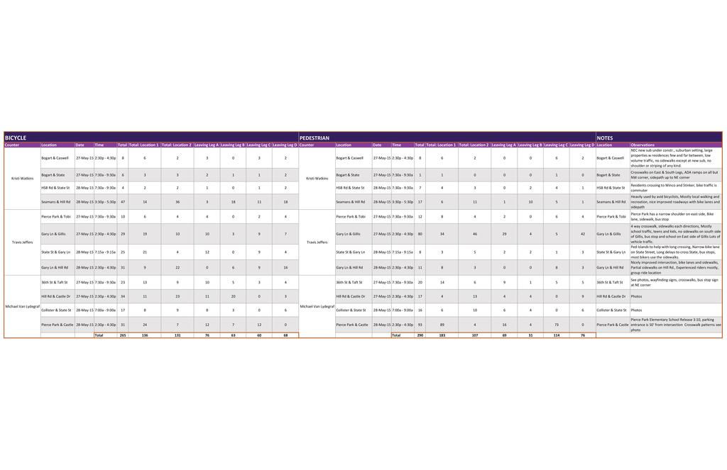
93
94
95 APPENDICES Appendix B: Public Involvement Report NORTHWEST BOISE NEIGHBORHOOD WALKING AND BIKING PLAN
96 APPENDICES This page is intentionally left blank. NORTHWEST BOISE NEIGHBORHOOD WALKING AND BIKING PLAN
97 Purpose of the Public Involvement Report Northwest Boise Walking and Biking Plan Public Involvement Report ACHD Project # J-U-B Project # The purpose of the public involvement report is to identify improvements through direct and web-based interaction with citizens to discuss their issues, concerns and ideas related to pedestrian and bicycle use in the Northwest Boise neighborhood. Public participation is essential in evaluating and developing possible improvements. The public helps determine needs, objectives, resources, constraints and potential alternatives in support of the neighborhood pedestrian and bicycle plan. The purpose of this report is to summarize the public involvement outreach efforts. The report also provides a comprehensive overview of the public feedback received before the May 21, 2015 public comment period deadline. Summary of Public Involvement Activities The Ada County Highway District (ACHD) and J-U-B Engineers/The Langdon Group employed a comprehensive public outreach strategy to identify bicycle and pedestrian improvements in Northwest Boise and understand public support and concerns about potential bicycle and pedestrian improvements. Multiple methods were used to notify stakeholders about the project and invite them to participate in the process. Below is an overview of public involvement/outreach activities that occurred through the public comment period, which ended on May 21, Online Interactive Map On April 20, 2015, ACHD and J-U-B Engineers/The Langdon Group launched an online comment tool, 3P Visual. The 3P Visual is an interactive comment map that allows users to click on a specific location and provide a comment on that location for the ACHD and J-U-B Engineers/The Langdon Group team to consider during the planning process. Public Involvement Meeting/Open House On May 7, 2015, the ACHD and J-U-B Engineers/The Langdon Group team held a neighborhood bike and pedestrian planning Public Involvement Meeting (PIM). The purpose of the PIM was to identify bicycle and pedestrian improvements (e.g. locations for new sidewalks and bicycle lanes) in Northwest Boise and understand public sentiment about any improvements. Outreach Efforts Prior to PIM Information and project details were posted on ACHD s web site including a link to the 3P Visual, which allowed stakeholders to provide comments about the project area during the April 20, 2015 May 21, 2015 comment period. ACHD and J-U-B Engineers/The Langdon Group worked together to identify a comprehensive list of stakeholders with potential interest in participating in ACHD s Northwest Boise walking and biking planning effort. These stakeholders were then informed of project activities through fliers, display boards, s, social media posts, a press release, a display at Boise City Hall, fliers distributed at elementary and junior high schools, bookmarks disseminated at Collister Library, ACHD sandwich board signs within the project area and ACHD web site updates. PUBLIC INVOLVEMENT REPORT PAGE 1 OF 4
98 The PIM was designed for attendees to provide general comments on large display maps of the Northwest Boise project area. Display maps were broken down into four equal sections of the project area. There were two copies of each project area map at the PIM for attendees to denote their top five priorities for biking or walking improvements, in addition to various biking and walking destinations. Valuable insights were gathered about potential neighborhood area improvements and current feelings and concerns regarding the improvements. The Comment Process Attendees provided their comments in the following ways: Attendees were provided with five numbered sticker dots to place on the general comment maps one numbered gold star sticker was used for identifying attendees top priority concern or desired improvement in the project area and four green circle stickers were used for other concerns. Attendees placed the numbered stickers on the comment maps and wrote the corresponding number and comment on a flip chart next to the map. PIM Attendance and Comment Totals Meeting Attendees: 38 stakeholders Comments Received at PIM: 128 comments Online Comments Received prior to PIM: 260 comments (note that some of these comments were located outside of the Northwest Boise planning area). Overall Comment Summary and Analysis COMMENT SOURCE NUMBER OF COMMENTS PERCENT OF TOTAL Online Interactive Map % Open House % TOTALS % Note: As for the 462 total comments, 127 of those comments indicated priorities or destinations outside of the project area. The comments outside of the project area account for 27.5% of the total comments received. All Comments Summary All comments received were separated into four categories: bicycle, pedestrian, both bicycle and pedestrian or other. Comments were further analyzed to specify which major roadways received the most comments in the project area and the issues associated with those geographical locations. In addition, comments were analyzed to determine top priorities for high comment geographical locations. The table below identifies the major roadways, issues associated with those roadways and examples of the top priorities that were identified along major roadways. PUBLIC INVOLVEMENT REPORT PAGE 2 OF 4
99 Major Roadway Issues Top Priorities Hill Road Bogart Lane State Street Collister Drive Taft Street Safety Road width Sidewalks needed Road surface Mobility Safety Traffic lights Sidewalks needed Connectivity Safety Bike lanes needed Sidewalks needed Bicyclist/pedestrian crossings Connectivity Safety Bike lanes needed Sidewalks support & also concerns Connectivity Bicyclist/pedestrian crossings Safety Bike lanes needed Sidewalks needed Bicyclist/pedestrian crossings Reduced vehicle speeds Address congestion at Hillside Jr. High Keep rural feel of Hill Road Reduce vehicle speeds Bike lanes and sidewalks are needed A better turn lane is needed at Glenwood and State Bike paths and sidewalks are needed Accessible routes to bus stops Safe access along State Lighted crossing at Sycamore and State Greenbelt-style path along Farmers Union Canal Sidewalks are needed Themes heard at the PIM State Street is scary for bicycling Hill Road is a popular bicycling route but bicyclist/motorist conflicts often arise (narrow road) Bicyclist/motorist education is needed. Bicyclists do not always play by the rules and neither do motorists. 36 th Street north of Hill Road has a lot of bike/ped and use (golf course, school, sports fields, etc.), and the road is windy with only two lanes (no bike/ped facilities). A suggestion was made for a detached multi-use facility if possible. Signal timing for left turns are problematic for bicyclists. Congestion at Rolling Hills Charter School - needs school zone signs, crosswalks and sidewalks Congestion at Sports Park Complex ADA access needed from Castle Bar Dr. to school on Catalpa Desire for pathway along the canal PUBLIC INVOLVEMENT REPORT PAGE 3 OF 4
100 More directional signs needed Sidewalks are needed on: o o o o o o Taft Collister Hill 36 th Catalpa State Collister and Hill Road Comments: o NO sidewalks, it is rural and sidewalks will ruin the character of the area. o NEED sidewalks and bike lanes as it is no longer rural and is now an active part of the city. Destinations Identified The following were examples of major biking and walking destinations for Northwest Boise as identified by the public: Shadow Hills Elementary Albertson s Walmart Pierce Park Elementary School Catalpa Park/Collister Elementary Collister Shopping Center 36 th Street Garden Center Attachments Top Priority Comments Map Number of Comments Per Road Segment Map Top Destination Map All Public Comments Map Book All Public Comments List/Spreadsheet PUBLIC INVOLVEMENT REPORT PAGE 4 OF 4
101 ^ HILL RD A AM SE N H LC GU Top Priority Comments RD N OR T H W EST B OI SE WALKING AND BIKING PLAN LEGEND H IL ^ UTAHN A RD Northwest Planning Area L ROAD PKWY Parks BOGART LN GILLIS RD GILLIS DR Major Collector HI LL GARY LN ^ ^ DR KENT LN RD RD AL WO RT HS ^ ^ ^ ^ ST MITCHELL ST GLENWOOD ST GODD A DR k k r MCMILLAN RD GODDARD RD IS R TE E ^ ^ ve D ^ LLE NS FER R Y Ri BLV MARIGOLD ST COLL ^ ^ ^ ise DE N E DR Bo CHIN CASTLE DR k COFFEY ST D MAPLE GROVE RD NR GA R RET T ST JO PL I RD ^ k ^ ^ H k CATALPA DR ^ ^ ^ ^ ^ ^ ^ IL L ^ TAFT ST RD 0 2,000 FEET 36TH ST ^ COLLISTER DR STA TE ST ARNEY LN Minor Arterial k CASWELL ST ^ RIVE RSID Schools Principal Arterial k 50 TH DUNCAN LN k PIERCE PARK LN HORSESHOE BEND RD k ^ FIVE MILE RD HWY 55 HILL R D ^ T SUNSET AVE 4,000


102 HILL RD HORSESHOE BEND RD SE H IL N OR T H W EST B OI SE WALKING AND BIKING PLAN UTAHN A RD Northwest Planning Area L ROAD PKWY Parks k Major Collector Total Number of Public Comments RD 0 PIERCE PARK LN GARY LN HI LL COLL k E DR 6-11 DR COLLISTER DR TAFT ST ST AL WO RT HS 50 TH RD RD k k CATALPA DR HI LL RD 0 2,000 FEET KENT LN MAPLE GROVE RD GODD A 3-5 E GLENWOOD ST COFFEY ST MITCHELL ST GODDARD RD r MCMILLAN RD k ve D ER k LLE NS FER R Y MARIGOLD ST I ST 1-2 DR CASTLE DR Ri BLV GILLIS DR ise DE N GILLIS RD Bo CHIN Minor Arterial k CASWELL ST 36TH ST BOGART LN ARNEY LN D Schools Principal Arterial k STA TE ST GA R RET T ST NR LC GU LEGEND DUNCAN LN JO PL I AM AN Number of Comments Per Road Segment D HR k RIVE RSID FIVE MILE RD HWY 55 HILL R D T SUNSET AVE 4,000


103 AM SE A1 Northwest Planning Area UTAHN A RD Y Parks k B2 ARNEY LN Study Area Comments C2 Major Collector GILLIS DR Minor Arterial GILLIS RD STA TE ST k CASWELL ST B3 k C3 C4 CO L L RIVE R SID E DR k CASTLE DR E HI LL EN RD RD BL VD E4 AL WO RT HS T Bike Other k CATALPA DR k D5 RD ST GODD A 50 TH GA R RET T ST GLENWOOD ST MITCHELL ST FIVE MILE RD COFFEY ST GODDARD RD ND D4 r ROVE RD CH I k ve L DR Ri M AP ise DR EG MCMILLAN RD NV IE W Bo MO UN TA I D3 DR LLENS FER R Y R Pedestrian k MARIGOLD ST E I ST JOPLIN RD SHAMROCK AVE COLLISTER DR Schools Principal Arterial TAFT ST HI LL 0 RD E5 SUNSET AVE 2,000 FEET 28TH ST 36TH ST PIERCE PARK LN HI L L ROAD PKW GARY LN B1 WALKING AND BIKING PLAN k DUNCAN LN N OR T H W EST B OI SE RD LEGEND AN BOGART LN HORSESHOE BEND RD HWY 55 HILL RD RD IGH T WR RD Public Input C AR T HIL L L CH GU 4,000


104 SAWTAIL SADIE ECHOHAWK HWY 55 HORSESHOE BEND RD BLACKTAIL SHADOW ROCK BLACKSTONE PALISADES k Public Input NORTHWEST BOISE WALKING AND BIKING PLAN LEGEND Northwest Planning Area Parks Schools DRY CREEK CEMETERY Principal Arterial Minor Arterial Major Collector HILL RD Study Area Comments Pedestrian Bike HALSEY POPLAR BLUFF HILL RD 17 Other PICCADILLY RIDGEDALE 3 HILL ROAD PKWY SILVER BOW RIDGEDALE BRIDGECREEK WATERTON WOODDALE A1 WOODRIDGE k 161 Rolling Hills Public Charter School FEET TIMBERLAND 164 OAKBOROUGH GREAT SKY 18 ARNOLD


105 SILVER BOW GREAT SKY CLEAR LAKE EAGLE ROCK LAKEFORK WATERTON HWY HORSESHOE BEND RD UTAHNA RD SHIELDS ANDY ROY 10 k Public Input NORTHWEST BOISE WALKING AND BIKING PLAN LEGEND Northwest Planning Area Parks Schools Principal Arterial Minor Arterial 180 JENNIE MAYMIE Major Collector Study Area Comments Pedestrian CLAUDIA GARDNER 136 Bike Other HORSESHOE BEND STATE ST WHITBY ELGER BAY LAKELAND KILISUT CARLTON BAY 192 B1 CULTIS BAY ASPEN GLEN WATERWAY MYSTIC COVE CHARLIE FEET HARBOR TOWN SLEEPY HOLLOW ULMER
106 304 ULMER DONNABELL DODGIN DODGIN LEIGHTON 181 BEN 4 MATLOCK MATLOCK MCAULIFFE KATE DEMPSEY DUNCAN LN WATERLILLY STEVE MISTY COVE ROONEY FROMAN HILL ROAD PKWY SLOAN ABE BEN FERRIS DEMPSEY BOGART CASA GRANDE UTAHNA SUNGLOW HOLE IN ONE SUNDIAL SUNSTONE GOODYEAR SUNDISK SUNBELT ROBSON CASA REAL k CHICO CASA GRANDE ROE ROE Shadow Hills Elementary School SEAMAN GULCH HAMPSTEAD RD POWELL PETERSON PRINCE RYGATE HILL HASTINGS k Public Input NORTHWEST BOISE WALKING AND BIKING PLAN Northwest Planning Area Parks Schools Principal Arterial Minor Arterial Major Collector Study Area Comments Pedestrian Bike Other LEGEND 289 SLOAN WATERLILLY MISTY COVE BOGART LN CASA REAL CASWELL ST ROE ELM BROOK COURIER 27 FAIRFAX CASWELL HASTINGS ELM BROOK B ULMER ROE FAIRFAX GILLIS WHITTAKER FEET WAKEFIELD ARNEY LN 141 STATE ST 52 POCONO POCONO


107 CREWE MAIN BARNES ACCESS Public Input NORTHWEST BOISE WALKING AND BIKING PLAN LEGEND Northwest Planning Area HILL ROAD PKWY HILL k Parks Schools PARKCREST DEVONWOOD RYGATE PRINCE PEPPERMILL RYGATE CREWE GARY LN 90 DEVONCREEK DEVONCREEK MAIN BARNES ACCESS Principal Arterial Minor Arterial Major Collector Study Area Comments Pedestrian Bike Other WINTERGARD PIERCE PARK LN Riverglen Junior High School 6 k AMESBURY BELHAVEN ELM BROOK HILL RD AUTUMNWOOD SUMMER HILL HILLGARD B FEET GILLIS RD GILLIS LAMPLIGHTER 331 GLENCREST GILLIS DR RUMFORD 316 PORTSMOUTH ANTLER HILLSBORO 260


108 LAKEMONT WATERSEDGE CATTAIL PANDION STONEHAM OSPREY MEADOWS FISHHAWK ARNEY LN TAYLOR CREEK PANDION 19 BEACHSIDE BOGART LN LAKESHORE STATE ST BEACHSIDE ROE KERRY HASTINGS LIMELIGHT PRESCOTT k Public Input NORTHWEST BOISE WALKING AND BIKING PLAN LEGEND Northwest Planning Area Parks Schools Principal Arterial Minor Arterial RIVERSIDE HEPBURN BOGART PAMELA MANASSAS PEBBLE BROOK WINTERWOOD VICKSBURG Major Collector Study Area Comments Pedestrian BEAVER CREEK EDDY RAPIDAN Bike BAY STREAM POOL SUDLEY CONFEDERATE FAIRFAX BULLRUN APPOMATTOX Other WOODGLADE BLACKBIRD RUN PEBBLE FALLS PEBBLE COVE RIFFLE APACHE C2 NAVAHO FEET WATERWOOD RIVERSIDE DR LAKE FRONT CREEKRUN LAKESHORE BACKWATER MARSH ARAPAHO COVE RIVERFRONT NAVAHO

109 THORTON OLIVER ALDER POINT JONATHAN KERRY LIMELIGHT TOBI CREWE BARON 202 BREMERTON LIMELIGHT TOBI MAY 32 TAMARINDO BARON 31 GLENBOROUGH GLENCREST PORTSMOUTH BARON 330 LIMELIGHT TOBI 259 BARON k Public Input NORTHWEST BOISE WALKING AND BIKING PLAN LEGEND Northwest Planning Area Parks Schools Principal Arterial Minor Arterial Major Collector BLUEBIRD Study Area Comments APACHE WAY RIVERVISTA APACHE RIVULET STRAWBERRY GLENN TRIVIUM GLENWOOD ST GARY LN MARLBORO SAXTON PARAPET GLENBRIER GARDEN GLEN BUNCH ROYAL GLEN GLENBOROUGH GLENCREST STATE ST GLENCREST PARAPET NORTH GLEN 103 LIVERPOOL DEANGELIS FOGGY BOTTOM 58 HERTFORD HERTFORD EDENBURGH SAXTON EDENBURGH OUTLOOK FENWICK PARAPET BATTLEMENT GOLD COAST KANGAROO k 329 PARAPET FOGGY BOTTOM PIERCE PARK LN BATTLEMENT CASTLE DR Pierce Park Elementary School PARTAGAS PARTAGAS 328 OUTLOOK Pedestrian Bike Other C FEET


110 PARAPET PLANO NORTHWALL GOLDIE EUGENE 29 Public Input NORTHWEST BOISE WALKING AND BIKING PLAN HILL RD LEGEND Northwest Planning Area k Parks Schools Principal Arterial 270 Minor Arterial 50 Major Collector 8 Study Area Comments DRAWBRIDGE 154 Pedestrian Bike CRIMSON Other OUTLOOK CITADEL FORTRESS BATTLEMENT HALLMARK HALLMARK BATTLEMENT TURRET HILL OUTLOOK BRIARHILL COLLISTER DR QUAIL RIDGE C4 EUGENE CASTLE DR BLUEGRASS CASTLE HILL 257 GATE HOUSE YORGASON NORTHWALL KENNECOTT STINGER SPRUCE HOLLY HILL POINT BAYWOOD HILLSIDE 303 WILDRYE BITTERBRUSH FEET


111 CHARLESTON NAVAHO HATHAWAY ELLICOTT STRAWBERRY GLENN HERTFORD DUFFERIN CHARM PIERCE PARK LN ELMER ELMER GENEVA Public Input NORTHWEST BOISE WALKING AND BIKING PLAN LEGEND RIVERSIDE DR RIVERSIDE LUCKY FORTUNE FILLY FILLY Northwest Planning Area Parks SAVANNAH PLANTATION LAKESIDE CARLSBAD 101 LUCKY VILLA PARK HACIENDA k Schools Principal Arterial Minor Arterial Major Collector Study Area Comments Pedestrian SHADY BANK DRAKE RINGBILL POINT BAR DRAKE RIVER POINTE MARIGOLD ST MARIGOLD STATE ST Bike Other PLANTATION BECKTON D3 Boise River COFFEY ST PENNY GLENWOOD ST FEET PREMIUM BACKSTRETCH EXPOSITION EXHIBITORS FAIR OAKS

112 BLOOM SORREL ANGELO MINT CENGOTITA MACKENZIE 54 EUGENE LUCKY ELMER EUGENE k k KESSINGER WINFIELD ASHVILLE CRIMSON PORT BAYOU BISCAY PLANTATION KESSINGER YORGASON BLUEGRASS BLUEGRASS GRISSOM LUCKY CASTLE HILLS PEACHTREE OHARA ELLENS FERRY DR CLEARVIEW STATE ST WINFIELD FILLY YORGASON YORGASON COBBLER PLANTATION RIVER LUCKY KEYBRIDGE 130 JOHNS LANDING ANCHOR LOCKPORT Challenger School Cynthia Mann Elementary School WATERWHEEL CLEARVIEW SAMARA ANCHOR CAMBRIA ELMER ELLENS FERRY AZALEA ESTEN HADLOCK REDBRIDGE ESTEN TREDWELL TREDWELL CATALPA MINT BAINBRIDGE CONTOUR HARBOURVIEW SHALECREST JOHNS LANDING WAY WATERFORD HADLOCK KNOLLWOOD WATERFRONT SANDCASTLE MAPLEWOOD MAPLEWOOD EIGUREN 247 EIGUREN HADLOCK COLLISTER DR 105 SAMARA 55 SHIRLEY ROWELL CASTLEBAR CLEARVIEW BLOOM SHATTO LLOYD 324 HILL RD 39 WILDRYE GREER k Public Input NORTHWEST BOISE WALKING AND BIKING PLAN Northwest Planning Area Parks Schools Principal Arterial Minor Arterial Major Collector Study Area Comments Pedestrian Bike Other LEGEND D FEET

113 QUAIL RIDGE QUAIL SUMMIT Public Input NORTHWEST BOISE WALKING AND BIKING PLAN QUAIL HEIGHTS BITTERBRUSH LEGEND WILDRYE QUAIL TERRACE k Northwest Planning Area Parks Schools Principal Arterial GREER 44 GINZEL Minor Arterial Major Collector Study Area Comments 226 Pedestrian Bike FOOTHILL 22 KITSAP Other CASTLEBAR HILL RD TWILIGHT CLEARVIEW BLOOM k CASTLEBAR SAMARA Collister Elementary School EDWARDS SAND CREEK OAK PARK HAWTHORNE TAMARACK 206 TAMARACK WHITEHEAD TH MCGONIGULL BODENHEIMER 224 WOODY TWILIGHT BONNIE CATALPA DR HILL RD 36TH ST k Hillside Junior High School SCENIC D FEET


114 JAMES STERLING PLANTATION RIVER 87 RIVERBEND PLANTATION ROCK CREEK HARBORCOVE AMBERGINA WHISTLER TIVOLI HYACINTH STATE ST HARBOR MARKETPLACE MARKET MERCURIO 80 STOKER NORTH INTREPID STOKER STATION 238 COLLISTER COLLISTER DR COLLISTER 311 BARBERRY SHASTA FORSYTHIA RED OAK k Public Input NORTHWEST BOISE WALKING AND BIKING PLAN LEGEND Northwest Planning Area Parks Schools Principal Arterial Minor Arterial Major Collector ELAYNEA CODY BEACHFRONT SILVERLAKE MAGNOLIA Study Area Comments Pedestrian Bike Other 51ST LAKEHARBOR LAKE RIVER WYLIE ROWLAND E4 WYMOSA SAINT JAMES 50TH ALWORTH ST MACONDRAY ALAMOSA FEET 50TH ST 49TH MYSTIC COVE WILLOW

115 34TH WOODY GARDEN CENTER 323 Public Input WOODY SHASTA BERRY SHASTA LASSEN HILL RD 34TH 33RD STONE CREEK SYCAMORE 215 HAWTHORNE TAMARACK MAGNOLIA 34TH FORSYTHIA 33RD 32ND 39TH 213 GERRARD TUCKER TREASURE NORTHWEST BOISE WALKING AND BIKING PLAN LEGEND Northwest Planning Area FORSYTHIA PINEHURST 36TH ST STONE CREEK k Parks Schools Principal Arterial Minor Arterial Major Collector Study Area Comments Pedestrian GERRARD Bike Other BARR SILVER PLUM TAFT ST WOODY BARR WYLIE 35TH 34TH CANTERWOOD 33RD EDGEMOOR 32ND E5 INNIS STACY PLANT NEFF ARTHUR 38TH WOODY BELLOMY FEET PINE STATE ST HANSEN WILLOW FARGO BUSH BUSH 31ST 30TH SMITH BURKE
116
117 Comment Type Inside Study Area ID Comment The East side of Horseshoe Bend Road needs sidewalk and bike lane to safely access Rolling Hills Public Charter School (a Kindergarten-8th grade school) from the neighborhoods to the South and East of the school. Improvements here would also allow better access from these same areas to the Optimist Sports park. Currently the area has little to no shoulder and barrow ditch. Intermittent stretches of gravel frontage road do not all connect and do not reach all the way to the school or park. The speed limit on the section of Horseshoe Bend Road in front of the school is too high for children to safely walk or bike ride on the road edge. As a teacher at Rolling Hills Charter School, I worry about our students who walk on this very busy road. A walking/bike lane would help ease safety concerns tremendously. I would also love to see this become a school zone with decreased speed limits during beginning and end of school hours. As a parent of two children that go to rolling hills I am very concerned about the 4 way stop that frequently I see folks forget to stop and the missing sidewalks to the school for kids to walk safely to the school. In addition, I frequently see some folks speed or go faster then posted speed limits making getting in and out of the school a challenge. During school times there should be a school light that limits the speed on horseshoe bend road. Please consider side walks, reduced school hours speed limits and better access up and down the horsebend/hill road connections to the school. I am a parent at Rolling Hills Charter School and a resident at Floating Feather Mobile Home Park. I am concerned that we are the only school that does not have the school zone flashing yellow lights, side walks or a cross walk that goes from the lights and proper cross walks that cover to the floating feather Mobile Home Park. Thank you. These areas are so dangerous Sidewalk from Catalpa to State would be terrific, much safer. Sidewalk all the way to Hill Rd. Would be great, too, but seems Shadow Hills Elementary Bogart needs side walks and bike lanes. There is a lot of new development but no improvements to 4 driveway of floating feather to the other side of the road. The kids walking home from school have to cross a heavily traffic/high speed road to get to their homes at floating feather. Please put in sidewalks on both sides and school zone flashing for our children. 5 less likely. No one in their right mind could call the Catalpa to State portion of Collister a quiet little country lane, as people did when the sidewalk issue first came up years ago. Ped 6 Wide, well marked bike land. Bike 7 A safe bike and pedestrian crossing is needed. 8 Would love to see the Farmer's Union Canal road turned into an official walking path. Ped 9 the area. This street is fairly narrow and has no safe place to walk or bike and with new development and being close to a school you need sidewalks at lest. 10 Please don't put in any sidewalks in this area. We like it as is. Other
118 Bike lanes on HSB road from the Hill Road Pkwy to the Winco area would help; reducing the speed limit on this stretch would help was well. Bike Bike lanes from the hill/collister intersection to the turn to Quail Ridge would help bikers and pedestrians that are heading to the Polecat Gulch Trailhead. The edge of the road is very narrow after the sidewalk ends, going north. Bogart is in desperate need of sidewalks...new developments and more kids for Shadow Hills Elementary should make this a priority. Side walk on Sloan from Bogart to Shadow Hills Elementary on the south side of the street would be a huge safety benefit 15 Sidewalks and/or bike lanes are needed on Taft. It has become a significant pass through street between the Collister shopping center and 28th for commuters and other traffic, and it is also widely used by children and other pedestrians and cyclists. Taft don't understand why the Sunset neighborhood gets so little attention, when so many kids in that area routinely ride and walk I am a serious cyclist that will ride on most roads. HWY 44 is NOT one of those streets. I rode on 44/state once or twice but Narrow road with fast traffic and increased development = need for sidewalks 16 elementary students use it to walk and ride to school. This street seems to be on the outer boundary of the area of focus. I for many reasons, not just school. 17 There is about 40 feet of curb south of the canal bridge that forces cyclists further into the road or onto the ""sidewalk"" Bike 18 Bike lanes would make an improvement between Hill Road Parkway and 44. Bike 19 didn't feel safe. There is not a wide enough area of refuge on this road, especially for the speed limit and how busy it is. As a auto commuter I wouldn't want the speed reduced, but a better bike lane could help, although all of state street has this challenge. Bike 20 Agree...definitely in need of a bike land and possibly a sidewalk on HSB Road between State and Hill. 21 a bike lane along taft in both directions is totally appropriate given the level of traffic and the types of use. 22 when it comes time to chip seal hill road do not chip seal the bike lane. keeping this portion of the surface smooth will definitely help is separating the bike traffic from the car traffic. Bike 23 the recently reconstructed canal bridge does not allow for a consistent bike lane on the east side of the road. restriping or reconstruction to allow for a consistent bike lane are appropriate and necessary. Bike 24 Collister is widely used both bike and foot traffic. It would be nice to feel safe while walking and biking with designated sidewalk and bike path. 25 I can never trigger the light here at 36th and Hill when I am on my bike. Please do not say a roundabout is the answer, as I've traversed the one on Whitewater Blvd and it scares me to death Bike
119 Ped The new light at Bogart and State is a welcome addition for cyclists. No more frogger. It's a very direct route through the Bike The intersection of Hill and Castle can be busy. Friday's are difficult due to a homeowner proudly putting their trash/recycle Bike Bike I believe some in ACHD are opposed to bike lanes on State St., but it's often the most direct and practical route for cyclists Rolling Hills Public Charter School is in this area. I feel a sidewalk and a bike lane are pertinent to have in front of and near a Traveling from 30th & State to Flying Pie, 20th Century lanes, & the collister shopping center. It is a very dangerous area for Ped 26 subdivision to get on the greenbelt. The crossing is a bit unfriendly however. In order to trip the light going south, a cyclist needs to cross to the wrong side of the road and then come back. Not safe. 27 The trees need to be trimmed on the sidewalk here. An adult cannot ride or walk under without ducking or going onto the road or lawn. 28 carts in the middle of the bike lanes even though there is room to keep them off of the asphalt. Dangerous for cyclists to have to dart around these obstacles. 29 A wider bike lane is needed. Probably not possible. BUT ticketing the cars that are parked in the bike lane in this area would be helpful. 30 travelling east or west w/out diverting to Hill or Greenbelt. Businesses along State would see improved atmosphere and yes, increased business 31 This section of sidewalk always has weeds growing out into the walking portion of the sidewalk. Fences come right up to the sidewalk and the property owners don't do anything about the weeds. 32 Roots have come under sidewalk and one side is 2-3 inches higher than other side. 33 school for children within walking distance to be safe. In addition, there needs to be a flashing sign marking the school zone and warning drivers to decrease their speed. Other 34 bikers and pedestrians traveling along State Street. Also, immensely inconvenient when traveling without a car because of the seemingly constant closure of the greebelt. Please put sidewalks, bike lanes, and pedistrian overwalks for crossing state street I second the comments reported about Taft St. Sidewalks need to be added or connected between 36th and Sycamore, so that pedestrians can safely travel on this road. I walk to the collister library with my two children along Taft, and I don't feel very safe doing it. Collister needs sidewalks for all the students walking to school, bikers and pedestrians. We use Collister to get to the library, post office, bank, and green belt. I don't feel safe riding bikes with my small children on Collister and we moved to this area to be closer to the greenbelt. I cannot believe ACHD is considering re-doing the State St and Collister intersection without considering putting in sidewalks. It's going to bring all types of more traffic and it's only a matter of time before someone gets hit by a car. It would be great if achd would do something proactive here. If sidewalk on one side only like Pierce Park.
120 Tons of bikers, walkers, and speeding drivers on this road. Needs a sidewalk badly The side streets off Taft are quieter and I 37 Tons of bikers, walkers, and speeding drivers on this road. Needs a sidewalk badly The side streets off Taft are quieter and I This section of Hill Road needs wide enough bike lanes on both sides and a sidewalk on at least one side. Far too many cars I think a wide, non chip sealed bike lane on Hill road would be great. Some issues I see are parked cars, trash cans, and debris The Hill Rd arrangement is a fair compromise among all users and ACHD does sweep it often, the adjacent landscape plantings One alternative to accommodating pedestrians and cyclists on N Collister Dr is to make a greenbelt-like passage along the The bike lanes are adequate, but in places vehicles park in the lanes. Unfortunately this past year, a cyclist ran into a parked don't think need sidewalks. Taft would feel a lot safer with a sidewalk. We walk along this road almost daily and it requires constant vigilance. 38 don't think need sidewalks. Taft would feel a lot safer with a sidewalk. We walk along this road almost daily and it requires constant vigilance. 39 park willy-nilly on Hill. I and others use Hill as a major commuting corridor to downtown by car and bike, as well as for for recreation. 40 please make the Gary Lane & State Street corner safer to cross. High traffic 41 or water in bike lane. Hill road is a major route for Cyclists for fitness and downtown commuting. Lets make it as bike friendly as possible. Thanks for taking input. Bike 42 Intersection of glen wood and state needs attention for safety of cyclists and pedestrians. We cycle and walk to local businesses and stores including the garden city post office and farther south. Attention to sidewalk (non-existent) and bike lanes just south of riverside drive would be appreciated. 43 While N Collister Dr. has wide shoulders along much of its length, parked vehicles often push pedestrians into the traffic lanes. The sidewalk and shoulders very inconsistent along both sides. 44 usually grow into the south side bike lanes each spring, including thorn bushes and should be kept trimmed back--perhaps the property owners' responsibility. 45 Farmers Union Canal connecting with Maplewood Dr. This would likely be politically challenging but would provide a nice amenity for NW Boise and could link with the much desired rework of the Collister/State intersection. 46 Sidewalks should be added on the N side of Hill Rd between the Hill/Castle intersection and N Collister Dr. 47 W State St is very unsafe for all non-motorized users. Like it or not, it is the key corridor in NW Boise and should accommodate all users. 48 This road needs a sidewalk, pure and simple 49 You tear up good sidewalks west of here and you don't EVEN HAVE SIDEWALKS BETWEEN COLLISTER AND 26TH ST. Put a decent sidewalk in before you tear up any more good sidewalks west of there 50 vehicle across the street from our home. I would prefer a parking restriction along this busy vehicle and bicycling corridor, at least where there is only room for a bike lane. Bike
121 Bike This stretch has a curve and the bike lane is very narrow between Pierce and Gary Lane. It would be nice to have a wider bike lane as it seems to go from good to none in this section. Also, please designate no parking on Hill Road where bike lanes are. A person ran into the rear end of a truck at high speeds coming around a corner right in front of our home. Thankfully, she was only moderately injured. I am trying to reach the foothills to the north and the Greenbelt to the south. Ped and bike improvements are needed along one entire side of Bogart Lane (specifically, on Bogart Lane that runs from State Street to the original Hill Road). The current barriers are cars that drive VERY fast Additionally, the volume of cars has increased greatly now that there is a street light at Bogart/State. A lot of people use Bogart Lane. Also, drivers, walkers, bikers, etc. going to/from Shadow Hills Elementary use Bogart as the main thoroughfare. Frankly, I am surprised there isn't already a sidewalk. I understand the with the development in the area that is taking place, there will be additional sidewalks, which is great. I am still concerned that they won't be connected and there will be sections of Bogart that still don't have a sidewalk. Ideally, there is one continuous sidewalk and bike lane for safe, efficient travels for everyone. As several others have suggested, especially as its motorized traffic grows, a safe route immediately adjacent State St. must be This small section of land needs sidewalks. Many children attending Pierce Park Elementary live on the east side of the street. Collister is one of the busiest streets for suburban living, and to be quite honest, it's not near safe enough. Sidewalks are fairly 53 Bogart Lane needs a bike lane and a sidewalk along the entire length 54 provided for non-motorized users. I ride from the East End to the Primary Health offices. State St. is the fastest, most direct route on a bike. Even if I take the Greenbelt, which is out of the way but less nerve-wracking, I must deal with State St. for some distance. Bike 55 Bike route signage is essential for east-west connections between Hill Rd & State St. E.g., Catalpa-Bloom; there could be others using unmapped pathways. Bike 56 As a child approaches the stop sign at Piece Park and Castle Drive there are no sidewalks and a very small shoulder. Children are essentially walking in the road. They need sidewalks right in this small stretch. Otherwise the kids will keep running across the middle of the street. Ped 57 nonexistent, the speed limit NEEDS to be lowered to 20mph or significant amount of speed bumps added, and people race up and down that road at all hours. Most notably, these things must be addressed for the vast amount of children in the area. 58 Sketchy at best. This entire corner is designed for cars and cars only. The large traffic box and mishmash of utility poles etc make it a very dangerous corner. Standing on State crossing Collister is dicey. The light on Collister is also too slow. Making it a very long wait to cross the street. I cringe when I see impatience set in causing jaywalkers who underestimate the speed of vehicles at that intersection. The greenbelt is not labeled very well either.
122 59 Maintain the charm of what makes Hill Road a special place by not adding any width or sidewalks. I walk, bike and drive the I ride my bike up collister heading south. It is unsafe heading south. when there are cars parked along the road or low hanging Agree with all comments about this stretch between Pierce Park and Gary. What a missed opportunity with the new pavement Horrible missed opportunity with the new paving job to not make this section from peirce park to Glenwood wider. The bike lane from Bogus to Hwy 55 should all be the same size -- cyclists don't pay attention to when the road narrows and widens -- Bike Wider bike lanes from Pierce Park to Gary Ln. This section of Hill road does not allow for the 3' bicycle/car rule with on coming traffic. Bike 60 With all of the pedestrian traffic on Collister, it would sure be nice to have it look and feel like the new 27th st. 25mph with bike lanes and sidewalks would be fantastic 61 road daily and see no need for change. Hill Road should not be treated as a fitness or motor path for residents who live elsewhere - it is a charming residential street that Boise has far too few of. 62 Thanks for the light. Unfortunately, there isn't a safe way for a cyclist to activate the signal. Currently one has to cross the road, press the signal and than cross back to the correct lane. Kind of a dangerous situation Bike 63 Crossing state can be a little dicey. Is it possible to give just a bit more room for the bike lane? Bike 64 branches, you have to swerve into the roadway. I also drive this area and skate boarders and other bikers are doing the same thing. Make this a bike friendly corridor. Bike 65 that just went in here They widened the road and this morning the lanes were just marked only to have the bike lane just as narrow or practically non-existent in the same areas as it was before Bike 66 which they should -- but riding like I do with several groups -- they never pay attention. Having more space in in the narrow section would have shown that the city actually was paying attention to conditions Heading northwest from State Street. Let's find a way to offer liability protection to the Farmers Union Canal, and use the ditch road for a walking/cycling path. Catalpa to Ace Hardware/River. Very hard to cross State Street. Perhaps a landscaped median would make things easier? Bike I cycle on Taft with my kid to reach the Collister shopping center. The sidewalk just ends, and the road narrows. During rush 69 There needs to be a sidewalk on the north side of the street on this part. This is the neighborhood access to the bus stop (which is also used by students). This segment is wide enough to accommodate a sidewalk without even getting an easement years ago. I have both been involved in, and have witnessed close calls between Ped's and MV's several times over the years. Ped hour, some people drive pretty fast through here too. I like the narrow, slightly winding road, but some consistency with the sidewalk would be nice. Bike 70 Sidewalk is broken in front of Owens Park. Not really a problem, but doesn't make much sense. Bike 71 from the home owners on the north side. It should have been done when this portion of the street was reconstructed several
123 Having lived in this area for 30 years, I like Collister the way it is. I will voice opposition for any changes that is going to screw it up like Catalpa (i.e. lowering the speed limit by doing a speed study while the construction signs were still up and metal plates were still on the roadway), or the half baked job that was done on Pierce Park, north of Castle Dr. I am generally in favor of the work ACHD has done over the years, but your issues I list above seem to have been because of politic pressures (i.e. Mr J.F.) and not good engineering decision. As a matter of bias, I do drive, walk, and bike down Collister regularly. Only issue over 30 years is broken glass from ignorant persons. I agree about the need for sidewalks on Taft. I cycle down the road every day and feel safe enough myself but always feel like it could be safer for pedestrians given the volume of traffic. The entirety of State St. is in dire need of better cycling and pedestrian infrastructure. The excuse that it's just for cars no longer cuts it given the constant use by non-motorists every day. It could be much safer. My neighbor on N36th street is completely blind. He needs sidewalks so his seeing dog knows what to do when they walk 3-4 times a day. Currently he cannot get to Collister Shopping Center so he is limited on his shopping and eating. I also live on N 36th and I would like sidewalks along Taft. This is a heavy pedestrian/biking area that is very dangerous and yet we all use it to get to shopping center by foot. ANY sidewalks in the area would be much appreciated The speed and volume of traffic on State North (Catalpa) seems to increase each year, this is not designated as a collector street but a significant amount of car and truck drivers use this street to connect from State to Hill or 36th. School, park and lots of kids on this narrow road will be deadly some day Its dangerous for bikers going east. Something needs to be done between Hill Road Parkway and the north side of the canal. The road is WAY too narrow there for both bikes and cars. Bikes have room to stay in the bike lane part way up the hill, and then end up swerving into the traffic lane because the bike lane disappears. They have the choice to go into the traffic lane or the pedestrian area without adequate warning to get moved over. The whole setup is dangerous. The bridge over the canal was widened, but the road was not made wide enough for a bike path as well as a roadway. Not very smart planning. Bike Bike Ped Bike Need a pedestrian/bike connection between Ellens Ferry Dr. and Bloom. It would make safer, faster and shorter connection 78 Hill Road between Pierce Park and Gary Ln is too narrow in places. We need north-south bike routes to better connect north (NE, North, NW, Eagle) to the rest of Boise. Bike 79 How is lowering the speed limit and adding sidewalks going to screw up Collister? 80 A protected bike path on State Street is needed. State Street has many businesses that I could reach by bike if only there was a way to get there safely. Bike 81 between the Greenbelt and businesses on State st to the neighborhood behind it. It would re-rout pedestrian and bike traffic from Ellens Ferry and State
124 Other 82 City and ACHD approved a ridiculous curb instead of sidewalk for corner owner to develop his property to add density. Intent Sidewalks are almost nonexistent or unsafe for both pedestrians and bikes. Bike 83 need more speed bumps on Ellens Ferry. People drive too fast while children in the area. Bike 84 was to preserve park-like atmosphere, not put a hard raised curb. Even a real sidewalk would be better Cycling with kids from Collister to Pierce Park, Johns Landing/Elmer is such a nice route. Much better than Castle. It's quiet, calm, and meanders pleasantly. Perhaps some route markers would encourage its use? Bike We really appreciate the little paths between Tamarack Dr and Sand Creek St. They save a long round trip, make Edwards Greenhouse more accessible to the neighborhood, and promote pedestrian traffic. Let's have more of this sort of thing. Ped This little pathway is so convenient, and in combination with Plantation River, makes an excellent, scenic, safe and quiet cycle 87 Bike Hill Road is currently the bike route for many bicycle enthusiasts. Time to treat this road like a primary bike road. Create a ride from the Sycamore neighborhood down to the river and greenbelt. Let's have more of these micro paths. 88 Truly a useful little path Bike 89 Side walk (bike) for student and parent access to River Glen JHS. 90 demonstration project for the greater Boise area to learn from. Make room for pedestrian foot trail, dog baggies, trash cans and landscaping 91 Create a less dangerous bicycle route on Hillside Avenue past Collester Drive through the open land between Collister and Briarhill Dr connecting to Hill where there are better sight lines. 92 We need sidewalks and bikelanes all the way down to the shopping center and library. It's unsafe as it is. 93 This crossing of State street is totally unsafe for pedestrians and bicyclists and needs to be ACHD priority to get this fixed as soon as possible. 94 Would be nice to remove the metal barriers at this location because bicyclists and women with strollers cannot get through. 95 We need bike lanes on Catalpa. Bike 96 We need better crossings for pedestrians and bicyclists at Bloom and Johns Landing. Also, sidewalks. 97 I've lived in this area for 8 years and I desperately want change. I don't care if people voice opposition. It's hard to protect yourself from cars and it's really unsightly. Please change Collister. 98 Please add some kind of route direct to the Greenbelt. Please add better lights for Ped only or Bike only or BOTH. PLEASE. 99 Boise City police need to ticket vehicles that park on both sides of Gillis in the No Parking areas during sports events. There is a lot of traffic, people pulling trailers, bicycles, pedistrians, people walking dogs, etc. Someone is going to get hurt
125 Ped Please add a crosswalk at this location. It would improve access to Shadow Hills and Magnolia Park which will be built to the 100 Bike lanes on 36th St need to be widened Bike 101 There are not enough adequate sidewalks along the north side of State St. Between Hwy 55 and the North End 102 west of the school in Currently those walking along Sloan must pass the school and come back, as there is no sidewalk on the south side of Sloan. Ped 103 Make a pedestrian pathway connection in this area to improve access between Gary and Pierce Park. There are very few bike and pedestrian access points between these two roads. The stretch on Taft between Sycamore and Hawthorne is dangerously constricted. It is narrow and bounded by irrigation 104 Provide a pedestrian signal in this location to improve access to the Collister Shopping Center. Many people cross in this area. 105 Add sidewalks to Collister. As a child I was never allowed to use Collister because my parents said it was unsafe. It has not changed since that time 20 years ago. A continuous sidewalk is important in this area. 106 Barriers to biking and walking: There is no sidewalk and the shoulder is very narrow-- very dangerous to walk or cycle along State St. There are many businesses in easy reach of my house, but I have to use my car 107 ditches--so it is impossible to safely walk off of the road. There is not enough space for 2 cars and pedestrians to pass safely. I regularly walk or ride bikes to the library with my kids and feel like this section of Taft is very unsafe Taft is in need of safe pedestrian and biking lanes. This street receives heavy bike and pedestrian traffic, as well as heavy vehicle traffic because many drivers use this as a short cut between State St and 36th, or simply to enter the neighborhood. I live on Taft and witness that the majority of pedestrian and bike traffic are children These children are often traveling to and from the library or the dollar store. Taft between Sycamore and Hawthorn is dangerously narrow. Just enough room for two cars to pass on the roadway (30ft ROW), but the shoulders are sunken irrigation ditches providing no place for pedestrians. This is not a safe place to walk or bike. I think Sycamore between Catalpa & Taft needs sidewalks. Lost of ped traffic to/from Collister Elementary, Hillside Jr High, the Good Samaritan Home and the Park. Street is often filled with bikers & walkers trying to dodge fast moving cars. Especially dangerous when it rains, as the puddles extend most of the way across the street, leaving NO room for peds. My concern is on Whitehead Drive. There are no side walks and there is an extreme amount of traffic cutting thru this street to avoid the congestion at Hill and 36th, especially in the mornings as school is starting. You children live on this block and many kids walk this street in order to get to school. I would like side walks, or signs to slow down for pedistrian safety, or block the end of Whitehead at Hill road.
126 My concern is on Whitehead Drive. There are no side walks and there is an extreme amount of traffic cutting thru this street 112 Taft, from Sycamore to 36th street, is heavily used by pedestrians and bikers. Often they are small children. This area could I would like to see sidewalks added to Collister Dr. from Hill Rd down to the Library at State Street (on both the West and East sides). Sidewalks in this area would make me feel safer allowing my children to walk to Catalpa Park and the Library without adult supervision. I didn't like the options ACHD shared last time which would have taken away shoulder parking on one or husband and elementary aged children have safely biked up and down Collister without any bike lanes, so I don't see a need Bike to avoid the congestion at Hill and 36th, especially in the mornings as school is starting. You children live on this block and many kids walk this street in order to get to school. I would like side walks, or signs to slow down for pedistrian safety, or block the end of Whitehead at Hill road. Ped 113 Catalpa Dr really should have bike lanes on BOTH sides of the street Bike 114 use a sidewalk on at least one side of the roadway to safely accommodate walkers, and a bike lane for bikers. The traffic and speeds are also a cause for concern. 115 both sides of the street and also interfered with some home owners wells and maybe "set-back" regulations as well. My for something like the 5 foot wide bike lane on both sides of the street previously proposed I'm not sure if it is possible due to the proximity of the foothills to Hill Road but it would be great to be able to walk or bike to Hillside Jr. High from the Maplewood/Collister area a little more safely. Having a sidewalk on at least one side of the road would be terrific It would be helpful if the bike lanes could remain in that area too. In its present state, the shoulder is either too narrow or filled with water filled potholes for students to walk safely year round. A crosswalk is needed at the intersection where Hill Road and Castle Drive meet at the East end of Holly Hill Dr. I see many elementary students trying to dart across the street in this area both in the morning and in the afternoon. I realize there is a crossing near Turret Way but honestly most students aren't willing to back track to use that crosswalk when they are headed East. Ped Sidewalks would be a great addition on the North side of Caste Dr/Hill Rd from Stinger Dr. to Collister Dr.. Cynthia Mann does have students who commute on foot that could benefit from having the sidewalk extended in this area. That sidewalk extension would also be used by Hillside Jr. High students who are walking home from after school activities. Ped If the roundabout is actually created by Hillside Jr. High, please install one of those pedestrian activated crosswalk signals which would have all directions of the roundabout pause while people crossed the street. Junior High students can be as young as 11 or 12 years old and might not make the best choices when trying to cross and land on some sort of pedestrian medians. I imagine there are also elementary aged children from Collister in that area. Ped
127 A crosswalk needs to be added here. Currently kids are asked to walk all the way to Robson Avenue to cross the street to 120 Bogart is in dire need of both sidewalks and bike lanes. I see kiddos walking to school every day on this road with cars zooming past them. 121 I have always wondered why there are no bike lanes on State Street. I see people riding their bikes and walking on State all the time and it is so scary to see high speed cars zooming by them just inches away. 122 Bike lanes and/or sidewalks are needed on Duncan for safe travel, especially with increased development happening in the area. 123 Agree with others- the sidewalk ends right near Winco and past that point there is not a safe bike lane or place to walk heading North on HSB Road. 124 A bike land and sidewalk would greatly increase safety along Bogart Lane. Many children walk along this street to school and must walk in the road. 125 Shadow Hills Elementary. This is so ridiculous that a lot of kids have understandably stopped doing that. Plus there is a very large bike parking area here that doesn't receive much use because the kids are told to cross at Robson Avenue Our family often bikes, runs, and walks on this section of Taft, and it is not very safe. It is also a frequent route that kids take to the local library and to local schools. Vehicles travel fast, and it's narrow. A sidewalk here would be very good. Adding a sidewalk to the east side of Collister from Hill Road to Catalpa would assist Collister Elementary School students in getting to school safely. I think many Collister residents would like to keep the shoulder parking and not wind up living on a street like 36th where there isn't even a good, safe for pedestrians/strollers/cars spot to place garbage/recycle on Fridays. Ped Ped The walking path on the west side of Pierce Park is really nice. Would it be possible to add some speed bumps to this section Ped Hill Road should be widened to accommodate bikes, pedestrians and vehicles. As it is, there is no space for pedestrians, 128 of the street? Motorists turn the corner and floor it to get up to speed. Speed bumps would help regulate the speed on this long straight-away. Thanks 129 A pedestrian light would be great for students and parents to cross safely. Lots of heavy traffic including garbage trucks travel this road. 130 I also recommend a bike/pedestrian pathway between Ellens Ferry and Bloom. It would provide a direct route to the Greenbelt for people north of State Street. 131 Collister needs sidewalks and bicycle lanes the whole way from State to Hill Rd. People drive way too fast and it's not safe for the people that are forced to walk on the roadway due to lack of sidewalks. 132 except to walk in the bike lanes. The bike lanes are too narrow, forcing bikes and vehicles into close proximity. This is particularly an issue between 36th and Gary Lane. 133 Sidewalks and bike paths near the school.
128 141 From Glenwood to Horseshoe Bend needs consistent sidewalk/bike lanes. People riding bikes and walking along the edge of the road while cars whiz by at mph. 134 This reach of Taft St. from Sycamore to Hawthorne is an extremely dangerous stretch of road with very high pedestrian and bicycle use. The road is too narrow and the speed limit of 25 is too high. There are trees that obscure the clear view that that turn onto Taft have sight obstruction and an angle that encourages excessive speed. Taft is a major collector of folks Not only does Taft need sidewalks and bike lanes but speed bumps As a major connector from 36th to State St, this road is Way over due. Shame on ACHD Should have been done when Rolling Hills was built. Should have been done when Optimist Park was approved, along with center turn lanes for both the school and park. Should have been done when Farmers Union Canal bridge reconstruction and road widening was being done. Those of us that live next to and use Horseshoe Bend Road (HSB) and Hill Road daily see many dangerous, potentially deadly encounters time and time again. The speed limit does NOT need to be changed. The roads, sidewalks/gravel areas/bike lanes need to be corrected as they should have been before the other construction projects (school, park, and bridge) were completed. How did the park and school get approved/built without adding turn lanes, center lanes, sidewalks and ΓÇ green areas/safety cushions ΓÇ between sidewalks and road as all other construction/development projects are always required to do, as part of the county/city impact area approval process? those that walk to WinCo, Home Depot, Pet Complex, Ridge Line bike shop, Sport Clips and the Stinker Station. When the Horseshoe Bend Road was widened at the bridge, instead of standing up for the citizens that use the road, ACHD did not want to fight with the City of Eagle nor the property owner of the open gravel pit on the West side of Horseshoe Bend Road for the Right-A-Way for sidewalks and bike path, they opted to buy and take the Right-A-Way on the East of the Horseshoe Bend Road, ΓÇ because it was easier, cheaper and less hassle.γç ItΓÇÖs time to STEP UP ACHD [employees] and do the right thing sidewalk Ped 135 Identify areas in undeveloped land where walking/biking paths can be required of new development that are separate from the streets and cars. 136 This is a confusing intersection, especially at night. Better street lighting is required. Other 137 violate city code. Sidewalks, increased width, and a three way stop is highly encouraged. Cars traveling north on Sycamore traveling to State Street from the West. Bike 138 heavily used by cars that regularly exceed the posted speed limit. I am extremely discouraged by people regularly going 40mph plus on this reach of Taft. Other 139 West of Pierce Park there is a sharp corner and hardly any shoulder. I always feel very nervous through here. Bike 140 Hush$$$? There are hundreds of bicyclists, individuals, couples, kids, groups and clubs that use HSB Road and Hill Road daily. Weekends are extremely busy with cycle traffic along with all that is happening and traffic generated by the park, school and in a timely manner, too
129 I lived in a neighborhood on the Bench where there was a lot of opposition to sidewalks. Once the sidewalks were installed, The majority of people opposed to this are people who donγçöt have children (or their children are grown) that attend local Taft street is very dangerous for pedestrians and cyclists alike in it's current state. We have to walk or bike on Taft with our Ped I echo the comments of others, Taft needs sidewalks, tons of kids walk/ride to school and lots of pedestrians/bicycles/dog 142 everyone loved them Our property value increased, and all of the children in the area were much safer. Please add sidewalks and bike lanes to Collister. 143 elementary/junior high schools. These same people are the ones that choose to park on the street instead of in their own driveway. We all have a garage and drivewayγçªplease use them. Our street could really benefit from sidewalks, bike lanes, and a lower speed limit. 144 I enjoy walking my dogs along Elmer St. because of the shade and seeing the animal life. However, there are no side walks or safe areas to walk with cars are passing by. 145 kids in order to get to the library, but each time feels like we're rolling the dice with our kids safety. 146 Sycamore is a popular walking route for kids going to school, dog-walking and route to Catalpa Park. It would be much safer with sidewalks. 147 This are needs bike lanes and sidewalks. There are often children biking or walking to school on the very thin shoulder of the road. 148 There is not enough space for bikers and cars to coexist safely. These blind corners increase the likelihood of accidents. We need a dedicated full width bike lane. Sidewalks would be nice. 149 Missing small section of sidewalk causes pedestrians t o have to walk on the road with no shoulder. This is an easy fix that will greatly improve safety. 150 walkers, etc utilize this nice quiet street. I would recommend road bumps on Taft in addition, to keep cars paralleling State Street at 25mph. 151 Sycamore, Hawthorne,Tamarack and N. 39th streets all need sidewalks. 152 An overhead pedestrian bridge would be very well utilized here. 153 At least one side of Collister should be a better option for pedestrians. It is a feeder to schools and bus routes. I don't think these N/S streets between Taft and Catalpa need sidewalks or bike lanes. There is plenty of space and if cars 154 This section of hill road needs to be turned into a dead-end. It's too narrow to support the traffic load and bicycles. Bike 155 As a Catalpa resident, I'm terrified of how fast the cars, trucks and city bus travel on this street. Sidewalks have helped but not for kids crossing and bikes. One stop sign or additional speed bumps would help. 156 A safer and better marked crossing for the greenbelt. 157 follow the 20 mph speed limit, we are usually comfortable walking as a family. Focus on Taft and the major intersections/streets.
130 158 For one thing, a road that goes past an elementary school at a fairly quick descent down a hill (west bound) needs a slower Rolling Hills Charter School is a public charter school. This road needs to be marked for School Zone and the sidewalks will be safer for students coming and going from the school on foot and bike. During the Spring and Fall Optimist fields are full of Elmer St. is a narrow country lane. A semi-rural area with 1/4 ac. to 4 ac. lots. Any addition of sidewalks will change the entire Continue the improvements on Bloom. This is a great feeder to the greenbelt. 159 Catalpa needs bike lanes. It runs right in front of a school - kids need bike lanes for safety, at least. Bike 160 speed limit. Post as 35 mph, most drivers go at lest 40. Reduce the speed limit. And add some occasional enforcement (which might help with the graffiti problems) Other 161 youth and parents. The area is needing to be safer with slower speeds. We have partnered with Boise and ACHD for flags at the intersection of Hill and Horseshoe Bend. Rolling Hills pays for the flags and their replacement. We need one in front of the school too. This is a critical safe zone that needs addressed with proper planning for childrens safety. 162 Students and youth athletes need to be kept safe by adding sidewalks. Reduce the speed in front of the school Ped 163 Keep the kids safe at the school and going to the park. This is an area that needs attention NOW Ped 164 Kids walk down the ditch to get to school and it is unsafe at the road. No sidewalks exist in this area, yet the school has the sidewalk extending to connect when ACHD gets on board. Safety first Ped 165 character of the area. A similar attempt was made previously with overwhelming neighborhood rejection Rolling Hills initiated the flags for the pedestrians at the crossing. Also, got the sidewalk crossing to be put in crossing Horseshoe Bend Rd. Rolling Hills pays for the flags to be replaced at the intersection. Kids safety in front of the school is necessary and way over due. Slow down the cars and give the school a crosswalk across Horseshoe Bend Rd. in a safe school zone. Every school has a reduced speed zone, why not Rolling Hills? Ped Please make wide bike lanes and sidewalks along the whole stretch of Horseshoe Bend Road, in between State and Hill. This is a heavily used road due to Rolling Hills, Optimist sports traffic, and pedestrians headed to Winco and back. Personally I would like the sidewalks and bike lanes as a step towards safer access to the Greenbelt. Thanks for your consideration Hill Road should definitely NOT be widened or altered. If anything, traffic should be reduced, not encouraged. I bike and walk 168 Sidewalks desperately on Collister Road It is near Collister Elementary School and it is a gateway to the Greenbelt. I have to this road daily and find the current situation safe and acceptable. This is a residential street first - bicycle commuter route second, and not an exercise path. Bike 169 drive my family to the Greenbelt because I refuse to jeopardize the safety of my family on Collister Road where there are no sidewalks. It is no longer a country road and it needs sidewalks. Bike 170 Bike lanes needed on Catalpa. It is a heavily traveled by bicyclists, walkers, and cars.
131 Keeping one bar is okay because strollers and bikes can still get through. However, two bars is unnecessary and a huge hassle when you have to take your baby out of the stroller and lift it over the bars just to have everything fall out of the stroller and then you have to put your baby back in. As you can tell, I have personal experience with this. It would be great to have a safer option for pedestrians and bicycles. Hill road is not safe for walking or riding to the Jr. High. Wish there were more patrols enforcing traffic rules for vehicles and bikes. Some cars stop on Hill Rd and the kids J-walk headed to the Jr. High. There are a few packs of bicycle riders that ride three or more across and block traffic flow. 173 I think it is time to drop the speed limit on State St. A safer crossing at State St. to access the greenbelt is overdue. I live within ""walking distance"" of Collister Elementary so my children are not eligible to be picked up by bus to get to school. I do not feel safe allowing them to ride their bikes or walk to school because of the lack of sidewalks and bike lanes. I currently drive them to and from school every day. When Collister was eligible for sidewalks a few years ago some neighbors worked neighbor whose children attend Cynthia Mann. They are able to walk to school every day because they enjoy the privilege of 174 We are in need of a sidewalk and/or designated bike lane on Collister from State Street north to Hill Road. Bike 175 together to stop sidewalks from being added to Collister. I was so frustrated to find out that one of those was my next door sidewalk on their route from the corner of Collister and Hill Rd to Cynthia Mann A bicycle/pedestrian pathway connecting Bloom Street to Ellens Ferry or Johns Landing would be great for accessing the Greenbelt without having to use the busy Collister corridor. The bike lane on 36th is very narrow and mostly gutter, so uneven. It feels unsafe to ride in it. The sidewalk is hard to ride on as well because of the mailboxes that take up a large amount of the sidewalk. All of Taft is very hard to walk or ride. The street is not very wide, there are no sidewalks or bike lanes, and people drive fast. It feels dangerous to be a pedestrian on this street. Catalpa only has a bike lane on one side of the street, which is confusing. Not sure how people are supposed to use it. The sidewalks are not very wide and are made smaller by the mailboxes that take up a lot of the space. It is hard to share the road, and people drive fast. Like Shel Silverstein wrote... this is where the sidewalk ends. WHY??? Bike riders like my kid and I have to ride in the dirt/ditch. please finish sidewalks all the way going up horseshoe bend and past Hill Road regarding the comment here, this isn't anywhere NEAR floating feather mobile home park, this is strictly a residential neighborhood. Again, the sidewalk ends... there's no bike lane at all on this side of the road. Kids riding home from Shadow Hills and heading to Hill Road bike path either have to ride in a tiny strip of dirt/gravel or ride on the WRONG SIDE of the street More sidewalk or bike lane if there's room, please
132 191 There are not enough adequate sidewalks / bike paths along the north side of State St. Between Hwy 55 and the North End. 194 There are not enough adequate sidewalks / bike paths along the south side of State St. Between Hwy 55 and the North End. 195 There are not enough adequate sidewalks / bike paths along the north side of State St. Between Hwy 55 and the North End. 183 Some parts of State Street in this section have sidewalks (not intended for bikes) so we have to ride our bikes (with little kids) in this area we have to shimmy through various business parking lots / dirt and gravel sides /sidewalks on our bikes to get from Sidewalk or bike lane on Sloan from Bogart to Shadow Hills Elementary on the south side of the street would be a huge safety benefit We have no place to walk at all on this side 184 I second this comment: ""A safe bike and pedestrian crossing is needed."" 185 This intersection is really scary with a little kid on a bike This intersection could use some improvement for people on a bike (or walking) 186 in the BUSY parking lot of Albertsons, et al... Bike lanes going from Pierce Park/State Street all the way to Horseshoe bend would be AMAZING 187 Pierce Park to Horseshoe Bend Bike lanes going from Pierce Park/State Street all the way to Horseshoe bend would be AMAZING 188 There are not enough adequate sidewalks along the north side of State St. Between Hwy 55 and the North End 189 There are not enough adequate sidewalks along the north side of State St. Between Hwy 55 and the North End 190 There are not enough adequate sidewalks along the north side of State St. Between Hwy 55 and the North End There are not enough adequate sidewalks / bike paths along the north side of State St. Between Hwy 55 and the North End. Foothills Church has Vacation Bible School + Idaho Food Bank has free lunch 5 days a week in the apts behind the church every Summer. My daughter & I ride bikes, we have to play CHICKEN in the road to cross at Duncan and State to get to Ulmer Lane... Bend/State to cross at a light. please help us find a way to cross safely here. Or maybe Idaho Food Bank could put their free it's deadly in the morning. By afternoon we are forced to ride around the neighborhood behind and up to Horseshoe lunches at Shadow Hill Elementary or some place on the NORTH side of State Street 196 There are not enough adequate sidewalks / bike paths along the south side of State St. Between Hwy 55 and the North End. ACHD put a cross walk here... PAST the intersection at W Ben Street where all of our children actually cross the street. I see 197 Why don't we have a little playground here, too? Other 198 very few kids using this wasted cross walk because it's out of the normal path of walking/riding.. silly. Also we have no bike lanes or sidewalk on some parts of Duncan for kids heading to Shadow Hills.
133 219 TOP PRIORITY LOCATION - Congestion at Hillside Jr. High is a problem. Turning left out of parking lot is dangerous Other 220 TOP PRIORITY LOCATION - No comment received. Other 221 TOP PRIORITY LOCATION - Hillside Junior High School. Marked on map, but no comment received. Other 222 PIM: Awaiting decision regarding improvements at this location. Other 223 PIM: Very difficult taking left as cyclist from Hill Rd. to Catalpa. Roundabout needed Bike 224 PIM: Sidewalks or pathways on Hill Rd. - Hillside for kids. 225 PIM: Sidwalks on Hill, Collister and 36th (safe route to schools) This intersection is deadly coming out of Homeplace neighborhood and going to School. looking to the right down Bogart 199 there's a total blind spot - you have to be out in the street before you can see oncoming traffic. During school time we have a crossing guard, which is great. however, lot of our kids come here on the weekends and Summer to play at the school and it's dangerous just getting there. 200 Please add a crosswalk here so our kids don't have to walk all the way around the school to cross Sloan. Ped 201 Sidewalk / bike for student and parent access to River Glen JHS. 202 Near here - somewhere along this block there are very low hanging trees making it hard to get by, mailboxes, messed up sidewalk (broken) 203 PIM: Sidewalks or pathways on Hill Rd. - Hillside for kids. 204 TOP PRIORITY LOCATION - No comment received. Other 205 PIM: Sidewalks or pathways on Hill Rd. - Hillside for kids. Ped 206 PIM: Intersection at Edwards or Tamarack and Hill Rd. need better visibility. Hard to see bikes at times and it is a popular bike route. Also hard to exit in a car at Hill Rd. due to the constant traffic at ""rush hour"". Bike 207 TOP PRIORITY LOCATION - Lighted crossing at Sycamore/State. 208 PIM: Signalized crosswalk facilities. 209 PIM: Marked location w/o comment. Other 210 TOP PRIORITY LOCATION - Sidewalks on Taft Ped 211 PIM: Sidewalks on 36th and State Ped 212 PIM: Taft needs sidewalk at east side. Centerline at Taft and 36th, there is enough room for a right turn lane. Ped 213 PIM: Sidewalks on Catalpa - Taft Ped 214 TOP PRIORITY LOCATION - Sidewalks on 39th Ped 215 TOP PRIORITY LOCATION - Sycamore needs a sidewalk on one side and center lane. 216 TOP PRIORITY LOCATION - Catalpa has no bike lane eastbound and there is lots of fast traffic near school and park area. (We need more traffic enforcement in residential areas.) 217 PIM: Traffic enforcement and 20 mph means 20 mph. Other 218 PIM: Transit stop amenities with shelters and benches. Other
134 226 PIM: Marked but no comment received. Other 227 PIM: Dead end sign on both sides of street so people don't fly down and spin around the cul-de-sac because they can't get through. Other 228 TOP PRIORITY LOCATION - No comment received. Other 229 TOP PRIORITY LOCATION - No comment received. Other 230 TOP PRIORITY LOCATION - Need better visibility at Collister/State intersection. Motorist don't see pedestrians/bikes in crossing due to angle and metal box. 231 Crossing Collister/State to/from Greenbelt. Need to be able to activate ped/bike crossing without getting up on sidewalk. When crossing south to north it is awkward to cross over again to continue north on Collister. 232 PIM: Better signage to get from Collister to Greenbelt. 233 PIM: I'll be watching the decision made at Collister/State Other 234 PIM: Marked location, but no comment received. Other 235 PIM: Need a pedestrian crossing on both sides of State at crossing to Collister. Only one means having to cross twice. (State then Collister), or dangerous crossing futher up wrong side of Collister. Ped 236 PIM: Marked but, no comment received. Other 237 TOP PRIORITY LOCATION - Some kind of bike lane or signage directing bikers to Hill Road along State Street. Other 238 TOP PRIORITY LOCATION - Safe access for bike/ped/kids from North St. to Collister and Greenbelt along State. 239 PIM: Marked but no comment received. Other 240 TOP PRIORITY LOCATION - Sidewalk on east side of street. Ped 241 TOP PRIORITY LOCATION - Accessible routes to bus stops. 242 PIM: Bike lane on north side State Street from Pierce Park heading east. Bike 243 PIM: Marked but no comment received. Other 244 PIM: Marked but no comment received. Other 245 PIM: Need sidewalks and bike lane on Collister. Very busy feeder street, not rural anymore. 246 PIM: Marked but no comment received. Other 247 TOP PRIORITY LOCATION - Aspirational greenbelt style path along Farmers Union Canal to get users off Collister. Other 248 TOP PRIORITY LOCATION - No comment received. Other 249 PIM: Sidewalks on at least one side (context-sensitive design treatments) Ped 250 PIM: Need speed bumps on Waterfront Way; motorist drive much too fast on that street. Other 251 PIM: Do not add sidewalks to Collister. Will change the character of the neighborhood and will resemble 36th (a poorly designed neighborhood street). Other 252 PIM: Pedestrian safety on Collister - Parked cars push walkers into traffic lanes. Ped 253 PIM: Sidewalks on Collister, Catalpa - State Ped
135 254 PIM: Marked but no comment received. Other 275 PIM: I would like the signal length to be the way it used to be with the left turn from State onto Glennwood longer. Other 276 PIM: Need additional lane east and west of Glenwood intersection. Add signal light at Hertford Way. Other TOP PRIORITY LOCATION: At Castle and the Nazarene Church, there are two bus stops and a lot of people coming from Castle 255 TOP PRIORITY LOCATION: Absolutely no sidewalks on Hill. Maintain rural character and slow traffic on this residential street. Other 256 PIM: Marked but no comment received. Other 257 Hills neighborhood to the Church or school. Sidewalks were just redone, but a crosswalk or at least signage would be helpful. 258 TOP PRIORITY LOCATION: Rural lane. Adding sidewalks would alter feel of area. Residents purchased in this area for non-busy ""country"" feel. Other 259 PIM: Safe pedestrian route - Pierce Park, State to Hill. Addition of 60 homes on Pierce Park, 99 on N. Pierce Park. Ped 260 PIM: Shared use would be a good choice for Hill Road and Collister Street. 261 PIM: Some sort of crossing at Collister and State and on State between Collister and 36th. Too many people try to cross State Street with 4+ lanes of traffic. Scarry to drivers. Ped 262 TOP PRIORITY LOCATION - No comment received. Other 263 TOP PRIORITY LOCATION - No comment received. Other 264 PIM: Sensitive signals that can detect bikes. Crossing at Plantation Bloom/State, 36th/State, or Collister and State. Awkward to get on sidewalk and activate signal. Maybe have a signal a biker can activate. Bike 265 PIM: Shared car and bike lane like Northview. Bike 266 PIM: No sidewalks on Collister. Designated Rural. Ped 267 PIM: No sidewalks on Collister. Ped 268 PIM: Narrow bike lanes make it scary to ride in these areas as motorist blow by closely and driveways can't see bike riders. Also hard to pass groups of riders. Widen bike lanes slightly. Bike 269 TOP PRIORITY LOCATION - No comment received. Other 270 PIM: Do not add sidwalks to Hill Rd. leave character of county in the City. Wider shoulders would be okay. Other 271 PIM: Narrow bike lanes make it scary to ride in these areas as motorist blow by closely and driveways can't see bike riders. Also hard to pass groups of riders. Widen bike lanes slightly. Bike 272 PIM: Complete sidewalks Ped 273 PIM: Improve ped/bike access to Walmart and commercial area. 274 TOP PRIORITY LOCATION: Need better turn lane/cycle at Glennwood and State. Turning traffic from westbound State to southbound Glennwood has low priority and is unsafe at turn time. Other
136 277 TOP PRIORITY LOCATION: Rolling Hills is a Public Charter School with no School Zone, no crosswalk and no sidewalks. We have PIM: Hill Road/Horseshoe Bend HWY. Rolling Hills partnered to get crosswalk and flags for pedestrians. Crosswalk stops and we Ped TOP PRIORITY LOCATION: North side State St. at Gary Lane to Oregon is not safe. No sidewalks. Ped 278 PIM: Sidewalk or shoulder with a curb for pedestrian safety. Ped 279 PIM: Put speed bumps back on Roe St. Intersection at State and Bogart needs turn lanes. Other 280 TOP PRIORITY LOCATION - No comment received. Other 281 TOP PRIORITY LOCATION - Bogart is a "race track," please put the roundabout in at Caswell/Bogart ASAP Sidewalks and bike lane too. 282 PIM: Marked but no comment received. Other 283 PIM: Marked but no comment received. Other 284 PIM: Crosswalk Ped 285 PIM: Wider bike lane on Hill Rd. between Pierce Park and Gary. Bike 286 PIM: Wider bike lane on Hill Rd. between Pierce Park and Gary. Bike 287 PIM: Signed shared roadway all along Hill Road. Heavy road bike use. Bike 288 PIM: State Street need to have another lane added going both ways. Do not remove center turn lane. Other 289 PIM: Marked but no comment received. Other 290 PIM: State Street fron Glenwood to Greenbelt (George's Cycles) Other 291 PIM: Bike path protected by curbing along State Street and access to Greenbelt from HSB Road area. Bike 292 PIM: Horseshoe Bend Road to Winco from Hill Road. Bike 293 TOP PRIORITY LOCATION: Crosswalk across Horseshoe Bend Road to Winco. High visibility or in street ""yield to pedestrians"" signage. Ped 294 PIM: Need sidewalk at canal crossing. Must walk on road to cross canal. During Optimist event during the Spring and Fall it is impassible by foot on the road. Too many cars parked. Ped 295 PIM: Widen road/sidewalk or gravel across canal. Currently you need to walk on road which is unsafe. Ped 296 PIM: Turning lanes for school entrance. Other 297 installed the sidewalk extendsion at the end of our drive. Please give the kids some protection from the 40 mph speed limit during school time. Crosswalk in front of school. Ped 298 need the sidewalks to continue. Rolling Hills supplies the flags for pedestrians. Need a crosswalk in front of school. 299 TOP PRIORITY LOCATION: Mini gravel or widened asphalt on all of the west side of Horseshoe Bend Road from State Street to Bridge and also on the east side. 300 PIM: Sidewalks on Collister - No walking and wheelchair access from Castlebar Drive to Catapa School. Catapa Park and Collister shopping center - cars blow their horns at you and drive way to fast. Ped 301 PIM: Some area for pedestrians on Maplewood. Ped
137 I was unable to attend the open house last night. I would like to let you know that we have had issues related to the ditch road that runs behind our subdivision (Castle HIlls/Copper Canyon) between Castle Drive and Pierce Park. Some of the homeowners whose property backs onto this canal road actually own the section of the road that lies between their property lines making it private property. Over the years there have been several meetings with the neighbors who want to open this road to any bikers/walkers and the police dept. The BPD at the last meeting (about 3 years ago) advised those attending the meeting that neighborhoods, that the road be open to anyone wishing to walk/bike there. They have absolutely no regard for the property 302 PIM: Collister needs sidewalks for saftey of kids going to park and grade school. Collister is very dangerous, cars park in the widened areas forcing kids into the street. 303 PIM: Hill Rd. difficult/dangerous and narrow for cyclist, motorist and not safe for kids. Paint white line middle of bike lane along Hill Rd., line inside bike lane. Bike 304 PIM: Definitely need bike lanes on seamens Gulch. Too many near accidents. Bike 305 the homeowners having such private property through the ditch road had every right to file Trespassing charges against anyone waking on their property. There has been conversation among neighbors in the subdivision and other rights of others, nor do they care to. I urge you to keep this in mind as you move forward with your project. Other Collister is dangerous for pedestrians and cyclist, and in need of sidewalks and bike lanes. Pedestrian and cyclists have to Sidewalks/path for walking and biking need to be extended from where they end at Hendricks Vet on north side of state street This area really needs more sidewalks. Bike 307 Cause theyre safe and kewl Bike 308 longboarding deserves a real spot in this community Other 309 Do not go forward with the plans to close catalpa. The amount of traffic that will use Tamarack Dr to get to State St. would be totally out of character with the rural nature of the street. Other 310 Stop signs on Catalpa at Sycamore, Hawthorne, Tamarack and 39th would serve to slow the traffic and discourage "cut through" traffic Other 311 Ideally, sidewalks AND bike paths on Hill Rd would make many happy. The next wish would be to have sidewalks on Collister all the way up to Quail Ridge where so many people go to walk. 312 dodge traffic anytime there is a parked car on the road. It is a matter of time before someone is seriously hurt or killed. 313 Sidewalks are needed the full length of Collister from Hill Rd to State Street for pedestrian safety. Ped 314 extend all the way to Glenwood.It is currently very unsafe to have to detour out on the shoulder of state street to walk to Idaho Credit Union, Albertsons, Key Bank etc. Ped 315 There is no easy access to the Greenbelt at Ellen's Ferry - a bike path should be provided somewhere near Ellen's Ferry at State Street.
138 316 Need dedicated bike lanes on Catalpa. With no bike lanes and parking on north side of Catalpa it is unsafe and difficult for kids Catalpa is too narrow of a street to accommodate parking on the north side of the street. there is no buffer from the street to Collister Dr. needs to be right-sized with narrower lanes so that sidewalks can be added to both sides. It also should become a bike route with sharrows at least. The intersection with State must be improved to increase safety and enhance connectivity whatever Ped 317 Sidewalks on both sides of 39th between Catalpa and Taft are a priority. Would like street lights as well. Ped 318 to ride bikes to school. With pedestrians on the sidewalks and cars parking on north side of street where are the kids riding their bikes to school supposed to ride? Ped 319 the sidewalk on the south side of catalpa it is scary and unsafe for kids to ride and walk by themselves to/from school. road should be made wide enough to accommodate sidewalks and bike lanes on both sides of catalpa 320 Why were the roads in the new subdivision on 39th made so narrow to not accommodate street parking? Forcing cars to park on 39th makes it unsafe for pedestrians, motorists and bicyclists. 321 with the pathway and local streets that provide greenbelt connection. Collister is a critical bike/ped connection as a north south route because it fills a major network gap. Without Collister there is a network gap that in this area that is over a mile in each direction. This is inadequate for biking and walking network standards. 322 A bike-safe E-W corridor from N End to NW Boise between Hill Rd and Ellis is needed Bike 323 A bike-safe E-W corridor from N End to NW Boise between Hill Rd and Ellis is needed Bike 324 A bike-safe E-W corridor from N End to NW Boise between Hill Rd and Ellis is needed Bike 325 A bike-safe E-W corridor from N End to NW Boise between Hill Rd and Ellis is needed Bike 326 A bike-safe E-W corridor from N End to NW Boise between Hill Rd and Ellis is needed Bike 327 A bike-safe E-W corridor from N End to NW Boise between Hill Rd and Ellis is needed Bike 328 A bike-safe E-W corridor from N End to NW Boise between Hill Rd and Ellis is needed Bike 329 A bike-safe E-W corridor from N End to NW Boise between Hill Rd and Ellis is needed Bike 330 A bike-safe E-W corridor from N End to NW Boise between Hill Rd and Ellis is needed Bike 331 A bike-safe E-W corridor from N End to NW Boise between Hill Rd and Ellis is needed Bike 332 A bike-safe E-W corridor from N End to NW Boise between Hill Rd and Ellis is needed Bike 333 A bike-safe E-W corridor from N End to NW Boise between Hill Rd and Ellis is needed Bike
139 To Whom it May Concern, I own a home on Collister Dr. A few neighbors and myself have been chatting about the potential sidewalk and bike lane project ACHD is considering. Although the idea of sidewalks is nice, we have a few concerns. Part of the draw of living in this part of town are all the beautiful mature trees. Last time a sidewalk project came up my neighbors were under the impression that ACHD would be taking up to 6 ft of property on either side of Collister. This would put many houses closer to the street. While that wouldn't be much of a problem for me specifically, I am concerned that if too much yard is taken, beautiful mature trees would have to be taken down. We all love the established neighborhood we live in and cutting down those trees would change the feel of the neighborhood immeasurably. In fact, being familiar with real estate as I am, there could potentially be a drop in the value of our homes on this particular street if the trees were taken down simply because it would become a less desirable street to live on. Whatever sidewalk bike lane project which is presented must be done so with great consideration to these two potential issues. Although Collister is a busier street, it still feels like a neighborhood, and we want to keep it that way. If there is a choice between the convenience of sidewalks and bike lanes or mature trees and significantly less property, we will choose our neighborhood feel hands down. Thank you for considering my comments To Whom it May Concern, I own a home on Collister Dr. A few neighbors and myself have been chatting about the potential sidewalk and bike lane project ACHD is considering. Although the idea of sidewalks is nice, we have a few concerns. Part of the draw of living in this part of town are all the beautiful mature trees. Last time a sidewalk project came up my neighbors were under the impression that ACHD would be taking up to 6 ft of property on either side of Collister. This would put many houses closer to the street. While that wouldn't be much of a problem for me specifically, I am concerned that if too much yard is taken, beautiful mature trees would have to be taken down. We all love the established neighborhood we live in and cutting down those trees would change the feel of the neighborhood immeasurably. In fact, being familiar with real estate as I am, there could potentially be a drop in the value of our homes on this particular street if the trees were taken down simply because it would become a less desirable street to live on. Whatever sidewalk bike lane project which is presented must be done so with great consideration to these two potential issues. Although Collister is a busier street, it still feels like a neighborhood, and we want to keep it that way. If there is a choice between the convenience of sidewalks and bike lanes or mature trees and significantly less property, we will choose our neighborhood feel hands down. Thank you for considering my comments
140 Outside Study Area Comment ID Comment Type if there were more sidewalks in this area I'd feel more comfortable letting my elementary age child walk back and forth to 1 school. Hello, I am a father of a child that walks to rolling hills charter school from our home. My child has to cross a very fast, busy and high traffic road to get from our home at Floating feather mobile home park at Horseshoe bend road. There are no side walks on our side of the road to get to school and no cross walks from our home to across the street. We are always seing children running across this busy road. There are also no school zone signs or yellow flashing lights that I see at ALL other schools. Please help us keep our children safe and send a message that our children are as important as the ones that go to other schools 2 3 Hello, I am a parent at the Rolling Hills Charter school. I live at Horseshoe bend rode. My children have to cross and extremely busy, high speed road to get to school. From our home there are no cross walks and no side walks on our side of the road. I have also noticed that there are no school zone or flashing school zone lights to give the signal to slow down. Please help us get our children to school safely, thank you 4 I am a parent of Rolling Hills Charter School. We live at the RV park near little feather Mobile home park. I have kids that go to school that have no side walks on our side of the street. If they want to cross the road, they have to doge the fast moving cars to cross the street. There are also no school zone signs. Thank you
141 Bike 5 A bike lane at a minimum is needed and sidewalks would allow for safe routes to school along 36th St north of Hill. Our area is in the NW Boise City limits, includes a BSD Jr High, City Park, and City Golf Course, and should now be left out of the survey area. 6 7 on street parking needs to be removed on fort st. this would allow for nice bike lane on both sides. I know this is outside the survey area, but this sidewalk is in *desperate* need of some work. There are roots and undulations that can send an adult, not to mention a kid, flying off their bike. Bike 8 I know this is outside the survey area, but this sidewalk is in *desperate* need of some work. There are roots and undulations that can send an adult, not to mention a kid, flying off their bike Entire ""sidewalk"" on the east side of Glenwood from Chinden to State is in desperate need of repair. I know this isn't on the map, but there is no bike lane from Veterans into downtown. I bike commute this nearly everyday and it would greatly improve the safety of biking if a bike lane ran from Veterans to downtown. 11 I agree that the sidewalk here needs some serious work. It is currently asphalt and a concrete sidewalk is desperately needed here. Super bumpy and lots of pot holes 12 both sides of Glenwood from State to the south side of the Boise river lack enough shoulder for cyclists and have a few pinch points. Only safe way to ride is to take the lane. Use of sidewalks is not acceptable for cyclists. There is not a good alternative north-south route from north boise to places like HP.
142 13 While 36th St above Hill Rd is outside the survey area, pedestrians and cyclists would appreciate some safety improvements. The old plans to make 36th a corridor to future foothills development are shelved so another solution is needed, perhaps in partnership with the city golf course. 14 Hello, Emily Boerner here on 36th street just north of hill road. I understand there are plans to resurface and widen 36th street from hill road to eyrie canyon. I have the plans and have talked to a number of your employees about it. I have also spoken to a number of neighbors up in Medicine Creek, Eyrie Canyon, and Medicine Creek about the need to have at least a bike path added as part of the project. ACHD conducted a needs assessment for this a number of years ago and there are many children and adults who need a safe corridor to get to Hill Road. Please consider this, as it would be the best use of public funds. Thank you, Emily and Mark Boerner 15 36th Street has heavy mixed trafffic--vehicles, bicycles, and runners/walkers. I have grave concerns about safety; a walking/cycling path added to enhance access and safety for all would be very helpful. My kids would love to ride their bikes to school but htere is not a safe route at this time. With Quail Hollow being city-owned, please try to partner to see if this can be accomplished. Bike
143 16 There are many bikers, hikers, walker and residents who use 36th street. At the minimum we need a bike lane for safety purposes. This would make it possible to ride bikes to school, run without fear of getting hit, and a peaceful place to walk. This road is not only used by the residents who live up the canyon...having a bike path or sidewalk would be a safety benefit for many Almost hit a pedestrian just this morning. Very difficult to see anyone besides other cars on this road, especially the early morning walkers. 36th street at a minimum needs a bike lane. This road is exciding ACHD's projection for vehicle and pedestrian traffic. There are at least 30 children that reside in the area of Eyrie and 36th and they have no safe route to school Bike 19 I live off of Gary Lane and love to travel downtown on my bike - especially with my toddler son in a bike trailer. Traveling along Glenwood is terrifying so I use the sidewalks until I get to Riverside. From there, I have to get out into traffic to get up over the bridge to get to the Greenbelt. It is so narrow and dangerous The sidewalk in front of several of these homes is very hazardous. Many tripping hazards exist. The bike lane all but disappears at this intersection on both sides. This can be a little bit nerve racking on high traffic times for commuting. Please free the greenbelt. Garden City has held it hostage for way to long. You MUST bring political pressure. Very nice bike lanes before and after this inner section. Is it possible to add just a bit more room on both sides? Bike Bike Bike
144 24 Bike lane needed along Seaman's Gulch. I occasionally bicycle commute into Eagle/Boise along this road but a lack of bike lane makes it dangerous. This is a popular cycling route that also carries vehicle traffic in and out of Hidden Springs. In many areas the shoulder is narrow/gravel, creating unsafe conditions for drivers and cyclists. Some of the residents in Hidden Springs are vocal and/or aggressive toward cyclists. 25 Bike lane needed along Dry Creek. I frequently commute by bike into Boise along this road but a lack of bike lane makes it dangerous. This is another popular route for bikes that also carries vehicle traffic in and out of Hidden Springs. In many areas the shoulder is narrow/gravel and there are several blind curves on hills that make passing cyclists in those spots very dangerous. Some of the residents in Hidden Springs are vocal and/or aggressive toward cyclists. It's particularly dangerous in the morning as eastbound traffic has the sun in their eyes, westbound drivers are in a hurry to get to work/school, and cyclists (even with lights) are difficult to see. Bike 26 The (barely) widening project of this road is a joke. No bike or ped lanes is a huge risk of life. The huge number of homes that this ONE road supplies life to should include safety for the drivers and pedestrians/cyclists traveling. Bike
145 If ACHD is going to take the time, effort and energy to make improvements on 36th Street North of Hill Road then let's make the street safe for cyclists and walkers the first time. There is zero shoulder or safe zone for anyone traveling outside of a vehicle. I would love to be able to send my kids to Jr High on their bikes in the morning, but with traffic screaming down the hill, a kid on a bike stands a good chance of getting hit by a car, not to mention the pedestrians who regularly walk up this hill who routinely have to move to the slight edge in order for 2 cars to pass simultaneously. When cycling myself it is frustrating to have a car on your tail going up the hill because they are waiting on you to go up... and another to come down so they can pull out around you. Please don't spend tax payer funds on a project that in a few short years you are going to rip out and do again. Let' be smart and do it right the first time. Bike Again, perhaps there is an opportunity to work with the Farmers Union Canal to use the ditch road as a bike/foot path. Cycling for pleasure in the neighborhood, with kids. There is a blind hilltop with no sidewalks or bike lanes, which can create a safety problem. Commuting from Catalpa Drive to the Green Belt. Lander is the most direct route, but there is no crossing protection. The neighborhood back streets are the safest and most enjoyable places to ride, so encouraging their use for cyclists should be one of ACHD's priorities. Bike Bike
146 31 Commuting from Catalpa to greenbelt. Here is an opportunity to connect this neighborhood to the greenbelt, via the 'park' surrounding the Lander wastewater plant. Cycling through the neighborhoods is safer and more pleasant than being on main roads. 32 We understand there is an improvement project for 36th street North of Hill Road. We also understand the project will not meet the collector typical section requirements which include walking path and bike path. with a project of this magnitude it makes no sense to me for future usage not to include both bike and walking accomodations. the golf course has seen an increase in activity, homes continue to be built and the activity for both walling and biking continue to increase as well for the sake of safety and enjoyment for so many, please re-consider full expansion to accomodate all three important areas of auto traffic, walking and biking public. thank you Bike 33 This portion of 36th St. is long overdue for improvement. It is heavily trafficked by bikers, walkers, and joggers and their safety should be taken more seriously. I know that residents above the golf course would like to allow their children to walk to school, but it's just not safe right now. A partnership with the now city-owned golf course is certainly an option, as well as a REAL widening of 36th St to include bike lanes and sidewalks. The amount of residential development happening in this neighborhood means that 36th St. will have to be improved at some point - a minor improvement is only a temporary solution and a waste of money. Bike
147 Bike 38 Busy roads and no bike lanes to get to the greenbelt. 34 There is a HUGE safety concern for this road. The first being bike and ped safety. With over 100 children living in this foothills area there is no safe access to Hill Rd. or Hillside Jr. High. It's a miracle no one has been killed or seriously injured. The other is fire, with only one way in and out of this rapidly growing area this should be a top priority for the city. Opening up the access road that already exists from Bison to Cartwright would lessen traffic flow to Hill Rd. and provide safe escape access in case of a foothills fire. 35 Between foot, bike and vehicle traffic (golf carts included), this corridor is dangerously congested. The almost constant presence of a BPD patrol car at Hillside Park most mornings and evenings,radar gun aimed, speaks to the volume of traffic and speed on this stretch of 36th St. between Hill Road and Eyrie. Add foot and bike traffic to this narrow, circuitous road and you have a recipe for disaster. Please help keep our families safe by creating protected paths for walking and biking. Thank you for you consideration No sidewalks. Main route to greenbelt access for pedestrians and site of crosswalk for 27th, yet no sidewalks. Seamans Gulch Road needs to have improved bicycle lanes, at a minimum on the uphill sections of the roadway. There is a lot of vehicle and bicycle traffic on the section between the Ada County Landfill and Hidden Springs. Downhill sections don't need as much attention because bicycles often travel at near the speed limit. This is project is needed to address significant safety issues. Ped
148 Bike 39 The proposed road widening project doesn't go far enough. If we are going to have to live through the inconvenience of the project, we might as well only have to do it once. The plans call for use of only half the ROW, without sidewalks or striping of a bike lane. Why not do a proper collector road within the ROW, and just do it once? The frontage road along state street (SE of Flying Pie) is very helpful for safely travelling from Fargo to the Willow Lane light. Travelling from downtown to Sycamore neighborhood via Sunset Park is a convenient and quiet route. Sometimes difficult to cross 36th Street to Burke (back route into neighborhood). A small, treed, median island (like on the ones on 15th Street) would help enormously. Bike 42 Travelling from downtown to Sycamore neighborhood. Continuing the paved path across Sunset Park would make cycling easier (rather than having to navigate around the tennis and basketball courts). Bike 43 Ellis is an excellent cycle route. Please do what you can to retain and improve upon this. It is a quiet, scenic and direct alternative to State Street or Hill Road when travelling to downtown. Bike 44 It's surprisingly complicated to cross Veterans from the Greenbelt to State on a bike. It always feels like you're cycling on pedestrian-only paths. Bike Bike 45 Garrett between Chinden and Marigold has lots of bike traffic, but is narrow, usually has cars parked on the edge, and has a lot We need bike lanes on Catalpa. 46 of car traffic. Badly needs a bike lane.
149 We see a lot of recreational bicycle riding along Dry Creek Rd and Cartwright Rd. While the road that skirts Hidden Springs is in good condition, there is almost no pave shoulder. The paved surface to the right of the painted fog line varies from a couple inches to maybe 18 inches at its widest point. As a result the bicyclists are forced to ride in the vehicle lane. Since this is such a popular place for riders it would be a great investment if you widened the road to include bicycle lanes. I see a lot of bicyclists riding on Seamans Gultch, however, the road surface is so narrow that the bicycles ride where the cars drive. The north bound uphill section from the entrance to the landfill to the top of the hill is the most dangerous for both cyclists and drivers because of limited visibility, narrow road with no shoulder, and sharp curves. The south bound uphill section from Hidden Springs to the top of hill is also dangerous but not as bad as the north bound section previously mentioned. I would hope that ACHD would address this issue before we have a traffic accident that kills someone. Bike Bike Bike 47 With a Junior High, new homes in the Arrow Villa area, and increased traffic at the now city-owned golf course, it's imperative that we get at the least walking paths. I think it's an accident waiting to happen as it is. People insist on walking and biking, however there is barely room for a car on this windy road A bike lane along Glenwood Street would greatly increase safety. Many cyclists travel from the Greenbelt to northwest Boise along Glenwood and must ride in the lane of a very busy road. I don't feel safe riding this stretch of road.
150 The bike loop that includes the Seaman's Gulch and Cartwright Ranch roads are extremely popular, but without good bike lanes. With the challenging hills, bikes go slow and cars are often backed up and impatient. Some pass the bikes in blind curves making it very dangerous. It is amazing that no one, to my knowledge, has been killed on the road. Every day of good weather, I see multiple opportunities for accidents on the road. I am not alone. The Hidden Springs Facebook page is regularly a place where auto drivers and bikers vent - often at each other - about the dangers of the road. There can't be a more life threatening are for bike land consideration than this in Ada County. Bike Other 51 Pretty sure somebody riding a bike on Cloverdale heading north is going to get hit at some point. From the view of my car, it looks like it might be 18 inches wide. I saw a bicyclist trying to stay in it the other day during busy driving hours and I felt bad for him. And I don't typically feel bad for bikers because they blow through stoplights and stop signs right in front of you with no regard for anyone and one almost ran me over while I was walking in Anne Morrison Park. So go check this one out and you will understand how inadequate the bike lane is. Thank you PLEASE incorporate consistent road usage in ANY bike and pedestrian plan. Bike lanes going against traffic are only going to confuse the car/bike situation. There cannot be one rule/law most of the time but then have it different for a different part of town, like 8th St in downtown. Bike
151 Bike 54 I live in Hidden Springs and travel on Seaman's Gulch on a near daily basis. Seaman's - Cartright is part of a loop that gets lots of use from bikers, with some biking single file and some three abreast. Unsafe passing takes place, putting the bikers and on coming traffic at risk. From the Ada County Landfill to Hidden Springs, the road is narrow and there is a blind 90 degree corner. Hopefully cars would follow behind bikes until there is a clear place to pass, but that is not always the case. My preference would be bikes and hikers/walkers having their on road, like a 10 foot two-way lane to the side of the existing road. Years ago I biked Seaman's and felt I was literally taking my life in my hands. With the current traffic conditions, I'll bike else where until improvements are made. 55 Safe passage for students to ride to Anser Charter School from the west Bench. Crossing Chinden and getting to a sidewalk on 42nd is horrible. ITD has made no effort to help on Chinden, but ACHD could at help to improve the connection on School buses transport students who live beyond walking/biking distance from their schools. All schools should have sidewalks & bike lanes on the neighboring streets not served by school buses. This will improve safety for walkers, bikers & drivers. 57 With the high levels of traffic and no bike lane this makes getting to the greenbelt for commutes or leisure difficult and dangerous. We need bike lanes and/or sidewalks that work for bikers. 58 Seaman's Gulch all the way to Dry Creek are a haven for bikers year round, but incredibly dangerous. I drive it daily and marvel how there haven't been any deaths, considering the amount of both car and bike traffic it carries. Bike
152 Considering the large number of cyclists who bike "the loop" (Hill, Seamans Gulch, Dry Creek/Cartwright, Hill), there should be clearly marked and designated bike lanes. The shoulder of the road on the whole loop is usually full of debris or gravel, making it dangerous for riders. There really isn't much of a shoulder for them to use, and the roads are curvy, causing cars and drivers concern over giving cyclists space and also avoiding possible collisions with other cars. With the popularity of this loop, please consider addressing this area to allow more people to access this beautiful area and keep everyone safe. Bike Bike 59 Seamans is used by many many bikers. It is a famous loop. Runners also use and there many sports events on the stretch. Because the dump is on the road there is more traffic than usual I drive Seamans Gulch road every day as I live in Hidden Springs. There are several curves and hilltops where it is very dangerous for both bicyclists and motorists to both be on the same roadway. The number of cyclists has only increased over the past few years. Someone's going to get killed out there. Bike So many road bikers from all over the valley use this loop. It would be great to widen it with lanes... Lots of bikers on Cartwright Road as well as commuters to/from downtown. A dedicated bike lane and/or wider shoulder is needed for bikers. Bike Bike Bike 64 Blind curves on Cartwright could use bike lanes. Seamans Gulch Road is narrow and with limited sight lines. Bikers do not have adequate room to move to the side of the road. There should at least be several spaces where the road is widened so that bikers can wait safely for car traffic to pass. 65
153 66 Trying to reach home in HS. Bicycle lanes needed on Seamans Gulch as well as Cartwright to Bogus Basin. Very popular biking route but not safe for bikers and drivers 67 Floating feather is a major bicycle corridor. Great bike lanes for much of the area, but fizzle out west of Ballantyne. Please extend them. Also, connect the greenbelt to eagle and beyond. Bike Very curvy and no designated bike lane, blind curve for vehicles approaching bike riders. Curvy two lane with no bike lane used extensively by bikers and motorists. Vehicles can not see bikers until you are right upon them usually with other approaching vehicles and bikes. Bike Bike 70 Currently there is a no bike zone of the greenbelt that goes through the riverside subdivision. This causes cyclists to leave the greenbelt and drive through treacherous neighborhoods with little or no bike lanes, and many driveways and cars to contend with. Keep it safe, pave and open this section of the greenbelt in garden city. Bike 71 Winding road with no bike lane but used extensively by bikers. Very dangerous for bikers as motorist come upon them without being able to see over the curve or hill. Bike 72 Please add sidewalks, crosswalks, and possibly a four-way stop with blinking red light at this intersection. My young family navigates this dangerous intersection at least weekly and would really appreciate bike and pedestrian improvements. Bike
154 Bike 73 We live in a rest bike friendly community, but the lack of asphalt and bike lanes in Dry creek road create some very scary stations. We would love to see pavement or sidewalks for all of the runners and bikers in our area. I'd love to bike with my children, but currently it is way to dangerous for both myself and the kids to be on this road. 74 Dry Creek, Seaman's and Cartwright together with Hwy 55 and Hill Rd compose one of the most popular and heavily used routes for Boise cyclists and cycling clubs. Bike lanes like those on portions of Hill and Gary would benefit both cyclists and motorists immensely. 75 Dry Creek, Seaman's and Cartwright together with Hwy 55 and Hill Rd compose one of the most popular and heavily used routes for Boise cyclists and cycling clubs. Bike lanes like those on portions of Hill and Gary would benefit both cyclists and motorists immensely. Bike 76 Dry Creek, Seaman's and Cartwright together with Hwy 55 and Hill Rd compose one of the most popular and heavily used routes for Boise cyclists and cycling clubs. Bike lanes like those on portions of Hill and Gary would benefit both cyclists and motorists immensely. Bike 77 Dry Creek, Seaman's, Pierce Park and Cartwright together with Hwy 55 and Hill Rd compose one of the most popular and heavily used routes for Boise cyclists and cycling clubs. Bike lanes like those on portions of Hill and Gary would benefit both cyclists and motorists immensely. Bike
155 This entire stretch of Seaman's Gulch has seen over 20 car accidents since 1999 when we first moved here. Fortunately none have yet involved bike riders that I'm aware of but many of the residents in Hidden Springs feel it is only a matter of time. Widening the road, adding full size bike paths here and through the Dry Creek, Cartwright to Bogus Road corridor is seriously needed. It may have to be phased in, so at a minimum immediately in the curves and blind spots of the roads would be extremely helpful to prevent accidents, road rage incidents, etc. Consult with Ada County Sheriff and see how many motor vehicle tickets have been issued and complaints regarding bicyclists impeding traffic Many sections of Christine St do not have sidewalks. Our children are no longer going to be bused to Valley View elementary (beginning this Fall) - There should be sidewalks available for them to walk on for safety. Bike 80 Seaman's Gulch and Cartwright are in dire need of a bike lane. These roads are not safe in many areas for a biker and a car together, yet numerous cyclists ride here every day. It is literally an obstacle course driving in and out of the hills on a daily basis We really NEED bike lanes on this road, if Bikers continue to use the road It is such a danger to the drivers and riders. Thank you I think we need bike lanes along Seaman Glutch and Cartwright Road. It is a popular recreational bike route. The roads are very curvy and narrow. It is very dangerous. I travel this road routinely. Bike Bike 83 Sidewalks along Collister We regularly want to walk or bike from central Collister down to the library at the corner or to the Greenbelt; Collister is currently very dangerous. Bike
156 84 Agreed; all the metal barriers on the cut-through between Bloom Street and the field behind Collister Elementary are unnecessary. If the barriers aren't fully removed, at least widen them so a bike or stroller can fit through. 85 I run up 36th St. quite a bit and the road is very narrow with no real shoulder or bike lane and blind corners. People drive very fast and are not always willing to share the road with bikers or pedestrians Would love to see sidewalks on all of 32nd street. The street is nice and wide and I feel safe on the street, but would prefer sidewalks. Great that they have improved the Hill/Hwy 55 but this area of Hill road between Horseshoe Bend & Hwy 55 is TERRIFYING to ride on a bike with my little girl. Please please add some bike lanes/sidewalks or someplace so we can ride from Optimist field to Guerber Park without endangering our lives. In addition, I second everything the person who marked the intersection at Horseshoe Bend Rd/Hill Rd said Ped 88 I agree with both commenters in this specific area. In the summer, my little girl and I ride bikes from Duncan/State St to the Garden City Library and this section is SCARY and unsafe on a bike. I realize this isn't in the demarcated area but worth mentioning nonetheless. 89 I second this comment "Currently there is a no bike zone of the greenbelt that goes through the riverside subdivision. This causes cyclists to leave the greenbelt and drive through treacherous neighborhoods with little or no bike lanes, and many driveways and cars to contend with. Keep it safe, pave and open this section of the greenbelt in garden city."
157 100 PIM: Some sort of controlled crosswalks between Collister and 36th (where no lights). Ped 101 PIM: Pedestrian safety on 36th St. not Hill Rd. Santuary please at least brush cutting if not walkway. Ped 102 PIM: N. 36th sidewalk/bike lane. We need more bik lsnes going from city to city so people do not feel the need to drive there. A super bike highway if you will, Bike 90 my family lives in good ol' NORTH DAKOTA Bike Bike lanes are necessary because bikers need to be able to feel safe. Bike 93 PIM: Dangerous for pedestrians to access Foothills. Ped 94 PIM: Flashing crosswalk 95 TOP PRIORITY LOCATION - No comment received. Ped 96 PIM: Better access ""bike"" to locations on 36th and State. Make State St. safe for bikes Bike PIM: Crossing State Street at 36th to sidewalk bikepath or Greenbelt lack of southbound bike lane from State to Chinden and continuing south. PIM: Marked, but no comment received during Open House. TOP PRIORITY LOCATION: State to Veterens to Greenbelt
158 Bike Ped 103 PIM: Need some reconstruction to address 36th Street from Hill Road to the end at Bison. Golf course in now municipal owned (was semi-private) so it is much more crowded along with Hillside Jr. High and Hillside Park with active baseball fields and two neighbors with only one way in and out. There is no room for student walking or the many cyclist. It's a narrow winding road with no room for anything but a car, please help "The rural buggy left town a few years ago. In the 1940s my father used to push cattle from a pature on Broadway around the Capitol to HIll Road and west to a pasture near old Horseshoe Bend Road. That's not happening anymore. It is a city now. We need to safely accommodate cars, bicycles, pedestrians and especially school kids." TOP PRIORITY LOCATION - Near Quail Hollow Golf Course. No comment received. TOP PRIORITY LOCATION - Improve access to the Greenbelt and color code bikeways with more usable graphics, improved visibility an reinforce safety on bike lanes and roadways. 106 PIM: Sidewalks all the way up Collister to get to the new open hiking paths at the end of Collister for kids to hike the open land. Ped PIM: Pierce Park/Cartright - No bike lane or road way. Doesn't feel safe with all Hidden Spring to/from traffic. Promised bike PIM: Marked but no comment received. Other lane, but never implemented. Reluctant to ride the backroad anymore PIM: Glennwood from State to Chinden -sidewalks and bike lanes PIM: Crossing bridge at Riverside/Glennwood is really dangerous with all Glennwood traffic. Crosswalk light is an option (existing alternative).
159 111 PIM: Sidewalk on Collister between Hill and Outlook. Goat heads are a problem, there is a big patch behind ACHD maintenance yard and along the greenbelt. Ped I feel bad for the people who are almost run over ridding their bike trying to get somewhere by taking Hill i would like to have a side walk here. Bike 114 put sidewalk. i want cookie Other 115 cause theyre cool Bike 116 ITs super busy cause cars go really fast their and it is dangerous to the bikers Bike the safety for bikers on hill road is questionable and there has been no policies set on safety on the this road. I prefer to have bike lanes up here; for the challenge and the fun Bike Bike Crossing activated by vehicles, but doesn't seem to be activated by bikers/pedestrians with the crosswalk button. Tempting to 120 I want to ride my bike here Bike 121 risk crossing against traffic on a red light. 122 Crosswalk buttons do not stop traffic- only vehicles change signal. Incorporate option for peds/cyclists to change signal 123 A bike-safe E-W corridor from N End to NW Boise between Hill Rd and Ellis is needed Bike 124 A bike-safe E-W corridor from N End to NW Boise between Hill Rd and Ellis is needed Bike 125 A bike-safe E-W corridor from N End to NW Boise between Hill Rd and Ellis is needed Bike 126 A bike-safe E-W corridor from N End to NW Boise between Hill Rd and Ellis is needed Bike
160 127 A bike-safe E-W corridor from N End to NW Boise between Hill Rd and Ellis is needed Bike
161 APPENDICES Appendix C: Recommended Project Information Project Type Descriptions Recommended project list, supporting information (LINK) Potential East-West Alternative Route Greenbelt Alignment NORTHWEST BOISE NEIGHBORHOOD WALKING AND BIKING PLAN
162 APPENDICES This page is intentionally left blank. NORTHWEST BOISE NEIGHBORHOOD WALKING AND BIKING PLAN
163 PROJECT TYPE DESCRIPTIONS Recommended projects are categorized by project type: Sidewalks Provide pedestrians separation from motor vehicles. Most pedestrian-related projects involve filling in gaps in the existing sidewalk network. Bike Lanes or Shared Lane Markings Bike lanes are usually recommended on highervolume roadways. Where widening to accommodate bicycle lanes is not practical, in either the near-term or long-term, shared lane markings (SLMs, or sharrows ) may be applied as an interim or long-term alternative solution. Per the Manual on Uniform Traffic Control Devices, sharrows should not be applied on roads with speed limits greater than 30 miles per hour. Therefore, sharrows are a potentially feasible solution on several collector roads in the study area. Signing parallel routes on nearby low-volume and low-speed roads may be the most practical near-term solution for these two roads. ACHD also has guidelines for installing sharrows based on a number of criteria, including traffic volumes. These guidelines have been considered in identifying potential locations for sharrows. Bikeway A bikeway designation is generally recommended for lower- to moderate-volume roadways. Through the use of sharrows or signage (i.e. way-finding), bikeways: o Provide indication to cyclists where designated routes are; o Alert motorists to the likely presence of bicyclists in the roadway and remind them to share the road; o Define where cyclists should ride in the roadway; and/or o Provide direction to popular destinations (e.g. Greenbelt, major commercial areas). Bike Route A designated route to help guide the user to prime destinations via safer facilities. Bike lanes and bikeways are generally incorporated into a bike route. Shared-Use Path Off-street connections serving both bicyclists and pedestrians. Traffic Calming Roadways and intersections that feel uneasy due to motorized traffic near crossings or next to pedestrian and bicycle facilities. It is recommended that ACHD investigate these areas identified by citizens further to evaluate possible traffic calming options. Intersection Crossing improvements should be examined as part of any the projects in the above categories; however, area residents noted crossing issues at a few specific intersections. Each intersection will require its own review to determine the most appropriate treatment. Lighting at intersections should also be carefully considered. Northwest Boise Neighborhood Walking and Biking Plan
164

165 Potential East-West Alternative Route Greenbelt Alignment
166
167 APPENDICES Appendix D: Project Prioritization Criteria ACHD Project Prioritization Criteria ACHD Community Programs Application Form (2015) NORTHWEST BOISE NEIGHBORHOOD WALKING AND BIKING PLAN
168 APPENDICES This page is intentionally left blank. NORTHWEST BOISE NEIGHBORHOOD WALKING AND BIKING PLAN
169 Community Program Prioritization for the Five Year Work Program This method is used to rank pedestrian projects contained in the Community Programs section of ACHD's Five Year Work Plan (FYWP). The method is designed to evaluate projects on all ACHD roadways, pending direction from the ACHD Commission. A total of 100 points if available for each project. Projects are then ranked according to the accumulated points. Technical Criteria The following is a listing of technical variables that are based on an engineering assessment of projects. A maximum of 60 points, or 60% of total, is possible from the Technical Criteria section. T1. Average Daily Traffic This criterion considers the ADT (Average Daily Traffic) for streets. Streets with higher traffic volumes have a greater need for safe pedestrian facilities because of higher potential for accidents. 0 < 250 ADT 2 >= 250 ADT 4 >= 500 ADT 6 >= 750 ADT 8 >= 1,000 ADT 10 >= 2,000 ADT 12 >= 5,000 ADT 14 >= 10,000 ADT 16 >= 15,000 ADT 18 >= 20,000 ADT 20 >= 25,000 ADT T2. Distance to School / Age of Pedestrian Projects in close proximity to schools are likely to have the highest pedestrian volumes. The age of school children is also an important factor. The greatest importance is placed on close proximity to elementary schools and special needs schools. This criterion is measured in walking distance. 4 > 0.5 and <=1 miles of a middle/junior high school; >0.25 and <=0.5 mile of a high school; <= 0.25 mile of a college or university 8 > 0.5 and <=1 miles of an elementary school or special needs school; >0.25 and <= 0.5 of a middle/junior high school; <= 0.25 mile from a high school; or directly connects to college or universit 12 > 0.25 and <=0.5 miles of an elementary school or special needs school; <= 0.25 mile of a middle/junior high school; or directly connects to a high school 16 <= 0.25 mile of an elementary school or special needs school; or directly connects to a middle/junior high school 20 Project directly connects to an existing elementary school or special needs school. T3. Existing Pedestrian Facilities This criterion considers the existing surfaces that can be utilized by pedestrians. Areas without a shoulder have the highest priority. 0 Existing sidewalk or pathway with barrier or separation 1 Separated pathway in existing right of way 2 Separated pathway or shoulder outside right of way 3 >= 5 foot paved shoulder (along striped travel lane)
170 4 >= 5 foot gravel shoulder (along edge of pavement) 5 No existing pedestrian facilities T4. Americans with Disabilities Act (ADA) Attributes This criterion weights existing ADA deficiencies along a pedestrian facility. there are seven criteria on which ADA compliance of a pedestrian facility is based: surface condition, heave and cracking, width, fixed obstacle density, driveway slopes, curb types, and cross slope. These criteria are based on the Pedestrian Bicycle Transition Plan (PBTP). 0 Existing pedestrian facility is ADA compliant 2 Existing pedestrian facility ranks 1 10 on the PBTP Attribute Indes 4 Existing pedestrian facility ranks on the PBTP Attribute Index 6 Existing pedestrian facility ranks on the PBTP Attribute Index 8 Existing pedestrian facility ranks on the PBTP Attribute Index 10 No existing pedestrian facilities T5. Distance to Civic Facilities / Transit This criterion focuses on walking distance to civic facilities and transit routes. Civic facilities include libraries, court houses, parks, and other facilities that provide services to children, seniors, and mobility impaired. 0 Not within 1/2 mile of civic facilities or within 1/2 mile of transit routes 2 Within 1/2 mile of civic facilities or within 1/2 mile of transit routes 3 Within 1/2 mile of civic facilities and within 1/2 mile of transit routes 4 Within 1/4 mile of civic facilities or within 1/4 mile of transit routes 5 Within 1/4 mile of civic facilities and within 1/4 mile of transit routes T6. Demographic Data Mobility impaired residents and lower income residents require greater accessibility measures, and are much more likely to rely on walking and public transportation. This criterion focuses on the density of both the mobility impaired and lower income resident density in a block group. 0 Census block has a low density of both mobility impaired residents and low income residents 2 Census block has a moderate density of one group and a low density of the other 3 Census block has a moderate density of both mobility impaired residents and lowincome residents 4 Census block has a high density of one group and a moderate density of the other 5 Census block has a high density of mobility impaired residents and a high density of low income residents
171 Programming Criteria The following is a listing of the variable used to calculate the total Programming Points, which accounts for 30 points, or 30% of the total project score. These factors measure ACHD's prior commitments to projects, as well as factors related to the six cities and county served by ACHD. P1. Other Funding Points are based on grants, individual support, and other outside sources. 0 No non ACHD resources available 3 Small portion of funds available (1% 9%) 6 Limited funds available (10% 19%) 9 Some funds available (20% 29%) 12 Moderate funds available (30% 39%) 15 Major funds available (>= 40%) P2. Other Agency Support Support from cities and school districts are important. This criterion shows the level of support from other agencies. 0 No outside agency support 2 Project ranked as a #5 or lower priority for an agency 4 Project ranked as a #4 priority for an agency 6 Project ranked as a #3 priority for an agency 8 Project ranked as a #2 priority for an agency 10 Project ranked as a #1 priority for an agency OR Project ranked as a top 5 priority for more than one agency P3. Cost / Benefit The Cost/Benefit of a project is the estimated cost of a project divided by the Technical Score and Programming Score. Each project will then be ranked from lowest to highest and separated into thirds. The lowest cost/benefit numbers will receive the most points. The equation looks like this: Cost Benefit 1 Highest 33% 6 Middle 33% 10 Lowest 34% = Estimated Cost of Project Technical Score + Programming Score
172
173
174
175 2015 Community Programs Application ACHD Community Program applications require 100 percent support from all impacted property owners as indicated on signed Signature Support Forms. If right-of-way is needed, each impacted property owner must be willing to donate the required right-of-way (land) for the project. An impacted property owner is one whose property abuts any portion of the roadway where improvements are being requested (see the Signature Support Form following this Community Program Application) 1. Submitted by: (please print clearly) Name Address City Date of Application Zip code Contact Phone address 2. Is this request for: New Curb, Gutter and Sidewalk installation Addition, replacement, or repair of sidewalks adjacent to existing curb and gutter Installation, addition, replacement, or repair of curb ramps Installation of an asphalt pathway (within the public right-of-way) Other local street improvements (please describe on the following pages) *Traffic mitigation treatments (medians, speed humps, traffic circles, bulb outs, etc.) *In order to apply for a traffic mitigation project, the applicant must first contact the ACHD Traffic Department. The Traffic Department will then conduct an evaluation to ensure that the street meets ACHD minimum requirements for traffic calming. To contact the ACHD Traffic Department, please call (208) , or tellus@achdidaho.org. 3. Location of proposed project. List the street(s) and closest cross streets, addresses or distances. Name of Street From (W or S cross street) To (E or N cross street)
176 2015 Community Programs Application 4. Describe the proposed improvements being requested. Are improvements needed on both sides of the street? What connectivity issue would the proposed project resolve? 5. Please identify any schools, parks, senior centers or other civic destinations the proposed project connects to, including approximate distance. 6. Please provide an Assessor s interactive map identifying each parcel number impacted by the proposed improvements. Please include other information (drawings) that will help identify the project location (including major cross streets), boundaries, requested improvements and any significant geographical features. Pictures of the site may also be included as an attachment.
177 2015 Community Programs Application 7. Leveraging other funding sources. Community Programs projects are competitive. Proposed projects which have a significant proportion of the cost covered by outside sources will likely be completed sooner than those seeking 100 percent ACHD funding. Please list any outside funding including City Reinvestment Grants (year awarded and amount), Neighborhood Association funds (the Neighborhood Association is willing to share some of the cost of the project with ACHD), or an agreement between neighbors to share some of the project s cost. 8. Additional Comments: 9. Signature Support Forms. ACHD Community Program applications require 100 percent support from all impacted property owners as indicated on signed Support Forms. If right-of-way is needed each impacted property owner must be willing to donate the required right-of-way (land) for the project. An impacted property owner is one whose property abuts any portion of the roadway where improvements are being requested. See the Signature Support Form following this Community Program Application page to make additional copies.
178 2015 Community Programs Application You will be notified whether or not your project has been accepted after ACHD internal review. Please realize that even if your project is approved, it will be placed in ACHD s prioritization system with other projects. Depending on the relative priority of the project, the process may take several years to complete. For questions, please contact: Brooke J. Green, Senior Transportation Planner Ada County Highway District 3775 Adams Street Garden City, ID (208) bgreen@achdidaho.org
179 2015 Community Programs Application Project Location (to be filled in by the applicant) Signature Support Form Name of Street From (W or S cross street) To (E or N cross street) Signature Support Form (separate form to be completed by each impacted property owner) By giving support for this project the property owner is agreeing to the following items: The property owner supports the requested project which, if approved, would be constructed along a portion of their property or could have an impact to the roadway that abuts their property. Example: The loss of on-street parking if it currently exists. If needed, the property owners would be required to donate additional right-of-way (land) to complete the project. Example: a strip of land next to an existing road where a sidewalk would go. Unlicensed items within the existing public right-of-way would need to be removed or relocated. This would include, but is not limited to items such as landscaping, mailboxes, sprinklers, and fences. Some of these items could be moved as part of the project. ACHD is willing to work with the property owners to preserve items such as trees although this may require additional right-of-way or an easement to accommodate routing the sidewalk or pathway around the tree. Please print clearly Property Address: Assessor s Parcel Number: City: Zip code: Primary Owner of Record: Owner s Address: City: State Zip code: Contact Phone #: address: Signature of Primary Owner Do you support this project request: Yes No Secondary Owner s Name, if applicable: Signature of Secondary Owner (if applicable) Do you support this project request: Yes No
180
181 APPENDICES Appendix E: Pedestrian and Bicycle Treatment Options NORTHWEST BOISE NEIGHBORHOOD WALKING AND BIKING PLAN
182 APPENDICES This page is intentionally left blank. NORTHWEST BOISE NEIGHBORHOOD WALKING AND BIKING PLAN


, which can be reduced by providing a buffer space between the bike lane and the motor vehicle travel lane Motorists may illegally")

183 Bicycle Treatments Shared Lane Markings A shared-lane marking, or sharrow, is a pavement marking that can be used where space does not allow for a bike lane. Sharrows remind motorists of the presence of riders and indicate to cyclists where to safely ride within the roadway. ADVANTAGES CHALLENGES LOCATION TYPE Reduce wrong-way and sidewalk riding Improves cyclists positioning in the roadway Informs motorists of high likelihood of bicyclists Pavement marking maintenance Does not separate bicycles and motor vehicles Streets with moderate speeds and traffic volumes, and where space for bike lane markings is limited 8th St. and River St. Portland, OR Used on streets without adequate space for bike lanes Bike Lanes The area of roadway designated for non-motorized bicycle use, separated from vehicles by pavement markings. ADVANTAGES CHALLENGES LOCATION TYPE Curtis Rd. Five Mile Rd. Improves safety and comfort by increasing the visibility and awareness of cyclists Provides an exclusive space for bicyclists May still have conflicts with motorists (e.g., opened car doors), which can be reduced by providing a buffer space between the bike lane and the motor vehicle travel lane Motorists may illegally park in bike lane Non-local streets with adequate space for accommodation Signed Shared Roadway Low volume and low speed streets that have signage and pavement markings indicating the street is a route to be used by cyclists. ADVANTAGES CHALLENGES LOCATION TYPE Beacon St. Cost-effective and typically simple to implement Creates a comfortable, low-volume, low-speed space for bicyclists and pedestrians Does not provide physical separation between cyclists and motorists Streets parallel to larger, high traffic streets Photos courtesy of KAI Northwest Boise WALKING AND BIKING PLAN Committed toservice 5/07/15


184 Bicycle Treatments Wayfinding Signs directing pedestrians and bicyclists towards destinations in the area, typically including distance and average bicycling times. ADVANTAGES CHALLENGES LOCATION TYPE Parkcenter Blvd. Eases navigation for residents and visitors by bicycle Provides guidance to destinations from streets and along multi-use trails Offers another indication to motorists of the presence of bicyclists Maintenance and vandalism Along routes connecting popular destinations or where signs may be needed to identify routes Cycle Track An exclusive bike lane separated from vehicle travel lanes, parking lanes, and sidewalks. Any parking is moved adjacent to moving traffic and bike lane is next to curb. They can be one-way, two-way, at street level, at sidewalk level, or at an intermediate level. ADVANTAGES CHALLENGES LOCATION TYPE Washington, DC Higher level of comfort than bike lanes Reduced risk of car doors opening into the cycle track compared to bike lane Attractive to a wider spectrum of the public than bike lanes Potential conflicts at intersections Expensive Requires more space than bike lane A street with enough off-street space for construction or a street that can be reduced by one lane Shared Use Pathways Paved pathways away from the road and out of the path of turning vehicles designed with adequate space for pedestrian and bicyclist use. ADVANTAGES CHALLENGES LOCATION TYPE Separates bicyclists from vehicle traffic Combination of pedestrians and bicyclists may require less space than separate facilities for each Needs adequate space to accommodate buffer from street and width to allow the passing of bicyclists and pedestrians Bicycle and pedestrian conflicts Parallel to high-speed, limited-access roads Greenbelt at 8 th Street Greenbelt near Shakespeare Festival High potential for crashes in highly urban areas or along roads with driveways Northwest Boise WALKING AND BIKING PLAN Committed toservice 5/07/15


185 Pedestrian/crossing Treatments Sidewalks Sidewalks may be directly adjacent to the edge of the roadway (attached) or separated with a buffer space (detached). ADVANTAGES CHALLENGES LOCATION TYPE Improves pedestrian comfort and reduces crashes by providing separation from motor vehicles Can be costly to install, particularly if stormwater drainage is not already present Along any urban street Attached sidewalk, Shoshone St. Detached sidewalk, Capitol Blvd. Provides a dedicated space for pedestrians May require right-of-way purchase Raised Median/Refuge Island Provides a protected area in the middle of a crosswalk for pedestrians to stop while crossing street. ADVANTAGES CHALLENGES LOCATION TYPE Ustick Rd. Reduces the number of crashes at marked and unmarked crosswalks Preferred on multi-lane streets Requires shorter gaps in traffic to cross the street Must have at least 6 feet of space to accommodate wheelchairs; not all streets will have adequate space Physical barrier in the street Can limit motor vehicle access Areas with high volume traffic conflict or high pedestrian crash locations Rectangular Rapid Flashing Beacon Signs with a pedestrian-activated strobe-light flashing pattern that attracts attention and notifies motorists that pedestrians are crossing. ADVANTAGES CHALLENGES LOCATION TYPE Typically increases yielding by drivers compared to marked crosswalks only Warning information is at eye level of drivers Motorists may not understand flashing lights Requires pedestrian activation Areas with high midblock crossings Pedestrian Hybrid Beacon Pedestrian activated beacon, unlit when not in use, begins with a yellow light alerting drivers to slow, and then a solid red light requiring drivers to stop while pedestrians have the right-of-way to cross the street. ADVANTAGES CHALLENGES LOCATION TYPE Ustick Rd. A very high rate of motorists yielding to pedestrians Drivers don t have to wait as long at hybrid beacons compared to other signalized intersections Expensive compared to other crossing treatments Requires pedestrian activation Larger roadways where mid-block crossing is difficult or crossing opportunities are limited School walk route connectivity Widened Shoulders Widened shoulders are directly adjacent to the edge of the roadway or separated with a curb. ADVANTAGES CHALLENGES LOCATION TYPE Provides a dediated space for pedestrians and bicyclists Not as comfortable for pedestrians as sidwalk Along any urban or rural street Widened shoulder, Collister Dr. Walkway with a curb, Boise, ID Not as costly as sidewalk No storm drain needed On-street parking may reduce space available Photos courtesy of KAI Northwest Boise WALKING AND BIKING PLAN Committed toservice 5/07/15

 or physical treatments (bulb outs) that help to reinforce drivers yielding to pedestrians Motorists may ignore Intersections")


186 Crossing Treatments High Visibility Crosswalks Clear, reflective roadway markings and devices at intersections on priority pedestrian links, located only where motorists should expect pedestrians with sufficient sight distance and reaction time. ADVANTAGES CHALLENGES LOCATION TYPE State St., Eagle, Idaho Warns motorists of potential for pedestrians Designates a preferred location for pedestrians Idaho law requires motorists yield to pedestrians in crosswalks Relatively inexpensive to install Most effective with other traffic control (signals, stop signs) or physical treatments (bulb outs) that help to reinforce drivers yielding to pedestrians Motorists may ignore Intersections and preferred mid-block crossing locations Raised Crosswalk A pedestrian crossing area raised higher to give motorists and pedestrians a better view of the crossing area. A raised crosswalk is essentially a speed table marked and signed for pedestrian crossing. ADVANTAGES CHALLENGES LOCATION TYPE Dan Burden Provides better view for pedestrians and motorists Slows motorists travel speeds Broad application on both arterial & collector streets Can be difficult to navigate for large trucks, buses, snow plows. Would require coordination with emergency responders Areas where driver speeding is a problem and/or it is difficult to cross the street In-Street Yield to Pedestrians Signs Signs placed in the middle of crosswalks to increase driver awareness of pedestrians and the legal responsibility in Idaho to yield right-of-way to pedestrians in a crosswalk. ADVANTAGES CHALLENGES LOCATION TYPE Can increase the number of motorists who yield to pedestrians in the crosswalk If used too often, motorists may be more likely to ignore the signs Areas with high mid-block crossings and/or poor yield rates by motorists Ustick Rd. Reinforces the rights of pedestrians crossing the road School zones Bulb-Outs/Curb Extensions An extension of the curb or the sidewalk into the street, usually at an intersection, that narrows the road, inhibits fast turns, and shortens the crossing distance for pedestrians. ADVANTAGES CHALLENGES LOCATION TYPE Shorter crossing distances for pedestrians Can only be used on streets with on-street parking Streets with on-street parking 13 th St. Reduces motorists turning speeds Increased visibility between motorists and pedestrians Enables tree and landscape planting and water runoff treatment Physical barrier can be exposed to traffic Greater cost and time to install than high visibility crosswalks Photos courtesy of KAI Northwest Boise WALKING AND BIKING PLAN Committed toservice 5/07/15
State Highway 44/State Street High Capacity Corridor
 Background State Highway 44/State Street runs from I-84 in Canyon County through parts of the cities of Middleton, Star, Eagle, and Garden City to downtown Boise. It is a commuter route from several communities
Northwest Foothills Transportation Study Update
 DRAFT Northwest Foothills Transportation Study Update Ada County, Idaho Study Area Parks Schools Prepared For Ada County Highway District 3775 Adams Street Garden City, Idaho 83714 (208) 387-6100 Prepared
5.0 Roadway System Plan
 Southwest Boise Transportation Study Page 16 5.0 Roadway System Plan The Roadway System Plan outlines roadway improvements in the Initial Study Area. It forecasts future deficiencies on the arterial system,
CONNECTING PEOPLE TO PLACES
 CONNECTING PEOPLE TO PLACES 82 EAST BENCH MASTER PLAN 07 Introduction The East Bench transportation system is a collection of slow moving, treelined residential streets and major arteries that are the
Solana Beach Comprehensive Active Transportation Strategy (CATS)
") Solana Beach Comprehensive Active Transportation Strategy (CATS) 3.0 Goals & Policies The Solana Beach CATS goals and objectives outlined below were largely drawn from the Solana Beach Circulation Element
Solana Beach Comprehensive Active Transportation Strategy (CATS) 3.0 Goals & Policies The Solana Beach CATS goals and objectives outlined below were largely drawn from the Solana Beach Circulation Element
Planning Guidance in the 2012 AASHTO Bike Guide
 Planning Guidance in the 2012 AASHTO Bike Guide Presentation by: RJ Eldridge Peter Lagerwey August 22, 2012 WEBINAR 2: PLANNING GUIDANCE IN THE 2012 AASHTO BIKE GUIDE Today s Webinar Significant Updates
Corpus Christi Metropolitan Transportation Plan Fiscal Year Introduction:
 Introduction: The Safe, Accountable, Flexible, Efficient Transportation Equity Act: A Legacy for Users (SAFETEA-LU) has continued the efforts started through the Intermodal Surface Transportation Efficiency
A copy of the draft plan is available at:
 To: From: Re: Mayor and City Council Patricia Nilsson, AICP, Comprehensive Planning Manager Boise Central Bench Neighborhood Pedestrian and Bicycle Plan Date: August 24, 2012 Requested Action Provide comments
Bikeway action plan. Bicycle Friendly Community Workshop March 5, 2007 Rochester, MN
 Bikeway action plan Summary The was held on March 5, 2007 at the Rochester Mayo Civic Center. The workshop was hosted by Rochester-Olmsted County Planning Department in collaboration with the League of
Bicycle and Pedestrian Chapter TPP Update Overview. TAB September 20, 2017
 Bicycle and Pedestrian Chapter TPP Update Overview TAB September 20, 2017 Bicycling & Walking in the Twin Cities Where are we now? The Bike-Pedestrian system Current trends New developments Where are we
This page intentionally left blank.
 This page intentionally left blank. COMMUNITY Coweta Community Overview Coweta Coweta, a residential community located in Wagoner County, is a suburb of Tulsa situated southeast of the metropolitan area
City of Novi Non-Motorized Master Plan 2011 Executive Summary
 City of Novi Non-Motorized Master Plan 2011 Executive Summary Prepared by: February 28, 2011 Why Plan? Encouraging healthy, active lifestyles through pathway and sidewalk connectivity has been a focus
Agenda. Overview PRINCE GEORGE S PLAZA METRO AREA PEDESTRIAN PLAN
 PRINCE GEORGE S PLAZA METRO AREA PEDESTRIAN PLAN May 28, 2008 Agenda Welcome and introductions Project overview and issue identification Planning context and strengths Design challenges and initial recommendations
Exhibit 1 PLANNING COMMISSION AGENDA ITEM
 Exhibit 1 PLANNING COMMISSION AGENDA ITEM Project Name: Grand Junction Circulation Plan Grand Junction Complete Streets Policy Applicant: City of Grand Junction Representative: David Thornton Address:
Committed to Service
 Committed to Service Paul Woods, President Rebecca W. Arnold, Vice President Sara M. Baker, Commissioner Jim D. Hansen, Commissioner Kent Goldthorpe, Commissioner March 14, 2017 Planning and Programming
Living Streets Policy
 Living Streets Policy Introduction Living streets balance the needs of motorists, bicyclists, pedestrians and transit riders in ways that promote safety and convenience, enhance community identity, create
NM-POLICY 1: Improve service levels, participation, and options for non-motorized transportation modes throughout the County.
 Transportation PRINCE WILLIAM COUNTY 2008 COMPREHENSIVE PLAN NON-MOTORIZED PLAN CONTENTS Goals, Policies, and Action Strategies Table 4 (Bike Facility Classifications and Descriptions) Table 5 (Bike Facility
State Street and Pierce Park Lane Intersection Concept Report
 State Street and Pierce Park Lane Intersection Prepared for September 2017 Prepared by CITATION Parametrix. 2017. State Street & Pierce Park Lane Intersection. Prepared by Parametrix, Boise, ID. September
2.0 Existing Conditions
 20 2.0 Existing Conditions 2.1 Land Use, Future Growth Patterns, Physical Barriers Geographic Overview Sutter County s land use pattern is characterized by extensive agricultural areas, significant natural
This page intentionally left blank.
 This page intentionally left blank. COMMUNITY Glenpool Community Overview Glenpool Glenpool is a city of nearly 12,000 residents located in Tulsa County southwest of Tulsa and Jenks. The city is growing
PEDESTRIAN ACTION PLAN
 ATTACHMENT 2 CITY OF SANTA MONICA PEDESTRIAN ACTION PLAN CITY OF SANTA MONICA PEDESTRIAN ACTION PLAN This page intentionally left blank EXECUTIVE SUMMARY CHAPTER 1 EXECUTIVE SUMMARY Setting the Stage
TABLE OF CONTENTS. Executive Summary
 Executive Summary Background... ES-1 Pedestrian Network... ES-2 Bikeway Network... ES-2 Collision History... ES-2 Public Input... ES-4 Conclusions and Recommendations... ES-4 1. Introduction and Setting
CITY OF COCOA BEACH 2025 COMPREHENSIVE PLAN. Section VIII Mobility Element Goals, Objectives, and Policies
 CITY OF COCOA BEACH 2025 COMPREHENSIVE PLAN Section VIII Mobility Element Goals, Objectives, and Policies Adopted August 6, 2015 by Ordinance No. 1591 VIII MOBILITY ELEMENT Table of Contents Page Number
ACTIVE TRANSPORTATION
 ACTIVE TRANSPORTATION Mobility 2040 Supported Goals Improve the availability of transportation options for people and goods. Support travel efficiency measures and system enhancements targeted at congestion
Chapter 7. Transportation. Transportation Road Network Plan Transit Cyclists Pedestrians Multi-Use and Equestrian Trails
 Chapter 7 Transportation Transportation Road Network Plan Transit Cyclists Pedestrians Multi-Use and Equestrian Trails 7.1 TRANSPORTATION BACKGROUND The District of Maple Ridge faces a number of unique
REGIONAL BICYCLE AND PEDESTRIAN DESIGN GUIDELINES
 REGIONAL BICYCLE AND PEDESTRIAN DESIGN GUIDELINES November 16, 2011 Deb Humphreys North Central Texas Council of Governments Bicycle and Pedestrian Advisory Committee Snapshot of the Guide 1. Introduction
APPENDIX A: Complete Streets Checklist DRAFT NOVEMBER 2016
 APPENDIX A: Complete Streets Checklist DRAFT NOVEMBER 2016 Complete Streets Checklist MetroPlan Orlando s Complete Streets Checklist is an internal planning tool for staff to further implementation of
o n - m o t o r i z e d transportation is an overlooked element that can greatly enhance the overall quality of life for the community s residents.
 N o n - m o t o r i z e d transportation is an overlooked element that can greatly enhance the overall quality of life for the community s residents. 84 Transportation CHAPTER 11 INTRODUCTION Transportation
Clackamas County Comprehensive Plan
 ROADWAYS The County s road system permits the movement of goods and people between communities and regions, using any of a variety of modes of travel. Roads provide access to virtually all property. They
Fairview and Main Local Streets Improvement Plan
 PIM#2 Summary Report Meeting Format Date & Time: Location: Address: Prepared By: Community Open House August 11, 2016 5:30 p.m. 7:30 p.m. Red Lion Hotel 1800 W. Fairview Avenue, Boise Stephanie Borders,
State Street Transit and Traffic Operational Plan June Æa «44 «55. Installation of Bus Bays. Land Use Activities
 State Street Transit and Traffic Operational Plan June 2011 FLOATING FEATHER RD $+ «16 PALMER LN Intersection Expansions SH 16 Extension Roadway Improvements èé Signalized Intersection $+ Intersection
West Dimond Blvd Upgrade Jodhpur Street to Sand Lake Road
 West Dimond Blvd Jodhpur St to Sand Lake CSS Transportation Project Summary Municipality of Anchorage Project # 05 005 Project Manager: John Smith, P.E. (MOA PM&E) Project Administrator: Julie Makela,
City of Charlottesville Bicycle and Pedestrian Master Plan Update
 City of Charlottesville Bicycle and Pedestrian Master Plan Update September 17, 2014 I. Welcome and meeting overview II. Project status update III. Network overview IV. Break-out groups Pedestrian Network
MAG Town of Cave Creek Bike Study Task 6 Executive Summary and Regional Significance Report
 Page 1 MAG Town of Cave Creek Bike Study Task 6 Executive Summary and Regional Significance Report August 1, 2012 MAG Project #481 Page 2 Task 6 Executive Summary and Regional Significance Report Introduction
Bridgewater Complete Streets Prioritization Plan and Pedestrian Safety Assessment
 Bridgewater Complete Streets Prioritization Plan and Pedestrian Safety Assessment Presented by Luciano Rabito Manager of Complete Streets Presented to Bridgewater, MA Wednesday, April 26, 2017 6:30 P.M.
Table of Contents Introduction. 2 Purpose of the Plan...2 The Benefits of Walking and Bicycling...3 Vision and Goals of the Plan...
 BICYCLE AND This plan was created through a grant from the Healthy Communities Program with the cooperation of the City of Cynthiana, Cynthiana Main Street, Cynthiana-Harrison County-Berry Joint Planning
1.0 EXECUTIVE SUMMARY
 1.0 EXECUTIVE SUMMARY The Active Transportation Plan is a guide to accomplish the Town s vision for developing a network of sidewalks, on-road bicycle facilities, and trails that allow for safe and convenient
Garden City State Street Corridor Existing Conditions October 2012
 Garden City State Street Corridor Existing Conditions October 2012 Prepared by Garden City Development Services Leon Letson, Missy Harris & Jenah Thornborrow 6015 Glenwood Street Garden City, Idaho 83714
5 CIRCULATION AND STREET DESIGN
 5 CIRCULATION AND STREET DESIGN This chapter describes circulation and streetscape improvements proposed for the Northwest Chico Specific Plan Area. It includes detailed design specifications for existing
Chapter 14 PARLIER RELATIONSHIP TO CITY PLANS AND POLICIES. Recommendations to Improve Pedestrian Safety in the City of Parlier (2014)
") Chapter 14 PARLIER This chapter describes the current status and future plans for biking and walking in the City of Parlier. RELATIONSHIP TO CITY PLANS AND POLICIES The Parlier General Plan is the primary
Chapter 14 PARLIER This chapter describes the current status and future plans for biking and walking in the City of Parlier. RELATIONSHIP TO CITY PLANS AND POLICIES The Parlier General Plan is the primary
Watertown Complete Streets Prioritization Plan. Public Meeting #1 December 14, 2017
 Watertown Complete Streets Prioritization Plan Public Meeting #1 December 14, 2017 Goals for Public Meeting Overview of MassDOT Complete Streets Funding Program Educate the community on Complete Streets
RESOLUTION NO ?? A RESOLUTION OF THE CITY OF NEPTUNE BEACH ADOPTING A COMPLETE STREETS POLICY
 RESOLUTION NO. 2018-?? A RESOLUTION OF THE CITY OF NEPTUNE BEACH ADOPTING A COMPLETE STREETS POLICY WHEREAS, safe, convenient, and accessible transportation for all users is a priority of the City of Neptune
Proposed. City of Grand Junction Complete Streets Policy. Exhibit 10
 Proposed City of Grand Junction Complete Streets Policy Exhibit 10 1 City of Grand Junction Complete Streets Policy Vision: The Complete Streets Vision is to develop a safe, efficient, and reliable travel
Northwest Foothills Transportation Study Update
 DRAFT Northwest Foothills Transportation Study Update Ada County, Idaho Study Area Parks Schools Prepared For Ada County Highway District 3775 Adams Street Garden City, Idaho 83714 (28) 387-61 Prepared
Active Transportation Infrastructure Investment A Business Case
 Active Transportation Infrastructure Investment A Business Case In 2016, the Real Estate Foundation awarded the Capital Regional District a $50,000 grant for Shifting Gears: Land Use Change through Active
PRINCE GEORGE S PLAZA METRO AREA PEDESTRIAN PLAN
 PRINCE GEORGE S PLAZA METRO AREA PEDESTRIAN PLAN May 28, 2008 Agenda Welcome and introductions Project overview and issue identification Planning context and strengths Design challenges and initial recommendations
Chapter 13 ORANGE COVE
 Chapter 13 ORANGE COVE This chapter describes the current status and future plans for biking and walking in the City of Orange Cove. RELATIONSHIP TO CITY PLANS AND POLICIES The Orange Cove General Plan
CONNECTIVITY PLAN. Adopted December 5, 2017 City of Virginia Beach
 CONNECTIVITY PLAN Adopted December 5, 2017 City of Virginia Beach CONTENTS 1.0 Background & Purpose... 2 2.0 Existing Inventory & Analysis... 3 ViBe District Existing Walking Conditions... 4 3.0 ViBe District
State Highway 16/McDermott Road Kuna-Mora Road to Ada/Gem County Line
 Background State Highway 16 is the main commuter route from Gem County to the Treasure Valley. An increase in traffic and accidents on this highway have been a concern for several years, and the Idaho
Final Report. Southwest Boise Transportation Study. Prepared For: Ada County Highway District
 Final Report Southwest Boise Transportation Study Ada County, Idaho September 2009 Prepared by: 101 S Capitol Boulevard, Suite 301 Boise, ID 83702 (208) 338-2683 Southwest Boise Transportation Study Final
ADOT Statewide Bicycle and Pedestrian Program Summary of Phase IV Activities APPENDIX B PEDESTRIAN DEMAND INDEX
 ADOT Statewide Bicycle and Pedestrian Program Summary of Activities APPENDIX B PEDESTRIAN DEMAND INDEX May 24, 2009 Pedestrian Demand Index for State Highway Facilities Revised: May 29, 2007 Introduction
Tonight is for you. Learn everything you can. Share all your ideas.
 Strathcona Neighbourhood Renewal Draft Concept Design Tonight is for you. Learn everything you can. Share all your ideas. What is Neighbourhood Renewal? Creating a design with you for your neighbourhood.
5. Pedestrian System. Accomplishments Over the Past Five Years
 5. Pedestrian System Accomplishments Over the Past Five Years The Alamo Area Metropolitan Planning Organization (MPO) and its partner agencies recognize the importance of improving pedestrian mobility.
Non-Motorized Transportation 7-1
 Non-Motorized Transportation 7-1 Transportation facilities no longer mean just accommodating a vehicle powered by a combustion engine. Pedestrian and non-motorized facilities are important modes of travel
Hennepin County Bicycle and Pedestrian Planning
 Hennepin County Bicycle and Pedestrian Planning 1 Value of bicycle and sidewalk systems Safety Livability Mobility Health Personal Finances Economic Sustainability Clean Air Recreation Parking and congestion
ADA Transition Plan. City of Gainesville FY19-FY28. Date: November 5, Prepared by: City Of Gainesville Department of Mobility
 ADA Transition Plan FY19-FY28 Date: November 5, 2018 Prepared by: City Of Gainesville Department of Mobility 1.0 INTRODUCTION 1.1 BACKGROUND The federal statute known as the Americans with Disabilities
CHAPTER 1 INTRODUCTION
 CHAPTER 1 INTRODUCTION Chapter Table of Contents THE 2017 HOUSTON BIKE PLAN 1-1 HOUSTON BIKEWAYS PROGRAM 1-2 HISTORY OF BICYCLE PLANNING IN HOUSTON 1-3 BICYCLE LEVEL OF COMFORT 1-3 EXISTING PLANS, PROGRAMS
CITY MANUALS AND STANDARDS REVIEW
 GEORGETOWN SIDEWALK MASTER PLAN CITY MANUALS AND STANDARDS REVIEW RESOURCES AND STANDARDS As part of the Master Plan process, a review and evaluation of current City documents and policies relevant to
TRANSPORTATION NEEDS ASSESSMENT
 TRANSPORTATION NEEDS ASSESSMENT A travel demand analysis was carried out to determine the operational issues and the potential benefit that adding traffic capacity would have on the road network. All the
State Highway 16 Kuna-Mora Road to Ada/Gem County Line
 Background State Highway 16 is the main commuter route from Gem County to the Treasure Valley. An increase in traffic and accidents on this highway have been a concern for several years, and the Idaho
Goal 3: Foster an environment of partnerships and collaboration to connect our communities and regions to one another.
 Non-Motorized Transportation Plan (NMTP) Draft Vision, Goal and,, Tri-County Regional Planning Commission (TCRPC) Purpose The purpose of the Tri-County Regional Planning Commission (TCRPC) Non-Motorized
Physical Implications of Complete Streets Policies
 Presentation Overview Physical Implications of Complete Norm Cox, ASLA, LLA Landscape Architect Ann Arbor, Michigan, 10:45 to Noon What Are Complete Streets? What Matters to Bicyclists and Pedestrians
Classification Criteria
 SCHEDULE D TO RECOMMENDED OFFICIAL PLAN AMENDMENT NO. 40 SCHEDULE C-4 Road Criteria Criteria Traffic Service Objective Land Service/Access Typical Daily Traffic Volume Flow characteristics Travel Speed
San Mateo County Comprehensive Bicycle and Pedestrian Plan Open House
 San Mateo County Comprehensive Bicycle and Pedestrian Plan Open House October 28, 2010 Presented to San Mateo County residents and interested parties by Lauren Ledbetter, Alta Planning + Design Matt Haynes,
Bicycle and Pedestrian Plans and Improvements
 Bicycle and Pedestrian Plans and Improvements Presented to the City Council By Randle Harwood, Planning and Development, and Richard Zavala, Parks and Community Services September 24, 2013 Purpose Review
State Highway 16 Kuna-Mora Road to Ada/Gem County Line
 Background Update! (February 2018): This project has been partially funded; see below. State Highway 16 is the main commuter route from Gem County to the Treasure Valley. An increase in traffic and accidents
5. RUNNINGWAY GUIDELINES
 5. RUNNINGWAY GUIDELINES These guidelines should be considered collectively when making runningway decisions. A runningway is the linear component of the transit system that forms the right-of-way reserved
SANTA CLARA COUNTYWIDE BICYCLE PLAN August 2008
 SANTA CLARA COUNTYWIDE BICYCLE PLAN August 2008 To assist VTA and Member Agencies in the planning, development and programming of bicycle improvements in Santa Clara County. Vision Statement To establish,
Community Bicycle Planning
 Community Bicycle Planning City of Mentor s Bicycle Facility Plan Allen E. Pennington, P.E. Civil Engineer - Traffic Office of the Mentor City Engineer Why has Mentor participated in bicycle planning?
3.0 Future Conditions
 3.0 Future Conditions In order to be able to recommend appropriate improvements to the transportation system of the Town, it is important to first understand the nature and volume of traffic that is expected
EXECUTIVE SUMMARY. Vision
 Vision Walking and bicycling in Salt Lake City will be safe, convenient, comfortable, and viable transportation options that connect people to places, foster recreational and economic development opportunities,
Active Transportation Facility Glossary
 Active Transportation Facility Glossary This document defines different active transportation facilities and suggests appropriate corridor types. Click on a facility type to jump to its definition. Bike
NJDOT Complete Streets Checklist
 Background The New Jersey Department of Transportation s Complete Streets Policy promotes a comprehensive, integrated, connected multi-modal network by providing connections to bicycling and walking trip
This page intentionally left blank.
 This page intentionally left blank. Community Plan Skiatook Community Overview Skiatook Skiatook is a growing city located approximately 14 miles north of downtown Tulsa with its main street, W.C. Rogers
SAFE ROUTES TO SCHOOL
 SAFE ROUTES TO SCHOOL Edgewood Elementary School Existing Conditions and ACTION PLAN > Oak Creek - Franklin Joint School District Table of Contents CONTEXT Enrollment Boundaries Enrollment
Safe Routes to School Action Plan Aberdeen, Idaho
 Background Aberdeen, Idaho is a largely agricultural community of nearly 2,000 people and is located in the southeast portion of the state on the western edge of American Falls Reservoir. The community
ACTIVE TRANSPORTATION/NONMOTORIZED TRANSPORTATION
 ACTIVE TRANSPORTATION/NONMOTORIZED TRANSPORTATION BACKGROUND Active transportation, also known as nonmotorized transportation, is increasingly recognized as an important consideration when planning and
CHAPTER 3: Vision Statement and Goals
 Davidson Walks & Rolls: Active Transportation Master Plan CHAPTER 3 Contents: Overview Vision Statement Measurable Goals Public Outreach CHAPTER 3: Vision Statement and Goals Overview The vision statement
CITY OF BLOOMINGTON COMPLETE STREETS POLICY
 CITY OF BLOOMINGTON COMPLETE STREETS POLICY POLICY OBJECTIVE: The City of Bloomington will enhance safety, mobility, accessibility and convenience for transportation network users of all ages and abilities,
FEDERAL HIGHWAY ADMINISTRATION APPLICATION
 FEDERAL HIGHWAY ADMINISTRATION APPLICATION REQUEST FOR PERMISSION TO EXPERIMENT WITH A BICYCLE BOX INTERSECTION TREATMENT Submitted by: City of Columbus Department of Public Service Date: June 26, 2009
Bicycle Master Plan Goals, Strategies, and Policies
 Bicycle Master Plan Goals, Strategies, and Policies Mobilizing 5 This chapter outlines the overarching goals, action statements, and action items Long Beach will take in order to achieve its vision of
4. Mobility and Transportation Element. Page Bikes and Pedestrians
 Below are the specific General Plan text changes proposed for A-16-015 and the proposed changes to Figure MT-2 Paths and Trails. In general changes consist of removing references to the Bicycle, Pedestrian
6.0 PEDESTRIAN AND BICYCLE FACILITIES 6.1 INTRODUCTION 6.2 BICYCLE DEMAND AND SUITABILITY Bicycle Demand
 6.0 PEDESTRIAN AND BICYCLE FACILITIES 6.1 INTRODUCTION Bicycle and pedestrian travel along and in the vicinity of the corridor is part of the vision of Somerset and Hunterdon counties and the integrated
Pedestrian Project List and Prioritization
 To: Kyle Wagenschutz, City of Memphis CC: From: Anne Conlon and John Cock, Alta Planning + Design Date: December, 2014 Re: Project List Development (Task 3.1-3.2) and Project List Prioritization (Task
Toronto Complete Streets Guidelines
 88 90 5.1 Cycling Design Principles 92 5.2 Context-sensitive Cycling Facilities 96 5.3 Key Cycling Elements Cycling infrastructure provides choice in how people are able to move around the city. Cyclists
Chapter 2: Standards for Access, Non-Motorized, and Transit
 Standards for Access, Non-Motorized, and Transit Chapter 2: Standards for Access, Non-Motorized, and Transit The Washtenaw County Access Management Plan was developed based on the analysis of existing
EUCLID AVENUE PARKING STUDY CITY OF SYRACUSE, ONONDAGA COUNTY, NEW YORK
 EUCLID AVENUE PARKING STUDY CITY OF SYRACUSE, ONONDAGA COUNTY, NEW YORK CITY OF SYRACUSE DEPARTMENT OF PUBLIC WORKS 1200 CANAL STREET EXTENSION SYRACUSE, NEW YORK 13210 DRAFT REPORT DATE: November 13,
Review and Comment ACHD s FY Five Year Work Program Draft for Adoption
 Date: January 5, 2006 To: From: Mayor and City Council Karen Gallagher Planning and Development Services Meeting: January 10, 2006 Re: Review and Comment ACHD s FY 2007-2011Five Year Work Program Draft
Chapter 6 Transportation Plan
 Chapter 6 Transportation Plan Transportation Plan Introduction Chapter 6 Transportation Plan Transportation Plan Introduction This chapter describes the components of Arvada s transportation system, comprised
A Matter of Fairness: ROCOG s Environmental Justice Protocol. What is Mobility Limitation?
 No Person Left Behind What is Mobility Limitation? What is the Access Limitation? Environmental Justice population should be provided adequate mobility & access to meet their needs; Identify acceptable
City of Gainesville Transportation/Roadway Needs PROJECT SUMMARY
 A1 Roadway Resurfacing $23,846,000 TYPE: Preservation of existing system Roadway resurfacing A2 Signal Replacement $6,000,000 TYPE: Preservation of existing system Replace traffic signals. B1 W 6th St
MASTER BICYCLE AND PEDESTRIAN PLAN
 WELCOME! PLEASE FEEL FREE TO REVIEW THE EXHIBITS THE PRESENTATION WILL BEGIN AT 6:00 PM VILLAGE OF NORTHBROOK MASTER BICYCLE AND PEDESTRIAN PLAN DRAFT EXISTING CONDITIONS REPORT AND PUBLIC MEETING WELCOME!
INDOT Complete Streets Guideline & Policy
 INDOT Complete Streets Guideline & Policy INTRODUCTION The Complete Streets guidelines build upon multiple efforts and promote a multimodal transportation system that is integrated and sustains land use
Rochester Downtown Bicycle Study 2009
 Rochester Downtown Bicycle Study 2009 Relationship of ROCOG Long Range Transportation Plan to Rochester Comprehensive Plan Regional Long Range Transportation Plan (LRTP) is prepared under the auspices
Chapter 3 DESIGN SPECIFICATIONS
 Brampton PathWays Planning and Design Guidelines 27 Chapter 3 DESIGN SPECIFICATIONS 3.1 CLASS 1 MULTI-USE PATH Off-road multi-use trails are the backbone of the Brampton PathWays Network. They are typically
Broad Street Bicycle Boulevard Design Guidelines
 Broad Street Bicycle Boulevard Design Guidelines Building from the strategies introduced in the 2013 Bicycle Transportation Plan and community input received thus far, City Transportation Staff have identified
SNCC Demographic Trends
 Employment Population SNCC Demographic Trends In 1970 the SNCC population was 10,040, accounting for roughly 3% of the County population In 2015, SNCC grew to 60,567 people, roughly 11% of the County population
TOWN OF PORTLAND, CONNECTICUT COMPLETE STREETS POLICY
 TOWN OF PORTLAND, CONNECTICUT COMPLETE STREETS POLICY I. VISION, GOALS & PRINCIPLES VISION To improve the streets of Portland making them safer and more accessible for all users including pedestrians,
PBIC Webinar. How to Create a Bicycle Safety Action Plan: Planning for Safety [IMAGE] Oct. 2, 2014, 2 pm
![PBIC Webinar. How to Create a Bicycle Safety Action Plan: Planning for Safety [IMAGE] Oct. 2, 2014, 2 pm](/thumbs/86/93953441.jpg "PBIC Webinar. How to Create a Bicycle Safety Action Plan: Planning for Safety [IMAGE] Oct. 2, 2014, 2 pm") PBIC Webinar How to Create a Bicycle Safety Action Plan: Planning for Safety [IMAGE] Bill Schultheiss, Vice President, Toole Design Peter Lagerwey, Regional Director, Toole Design Oct. 2, 2014, 2 pm Today
PBIC Webinar How to Create a Bicycle Safety Action Plan: Planning for Safety [IMAGE] Bill Schultheiss, Vice President, Toole Design Peter Lagerwey, Regional Director, Toole Design Oct. 2, 2014, 2 pm Today
Goodlettsville Bicycle and Pedestrian Plan Executive Summary
 Goodlettsville Bicycle and Pedestrian Plan July 2010 In Cooperation with the Nashville Area Metropolitan Planning Executive Organization Summary Introduction Progressive and forward thinking communities