Northwest Foothills Transportation Study Update
|
|
|
- Justina Booker
- 5 years ago
- Views:
Transcription
1 DRAFT
2


")
3 Northwest Foothills Transportation Study Update Ada County, Idaho Study Area Parks Schools Prepared For Ada County Highway District 3775 Adams Street Garden City, Idaho (28) Prepared By: Kittelson & Associates, Inc. 11 S. Capitol Blvd., Suite 31 Boise, ID 8372 (28) Project No July 213
4
5 Northwest Foothills Transportation Study Update July 213 Preface PREFACE The Northwest Foothills Transportation Study Update was developed under the guidance of the Project Management Team (PMT) and Project Steering Committee (SC). PMT and SC members are identified below, along with members of the consultant team. The PMT was responsible for reviewing all work products, providing direction to the project, facilitating the open house, and making recommendations to the Eagle City Council and Ada County Highway District (ACHD) Commission for consideration of Study adoption. The PMT included representatives from ACHD, the City of Eagle, Ada County, and COMPASS. The SC was responsible for reviewing all work products, providing input and recommendations to the PMT, and participating at the public open house. The SC was made up of local citizens, business owners, and local officials including the Idaho Transportation Department. Thank you to the following PMT and SC members for their instrumental involvement with the development of the Northwest Foothills Transportation Study Update. PROJECT MANAGEMENT TEAM Jeff Lowe, Ada County Highway District Amar Pillai, Ada County Highway District Mindy Wallace, Ada County Highway District Shawn Martin, Ada County Highway District Christy Foltz-Alrichs, Ada County Highway District Nichoel Baird Spencer, City of Eagle MaryAnn Waldinger, COMPASS Richard Beck, Ada County PROJECT STEERING COMMITTEE Dave Szplett, Idaho Transportation Department Mark Butler, Eagle City Council Nichoel Baird Spencer, City of Eagle CJ Petrovsky, Foothills Resident Jeff Laughlin, Eagle Transportation Committee Kurt McClenny, Eagle Fire Department Jon Seel, Eagle Resident Rick Thomas, Foothills Landowner Dan Richter, Avimor Gerry Robbins, M3 Companies Dana Borquist, Eagle Police Chief Lynn Moser, Eagle Sewer District CONSULTANT TEAM Kittelson & Associates, Inc. John Ringert, Kittelson & Associates, Inc Nick Foster, Kittelson & Associates, Inc. Ryan Whitney, Kittelson & Associates, Inc. A special thanks to the Eagle City Council and Ada County Highway District Commission for attending the work sessions and public meetings and providing input and guidance during the development of the plan. A final thank you to any person, individual, group, agency, or participating member of the public that provided information, comments, suggestions, or their valuable time during this planning process. i
6
7 Northwest Foothills Transportation Study Update July 213 Table of Contents TABLE OF CONTENTS SECTION 1. EXECUTIVE SUMMARY... 2 SECTION 2. INTRODUCTION... 9 Changes Since The Last Study... 1 SECTION 3. INTERAGENCY AND PUBLIC INVOLVEMENT PROGRAM Project Management Team Developer Meetings Public Open House Informational Sessions SECTION 4. ROADWAY NETWORKS & LAND-USE PROJECTION Roadway Network Land-Use Projections Future Traffic Operations Development Driven Improvements SECTION 5. KEY CORRIDORS Eagle Road Willow Creek Road Beacon Light Road... 3 SH Linder Road SH 55 Beacon Light Road to Avimor SECTION 6. IMPLEMENTATION STRATEGY Implementation Plan Process Implementation Plan Elements iii
8 Northwest Foothills Transportation Study Update July 213 Table of Contents Figure 1: Recommended Roadway Sizes and Intersection Control... 3 Figure 2: Development Study Area... 9 Figure 3: Open House Announcement Figure 4: Recommended Roadway Network from 28 Study Figure 5: Recommended Roadway Sizes and Intersection Control Figure 6: Northwest Foothills Development Driven Impacts and Improvements Figure 7: Eagle Road - North of Plaza Drive Figure 8: Eagle Road - South of Beacon Light Road Figure 9: Willow Creek Road - Near Stillwell Drive Figure 1: Beacon Light Road - North of Eagle Road... 3 Figure 11: Beacon Light Volume and Capacity Comparison... 3 Figure 12: 235 Beacon Light Volume Projection vs. SH 44 Lanes Figure 13: Linder Road - North of Chinden Blvd (US 2/26) Figure 14: Linder Road Extension into M3 Spring Valley Development Figure 15: SH 55 - North of Beacon Light Road Figure 16: Short-Term Improvements Figure 17: Medium-Term Improvements Figure 18: Long-Term Improvements Figure 19: Very Long-Term Improvements Table 1: Comparison of Land Use for Foothills Development (28 vs. Update) Table 2: Year 235 Traffic Conditions and Recommended Roadway Configuration Summary... 2 Table 3: Roadway Segment Sizes Updated from the 28 Study Table 4: Implementation Strategy of Corridor Plan (Capital Projects) Improvements iv
9 Northwest Foothills Transportation Study Update July 213 Table of Contents Appendix A: Public Involvement Appendix B: 235 Traffic Projections Appendix C: Roadway and Key Intersections Analysis Results v
10
11 Section 1 Executive Summary
12
13 Northwest Foothills Transportation Study Update July 213 Section 1. Executive Summary SECTION 1. EXECUTIVE SUMMARY The purpose of the Northwest Foothills Transportation Study Update (NWFTS Update) is to revise the roadway network and improvement recommendations of the Northwest Foothills Transportation Study which was adopted in 28 (28 NWFTS). Since its adoption, the following changes have occurred in and around the City of Eagle to bring about the need for this update: Update to the COMPASS Communities in Motion (CIM) Long Range Transportation Plan with a regional population forecast increase from 825, for 23 to 1,22, for 235 for Ada and Canyon Counties; Update of the Eagle Comprehensive Plan for the Eagle downtown area; ACHD Commission decision to not proceed with federal funding for the proposed Three Cities River Crossing roadway project, due to an estimated cost of over $8 million; The secondary crossing of Bureau of Land Management (BLM) property to serve the M3 Spring Valley development from Palmer Road was not approved by the BLM making Linder Road the only access from northwest Eagle; A Community Infrastructure District formed for M3 Spring Valley by City of Eagle; Adoption of the State Street Transit & Traffic Operational Plan (TTOP) by the City of Eagle, City of Boise, and ACHD; In addition to these regional actions, development plans in the foothills have changed for many of the tracts of privately-owned land. The City and ACHD also identified the need to tie the anticipated development to the regional horizon year of 235. The 28 NWFTS assumed all of the potential development in the foothills study area was fully completed (build-out), even though it could take well beyond on the 235 horizon year to accomplish. The change in development plans and the horizon year for estimating potential development in the northwest foothills result in the anticipated housing dropping from 24,261 units to 13,889 units and the anticipated employment dropping from 1,822 jobs to 4,579 jobs for this update. Figure 1 shows the updated roadway sizes and the anticipated type of control at key intersections. In addition, the roadways which increased or decreased in size from the 28 NWFTS are highlighted. Following are the key recommendations as part of this update: Eagle Road: Between Plaza Drive and Willow Creek Road, three lanes are recommended which will be refined pending the outcome of the Eagle Road/State Street Concept Study. Between Chinden Boulevard and SH 44, seven lanes are recommended in the long term, which is primarily due to regional growth and the removal of the Three Cities River Crossing. SH 44: Based on the TTOP recommendations and funding considerations, SH 44 is recommended to be five lanes plus high occupancy vehicle lanes (seven lanes total) between Glenwood Street and Eagle Road and five lanes between Eagle Road and SH 16. 2

14 BALLANTYNE LN EAGLE RD Northwest Foothills Transportation Study Update July 213 N Aerie Way Avimor Dr CHAPARRAL RD Right-in or Right-in/ Right-out 16 Aerie Way Equest Ln Alignment to be Determined HOMER RD 55 May be grade-separated beyond plan = Grade Separated NEW HOPE RD BEACON LIGHT RD LINDER RD 28 plan = 3 lanes Right-in H:\projfile\ NW Foothills Transportation Study Update\GIS\ActiveFiles\Recommended_Roads.mxd 2 Lanes 3 Lanes 5 Lanes with Median 5 Lanes with Turn Lane 5 Lanes + HOV 7 Lanes Changed Since Last Plan Overpass Grade-Separated Interchange High-Capacity Intersection MUNGER RD FLOATING FEATHER RD STAR RD STAR RD CHINDEN BLVD STATE ST EMMETT HWY Signal or Roundabout Unsignalized or Roundabout PALMER LN Signal Unsignalized Roundabout LINDER RD PARK LN 28 plan = 2 lanes MERIDIAN RD FLOATING FEATHER RD 28 plan = 6 lanes MACE RD Intersection to be Studied 28 plan = 5 lanes EAGLE RD Willow Creek Rd 28 plan = 2 lanes FLOATING FEATHER RD RANCH DR 28 plan = 5 lanes HILL RD HWY 44 HWY CHINDEN BLVD HWY 55 HWY 28 plan = 6 lanes STATE ST ARNEY LN BOGART LN SEAMAN GULCH RD GARY LN RIVERSIDE DR MARIGOLD ST RECOMMENDED ROADWAY SIZES AND INTERSECTION CONTROL HILL RD CASTLE DR COLLISTER DR CARTWRIGHT RD 36TH ST Figure 1 BOGUS BASIN RD
15
16 Northwest Foothills Transportation Study Update July 213 Section 1. Executive Summary SH 55: Between Beacon Light Road and Avimor, five lanes is recommended with at-grade traffic signals at Beacon Light Road, Brookside and the two Avimor intersections. Grade separation may be required beyond 235 or in response to specific development requirements. Therefore right-of-way preservation for grade separations is recommended. Linder Road: Between Chinden Boulevard and SH 44, seven lanes are recommended in the very long term with the potential for incremental widening to five lanes in the medium term. This is primarily due to regional growth and the removal of the Three Cities River Crossing. Between Beacon Light Road and the M3 Spring Valley development, five lanes could be needed with the removal of the Palmer Road connection. Therefore, corridor preservation and/or construction of five lanes north of Beacon Light Road are recommended beyond 235. Beacon Light Road: Between Linder Road and SH 55, five lanes were identified as needed near the end of the study timeframe (around year 235). Corridor preservation for five lanes is therefore recommended. Willow Creek Road: A bypass of Willow Creek Road from Eagle Road to the proposed east-west foothills collector continues to be recommended as part of this plan due to the design and constraint of Willow Creek Road. The alignment of the bypass road will be dependent on future property development and topography. With this update, an implementation plan was developed. Following are the key findings of the implementation plan: Most of the short-term improvements on the existing transportation system are funded and planned for construction in the next five years. The two most significant short-term and medium-term improvements to existing roadways that remain unfunded are the widening of Chinden Boulevard (US 2/26) to five lanes from Eagle Road to SH 16 and widening SH 44 to five lanes between Linder Road and SH 16. The Idaho Transportation Department (ITD) has indicated that both improvements will likely be funded in the next five to ten years. All of the long-term widening needed on ITD roadways are currently unfunded including: o SH 55 widening to five lanes north of Beacon Light Road o SH 16 widening to five lanes (four lanes with median/left-turn lane), SH 44 to M3 Spring Valley o SH 44 widening for HOV lanes, Glenwood to SH 55 o Eagle Road widening to seven lanes, Chinden Boulevard to SH 44 Right-of-way preservation should be the focus for the following very long-term projects: o Beacon Light Road widening to five lanes (Linder Road to SH 55) o Linder Road widening to seven lanes (Chinden Boulevard to SH 44) o Linder Road widening to five lanes (Beacon Light Road to M3 Spring Valley) o SH 16 grade separations at, SH 44 Floating Feather, Beacon Light, and M3 Spring Valley o SH 55 widening to seven lanes from SH 44 to Beacon Light Road 5
17 Northwest Foothills Transportation Study Update July 213 Section 1. Executive Summary o Chinden Boulevard widening to seven lanes (six lanes with median/left-turn lane) from Cloverdale Road to SH 16. The roadway network and recommended projects should remain dynamic and responsive to development and changes to the adopted land-use and transportation plans. To accomplish this goal, a monitoring process should be agreed upon by the City and ACHD in an Inter-Governmental Agreement that identifies triggers for reviewing the improvements and how development within the surrounding area will be reviewed and coordinated with all parties. It is recommended that the land-use assumptions and recommendations used for this study be reviewed at least every five years and the study updated if significant changes to the future roadway network, land use assumptions, or adopted plans occur that could affect the need or appropriateness of the recommendations in this NWFTS Update. 6
18 Section 2 Introduction
19
20 Northwest Foothills Transportation Study Update July 213 Section 2. Introduction SECTION 2. INTRODUCTION The 28 Northwest Foothills Transportation Study (NWFTS) was developed to respond to the transportation infrastructure needs that are expected to occur due to development pressure in the northwest foothills. The area envisioned for this future development is illustrated in Figure 2. Over 85% of this area is privately owned and has the potential for some type of development or intensification of land uses. The purpose of this NWFTS Update is to analyze future land-use and traffic projections which reflect changes that have occurred since the adoption of the Northwest Foothills Transportation Study in 28 (28 NWFTS) as well as the background changes due to the horizon year moving out from 23 to 235. The result of this study update is an updated roadway network. A key element of this update is additional information to aid in the implementation of the plan. The 28 NWFTS, with this updated addendum, will continue to function as a policy guide and corridor preservation mechanism for improving the transportation system as development occurs in the Northwest Foothills area. Study Area Parks Schools Figure 2: Development Study Area 9
21 Northwest Foothills Transportation Study Update July 213 Section 2. Introduction CHANGES SINCE THE LAST STUDY The 28 NWFTS was adopted with the understanding that amendments to the Study could be required if land-use projections or other factors significantly changed that could impact the recommendations of the NWFTS. Since its adoption, the following changes have occurred in and around the City of Eagle: Update to the COMPASS Communities in Motion (CIM) Long Range Transportation Plan with a regional population forecast increase from 825, for 23 to 1,22, for 235 for Ada and Canyon Counties; Update of the Eagle Comprehensive Plan for the Eagle downtown area; ACHD Commission decision to not proceed with federal funding for the proposed Three Cities River Crossing roadway project, due to an estimated cost of over $8 million; The secondary crossing of Bureau of Land Management (BLM) property to serve the M3 Spring Valley development from Palmer Road was not approved by the BLM making Linder Road the only access from northwest Eagle; A Community Infrastructure District formed for M3 Spring Valley by City of Eagle; Adoption of the State Street Transit & Traffic Operational Plan (TTOP) by the City of Eagle, City of Boise, and ACHD; Significant changes in the types, intensity, and frequency of development proposals. 1

22 Section 3 Interagency and Public Involvement
23
 and Project Steering Committee (SC).")
24 Northwest Foothills Transportation Study Update July 213 Section 3. Interagency and Public Involvement SECTION 3. INTERAGENCY AND PUBLIC INVOLVEMENT Interagency coordination and public involvement occurred through meetings with the Project Management Team (PMT) and Project Steering Committee (SC). In addition, a public open house was conducted to gain input on the preliminary recommendations. PROJECT MANAGEMENT TEAM The PMT s role was to advise the consultant team on the technical elements of the project and make the final decisions regarding the overall project direction based on input from the consultant team, SC, and the public. Three PMT meetings were held between June and October 212. The SC provided a balanced representation of interests as well as a communication link with elected officials, citizens, and groups in the community. Members included agency staff representatives, representatives of local business groups, elected officials, and advocates of key interests, including transportation, social, and civic groups. Responsibilities of SC members included representing their constituents perspectives during group deliberations, communicating project progress to them, and working to develop recommendations in the development of projects that are consensus based. DEVELOPER MEETINGS Key land-owners and developers were contacted at the initiation of the NWFTS update in order to identify potential changes to the plans for their property. Meetings were held with key land-owners and developers including Avimor, M3 Companies, and Rick Thomas. The purpose of these meetings and contacts was to introduce the project and identify the likely development that may occur by 235. PUBLIC OPEN HOUSE One public open house was held from 5:3 to 7:3 p.m. on October 11, 212, to offer citizens the opportunity to review and comment on the preliminary plan updates. Approximately 6 people attended the public open house and 41 comment sheets were received. Summary information of the open house is included in the Appendix A. ACHD developed mailers, as shown in Figure 3, placed sandwich signs throughout the study area, and had Figure 3: Open House Announcement 13
25 Northwest Foothills Transportation Study Update July 213 Section 3. Interagency and Public Involvement advertisements in local papers. The mailers introduced the project, study area, and identified the date and location for the public open house. ACHD also maintained a project website which provided background information about the project and information presented at the public open house. Some of the general themes of the public comments included: Concerns about Beacon Light being planned for five lanes in the long term given the rural nature of the roadway and adjacent properties that exists today. Concerns about widening Linder Road. The need for more bicycle lanes throughout the area. Concerns about roundabouts as options to traffic signals. General changes to roadways in the area may be incompatible with rural atmosphere/quality of life in Eagle. The need to widen the State Highways. INFORMATIONAL SESSIONS Two informational presentations were held with the Eagle City Council and ACHD Commission during the project. These sessions were open to the public and provided the Eagle City Council and ACHD Commission with updates on the project, addressed any questions, and solicited input. The Eagle City Council, ACHD Commission, and Ada County Commission also held two joint meetings in March and June of 213, to discuss the study. 14
26 Section 4 Roadway Network and Land-use Estimates
27

28 Northwest Foothills Transportation Study Update July 213 Section 4. Roadway Networks & Land-Use Projection SECTION 4. ROADWAY NETWORKS & LAND-USE PROJECTION The roadway network and land-use estimates adopted as part of the 28 NWFTS were developed through an extensive process that included coordination with land owners and agencies responsible for planning, feasibility evaluation, and environmental evaluations. This update only addresses changes to the roadway network and land-uses that have occurred since the 28 NWFTS due to new proposals by land-owners, ACHD, or ITD. In some instances, developers have curtailed development plans or forgone development plans altogether. ROADWAY NETWORK The roadway network developed in the 28 NWFTS was based on a review of the land-use and topographical constraints that are present in the study area. Figure 4 shows the future roadway network recommended from the 28 study. New Connection to SH 16 Removal of Road Connection Figure 4: Recommended Roadway Network from 28 Study Since the 28 NWFTS, two changes in planned roadway connections have occurred. The first change is that the collector road connection from the M3 property to Palmer Road was not approved by the BLM. The second change is that M3 Companies has modified their plan to include a southern collector road connection to SH 16, north of Beacon Light Road. These changes are also identified in Figure 4. 17
29 Northwest Foothills Transportation Study Update July 213 Section 4. Roadway Networks & Land-Use Projection LAND-USE PROJECTIONS The Community Planning Association of Southwest Idaho (COMPASS) prepares the regional population and employment forecasts for the urban area, which includes Ada County and Canyon County. The population and employment forecasts used for the 28 NWFTS assumed a scenario in which much more significant development occurred within the study area than assumed in the COMPASS 23 (horizon year in 28) regional forecasts. The development estimates were based on a build-out of the proposed development areas in the northwest foothills. Build-out refers to completion of the total potential development of property within the study area, which is not expected to occur by our planning horizon year of 235. The advantage of using build-out forecasts for the development area is that on-site roadways can be built to their ultimate sizes and therefore be able to accommodate traffic growth beyond the adopted COMPASS Communities in Motion 235 Regional Long-Range Transportation Plan (COMPASS Plan). The disadvantage of using build-out forecasts for the NWFTS developments is that the impact of development traffic on the 235 background roadway network could be overestimated. Since this update is focused primarily on the changes to the external roadway network serving the northwest foothills in 235, it was determined that the most appropriate approach for this update was to base the growth estimates on how much development is expected to occur by 235, rather than assuming a build-out. This approach is consistent with the regional planning and provides a way to align this study with the currently adopted COMPASS Plan and the ACHD 212 Capital Improvement Plan (CIP). Many changes to development plans for properties in the northwest foothills have occurred since 28 that required a review of the land-use projections for key foothills developments. Meetings were held with key landowners to review their current plans and the anticipated timeframe they expect to reach their development targets for their properties. In addition, meetings with the City of Eagle and Ada County staff were held to discuss the current status of development approvals and land-use designations. The most significant changes relate to the development plans for the Connolly, Kastera, and Alpine Creek properties. Each has significantly decreased their planned development intensity or decided not to pursue development of a portion of their property. Table 1 shows the total projections that were assumed in the 28 NWFTS and the updated projections assumed for this update. Table 1: Comparison of Land Use for Foothills Development (28 NWFTS vs. Update) 28 NWFTS (Build-out) This Study Update (Year 235) Difference Homes 24,261 13,889-1,372 Jobs 1,822 4,579-6,243 As shown in Table 1, the housing and job estimates projected by 235 in the study area for this update are significantly lower than in the 28 NWFTS. 18
30 Northwest Foothills Transportation Study Update July 213 Section 4. Roadway Networks & Land-Use Projection While the estimated development in the foothills assumed for this update has significantly decreased, regional growth has increased since the 28 NWFTS. The 28 NWFTS estimated a population of approximately 825, for the metropolitan area (Ada and Canyon Counties combined) for the 23 horizon year. For 235, the estimated population is 1,22,. Therefore, while the expected growth in the foothills has been reduced, the forecasted traffic demands on the overall roadway system have increased due to the predicted increase in regional population between 23 and 235. FUTURE TRAFFIC OPERATIONS Future year traffic volume projections were developed by ACHD using the regional travel demand model with the population and employment forecasts for the northwest foothills study area updated to reflect the jobs and housing estimates described in the previous section. The traffic operations were analyzed in order to predict how the study area s transportation system will operate in the year 235. Table 2 provides a summary of the traffic operations analysis results for the key arterial roadways within the overall impact area studied in the 28 NWFTS. Based on the results shown in Table 2, the PMT and SC were engaged to review the resulting roadway sizes and provide input on the options for accommodating the future transportation needs on each roadway based on the 235 traffic projections. Two of the most significant increases in roadway sizes for ACHD roadways within the NWFTS study area were the need to increase Linder Road from five lanes to seven lanes between Chinden Boulevard and SH 44 and the need to increase Beacon Light Road to five lanes from two/three lanes between Linder Road and SH 55. The results for Linder Road and Beacon Light Road were consistent with the 212 CIP, which incorporated some of the major land-use transportation system changes since the 28 NWFTS including the increased regional growth for 235 and removal of the Three Cities River Crossing, which the ACHD Commission decided not pursue federal funding or include the project in the CIP because the estimated cost had increased to over $8 million. If built as originally planned, the Three Cities River Crossing would have connected Cloverdale Road and Five Mile Road from Chinden Boulevard to the SH 44/SH 55 intersection, providing an additional crossing of the Boise River and thus reducing demand on other arterials that cross the Boise River such as Linder Road and Eagle Road. Another factor in determining the updated roadway sizes was the adoption in 212 of the State Street Transit and Traffic Operational Plan (TTOP). The TTOP included an extensive study of the State Street and SH 44 corridor between downtown Boise and SH 16. The outcome of that study was an improvement plan for SH 44 that included the addition of high-occupancy-vehicle (HOV) lanes between Glenwood Street and Eagle Road (for a total of seven lanes) and widening to five lanes (also referred to as four lanes with a median in some documents) between Eagle Road and SH 16. This results in the same number of lanes east of Eagle Road, but a decrease from seven lanes to five lanes between Eagle Road and SH 16 within the 235 study horizon. Beyond 235, widening of SH 44 between Eagle Road and SH 16 to add HOV lanes (7 lanes total) is included in TTOP. 19
31 Northwest Foothills Transportation Study Update July 213 Section 4. Roadway Networks & Land-Use Projection Table 2: Year 235 Traffic Conditions and Recommended Roadway Configuration Summary Roadway Chinden Boulevard (US 2/26) SH 44 Eagle Road SH 55 SH 16 Beacon Light Road Linder Road Floating Feather Road Notes: Legend: Segment Estimated 235 PM Peak Directional Volume Required Size 1,2 Recommended Configuration East of Eagle Road 2,11 7 Lanes 7 Lanes (6 Lanes with Median) Eagle Rd - Linder Rd 2,64 7 Lanes 7 Lanes (6 Lanes with Median) Linder Rd SH 16 2,28 7 Lanes 7 Lanes (6 Lanes with Median) East of SH 55 2,4 7 Lanes 5 Lanes + HOV/AC (7 Lanes), Per TTOP SH 55 Eagle Rd 2, 7 Lanes 5 Lanes + HOV/AC (7 lanes), Per TTOP Eagle Rd - Linder Rd 2,2 7 Lanes 5 Lanes AC, Per TTOP 3 Linder Rd SH 16 2,22 7 Lanes 5 Lanes AC, Per TTOP 3 South of SH 44 2,3 7 Lanes 7 Lanes SH 44 State Street 1,78 5 Lanes Pending Eagle-State Study State St Floating Feather Rd 1,5 5 Lanes 3 Lanes Floating Feather Rd Beacon Light Rd 1,17 5 Lanes 3 Lanes Beacon Light Rd - Willow Creek Rd 4 2 Lanes 3 Lanes SH 44 Beacon Light Rd 2,5 7 Lanes 7 Lanes + AC Beacon Light Rd Brookside Ln 1,93 5 Lanes 5 lanes + AC Brookside Ln Avimor Dr 1,53 5 Lanes 5 Lanes + AC Chinden Blvd SH 44 2,29 7 Lanes SH 44 Floating Feather Rd 2,1 7 Lanes Floating Feather Rd Beacon Light Rd 1,97 7 Lanes Beacon Light Rd - Aerie Wy 2,7 7 Lanes Aerie Wy Chaparral Rd 2,14 7 Lanes 5 Lanes with traffic signals transitioning in the very long term to GSI s at key intersections per the ITD SH 16 Plan Linder Rd SH 16 1,56 5 Lanes 5 Lanes SH 55 Linder Rd 1,32 5 Lanes 5 Lanes Chinden Blvd SH 44 2,82 7 Lanes 7 Lanes SH 44 Floating Feather Rd 1,55 5 Lanes 5 Lanes Floating Feather Rd Beacon Light Rd 1,4 5 Lanes 5 Lanes Beacon Light Rd Aerie Wy 1,29 5 Lanes 5 Lanes SH 55 Linder Rd 74 3 Lanes 3 Lanes Linder Rd SH Lanes 2 Lanes 1. Roadway sizes based on maintaining LOS E which is the ACHD minimum threshold for Principal Arterials. 2. Roadway sizes include a center median area that may be utilized as a raise median, left-turn lane, or two-way-left-turn lane. 3. Beyond 235 widening to include 5 Lanes with HOV lanes (7 lanes total ) may occur per the TTOP. AC = Access Controlled HOV = High Occupancy Vehicle Lanes GSI Grade Separated Interchanges 2
32 Northwest Foothills Transportation Study Update July 213 Section 4. Roadway Networks & Land-Use Projection Finally, the City of Eagle is currently working with ACHD to study Eagle Road from SH 44 through Downtown Eagle as part of a concept study for the Eagle Road/State Street intersection. That study has not been completed and will define the improvements in the vicinity of the Eagle Road/State Street intersection including circulation improvements to improve downtown connectivity. Based on the evaluation and review process described above and input from the public, City of Eagle, and ACHD Commission, the 235 roadway sizes and intersection control types were developed. Figure 5 shows the recommend roadway sizes and intersection control to meet the traffic demands generated by regional traffic growth and development in the northwest foothills. Also shown in Figure 5 are the sections of roadway that have changed since the 28 NWFTS. Table 3 lists the roadway recommendations that have changed since the 28 NWFTS, based on the recommended roadway network shown in Figure 5. Table 3: Roadway Segment Sizes Updated from the 28 Study Roadway Agency ACHD ITD Segment 28 Study Recommendation 212 Recommendation Eagle Rd, Plaza Dr to State St 5 Lanes 3 Lanes/Pending Eagle-State Intersection Study Eagle Rd, Floating Feather Rd to Willow Creek Rd 2/3 Lanes 3 Lanes Beacon Light Rd, Linder Rd to SH 55 2/3 Lanes 5 Lanes Floating Feather Rd, Linder Rd to Eagle Rd 2 Lanes 3 Lanes Linder Rd, Chinden Blvd to SH 44 5 Lanes 7 Lanes Linder Rd, Beacon Light Rd to Aerie Wy 2/3 Lanes 5 Lanes Equest Ln, SH 16 to Spring Valley None 2 Lanes Eagle Road, SH 44 to Chinden Blvd 5 Lanes 7 Lanes SH 55, Beacon Light to Avimor Dr 5 Lanes + Interchanges 5 Lanes SH 44, Glenwood Rd to Eagle Rd 7 Lanes 5 Lanes + HOV (7 Lanes total) SH 44, Eagle Rd to SH 16 7 Lanes 5 Lanes (7 lanes potentially beyond 235) As shown in Table 3, the most significant changes from the 28 NWFTS recommendations are on the roadways crossing the Boise River and the key east-west arterials between SH 16 and SH 55. The expansion of Eagle Road (SH44 to Chinden) and Linder Road is primarily due to overall growth by 235 as compared to 23, but is also because the Three Cities River Crossing is no longer included in the regional transportation network. The expansion of Beacon Light Road between Linder and SH 55 was similarly impacted by the increase in the horizon year to 235, which pushed the traffic volume above the threshold for a three lane roadway. Eagle Road from Plaza Drive to State Street is included in Table 3 although the recommendation in this update is similar to the recommendation from the 28 NWFTS and will be refined as part of the Eagle Road/State Street Intersection Study. Eagle Road between Floating Feather Road and Willow Creek Road was changed to three lanes to accommodate the need for left-turn lanes and bicycle lanes. These corridors are discussed in greater detail in Section 5. 21
33 BALLANTYNE LN EAGLE RD Northwest Foothills Transportation Study Update July 213 N Aerie Way Avimor Dr CHAPARRAL RD Right-in or Right-in/ Right-out 16 Aerie Way Equest Ln Alignment to be Determined HOMER RD 55 May be grade-separated beyond plan = Grade Separated NEW HOPE RD BEACON LIGHT RD LINDER RD 28 plan = 3 lanes Right-in H:\projfile\ NW Foothills Transportation Study Update\GIS\ActiveFiles\Recommended_Roads.mxd 2 Lanes 3 Lanes 5 Lanes with Median 5 Lanes with Turn Lane 5 Lanes + HOV 7 Lanes Changed Since Last Plan Overpass Grade-Separated Interchange High-Capacity Intersection MUNGER RD FLOATING FEATHER RD STAR RD STAR RD CHINDEN BLVD STATE ST EMMETT HWY Signal or Roundabout Unsignalized or Roundabout PALMER LN Signal Unsignalized Roundabout LINDER RD PARK LN 28 plan = 2 lanes MERIDIAN RD FLOATING FEATHER RD 28 plan = 6 lanes MACE RD Intersection to be Studied 28 plan = 5 lanes EAGLE RD Willow Creek Rd 28 plan = 2 lanes FLOATING FEATHER RD RANCH DR 28 plan = 5 lanes HILL RD HWY 44 HWY CHINDEN BLVD HWY 55 HWY 28 plan = 6 lanes STATE ST ARNEY LN BOGART LN SEAMAN GULCH RD GARY LN RIVERSIDE DR MARIGOLD ST RECOMMENDED ROADWAY SIZES AND INTERSECTION CONTROL HILL RD CASTLE DR COLLISTER DR CARTWRIGHT RD 36TH ST Figure 5 BOGUS BASIN RD
34
35 Northwest Foothills Transportation Study Update July 213 Section 4. Roadway Networks & Land-Use Projection DEVELOPMENT DRIVEN IMPROVEMENTS As part of the development of the updated roadway network shown in Figure 5, an evaluation was conducted to determine which improvements are due to the projected traffic growth from development in the northwest foothills. While most of the roadway improvements are the result of background traffic demand expected to occur by 235, many roadways and improvements are triggered by the development projected in the northwest foothills study area. Figure 6 highlights the roadway segments which need improvements as a result of the proposed foothills development. 24
36 BALLANTYNE LN EAGLE RD Northwest Foothills Transportation Study Update July 213 N e) Roadways within Avimor f) INTERNAL NW FOOTHILLS ROADWAY NETWORK H:\projfile\ NW Foothills Transportation Study Update\GIS\ActiveFiles\8.5x11\Development_Driven.mxd G) SH 16 Interchanges Development Driven Development Study Area CHAPARRAL RD NEW HOPE RD STAR RD EMMETT HWY FLOATING FEATHER RD STAR RD 16 STATE ST CHINDEN BLVD PALMER LN BEACON LIGHT RD LINDER RD HOMER RD PARK LN Alignment to be Determined MERIDIAN RD MACE RD STATE ST RANCH DR EAGLE RD HWY 44 HWY IMPROVEMENTS TRIGGERED BY NW FOOTHILLS DEVELOPMENT HWY 55 HWY HORSESHOE BEND RD 55 DRY CREEK RD DUNCAN LN CHINDEN BLVD SEAMAN GULCH RD GARY LN STATE ST Figure 6 c) SH 55 Widening to 5 Lanes d) Roadways within Dry Creek b) Widening SH 55 from 5 Lanes to 7 Lanes HILL RD CARTWRIGHT RD a) Development Pushes Traffic Demand Above 3 Lane Threshold (Still Recommended as 3 Lanes) COLLISTER DR
37 Section 5 Key Corridors
38


39 Northwest Foothills Transportation Study Update July 213 Section 5. Key Corridors SECTION 5. KEY CORRIDORS As part of this update, some key corridors were identified as having unique characteristics that require additional background and discussion. This section includes a more detailed discussion of these corridors. EAGLE ROAD SH 44 to Beacon Light Road The traffic demand on Eagle Road north of SH 44 is identified to require five lanes from Plaza Drive to Beacon Light Road. There are two distinct areas within this section of Eagle Road. Figure 7 and Figure 8 show pictures for this section. The first is between Plaza Drive and State Street where the need for five lanes is consistent with the 28 NWFTS and the 212 ACHD CIP. Significant concern over widening this section of Eagle Road was expressed by many stakeholders and the public. As a result of this concern, the City of Eagle and ACHD have initiated a study of the Eagle Road/State Street intersection to determine the ultimate configuration of this section of Eagle Road and the intersection at State Street because the intersection configuration affects the roadway sizes. Figure 7: Eagle Road - North of Plaza Drive Figure 8: Eagle Road - South of Beacon Light Road Between State Street and Beacon Light Road, the additional growth in the NW foothills triggers the need for five lanes. Based on a review of the ability to widen to five lanes it was recommended that the impact would be too extensive to justify the widening, especially given the concerns expressed as part of the stakeholder and public involvement process. The impacts of widening would be extensive, ranging from businesses in downtown, to Eagle Elementary School, to residential homes, and creek and canal crossings. Therefore, the existing three-lane facility is recommended between State Street and Floating Feather and widening to three lanes is recommended between Floating Feather and Beacon Light Road to better accommodate pedestrians, bicycles, and turning vehicles. Chinden Blvd (US 2/26) to SH 44 Eagle Road, south of SH 44 is owned and maintained by the ITD and designated SH 55. ITD currently does not have plans for widening beyond the current five lanes. Based on the projected 235 traffic projections, a seven-lane access-controlled cross section is needed to accommodate the projected travel demand at LOS 28

40 Northwest Foothills Transportation Study Update July 213 Section 5. Key Corridors E or better on Eagle Road between Chinden Boulevard and SH 44. The 28 NWFTS recommended five lanes, however, with the increase in demand due to the 235 horizon year, and the decision to not fund the Three Cities River Crossing, the projected volume in 235 is approximately 23 percent greater than the 23 projection in the 28 NWFTS. While there is significant uncertainty in the likelihood of widening Eagle Road, it is recommended that ROW be preserved and widening be planned given the Three Cities River Crossing is no longer planned. WILLOW CREEK ROAD The existing Willow Creek Road is constrained due to the topography and existing residential development. The steep topography limits the ability to function at more than local road speeds, and the direct lot access and proximity to homes limits the ability to accommodate high levels of traffic. Figure 9 shows a picture along a typical section of Willow Creek. For these reasons, a new alignment is required if a connection north of Eagle Road is to be made to the future arterial portion of Willow Creek as identified in the NWFTS roadway network. The most likely location for a new connection is across the vacant land to the east which can be Figure 9: Willow Creek Road - Near Stillwell Drive characterized by large-parcel ownership (4+ acres). Topography will remain a factor in determining the alignment for a new connection as well as future land-use proposals by the property owners. Therefore, planning for the new connection to bypass the southern portion of Willow Creek should consider the following: Collaboration with the adjacent property owners to develop an alignment that minimizes negative property impacts and supports future land-use plans. Design of the roadway to minimize the grade and curvature in order to emphasize the route over the existing Willow Creek Road. Review the need to modify the south portion of Willow Creek Road to discourage through traffic. 29


41 Northwest Foothills Transportation Study Update July 213 Section 5. Key Corridors BEACON LIGHT ROAD The recommendation of this Study with the most varied opinions among those that offered input is widening of Beacon Light Road to five lanes. As shown in Figure 1, Beacon Light Road is considered by many residents to have a rural character today. The 28 NWFTS recommended widening to five lanes between Linder Road and SH 44 and three lanes between Linder Road and SH 55. The increase in traffic demand due to the additional five years of regional population and employment result in the need for five lanes between Linder Road and SH 55. The need for five lanes was originally identified in the adopted 212 CIP. Figure 1: Beacon Light Road - North of Eagle Road The public, SC, PMT, and Eagle City Council all identified the need to maintain the rural character of the Beacon Light Corridor. They also identified the need to ensure that Beacon Light Road is not widened solely due to ITD funding shortfalls for widening SH 44 beyond five lanes. These are all valid concerns given the very low traffic volumes (approximately 2,7 vehicles per day) on Beacon Light today. The challenge with determining the most appropriate improvements on Beacon Light Road in the long term is that a balance needs to be made between maintaining the rural character of Beacon Light Road, supporting the land-use planning goals of the City, and supporting and land uses along Beacon Light Road and the future growth projected in the northwest foothills and the region. Beacon Light Road is the only eastwest arterial north of SH 44 that will have long-term full-access connections to SH 16 and SH 55. Traffic is projected to significantly increase over the next 2 years. Figure 11 illustrates the general traffic growth projected on Beacon Light Road. As shown in Figure 11, the traffic growth on Beacon Light Road is projected to require widening beyond two or three lane capacity by approximately 23. The growth rate in traffic demand is expected to be high for the following reasons: Figure 11: Beacon Light Volume and Capacity Comparison Beacon Light Road provides the most direct route for northwest Eagle and Foothills Traffic to SH 55 and toward Boise. 3

42 Northwest Foothills Transportation Study Update July 213 Section 5. Key Corridors Much of the future residential growth in Eagle is in the rural areas of the City such as between Floating Feather and the foothills which is served by Beacon Light Road. Growth in Star and Emmett results in increased demand on Beacon Light Road for local trips to and from Eagle as well projected regional trips between SH 16 and SH 55. Avoidance of SH 44 due to future traffic congestion. If a lower traffic growth rate was assumed, widening Beacon Light Road may not be needed until Year 24, or further, but it is still shown as being needed at some point in the future. Therefore a balance needs to be maintained between impacting the land uses and livability along the corridor and preserving the ability to widen the corridor in the long term. One of the key concerns by citizens, the Eagle City Council, and ACHD Commission was Beacon Light Road being expanded to accommodate regional traffic that could be accommodated by the expansion of SH 44. To Figure 12: 235 Beacon Light Volume Projection vs. SH 44 Lanes a driver, getting to their destination is the purpose of their trip and there is little difference between the state highway system owned and maintained by ITD and the regional roadway system owned and maintained by ACHD. Therefore, if congestion occurs on SH 44, a driver may decide to use Beacon Light Road. Figure 12 shows a comparison of the traffic projections on Beacon Light Road at a location east of Linder Road assuming two sizes for SH 44. The first bar shows the projected traffic volume with SH 44 widened to five lanes (four lanes with a median/left-turn lane) per this plan and the TTOP. The second bar shows the result of widening SH 44 to seven lanes (6 lanes with a center median/left-turn lane). As shown in Figure 12, even with widening SH 44 to seven lanes, the projected volume on Beacon Light Road is still above what can be accommodated by only two or three lanes. In addition, the travel demand modeling identified that approximately thirty percent of the trips along Beacon Light Road traverse all or most of the corridor between SH 16 and SH 55. This indicates that Beacon Light Road is partially used by regional trips that could also be served by SH 44, but a majority of the trips (approximately 7 percent) utilize Beacon Light Road for only part of their trip. As a result of the concerns regarding widening Beacon Light Road, many comments were received regarding the need for ITD to widen the state highways in the area. ACHD and ITD coordinate regularly and both agencies have limited funding for construction and maintenance. Therefore, both agencies weigh the costs and impacts associated with meeting the future capacity needs with the goal of creating a system that meets the travel needs for the drivers. In the case of Beacon Light Road, ITD is planning for the expansion of SH 44 and SH 16 to five lanes (four lanes with a median in some locations). ACHD is planning for expansion 31
43 Northwest Foothills Transportation Study Update July 213 Section 5. Key Corridors of Beacon Light Road to five lanes (four lanes with a two-way left turn lane) through preservation of rightof-way. If SH 44 is widened by ITD to seven lanes, the need for widening of Beacon Light Road may be delayed, but would still be needed at some point in the very long-term future after 235. In summary, the traffic forecasts on Beacon Light Road identify the need for five lanes in the long-term, irrespective of how much ITD widens SH 44. The need is primarily due to regional growth and development within the City of Eagle. Even though the widening is projected to be needed, improvements and widening at key intersections can extend the timeframe for widening between intersections. It is also likely that the need for five lanes between intersections could be beyond 235, due to the variability that could occur with the projected growth. Therefore, a phased improvement approach is recommended on Beacon Light Road which is described below: Near Term: Monitor the key intersections at Linder Road, Eagle Road, SH 55, and SH16 to determine when a change in traffic control to a traffic signal or roundabout is needed. Continue preserving right-of way for five lanes. Medium Term: Based on the near-term monitoring, install traffic signals at SH 16 and SH 55 and signals or roundabouts at Linder Road and potentially Eagle Road. Long Term: Widen Beacon Light Road to five lanes between SH 16 and Linder Road and widen Beacon Light Road adjacent to key intersections to increase capacity at the intersections. Install signals or roundabouts at other public street intersections as warranted. Very Long Term: Widen the remainder of Beacon Light Road between Linder Road and SH 55 to five lanes. The purpose of this approach is to ensure corridor preservation for five lanes occurs but widening is not done until other options, such as expansion at key intersections, have been exhausted. SH 16 The section of SH 16 from SH 44 to Chaparral Road is two lanes with turn lanes at key intersections. The SH 16 Corridor Improvement Study Environmental Assessment completed by ITD in 24 identified widening SH 16 to four/five lanes with access management, some frontage roads, and traffic signals at key intersections. ITD has also completed the environmental study for SH 16 between I-84 and SH 44 which plans for traffic signals at key intersections in the near term when they meet warrants. The signals would ultimately be replaced by grade-separated interchanges in the long term. While grade separations are not currently planned north of SH 44, the vision for the corridor by ITD and projected traffic demands require grade separations at key intersections in the long-term. Therefore, signals are recommended at Floating Feather Road, Beacon Light Road, Aerie Way and Chaparral Road. In the long term, grade-separated interchanges are recommended at SH 44, Beacon Light Road, and Aerie Way. At that time Floating Feather Road is recommended as an overpass. 32

44 Northwest Foothills Transportation Study Update July 213 Section 5. Key Corridors Equest Lane was not envisioned in the roadway network to have full access to SH16, but has recently been proposed as an interim full-movement access to the M3 Spring Valley development. An interim signal may also be installed at the Equest Lane/Pollard Lane intersection, depending on the ultimate ITD permit conditions, but the signal will eventually be removed with the extension of Aerie Way to SH 16 and the widening of SH 16 to five lanes. At the time Aerie Way is extended to SH 16, or SH 16 is widened to five lanes, the signal would be removed and the intersection should be converted to right-in only or right-in, right-out only. LINDER ROAD There are two sections of Linder Road that received comments during the public involvement process. Chinden SH 44 Linder Road is currently two lanes for most of the section between Chinden Boulevard and SH 44. Figure 13 illustrates the existing configuration. Linder Road currently widens to five lanes at Chinden Boulevard and will soon widen to five lanes at SH 44 as part of an ongoing ACHD/ITD improvement project. The 212 CIP and this update identified the need for a seven-lane access-controlled cross section to accommodate the projected travel demand. This is greater than the five lanes recommended in the 28 NWFTS. This difference is primarily due to an increase in demand resulting from the 235 horizon year, Figure 13: Linder Road - North of Chinden Blvd (US 2/26) and the removal of the Three Cities River Crossing from the 235 roadway network. The result of these differences is that the projected volume in 235 is approximately 24 percent greater than the 23 projection in the 28 NWFTS. These thresholds do not account for the lack of signalized intersections between Chinden Boulevard and SH 44 which are the primary factor in determining the capacity. Therefore, the need for seven lanes is predominantly at the major intersections, which currently are Chinden Boulevard and SH 44. Since intersection improvements are identified at SH 44 and Chinden Boulevard, it is likely that seven lanes on the rural section of Linder Road will not be required unless significant development occurs between Chinden Boulevard and SH 44. But it is difficult to forecast where and how development will occur along the corridor. Given this uncertainty in land-use along this section of Linder Road, preservation for seven lanes is recommended, although interim widening to five lanes could be considered given the uncertainty of the need for widening between major intersections. 33

 roadway section.")
45 Northwest Foothills Transportation Study Update July 213 Section 5. Key Corridors Beacon Light Aerie Way The extension of Linder Road, shown in Figure 14, from its current terminus at W. Homer Road into the M3 Spring Valley development was recommended in the 28 NWFTS to be three lanes between Linder Road and Homer Road and two lanes north into the Spring Valley development. With the removal of the parallel connection to Palmer Road and the 235 demographic revisions, the 235 traffic projections show the need for a five-lane (four travel lanes with turn lanes at intersections) roadway section. Because a majority of the proposed alignment traverses BLM property and will not have intersections with other public streets, the capacity for accommodating through traffic is adequate with a single travel lane in each direction with turn lanes at minor intersections. At major intersections, five lanes will be needed. Linder Road Extension Figure 14: Linder Road Extension into M3 Spring Valley Development Based on the analysis, preservation for seven lanes on Linder Road between Chinden Boulevard and SH 44 and five lanes on Linder Road north of SH 44 is recommended. SH 55 BEACON LIGHT ROAD TO AVIMOR SH 55 between Beacon Light Road and Avimor was recommended in the 28 NWFTS to be a five-lane highway (four lanes with a median) with grade separated intersections at Brookside Lane, Avimor Drive, and the future northern access to Avimor. Currently, SH 55 has two lanes with turn lanes at key intersections and driveways as illustrated in Figure 15. The need for grade separated intersections was due to the large amount of development proposed for the Dry Creek Figure 15: SH 55 - North of Beacon Light Road Ranch planned community and build-out of the Avimor planned community. Neither of these developments is expected to be fully built-out by 235, resulting in less traffic demand SH 55. With the lower traffic demand, grade separations are not required through 235 although ITD may require grade separations at an earlier date based on permitting requirements for specific developments. Beyond 235, build-out of Avimor, Dry Creek Ranch, and other properties to the west, SH 55 may still require grade separations beyond 235. Therefore, future community planning should plan for the potential need for grade separations, and right-of-way should be preserved at the intersection locations. 34
46
47 Section 6 Implementation Strategy
48
49 Northwest Foothills Transportation Study Update July 213 Section 6. Implementation Strategy SECTION 6. IMPLEMENTATION STRATEGY This section describes the phased implementation strategy for achieving the long-term transportation vision for the Northwest Foothills Transportation Study (NWFTS). The purpose of the implementation strategy is to provide guidance on the implementation of improvements as traffic demand changes and new development occurs in the study area. Implementation of the recommendations of this update will be through the ACHD Capital Improvement Plan (CIP), ACHD Five Year Work Plan (FYWP), and development application and review processes. IMPLEMENTATION PLAN PROCESS The two primary aspects of the implementation plan for the NWFTS are the estimated timeframe of when each improvement is needed and a threshold trigger that can be monitored to identify when the need for an improvement may be approaching. The timeframe for each improvement was determined by reviewing four primary considerations. The first consideration was the timing of the improvement based on the projected growth in traffic. The second is how the improvement corresponds to other improvements planned in the area or on connecting roadways. The third is the importance of the improvement to support ongoing growth. The final consideration is whether the improvement can likely be funded and constructed within the proposed timeframe accounting for other improvements that also must be completed. The timing for each proposed improvement was separated into four categories: Short Term: Improvements that are planned to be constructed by ACHD, ITD or developers in the next 5 years. Medium Term: Improvements that are planned or estimated to be needed within the next 1 years, or are identified as part of the middle phases of developments. Long Term: Improvements that are planned or estimated to be needed within the next 1-2 years, or are identified as part of the later phases of the developments. Very Long Term: Improvements that are planned or estimated to be needed near, or potentially beyond, the end of the 235 study horizon. In addition to these timeframes, some roadways are in areas that may not develop at all by 235 and are needed solely to support a specific property or development. These roadways were left out of the implementation plan because they are solely to access certain development areas and are not needed for any other reason. The trigger for most improvements to existing roadways is based on the weekday peak hour directional traffic volumes. Traffic volumes are monitored by ACHD through traffic studies, traffic counts, and the periodic update of their CIP, and by ITD through permanent traffic counter stations and traffic studies. In instances where new roadways are solely associated with new development, they were identified as development-driven. In instances that improvements to existing roadways are significantly accelerated (moved up in time) by NWFTS developments, the improvement was identified as development- 38
50 Northwest Foothills Transportation Study Update July 213 Section 6. Implementation Strategy accelerated. For development-driven and development-accelerated improvements, an estimate of development units is provided based on the traffic analysis conducted for this study and traffic information provided in the studies for specific developments. The development unit trigger is only intended to be a guide and the final unit threshold will be determined as part of the development approval process through the City, ACHD, and ITD. Finally, potential funding sources were identified for each improvement. For the purpose of this study, the financing options were limited to the following: ACHD CIP: Applicable for improvements to ACHD arterials that are listed on the CIP. Note that the CIP does not guarantee funding but provides a funding mechanism. ACHD Unfunded: Applicable for improvements to ACHD arterials that are not included in the CIP but are shown to be needed. Extraordinary Impact Fee (EIF): Potentially applicable for construction on the arterial roadway system if ACHD were to work with developments in a particular area to establish an EIF. Community Infrastructure District (CID): Potentially applicable funding source for development-driven/accelerated improvements that qualify and that enter an agreement with the City and roadway agency. ITD Funded: Improvements on the state highway system that are included in the ITD 5-Year Statewide Transportation Improvement Program (STIP) ITD Unfunded: Improvements on the state highway system that are not fully funded at this time but are shown to be needed. Private: Applicable to improvements that are development-driven or developmentaccelerated. Following is a summary of the general findings and recommendations of the implementation plan: Most of the short-term improvements on the existing transportation system are funded and planned for construction in the next five years. The two most significant improvements short-term and medium-term improvements to existing roadways that remain unfunded are the widening of Chinden Boulevard (US 2/26) to five lanes from Eagle Road to SH 16 and widening SH 44 to five lanes between Linder Road and SH 16. ITD has indicated that both improvements will likely be funded in the next five to ten years. All of the long-term widening needed on ITD roadways are currently unfunded including: o SH 55 widening to five lanes north of Beacon Light Road o SH 16 widening to five lanes, SH 44 to M3 Spring Valley o SH 44 widening for HOV lanes, Glenwood to SH 55 o Eagle Road widening to seven lanes, Chinden Boulevard to SH 44 Significant improvements are needed in the very-long-term, which include the grade separations on SH 16, widening SH 55 to seven lanes between SH 44 and Beacon Light Road, and widening Chinden Boulevard to seven lanes between Cloverdale Road and SH
51 Northwest Foothills Transportation Study Update July 213 Section 6. Implementation Strategy Right-of-way preservation should be the focus for the following very long-term projects: o Beacon Light Road widening to five lanes (Linder Road to SH 55) o Linder Road widening to seven lanes (Chinden Boulevard to SH 44) o Linder Road widening to five lanes (Beacon Light Road to M3 Spring Valley) o SH 16 grade separations at SH 44, Floating Feather, Beacon Light, and M3 Spring Valley o SH 55 widening to seven lanes from SH 44 to Beacon Light Road o Chinden Boulevard widening to seven lanes from Cloverdale Road to SH 16. Table 4 summarizes the recommended improvements for all roadways and intersections included in the Northwest Foothills Transportation Study Update. The table also includes the triggers and possible funding source for the improvements. Furthermore, the improvements are numbered and organized into four categories: Short-Term (S), Medium-Term (M), Long-Term (L), and Very Long-Term (VL). The improvements are also shown in Figure 16, Figure 17, Figure 18, and Figure 19, respectively. In some instances, roadways or intersections may require a different level of improvement for two different time horizons. In these instances, the improvements could be phased over the two time horizons or the longer-term improvement could be constructed upfront. For roadway sections with more than one improvement option, both levels of improvement are listed in Table 4 under the earliest timeframe. 4
52 Northwest Foothills Transportation Study Update July 213 Section 6. Implementation Strategy Table 4: Implementation Strategy of Corridor Plan (Capital Projects) Improvements No. Location/Segment Project Other Plan Reference (Non-NWFTS) NWFTS Dev. Driven? Short-Term Improvements (See Figure 16) S-1 S-2 State Highway 44, Linder Rd.-Ballantyne Ln. State Highway 44, SH 16- Linder Rd. Widen 5 Lanes Widen 5 Lanes S-3 Eagle Road, SH 44-State St. TBD S-4 VL-1 S-5 VL-2 Linder Road, Homer Rd.- Spring Valley Rd. Aerie Way, Linder Rd.-East and West New Road 2/3 Lanes Widen 5 Lanes New Road 3 Lanes Widen 5 Lanes ITD STIP/ACHD CIP Under construction to be completed in December 213. ITD STIP ROW preservation scheduled for next 5 years. State Street TTOP. ITD is working to get funding. ACHD CIP Scheduled for widening to 5- lanes in M3 TIS M3 Master TIS showed 2 lanes lasting to 7153 units but also included a 2-lane Palmer connection. Part of M3 development Part of M3 development No No No Yes Yes Yes Yes Potential Funding Source ITD Funded ITD Unfunded ACHD CIP Private/CID /EIF Private/CID /EIF Private/CID /EIF Private/CID /EIF S-6 M3 Equest Access New Road Part of Phase 1 of M3 Yes Private/CID S-7 S-8 M-1 M-2 M-3 VL-3 M-4 M-5 State Highway 16, Chinden Blvd.-State St. Avimor East Road, SH 55- Avimor East Rd. Chinden Boulevard, SH 16- Linder Rd. Chinden Boulevard, Linder Rd-Eagle Rd. Linder Road, Chinden Blvd.- SH 44 5 lanes Linder Road, SH 44-Floating Feather Rd. Linder Road, Floating Feather Rd.-Beacon Light Rd. New Road Planned extension by ITD. Currently Under Construction No ITD Funded Trigger and Estimated Timeframe Existing deficiency. Includes Linder Road intersection. Existing deficiency Existing deficiency being studied as part of the Eagle Road/State Street Intersection Concept Study. M3 Spring Valley development (>1, units) or as required by ACHD Review need at 5, units for M3. May not need widening if intersections are operating acceptably Per M3 development plan Per M3 development plan Per M3 development plan and ITD permit requirements. Access will transition to right-in or right-in, right-out only at the time Aerie Way is extended, SH 44 is widened, or intersection reaches capacity. New Road Part of Avimor development Yes Private/CID Per Avimor development plan Widen 5 Lanes Widen 5 Lanes Widen 5 Lanes Widen 7 Lanes Widen 5 Lanes Widen 5 Lanes Medium-Term Improvements (See Figure 17) ITD STIP ROW preservation scheduled for No next 5 years ITD STIP ROW preservation scheduled for No next 5 years ACHD CIP Scheduled for widening to 7 lanes in Widening to 5 lanes may No not be done if widening to 7 lanes from the existing 2/3 lanes occurs. ACHD CIP Scheduled for widening to 5 lanes in M3 TIS ACHD CIP Scheduled for widening to 5 lanes in No No ITD Unfunded ITD Unfunded ACHD CIP ACHD CIP ACHD CIP N/A Existing deficiency. Also see VL-21 for ultimate 7-Lane widening. Existing deficiency. Also see VL-21 for ultimate 7-Lane widening. PH Dir Vol => 88, PH Dir Vol => 1,78, PH Dir Vol => 69, or significant progress of the M3 Spring Valley Development (>3, units). PH Dir Vol => 69, or significant progress of the M3 Spring Valley Calculation Notes Equest Lane is under application for 2-3 units. A signal without SH16 widening could serve about 1, homes assuming ITD and ACHD allow that level of traffic on Equest Lane. Beyond that, it is assumed Linder will be required. Analysis shows Linder Road needs 5 lanes in 231 which assuming a straight line of 5,7 units would be around 4,6 units. Assuming 225 and 5,7 units of M3 at 235, approximately 3,1 units is assumed be completed and in the projection for Linder Road Assuming 225 and 5,7 units of M3 at 235, approximately 3,1 units would 41
53 Northwest Foothills Transportation Study Update July 213 Section 6. Implementation Strategy No. Location/Segment Project Other Plan Reference (Non-NWFTS) M-6 VL-4 L-1 L-2 L-3 L-4 L-5 L-6 L-7 L-8 L-9 L-1 VL-5 Aerie Way, SH 16-Linder Rd. State Highway 16, SH 44 - Beacon Light Rd. State Highway 16, Beacon Light Rd.-Aerie Way Beacon Light Road, SH 16- Linder Rd. Beacon Light Road/Linder Rd Intersection Beacon Light Road/Eagle Rd. Intersection Eagle Road, Chinden Blvd.- SH 44 State Highway 44, SH 55- Glenwood St. Avimor West Road, SH 55- SH 55 Avimor East Road. Avimor Dr to North Access Linder Road, Beacon Light Rd.-Homer Rd. New Road 3 Lanes Widen 5 Lanes Widen 5 Lanes Widen 5 Lanes Widen 5 Lanes Improve Intersection Improve Intersection Widen 7 Lanes Widen for HOV Lanes New Road 2/3 Lanes New Road 3 Lanes Widen 3 Lanes Widen 5 Lanes M3 TIS M3 TIS Long-Term Improvements (See Figure 18) M3 TIS, ITD SH 16 Corridor Plan M3 TIS, ITD SH 16 Corridor Plan ACHD CIP Scheduled for widening to 5 lanes in Near-term ROW preservation. ACHD CIP Scheduled for widening to 5 lanes in Near-term ROW preservation ACHD CIP Scheduled for widening to 5 lanes in Near-term ROW preservation. None State Street TTOP Long-term widening, ITD Idaho 55 Traffic Impact Study of Northwest Foothills Developments Part of Avimor development Part of Avimor development M3 TIS M3 TIS NWFTS Dev. Driven? Yes Yes Acceler ated Yes Potential Funding Source Private/CID /EIF Private/CID /EIF ITD Unfunded/ Private/CID ITD Unfunded/ Private/CID Trigger and Estimated Timeframe Development (>3, units). Per M3 Spring Valley development Per M3 TIS, Review at approx. 4, units, PH Dir Vol => 92, Or per ITD requirements for development of M3 Spring Valley Monitor once M3 Spring Valley constructs connection to SH 16 and completes approximately 2,5 units PH Dir Vol => 92, Or per ITD requirements for development of M3 Spring Valley Monitor once M3 Spring Valley constructs connection to SH 16 and completes approximately 2,5 units No ACHD CIP PH Dir Vol => 69, No No No No Yes Yes Yes Yes ACHD CIP ACHD CIP ITD Unfunded ITD Unfunded Private/CID /EIF Private/CID /EIF Private/CID /ACHD Private/CID /EIF PH Dir Vol => 69, or intersection meets signal warrants. PH Dir Vol => 69, or intersection meets signal warrants. Existing deficiency Existing deficiency Development of Avimor on the west side of SH 55 Development of Avimor north to toward the north access to SH 55. Approx. 4, units of the M3 Spring Valley development or as required by ACHD Approx. 5, units of the M3 Spring Valley development or as required by ACHD New Road 3 Private/CID L-11 Aerie Way, Spring Valley M3 TIS Yes As needed Per M3 development phases Lanes /EIF East to Willow Creek VL-6 Widen to 5 M3 TIS Yes Private/CID As needed Per M3 development phases, be completed. Calculation Notes Assuming 23 and 5,7 units of M3 at 235, approximately 4,4 units would be completed Estimated to be needed in 222, at which time approximately 2,3 units of M3 would be completed and are assumed in the traffic projection for SH 16. Estimated to be needed in 222, approximately 2,3 units of M3 would be completed and are assumed in the traffic projection for SH 16. Estimated to be needed in 231, at which time approximately 4,5 units of M3 would be completed and are assumed in the traffic projections for Linder Road. Estimated to be needed in 233, at which time approximately 5,2 units of M3 would be completed and are assumed in the traffic projections for Linder Road. 42
54 Northwest Foothills Transportation Study Update July 213 Section 6. Implementation Strategy No. Location/Segment Project Other Plan Reference (Non-NWFTS) L-12 L-13 L-14 L-15 L-16 Willow Cr to Brookside Connection, Aerie Way - Brookside Aerie Way, Willow Creek Rd Avimor West Rd. Eagle-Willow Creek Connector State Highway 55, Beacon Light Rd.-Brookside Ln State Highway 55, Brookside Ln.-Avimor Dr. West Rd. NWFTS Dev. Driven? Potential Funding Source Trigger and Estimated Timeframe Lanes /EIF Estimated (approx. 5, units) Northwest Foothills Developments Joint New Road 3 Private/CID As required for developments or Transportation Study, Tier 2 Alternatives Yes Lanes /EIF emergency access. Analysis New Road 2 Lanes New Road 2 Lanes Widen 5 Lanes Widen 5 Lanes L-17 Widen 3 Brookside Lane,, SH 55- Lanes VL-7 Spring Creek Ln Widen 5 Lanes L-18 VL-8 L-19 VL-9 VL-1 Brookside Lane. Mt. Shadow Ln.-SH 55 Beacon Light Widening at SH 55 State Highway 44, Eagle Rd.- SH 55 State Highway 55, SH 44- Floating Feather Rd. Widen 3 Lanes M3 TIS, Northwest Foothills Developments Joint Transportation Study, Tier 2 Alternatives Analysis None Avimor and Dry Creek Ranch TIA Phase 2 (Approx. 1,5 units), Northwest Foothills Developments Joint Transportation Study, Tier 2 Alternatives Analysis Avimor TIS, Northwest Foothills Developments Joint Transportation Study, Tier 2 Alternatives Analysis Dry Creek Ranch TIS and related supplements. Phase 2 (Approx. 1,5 units) Dry Creek Ranch TIS and related supplements. Northwest Foothills Developments Joint Transportation Study, Tier 2 Alternatives Analysis Yes Yes Acceler ated Yes Yes Yes Yes Private/CID /EIF Private/CID /EIF ITD Unfunded/ Private/CID ITD Unfunded/ Private/CID Private/CID /EIF Private/CID /EIF Private/CID /EIF As required by development of adjacent property (Connolly)/Harmon), ACHD development requirements or emergency access. As required by development of adjacent property (Connolly)/Harmon), connection of Aerie Way from Spring Valley to Willow Creek Rd, ACHD development requirements or emergency access. PH Dir Vol => 92, 225, or significant progress of the Dry Creek Ranch or Avimor Developments (>3, units total). PH Dir Vol => 92, 225 or significant progress of the Avimor Development (>25 units). Development of Dry Creek Ranch (Ph2)/other property per ACHD/ITD requirements. Approx. 1,5 units. Per future development requirements Development of Dry Creek Ranch (Ph2)/other property per ACHD/ITD requirements. Approx. 1,5 units Per future development requirements of developments on west side of SH 55 Widen 5 Private/CID Yes Lanes /EIF Widen 5 ACHD CIP Scheduled for widening to 5 Lanes at No ACHD CIP PH Dir Vol => 69, lanes in Intersection Very Long-Term Improvements (VL-1 through VL-1 included above) (See Figure 19) Add HOV Lanes Widen 7 Lanes + HCI State Street TTOP Long-term widening Idaho 55 Traffic Impact Study of Northwest Foothills Developments No No ITD Unfunded ITD Unfunded PH Dir Vol => 1,78, PH Dir Vol => 1,96, Calculation Notes This is not required for traffic capacity. It is needed to serve adjacent properties and for emergency access and connectivity. Estimated to be needed in 225. Assuming 3,7 units in Avimor and 2,15 in Dry Creek Ranch by 235, approximately 2,1 units of Avimor and 1, of Dry Creek would be completed in 225 and are assumed in the traffic projections. Note that this is average traffic so congestion on summer Friday evenings would occur. Estimated to be needed in227. Assuming 3,7 units in Avimor by 235, approximately 2,3 units would be completed in 225 and are assumed in the traffic projections. Note that this is average traffic so congestion on summer Friday evenings would occur. Widening and expansion will be needed. The configuration of the intersection is dependent on options for accommodating the SB left-turn. 43
55 Northwest Foothills Transportation Study Update July 213 Section 6. Implementation Strategy No. Location/Segment Project Other Plan Reference (Non-NWFTS) VL-11 VL-12 VL-13 VL-14 VL-15 VL-16 State Highway 55, Floating Feather Rd.-Beacon Light Rd. State Highway 55, Avimor Dr. to North Avimor Access. Eagle Road, Floating Feather Rd.-Beacon Light Rd. Eagle Road, Beacon Light Rd.-Valli-Hi Rd. State Highway 16, Aerie Way-Chaparral Rd. Floating Feather, Eagle Rd to SH 16 VL-17 State Highway 16/SH 44 VL-18 VL-19 State Highway 16/Beacon Light Road Interchange and Floating Feather Overpass State Highway 16/Aerie Way at SH 55 Widen 7 Lanes Widen 4 Lanes Widen 3 Lanes Widen 3 Lanes Widen 4 Lanes Widen 3 Lanes Grade Separate Grade Separate Grade Separate VL-2 State Highway 16/Chaparral Signal VL-21 Chinden Boulevard, SH 16- Eagle Rd Widen 7 Lanes Idaho 55 Traffic Impact Study of Northwest Foothills Developments Avimor TIS supplemental documents None None Northwest Foothills Developments Joint Transportation Study, Tier 2 Alternatives Analysis None Northwest Foothills Developments Joint Transportation Study, Tier 2 Alternatives Analysis M3 TIS Phase 5 (Approx. 12, units), Northwest Foothills Developments Joint Transportation Study, Tier 2 Alternatives Analysis M3 TIS Phase 4 (Approx. 6, units, Northwest Foothills Developments Joint Transportation Study, Tier 2 Alternatives Analysis Northwest Foothills Developments Joint Transportation Study, Tier 2 Alternatives Analysis ITD STIP ROW preservation scheduled for next 5 years NWFTS Dev. Driven? Yes Yes Acceler ated Yes Yes No Yes Yes Potential Funding Source ITD Unfunded ITD Unfunded/ Private/CID ACHD Unfunded ACHD/ Private/CID /EIF ITD Unfunded ACHD Unfunded ITD/Private /CID ITD/Private /CID Trigger and Estimated Timeframe PH Dir Vol => 1,96, PH Dir Vol => 92, or significant progress of the Avimor Development (>3,5 units total). PH Dir Vol => 69, PH Dir Vol => 69, Beyond 235 PH Dir Vol => 92, 22 PH Dir Vol => 69, PH Dir Vol => 1,77, , M3 Spring Valley Development (>5, units) PH Dir Vol => 1,77, Yes Private/CID PH Dir Vol => 1,77, Yes No ITD/Private /CID ITD Unfunded When needed based on warrants. Not associated with a specific amount of development by M3 Spring Valley PH Dir Vole =>1,96, See M-1 and M-2 for near-term widening to 5 lanes. Calculation Notes Needed near end of Avimor Development 235 projection of 3,7 units. Estimated to be needed in 232, at which time approximately 4,9 units of M3 would be completed and are assumed in the traffic projections. Estimated to be needed in 232, at which time approximately 4,9 units of M3 would be completed and are assumed in the traffic projections. Estimated to be needed in 232, at which time approximately 4,9 units of M3 would be completed and are assumed in the traffic projections. The need for this signal Is general development north of the M3 Spring Valley development. It could be needed sooner. 44
56 BALLANTYNE LN EAGLE RD AVIMOR DR Northwest Foothills Transportation Study Update July June 213 N EMMETT HWY AERIE WAY CHAPARRAL RD S-8 S-5 H:\projfile\ NW Foothills Transportation Study Update\GIS\ActiveFiles\8.5x11\Improvements_Short.mxd 2 Lanes 3 Lanes 5 Lanes with Median Signal NEW HOPE RD FLOATING FEATHER RD STAR RD STAR RD 16 STATE ST CHINDEN BLVD PALMER LN S-7 S-2 S BEACON LIGHT RD LINDER RD HOMER RD PARK LN S-4 S-1 MERIDIAN RD WILLOW C RE EK RD MACE RD RANCH DR STATE ST EAGLE RD HWY 44 HWY HWY 55 HWY HORSESHOE BEND RD 55 DRY CREEK RD DUNCAN LN CHINDEN BLVD SEAMAN GULCH RD GARY LN RIVERSIDE DR STATE ST SHORT TERM Figure IMPROVEMENTS (-5 YRS) 16 S-3 HILL RD CARTWRIGHT RD COLLISTER DR
57 BALLANTYNE LN EAGLE RD AVIMOR DR Northwest Foothills Transportation Study Update July June 213 N EMMETT HWY AERIE WAY CHAPARRAL RD AERIE WAY H:\projfile\ NW Foothills Transportation Study Update\GIS\ActiveFiles\8.5x11\Improvements_Medium.mxd 3 Lanes 5 Lanes with Median 5 Lanes with Turn Lane Signal or Roundabout Signal FLOATING FEATHER RD STAR RD STAR RD Right-in NEW HOPE RD CHINDEN BLVD 16 STATE ST M-1 PALMER LN M BEACON LIGHT RD M-5 M-4 LINDER RD HOMER RD PARK LN M-3 M-2 MACE RD WILLOW CREEK RD RANCH DR STATE ST EAGLE RD HWY 44 HWY HWY 55 HWY HORSESHOE BEND RD 55 DRY CREEK RD DUNCAN LN CHINDEN BLVD SEAMAN GULCH RD GARY LN STATE ST MEDIUM TERM Figure IMPROVEMENTS (5-1 YRS) 17 HILL RD CARTWRIGHT RD COLLISTER DR
58 EAGLE RD Northwest Foothills Transportation Study Update July June 213 N L-9 H:\projfile\ NW Foothills Transportation Study Update\GIS\ActiveFiles\8.5x11\Improvements_Long.mxd 2 Lanes 3 Lanes 5 Lanes with Median 5 Lanes with Turn Lane 5 Lanes + HOV 7 Lanes Signal Signal or Roundabout CHAPARRAL RD Right-in or Right-in/ Right-out NEW HOPE RD STAR RD STAR RD L-2 EMMETT HWY L-1 16 STATE ST CHINDEN BLVD MCMILLAN RD AERIE WAY PALMER LN L-3 L-4 LINDER RD L-1 L-11 Alignment to be Determined L-16 PARK LN L-14 BEACON LIGHT RD MERIDIAN RD STATE ST MACE RD AERIE WAY WILLOW CREEK RD EAGLE RD L-5 RANCH DR L-6 L-13 L-12 HWY 44 HWY L-18 HWY 55 HWY L-7 55 L-15 L-19 L-8 CHINDEN BLVD L-17 Right-in DRY CREEK RD SEAMAN GULCH RD GARY LN STATE ST LONG-TERM Figure IMPROVEMENTS (1-2 YRS) 18 AVIMOR DR HILL RD CARTWRIGHT RD COLLISTER DR
59 Northwest Foothills Transportation Study Update July June 213 EMMETT HWY N VL-12 H:\projfile\ NW Foothills Transportation Study Update\GIS\ActiveFiles\8.5x11\Improvements_VeryLong.mxd 3 Lanes 5 Lanes with Median 5 Lanes with Turn Lane 5 Lanes + HOV 7 Lanes Signal Overpass Grade-Separated Interchange High-Capacity Intersection CHAPARRAL RD VL-2 Right-in or Right-in/ Right-out NEW HOPE RD VL-15 VL-19 VL-2 VL-18 FLOATING FEATHER RD STAR RD STAR RD STATE ST VL-17 CHINDEN BLVD 16 AERIE WAY PALMER LN VL LANEWOOD RD LINDER RD VL-2 VL-1 VL-5 VL-3 VL-6 HOMER RD PARK LN BEACON LIGHT RD VL-21 VL-16 MACE RD AERIE WAY VL-21 WILLOW CREEK RD STATE ST EAGLE RD VL-14 VL-13 RANCH DR HWY 44 HWY VERY LONG-TERM IMPROVEMENTS (2+ YRS) VL-9 VL-8 VL-22 VL-11 VL-1 55 VL-7 DRY CREEK RD DUNCAN LN CHINDEN BLVD HWY 55 HWY SEAMAN GULCH RD GARY LN STATE ST IM AV O R DR Figure 19 HILL RD CARTWRIGHT RD COLLISTER DR
60 Northwest Foothills Transportation Plan Update July 213 Section 6. Implementation Strategy IMPLEMENTATION PLAN ELEMENTS A key aspect of the implementation strategy is the process to ensure project development occurs for the study area when needed. This includes coordinating with private developers, review and updating of the Capital Improvements Plan / Five-Year Work Plan, identifying funding sources, and monitoring for future updates to the NWFTS. Private Development Actions Private development will be the key driver for improvements north of Beacon Light Road as well as a contributor to improvements throughout the study area. Both ACHD and the City of Eagle coordinate regularly. As development applications occur in the northwest foothills, ACHD and the City of Eagle should coordinate in reviewing these applications and the necessary transportation infrastructure that is necessary to support each application. The implementation strategy provides a framework for new development and land-use applications to understand the transportation needs and improvements in the study area. Based on this framework, a more detailed strategy will be developed for each application and validated with the traffic impact study that is required as part of most applications. CID Funding Since adoption of the 28 NWFTS, Community Infrastructure District (CID) funding has been approved by the City of Eagle for the M3 Spring Valley development. CID funding can be used for any roadway improvement project that is required for development, whether it is within the development or off-site on the existing transportation system. Based on input from SC and City of Eagle, the most likely roadway improvements for CID funding will be the public roadways within the northwest foothills that will serve the developments and improvements to the primary transportation corridors that directly serve the developments. Some of the existing primary transportation corridors serving the NWFTS developments include: Linder Road Beacon Light to Aerie Way SH 16 SH 44 to Chaparral Road SH 55 Beacon Light to Avimor Drive Willow Creek Road Eagle Road to Aerie Way Another aspect of CID funding is that it is best suited to fund improvements after some development is already completed. The primary transportation corridors listed above generally need improvement in the medium and long-term and therefore could be good candidates for CID funding. 49
61 Northwest Foothills Transportation Study Update July 213 Section 6. Implementation Strategy Corridor Preservation The most uncertain part of any implementation plan focused on future needs is the timing of projects. This is because development and background growth can be difficult to predict. For this reason, corridor preservation is the most important aspect of the implementation strategy. As land-use applications are made, ACHD and the City should ensure that adequate right-of-way is preserved such that future improvements can be made, even if they are far into the future. Without preservation, some improvements may not be possible which can have a ripple effect throughout the entire plan as projects on other roadways may need to be expanded or changed. Monitoring Process The purpose of this study is to ensure that adequate safety and capacity is provided for highway users throughout the year 235 horizon. While general monitoring thresholds are included within this update to assist agencies in reviewing the need and timing of phased implementation, the study and roadway network plan should remain dynamic and responsive to development and changes to the adopted land-use and transportation plans. To accomplish this goal, a monitoring process should be agreed upon by the City and ACHD in an Inter-Governmental Agreement that identifies triggers for reviewing the corridor plan and how development within the surrounding area will be reviewed and coordinated with all parties. It is recommended that the land-use assumptions and recommendations of this study be reviewed at least every five years and the study updated if significant changes have occurred. 5
62
63 Appendix A Public Involvement
64


65
66
67
68
69
70
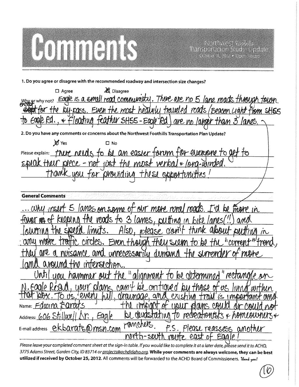
71
72
73

74
75
76
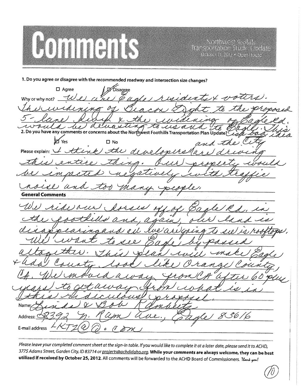
77
78
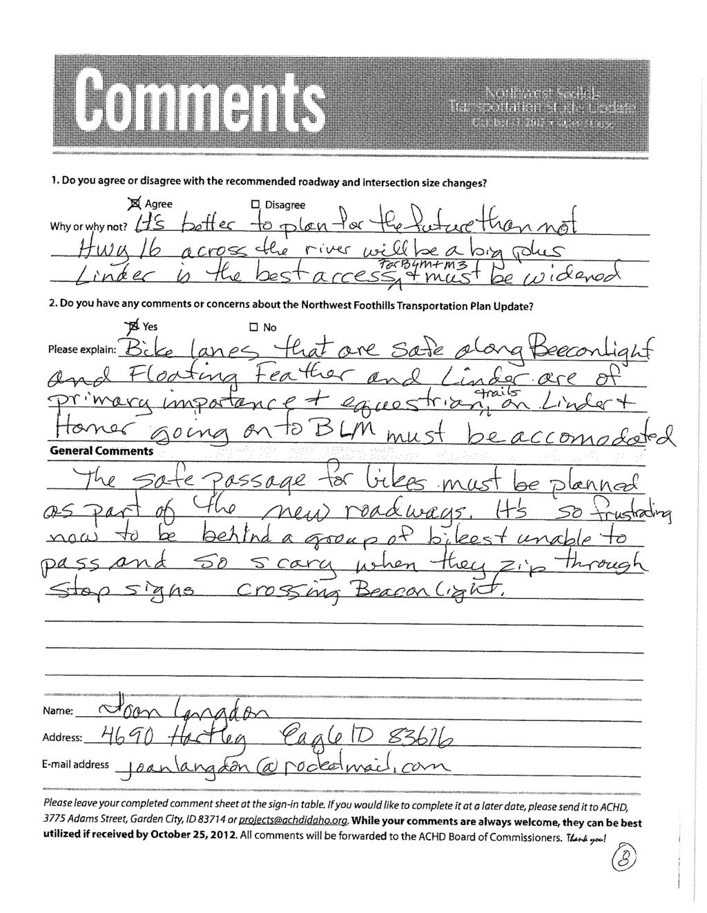
79
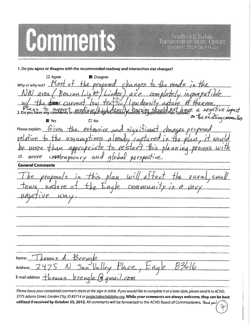
80
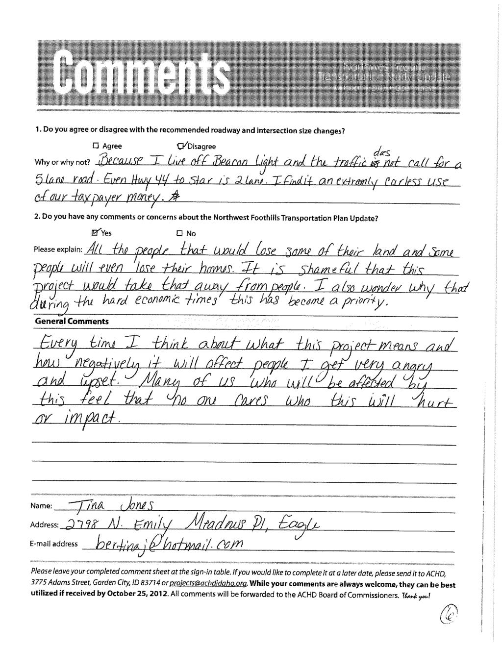
81
82
83
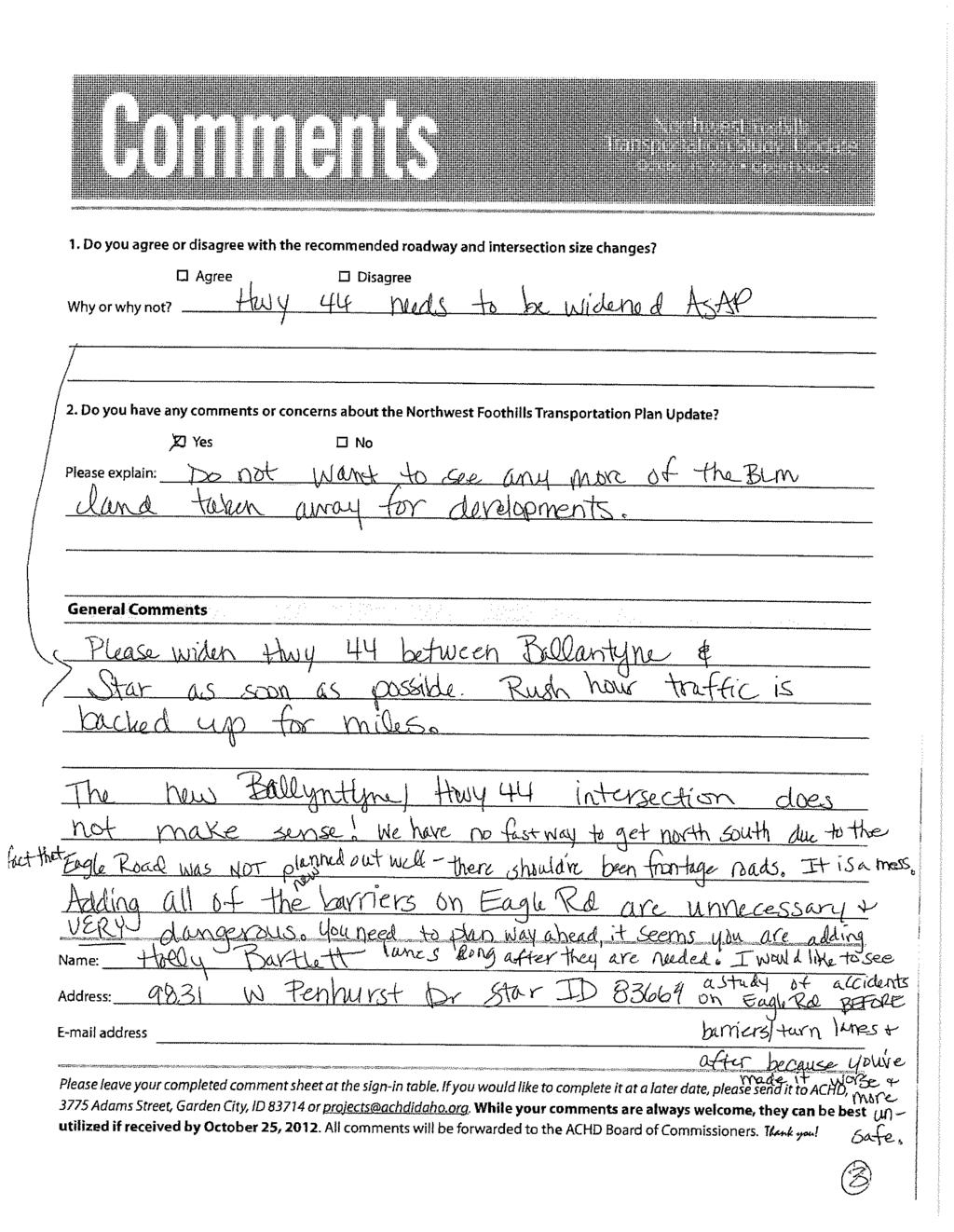
84
85
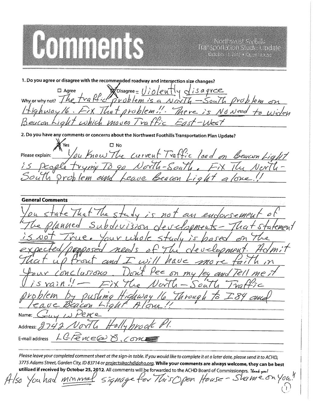
86
87
88
89 Appendix B Future Traffic Projections
90
91 - - Table B-1. Future Land-Use Estimates by Development Area.
92 Harmon 78 Suncor 792 M M3 Connolly «16 M Trailhead «32 HH, Jobs Kastera Alpine Creek Dry Creek DRY CREEK RD BEACON LIGHT RD CARTWRIGHT RD HWY 55 HWY FLOATING FEATHER RD LINDER RD EMMETT HWY EAGLE RD SEAMAN GULCH RD STATE ST Northwest Foothills Transportation Plan Update Sever this connection here Parks Schools AV-3 32 HH, 13 Jobs AV-2 4 HH, 3 Jobs M HH, 27 Jobs M HH, 348 Jobs H-1 13 HH, Jobs AV HH, Jobs M HH, Jobs AV-5 56 HH, Jobs AV-1 13 HH, 5 Jobs M HH, 592 Jobs M HH, 497 Jobs M HH, 28 Jobs TH-1 21 HH, Jobs C-1 53 HH, Jobs TV-1 58 HH, 3 Jobs H-1 3 HH, Jobs AC-1 38 HH, Jobs D HH, Jobs D HH, 5 Jobs D-3 65 HH, Jobs TAZ Previous Foothills Network NORTHWEST FOOTHILLS Figure LAND-USE UPDATES TAZ April 212 N H:\projfile\ NW Foothills Transportation Study Update\GIS\FutureLandUse_Revised.mxd Legend
93 US 2/ Brookside Brookside SH SH 55 Brookside Eagle Rd Beacon Light Rd. 1 1 Eagle Rd HorseshoeBendRd SH 55 5 Eagle Rd State St SH 44 (Bypass) Hill Rd SH Gillis Rd Duncan Gary Ln Eagle Rd Branstetter 1 US 2/ Licensed to Ada County Highway District Homer Rd Ballantyne Rd Beacon Light Rd 9 8 Ballantyne Rd Homer Rd 9 9 Park Ln Park Ln Park Ln. 98 SH SH Homer Rd Homer Rd Park Ln Park Ln Meridian Rd US 2/ Rd Linder Rd Linder Rd Linder Rd Linder Rd Linder Rd der Rd US 2/ Draft 212 Build: 212 Census Demographics on 212 Network 4/3/ SH SH Hartley Beacon Light Rd Pollard SH Star Rd SH Hartley Palmer 4 4 Pollard Beacon Light Rd. 1 1 Palmer Palmer 8 6 Plummer 7 7 Star Rd rd 6 7 SH SH 44 SH SH Plummer Star Rd Star Rd Joplin 2 2 Joplin 3 plin Black Cat Rd US 2/ US 2/ Joplin US 2/ McDermott Rd Black Cat Rd Star Rd ott Rd K:\FYWP \21\Base\b212\ROUNDED_b212.NET
94 Peak Hour (5pm to 6pm) 212 Build: 212 Demographics with 212 CIM Update Funded 4/4/212 Licensed to Ada County Highway District Peak Hour Existing Year:12 K:\FYWP \21\Base\b212\PH_ASSIGN_b212.NET SH SH SH Homer Rd Chaparral Rd Beacon Light Rd SH SH SH SH Park Ln Park Ln Beacon Light Rd SH Eagle Rd SH SH gle Rd Pierce Park Ln Cartwright Rd y Ln Hill Rd SH SH SH SH SH SH Brookside Hartley Linder Rd Star Rd SH SH Homer Rd Star Rd Can Ada Pollard Palmer Palmer Can Ada Can Ada Can Ada Star Rd Plummer rd Gambrell 3 3 Pollard 7 5 Hartley 1 Park Ln 5 2 Palmer Brookside SH
95 235 Build: 235 Refined Demographics with 231 CIP Network 7/19/212 Licensed to Ada County Highway District K:\NWFoothills\235\Base\Take 5\B235\ROUNDED_B235.NET SH SH Homer Rd Ballantyne Rd 3 3 Homer Rd Chaparral Rd Beacon Light Rd SH SH SH SH SH Linder Rd Floating Feather Rd Linder Rd Linder Rd Linder Rd Beacon Light Rd Park Ln Park Ln Park Ln Ballentyne Rd Beacon Light Rd Ballantyne Rd Floating Feather Rd SH Eagle Rd Beacon Light Rd Eagle Rd State St SH SH Eagle Rd SH Hill Rd Horseshoe Bend Rd Eagle Rd Dry Creek Rd Seaman's Gulch Rd Pierce Park Ln Star Rd Hill Rd Hill Rd SH SH SH 44 (Bypass) SH 44 (Bypass) SH 44 (Bypass) SH SH SH SH SH Palmer Hartley Linder Rd Eagle Rd Eagle Rd Linder Rd Floating Feather Rd SH Plummer SH SH Homer Rd 5 5 Homer Rd Park Ln tar Rd Floating Feather Rd Palmer Beacon Light Rd Eagle Rd Can Ada Can Ada Pollard Palmer Floating Feather Rd Palmer Can Ada Can Ada Can Ada Beacon Light Rd Beacon Light Rd Beacon Light Rd Beacon Light Rd Floating Feather Rd Star Rd SH SH Plummer rd 5 5 3rd 5 5 Gambrell Pollard Beacon Light Rd. Hartley Park Ln 32 3 Palmer Linder Rd Brookside Brookside Horseshoe Bend Rd SH Brookside SH
96 Peak Hour (5pm to 6pm) 235 Build: 235 Demographics with 231 CIP Update Funded 7/19/212 Licensed to Ada County Highway District NW Foothills Study-Initial Land-use K:\NWFoothills\235\Base\Take 5\B235\PH_ASSIGN_B235.NET SH SH Homer Rd Ballantyne Rd Homer Rd Chaparral Rd Beacon Light Rd SH SH SH SH SH Linder Rd Floating Feather Rd Linder Rd Linder Rd Linder Rd Beacon Light Rd Park Ln Park Ln Park Ln Ballentyne Rd Beacon Light Rd Ballantyne Rd Floating Feather Rd SH Eagle Rd Beacon Light Rd Eagle Rd State St SH SH Eagle Rd Star Rd US 2/ US 2/26 Black Cat Rd Meridian Rd SH Hill Rd Duncan Duncan Horseshoe Bend Rd Eagle Rd Eagle Rd Dry Creek Rd Seaman's Gulch Rd Pierce Park Ln Cartwright Rd Star Rd Gary Ln. Gary Ln State St Duncan SH Hill Rd Hill Rd Hill Rd Gary Ln Hill Rd Hill Rd Pierce P Castle Dr Bogart Ln SH SH Purple Sage Rd Blessinger Rd SH SH 44 (Bypass) SH 44 (Bypass) SH 44 (Bypass) SH SH SH SH SH SH Palmer Hartley Linder Rd Eagle Rd Eagle Rd Linder Rd Joplin Joplin Star Rd Rd Gillis Rd Caswell Floating Feather Rd SH SH Plummer SH SH Homer Rd Homer Rd Park Ln Star Rd Floating Feather Rd Palmer Beacon Light Rd Eagle Rd Can Ada Can Ada Alworth St Pollard Joplin Joplin Joplin Joplin Joplin Palmer Floating Feather Rd. 3 2 Palmer Can Ada Can Ada Can Ada Beacon Light Rd Beacon Light Rd Beacon Light Rd Beacon Light Rd Floating Feather Rd Star Rd SH SH Plummer rd rd Gambrell Pollard Beacon Light Rd. Hartley Park Ln Palmer Linder Rd Brookside Brookside Horseshoe Bend Rd Duncan SH Brookside Caswell SH Duncan Duncan Duncan SH
97 Peak Hour (5pm to 6pm) 235 Build: 235 Demographics with 231 CIP Update Funded 3/27/213 Licensed to Ada County Highway District NW Foothills Study-Initial Land-use K:\NWFoothills\235\Base\Take 7\B235\PH_ASSIGN_B235.NET SH Homer Rd Ballantyne Rd Homer Rd SH SH SH SH SH Linder Rd Linder Rd Linder Rd Park Ln Park Ln Park Ln Ballentyne Rd Beacon Light Rd Ballantyne Rd SH Eagle Rd Beacon Light Rd Eagle Rd State St Eagle Rd Star Rd US 2/26 Black Cat Rd US 2/ US 2/ US 2/ Linder Rd Meridian Rd US 2/ SH Duncan Duncan Horseshoe Bend Rd Eagle Rd Rd Star Rd McMillan Rd McDermott Rd McMillan Rd McMillan Rd Meridian Rd rmott Rd Grove Rd Black Cat Rd d Star Rd Edna St Marigold Duncan SH Hill Rd US 2/ Branstetter SH SH 44 (Bypass) SH SH Eagle Rd Hartley Linder Rd Eagle Rd Linder Rd Joplin Joplin Star Rd Star Rd SH McMillan Rd McMillan Rd McDermott Rd SH Plummer SH SH Homer Rd Homer Rd Park Ln Star Rd Palmer Eagle Rd Linder Rd Ten Mile Rd Pollard Joplin Joplin Joplin Palmer Palmer Linder Rd Beacon Light Rd Star Rd Plummer rd Gambrell Pollard Hartley Park Ln Palmer Brookside Horseshoe Bend Rd SH Brookside SH Duncan SH 16 6/7 :Lanes for Beacon Light Comparison
98 NWFTS 235 LINK VOLUME POST PROCESSING USING NCHRP 255 AND ANALYSIS 235 Post Processed AnlysVol 235Base Post Processed Street Location ExPMOld ExPMNew Ballantyne Lane n/o State Street Ballantyne Lane s/o Beacon Light Road Beacon Light Road w/o Ballantyne Lane Beacon Light Road e/o Ballantyne Lane Beacon Light Road w/o SH Beacon Light Road w/o Park Lane Beacon Light Road e/o Park Lane Beacon Light Road e/o Park Lane 3 Lane Beacon Light Road e/o Linder Road Beacon Light Road w/o Linder Road Beacon Light Road w/o Linder Road 3 Lane Beacon Light Road w/o Palmer Lane Beacon Light Road e/o Palmer Lane Beacon Light Road w/o SH Beacon Light Road e/o SH Beacon Light Road w/o Eagle Road Beacon Light Road e/o Eagle Road Beacon Light Road e/o Eagle Road 3lanes Eagle Road n/o Beacon Light Road Eagle Road s/o Beacon Light Road Eagle Road n/o Floating Feather Road Eagle Road s/o Floating Feather Road Eagle Road n/o State Street Eagle Road s/o State Street Eagle Road n/o SH Eagle Road s/o SH Floating Feather Road w/o SH Floating Feather Road e/o Ballantyne Lane Floating Feather Road e/o Park Lane Floating Feather Road w/o Park Lane Floating Feather Road e/o Linder Road Floating Feather Road w/o Linder Road Floating Feather Road e/o Palmer Lane Floating Feather Road e/o SH Floating Feather Road w/o SH Floating Feather Road w/o Eagle Road Floating Feather Road e/o Eagle Road Linder Road s/o Beacon Light Road Linder Road n/o Beacon Light Road Linder Road n/o Floating Feather Road Linder Road s/o Floating Feather Road Linder Road n/o SH Linder Road s/o SH Palmer Lane n/o Floating Feather Road
99 Palmer Lane s/o Floating Feather Road Palmer Lane s/o Beacon Light Road Palmer Lane n/o SH Park Lane n/o SH Park Lane s/o Floating Feather Road Park Lane n/o Floating Feather Road Park Lane s/o Beacon Light Road Park Lane n/o Beacon Light Road SH 16 n/o Beacon Light Road SH 16 s/o Chaparral Rd SH 16 s/o Beacon Light Road SH 16 n/o Floating Feather Road SH 16 s/o Floating Feather Road SH 16 n/o SH SH 16 s/o SH SH 44 w/o State Street SH 44 w/o Palmer Lane SH 44 w/o SH SH 44 e/o SH SH 44 w/o Linder Road SH 44 e/o Linder Road SH 44 w/o Eagle Road SH 44 e/o Eagle Road SH 44 w/o SH SH 44 e/o SH SH 55 n/o Hill Road SH 55 n/o SH SH 55 s/o Floating Feather Road SH 55 n/o Floating Feather Road SH 55 s/o Beacon Light Road SH 55 n/o Beacon Light Road SH 55 n/o Dry Creek Road SH 55 s/o Woods Gulch Road SH 55 n/o Woods Gulch Road SH 55 s/o Boise County Line State Street w/o Ballantyne Lane State Street e/o Ballantyne Lane State Street w/o Eagle Road State Street e/o Eagle Road NW Connection 1 e/o SH NW Connection 2 e/o SH Linder Road n/o Homer Road 1192 NE Connection 1 n/o Brookside Lane 172 NE Connection 2 w/o SH Brookside Lane w/o SH Brookside Lane e/o SH Spring Creek Lane e/o SH Dry Creek Road e/o SH Avimor East Road e/o SH 55 (south) 355
100 Avimor West Road w/o SH 55 (south) 451 Avimor West Road w/o SH 55 (north) 41 SH 16 n/o Chinden Boulevard Chinden Boulevard w/o SH Chinden Boulevard e/o SH Chinden Boulevard w/o Linder Road Chinden Boulevard e/o Linder Road Chinden Boulevard w/o Eagle Road Chinden Boulevard e/o Eagle Road
101 Appendix C Future Conditions Analysis
102
103 NWFTS 235 LINK VOLUME POST PROCESSING USING NCHRP 255 AND ANALYSIS Street Location 235 Post Processed AnlysVol LOS 235Base Post Processed NWTS Projection 235BPP_LOS Capacity Year Base Projection Capacity Year Ballantyne Lane n/o State Street 327 D 252 D Ballantyne Lane s/o Beacon Light Road 375 D 212 D Beacon Light Road w/o Ballantyne Lane 1394 D 1562 D Beacon Light Road e/o Ballantyne Lane 1285 D 1451 D Beacon Light Road w/o SH D 1326 D Beacon Light Road w/o Park Lane 1334 D 1537 D Beacon Light Road e/o Park Lane 1332 D 1499 D Beacon Light Road e/o Park Lane 3 Lane 1332 D 1499 D Beacon Light Road e/o Linder Road 1315 D 1515 D Beacon Light Road w/o Linder Road 1559 D 178 E Beacon Light Road w/o Linder Road 3 Lane 1559 D 178 E Beacon Light Road w/o Palmer Lane 1457 D 1513 D Beacon Light Road e/o Palmer Lane 143 D 1524 D Beacon Light Road w/o SH D 455 D Beacon Light Road e/o SH D 1562 D Beacon Light Road w/o Eagle Road 1285 D 146 D Beacon Light Road e/o Eagle Road 1259 D 1353 D Beacon Light Road e/o Eagle Road 3lanes 1259 D 1353 D Eagle Road n/o Beacon Light Road 41 D 551 E Eagle Road s/o Beacon Light Road 1133 F 716 F Eagle Road n/o Floating Feather Road 1168 F 783 F Eagle Road s/o Floating Feather Road 153 F 785 E Eagle Road n/o State Street 958 F 838 E Eagle Road s/o State Street 142 D 958 D Eagle Road n/o SH F 1431 D Eagle Road s/o SH F 218 F Floating Feather Road w/o SH D 57 D Floating Feather Road e/o Ballantyne Lane 97 F 79 F Floating Feather Road e/o Park Lane 58 E 522 D Floating Feather Road w/o Park Lane 548 D 498 D Floating Feather Road e/o Linder Road 464 D 419 D Floating Feather Road w/o Linder Road 534 D 598 E Floating Feather Road e/o Palmer Lane 325 D 374 D Floating Feather Road e/o SH D 266 D Floating Feather Road w/o SH D 338 D Floating Feather Road w/o Eagle Road 737 E 584 D Floating Feather Road e/o Eagle Road 727 E 643 D Linder Road s/o Beacon Light Road 99 D 698 D Linder Road n/o Beacon Light Road 1288 D 81 D Linder Road n/o Floating Feather Road 141 D 752 D Linder Road s/o Floating Feather Road 1545 D 1333 D Linder Road n/o SH D 1244 D Linder Road s/o SH F 233 F Palmer Lane n/o Floating Feather Road 36 D 286 D Palmer Lane s/o Floating Feather Road 39 D 336 D Palmer Lane s/o Beacon Light Road 266 D 26 D Palmer Lane n/o SH E 558 E Park Lane n/o SH E 476 D Park Lane s/o Floating Feather Road 538 D 441 D Park Lane n/o Floating Feather Road 388 D 211 D Park Lane s/o Beacon Light Road 366 D 187 D Park Lane n/o Beacon Light Road 158 D 31 D SH 16 n/o Beacon Light Road 2699 F 292 F SH 16 s/o Chaparral Rd 2142 F 1534 D SH 16 s/o Beacon Light Road 1966 F 963 D SH 16 n/o Floating Feather Road 1966 F 963 D
104 SH 16 s/o Floating Feather Road 214 F 179 D SH 16 n/o SH F 179 D SH 16 s/o SH F 275 F 222 #DIV/! SH 44 w/o State Street 2233 F 2288 F SH 44 w/o Palmer Lane 1948 F 279 F 2 21 SH 44 w/o SH F 1265 F SH 44 e/o SH F 2157 F SH 44 w/o Linder Road 2219 F 223 F SH 44 e/o Linder Road 224 F 2215 F SH 44 w/o Eagle Road 1563 D 1597 D SH 44 e/o Eagle Road 1591 D 1612 D SH 44 w/o SH F 222 F SH 44 e/o SH F 2366 F SH 55 n/o Hill Road 1859 D 1681 D SH 55 n/o SH D 1127 D SH 55 s/o Floating Feather Road 1676 D 151 D SH 55 n/o Floating Feather Road 245 F 1564 D SH 55 s/o Beacon Light Road 245 F 1564 D SH 55 n/o Beacon Light Road 1932 E 12 D SH 55 n/o Dry Creek Road 1596 D 983 D SH 55 s/o Woods Gulch Road 1537 D 912 D SH 55 n/o Woods Gulch Road 135 D 747 D SH 55 s/o Boise County Line 688 D 712 D State Street w/o Ballantyne Lane 264 D 2116 State Street e/o Ballantyne Lane 592 E 546 D State Street w/o Eagle Road 855 E 84 E State Street e/o Eagle Road 1154 F 965 F NW Connection 1 e/o SH D 194 D #DIV/! NW Connection 2 e/o SH D #DIV/! Linder Road n/o Homer Road 1192 D #DIV/! NE Connection 1 n/o Brookside Lane 172 D #DIV/! NE Connection 2 w/o SH D #DIV/! Brookside Lane w/o SH D 44 D #DIV/! Brookside Lane e/o SH D 18 D #DIV/! Spring Creek Lane e/o SH D 276 #NUM! Dry Creek Road e/o SH D 24 D Avimor East Road e/o SH 55 (south) 355 D 239 #NUM! Avimor West Road w/o SH 55 (south) 451 D #DIV/! Avimor West Road w/o SH 55 (north) 41 D #DIV/! SH 16 n/o Chinden Boulevard 229 F 275 F 222 #DIV/! Chinden Boulevard w/o SH F 1456 F Chinden Boulevard e/o SH F 255 F Chinden Boulevard w/o Linder Road 2122 F 2252 F Chinden Boulevard e/o Linder Road 2643 F 2569 F Chinden Boulevard w/o Eagle Road 2597 F 255 F Chinden Boulevard e/o Eagle Road 211 F 1975 F
105
106
107
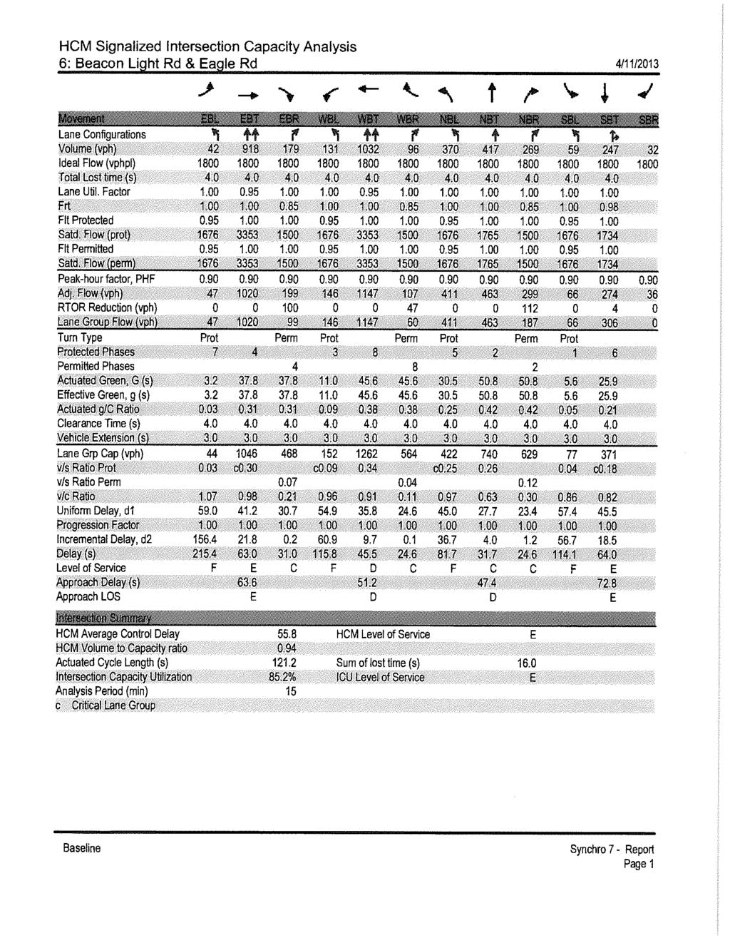
108
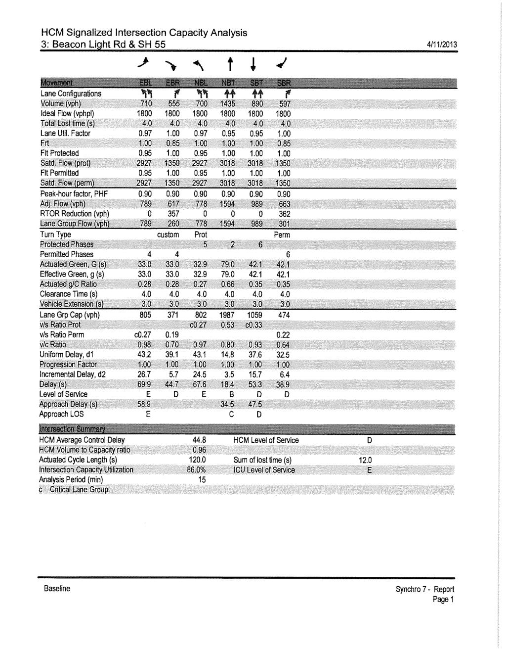
109
Northwest Foothills Transportation Study Update
 DRAFT Northwest Foothills Transportation Study Update Ada County, Idaho Study Area Parks Schools Prepared For Ada County Highway District 3775 Adams Street Garden City, Idaho 83714 (208) 387-6100 Prepared
ACHD COMMISSION DECISION
 DRAFT ACHD COMMISSION DECISION On January 22, 2014, the ACHD Commission voted to delay the decision on the adoption of this study until January 2015. The decision to the delay the adoption was a result
5.0 Roadway System Plan
 Southwest Boise Transportation Study Page 16 5.0 Roadway System Plan The Roadway System Plan outlines roadway improvements in the Initial Study Area. It forecasts future deficiencies on the arterial system,
State Highway 44/State Street High Capacity Corridor
 Background State Highway 44/State Street runs from I-84 in Canyon County through parts of the cities of Middleton, Star, Eagle, and Garden City to downtown Boise. It is a commuter route from several communities
Final Report. Southwest Boise Transportation Study. Prepared For: Ada County Highway District
 Final Report Southwest Boise Transportation Study Ada County, Idaho September 2009 Prepared by: 101 S Capitol Boulevard, Suite 301 Boise, ID 83702 (208) 338-2683 Southwest Boise Transportation Study Final
State Highway 16 Kuna-Mora Road to Ada/Gem County Line
 Background Update! (February 2018): This project has been partially funded; see below. State Highway 16 is the main commuter route from Gem County to the Treasure Valley. An increase in traffic and accidents
State Highway 16 Kuna-Mora Road to Ada/Gem County Line
 Background State Highway 16 is the main commuter route from Gem County to the Treasure Valley. An increase in traffic and accidents on this highway have been a concern for several years, and the Idaho
State Highway 16/McDermott Road Kuna-Mora Road to Ada/Gem County Line
 Background State Highway 16 is the main commuter route from Gem County to the Treasure Valley. An increase in traffic and accidents on this highway have been a concern for several years, and the Idaho
State Street Transit and Traffic Operational Plan June Æa «44 «55. Installation of Bus Bays. Land Use Activities
 State Street Transit and Traffic Operational Plan June 2011 FLOATING FEATHER RD $+ «16 PALMER LN Intersection Expansions SH 16 Extension Roadway Improvements èé Signalized Intersection $+ Intersection
MOUNTAIN HOUSE SPECIFIC PLAN I 9.1 INTRODUCTION ASSUMPTIONS TRANSPORTATION FACILITIES TRANSPORTATION IMPROVEMENTS PHASING 9.
 CHAPTER NINE: TRANSPORTATION AND CIRCULATION 9.1 INTRODUCTION 9.1 9.2 ASSUMPTIONS 9.1 9.3 TRANSPORTATION FACILITIES 9.1 9.4 TRANSPORTATION IMPROVEMENTS PHASING 9.3 LIST OF FIGURES LIST OF TABLES Figure
APPENDIX G: INTERSECTION NEEDS AT OKEECHOBEE BOULEVARD
 APPENDIX G: INTERSECTION NEEDS AT OKEECHOBEE BOULEVARD INTERSECTION NEEDS AT SR 7 and OKEECHOBEE BOULEVARD SR 7 Extension Project Development and Environment (PD&E) Study From Okeechobee Boulevard (SR
Basalt Creek Transportation Refinement Plan Recommendations
 Basalt Creek Transportation Refinement Plan Recommendations Introduction The Basalt Creek transportation planning effort analyzed future transportation conditions and evaluated alternative strategies for
What is the Congestion Management Process? What is Congestion? Growth in the Treasure Valley Development and Congestion
 Treasure Valley Annual Congestion Management System Report, 2017 07-2019 February 2019 Table of Contents Background and Introduction... 2 What is the Congestion Management Process?... 2 What is Congestion?...
State Street and Pierce Park Lane Intersection Concept Report
 State Street and Pierce Park Lane Intersection Prepared for September 2017 Prepared by CITATION Parametrix. 2017. State Street & Pierce Park Lane Intersection. Prepared by Parametrix, Boise, ID. September
WELCOME TO OPEN HOUSE # 1 June 14, 2017
 Langstaff Road Weston Road to Highway 7 Class Environmental Assessment Study WELCOME TO OPEN HOUSE # 1 June 14, 2017 Please sign in and join our mailing list Purpose of Open House #1 & Study Area York
Lee s Summit Road Improvement Study Public Open House June 7, 2007 Summary of Comment Card Responses
 Lee s Summit Road Improvement Study Public Open House June 7, 2007 Summary of Comment Card Responses Introduction At the Lee s Summit Road Improvement Study Public Open House held Thursday, June 7, 2007
3.0 Future Conditions
 3.0 Future Conditions In order to be able to recommend appropriate improvements to the transportation system of the Town, it is important to first understand the nature and volume of traffic that is expected
4. ENVIRONMENTAL IMPACT ANALYSIS 9. TRANSPORTATION AND TRAFFIC
 4. ENVIRONMENTAL IMPACT ANALYSIS 9. TRANSPORTATION AND TRAFFIC 4.9.1 INTRODUCTION The following section addresses the Proposed Project s impact on transportation and traffic based on the Traffic Study
Exhibit 1 PLANNING COMMISSION AGENDA ITEM
 Exhibit 1 PLANNING COMMISSION AGENDA ITEM Project Name: Grand Junction Circulation Plan Grand Junction Complete Streets Policy Applicant: City of Grand Junction Representative: David Thornton Address:
Review and Comment ACHD s FY Five Year Work Program Draft for Adoption
 Date: January 5, 2006 To: From: Mayor and City Council Karen Gallagher Planning and Development Services Meeting: January 10, 2006 Re: Review and Comment ACHD s FY 2007-2011Five Year Work Program Draft
City of Homewood Transportation Plan
 City of Homewood Transportation Plan Prepared for: City of Homewood, Alabama Prepared by: Skipper Consulting, Inc. May 2007 TABLE OF CONTENTS INTRODUCTION... 1 BACKGROUND INFORMATION... 1 EXISTING TRANSPORTATION
Highway 111 Corridor Study
 Highway 111 Corridor Study June, 2009 LINCOLN CO. HWY 111 CORRIDOR STUDY Draft Study Tea, South Dakota Prepared for City of Tea Sioux Falls Metropolitan Planning Organization Prepared by HDR Engineering,
Clackamas County Comprehensive Plan
 ROADWAYS The County s road system permits the movement of goods and people between communities and regions, using any of a variety of modes of travel. Roads provide access to virtually all property. They
WEST AND SOUTH WEST RING ROAD DOWNSTREAM TRAFFIC IMPACTS
 Page 1 of 9 EXECUTIVE SUMMARY Alberta Transportation ( AT ) is preparing to construct the final sections of the Calgary Ring Road. This includes the South West Ring Road ( SWRR ) (from Lott Creek Blvd
CHIEF PEGUIS TRAIL EXTENSION WEST
 1 PRELIMINARY DESIGN OF THE CHIEF PEGUIS TRAIL EXTENSION WEST Public Information Session June 6, 2017 Welcome 1 Thank you for attending today s public information session. The following boards provide
Traffic Study 30th Street Specific Area Plan
 Prepared for HDR Engineering, Inc. River Quarry at Park Center 412 E. Parkcenter Blvd., Suite 100 Boise, ID 83706-6659 Prepared by 5561 N Glenwood Street, Suite B Boise, ID 83714-1336 208-898-0012 www.parametrix.com
Committed to Service
 Development Services Department Committed to Service TO: FROM: Ada County Highway District Commissioners Mindy Wallace, AICP Planner III COMISSION HEARING: January 27, 2016 SUBJECT: Syringa Valley Specific
Chapter 4 Traffic Analysis
 Chapter 4 Traffic Analysis PURPOSE The traffic analysis component of the K-68 Corridor Management Plan incorporates information on the existing transportation network, such as traffic volumes and intersection
JONESBORO HIGHWAY 63 HIGHWAY 18 CONNECTOR STUDY
 JONESBORO HIGHWAY 63 HIGHWAY 18 CONNECTOR STUDY Craighead County May 2007 JONESBORO HIGHWAY 63 HIGHWAY 18 CONNECTOR STUDY Craighead County May 2007 Prepared by Planning and Research Division Arkansas State
Peer Review of Highlands Neighborhood Traffic and Pedestrian Safety Plan
 FINAL REPORT March 14, 2017 Prepared for: Ada County Highway District Prepared by: SIX MILE ENGINEERING, PA Executive Summary The (Highlands Safety Plan) developed by the Ada County Highway District (ACHD)
Los Altos Hills Town Council - June 18, 2015 Palo Alto City Council June 22, AGENDA ITEM #2.B Presentation
 Los Altos Hills Town Council - June 18, 2015 Palo Alto City Council June 22, 2015 AGENDA ITEM #2.B Presentation Previous Presentations Los Altos Hills Town Council in May 2014 and February 2015 Palo Alto
Transportation Master Plan Advisory Task Force
 Transportation Master Plan Advisory Task Force Network Alternatives & Phasing Strategy February 2016 BACKGROUND Table of Contents BACKGROUND Purpose & Introduction 2 Linking the TMP to Key Council Approved
Welcome. The Brooklin Secondary Plan and Transportation Master Plan are collectively referred to as the Brooklin Study.
 Welcome The Town of Whitby is undertaking a study to prepare a Secondary Plan and Transportation Master Plan to guide and manage growth in the Brooklin area. The Brooklin Secondary Plan and Transportation
City of Wayzata Comprehensive Plan 2030 Transportation Chapter: Appendix A
 A1. Functional Classification Table A-1 illustrates the Metropolitan Council s detailed criteria established for the functional classification of roadways within the Twin Cities Metropolitan Area. Table
Circulation in Elk Grove includes: Motor vehicles, including cars and trucks
 Circulation, as it is used in this General Plan, refers to the many ways people and goods move from place to place in Elk Grove and the region. Circulation in Elk Grove includes: Motor vehicles, including
Sixth Line Development - Transit Facilities Plan
 Memorandum Date: November 13, 2012 To: From: c.c. Subject: Rob Freeman (Freeman Planning) Kevin Phillips Sixth Line Development - Transit Facilities Plan 33016631 This memo was prepared to review the transit
ACHD Commission, Director, and Deputy Directors
 John S. Franden, President Mitchell A. Jaurena, Vice President Rebecca W. Arnold, Commissioner Sara M. Baker, Commissioner Jim D. Hansen, Commissioner March 19, 2014 TO: FROM: SUBJECT: ACHD Commission,
Project Update May 2018
 Project Update May 2018 Dakota County, in cooperation with the City of Lakeville, is planning to reconstruct 202 nd Street West (County Road 50) from Holyoke Avenue to Cedar Avenue (County Road 23). 202
Access Management Regulations and Standards
 Access Management Regulations and Standards January 2014 Efficient highway operation Reasonable property access Concept of Access Management The way to manage access to land development while preserving
Committed to Service
 Development Services Department Committed to Service January 19, 2016 TO: FROM: SUBJECT: ACHD Board of Commissioners Mindy Wallace, AICP Planner III Kirsten Subdivision/BPP15-0023 Executive Summary: The
DUNBOW ROAD FUNCTIONAL PLANNING
 DUNBOW ROAD FUNCTIONAL PLANNING Final Report August 3, 216 #31, 316 5th Avenue NE Calgary, AB T2A 6K4 Phone: 43.273.91 Fax: 43.273.344 wattconsultinggroup.com Dunbow Road Functional Planning Final Report
Develop a Multi-Modal Transportation Strategy (Theme 6)
") DEVELOP A MULTI-MODAL TRANSPORTATION STRATEGY (THEME 6) WHY IS THIS THEME ADDRESSED? Develop a Multi-Modal Transportation Strategy (Theme 6) Statement of Ideal Reduce resident and visitor reliance on single
DEVELOP A MULTI-MODAL TRANSPORTATION STRATEGY (THEME 6) WHY IS THIS THEME ADDRESSED? Develop a Multi-Modal Transportation Strategy (Theme 6) Statement of Ideal Reduce resident and visitor reliance on single
Table 1: Recommended Interim Improvement and Long Term Improvement/ROW Preservation Proposed Improvements. Recommended Interim Improvement
 Rebecca W. Arnold, President Sara M. Baker, Vice President John S. Franden, Commissioner Carol A. McKee, Commissioner Mitchell Jaurena, Commissioner June 19, 2012 Planning & Programming Department TO:
Town of Bethlehem. Planning Assessment. Bethlehem Town Board
 Town of Bethlehem US 9W Corridor Transportation Planning Assessment Presented e to: Bethlehem Town Board June 2009 Overview Study Background Route 9W Corridor Conditions and Improvements Selkirk Bypass
EXECUTIVE SUMMARY OF CALEDON TRANSPORTATION NEEDS STUDY
 EXECUTIVE SUMMARY OF CALEDON TRANSPORTATION NEEDS STUDY The Caledon Transportation Needs Study has been undertaken as a joint project by the Town of Caledon and the Region of Peel to determine the existing
TRAFFIC STUDY GUIDELINES Clarksville Street Department
 TRAFFIC STUDY GUIDELINES Clarksville Street Department 9/1/2009 Introduction Traffic studies are used to help the city determine potential impacts to the operation of the surrounding roadway network. Two
Access Management Regulations and Standards
 Access Management Regulations and Standards Efficient highway operation Reasonable property access Concept of Access Management The way to manage access to land development while simultaneously preserving
BETHEL ROAD AND SEDGWICK ROAD CORRIDOR STUDY
 DRAFT PLAN City Council Meeting August 14, 2017 STUDY AREA Sedgwick Corridor State Route 160, principal arterial with Class 3 access management designation, commuter and freight route, connection to SR
TRANSPORTATION NEEDS ASSESSMENT
 TRANSPORTATION NEEDS ASSESSMENT A travel demand analysis was carried out to determine the operational issues and the potential benefit that adding traffic capacity would have on the road network. All the
Operational Comparison of Transit Signal Priority Strategies
 Operational Comparison of Transit Signal Priority Strategies Revision Submitted on: November, 0 Author: Adriana Rodriguez, E.I Assistant Engineer Parsons Brinckerhoff 0 South Orange Avenue, Suite 00 Orlando,
Broad Street Bicycle Boulevard City Council Study Session Summary
 Broad Street Bicycle Boulevard City Council Study Session Summary Overview: On August 15 th, 2017, a City Council Study Session was held to invite community input and request City Council guidance on a
ADOT Statewide Bicycle and Pedestrian Program Summary of Phase IV Activities APPENDIX B PEDESTRIAN DEMAND INDEX
 ADOT Statewide Bicycle and Pedestrian Program Summary of Activities APPENDIX B PEDESTRIAN DEMAND INDEX May 24, 2009 Pedestrian Demand Index for State Highway Facilities Revised: May 29, 2007 Introduction
ARTINSVILLE ENRY OUNTY REA RANSPORTATION TUDY
 ARTINSVILLE ENRY OUNTY REA RANSPORTATION TUDY DEVELOPED BY THE TRANSPORTATION AND MOBILITY PLANNING DIVISION OF THE VIRGINIA DEPARTMENT OF TRANSPORTATION IN COOPERATION WITH THE U.S. DEPARTMENT OF TRANSPORTATION,
TRAFFIC ACTION PLAN. North Central Neighborhood CITY OF SAN MATEO
 TRAFFIC ACTION PLAN North Central Neighborhood CITY OF SAN MATEO Draft February 2017 Table of Contents Introduction... 1 The Traffic Forum Process... 4 Neighborhood Traffic Issues... 6 Neighborhood Recommendations
Executive Summary Route 30 Corridor Master Plan
 Route Corridor Master Plan Project Overview The Route Corridor Master Plan is a coordinated multimodal transportation and land use plan for the entire stretch of Route through East Whiteland Township,
Highway 217 Corridor Study. Phase I Overview Report
 Highway 217 Corridor Study Phase I Overview Report November 3, 24 BACKGROUND AND OVERVIEW Study purpose The Highway 217 Corridor Study is developing multi-modal transportation solutions for traffic problems
Report Purpose To seek Council s approval of the Wye Road Functional Planning Study (January 2015).
.") COUNCIL MEETING Meeting Date: March 10, 2015 Agenda Item #: 13.1 Wye Road Functional Planning Study (January 2015) Report Purpose To seek Council s approval of the Wye Road Functional Planning Study (January
COUNCIL MEETING Meeting Date: March 10, 2015 Agenda Item #: 13.1 Wye Road Functional Planning Study (January 2015) Report Purpose To seek Council s approval of the Wye Road Functional Planning Study (January
West Dimond Blvd Upgrade Jodhpur Street to Sand Lake Road
 West Dimond Blvd Jodhpur St to Sand Lake CSS Transportation Project Summary Municipality of Anchorage Project # 05 005 Project Manager: John Smith, P.E. (MOA PM&E) Project Administrator: Julie Makela,
12 RECOMMENDATIONS Road Improvements. Short Term (generally the next five years)
") 12 RECOMMENDATIONS Recommendations are based on the technical analysis of existing and future road and active transportation conditions, the results of the review of existing City policies and public feedback.
12 RECOMMENDATIONS Recommendations are based on the technical analysis of existing and future road and active transportation conditions, the results of the review of existing City policies and public feedback.
SANTA MONICA BOULEVARD CORRIDOR
 CIRCULATION ELEMENT WHITE PAPER NO. 3 SANTA MONICA BOULEVARD CORRIDOR INTRODUCTION From the 1930s to the beginning of Los Angeles freeway era, Santa Monica Boulevard, (previously Route 66, the Beverly
APPENDIX 2 LAKESHORE ROAD TRANSPORTATION REVIEW STUDY EXECUTIVE SUMMARY
 APPENDIX 2 LAKESHORE ROAD TRANSPORTATION REVIEW STUDY EXECUTIVE SUMMARY Appendix 2 City of Mississauga Lakeshore Road FINAL REPORT Transportation Review Study December 2010 EXECUTIVE SUMMARY Study Purpose
IMPLEMENTATION STRATEGIES
 GEORGETOWN SIDEWALK MASTER PLAN 34% of funding is dedicated to Downtown Overlay District sidewalks 28% of funding is recommended within 1/4 mile of Southwestern University 26% of funding is recommended
FY Regional Transportation Improvement Program
 FY2014-2018 Regional Transportation Improvement Program Basic Project List (All Values in Thousands of Dollars) All costs in current dollars Project Name Key # Year Project Cost 10th Avenue Bridge, Caldwell
CHAPTER 4: IDENTIFICATION OF ROAD SYSTEM DEFICIENCIES: TRANSPORTATION PLANNING MODEL
 CHAPTER 4: IDENTIFICATION OF ROAD SYSTEM DEFICIENCIES: TRANSPORTATION PLANNING MODEL I. INTRODUCTION Transportation planning models are the primary tools used to predict future travel conditions. With
LSC TRANSPORTATION CONSULTANTS, INC. 516 North Tejon Street Colorado Springs, CO (719) FAX (719)
 FAX (719)") LSC TRANSPORTATION CONSULTANTS, INC. 516 North Tejon Street Colorado Springs, CO 80903 (719) 633-2868 FAX (719) 633-5430 E-mail: lsc@lsccs.com May 15, 2009 Mr. Davis Farrar Western Slope Consulting, LLC
LSC TRANSPORTATION CONSULTANTS, INC. 516 North Tejon Street Colorado Springs, CO 80903 (719) 633-2868 FAX (719) 633-5430 E-mail: lsc@lsccs.com May 15, 2009 Mr. Davis Farrar Western Slope Consulting, LLC
David DiPierro, John Amberson. Steering Committee Meeting #4 Overview
 IBI GROUP 18401 Von Karman Avenue Suite 110 Irvine CA 92612 USA tel 949 833 5588 fax 949 833 5511 ibigroup.com Memorandum To/Attention Steering Committee Members Date February 17, 2016 From IBI Group Project
LOOP 360 IMPROVEMENT STUDY
 LOOP 360 IMPROVEMENT STUDY Overview and Preliminary Analysis August 2015 1 STUDY PROCESS 2 Study Background Loop 360 serves a wide range of users, including residents, businesses, bicyclists, and commuters
Owl Canyon Corridor Project Overview and Summary
 Owl Canyon Corridor Project Overview and Summary December 22, 2008 The Owl Canyon corridor (generally the connection between the I-25 / Larimer County Road 70 interchange and the US 287 / Larimer County
Executive Summary June 2015
 Executive Summary June 2015 Highway 112 Corridor Study Benton and Washington Counties Executive Summary June 2015 Prepared by Transportation Planning and Policy Division Arkansas State Highway and Transportation
EAGLE ROAD AND STATE STREET INTERSECTION CONCEPT STUDY
 EAGLE ROAD AND STATE STREET INTERSECTION CONCEPT STUDY Eagle, Idaho May 2014 This page intentionally left blank Eagle, Idaho Prepared For: Ada County Highway District (ACHD) 3775 Adams St. Garden City,
TRAFFIC IMPACT STUDY COMPREHENSIVE UPDATE TOWN OF THOMPSON S STATION, TENNESSEE PREPARED FOR: THE TOWN OF THOMPSON S STATION
 TRAFFIC IMPACT STUDY COMPREHENSIVE UPDATE TOWN OF THOMPSON S STATION, TENNESSEE PREPARED FOR: THE TOWN OF THOMPSON S STATION Transportation Consultants, LLC 1101 17 TH AVENUE SOUTH NASHVILLE, TN 37212
Southwest Bus Rapid Transit (SW BRT) Functional Planning Study - Executive Summary January 19 LPT ATTACHMENT 2.
 Functional Planning Study - Executive Summary January 19 LPT ATTACHMENT 2.") Southwest Bus Rapid Transit (SW BRT) Functional Planning Study - Executive Summary 2011 January 19 1 of 19 Introduction This executive summary presents the results of the Southwest Bus Rapid Transit (SW
Southwest Bus Rapid Transit (SW BRT) Functional Planning Study - Executive Summary 2011 January 19 1 of 19 Introduction This executive summary presents the results of the Southwest Bus Rapid Transit (SW
Committed to Service
 Committed to Service Paul Woods, President Rebecca W. Arnold, Vice President Sara M. Baker, Commissioner Jim D. Hansen, Commissioner Kent Goldthorpe, Commissioner March 14, 2017 Planning and Programming
TRANSPORTATION ANALYSIS REPORT US Route 6 Huron, Erie County, Ohio
 TRANSPORTATION ANALYSIS REPORT US Route 6 Huron, Erie County, Ohio December 12, 2012 Prepared for: The City of Huron 417 Main Huron, OH 44839 Providing Practical Experience Technical Excellence and Client
City of Gainesville Transportation/Roadway Needs PROJECT SUMMARY
 A1 Roadway Resurfacing $23,846,000 TYPE: Preservation of existing system Roadway resurfacing A2 Signal Replacement $6,000,000 TYPE: Preservation of existing system Replace traffic signals. B1 W 6th St
Employment 8,881 17,975 9,094. Households 18,990 31,936 12,946
 This section describes the future transportation environment of the UW Tacoma campus and surrounding area. A description of the future conditions on campus in terms of the street system, traffic and intersection
CITY OF ALPHARETTA DOWNTOWN MASTER PLAN TRAFFIC EVALUATION
 CITY OF ALPHARETTA DOWNTOWN MASTER PLAN TRAFFIC EVALUATION June 2015 CITY OF ALPHARETTA DOWNTOWN MASTER PLAN TRAFFIC EVALUATION Introduction The Alpharetta Downtown Master Plan was developed in the fall
Anholm Bikeway Plan Planning Commission Meeting Summary (8/14/18)
") Anholm Bikeway Plan Planning Commission Meeting Summary (8/14/18) Overview: On August 14, 2018, the Planning Commission considered plans for the middle section of the Anholm Bikeway Plan, focusing on the
Anholm Bikeway Plan Planning Commission Meeting Summary (8/14/18) Overview: On August 14, 2018, the Planning Commission considered plans for the middle section of the Anholm Bikeway Plan, focusing on the
CITY OF COCOA BEACH 2025 COMPREHENSIVE PLAN. Section VIII Mobility Element Goals, Objectives, and Policies
 CITY OF COCOA BEACH 2025 COMPREHENSIVE PLAN Section VIII Mobility Element Goals, Objectives, and Policies Adopted August 6, 2015 by Ordinance No. 1591 VIII MOBILITY ELEMENT Table of Contents Page Number
PRELIMINARY DRAFT FIRST AMENDMENT TO VISION 2050: A REGIONAL LAND USE AND TRANSPORTATION PLAN FOR SOUTHEASTERN WISCONSIN
 PRELIMINARY DRAFT FIRST AMENDMENT TO VISION 2050: A REGIONAL LAND USE AND TRANSPORTATION PLAN FOR SOUTHEASTERN WISCONSIN ESTABLISHING TARGETS FOR FEDERAL PERFORMANCE MEASURES: HIGHWAY SAFETY SOUTHEASTERN
CIRCLE DRIVE TRAFFIC AND ACCESS MANAGEMENT POLICY GUIDE. Management Principles and Implementation Concepts
 CIRCLE DRIVE TRAFFIC AND ACCESS MANAGEMENT POLICY GUIDE A. PREFACE Management Principles and Implementation Concepts The intent of this policy guide is to provide interim guidance on the implementation
AGENDA REPORT. Issue: Discussion of potential improvements on Barnwell Road at Niblick Drive
 AGENDA REPORT To: From: By: Honorable Mayor and City Council Members Warren Hutmacher, City Manager Tom Black, Public Works Director Date: March 23, 2016 Agenda: March 28, 2016 WORK SESSION AGENDA: Barnwell
ARLINGTON COUNTY, VIRGINIA
 ARLINGTON COUNTY, VIRGINIA County Board Agenda Item Meeting of October 15, 2016 DATE: October 7, 2016 SUBJECT: Adoption of amendments to the Master Transportation Plan (MTP) to create a new Pedestrian
RZC Appendix 8A Marymoor Subarea Street Requirements
 RZC Appendix 8A Marymoor Subarea Street Requirements For additional design details for Marymoor Subarea infrastructure, refer to the 2017 Marymoor Subarea Infrastructure Planning Report. STREET REQUIREMENTS
3.0 PROJECT DESCRIPTION
 The following section of the Draft EIR contains a description of the proposed Elk Grove Boulevard/SR 99 Interchange Modification project, consistent with the requirements of CEQA Guidelines Section 15124.
Living Streets Policy
 Living Streets Policy Introduction Living streets balance the needs of motorists, bicyclists, pedestrians and transit riders in ways that promote safety and convenience, enhance community identity, create
Moving Cambridge. City of Cambridge Transportation Master Plan Public Consultation Centre. March 7, :00 8:00 PM.
 City of Cambridge Transportation Master Plan Public Consultation Centre March 7, 2018 5:00 8:00 PM Region of Waterloo City of Cambridge Transportation Master Plan Public Consultation Centre March 7, 2018
University Hill Transportation Study Technical Memorandum Alternatives Modeling and Analysis May 2007
 Technical Memorandum May 2007 Syracuse Metropolitan Transportation Council Edwards and Kelcey with Wallace Roberts and Todd Alta Planning and Design CONTENTS SECTION ONE- INTRODUCTION...1 SECTION TWO-
CITY OF BLOOMINGTON COMPLETE STREETS POLICY
 CITY OF BLOOMINGTON COMPLETE STREETS POLICY POLICY OBJECTIVE: The City of Bloomington will enhance safety, mobility, accessibility and convenience for transportation network users of all ages and abilities,
#!! "$% ##! &! # '#! % $ #!
 Executive Summary US Highway 16 (US 16) is the primary corridor connecting Rapid City to the Black Hills region. It serves a growing population of commercial and residential traffic, as well as seasonal
Chapter 6 Transportation Plan
 Chapter 6 Transportation Plan Transportation Plan Introduction Chapter 6 Transportation Plan Transportation Plan Introduction This chapter describes the components of Arvada s transportation system, comprised
METHODOLOGY. Signalized Intersection Average Control Delay (sec/veh)
") Chapter 5 Traffic Analysis 5.1 SUMMARY US /West 6 th Street assumes a unique role in the Lawrence Douglas County transportation system. This principal arterial street currently conveys commuter traffic
Chapter 5 Traffic Analysis 5.1 SUMMARY US /West 6 th Street assumes a unique role in the Lawrence Douglas County transportation system. This principal arterial street currently conveys commuter traffic
South King County High-Capacity Transit Corridor Study
 HIGH-CAPACITY TRANSIT CORRIDOR STUDY South King County Corridor South King County High-Capacity Transit Corridor Study Corridor Report August 2014 South King County High Capacity Transit Corridor Report
Northwest Boise NEIGHBORHOOD WALKING AND BIKING PLAN
 Northwest Boise NEIGHBORHOOD WALKING AND BIKING PLAN OCTOBER 2015 This page is intentionally left blank. Northwest Boise NEIGHBORHOOD WALKING AND BIKING PLAN The Northwest Boise Neighborhood Walking and
Route 7 Corridor Study
 Route 7 Corridor Study Executive Summary Study Area The following report analyzes a segment of the Virginia State Route 7 corridor. The corridor study area, spanning over 5 miles in length, is a multi
Chapter 3 BUS IMPROVEMENT CONCEPTS
 Chapter 3 BUS IMPROVEMENT CONCEPTS The purpose of this chapter is to describe potential bus improvement strategies and potential impacts or implications associated with BRT implementation within the existing
TRANSPORTATION & MOBILITY
 TRANSPORTATION & MOBILITY ROADWAY SYSTEM There are approximately 40 miles of roadways in Manitou Springs. For planning purposes, roadways are typically assigned a functional classification which defines
Third Street Bridge & Corridor Project
 Third Street Bridge & Corridor Project Preparation for the FY2018 budget to commence October 1, 2017, includes funding to address a project that has been considered since 1994. The Third Street bridge
Committed to Service. Development Services. February 21, ACHD Commission. Mindy Wallace, AICP
 Committed to Service Sara M. Baker, President Rebecca W. Arnold, Vice President Jim D. Hansen, Commissioner Kent Goldthorpe, Commissioner Paul Woods, Commissioner February 21, 2018 Development Services
City of Elizabeth City Neighborhood Traffic Calming Policy and Guidelines
 City of Elizabeth City Neighborhood Traffic Calming Policy and Guidelines I. Purpose: The City of Elizabeth City is committed to ensure the overall safety and livability of residential neighborhoods. One