SAFETY ANALYSIS OF DRIVEWAY CHARACTERISTICS IN SOUTH CAROLINA USING GIS. Wayne A. Sarasua Kweku Brown
|
|
|
- Iris Richards
- 5 years ago
- Views:
Transcription


1 SAFETY ANALYSIS OF DRIVEWAY CHARACTERISTICS IN SOUTH CAROLINA USING GIS Wayne A. Sarasua Kweku Brown

2 Overall Goal The overall goal of this project is to enhance SCDOT s current access management practices resulting in a reduction in crashes, injuries, and fatalities on South Carolina roadways as well as improved traffic flow

3 Literature Review Access Management studies generally fall into three categories : Impacts on Safety Median Access point density Sight distance Intersection & Interchange Turn prohibition Impacts on Traffic Operations Level of service Capacity Impacts on Residents and Business
4 Literature Review Access point density: Schultz et al., Safety impacts of access management techniques in Utah, (2007) evaluated the safety performance of arterials in which access management techniques have been implemented. They concluded that the relationship between access points per mile and crash rate has a positive correlation in Utah. Frawley and Eisele, Crash analyses of raised medians and driveway density: How access management makes communities safer, (2004) completed an evaluation of 11 case studies in Texas and Oklahoma and showed that implementing raised medians and performing driveway consolidation would reduce the potential number of conflicts points along roadways. Conclusion: reducing access point density reduces crash rates, reduces speed differential between vehicles, enhances operation and could improve roadway capacity and reduce need of new capacity improvement
5 Literature Review Medians: Gattis et al., Roadway median treatments, (2010) examined relationships among crash rates and different types of median (None with occasional left turn lanes, two-way left-turn lane, Raised, Depressed) of roadways in Arkansas. They concluded that raised or depressed median yield the lowest crash rates. Mauga and Kaseko (2010) evaluated and quantified the impact of types of medians, including raised medians and two-way-left-turn-lanes on traffic safety in the midblock sections. The results showed that segments with a raised median had lowered the crash rate by 23% compared to segments with a TWLTL. Schultz et al., Safety benefits of median installations in Utah, (2012) analyzed safety at locations where raised medians are installed. They concluded that raised medians significantly reduce crash frequency and severity. Frawley, Raised median economic impact and safety research findings: Application for Cooper street, (2010) studied the benefit of converting a two-way left turn lane to a raised median for particular locations in Bryan, Temple and Tyler, Texas. The benefits include lower crash frequency, fewer crashes involving left-turns, no migration of crashes to intersections, very few U-turn crashes, and fewer severe crashes. Conclusion: Raised medians reduce crash frequency and severity with no migration of crashes to intersections. Traffic operations are improved.
6 A Methodology for Determining the Economic Impacts of Raised Medians William L. Eisele, P.E., and William E. Frawley, AICP (TTI 1999) Business owners who were present before, during, and after the median installation felt that their regular customers continued to use their businesses In contrast, those businesses that were interviewed prior to the installation of the raised median thought their customers would be less likely to continue to use their businesses Perceptions appear worse than reality

7 Data Collection Procedures and Data Summary

8 30 Preliminary Corridors

9 SC Geocoded Crashes
 and 2012")
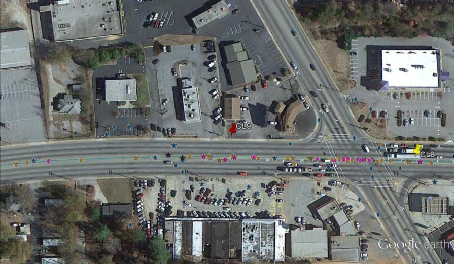
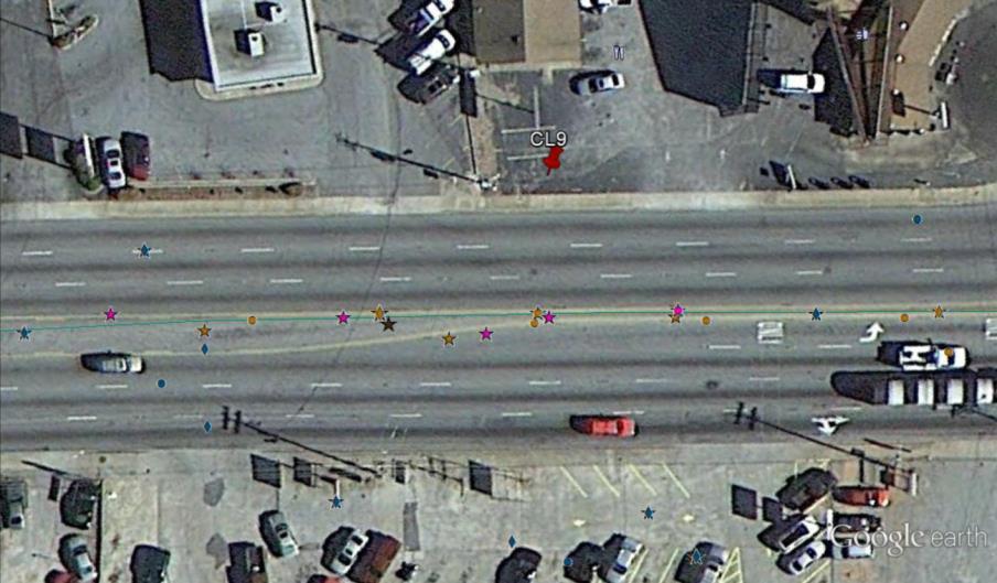
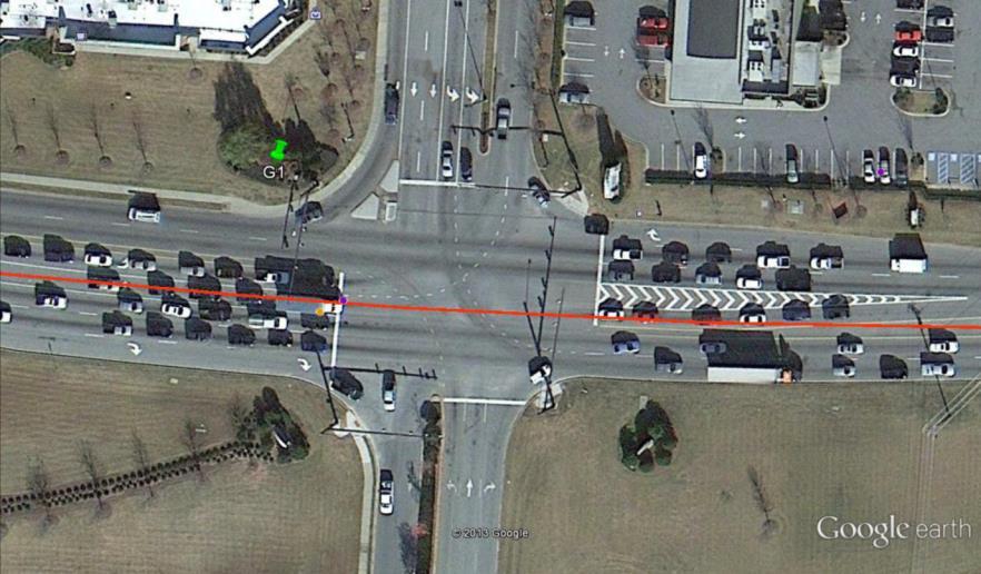
10 Rear-end and angle crashes on US 25 in Greenville, SC for 2010 (left) and 2012 (right)
11 Symbol Table Driveway Related Crash Angle Crash Rear-end Crash
12 Greenville US 25 Length - 66 Driveway Crashes Rank 2 Rear End Angle 693 Clusters 9
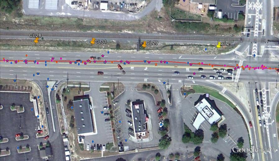
13 Greenville US 25
14 Greenville SC 146 Length 13.9 Driveway Crashes Rank 3 Rear End 676 Angle 373 Clusters 20

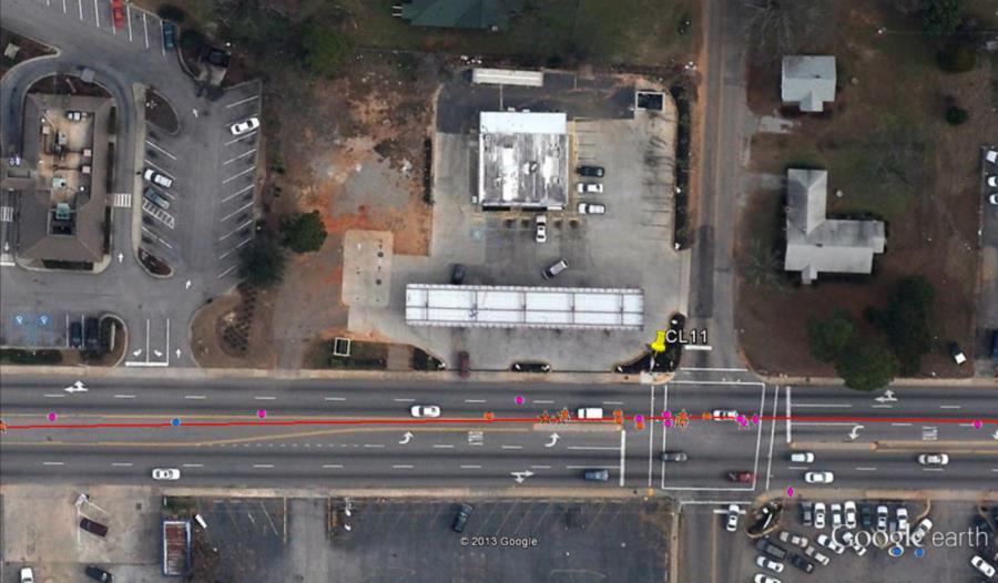
15 Greenville SC 146
16 Greenville SC 146

17 Greenwood US 25
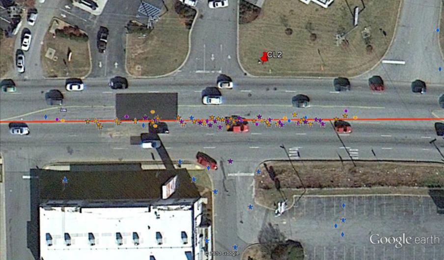
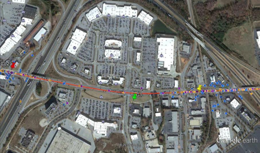
18 Richland US 1 Length 22.0 Driveway Crashes Rank 1 Rear End 1270 Angle Clusters - 30

19 Richland US 1
20
21
22 Before and After Results

23 Richland US 176
24 Final 11 Corridors COUNTY ROUTE TYPE ROUTE NUMBER LENGTH (MILES) 3 YEAR DRIVEWAY AVG RANK DRIVEWAY CRASHES Richland US Greenville US Greenville SC Richland US Lexington US Horry US Spartanburg SC Greenville US York US Berkeley US Florence US
25 Map of 11 Corridors
26 Corridor Analysis Data Collection Process Geometric Data were collected for selected corridors in three categories Segment -intersection to intersection Driveway Intersection All data were geocoded into ArcGIS

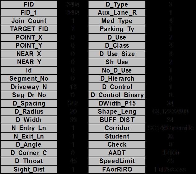
27 Sample Driveway with Attributes
28 Driveway Spacing

29 Skew Angles
30 Safety Analysis
31 Right In Right Out Buffers

32 Full Access Buffers
33 Proximity Analysis Average Distance from Reported Route by Year Average Distance (FT) Route US 1, Richland US 25, Greenville SC 146, Greenville US 176, Richland US 1, Lexington

34 Buffers with Crash Overlay

35 Annual Crash Frequency by Driveway Class

36 Annual Crash Frequency Full Access vs Right-in, Right-out
37 Negative Binomial Estimation Results for Crashes per Driveway
38 Negative Binomial Estimation Results for Crashes per Driveway Variables Estimate Std. Error z-value p-value (Intercept) e < 2e-16 D_Spacing e D_Width e < 2e-16 N_Entry_Ln e RaisedMedian e D_Class e < 2e-16 D_Class e e-08 D_Control e e-14 Ln(AADT) e < 2e-16 SpeedLimit e FAorRIRO e
39 Crash Modification Factors Variables CMF 95% Confidence Bounds Median (1 for raised, 0 for all others) D_Class4 (High Turnover) D_Class5 (High Turnover) D_Control (Signalized) FAorRIRO (Full Access or Right-in-right-out)
40 Crash Modification Functions
41 Crash Modification Functions Driveway Width CMF DW DW a -DW b

42 Crash Modification Function
43 Crash Modification Function
44 Safety Performance Function
45 Crash Modifications Function

46 Corner Crash Analysis
47 Corner Clearance Annual crash frequency 0 to 150 feet from an intersection vs crash frequency 150 feet to 300 feet Distance from Intersection US 1 Richland US 25 Greenville SC 146 Greenville US 176 Richland SC 9 Spartanburg US 17 Berkeley # of driveways HP 2012 Crashes Crash frequency 0-150ft ft 0-150ft ft 0-150ft ft


48 Other Project Components Waiver Analysis Operational Analysis Economic and Benefit Cost Analysis
49 Recommendations for SCDOT ARMS

50 Sample Specific Changes to ARMS

51 Findings & Conclusions

52 Problems result when developers circumvent standard adherence through the waiver process Comprehensive driveway database critical to analysis Precise crash data is critical to analysis Makes it possible to associate crashes with driveways Can also facilitate corridor level and even statewide analysis with more robust results Reading crash narratives is time consuming and it is sometimes difficult to associate a crash with a particular driveway Use junction type with caution. Many driveway related crashes may be overlooked.
53 Research Golden Nuggets for Practical Application Research Findings: Raised medians can cut driveway related crashes in half (CMF of 0.49). Right-in, right-out driveways eliminate 3 conflict points that are the most critical with respect to crash severity and RIRO driveways have less than half the crash frequency of full access driveways. Reducing access point density improves roadway capacity and reduces need for new capacity improvements. Driveways within 150 of a an intersection have nearly twice the crash frequency of driveways 150 to 300 from an intersection.
54 Research Golden Nuggets for Practical Application (cont.) Better access policies result in lower crash severity, not just frequency. Approval of access waivers from adherence to good design practice often result in higher crash frequency. High turnover land use such as fast food restaurants have much higher crash frequency over other land uses such as small businesses.


55 Thank you! Questions?
Statewide Access Management Coordination GoToWebinar
 Statewide Access Management Coordination GoToWebinar Promoting innovative, efficient, and exceptional work since 1988 April 26, 2017 ( 2:30 EST, 1:30 CST) Answers to Common Questions Yes we will provide
Safety Assessment of Installing Traffic Signals at High-Speed Expressway Intersections
 Safety Assessment of Installing Traffic Signals at High-Speed Expressway Intersections Todd Knox Center for Transportation Research and Education Iowa State University 2901 South Loop Drive, Suite 3100
Analysis of Right-In, Right-Out Commercial Driveway Safety, Operations and Use of Channelization as Compliance Countermeasure
 Clemson University TigerPrints All Theses Theses 5-2017 Analysis of Right-In, Right-Out Commercial Driveway Safety, Operations and Use of Channelization as Compliance Countermeasure Sarath Chandra Gorthy
Safety Impacts: Presentation Overview
 Safety Impacts: Presentation Overview The #1 Theme How Access Management Improves Safety Conflict Points The Science of Access Management By Treatment Studies Themes for Texas Access Management Improve
Access Management Benefits & Techniques. Access Management Workshop June 2, 2006
 Access Management Benefits & Techniques Access Management Workshop June 2, 2006 1 Benefits of Access Management Safety As access density increases, crash rates increase Increasing the density of access
Performance-Based Approaches for Geometric Design of Roads. Douglas W. Harwood MRIGlobal 3 November 2014
 Performance-Based Approaches for Geometric Design of Roads Douglas W. Harwood MRIGlobal 3 November 2014 Traditional Approaches to Highway Geometric Design Based on established geometric design criteria
Texas Intersection Safety Implementation Plan Workshop JUNE 2, 2016
 Texas Intersection Safety Implementation Plan Workshop JUNE 2, 2016 Why Intersection Safety? A small part of overall highway system, but Each year roughly 50% of all crashes estimated 3 million involve
Access Location, Spacing, Turn Lanes, and Medians
 Design Manual Chapter 5 - Roadway Design 5L - Access Management 5L-3 Access Location, Spacing, Turn Lanes, and Medians This section addresses access location, spacing, turn lane and median needs, including
RAISED MEDIAN EFFECTIVENESS
 RAISED MEDIAN EFFECTIVENESS William E. Frawley, AICP Texas A&M Transportation Institute Access Management Overview Set of Tools to Help Improve Safety and Protect Public Investments in Roadways Balances
M-58 HIGHWAY ACCESS MANAGEMENT STUDY Mullen Road to Bel-Ray Boulevard. Prepared for CITY OF BELTON. May 2016
 M-58 HIGHWAY ACCESS MANAGEMENT STUDY Prepared for CITY OF BELTON By May 2016 Introduction Missouri State Highway 58 (M-58 Highway) is a major commercial corridor in the City of Belton. As development has
Prediction of Pedestrian Crashes at Midblock Crossing Areas using Site and Behavioral Characteristics Preliminary Findings
 Prediction of Pedestrian Crashes at Midblock Crossing Areas using Site and Behavioral Characteristics Preliminary Findings Timothy J. Gates, Ph.D., P.E. June 22, 2016 Pedestrian-Involved Crashes Pedestrian-Involved
Arterial Management Plan for US Route 250 and State Route 623
 Arterial Management Plan for US Route 250 and State Route 623 June 25, 2014 Brad Shelton, AICP Access Management and Traffic Impact Analysis Programs Manager Transportation and Mobility Planning Division
Title of the proposed project Development of a Toolbox for Evaluation and Identification of Urban Road Safety Improvement Measures
 Centre of Excellence (CoE) in Urban Transport Department of Civil Engineering, IIT Madras Title of the proposed project Development of a Toolbox for Evaluation and Identification of Urban Road Safety Improvement
FHWA Safety Performance for Intersection Control Evaluation (SPICE) Tool
 Tool") FHWA Safety Performance for Intersection Control Evaluation (SPICE) Tool Virginia Section ITE Annual Meeting Virginia Beach June 217 Pete Jenior Kittelson & Associates, Inc. 1 Intersection Control Evaluation
FHWA Safety Performance for Intersection Control Evaluation (SPICE) Tool Virginia Section ITE Annual Meeting Virginia Beach June 217 Pete Jenior Kittelson & Associates, Inc. 1 Intersection Control Evaluation
Geometric Categories as Intersection Safety Evaluation Tools
 Geometric Categories as Intersection Safety Evaluation Tools John R. Campbell Ayres Associates N19 W24075 Riverwood Drive, Suite 300 Waukesha, WI 53188 campbellj@ayresassociates.com Keith K. Knapp Engineering
Route 29 Corridor Assessment Update. Development of Possible Solutions
 Route 29 Corridor Assessment Update Development of Possible Solutions Public Workshop #3 October 27, 2016 Purpose of Developing Possible Solutions Recap of where we ve been and timeline for moving forward
Acknowledgements. Mr. David Nicol 3/23/2012. Daniel Camacho, P.E. Highway Engineer Federal Highway Administration Puerto Rico Division
 Daniel Camacho, P.E. Highway Engineer Federal Highway Administration Puerto Rico Division Acknowledgements Mr. David Nicol Director, FHWA Office of Safety FHWA Office of Safety http://safety.fhwa.dot.gov/provencountermeasures/
PennDOT Access Management Model Ordinances Training
 PennDOT Access s Training Trainers: Chad Dixson, AICP, TPD Angela Watson, PB Objective of Today Assist Pennsylvania s municipalities and transportation professionals in better understanding the benefits
Effects of Traffic Signal Retiming on Safety. Peter J. Yauch, P.E., PTOE Program Manager, TSM&O Albeck Gerken, Inc.
 Effects of Traffic Signal Retiming on Safety Peter J. Yauch, P.E., PTOE Program Manager, TSM&O Albeck Gerken, Inc. Introduction It has long been recognized that traffic signal timing can have an impact
Chapter 5 DATA COLLECTION FOR TRANSPORTATION SAFETY STUDIES
 Chapter 5 DATA COLLECTION FOR TRANSPORTATION SAFETY STUDIES 5.1 PURPOSE (1) The purpose of the Traffic Safety Studies chapter is to provide guidance on the data collection requirements for conducting a
Converting Four-Lane Undivided Roadways to a Three-Lane Cross Section: Factors to Consider By: Keith K. Knapp, Thomas M. Welch, and John A.
 Converting Four-Lane Undivided Roadways to a Three-Lane Cross Section: Factors to Consider By: Keith K. Knapp, Thomas M. Welch, and John A. Witmer INTRODUCTION There are a large number of four-lane undivided
FM 471. Open House Public Meeting FM 471
 Open House Public Meeting November 12, 2014 FROM: LP 1604 TO: FM 3487 BEXAR COUNTY OPEN HOUSE PUBLIC MEETING November 12, 2014 H.B. Zachry Middle School 9410 Timber Pass 5:00 7:00 PM San Antonio, TX 78250
METHODOLOGY. Signalized Intersection Average Control Delay (sec/veh)
") Chapter 5 Traffic Analysis 5.1 SUMMARY US /West 6 th Street assumes a unique role in the Lawrence Douglas County transportation system. This principal arterial street currently conveys commuter traffic
Chapter 5 Traffic Analysis 5.1 SUMMARY US /West 6 th Street assumes a unique role in the Lawrence Douglas County transportation system. This principal arterial street currently conveys commuter traffic
Toolbox of Countermeasures and Their Potential Effectiveness to Make Intersections Safer
 8 Toolbox of Countermeasures and Their to Make Intersections Safer Introduction Studies included in the NCHRP 17-18 (3), Guidance for Implementation of the AASHTO Strategic Highway Safety Plan, as well
TRAFFIC AND SAFETY NOTE 608A. Spacing for Commercial Drives and Streets. To Promote a Uniform Practice in Determining Access Spacing
 TRAFFIC AND SAFETY NOTE 608A SUBJECT: PURPOSE: Spacing for Commercial Drives and Streets To Promote a Uniform Practice in Determining Access Spacing COORDINATING UNIT: Geometric Design Unit INFORMATION:
HSIS. Association of Selected Intersection Factors With Red-Light-Running Crashes. State Databases Used SUMMARY REPORT
 HSIS HIGHWAY SAFETY INFORMATION SYSTEM The Highway Safety Information Systems (HSIS) is a multi-state safety data base that contains accident, roadway inventory, and traffic volume data for a select group
GIS Based Non-Signalized Intersection Data Inventory Tool To Improve Traffic Safety
 GIS Based Non-Signalized Intersection Data Inventory Tool To Improve Traffic Safety UNIVERSITY OF ALABAMA JENNA SIMANDL JENNY BLEIHOLDER ANDREW GRAETTINGER TIM BARNETT LUKE TAYLOR RANDY SMITH Introduction
Safety and Design Alternatives for Two-Way Stop-Controlled Expressway Intersections
 Safety and Design Alternatives for Two-Way Stop-Controlled Expressway Intersections Thomas H. Maze Center for Transportation Research and Education Iowa State University 2901 South Loop Drive, Suite 3100
AN EVALUATION OF OPERATIONAL EFFECTS OF CORRIDOR-WIDE ACCESS- CONTROL MODIFICATIONS. Muhammad Abrar Siddiqui A DISSERTATION
 AN EVALUATION OF OPERATIONAL EFFECTS OF CORRIDOR-WIDE ACCESS- CONTROL MODIFICATIONS By Muhammad Abrar Siddiqui A DISSERTATION Submitted to Michigan State University in partial fulfillment of the requirements
Texas Intersection Safety Implementation Plan (ISIP): Project Overview & Preliminary Findings. April 15, 2016
: Project Overview & Preliminary Findings. April 15, 2016") Texas Intersection Safety Implementation Plan (ISIP): Project Overview & Preliminary Findings April 15, 2016 2 Introductions North Central Texas Council of Governments (Dallas Fort Worth area) Capital
Texas Intersection Safety Implementation Plan (ISIP): Project Overview & Preliminary Findings April 15, 2016 2 Introductions North Central Texas Council of Governments (Dallas Fort Worth area) Capital
Relationship of Road Lane Width to Safety for Urban and Suburban Arterials
 Relationship of Road Lane Width to Safety for Urban and Suburban Arterials Phd. Alma AFEZOLLI Polytechnic University of Tirana Construction and Infrastructure Department of Civil Engineering Faculty Tirana,
Appendix A: Safety Assessment
 Appendix A: Safety Assessment Safety Assessment Appendix A A Statement of Philosophy The efficient and responsible investment of resources in addressing safety problems is a difficult task. Since crashes
Designing for Pedestrian Safety. Alabama Department of Transportation Pre-Construction Conference May 2016
 Designing for Pedestrian Safety Alabama Department of Transportation Pre-Construction Conference May 2016 1 Designing for Pedestrians Marking Crosswalks at Signalized intersections High Visibility Markings
Analysis of Signalized Intersection Crashes Nasima Bhuiyan, EmelindaM. Parentela and Venkata S. Inapuri
 Analysis of Signalized Intersection Crashes Nasima Bhuiyan, EmelindaM. arentela and Venkata S. Inapuri Abstract The goals of providing high levels of mobility and intersection efficiency while simultaneously
Introduction 4/28/ th International Conference on Urban Traffic Safety April 25-28, 2016 EDMONTON, ALBERTA, CANADA
 4/28/2016 EVALUATING THE SAFETY EFFECTS OF INTERSECTION SAFETY DEVICES AND MOBILE PHOTO ENFORCEMENT AT THE CITY OF EDMONTON Karim El Basyouny PhD., Laura Contini M.Sc. & Ran Li, M.Sc. City of Edmonton
#!! "$% ##! &! # '#! % $ #!
 Executive Summary US Highway 16 (US 16) is the primary corridor connecting Rapid City to the Black Hills region. It serves a growing population of commercial and residential traffic, as well as seasonal
Roundabout Feasibility Memorandum
 Roundabout Feasibility Memorandum To From Gwen Pipkin Bill Howell Date June 18, 2013 Subject Roundabout Feasibility Study SR 29 PD&E Study From Oil Well Road to SR 82 Collier County, FL FPID 417540-1-22-01
Safety Evaluation at Innovative Geometric Designs Gilbert Chlewicki, PE Advanced Transportation Solutions
 2016 ITE Mid-Colonial District Annual Conference Wilmington, Delaware Safety Evaluation at Innovative Geometric Designs Gilbert Chlewicki, PE Advanced Transportation Solutions April 18, 2016 WHY INNOVATIVE
ADOT Statewide Bicycle and Pedestrian Program Summary of Phase IV Activities APPENDIX B PEDESTRIAN DEMAND INDEX
 ADOT Statewide Bicycle and Pedestrian Program Summary of Activities APPENDIX B PEDESTRIAN DEMAND INDEX May 24, 2009 Pedestrian Demand Index for State Highway Facilities Revised: May 29, 2007 Introduction
US 69 RELIEF ROUTE STUDY
 US 69 RELIEF ROUTE STUDY Jacksonville, Texas PUBLIC MEETING #2 May 29 th, 2018 Welcome to the public meeting for the US 69 Relief Route Study in Jacksonville. This is the second public meeting for this
Access Management Regulations and Standards for Minor Arterials, Collectors, Local Streets
 Access Management Regulations and Standards for Minor Arterials, Collectors, Local Streets September 2009 Paul Grasewicz Access Management Administrator Concept of Access Management The way to manage access
HSM PREDICTIVE METHODS IN PRELIMINARY ENGINEERING
 HSM PREDICTIVE METHODS IN PRELIMINARY ENGINEERING 2017 ILLINOIS THE CONFERENCE Filiberto Sotelo & Steven Schilke, P.E. OUTLINE Safety & Transportation Management Process What is HSM? Illinois HSM Predictive
Safety Performance of Two-Way Stop-Controlled Expressway Intersections
 Safety Performance of Two-Way Stop-Controlled Expressway Intersections UNDERSTANDING THE SAFETY PERFORMANCE OF TWO-WAY STOP- CONTROLLED RURAL EXPRESSWAY INTERSECTIONS WILL HELP CORRIDOR PLANNERS AND DESIGNERS
Corridor Studies. LA 415 and LA 73
 Corridor Studies LA 415 and LA 73 Project Approach for Both Corridors 1. Data Collection 2. Data Summary 3. Traffic Analysis 4. Micro-Simulation modeling 5. Generation of alternatives 6. Modeling alternatives
4/27/2016. Introduction
 EVALUATING THE SAFETY EFFECTS OF INTERSECTION SAFETY DEVICES AND MOBILE PHOTO ENFORCEMENT AT THE CITY OF EDMONTON Karim El Basyouny PhD., Laura Contini M.Sc. & Ran Li, M.Sc. City of Edmonton Office of
Access Management Regulations and Standards
 Access Management Regulations and Standards Efficient highway operation Reasonable property access Concept of Access Management The way to manage access to land development while simultaneously preserving
Phase I-II of the Minnesota Highway Safety Manual Calibration. 1. Scope of Calibration
 TECHNICAL MEMORANDUM Phase I-II of the Minnesota Highway Safety Manual Calibration PREPARED FOR: PREPARED BY: Minnesota Department of Transportation Richard Storm, CH2M HILL Veronica Richfield, CH2M HILL
ENGINEERING DRIVER SAFETY INTO PAVEMENT PRESERVATION
 ENGINEERING DRIVER SAFETY INTO PAVEMENT PRESERVATION 2015 TxDOT Short Course Miguel Arellano, P.E. Austin District Pavement Engineer October 13, 2015 Table of Contents 1 Goals: Overall Reduction in Crashes
Examining corridor-level crash rates in consideration of access point density and spacing
 Graduate Theses and Dissertations Iowa State University Capstones, Theses and Dissertations 2017 Examining corridor-level crash rates in consideration of access point density and spacing Iftin Thompson
Project Description Form 8AA
 Project Description Form 8AA Basic Project Information Submitting Jurisdiction/Agency: Fairfax County Project Title: Route 1 Widening: Mount Vernon Memorial Highway to Napper Road Project Location: US
HSM Practitioners Guide to Urban and Suburban Streets. Prediction of Crash Frequency for Suburban/Urban Streets
 HSM Practitioners Guide to Urban and Suburban Streets Prediction of Crash Frequency for Suburban/Urban Streets Predicting Crash Frequency of Suburban/Urban Multilane Streets Learning Outcomes: Describe
Access Management Regulations and Standards
 Access Management Regulations and Standards January 2014 Efficient highway operation Reasonable property access Concept of Access Management The way to manage access to land development while preserving
Application of Demographic Analysis to Pedestrian Safety. Center for Urban Transportation Research University of South Florida
 Application of Demographic Analysis to Pedestrian Safety BDV25 TWO 977 30 Pei Sung Lin, Ph.D., P.E., PTOE, FITE Program Director Achilleas Kourtellis, Ph.D. Senior Research Associate CUTR, University of
Roadway Safety Design
 Roadway Safety Design An Engineer s Guide to Evaluating the Safety of Design Alternatives Course Notes Product 5-4703-01-P3 SAFETY BY DESIGN Multilane Highways and Freeways Workshop July 2009 Published:
Technical Report: Research and Technology Implementation Office. September 2002 February 2004 P. O. Box 5080
 1. Report No. FHWA/TX-04/0-4221-2 4. Title and Subtitle ESTIMATING THE IMPACTS OF ACCESS MANAGEMENT TECHNIQUES: FINAL RESULTS 2. Government Accession No. 3. Recipient's Catalog No. Technical Report Documentation
Designing Complete Streets: What you need to know
 Designing Complete Streets: What you need to know Getting from this to this. Continuous sidewalk Buffer w/trees Bicycle lane Raised median Buildings close to the street Flexibility in design Design and
IHSDM- HSM Predictive Methods. Slide 1
 IHSDM- HSM Predictive Methods Slide 1 Presentation Outline IHSDM Overview Relationship between HSM and IHSDM Crash Prediction Models and Data Needs IHSDM HSM Predictive Method 2011 Release Preview Questions
I-20 ODESSA-MIDLAND CORRIDOR STUDY. Public Meeting for Schematic Design
 I-20 ODESSA-MIDLAND CORRIDOR STUDY Public Meeting for Schematic Design The environmental review, consultation, and other actions required by applicable Federal environmental laws for this project are being,
Final Report. Contract No. BDK Before-and-After Safety Study of Roadways Where New Medians Have Been Added. Prepared by:
 Final Report Contract No. BDK80 977-18 Before-and-After Safety Study of Roadways Where New Medians Have Been Added Prepared by: Priyanka Alluri, Albert Gan, Kirolos Haleem, Stephanie Miranda, Erik Echezabal,
DEVELOPMENT OF THE DES MOINES ACCESS MANAGEMENT PLAN
 DEVELOPMENT OF THE DES MOINES ACCESS MANAGEMENT PLAN CTRE Project 03-137 Sponsored by the Iowa Department of Transportation and the Des Moines Area Metropolitan Planning Organization Final Report September
Roundabouts are good for business
 Roundabouts are good for business What is a roundabout Rules 0f Roundabouts 1. Slow down when approaching a roundabout 2. Yield to vehicles in the roundabout 3. When clear, proceed right into the roundabout
Broadway Complete Streets Project
 Broadway Complete Streets Project Megan Johnson, P.E. Associate Civil Engineer James Pangburn, P.E. Consultant Project Manager After the construction of the highway system, Broadway was cut off
Lessons Learned from the Minnesota County Road Safety Plans. Richard Storm CH2M HILL
 Lessons Learned from the Minnesota County Road Safety Plans Richard Storm CH2M HILL May 21, 2014 Overview of the MN CRSP: Why Prepare Safety Plans for Local Systems? MAP-21: Requires states to address
EUCLID AVENUE PARKING STUDY CITY OF SYRACUSE, ONONDAGA COUNTY, NEW YORK
 EUCLID AVENUE PARKING STUDY CITY OF SYRACUSE, ONONDAGA COUNTY, NEW YORK CITY OF SYRACUSE DEPARTMENT OF PUBLIC WORKS 1200 CANAL STREET EXTENSION SYRACUSE, NEW YORK 13210 DRAFT REPORT DATE: November 13,
2009 URBAN MOBILITY REPORT: Six Congestion Reduction Strategies and Their. Effects on Mobility
 2009 URBAN MOBILITY REPORT: Six Congestion Reduction Strategies and Their Effects on Mobility David Schrank Associate Research Scientist and Tim Lomax Research Engineer Texas Transportation Institute The
Safety Effectiveness of Pedestrian Crossing Treatments
 Portland State University PDXScholar TREC Friday Seminar Series Transportation Research and Education Center (TREC) 10-13-2017 Safety Effectiveness of Pedestrian Crossing Treatments Christopher Monsere
Austell Road Access Management Plan. Georgia Planning Association Fall Conference October 1, 2009
 Austell Road Access Management Plan Georgia Planning Association Fall Conference October 1, 2009 1 Deterioration in Quality of Traffic Flow Increased Traffic Conflicts Increased Traffic Generation Austell
Multimodal Analysis in the 2010 Highway Capacity Manual
 Multimodal Analysis in the 2010 Highway Capacity Manual It s not just cars anymore! Jamie Parks, AICP HCAT Conference May 9-10, 2011 Multimodal LOS in the 2010 HCM History and background Overview of methods
ESTIMATING THE IMPACTS OF ACCESS MANAGEMENT WITH MICRO-SIMULATION: LESSONS LEARNED
 ESTIMATING THE IMPACTS OF ACCESS MANAGEMENT WITH MICRO-SIMULATION: LESSONS LEARNED 6 th National Conference on Access Management Kansas City, Missouri, August 29 to September 1, 2004 by William L. Eisele,
Safety Implications of Managed Lane Cross Sectional Elements (Buffer Width vs. Shoulder Width vs. Lane Width)
") Safety Implications of Managed Lane Cross Sectional Elements (Buffer Width vs. Shoulder Width vs. Lane Width) 2016 Traffic Safety Conference June 7, 2016 Raul Avelar, Ph.D., P.E. Kay Fitzpatrick, Ph.D.,
Safety Implications of Managed Lane Cross Sectional Elements (Buffer Width vs. Shoulder Width vs. Lane Width) 2016 Traffic Safety Conference June 7, 2016 Raul Avelar, Ph.D., P.E. Kay Fitzpatrick, Ph.D.,
Military Road Safety Improvements
 Military Road Safety Improvements 26 th Road North to 31 st Street North SUMMARY OF DATA REVIEW AND PRELIMINARY RECOMMENDATIONS Prepared for: Department of Environmental Services Traffic Engineering and
Access Management in the Vicinity of Intersections
 Access Management in the Vicinity of Intersections FHWA-SA-10-002 Technical Summary Photo: Ralph Bentley (used with permission) 0 Access Management is: The design, implementation and management of entry
Crash Data Analysis for Converting 4-lane Roadway to 5-lane Roadway in Urban Areas
 Crash Data Analysis for Converting 4-lane Roadway to 5-lane Roadway in Urban Areas Xiaoduan Sun, University of Louisiana at Lafayette Nicholas P. Fruge, LADOTD District 3 Subasish Das, University of Louisiana
CE576: Highway Design and Traffic Safety
 CE576: Highway Design and Traffic Safety Predicting Crash Frequency for Two-Lane Rural Highway Segments Cross Sectional Elements Ahmed Abdel-Rahim, Ph.D., P.E. Civil Engineering Department University of
Gwinnett County Department of Transportation SR 324 / Gravel Springs Road at I-85 / SR 403 Interchange Project Number F , PI No.
 June 4, 2015 Dear Resident: Thank you for attending this public information meeting for the proposed SR 324 / Gravel Springs Road at I-85 Interchange. The purpose of this meeting is two-fold: to provide
Emerging Methods for Evaluating Transportation Systems Multimodal LOS and Highway Safety Manual
 Emerging Methods for Evaluating Transportation Systems Multimodal LOS and Highway Safety Manual November 8, 2012 Lake Merritt Tower in Oakland Transportation Education Series 1 Presenters Mark Bowman,
Designing for Pedestrians: An Engineering Symposium. Rutgers University March 21, 2013
 Designing for Pedestrians: An Engineering Symposium Rutgers University March 21, 2013 The Problem 2 Pedestrian Fatalities Pedestrian Fatalities by Year in US (1994-2010) 6000 5000 4000 3000 2000 1000 0
Technical Summary Access Management in the Vicinity of Intersections
 Technical Summary Access Management in the Vicinity of Intersections FHWA-SA-10-002 Foreword This technical summary is designed as a reference for State and local transportation officials, Federal Highway
Comments EXECUTIVE SUMMARY
 Comments 1. Under any Alternatives, MCDOT should provide better at-grade pedestrian crossing of Georgia Avenue and Forest Glen Road, including improved crosswalks with wider medians and adequate signal
I-95 NORTHBOUND AT US 1 (EXIT 126) ALTERNATIVES DESIGN ANALYSIS
 ALTERNATIVES DESIGN ANALYSIS") FAMPO Policy Committee Briefing June 18, 2018 I-95 NORTHBOUND AT US 1 (EXIT 126) ALTERNATIVES DESIGN ANALYSIS WHAT IS THE STARS PROGRAM? Program to develop solutions to reduce crashes and congestion bottlenecks
FAMPO Policy Committee Briefing June 18, 2018 I-95 NORTHBOUND AT US 1 (EXIT 126) ALTERNATIVES DESIGN ANALYSIS WHAT IS THE STARS PROGRAM? Program to develop solutions to reduce crashes and congestion bottlenecks
Department of Transportation
 Department of Transportation I. Internal Scan The number of older drivers in the United States will double over the next 30 years. By 2030 one in five Americans will be age 65 or older. On a licensed-driver
Potential Safety Effects of Lane Width and Shoulder Width on Two-Lane Rural State Highways in Idaho
 RP 200 RESEARCH REPORT IDAHO TRANSPORTATION DEPARTMENT Potential Safety Effects of Lane Width and Shoulder Width on Two-Lane Rural State Highways in Idaho By Ahmed Abdel-Rahim Joseph Sonnen National Institute
PEDESTRIAN/BICYCLIST CRASH ANALYSIS 2015
 PEDESTRIAN/BICYCLIST CRASH ANALYSIS 2015 Central Arkansas Regional Transportation Study Table of Contents Executive Summary... 3 CARTS Pedestrian/Bicycle Crash Analysis... 3 Report Format... 3 Results...
Iowa Corridor Management Pilot Project Overview. Recommendations For A Corridor Management Program August 2004
 Iowa Corridor Management Pilot Project Overview Recommendations For A Corridor Management Program August 2004 Presentation Overview Project goals Pilot project selection process Analysis results Segment
Chapter 4 Traffic Analysis
 Chapter 4 Traffic Analysis PURPOSE The traffic analysis component of the K-68 Corridor Management Plan incorporates information on the existing transportation network, such as traffic volumes and intersection
APPENDIXB. Traffic Operations Technical Memorandum
 APPENDIXB Traffic Operations Technical Memorandum Environmental Assessment - Lincoln County, SD 85 th Street: Sundowner Avenue to Louise Avenue November 2017 MEMORANDUM Transportation Jim Kollbaum, PE
Report Yi Qi, Xiaoming Chen, Yubian Wang, Guanqi Liu, and Yan Lu. Unclassified. Unclassified
 1. Report No. SWUTC/14/161342-1 4. Title and Subtitle Use of Directional Median Openings on Urban Roadways 2. Government Accession No. 3. Recipient's Catalog No. 5. Report Date May 2014 Technical Report
133 rd Street and 132 nd /Hemlock Street 132 nd Street and Foster Street MINI ROUNDABOUTS. Overland Park, Kansas
 133 rd Street and 132 nd /Hemlock Street 132 nd Street and Foster Street MINI ROUNDABOUTS Overland Park, Kansas September 1, 2017 TABLE OF CONTENTS 1. INTRODUCTION... 1 2. LITERATURE REVIEW... 1 3. CONCEPT
SH-6 Corridor Improvement Study Policy Committee Progress Report M O N D AY, J U N E 1 0, B R A Z O S C E N T E R
 SH-6 Corridor Improvement Study Policy Committee Progress Report M O N D AY, J U N E 1 0, 2 0 1 3 B R A Z O S C E N T E R Project Overview Study Goals and Objectives» Improve traffic flow» Reduce delay»
Pine Hills Road Pedestrian/Bicycle Safety Study Board of County Commissioners Work Session
 Pine Hills Road Pedestrian/Bicycle Safety Study Board of County Commissioners Work Session February 20, 2018 Meeting Agenda Study Overview Existing Conditions Access Management Potential Gateway Features
APPENDIX D LEVEL OF TRAFFIC STRESS METHODOLOGY
 APPENDIX D LEVEL OF TRAFFIC STRESS METHODOLOGY 01 WHAT IS LEVEL OF TRAFFIC STRESS? When people bicycle on roadways, they encounter varying levels of stress from traffic. A quiet residential street with
Form DOT F (8-72) Technical Report Documentation Page. 1. Report No. FHWA/TX-05/ P1
 Technical Report Documentation Page. 1. Report No. FHWA/TX-05/ P1") 1. Report No. FHWA/TX-05/0-4703-P1 4. Title and Subtitle ROADWAY SAFETY DESIGN SYNTHESIS 2. Government Accession No. 3. Recipient's Catalog No. Technical Report Documentation Page 5. Report Date May 2005
1. Report No. FHWA/TX-05/0-4703-P1 4. Title and Subtitle ROADWAY SAFETY DESIGN SYNTHESIS 2. Government Accession No. 3. Recipient's Catalog No. Technical Report Documentation Page 5. Report Date May 2005
DRAFT. Memo. Range of the Alternatives Considered in the EIS
 Memo Date: Friday, December 09, 2016 Project: To: From: Subject: State Route 30 EIS UDOT Vince Izzo This memorandum summarizes the draft State Route (S.R.) 30 Level 1 screening results. A more detailed
Chapter 2: Standards for Access, Non-Motorized, and Transit
 Standards for Access, Non-Motorized, and Transit Chapter 2: Standards for Access, Non-Motorized, and Transit The Washtenaw County Access Management Plan was developed based on the analysis of existing
Safety Impacts of Converting Two-Way Left-Turn Lanes to Raised Medians and Associated Design Concerns
 JTRF Volume 55 No. 2, Summer 2016 Safety Impacts of Converting Two-Way Left-Turn Lanes to Raised Medians and Associated Design Concerns by Priyanka Alluri, Albert Gan, and Kirolos Haleem Raised medians
Bicycle - Motor Vehicle Collisions on Controlled Access Highways in Arizona
 Bicycle - Motor Vehicle Collisions on Controlled Access Highways in Arizona Analysis from January 1, 1991 to June 30, 2002 Richard C. Moeur, PE Traffic Design Manager, Northern Region Michelle N. Bina
Glenn Avenue Corridor Traffic Operational Evaluation
 Glenn Avenue Corridor Traffic Operational Evaluation PREPARED FOR: THE CITY OF AUBURN PREPARED BY: DECEMBER 2007 Glenn Avenue Corridor Study--Auburn, Alabama TABLE OF CONTENTS Introduction... 1 Background
1609 E. FRANKLIN STREET HOTEL TRAFFIC IMPACT STUDY EXECUTIVE SUMMARY
 1609 E. FRANKLIN STREET HOTEL TRAFFIC IMPACT STUDY EXECUTIVE SUMMARY Prepared for: The Town of Chapel Hill Public Works Department Traffic Engineering Division Prepared by: HNTB North Carolina, PC 343
Crashes in the Vicinity of Major Crossroads
 Brigham Young University BYU ScholarsArchive All Theses and Dissertations 2008-11-20 Crashes in the Vicinity of Major Crossroads Charles G. Allen Brigham Young University - Provo Follow this and additional
CHAPTER 7 ACCESS MANAGEMENT. Background. Principles of Access Management. Hennepin County Transportation Systems Plan (HC-TSP)
") CHAPTER 7 ACCESS MANAGEMENT Background Principles of Access Management Hennepin County Transportation Systems Plan (HC-TSP) Chapter 7 Access Management 7.1 Background Access management has become an important
CHAPTER 7 ACCESS MANAGEMENT Background Principles of Access Management Hennepin County Transportation Systems Plan (HC-TSP) Chapter 7 Access Management 7.1 Background Access management has become an important